Embed Size (px)
Citation preview

Route 460 Location Study
HAZARDOUS MATERIALS TECHNICAL REPORT
May 2005
Route 460 Location Study I Hazardous Materials Technical Report May 2005
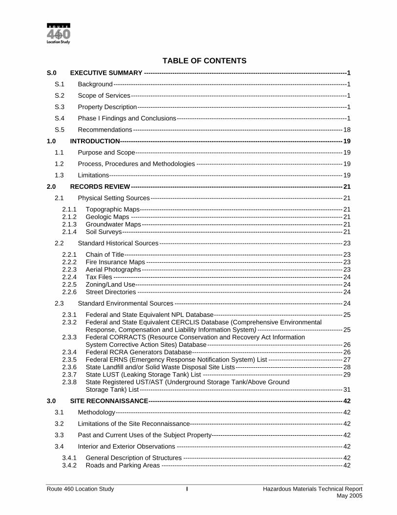
TABLE OF CONTENTS S.0 EXECUTIVE SUMMARY ---------------------------------------------------------------------------------------------1
S.1 Background -----------------------------------------------------------------------------------------------------------1 S.2 Scope of Services---------------------------------------------------------------------------------------------------1 S.3 Property Description------------------------------------------------------------------------------------------------1 S.4 Phase I Findings and Conclusions------------------------------------------------------------------------------1 S.5 Recommendations ------------------------------------------------------------------------------------------------ 18
1.0 INTRODUCTION------------------------------------------------------------------------------------------------------ 19 1.1 Purpose and Scope----------------------------------------------------------------------------------------------- 19 1.2 Process, Procedures and Methodologies ------------------------------------------------------------------- 19 1.3 Limitations----------------------------------------------------------------------------------------------------------- 19
2.0 RECORDS REVIEW ------------------------------------------------------------------------------------------------- 21 2.1 Physical Setting Sources---------------------------------------------------------------------------------------- 21
2.1.1 Topographic Maps--------------------------------------------------------------------------------------------- 21 2.1.2 Geologic Maps ------------------------------------------------------------------------------------------------- 21 2.1.3 Groundwater Maps-------------------------------------------------------------------------------------------- 21 2.1.4 Soil Surveys----------------------------------------------------------------------------------------------------- 21
2.2 Standard Historical Sources ------------------------------------------------------------------------------------ 23 2.2.1 Chain of Title---------------------------------------------------------------------------------------------------- 23 2.2.2 Fire Insurance Maps ------------------------------------------------------------------------------------------ 23 2.2.3 Aerial Photographs -------------------------------------------------------------------------------------------- 23 2.2.4 Tax Files --------------------------------------------------------------------------------------------------------- 24 2.2.5 Zoning/Land Use----------------------------------------------------------------------------------------------- 24 2.2.6 Street Directories ---------------------------------------------------------------------------------------------- 24
2.3 Standard Environmental Sources ----------------------------------------------------------------------------- 24 2.3.1 Federal and State Equivalent NPL Database----------------------------------------------------------- 25 2.3.2 Federal and State Equivalent CERCLIS Database (Comprehensive Environmental
Response, Compensation and Liability Information System) --------------------------------------- 25 2.3.3 Federal CORRACTS (Resource Conservation and Recovery Act Information
System Corrective Action Sites) Database-------------------------------------------------------------- 26 2.3.4 Federal RCRA Generators Database--------------------------------------------------------------------- 26 2.3.5 Federal ERNS (Emergency Response Notification System) List ---------------------------------- 27 2.3.6 State Landfill and/or Solid Waste Disposal Site Lists ------------------------------------------------- 28 2.3.7 State LUST (Leaking Storage Tank) List ---------------------------------------------------------------- 29 2.3.8 State Registered UST/AST (Underground Storage Tank/Above Ground
Storage Tank) List --------------------------------------------------------------------------------------------- 31 3.0 SITE RECONNAISSANCE----------------------------------------------------------------------------------------- 42
3.1 Methodology-------------------------------------------------------------------------------------------------------- 42 3.2 Limitations of the Site Reconnaissance---------------------------------------------------------------------- 42 3.3 Past and Current Uses of the Subject Property------------------------------------------------------------ 42 3.4 Interior and Exterior Observations ---------------------------------------------------------------------------- 42
3.4.1 General Description of Structures ------------------------------------------------------------------------- 42 3.4.2 Roads and Parking Areas ----------------------------------------------------------------------------------- 42

Route 460 Location Study II Hazardous Materials Technical Report May 2005
3.4.3 Hazardous Substances and Petroleum Products Containers -------------------------------------- 42 3.4.4 Underground Storage Tanks (USTs) and Aboveground Storage Tanks (ASTs)--------------- 43 3.4.5 Polychlorinated Biphenyls (PCBs)------------------------------------------------------------------------- 43 3.4.6 Solid Waste ----------------------------------------------------------------------------------------------------- 43 3.4.7 Pools of Liquid-------------------------------------------------------------------------------------------------- 43 3.4.8 Odors ------------------------------------------------------------------------------------------------------------- 43 3.4.9 Stained Soil or Pavement------------------------------------------------------------------------------------ 43 3.4.10 Stressed Vegetation --------------------------------------------------------------------------------------- 43 3.4.11 Stormwater and Wastewater----------------------------------------------------------------------------- 43 3.4.12 Pits, Ponds or Lagoons ----------------------------------------------------------------------------------- 44 3.4.13 Wells ----------------------------------------------------------------------------------------------------------- 44 3.4.14 Interior Utilities and Equipment-------------------------------------------------------------------------- 44
3.5 Current Land Uses of Adjoining Properties ----------------------------------------------------------------- 44 4.0 INTERVIEWS---------------------------------------------------------------------------------------------------------- 45 5.0 REFERENCES -------------------------------------------------------------------------------------------------------- 46
List of Tables TABLE 1 NUMBER OF HAZARDOUS MATERIALS OCCURRENCES IDENTIFIED BY CBA ----------2 TABLE 2. HAZARDOUS MATERIALS SITES IDENTIFIED FOR FURTHER EVALUATION -------------3 TABLE 3 RECOGNIZABLE ENVIRONMENTAL CONDITIONS (RECS) --------------------------------------4 TABLE 2.3-1 STANDARD ENVIRONMENTAL RECORD SOURCES -------------------------------------------- 25
List of Figures FIGURE 1 HAZARDOUS MATERIALS SITE SELECTION DATABASE ----------------------------------- 17

Route 460 Location Study 1 Hazardous Materials Technical Report May 2005
S.0 EXECUTIVE SUMMARY
S.1 BACKGROUND
Three Candidate Build Alternatives (CBAs) for the Route 460 Location Study are proposed. The study area extends from Petersburg to Suffolk (hereinafter referred to as “the subject property”). Figure 1 is a site map, which shows the subject property, adjoining property and Recognized Environmental Conditions (RECs).
The purpose of this Phase I ESA, is to address the "innocent landowner defense" provision of the Comprehensive Environmental Response, Compensation and Liability Act (CERCLA) of 1980 and "all appropriate inquiry" into the ownership and uses of the property in preparation of due diligence investigations under the Superfund Amendments and Reauthorization Act (SARA) of 1986.
S.2 SCOPE OF SERVICES
This Phase I ESA is in general accordance with ASTM Standard E 1527-00.
S.3 PROPERTY DESCRIPTION
The subject property consists of the area just east of Petersburg and extends to Suffolk, including the following localities: Disputanta, Waverly, Wakefield, Dendron, Ivor, Zuni and Windsor, a small northern portion of Suffolk, the majority of Isle of Wight, and western portions of Surry, Rushmere and Smithfield. The study area currently consists of primarily agricultural and residential tracts with some industrial and commercial property. Based on the aerial photography, it appears that 5%-10% of the study area is industrial and commercial. The densest development and the majority of commercial and industrial properties are located proximal to each of the localities. Several secondary roadways and waterways and one railway lie within the study area, as does U.S. 460. Three known airfields exist within the study area, including: Garner Airport landing strip (between Suffolk and Windsor), the Wakefield Municipal Airport and a landing strip between Waverly and Disputanta (just east of U.S. 460), and vacant land. Table 3 includes information and more detailed property descriptions for parcels potentially exhibiting hazardous or petroleum product use. A site map showing the subject property and adjacent property is included as Figure 1.
The subject property is bound by the City of Petersburg to the west, the City of Suffolk to the east, and the Counties of Prince George, Surry, Sussex, Surry, Southampton and Isle of Wight to the north, and the Counties of Prince George, Surry, Sussex, Southampton and Isle of Wight to the south.
S.4 PHASE I FINDINGS AND CONCLUSIONS
Hazardous Materials Sites Identified
The database occurrences identify sites that could potentially affect the three CBA corridors. If a known or potential hazardous waste site affects an alternative, information about the site, the potential involvement, impacts, public health concerns and proposed mitigation measures are addressed.
Table 1 lists the number of mapped occurrences identified for each CBA considered. A total of 192 sites are located within the corridor. There are 131 mapped sites and 61 unmapped sites. The unmapped sites were not located. There is a potential that the unmapped sites are no longer in existence. Additionally, it is possible that the unmapped sites are the same as some of the mapped sites, with only a change of name. Only five of these unmapped sites are LUSTs. Of the total number of sites identified within the corridor, 26 are LUSTs. Some of the LUSTs may affect more than one alternative. In addition to the LUSTs identified in the database search, there are a number of former and potential former gasoline stations, some with
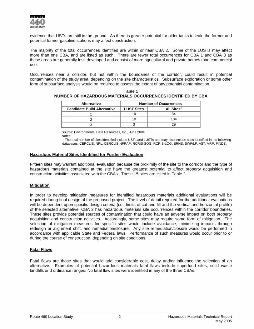
Route 460 Location Study 2 Hazardous Materials Technical Report May 2005
evidence that USTs are still in the ground. As there is greater potential for older tanks to leak, the former and potential former gasoline stations may affect construction.
The majority of the total occurrences identified are within or near CBA 2. Some of the LUSTs may affect more than one CBA, and are listed as such. There are fewer total occurrences for CBA 1 and CBA 3 as these areas are generally less developed and consist of more agricultural and private homes than commercial use.
Occurrences near a corridor, but not within the boundaries of the corridor, could result in potential contamination of the study area, depending on the site characteristics. Subsurface exploration or some other form of subsurface analysis would be required to assess the extent of any potential contamination.
Table 1 NUMBER OF HAZARDOUS MATERIALS OCCURRENCES IDENTIFIED BY CBA
Alternative Number of Occurrences Candidate Build Alternative LUST Sites All Sites1
1 10 34 2 10 104 3 3 29
Source: Environmental Data Resources, Inc., June 2004. Notes: 1. The total number of sites identified include USTs and LUSTs and may also include sites identified in the following databases: CERCLIS, NPL, CERCLIS-NFRAP, RCRIS-SQG, RCRIS-LQG, ERNS, SWF/LF, AST, VRP, FINDS.
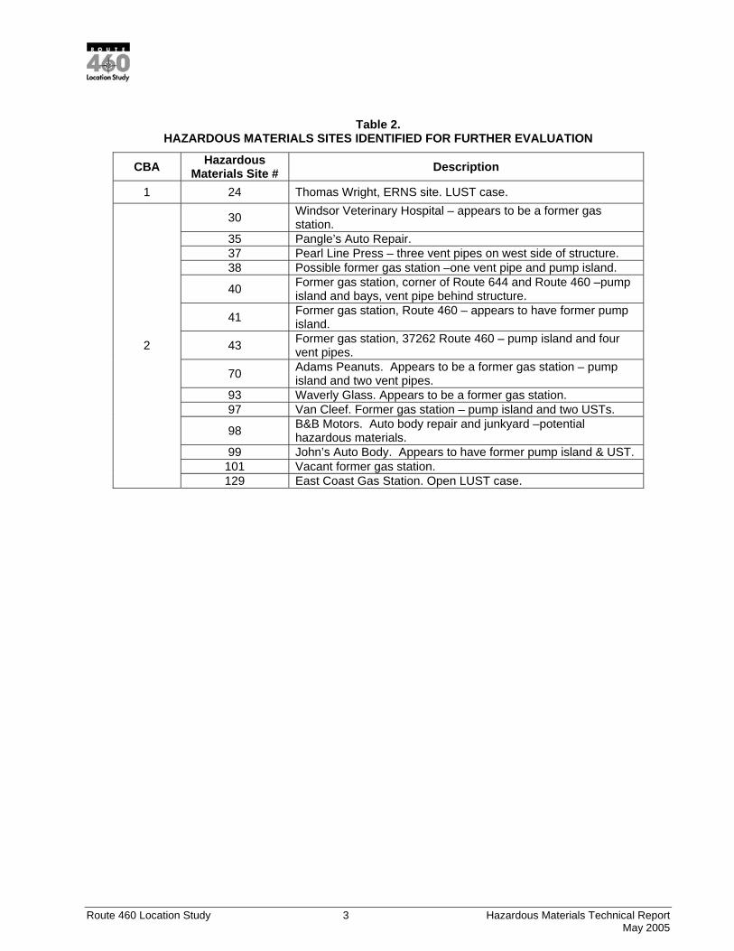
Hazardous Material Sites Identified for Further Evaluation
Fifteen sites may warrant additional evaluation because the proximity of the site to the corridor and the type of hazardous materials contained at the site have the greatest potential to affect property acquisition and construction activities associated with the CBAs. These 15 sites are listed in Table 2.
Mitigation
In order to develop mitigation measures for identified hazardous materials additional evaluations will be required during final design of the proposed project. The level of detail required for the additional evaluations will be dependent upon specific design criteria (i.e., limits of cut and fill and the vertical and horizontal profile) of the selected alternative. CBA 2 has hazardous materials site occurrences within the corridor boundaries. These sites provide potential sources of contamination that could have an adverse impact on both property acquisition and construction activities. Accordingly, some sites may require some form of mitigation. The selection of mitigation measures for specific sites would include avoidance, minimizing impacts through redesign or alignment shift, and remediation/closure. Any site remediation/closure would be performed in accordance with applicable State and Federal laws. Performance of such measures would occur prior to or during the course of construction, depending on site conditions.
Fatal Flaws
Fatal flaws are those sites that would add considerable cost, delay and/or influence the selection of an alternative. Examples of potential hazardous materials fatal flaws include superfund sites, solid waste landfills and ordinance ranges. No fatal flaw sites were identified in any of the three CBAs.
Route 460 Location Study 3 Hazardous Materials Technical Report May 2005
Table 2. HAZARDOUS MATERIALS SITES IDENTIFIED FOR FURTHER EVALUATION
CBA Hazardous Materials Site # Description
1 24 Thomas Wright, ERNS site. LUST case.
30 Windsor Veterinary Hospital – appears to be a former gas station.
35 Pangle’s Auto Repair. 37 Pearl Line Press – three vent pipes on west side of structure. 38 Possible former gas station –one vent pipe and pump island.
40 Former gas station, corner of Route 644 and Route 460 –pump island and bays, vent pipe behind structure.
41 Former gas station, Route 460 – appears to have former pump island.
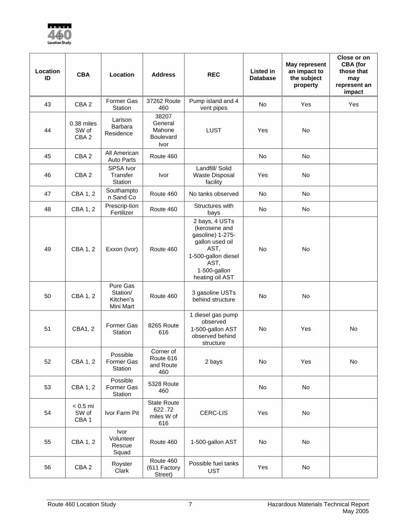
43 Former gas station, 37262 Route 460 – pump island and four vent pipes.
70 Adams Peanuts. Appears to be a former gas station – pump island and two vent pipes.
93 Waverly Glass. Appears to be a former gas station. 97 Van Cleef. Former gas station – pump island and two USTs.
98 B&B Motors. Auto body repair and junkyard –potential hazardous materials.
99 John’s Auto Body. Appears to have former pump island & UST. 101 Vacant former gas station.
2
129 East Coast Gas Station. Open LUST case.
Route 460 Location Study 4 Hazardous Materials Technical Report May 2005
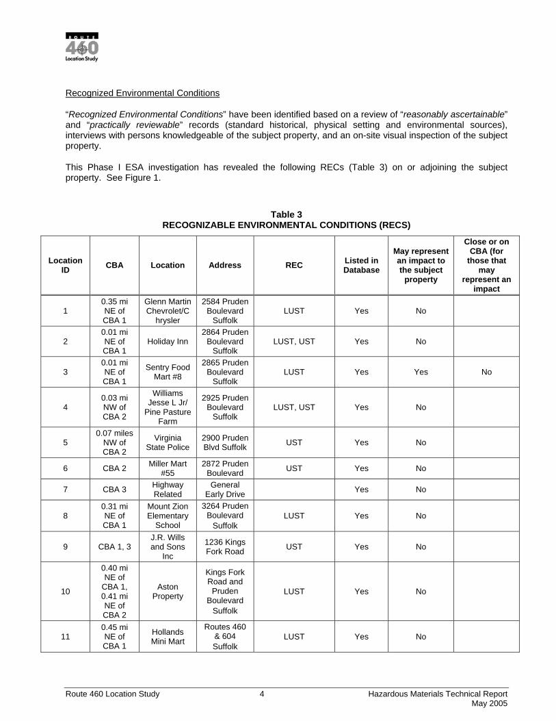
Recognized Environmental Conditions
“Recognized Environmental Conditions” have been identified based on a review of “reasonably ascertainable” and “practically reviewable” records (standard historical, physical setting and environmental sources), interviews with persons knowledgeable of the subject property, and an on-site visual inspection of the subject property.
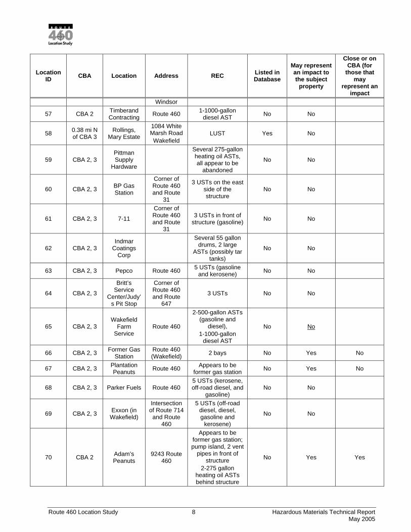
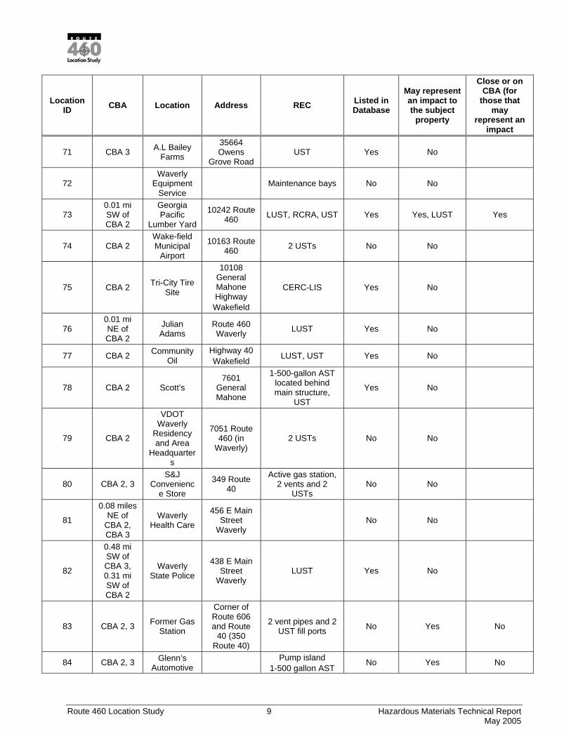
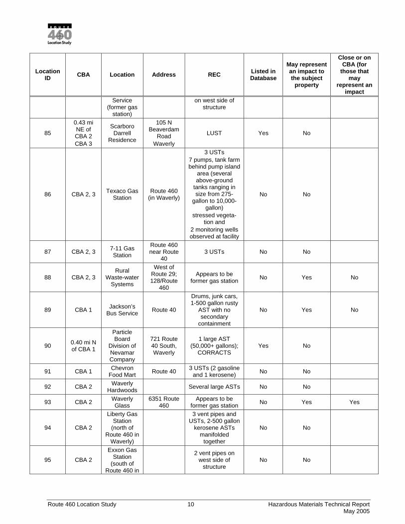
This Phase I ESA investigation has revealed the following RECs (Table 3) on or adjoining the subject property. See Figure 1.
Table 3 RECOGNIZABLE ENVIRONMENTAL CONDITIONS (RECS)
Location ID CBA Location Address REC Listed in
Database
May represent an impact to the subject
property
Close or on CBA (for
those that may
represent an impact
1 0.35 mi NE of CBA 1
Glenn Martin Chevrolet/C
hrysler
2584 Pruden Boulevard
Suffolk LUST Yes No
2 0.01 mi NE of CBA 1
Holiday Inn 2864 Pruden
Boulevard Suffolk
LUST, UST Yes No
3 0.01 mi NE of CBA 1
Sentry Food Mart #8
2865 Pruden Boulevard
Suffolk LUST Yes Yes No
4 0.03 mi NW of CBA 2
Williams Jesse L Jr/
Pine Pasture Farm
2925 Pruden Boulevard
Suffolk LUST, UST Yes No
5 0.07 miles
NW of CBA 2
Virginia State Police
2900 Pruden Blvd Suffolk UST Yes No
6 CBA 2 Miller Mart #55
2872 Pruden Boulevard UST Yes No
7 CBA 3 Highway Related
General Early Drive Yes No
8 0.31 mi NE of CBA 1
Mount Zion Elementary
School
3264 Pruden Boulevard
Suffolk LUST Yes No
9 CBA 1, 3 J.R. Wills and Sons
Inc
1236 Kings Fork Road UST Yes No
10
0.40 mi NE of
CBA 1, 0.41 mi NE of CBA 2
Aston Property
Kings Fork Road and Pruden
Boulevard Suffolk
LUST Yes No
11 0.45 mi NE of CBA 1
Hollands Mini Mart
Routes 460 & 604 Suffolk
LUST Yes No
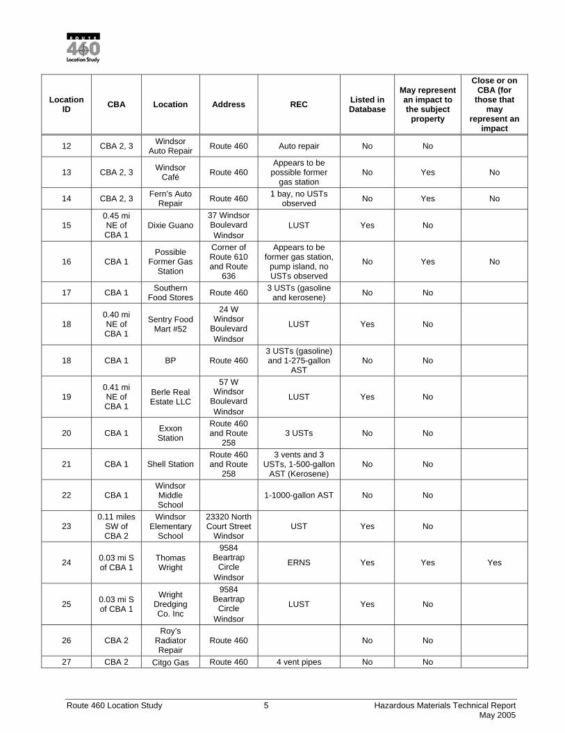
Route 460 Location Study 5 Hazardous Materials Technical Report May 2005
Location ID CBA Location Address REC Listed in
Database
May represent an impact to the subject
property
Close or on CBA (for
those that may
represent an impact
12 CBA 2, 3 Windsor Auto Repair Route 460 Auto repair No No
13 CBA 2, 3 Windsor Café Route 460
Appears to be possible former
gas station No Yes No
14 CBA 2, 3 Fern’s Auto Repair Route 460 1 bay, no USTs
observed No Yes No
15 0.45 mi NE of CBA 1
Dixie Guano 37 Windsor Boulevard Windsor
LUST Yes No
16 CBA 1 Possible
Former Gas Station
Corner of Route 610 and Route
636
Appears to be former gas station,
pump island, no USTs observed
No Yes No
17 CBA 1 Southern Food Stores Route 460 3 USTs (gasoline
and kerosene) No No
18 0.40 mi NE of CBA 1
Sentry Food Mart #52
24 W Windsor
Boulevard Windsor
LUST Yes No
18 CBA 1 BP Route 460 3 USTs (gasoline) and 1-275-gallon
AST No No
19 0.41 mi NE of CBA 1
Berle Real Estate LLC
57 W Windsor
Boulevard Windsor
LUST Yes No
20 CBA 1 Exxon Station
Route 460 and Route
258 3 USTs No No
21 CBA 1 Shell Station Route 460 and Route
258
3 vents and 3 USTs, 1-500-gallon
AST (Kerosene) No No
22 CBA 1 Windsor Middle School
1-1000-gallon AST No No
23 0.11 miles
SW of CBA 2
Windsor Elementary
School
23320 North Court Street
Windsor UST Yes No
24 0.03 mi S of CBA 1
Thomas Wright
9584 Beartrap
Circle Windsor
ERNS Yes Yes Yes
25 0.03 mi S of CBA 1
Wright Dredging Co. Inc
9584 Beartrap
Circle Windsor
LUST Yes No
26 CBA 2 Roy’s
Radiator Repair
Route 460 No No
27 CBA 2 Citgo Gas Route 460 4 vent pipes No No
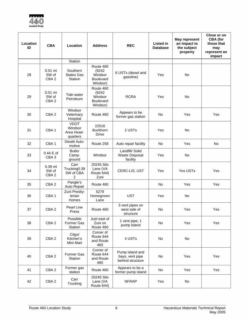
Route 460 Location Study 6 Hazardous Materials Technical Report May 2005
Location ID CBA Location Address REC Listed in
Database
May represent an impact to the subject
property
Close or on CBA (for
those that may
represent an impact
Station
28 0.01 mi SW of CBA 2
Southern States Gas
Station
Route 460 (9242
Windsor Boulevard Windsor)
6 USTs (diesel and gasoline) Yes No
29 0.01 mi SW of CBA 2
Tide-water Petroleum
Route 460 (9242
Windsor Boulevard Windsor)
RCRA Yes No
30 CBA 2 Windsor
Veterinary Hospital
Route 460 Appears to be former gas station No Yes Yes
31 CBA 1
VDOT Windsor
Area Head-quarters
22516 Buckhorn
Drive 2 USTs Yes No
32 CBA 1 Dewitt Auto-motive Route 258 Auto repair facility No Yes No
33 0.44 E of CBA 3
Butler Camp-ground
Windsor Landfill/ Solid
Waste Disposal facility
Yes No
34 0.39 mi SW of CBA 2
Carr Trucking0.39 SW of CBA
2
20245 Silo Lane (VA
Route 644) Zuni
CERC-LIS, UST Yes Yes USTs Yes
35 CBA 2 Pangle’s Auto Repair Route 460 No Yes Yes
36 CBA 1 Zuni Presby-
terian Homes
5279 Homegrown
Lane UST Yes No
37 CBA 2 Pearl Line Press Route 460
3 vent pipes on west side of
structure No Yes Yes
38 CBA 2 Possible
Former Gas Station
Just east of Zuni on
Route 460
1 vent pipe, 1 pump island No Yes Yes
39 CBA 2 Citgo/
Kitchen’s Mini Mart
Corner of Route 644 and Route
460
4 USTs No No
40 CBA 2 Former Gas Station
Corner of Route 644 and Route
460
Pump island and bays, vent pipe behind structure
No Yes Yes
41 CBA 2 Former gas station Route 460 Appears to be a
former pump island No Yes Yes
42 CBA 2 Carr Trucking
20245 Silo Lane (VA
Route 644) NFRAP Yes No
Route 460 Location Study 7 Hazardous Materials Technical Report May 2005
Location ID CBA Location Address REC Listed in
Database
May represent an impact to the subject
property
Close or on CBA (for
those that may
represent an impact
43 CBA 2 Former Gas Station
37262 Route 460
Pump island and 4 vent pipes No Yes Yes
44 0.38 miles
SW of CBA 2
Larison Barbara
Residence
38207 General Mahone
Boulevard Ivor
LUST Yes No
45 CBA 2 All American Auto Parts Route 460 No No
46 CBA 2 SPSA Ivor Transfer Station
Ivor Landfill/ Solid
Waste Disposal facility
Yes No
47 CBA 1, 2 Southampton Sand Co Route 460 No tanks observed No No
48 CBA 1, 2 Prescrip-tion Fertilizer Route 460 Structures with
bays No No
49 CBA 1, 2 Exxon (Ivor) Route 460
2 bays, 4 USTs (kerosene and
gasoline) 1-275-gallon used oil
AST, 1-500-gallon diesel
AST, 1-500-gallon
heating oil AST
No No
50 CBA 1, 2
Pure Gas Station/
Kitchen’s Mini Mart
Route 460 3 gasoline USTs behind structure No No
51 CBA1, 2 Former Gas Station
8265 Route 616
1 diesel gas pump observed
1-500-gallon AST observed behind
structure
No Yes No
52 CBA 1, 2 Possible
Former Gas Station
Corner of Route 616 and Route
460
2 bays No Yes No
53 CBA 1, 2 Possible
Former Gas Station
5328 Route 460 No No
54 < 0.5 mi SW of CBA 1
Ivor Farm Pit
State Route 622 .72
miles W of 616
CERC-LIS Yes No
55 CBA 1, 2
Ivor Volunteer Rescue Squad
Route 460 1-500-gallon AST No No
56 CBA 2 Royster Clark
Route 460 (611 Factory
Street)
Possible fuel tanks UST Yes No
Route 460 Location Study 8 Hazardous Materials Technical Report May 2005
Location ID CBA Location Address REC Listed in
Database
May represent an impact to the subject
property
Close or on CBA (for
those that may
represent an impact
Windsor
57 CBA 2 Timberand Contracting Route 460 1-1000-gallon
diesel AST No No
58 0.38 mi N of CBA 3
Rollings, Mary Estate
1084 White Marsh Road Wakefield
LUST Yes No
59 CBA 2, 3 Pittman Supply
Hardware
Several 275-gallon heating oil ASTs, all appear to be
abandoned
No No
60 CBA 2, 3 BP Gas Station
Corner of Route 460 and Route
31
3 USTs on the east side of the structure
No No
61 CBA 2, 3 7-11
Corner of Route 460 and Route
31
3 USTs in front of structure (gasoline) No No
62 CBA 2, 3 Indmar
Coatings Corp
Several 55 gallon drums, 2 large
ASTs (possibly tar tanks)
No No
63 CBA 2, 3 Pepco Route 460 5 USTs (gasoline and kerosene) No No
64 CBA 2, 3
Britt’s Service
Center/Judy’s Pit Stop
Corner of Route 460 and Route
647
3 USTs No No
65 CBA 2, 3 Wakefield
Farm Service
Route 460
2-500-gallon ASTs (gasoline and
diesel), 1-1000-gallon
diesel AST
No No
66 CBA 2, 3 Former Gas Station
Route 460 (Wakefield) 2 bays No Yes No
67 CBA 2, 3 Plantation Peanuts Route 460 Appears to be
former gas station No Yes No
68 CBA 2, 3 Parker Fuels Route 460 5 USTs (kerosene, off-road diesel, and
gasoline) No No
69 CBA 2, 3 Exxon (in Wakefield)
Intersection of Route 714 and Route
460
5 USTs (off-road diesel, diesel, gasoline and
kerosene)
No No
70 CBA 2 Adam’s Peanuts
9243 Route 460
Appears to be former gas station; pump island, 2 vent
pipes in front of structure
2-275 gallon heating oil ASTs behind structure
No Yes Yes
Route 460 Location Study 9 Hazardous Materials Technical Report May 2005
Location ID CBA Location Address REC Listed in
Database
May represent an impact to the subject
property
Close or on CBA (for
those that may
represent an impact
71 CBA 3 A.L Bailey Farms
35664 Owens
Grove Road UST Yes No
72 Waverly
Equipment Service
Maintenance bays No No
73 0.01 mi SW of CBA 2
Georgia Pacific
Lumber Yard
10242 Route 460 LUST, RCRA, UST Yes Yes, LUST Yes
74 CBA 2 Wake-field Municipal
Airport
10163 Route 460 2 USTs No No
75 CBA 2 Tri-City Tire Site
10108 General Mahone Highway
Wakefield
CERC-LIS Yes No
76 0.01 mi NE of CBA 2
Julian Adams
Route 460 Waverly LUST Yes No
77 CBA 2 Community Oil
Highway 40 Wakefield LUST, UST Yes No
78 CBA 2 Scott’s 7601
General Mahone
1-500-gallon AST located behind main structure,
UST
Yes No
79 CBA 2
VDOT Waverly
Residency and Area
Headquarters
7051 Route 460 (in
Waverly) 2 USTs No No
80 CBA 2, 3 S&J
Convenience Store
349 Route 40
Active gas station, 2 vents and 2
USTs No No
81
0.08 miles NE of
CBA 2, CBA 3
Waverly Health Care
456 E Main Street
Waverly No No
82
0.48 mi SW of CBA 3, 0.31 mi SW of CBA 2
Waverly State Police
438 E Main Street
Waverly LUST Yes No
83 CBA 2, 3 Former Gas Station
Corner of Route 606 and Route
40 (350 Route 40)
2 vent pipes and 2 UST fill ports No Yes No
84 CBA 2, 3 Glenn’s Automotive Pump island
1-500 gallon AST No Yes No
Route 460 Location Study 10 Hazardous Materials Technical Report May 2005
Location ID CBA Location Address REC Listed in
Database
May represent an impact to the subject
property
Close or on CBA (for
those that may
represent an impact
Service (former gas
station)
on west side of structure
85
0.43 mi NE of CBA 2 CBA 3
Scarboro Darrell
Residence
105 N Beaverdam
Road Waverly
LUST Yes No
86 CBA 2, 3 Texaco Gas Station
Route 460 (in Waverly)
3 USTs 7 pumps, tank farm behind pump island
area (several above-ground
tanks ranging in size from 275-
gallon to 10,000-gallon)
stressed vegeta-tion and
2 monitoring wells observed at facility
No No
87 CBA 2, 3 7-11 Gas Station
Route 460 near Route
40 3 USTs No No
88 CBA 2, 3 Rural
Waste-water Systems
West of Route 29; 128/Route
460
Appears to be former gas station No Yes No
89 CBA 1 Jackson’s Bus Service Route 40
Drums, junk cars, 1-500 gallon rusty
AST with no secondary
containment
No Yes No
90 0.40 mi N of CBA 1
Particle Board
Division of Nevamar Company
721 Route 40 South, Waverly
1 large AST (50,000+ gallons);
CORRACTS Yes No
91 CBA 1 Chevron Food Mart Route 40 3 USTs (2 gasoline
and 1 kerosene) No No
92 CBA 2 Waverly Hardwoods Several large ASTs No No
93 CBA 2 Waverly Glass
6351 Route 460
Appears to be former gas station No Yes Yes
94 CBA 2
Liberty Gas Station
(north of Route 460 in
Waverly)
3 vent pipes and USTs, 2-500 gallon
kerosene ASTs manifolded
together
No No
95 CBA 2 Exxon Gas
Station (south of
Route 460 in
2 vent pipes on
west side of structure
No No
Route 460 Location Study 11 Hazardous Materials Technical Report May 2005
Location ID CBA Location Address REC Listed in
Database
May represent an impact to the subject
property
Close or on CBA (for
those that may
represent an impact
Waverly)
96 CBA 2 NAPA Store 1-500 gallon gasoline AST No No
97 0.02 mi SW of CBA 2
Van Cleef (former gas
station), adjacent
NAPA Store
5556, 5578, 5584 4Route
460
Inactive pump island
2 USTs, 1 pump labeled diesel
1-500 gallon AST (un-known), UST
Yes Yes Yes
98 CBA 2 B&B Motors 4362 Route 460
Auto body repair and junkyard No Yes Yes
99 0.02 mi SW of CBA 2
John’s Auto Body
Route 460 (4216
General Mahone Waverly)
Appears to have former pump island, UST
Yes Yes Yes
100 0.01 mi SW of CBA 2
Spurlock Adhesives
Inc.
5090 General Mahone
Hwy
UST Yes No
100 0.01 mi SW of CBA 2
Spurloch
5090 General Mahone
Hwy
UST Yes No
100 CBA 2 Borden Chem Inc
5090 General Mahone
Hwy, Waverly
RCRA Yes No
101 CBA 2 Vacant
Former Gas Station
Route 460 No visual evidence of tanks No Yes Yes
102 CBA 2
Sussex Service
Authority (Pump Station)
Route 460 1-500 gallon diesel AST Yes No
103 0.01 mi SW of CBA 2
Carrolls Foods of
Virginia Inc.
HWY 460 West,
Waverly RCRA Yes No
103 CBA 2 Carrolls
Food Feed Mill
27404 Gen Mahone
Hwy UST Yes No
104 CBA 2
Cavalier Quick Stop (former gas
station)
Route 460
2 vent pipes on west side of
structure, stressed vegetation,
petroleum odors, UST
Yes No
105 CBA 2 PG/Sussex
Communication Tower
Route 460 UST Yes No
Route 460 Location Study 12 Hazardous Materials Technical Report May 2005
Location ID CBA Location Address REC Listed in
Database
May represent an impact to the subject
property
Close or on CBA (for
those that may
represent an impact
106 CBA 2 Former Gas Station Route 460 No Yes No
107 CBA 2
Brian’s Automotive (appears to be a former gas station)
Northeast corner of
625 and 460 (10054 County Drive)
Possible former pump island, no
visible evidence of tanks
No Yes No
108 CBA 2
Disputanta Volunteer
Fire Department
1000 County Drive
1-550 gallon diesel AST No No
109 CBA 2 Russell Padgett
13103 Hines Rd UST Yes No
110 0.07 miles SE of CBA
2
Harrison Elementary
School
2900 E Quaker Rd
Prince George
UST Yes No
111 CBA 2
Walden’s Barber Shop and Beauty
Salon
9718 County Drive
Old pump island, 1 vent pipe west side
of building No Yes
112 CBA 2 Former
Texaco Gas Station
Intersection of 618S and
460
4 USTs (3 larger and 1 smaller) No Yes No
113 CBA 2 Kitchen’s Stop and
Shop
9901 County Road UST Yes No
114 0.11 miles
SW of CBA 2
Prince George Golf
8401 Golf Course
Drive Prince George
UST Yes No
115 CBA 2 Shell Gas Station
SE Corner Routes 460
and 156
7 vent pipes and 7 USTs No No
116 CBA 2 Seiberts 460
Texaco Truck Stop
7201 County Drive,
Disputanta RCRA, UST Yes No
117 CBA 2
Standard Motor
Products, Inc.
2 large ASTs, RCRA Yes No
118 0.06 mi SW of CBA 2
JEJ Moore Middle School
No tanks observed, UST Yes No
119 CBA 2 Food Lion
Distribution Center
Between Routes 460
and 630
1-50,00+ gallon AST; LUST; ERNS,
UST Yes No –closed
LUST case
120 CBA 2 Prince George
Emergency Crew
10800 Route 156
1-500 gallon AST (½ diesel, ½
gasoline); 2nd vent pipe at building
No No
Route 460 Location Study 13 Hazardous Materials Technical Report May 2005
Location ID CBA Location Address REC Listed in
Database
May represent an impact to the subject
property
Close or on CBA (for
those that may
represent an impact
Rescue Squad
between bays
121 CBA 2 Spencer Propane Company
PO Box 1538 1500-gallon AST No No
122 0.06 miles
NE of CBA 2
Petersburg Jail Farm
6104 County Drive
Disputanta UST No No
123 0.12 mi SW of CBA 2
Country Classics
6103 Country
Drive Disputanta
LUST; 275-gallon AST east of
building, UST Yes No
124 CBA 2 Truck
Service of Virginia
1-500 gallon AST behind building, 1-
used oil AST behind shed
No No
125 CBA 2 Agri-nutrients
5114 Route 460 Large AST No No
126 CBA 2 B and D Collision Center
5112 Route 460,
Disputanta
Appears to be former gas station, no tanks observed
RCRA
Yes No
127 0.03 mi NE of CBA 2
Southside Ford Tractor
Highway 460 E
Petersburg UST Yes No
128 0.03 mi NE of CBA 2
McLean Tom’s Petersburg UST Yes No
129 CBA 2 East Coast Gas Station Disputanta UST, LUST Yes Yes from
LUST Yes
130 0.07 mi NE of CBA 1
Triangle Market Former
4605 County Drive
Disputanta LUST Yes No
131 0.99 SW of CBA 3
Boehringer Ingleheim Chemicals
Inc.
Petersburg CORRACTS Yes No
Unmapped
CBA 1 Swift Agri Chem Corp. Suffolk CERCLIS Yes No
<1 mi CBA 1
MR Industries Will Roy
Industries PK Site 63
Suffolk COR-RACTS Yes No
CBA 2 State Route 460 East Wakefield ERNS Yes Yes
CBA 2 Plant Food Products
3460 General Mahone
Blvd, Ivor
ERNS Yes No

Route 460 Location Study 14 Hazardous Materials Technical Report May 2005
Location ID CBA Location Address REC Listed in
Database
May represent an impact to the subject
property
Close or on CBA (for
those that may
represent an impact
Unmapped Gray
Lumber Company
Main Street Waverly
Landfill/Solid Waste Disposal,
LUST, UST Yes No
Unmapped Nottoway County Landfill
Waverly Landfill/Solid Waste Disposal Yes No
Unmapped
Southampton County Landfill – Ivor #2
Ivor Landfill/Solid Waste Disposal Yes No
Unmapped Suffolk City Landfill
Hozier Road Suffolk
Landfill/Solid Waste Disposal Yes No
Unmapped GTE Facility High St Wakefield LUST, UST Yes No
Unmapped Seberas Country Store
Route 106 Prince George
LUST, UST Yes No
Unmapped Sussex Bulk Oil Facility
Route 460 & 714
Wakefield LUST Yes Yes
Unmapped West Main
Street Pump Station
West Main Street
Waverly LUST Yes No
CBA 2 Zuni Amoco Route 460 UST Yes No
CBA 2 Zuni Peanut Co Route 460 UST Yes No
Unmapped Bank of Isle of Wight
Route 460 Wakefield
UST Yes No
Unmapped Beale Boys Route 40 Waverly UST Yes No
Unmapped Brandon Plantation
23105 Brandon
Road Spring Grove
UST Yes No
Unmapped Chips Market
Route 460 Waverly UST Yes No
Unmapped Clantons Electric
Main Street Waverly UST Yes No
Unmapped Cobbs Automotive
Route 760 Wakefield UST Yes No
Unmapped DL Magee Waverly UST Yes No
Unmapped East End Service
W Main Street
Waverly UST Yes No
Unmapped Express Mart #4
Route 40 W Waverly UST Yes No
Unmapped Former Harrups Super-
Ivor Road Ivor UST Yes No

Route 460 Location Study 15 Hazardous Materials Technical Report May 2005
Location ID CBA Location Address REC Listed in
Database
May represent an impact to the subject
property
Close or on CBA (for
those that may
represent an impact
market
Unmapped Gladys Walker
Country Drive
Disputanta UST Yes No
Unmapped Good-man and Holland
Route 610 Windsor UST Yes No
Unmapped HW Wade Highway 616 Ivor UST Yes No
Unmapped Hilltop Truck Stop
Route 460 Ivor UST Yes No
Unmapped JE Nash and Son
Route 460 Ivor UST Yes No
Unmapped JR Andrews Farm
Highway 617 Wakefield UST Yes No
Unmapped James T Jones
Route 2 Box 50 Windsor UST Yes No
Unmapped John D Nurney
Route 3 Box 106 Windsor UST Yes No
Unmapped John D Crocker
Route 2 Box 163 Ivor UST Yes No
Unmapped LA Brantly Farm
Highway 616 Ivor UST Yes No
Unmapped L Frank Byrum Jr
Route 2 Box 2663
Windsor UST Yes No
Unmapped Lanier Felix B
Main Street Wakefield UST Yes No
Unmapped Larry Lee Neave Farm
Route 1 Box 86 Ivor UST Yes No
Unmapped Leonards Route 460 Ivor UST Yes No
Unmapped Midway Chevron
Route 460 Wakefield UST Yes No
Unmapped Mike Spain; Nottoway
Farms
Jerusalem Plank Road
Waverly UST Yes No
Unmapped Oberry Farm Supply
Route 3 Box 100 Windsor UST Yes No
Unmapped Padgett Brothers Waverly UST Yes No
Unmapped
Prince George
Emergency Crew
Building
Prince George Dr
Prince George
UST Yes No
Unmapped Rolley
Firewood Sales
Country Drive W
Disputanta UST Yes No
Unmapped SS Kea and Son
Route 460 Ivor UST Yes No
Route 460 Location Study 16 Hazardous Materials Technical Report May 2005
Location ID CBA Location Address REC Listed in
Database
May represent an impact to the subject
property
Close or on CBA (for
those that may
represent an impact
Unmapped SP Roeder Highway 460 W Waverly UST Yes No
Unmapped Scott Truck Lot
Route 258 S Windsor UST Yes No
Unmapped Stanley Turner
Route 3 Box 62 Windsor UST Yes No
Unmapped Stephenson Farms
Highway 628 Wakefield UST Yes No
Unmapped Sussex Farm
Equipment
Highway 460 E Waverly UST Yes No
Unmapped
Tidewater Farm and Garden Supply
PO Box 147 Windsor UST Yes No
Unmapped Wagon Wheel
Highway 460 Ivor UST Yes No
Unmapped Wakefield Chevron
555 County Drive
Wakefield
Unmapped Wakefield Texaco
Highway 460 Wakefield
Unmapped Windsor Truck-stop
Route 460 Windsor
Unmapped Woodys Chevron
Route 460 Wakefield
Unmapped Ye Old
Tobacco Shop
Route 460 Windsor
Unmapped Ivor
Furniture Company
Route 460 Ivor
Unmapped Windsor Shell
Windsor Blvd
Windsor
Unmapped Windsor Peanut
Company
Route 460 Windsor
Unmapped Windsor Inn Route 460 Windsor
*If not located at that CBA, the REC is closest to CBA(s) noted.
Unmapped sites could not be geolocated either because the sites are no longer there or have since changed names and potentially affect all alignments.

James RiverBurwell Bay
Cobham Bay
Pagan River
Western Branch Reservoir
Lake Prince
Lake Burnt Mills
Lake Cohoon
Lake Meade
Lake Kilby
Averys Pond
Airfield Pond
Lees Mill Pond
Sunken Meadow Pond
Honey Pond
Lake Tormentor
Johnsons Mill Pond
Nebletts Mill Pond
Isaac Walton Pond
Brittle Millpond
Spring Hill Pond
Whitefields Mill Pond
Lake Binford
Bryant Pond
Jenkins Swamp
Sadler Pond
Crumps Mill Pond
Hanzliks Pond
Freemans Millpond
Woodys Pond
Jenkins Pond
Scruggs Pond
Thackers Pond
Scotts Factory Pond
Slade Pond
Drum Wright Pond
Couches Pond
Cat Ponds
Murphy Pond
Courthouse Millpond
Lake Pitchkettle
Antioch Swamp
Seacock Swamp
Notto
way River
Mill
Sw
amp
Joseph Swamp
Cypress Swam p
Blackwater Ri ver
Blackwate
r River
2nd Swamp
Blackwater Swamp
Blackwater Swamp
Blackw ater Ri v e r
Warwick Swamp
Joseph SwampJoseph Swamp
Coppahaunk Swam p
Seacock S wamp
Seaco ck Swamp
Light w ood S w amp
Rattl
esna
ke Sw
am
p
Pouche s Swamp
Blackwater Rive rM
ill Swamp
Mill Swamp
Mill
Sw
amp
Passe
nger
Swam
p
Upper
Chi
ppok
es C
reek
Low
er
Chippokes Cree
k
Law
nes C
reek
Pagan River
Cypress Creek
Ja
nes
Cre
ek
Chuck
atuck
Cre
ek
Carbell Swam
p
Assamoosick S
Assam
oosick Swam
p
Nottow
ay River
Nottoway River
Jones Hole Swamp
wanty Creek
Warwi ck Swamp
Warw
ick Swamp
Sprin
g Bran
ch
Blackwater River
Coppahaunk Swam
p
Black Swamp
Chuckatuck Creek
El ey S wamp
Bla ckw
ater
Riv
erBl
ackw
ater
Rive
r
2nd Swamp
Mussel Creek
Seacock Swam
p
Pow
ell Creek
College Run
Stallin
gs C
reek
Green Sw
amp
Passenger Swam
p
ny Creek
Terrapin SwampW
ards
Cre
ek
G rays Creek
Round Hill Swamp
Seac
orrie
Sw
amp
Swamp
Austin Branch
Moores Swamp
Crou
ch C
re
ek
Pope Swamp
Pigeon Swamp
Hunting Quarter Creek
Blac
k Cr
eek
Ande rson Branch
Cabin Point Swamp
Great Swamp
Champion Sw amp
P ooles Creek
Lees Bra nch
Spring R un
Burnt Mill Swamp
German Swamp
Rowan ty Creek
Johnchecohunk Swamp
Corrowaugh Swamp
Dark Swamp
Pa
rkers
Branch
Rattlesnake Swamp
Villine s Swamp
Ivy Branch
Ot terdam Swamp
Brantley Swamp
Elwood Swamp
Isla
nd Sw
amp
Catt ail Swamp
Nuby Run
Indian Branch
Jones Hole Swamp
Assamoosick S wamp
Neb lett M
ill Run
Little S
Pig Swamp
Dicks S wamp
Warwick Swa mp
Thweatt Branch
Blac
k Bran
ch Swamp
Ducks Swamp
Hicka neck Swamp
Coh oon Creek
Spring Grove Swamp
Bailey
s Cree
k
B lackwater River
Lightwood Swamp
Comet Swamp
Gal ley Swamp
Baile
y Cr
eek
M
orris
Cree
k
N For k Blackwater Swamp
pomattox Rive
Mill F
arm R
un
Chinq uapin Swamp
Cross Creek
Indian Swamp
Nobles Sw
amp
Gosee Swamp
Pigeonroost Swam
p
Cypress Swamp
Hunting Quarter Creek
Walls Run
Dark Swamp
B lac
k Creek
Otterdam Swamp
Wards Creek
2nd Swamp
Cypr
Kâ
AÇ
Kâ
?õ
?e
Aè
IzKØ
?e
?õ
KØ
KØ
Kâ
?d
?o
?o
Kâ
%&h(
%&h(
Aj
Aj
?õ
?o
?i
?i
?o
!"e$
!"e$
!"e$
?d
KØ
Iv
?õ
?õ
?d
?õ
?õ
Aj
Aj
IÁ
I²Aü
!"̀$
Kâ
!.!.!.!.!.!.!.!.!. !.
!.
!.
!.
!.
!.!.!.!.
!.
!.
!.
!.
!.!. !. !.
!.!.
!.
!.
!.
!.!.!.!.!.!.!.!.!.
!.
!.!.
!.
!.!.
!.
!.!.
!.
!.
!.!.!.
!.
!.
!.
!.!.
!.
!.
!.
!.
!.
!.
!.
!.!.
!.
!.
!.
!.
!.
!.!.
!.
!.!.
!.
!.
!.
!.
!.!.
!.
!.
!.
!.!.
!.!.
!.
!.!.!.
!.!.
!.!.
!.!.!.!.!.
!.
!.!.!.
!.
!.
!.!.!.!.!.
!.
!.!.
!.!. !.
!.
!.
!.!.!.
!.!.!.!.
!.
!.!.!.!.!.!.!.
!.!.
!.!.!.!.!.!.!.!.!.
!.
!.
!.
!.!.
!.
!.
!.
!.
!.
HOPEWELL
SMITHFIELD
WINDSOR
DENDRON
WAVERLY
CLAREMONT
IVOR
SURRY
WAKEFIELD
STONY CREEK
ZUNI
DISPUTANTA
PRINCE GEORGE
SURRY
SUSSEX
SOUTHAMPTON
ISLE OF WIGHT
SUFFOLK
064
074
054
091
124
072
065
069 060
057056
053
045
043
041
038
035
026
032
017
022030
031014
012
033
125
120
115
111
112
108
104
101
098
096
089
079
058
008
129
006
007
109
117
081
105
097
029
076
011
036
005
001
002
003004
009
010
013
015016
018019
020021
023
024025
027
028034
037
039
040
042
044
046047
048
049050
051052
055
059061
062
063066
067068
070
071
073
075
077
078
080
082083
084
085
086
087
088
090
092093
094
095
099100
102103
106107
113
114116
118
119
121122
123
126
127128130
110
17
FIGURE 1HAZARDOUS MATERIALS SITE
SELECTION DATABASE
0 2 41Miles
0 2 41Kilometers
.
!. Hazmat Sites
Study Area
Route 460 Location Study 18 Hazardous Materials Technical Report May 2005
S.5 RECOMMENDATIONS
Based on the findings and conclusions of this Phase I ESA, once the preferred alignment is selected, Phase II ESA soil and groundwater sampling is recommended at the above-listed locations (with a Yes in the last column) that will affect the construction of the selected alignment.
The USTs located where property is to be transferred to construct the alignment should be removed per VDEQ and local regulations by the property owner prior to purchase. All on-site ASTs should be pumped out and disposed prior to demolition of the on-site structures.
Limitations on the subject property precluded a complete inspection of the residential and private properties for evidence of USTs. Therefore, it is possible that USTs exist on the residential and private properties. The contractor should use caution during demolition and excavation and handle any USTs (if discovered) per VDEQ and local regulations.

Route 460 Location Study 19 Hazardous Materials Technical Report May 2005
1.0 INTRODUCTION
1.1 PURPOSE AND SCOPE
The purpose of this Phase I ESA is to address the "innocent landowner defense" provision of the Comprehensive Environmental Response, Compensation and Liability Act (CERCLA) of 1980 and "all appropriate inquiry" into the ownership and uses of the property in preparation of due diligence investigations under the Superfund Amendments and Reauthorization Act (SARA) of 1986.
This Phase I ESA was performed to identify, to the extent feasible, RECs in connection with the subject property pursuant to ASTM Practice E 1527-00. The term “recognized environmental conditions” is defined in ASTM Practice E 1527-00 at Section 1.1.1 as:
“the presence or likely presence of any hazardous substances or petroleum products on a property under conditions that indicate an existing release, a past release, or a material threat of a release of any hazardous substances or petroleum products into structures on the property or into the ground, groundwater, or surface water of the property. The term includes hazardous substances or petroleum products even under conditions in compliance with laws. The term is not intended to include de minimis conditions that generally do not present a material risk of harm to public health or the environment and that generally would not be the subject of an enforcement action if brought to the attention of appropriate governmental agencies.”
1.2 PROCESS, PROCEDURES AND METHODOLOGIES
An ASTM Phase I ESA has four components: 1) a records review, entailing the examination of Federal, State, and local database records pertaining to RECs within an approximate minimum search distance of the subject property, a historical records review involving the examination of aerial photographs, maps, real estate records and fire insurance maps, 2) an on-site visual reconnaissance of the subject property, 3) interviews with the owner(s), occupant(s) and key site manager(s) of the subject property (where applicable), and 4) a report of findings. The purpose of these components is to obtain information identifying RECs on or adjoining the subject property.
Special terms discussed in this report, that are not defined, may be found in ASTM Practice E 1527-00 at Section 3.
1.3 LIMITATIONS
This Phase I ESA was conducted in accordance with ASTM Practice E 1527-00.
Limitations encountered on the subject property, which precluded a complete visual inspection of the subject property, included:
• Interior inspections were not conducted for the majority of the on-site buildings because of the residential and confidential nature of the project.
• Dense vegetation, parked vehicles and privacy fences precluded a visual inspection of a majority of the property.
As of this writing, the Chain of Title information was not available. Should a future review of the Chain of Title show any RECs, an addendum to this report will be forwarded.
As set forth in ASTM Practice E 1527-00 at Section 4.5.1:
“No environmental site assessment can wholly eliminate uncertainty regarding the potential for recognized environmental conditions in connection with a property. Performance of this practice
Route 460 Location Study 20 Hazardous Materials Technical Report May 2005
intended to reduce, but not eliminate, uncertainty regarding the potential for recognized environmental conditions in connection with a property, and...[this] practice recognize[s] reasonable limits of time and cost.”
This investigation only evaluated RECs at the time of the assessment, and does not address conditions at any given time in the future. Site conditions can change over time with variations of on-site and surrounding land use(s). The findings presented within this Phase I ESA report were based on a review of reasonably ascertainable and practically reviewable records (standard historical, physical setting and environmental record sources), interviews with persons knowledgeable of the property and an on-site visual inspection, pursuant to ASTM Practice E 1527-00.
The scope of work for this Phase I ESA excluded assessment of wetlands and radon and lead in drinking water at the subject property. No sampling or laboratory testing of soil, water, air, or building materials was performed as part of this investigation. Also excluded was any assessment of circumstances not specified in ASTM Practice E 1527-00, which did not represent RECs, but which may impose limitations on the use of the subject property such as land use regulations and local ordinances, with the exception of any findings that may influence construction or demolition on the subject property.
Certain individuals were interviewed during the course of this Phase I ESA. Written Records of Communication (ROCs) were generated as a result of each of these contacts. A summary of these interviews are included in Chapter 4.
Uncertainty is inherent in the review of historic aerial photographs, which are used to corroborate information contained in other standard historical sources. All statements pertaining to the identity of physical features and land uses portrayed in the aerial photographs reviewed for this Phase I ESA are merely inferences based on knowledge of physical features and land uses in existence today within the area portrayed in the photograph and on previous experience in reviewing aerial photographs.
Subject property improvements were photographed and each suspect condition of environmental impairment observed on-site as well as on adjoining properties. All photographs taken during visual and physical inspection of the subject property are available for viewing in the Virginia Beach office of LandMark Design Group, 5544 Greenwich Road, Suite 200, Virginia Beach, VA, during normal business hours.
Tax records were not obtained from the various locales since there are so many properties within the study area. Therefore, tax records are not included in this report.
Please note that, as set forth in ASTM Practice E 1527-00 at Section 4.6: “An environmental site assessment meeting or exceeding [this] practice and completed less than 180 days previously is presumed to be valid.” Any such Phase I ESA older than 180 days is usable only to the extent allowed pursuant to Sections 4.7.1 through 4.7.5 of the Standard.
This Phase I ESA represents the professional opinion of LandMark regarding the subjects discussed herein. No warranties are made, either expressed or implied, regarding this Phase I ESA. This Phase I ESA has been prepared for VDOT and is intended solely for their use, and when authorized, their advisors.
Route 460 Location Study 21 Hazardous Materials Technical Report May 2005
2.0 RECORDS REVIEW
In accordance with National Environmental Policy Act (NEPA) requirements, alternatives considered for the Route 460 Location Study include the No-Build, Mass Transit, Transportation System Management (TSM), and Candidate Build Alternatives (CBAs). Each alternative has been evaluated with respect to its potential impacts and its ability to address the project’s purpose and need.
2.1 PHYSICAL SETTING SOURCES
2.1.1 Topographic Maps
A review of the United States Geological Survey (U.S.G.S.), 7.5 minute, topographic maps of the Prince George Quadrangle (1969, photorevised 1990), Disputanta North Quadrangle (1969, photorevised 1990), Disputanta South Quadrangle (1968, photorevised 1981), Templeton Quadrangle (1969, photorevised 1974), Waverly Quadrangle (1969, photorevised 1990), Manry (1969), Ivor (1968, photorevised 1981), Raynor Quadrangle (1968), Zuni Quadrangle (1969, photorevised 1980), Windsor Quadrangle (1965, photorevised 1980) and Chuckatuck Quadrangle (1965, photorevised 1980) revealed that the subject property ranges in elevation from approximately 50 feet to 150 feet above mean sea level (west to east). Surface drainage on the subject property flows toward the many tributaries and farm ditches located throughout the area.
2.1.2 Geologic Maps
The subject property is located within the Atlantic Coastal Plain Physiographic Province of Virginia. A review of the Geologic Map of Virginia (V.D.M.R., 1993) shows that the geology in the area of the subject property is comprised of unconsolidated sediments of the Atlantic Coastal Plain. In particular, the subject property consists of the Charles City Formation, a lower Pleistocene light to medium gray and light to dark yellow and reddish brown sands silts and clays; the Windsor Formation, a lower Pleistocene or upper Pliocene gray and yellow to reddish brown sand, gravel, silt and clay; the Shirley Formation, a middle Pleistocene light to dark gray, bluish gray and brown sand, gravel, silt, clay and peat; the Bacon’s Castle Formation, an upper Pliocene gray, yellow orange and reddish brown sand, gravel, silt and clay; and the Chesapeake Group, an upper Pliocene to lower Miocene fine to coarse quartzose sand, silt and clay.
2.1.3 Groundwater Maps
A review of the Ground Water Map of Virginia (V.W.C.B., 1985) shows that the subject property is located within the Coastal Plain Ground Water Area. This area is composed of unconsolidated sediments of Cretaceous to recent age overlying a bedrock basement. The sediments thicken from a featheredge at the fall zone eastward, to about 7,000 feet on the Eastern Shore. Sediments dip gently eastward and are subdivided into four major aquifers from the land surface downward. The aquifers are separated by confining beds that restrict, but do not prevent vertical water flow between aquifers.
Apparent drainage patterns in the region encompassing the subject property, as ascertained through review of the above listed U.S.G.S. quadrangles, suggest that shallow groundwater flow in the vicinity of the subject property is influenced by the many surface water bodies and depends on where each CBA is located with respect to those waters.
2.1.4 Soil Surveys
A review of the Soil Survey of Isle of Wight County, Virginia (U.S.D.A., 1986) revealed that the soils located within the subject property in this County are comprised of Alaga fine sand, Chipley sand, Emporia fine sandy loam (0-2 and 2-6 percent slopes), Kenansville loamy sand, Kinston loam, Myatt fine sandy loam, Nawney loam, Slagle fine sandy loam (0-2 and 2-6 percent slopes), Uchee loamy sand (0-2 and 2-6 percent slopes), Uchee-Peawick complex (2-6 percent slopes), Udorthents loamy, and Yemassee fine sandy loam.
Route 460 Location Study 22 Hazardous Materials Technical Report May 2005
Alaga fine sand is a somewhat excessively drained, nearly level to gently sloping soil. Chipley sand is a very deep, moderately well drained, nearly level to gently sloping soil on ridges and depressions adjacent flood plains. Emporia fine sandy loam (0-2 percent slopes) is a very deep, well drained and nearly level soil on broad ridgetops. Emporia fine sandy loam (2-6 percent slopes) is a very deep, well drained and gently sloping soil on upland ridges and side slopes. Kenansville loamy sand is a very deep, well drained and nearly level to gently sloping soil on low ridges. Kinston loam is a very deep, poorly drained and nearly level to gently sloping soil in drainage way and depressions. Myatt fine sandy loam is a very deep, poorly drained and nearly level soil on broad flats and in depressions. Nawney loam is a very deep, very poorly drained and nearly level soil on flood plains. Slagle fine sandy loam (0-2 percent slopes) is a very deep, moderately well drained and nearly level soil on broad upland flats. Slagle fine sandy loam (2-6 percent slopes) is a very deep, moderately well drained and gently sloping soil on toe slopes, in saddles, on side slopes and along drainageways. Uchee loamy sand (0-2 percent slopes) is a very deep, well drained and nearly level soil in broad, interstream areas. Uchee loamy sand (2-6 percent slopes) is a very deep, well drained, and gently sloping soil on low ridges. Uchee-Peawick complex (2-6 percent slopes) consists of very deep and gently sloping soils on side slopes and toe slopes. Udorthents loamy are very deep and well drained to moderately well drained soils. Yemassee fine sandy loam is a very deep somewhat poorly drained soil on broad flats and along shallow drainageways.
A review of the Soil Survey of City of Suffolk, Virginia (U.S.D.A., 1981) revealed that the soils located within the subject property in this County are composed of Dogue fine sandy loam (0-2 percent slopes), Eunola fine sandy loam (0-2 and 2-6 percent slopes), Goldsboro fine sandy loam (0-2 percent slopes), Kenansville loamy sand (0-4 percent slopes), Levy silty clay loam, Lynchburg fine sandy loam, Nansemond fine sandy loam (0-2 percent slopes), Rains fine sandy loam and Suffolk loamy sand (0-2 percent slopes).
Dogue fine sandy loam (0-2 percent slopes) is a deep, nearly level and moderately well drained soil on broad low ridges and stream terraces. Eunola fine sandy loam (0-2 percent slopes) is a deep, nearly level and moderately well drained soil on narrow upland ridges. Eunola fine sandy loam (2-6 percent slopes) is a deep, gently sloping and moderately well drained soil on narrow to broad ridges and side slopes. Goldsboro fine sandy loam (0-2 percent slopes) is a deep, nearly level and moderately well drained soil on broad upland flats. Kenansville loamy sand (0-4 percent slopes) is a deep, nearly level to gently sloping and well drained soil on broad ridges. Levy silty clay loam is a deep, nearly level and very poorly drained soil on floodplains and in swamps along drainageways. Lynchburg fine sandy loam is a deep, nearly level and somewhat poorly drained soil adjacent to broad uplands and in small areas along streams. Nansemond fine sandy loam (0-2 percent slopes) is a deep, nearly level and moderately well drained soil on broad ridges. Rains fine sandy loam is a deep, nearly level and poorly drained soil on low-lying upland flats and in depressions. Suffolk loamy sand (0-2 percent slopes) is a deep, nearly level and well drained soil in long, narrow areas on broad flats.
A review of the Soil Survey of Southampton County, Virginia (U.S.D.A., 1986) revealed that the soils located within the subject property in this County are composed of Alaga loamy sand (0-6 percent slopes), Craven fine sandy loam (2-6 percent slopes), Emporia fine sandy loam (0-2 and 2-6 percent slopes), Myatt loam (0-2 percent slopes), Nansemond loamy fine sand (0-2 and 2-6 percent slopes), Rumsford, Kenansville and Uchee soils (0-6 percent slopes), Slagle fine sandy loam (0-2 and 2-6 percent slopes), Uchee loamy sand (0-6 percent slopes) and Yemassee fine sandy loam (0-2 percent slopes).
A review of the Soil Survey of Surry County, Virginia (U.S.D.A., 1986) revealed that the soils located within the subject property in this County are composed of Ackwater silt loam (0-2 percent slopes), Burrowsville loamy sand (2-6 percent slopes), Caroline silt loam (2-6 percent slopes), Chipley fine sand (0-4 percent slopes), Craven fine sandy loam (2-6 percent slopes), Jedburg loam (0-2 percent slopes), Kenansville sand (2-6 percent slopes), Montross silt loam (2-6 percent slopes), Nansemond sandy loam (0-4 percent slopes), Nevarc-Remlik complex (6-10 percent slopes), Rains fine sandy loam (0-2 percent slopes), Slagle fine sandy loam (0-2 and 2-6 percent slopes) and Uchee fine loamy sand (2-6 percent slopes).
A review of the Soil Survey of Prince George County, Virginia (U.S.D.A., 1986) revealed that the soils located within the subject property in this County are comprised of Ackwater silt loam (0-2, 2-6 and 6-10 percent
Route 460 Location Study 23 Hazardous Materials Technical Report May 2005
slopes), Aycock silt loam (2-6 percent slopes), Emporia fine sandy loam (2-6 and 6-10 percent slopes), Emporia soils (15-45 percent slopes), Emporia and Slagle soils (6-15 percent slopes), Lynchburg loam (0-2 percent slopes), Montross silt loam (0-2 and 2-6 percent slopes), Rains loam (0-2 percent slopes), Slagle sandy loam (0-2, 2-6 and 6-10 percent slopes).
2.2 STANDARD HISTORICAL SOURCES
2.2.1 Chain of Title
As of this writing, the Chain of Title information has not yet been provided. Should a future review of the Chain of Title show any RECs, an addendum to this report will be forwarded.
2.2.2 Fire Insurance Maps
A fire insurance map search was not conducted for the subject property by Infomap Technologies. No fire insurance maps were located at the various locales along the corridor.
2.2.3 Aerial Photographs
Aerial photographs reviewed for this Phase I ESA were obtained from VDOT for the years of 2002, 2001, 1999, 1980, 1979, 1965, 1963, and 1954. A summary of findings is as follows:
2002: A review of this aerial photograph revealed that the subject property and adjoining property appeared the same as at the time of the site visit. This photograph displayed the area from I-295 to Route 602. No photographs further east than Route 602 were available for this year.
2001: A review of this aerial photograph revealed that the subject property and adjoining property appeared the same as at the time of the site visit. This photograph displayed the area from Waverly (Route 622) to Zuni (Route 635). The photograph from Zuni to Suffolk revealed that the subject property and adjoining property appeared the same as at the time of the site visit.
1999: A review of this aerial photograph revealed that the subject property and adjoining property appeared the same in the 2002 photograph. This photograph displayed the area from I-295 to just east of Route 156.
1980: A review of this aerial photograph revealed that the subject property and adjoining property appeared the same as at the time of the site visit except that the area was less developed and primarily agricultural and wooded. This photograph displayed the area from Suffolk to Wakefield.
1979: A review of this aerial photograph revealed that the subject property and adjoining property appeared the same as in the 1980 photograph, except not as developed as in the 1990s and 2000s. This photograph displayed the area from Petersburg to the Prince George Sussex County line.
1965: A review of this aerial photograph revealed that the subject property and adjoining property appeared to be mostly agricultural and wooded. This photograph displayed the area from
I-95 to Route 604 (east of Waverly).
1963: A review of this aerial photograph revealed that the subject property and adjoining property appeared the same as in the 1965 photograph. This photograph displayed the area from New Bohemia to Suffolk.
1954: A review of this aerial photograph revealed that the subject property and adjoining properties consist primarily of agricultural, small communities and woodlands. This photograph displayed the area from Petersburg to Disputanta.
Route 460 Location Study 24 Hazardous Materials Technical Report May 2005
1954: A review of this aerial photograph revealed that the subject property and adjoining properties consist primarily of agricultural, small communities and woodlands. This photograph displayed the area from Wakefield to the Isle of Wight County line.
1954: A review of this aerial photograph revealed that the subject property and adjoining properties consist primarily of agricultural, small communities and woodlands. This photograph displayed the area from the Isle of Wight County line to Suffolk.
2.2.4 Tax Files
Tax records were not reviewed at the various City and County offices since there are such a large number of properties on and adjacent each of the proposed alignments.
2.2.5 Zoning/Land Use
Zoning maps were reviewed and County planners contacted. The majority of the area, as it is agricultural, is zoned for agricultural use.
2.2.6 Street Directories
Based on the rural nature of the subject property and immediate vicinity, as well as the sheer number of sites, street directories were not reviewed for this Phase I ESA.
In summary, a majority of the subject property consists of agricultural land, single and multi-family residential units, and a small percentage consists of commercial and industrial site.
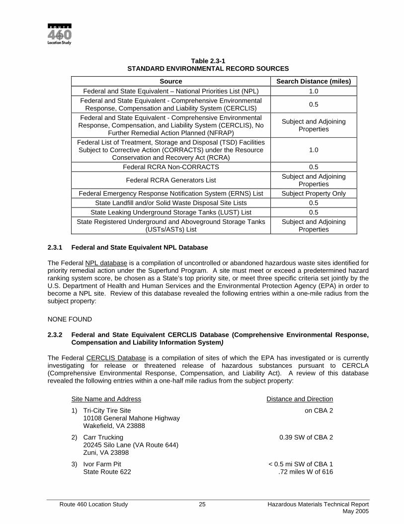
2.3 STANDARD ENVIRONMENTAL SOURCES
Information from the following standard environmental record sources, as specified by ASTM Practice E 1527-00, was provided by InfoMap Technologies. Any incident or facility identified within its approximate minimum search distance is, by definition, a REC (ASTM Section 1.1.1). These records were reviewed and mapped to identify past activities that could potentially result in RECs at the subject property or within an "approximate minimum search distance", as specified in ASTM Practice E 1527-00.
Table 2.3-1 contains the names and/or locations of reported hazardous waste sites, treatment, storage and disposal facilities, pollution and hazardous waste spills (including LUSTs) and landfills in Virginia. The database information provided by InfoMap Technologies identified the following entries within their specified search distance from the subject property.
Route 460 Location Study 25 Hazardous Materials Technical Report May 2005
Table 2.3-1 STANDARD ENVIRONMENTAL RECORD SOURCES
Source Search Distance (miles) Federal and State Equivalent – National Priorities List (NPL) 1.0
Federal and State Equivalent - Comprehensive Environmental Response, Compensation and Liability System (CERCLIS) 0.5
Federal and State Equivalent - Comprehensive Environmental Response, Compensation, and Liability System (CERCLIS), No
Further Remedial Action Planned (NFRAP)
Subject and Adjoining Properties
Federal List of Treatment, Storage and Disposal (TSD) Facilities Subject to Corrective Action (CORRACTS) under the Resource
Conservation and Recovery Act (RCRA) 1.0
Federal RCRA Non-CORRACTS 0.5
Federal RCRA Generators List Subject and Adjoining Properties
Federal Emergency Response Notification System (ERNS) List Subject Property Only State Landfill and/or Solid Waste Disposal Site Lists 0.5
State Leaking Underground Storage Tanks (LUST) List 0.5 State Registered Underground and Aboveground Storage Tanks
(USTs/ASTs) List Subject and Adjoining
Properties
2.3.1 Federal and State Equivalent NPL Database
The Federal NPL database is a compilation of uncontrolled or abandoned hazardous waste sites identified for priority remedial action under the Superfund Program. A site must meet or exceed a predetermined hazard ranking system score, be chosen as a State’s top priority site, or meet three specific criteria set jointly by the U.S. Department of Health and Human Services and the Environmental Protection Agency (EPA) in order to become a NPL site. Review of this database revealed the following entries within a one-mile radius from the subject property:
NONE FOUND
2.3.2 Federal and State Equivalent CERCLIS Database (Comprehensive Environmental Response, Compensation and Liability Information System)
The Federal CERCLIS Database is a compilation of sites of which the EPA has investigated or is currently investigating for release or threatened release of hazardous substances pursuant to CERCLA (Comprehensive Environmental Response, Compensation, and Liability Act). A review of this database revealed the following entries within a one-half mile radius from the subject property:
Site Name and Address Distance and Direction
1) Tri-City Tire Site on CBA 2 10108 General Mahone Highway Wakefield, VA 23888
2) Carr Trucking 0.39 SW of CBA 2 20245 Silo Lane (VA Route 644) Zuni, VA 23898
3) Ivor Farm Pit < 0.5 mi SW of CBA 1 State Route 622 .72 miles W of 616

Route 460 Location Study 26 Hazardous Materials Technical Report May 2005
Ivor, VA 23866
4) Sussex County Tire Fire CBA 1, 2 and/or 3 Route 460 Wakefield, VA 23888
5) Swift Agri Chem Corp. CBA 1, 2, and/or 3 Box 1609 Suffolk, VA 23434
Removal and a removal assessment was completed for Facility number 1. Facilities numbered 2, 3, 4 and 5 have a status of “No Further Remedial Action Planned (NFRAP)”. Therefore, it appears that none of the above listed facilities represent a source of impairment to the subject property.
2.3.3 Federal CORRACTS (Resource Conservation and Recovery Act Information System Corrective Action Sites) Database
The Federal CORRACTS Database is a compilation of treatment, storage or disposal facilities, which are subject to corrective action pursuant to RCRA Section 3008 (h), where there has been a release of hazardous waste or constituents into the environment from a RCRA facility. A review of these databases revealed the following entries within a one mile radius from the subject property:
Site Name and Address Distance and Direction
1) Boehringer Ingleheim Chemicals Inc. 0.99 SW of CBA 3 2820 North Normandy Drive Petersburg, VA 23805
2) Nevamar Co LLC 0.40 mi N of CBA 1 721 West Main Street 0.80 mi S of CBA 2 Waverly, VA 23890
3) MR Industries <1 mi CBA 1 Will Roy Industries PK Site 63 Suffolk, VA 23434
Facility number 1 manufactures pharmaceutical preparations and treats and stores hazardous materials, operates a land disposal facility and an incinerator. This facility has had numerous violations of their RCRA Permit, however, all violations have been resolved. Therefore, it does not appear that this facility represents a source of impairment to the subject property.
Facility number 2 manufactures wood products and is an RCRA treatment, storage, and disposal facility, which operates an incinerator and a land disposal facility. This facility has had several violations of their RCRA Permit, however, all violations have been resolved. Therefore, it does not appear that this facility represents a source of impairment to the subject property.
Facility number 3 is an RCRA non-CORRACTS site that operates a treatment, storage and disposal facility. There are no violations listed for this facility. Therefore, it does not appear that this facility represents a source of impairment to the subject property.
2.3.4 Federal RCRA Generators Database
The Federal RCRA Generators database is a compilation of facilities, which report the generation of hazardous waste (large or small quantity generators). Small quantity generators are classified as facilities, which generate between 100 kilograms (kg) and 1,000 kg per month of hazardous waste, or meet other applicable requirements of RCRA. Large quantity generators generate more than 1,000 kg per month, or
Route 460 Location Study 27 Hazardous Materials Technical Report May 2005
meet other requirements of RCRA. A review of this database revealed the following entries within the subject and adjoining properties:
Site Name and Address Distance and Direction
1) Seiberts 460 Texaco Truck Stop on CBA 2 7201 County Drive Disputanta, VA23842
2) B& D Body Shop Inc. on CBA 2 5112 County Drive Disputanta, VA 23842
3) Borden Chem, Inc. on CBA 2 5090 General Mahone Hwy. Waverly, VA 23890
4) Carrolls Foods of Virginia, Inc. on CBA 2 HWY 460 West Waverly, VA 23890 on CBA 2
5) Tidewater Petroleum on CBA 2 9242 Windsor Blvd. Windsor, VA 23487
6) East Coast Oil #58 on CBA 2 4707 County Drive Disputanta, VA 23842
7) Georgia-Pacific Corp on CBA 2 US Hwy 460 Wakefield, VA 23888
Facility number 1 above is a Small Quantity Generator and no violations have been found in association with it. Therefore, it does not appear that this facility represents a source of impairment to the subject property.
Facility numbers 2-7 are Conditionally Exempt Small Quantity Generators and no violations have been found in association with these facilities. Therefore, it does not appear that these facilities represent a source of impairment to the subject property.
2.3.5 Federal ERNS (Emergency Response Notification System) List
The Federal ERNS database is maintained by the Environmental Protection Agency (EPA) and contains information of reported CERCLA hazardous substances releases or spills in quantities greater than the reportable quantity, as maintained by the National Response Center. This information is compiled from reports made to the EPA, U.S. Coast Guard, National Response Center and/or the U.S. Department of Transportation. A review of this database revealed the following entries within the subject property:
Site Name and Address Distance and Direction
1) Thomas Wright on CBA 1 9584 Bear Trap Road Windsor, VA 23487
2) State Route 460 East on CBA 2 Wakefield, VA 23888
3) Plant Food Products on CBA 2 3460 General Mahone Blvd.
Route 460 Location Study 28 Hazardous Materials Technical Report May 2005
Ivor, VA 23866
4) Food Lion on CBA 2 6500 Enterprise Drive Disputanta, VA 23842
The ERNS at facility number 1 was caused by a leaking UST, which, according to the database has been leaking waste oil and lubricants for years. The leak affected the soil, the Black River and surrounding wetlands. Therefore, this facility may represent a source of impairment to the subject property.
Trinity Tire Company was the responsible party for the ERNS at facility number 2 above. Several 55-gallon drums of flammable solvents and paints were found to be leaking at an abandoned facility. The drums were stabilized, overpacked and removed from the facility. Therefore, it does not appear that this facility represents a source of impairment to the subject property.
The ERNS at facility number 3 above occurred when an AST valve burst and spilled 1,000 gallons of liquid ammonia to the surrounding land. Ninety-eight percent of the spilled ammonia was recovered. Therefore, it does not appear that this facility represents a source of impairment to the subject property.
Numerous ERNS have been reported at facility number 4 above. None of the ERNS have affected surface water bodies or groundwater and all of them were properly cleaned up. Therefore, it does not appear that this facility represents a source of impairment to the subject property.
2.3.6 State Landfill and/or Solid Waste Disposal Site Lists
The State landfills or solid waste disposal database is maintained by the Virginia Department of Environmental Quality (VDEQ) and contains the names and locations of solid waste landfills, incinerators and/or transfer stations. A review of this database revealed the following entries within a one-half mile radius from the subject property:
Site Name and Address Distance and Direction
1) SPSA Ivor Transfer Station on CBA 2 Ivor, VA 23866
2) Gray Lumber Company CBA 1, 2, and/or 3 Main Street Waverly, VA 23890
3) Nottoway County Landfill CBA 1, 2, and/or 3 Waverly, VA 23890
4) Southampton County Landfill – Ivor #2 CBA 1, 2, and/or 3 Ivor, VA 23866
5) Suffolk City Landfill CBA 1, 2, and/or 3 Hozier Road Suffolk, VA 23434
6) Butler Campground 0.44 NE of CBA 3 Windsor, VA 23487
Facility number 1 has an active permit to operate as a transfer station. Household waste it brought to the facility and is then taken to a landfill. Based on the nature of this facility, it does not appear to represent a source of impairment to the subject property.
Facility number 2 was permitted as an industrial waste landfill in 1977 and closed in 1984. Therefore, it does not appear that this facility represents a source of impairment to the subject property.

Route 460 Location Study 29 Hazardous Materials Technical Report May 2005
Facility number 3 was permitted in 1978 as a sanitary landfill. The facility is currently closed. Based on its status, it does not appear that this facility represents a source of impairment to the subject property.
Facility number 4 was permitted in 1982 as a sanitary landfill. The landfill closed in 1989 and the owner is currently seeking to end post closure monitoring. Therefore, it does not appear that this facility represents a source of impairment to the subject property.
Facility number 5 was permitted in 1980 as a sanitary landfill. The landfill is no longer accepting waste and is in the process of being closed. Based on its status, it does not appear that this facility represents a source of impairment to the subject property.
Facility number 6 was permitted in 1971 and stopped accepting waste in 1978. This facility is closed. Based on its status and the fact that this facility ceased operation over 20 years ago, it does not appear that this facility represents a source of impairment to the subject property.
2.3.7 State LUST (Leaking Storage Tank) List
The LUST database, maintained by the VDEQ, contains information on all known or suspected LUSTs in the State. Review of this database revealed the following entries within a one half-mile radius from the subject property:
Site Name and Address Distance and Direction
1) Rollings, Mary Estate 0.38 miles N of CBA 3 1084 White Marsh Road Wakefield, VA 23888
2) Waverly State Police 0.48 miles SW of CBA 3 438 E Main Street Waverly, VA 23890
3) Holiday Inn 0.01 miles NE of CBA 1 2864 Pruden Boulevard Suffolk, VA 23434
4) Sentry Food Mart #8 0.01 miles NE of CBA 1 2865 Pruden Boulevard Suffolk, VA 23434
5) Wright Dredging Co. Inc. 0.03 miles S of CBA 1 9584 Beartrap Circle Windsor, VA 23487
6) Triangle Market Former 0.07 miles NE of CBA 1 4605 County Drive Disputanta, VA 23842
7) Williams Jesse L Jr 0.03 miles NW of CBA 2 2925 Pruden Boulevard Suffolk, VA 23434
8) East Coast #58 on CBA 2 Mapco Express 4707 County Drive Petersburg, VA 23805
9) Mount Zion Elementary School 0.31 miles NE of CBA 1 3264 Pruden Boulevard Suffolk, VA 23434
Route 460 Location Study 30 Hazardous Materials Technical Report May 2005
10) Glenn Martin Chevrolet/Chrysler 0.35 miles NE of CBA 1 2584 Pruden Boulevard Suffolk, VA 23434
11) Aston Property 0.40 miles NE of CBA 1 Kings Fork Road and Pruden Boulevard Suffolk, VA 23434
12) Sentry Food Mart #52 0.40 miles NE of CBA 1 24 W Windsor Boulevard Windsor, VA 23487
13) Berle Real Estate LLC 0.41 miles NE of CBA 1 57 W Windsor Boulevard Windsor, VA 23487
14) Dixie Guano 0.45 miles NE of CBA 1 37 Windsor Boulevard Windsor, VA 23487
15) Hollands Mini Mart 0.45 miles NE of CBA 1 Routes 460 & 604 Suffolk, VA 23434
16) Georgia Pacific 0.47 miles NE of CBA 1 10242 General Mahone Hwy. Wakefield, VA 23888
17) 7 Eleven 21468 on CBA 2 Route 460 Waverly, VA 23890
18) Community Oil CBA 1, 2, and/or 3 Highway 40 Wakefield, VA 23888
19) GTE Facility 0.5 miles NE CBA 1 and SW of CBA 2 High Street Wakefield, VA 23888
20) Seberas Country Store CBA 1, 2, and/or 3 Route 106 Prince George, VA 23875
21) Sussex Bulk Oil Facility 0.5-1.0 miles SW of CBA 2 Route 460 & 714 Wakefield, VA 23888
22) West Main Street Pump Station CBA 1, 2, and/or 3 West Main Street Waverly, VA23890
23) Food Lion Distribution Center 2 on CBA 2 6500 Enterprise Drive Disputanta, VA 23842
24) Julian Adams 0.01 miles NE of CBA 2 Highway 460 Waverly, VA 23890
25) Country Classics 0.12 miles SW of CBA 2 6103 Country Drive Disputanta, VA 23842
Route 460 Location Study 31 Hazardous Materials Technical Report May 2005
26) Waverly State Police 0.31 miles SW of CBA 2 438 E Main Street Waverly, VA 23890
27) Aston Property 0.41 miles NE of CBA 2 Kings Fork Road and Pruden Boulevard Suffolk, VA 23434
28) Scarboro Darrell Residence 0.43 miles NE of CBA 2 105 N Beaverdam Road Waverly, VA 23890
29) Eley Mary Residence unmapped (CBA 1) 22507 Courthouse Way Windsor, VA 23847
30) Gray Lumber Company unmapped (CBA 1) Main Street Waverly, VA 23890
31) Larison Barbara Residence 0.38 miles SW of CBA 2 38207 General Mahone Blvd Ivor, VA 23866
The LUST cases at facility numbers 1, 2, 3, 5, 6, 7, 9, 10, 11, 12, 13, 14, 15, 16, 17, 18, 19, 20, 22, 23, 24, 25, 26, 27, 28, 29, 30 and 31 have been closed by VDEQ. Therefore, it does not appear that these facilities represent a source of impairment to the subject property.
The LUST cases at facility numbers 4 (PC #99-2304), 8 (PC #03-4333) and 21 (PC #94-1954) each have open VDEQ cases. Therefore, these LUSTs may represent a source of impairment to the subject property.
2.3.8 State Registered UST/AST (Underground Storage Tank/Above Ground Storage Tank) List
Underground and aboveground storage tanks regulated under Subtitle I of RCRA must be registered with the State agency responsible for administering the UST program. In Virginia, the Department of Environmental Quality maintains the database of all registered USTs in the State. Review of the UST database revealed the following entries within the subject and adjoining properties.
Site Name and Address Distance and Direction
1) Carr Trucking on CBA 2 Hwy 460 Zuni, VA 23898
2) Zuni Amoco on CBA 2 Rt. 460 Zuni, VA 23898
3) Zuni Peanut Company on CBA 2? Rt. 460 Zuni, VA 23898
4) Disputanta Fire House on CBA 2 1000 County Drive Prince George, VA 23875
5) Scotts Plant 1505 on CBA 2 8101 General Mahone Hwy Wakefield, VA 23888
Route 460 Location Study 32 Hazardous Materials Technical Report May 2005
6) Seiberts 460 Texaco Truck Stop on CBA 2 7201 County Drive Disputanta, VA 23842
7) Carroll’s Food Feed Mill 0.01 miles SW of CBA 2 27404 General Mahone Hwy. Waverly, VA 23890
8) Southern States Tidewater Petroleum 0.01 miles SW of CBA 2 9242 Windsor Boulevard Windsor, VA 23487
9) Spurlock Adhesives Inc. 0.01 miles SW of CBA 2 5090 General Mahone Hwy Waverly, VA 23890
10) John’s Auto Body & Painting 0.02 miles SW of CBA 2 4216 General Mahone Hwy. Waverly, VA 23890
11) Van Cleef Auto Parts and Trucking 0.02 miles SW of CBA 2 5556 General Mahoney Hwy. Waverly, VA 23890
12) McLean Toms Inc. 0.03 miles NE of CBA 2 Petersburg, VA 23875
13) Southside Ford Tractor Inc. 0.03 miles NE of CBA 2 Highway 460 E Petersburg, VA 23842
14) Pine Pasture Farm 0.03 miles NW of CBA 2 2925 Pruden Boulevard Suffolk, VA 23434
15) PB/Sussex Communications Tower 0.04 miles SW of CBA 2 Route 460 Graves, VA 23890
16) Moore Junior High School 0.06 miles SW of CBA 2 1103 Prince George Drive Prince George, VA 23875
17) Holiday Inn 0.01 miles NE of CBA 1 2864 Pruden Blvd Suffolk, VA 23434
18) Sentry Food Mart #8 0.01 miles NE of CBA 1 2865 Pruden Boulevard Suffolk, VA 23434
19) Wright Dredging Co. Inc. 0.03 miles S of CBA 1 9584 Beartrap Circle Windsor, VA 23487
20) East Coast #58 on CBA 2
Mapco Express 4707 County Drive Petersburg, VA 23805
21) Bank of Isle of Wight unmapped CBA 2 Route 460
Route 460 Location Study 33 Hazardous Materials Technical Report May 2005
Wakefield, VA 23888
22) Beale Boys unmapped Route 40 Waverly, VA 23890
23) Brandon Plantation unmapped 23105 Brandon Road Spring Grove, VA 23881
24) Britts Wakefield Shell unmapped Highway 460 Wakefield, VA 23888
25) Cavalier Quick Stop unmapped Highway 460 Waverly, VA 23890
26) Chips Market unmapped Highway 460 Waverly, VA 23890
27) Clantons Electric unmapped Main Strreet Waverly, VA 23890
28) Cobbs Automotive unmapped Route 760 Wakefield, VA 23888
29) DL Magee unmapped Waverly, VA 23890
30) East End Service unmapped W Main Street Waverly, VA 23890
31) Express Mart #4 unmapped Route 40 W Waverly, VA 23890
32) Former Harrups Supermarket unmapped Ivor Road Ivor, VA 23866
33) Gladys Walker unmapped Country Drive Disputanta, VA 23842
34) Goodman and Holland unmapped Route 610 Windsor, VA 23487
35) Gray Lumber Company unmapped Main Street Waverly, VA 23890
36) HW Wade unmapped Highway 616 Ivor, VA 23866
37) Hilltop Truck Stop unmapped Route 460

Route 460 Location Study 34 Hazardous Materials Technical Report May 2005
Ivor, VA 23866
38) JE Nash and Son unmapped Route 460 Ivor, VA 23866
39) JR Andrews Farm unmapped Highway 617 Wakefield, VA 23888
40) James T Jones unmapped Route 2 Box 50 Windsor, VA 23487
41) John D Nurney unmapped Route 3 Box 106 Windsor, VA 23487
42) John D Crocker unmapped Route 2 Box 163 Ivor, VA 23866
43) LA Brantly Farm unmapped Highway 616 Ivor, VA 23866
44) L Frank Byrum Jr unmapped Route 2 Box 2663 Windsor, VA 23487
45) Lanier Felix B unmapped Main Street Wakefield, VA 23888
46) Larry Lee Neave Farm unmapped Route 1 Box 86 Ivor, VA 23866
47) Leonards unmapped Route 460 Ivor, VA 23866
48) Midway Chevron unmapped Route 460 Wakefield, VA 23888
49) Mike Spain; Nottoway Farms unmapped Jerusalem Plank Road Waverly, VA 23890
50) Oberry Farm Supply unmapped Route 3 Box 100 Windsor, VA 23487
51) Padgett Brothers unmapped Waverly, VA 23890
52) Prince George Emergency Crew Building unmapped Prince George Dr Prince George, VA 23875
53) Rolley Firewood Sales unmapped Country Drive W

Route 460 Location Study 35 Hazardous Materials Technical Report May 2005
Disputanta, VA 23842
54) Royster Clark unmapped 611 Factory Street Windsor, VA 23487
55) SS Kea and Son unmapped Route 460 Ivor, VA 23866
56) SP Roeder unmapped Highway 460 W Waverly, VA 23890
57) Scott Truck Lot unmapped Route 258 S Windsor, VA 23487
58) Stanley Turner unmapped Route 3 Box 62 Windsor, VA 23487
59) Stephenson Farms unmapped Highway 628 Wakefield, VA 23888
60) Sussex Farm Equipment unmapped Highway 460 E Waverly, VA 23890
61) Tidewater Farm and Garden Supply unmapped PO Box 147 Windsor, VA 23487
62) Wagon Wheel unmapped Highway 460 Ivor, VA 23866
63) Wakefield Chevron unmapped 555 County Drive Wakefield, VA 23888
64) Wakefield Texaco unmapped Highway 460 Wakefield, VA 23888
65) Windsor Truckstop unmapped Route 460 Windsor, VA 23487
66) Woodys Chevron unmapped Route 460 Wakefield, VA 23888
67) Ye Old Tobacco Shop unmapped Route 460 Windsor, VA 23487
68) GTE Wakefield Facility unmapped High Street Wakefield, VA 23888
69) Ivor Furniture Company unmapped
Route 460 Location Study 36 Hazardous Materials Technical Report May 2005
Route 460 Ivor, VA 23866
70) Windsor Shell unmapped Windsor Blvd Windsor, VA 23487
71) Windsor Peanut Company unmapped Route 460 Windsor, VA 23487
72) Windsor Inn unmapped Route 460 Windsor, VA 23487
73) VDOT Windsor AHQ unmapped 22516 Buckhorn Drive Windsor, VA 23487
74) Country Classics 0.12 miles SW of CBA 2 6103 Country Drive Disputanta, VA 23842
75) Windsor Elementary School 0.11 miles SW of CBA 2 23320 North Court Street Windsor, VA 23487
76) Prince George Golf 0.11 miles SW of CBA 2 8401 Golf Course Drive Prince George, VA 23842
77) Waverly Health Care 0.08 miles NE of CBA 2 456 E Main Street Waverly, VA 23890
78) Harrison Elementary School 0.07 miles SE of CBA 2 2900 E Quaker Rd Prince George, VA 23875
79) Virginia State Police 0.07 miles NW of CBA 2 2900 Pruden Blvd Suffolk, VA 23434
80) Petersburg Jail Farm 0.06 miles NE of CBA 2 6104 County Drive Disputanta, VA 23842
81) Georgia Pacific 0.01 miles SW of CBA 2 10242 General Mahone Hwy Wakefield, VA 23888
82) Food Lion Distribution Ctr 2 CBA 2 10242 General Mahone Hwy Wakefield, VA 23888
83) Community Oil CBA 2 9243 General Mahone Hwy Waverly, VA 23890
Facility number 1 above has three 1,000-gallon diesel USTs, which are currently in use and six, which were removed. These active USTs are bare steel and were installed in 1976. Based on the age and construction of the USTs, this facility may represent a source of impairment to the subject property.
Route 460 Location Study 37 Hazardous Materials Technical Report May 2005
Facility number 2 above has three 2,000-gallon gasoline USTs which have been closed in the ground. Therefore, it does not appear that this facility represents a source of impairment to the subject property.
Facility number 3 has three 3,000-gallon gasoline USTs which have been removed from the ground. Therefore, it does not appear that this facility represents a source of impairment to the subject property.
Facility number 4 has one 550 gallon gasoline UST which is currently in use. Therefore, it does not appear that this facility represents a source of impairment to the subject property.
Facility number 5 has two USTs which are currently in use. Therefore, it does not appear that the USTs at this facility represent a source of impairment to the subject property.
Facility number 6 has three USTs currently in use and six USTs which were removed from the ground. Therefore, it does not appear that the USTs at this facility represent a source of impairment to the subject property.
Facility number 7 has three USTs currently in use. Therefore, it does not appear that the USTs at this facility represent a source of impairment to the subject property.
Facility number 8 has seven USTs currently in use, six USTs permanently out of use, and three USTs which were removed from the ground. Therefore, it does not appear that the USTs at this facility represent a source of impairment to the subject property.
Facility number 9 has three ASTs which are currently in use. Therefore, it does not appear that this facility represents a source of impairment to the subject property.
Facility number 10 has three USTs which have been removed from the ground. Therefore, it does not appear that the USTs at this facility represents a source of impairment to the subject property.
Facility number 11 has two USTs currently in use and two USTs which have been removed from the ground. Therefore, it does not appear that this facility represents a source of impairment to the subject property.
Facility number 12 has one UST which has been closed in the ground. Therefore, it does not appear that this facility represents a source of impairment to the subject property.
Facility number 13 has one UST which has been removed from the ground. Therefore, it does not appear that the UST at this facility represents a source of impairment to the subject property.
Facility number 14 has five USTs which have been removed from the ground. Therefore, it does not appear that this facility represents a source of impairment to the subject property.
Facility number 15 has one UST which has been removed from the ground. Therefore, it does not appear that the UST at this facility represents a source of impairment to the subject property.
Facility number 16 has one UST which is currently in use and one UST which has been removed from the ground. Therefore, it does not appear that the USTs at this facility represent a source of impairment to the subject property.
Facility number 17 has one 10,000-gallon heating oil UST which has been removed from the ground. Therefore, it does not appear that this facility represents a source of impairment to the subject property.
Route 460 Location Study 38 Hazardous Materials Technical Report May 2005
Facility number 18 has four fuel USTs in use and two 10,000-gallon diesel USTs which have been removed from the ground. Therefore, it does not appear that the USTs at this facility represent a source of impairment to the subject property.
Facility number 19 has one UST closed in the ground. Therefore, it does not appear that the UST at this facility represent a source of impairment to the subject property.
Facility number 20 has six USTs currently in use. Therefore, it does not appear that the USTs at this facility represent a source of impairment to the subject property.
Facility number 21 has one UST currently in use. Therefore, it does not appear that the UST at this facility represent a source of impairment to the subject property.
Facility number 22 has one UST closed in the ground and four USTs which have been removed from the ground. Therefore, it does not appear that the USTs at this facility represent a source of impairment to the subject property.
Facility number 23 has six USTs currently in use. Therefore, it does not appear that the USTs at this facility represent a source of impairment to the subject property.
Facility number 24 has three USTs currently in use. Therefore, it does not appear that the USTs at this facility represent a source of impairment to the subject property.
Facility number 25 has four USTs currently in use. Therefore, it does not appear that the USTs at this facility represent a source of impairment to the subject property.
Facility number 26 has seven USTs currently in use and two closed in the ground. Therefore, it does not appear that the USTs at this facility represent a source of impairment to the subject property.
Facility number 27 has one UST which has been removed from the ground. Therefore, it does not appear that the UST at this facility represent a source of impairment to the subject property.
Facility number 28 has one UST currently in use and two closed in the ground. Therefore, it does not appear that the USTs at this facility represent a source of impairment to the subject property.
Facility number 29 has two USTs temporarily out of use. Therefore, it does not appear that the USTs at this facility represent a source of impairment to the subject property.
Facility number 30 has one 550-gallon bare steel kerosene UST currently in use. Based on its construction, the UST at this facility may represent a source of impairment to the subject property.
Facility number 31 has four USTs, three 8,000 gallon gasoline and one 4,000 gallon kerosene, currently in use. Therefore, it does not appear that the USTs at this facility represent a source of impairment to the subject property.
Facility number 32 has three USTs which were removed from the ground. Therefore, it does not appear that the USTs at this facility represent a source of impairment to the subject property.
Facility number 33 has five USTs which were closed in the ground. Therefore, it does not appear that the USTs at this facility represent a source of impairment to the subject property.
Facility number 34 has four USTs which are currently in use. Therefore, it does not appear that the USTs at this facility represent a source of impairment to the subject property.
Route 460 Location Study 39 Hazardous Materials Technical Report May 2005
Facility number 35 has nine USTs which were removed from the ground. Therefore, it does not appear that the USTs at this facility represent a source of impairment to the subject property.
Facility number 36 has three USTs which were removed from the ground. Therefore, it does not appear that the USTs at this facility represent a source of impairment to the subject property.
Facility number 37 has seven USTs which are currently in use. Therefore, it does not appear that the USTs at this facility represent a source of impairment to the subject property.
Facility number 38 has three USTs which are currently in use. Therefore, it does not appear that the USTs at this facility represent a source of impairment to the subject property.
Facility number 39 has two USTs which are currently in use. Therefore, it does not appear that the USTs at this facility represent a source of impairment to the subject property.
Facility number 40 has four USTs which are currently in use. Therefore, it does not appear that the USTs at this facility represent a source of impairment to the subject property.
Facility number 41 has three USTs which are currently in use. Therefore, it does not appear that the USTs at this facility represent a source of impairment to the subject property.
Facility number 42 has two USTs which are currently in use. Therefore, it does not appear that the USTs at this facility represent a source of impairment to the subject property.
Facility number 43 has one UST which is currently in use. Therefore, it does not appear that the UST at this facility represent a source of impairment to the subject property.
Facility number 44 has two USTs which are currently in use. Therefore, it does not appear that the USTs at this facility represent a source of impairment to the subject property.
Facility number 45 has one UST which is closed in the ground. Therefore, it does not appear that the UST at this facility represents a source of impairment to the subject property.
Facility number 46 has one UST which is currently in use. Therefore, it does not appear that the UST at this facility represents a source of impairment to the subject property.
Facility number 47 has two USTs which are currently in use. Therefore, it does not appear that the USTs at this facility represent a source of impairment to the subject property.
Facility number 48 has three USTs which are closed in the ground. Therefore, it does not appear that the USTs at this facility represent a source of impairment to the subject property.
Facility number 49 has two USTs which are currently in use. Therefore, it does not appear that the USTs at this facility represent a source of impairment to the subject property.
Facility number 50 has two USTs which are currently in use and one UST closed in the ground. Therefore, it does not appear that the USTs at this facility represent a source of impairment to the subject property.
Facility number 51 has three USTs which are temporarily out of use. Therefore, it does not appear that the USTs at this facility represent a source of impairment to the subject property.
Facility number 52 has one UST which is currently in use and one UST removed from the ground. Therefore, it does not appear that the USTs at this facility represent a source of impairment to the subject property.
Route 460 Location Study 40 Hazardous Materials Technical Report May 2005
Facility number 53 has one USTs which is closed in the ground. Therefore, it does not appear that the UST at this facility represents a source of impairment to the subject property.
Facility number 54 has one UST which was removed from the ground. Therefore, it does not appear that the USTs at this facility represent a source of impairment to the subject property.
Facility number 55 has one UST which is currently in use. Therefore, it does not appear that the UST at this facility represents a source of impairment to the subject property.
Facility number 56 has two USTs which were removed from the ground. Therefore, it does not appear that the USTs at this facility represent a source of impairment to the subject property.
Facility number 57 has two USTs which are currently in use. Therefore, it does not appear that the USTs at this facility represent a source of impairment to the subject property.
Facility number 58 has one UST which is closed in the ground. Therefore, it does not appear that the UST at this facility represents a source of impairment to the subject property.
Facility number 59 has four USTs which are currently in use. Therefore, it does not appear that the USTs at this facility represent a source of impairment to the subject property.
Facility number 60 has two USTs which were removed from the ground. Therefore, it does not appear that the USTs at this facility represent a source of impairment to the subject property.
Facility number 61 has three USTs which were removed from the ground. Therefore, it does not appear that the USTs at this facility represent a source of impairment to the subject property.
Facility number 62 has four USTs which are currently in use. Therefore, it does not appear that the USTs at this facility represent a source of impairment to the subject property.
Facility number 63 has five USTs which are currently in use. Therefore, it does not appear that the USTs at this facility represent a source of impairment to the subject property.
Facility number 64 has two USTs which were closed in the ground. Therefore, it does not appear that the USTs at this facility represent a source of impairment to the subject property.
Facility number 65 has five USTs which were closed in the ground. Therefore, it does not appear that the USTs at this facility represent a source of impairment to the subject property.
Facility number 66 has three USTs which were closed in the ground. Therefore, it does not appear that the USTs at this facility represent a source of impairment to the subject property.
Facility number 67 has one UST which was removed from the ground. Therefore, it does not appear that the USTs at this facility represent a source of impairment to the subject property.
Facility number 68 has one UST which was removed from the ground. Therefore, it does not appear that the UST at this facility represent a source of impairment to the subject property.
Facility number 69 has one UST which was removed from the ground. Therefore, it does not appear that the UST at this facility represents a source of impairment to the subject property.
Facility number 70 has five USTs which were removed from the ground. Therefore, it does not appear that the USTs at this facility represent a source of impairment to the subject property.
Route 460 Location Study 41 Hazardous Materials Technical Report May 2005
Facility number 71 has three USTs which were removed from the ground. Therefore, it does not appear that the USTs at this facility represent a source of impairment to the subject property.
Facility number 72 has four USTs which were removed from the ground. Therefore, it does not appear that the USTs at this facility represent a source of impairment to the subject property.
Facility number 73 has three USTs which are currently in use, one UST permanently out of use and one UST removed from the ground. Therefore, it does not appear that the USTs at this facility represent a source of impairment to the subject property.
Facility number 74 has one UST which is permanently out of use. Therefore, it does not appear that the UST at this facility represents a source of impairment to the subject property.
Facility number 75 has one UST which is closed in the ground. Therefore, it does not appear that the UST at this facility represents a source of impairment to the subject property.
Facility number 76 has one UST which is closed in the ground. Therefore, it does not appear that the UST at this facility represents a source of impairment to the subject property.
Facility number 77 has one UST which was removed from the ground. Therefore, it does not appear that the UST at this facility represents a source of impairment to the subject property.
Facility number 78 has one UST which was removed from the ground. Therefore, it does not appear that the UST at this facility represents a source of impairment to the subject property.
Facility number 79 has one UST which is currently in use and one UST which was removed from the ground. Therefore, it does not appear that the USTs at this facility represent a source of impairment to the subject property.
Facility number 80 has two USTs which are currently in use. Therefore, it does not appear that the USTs at this facility represent a source of impairment to the subject property.
Facility number 81 has five USTs which are currently in use and one UST closed in the ground. Therefore, it does not appear that the USTs at this facility represent a source of impairment to the subject property.
Facility number 82 has one USTs which is currently in use and five USTs removed from the ground. Therefore, it does not appear that the USTs at this facility represent a source of impairment to the subject property.
Facility number 83 has one USTs which is currently in use and one UST closed in the ground. Therefore, it does not appear that the USTs at this facility represent a source of impairment to the subject property.
(This area left blank intentionally)
Route 460 Location Study 42 Hazardous Materials Technical Report May 2005
3.0 SITE RECONNAISSANCE
3.1 METHODOLOGY
Visual inspections of the subject property and adjoining property occurred on June 21, 23, and July 1, 2004. Information obtained through prior review of reasonably ascertainable, practically reviewable, standard historical, physical setting and environmental record sources and interviews was compiled and used as a field guide during the on-site reconnaissance of the subject property. The subject and adjoining properties were viewed from public thoroughfares.
3.2 LIMITATIONS OF THE SITE RECONNAISSANCE
Limitations encountered on the subject property, which precluded a complete visual inspection of the subject property, included:
• Interior inspections were not conducted for the majority of the on-site buildings because of the residential and confidential nature of the project.
• Dense vegetation, parked vehicles, and privacy fences precluded a visual inspection of a majority of the property.
3.3 PAST AND CURRENT USES OF THE SUBJECT PROPERTY
The subject property consists of the area just east of Petersburg and extends to Suffolk, including the following localities: Disputanta, Waverly, Wakefield, Dendron, Ivor, Zuni and Windsor, a small northern portion of Suffolk, the majority of Isle of Wight, and western portions of Surry, Rushmere and Smithfield. The study area currently consists of primarily agricultural and residential tracts with some industrial and commercial property. Based on the aerial photography, it appears that 5%-10% of the study area is industrial and commercial. The densest development and the majority of commercial and industrial properties are located proximal to each of the localities. Several secondary roadways and waterways and one railway lie within the study area, as does U.S. 460. Three known airfields exist within the study area, including: Garner Airport landing strip (between Suffolk and Windsor), the Wakefield Municipal Airport and a landing strip between Waverly and Disputanta (just east of 460), and vacant land. Table 1 includes more detailed property descriptions. .
3.4 INTERIOR AND EXTERIOR OBSERVATIONS
3.4.1 General Description of Structures
The subject property currently contains numerous structures. Please refer to Table 1, for details on the use of these structures.
3.4.2 Roads and Parking Areas
The subject property can be accessed by Route 460 and intersecting Routes. The subject property contains numerous on-site parking areas in the vicinity of the on-site structures.
3.4.3 Hazardous Substances and Petroleum Products Containers
No hazardous substances were observed on the subject property during the on-site inspection. Petroleum products containers were observed on the subject property as noted above in Table 1.

Route 460 Location Study 43 Hazardous Materials Technical Report May 2005
3.4.4 Underground Storage Tanks (USTs) and Aboveground Storage Tanks (ASTs)
The USTs and ASTs observed on the subject property during the on-site inspection include those listed in Table 1. Of these, USTs which may represent a source of impairment to the subject property include those in Table 1 marked “Yes” in the last column.
3.4.5 Polychlorinated Biphenyls (PCBs)
Numerous electrical transformers, the majority of which are pole-mounted, were observed on the subject property during the on-site inspection. Of these electrical transformers observed, none were labeled with “Non-PCB containing labels”, however no evidence of leaks or spills was observed in their vicinity. Therefore, these electrical transformers are not believed to represent a source of impairment to the subject property.
3.4.6 Solid Waste
Solid waste was observed on the subject property at the time of the on-site inspection at the SPSA Ivor transfer station as well as along the roadside at many residences.
3.4.7 Pools of Liquid
No pools of liquid were observed within the subject property during the on-site inspection.
3.4.8 Odors
Petroleum odors were detected on the subject property at the time of the on-site inspection at the Cavalier Quick Stop former gas station on Route 460. The petroleum odors and two vent pipes observed at the structure indicate that this REC may represent a source of impairment to the subject property.
3.4.9 Stained Soil or Pavement
No stained soil was observed within the subject property during the on-site inspection.
3.4.10 Stressed Vegetation
Stressed vegetation was observed within the subject property during the on-site inspection at the following locations:
• Cavalier Quick Stop (former gas station) on Route 460. The stressed vegetation, petroleum odors and two vent pipes indicate that this REC may represent a source of impairment to the subject property.
• Texaco Gas Station on Route 460 (in Waverly). The stressed vegetation, three USTs, several stored ASTs (area where the stressed vegetation exists), and two monitoring wells indicate that this REC may represent a source of impairment to the subject property.
3.4.11 Stormwater and Wastewater
Stormwater on-site is allowed to flow via overland flow toward on-site and adjacent ditches and curb drop inlets. Wastewater generated on-site within the larger more populated areas is transported via sanitary sewer lines to local wastewater treatment plants, such as the Rural Wastewater Systems (west of Route 29; 128/Route 460) or the Hampton Roads Sanitation District from the Suffolk area. Based on the field inspection, septic systems are located at many of the residential properties.
Route 460 Location Study 44 Hazardous Materials Technical Report May 2005
3.4.12 Pits, Ponds or Lagoons
No pits or ponds were observed on the subject property during the on-site inspection. Lagoons associated with hog farms were observed adjacent to the subject property during the on-site inspection.
3.4.13 Wells
Wells were observed at several residences on the subject property at the time of the on-site inspection.
3.4.14 Interior Utilities and Equipment
The interiors of buildings were not inspected during the on-site inspection; therefore, the condition of interior utilities and equipment is unknown.
3.5 CURRENT LAND USES OF ADJOINING PROPERTIES
The subject property is bound by the City of Petersburg to the west, the City of Suffolk to the east, and the Counties of Prince George, Surry, Sussex, Surry, Southampton and Isle of Wight to the north, and the Counties of Prince George, Surry, Sussex, Southampton and Isle of Wight to the south.
Route 460 Location Study 45 Hazardous Materials Technical Report May 2005
4.0 INTERVIEWS
Interviews were conducted with the following individuals:
• Mr. Bill Richardson, Resident Engineer, VDOT Waverly Residency
• Walter Green, Director of Planning and Zoning, Sussex County
A summary of these interviews is as follows:
• Mr. Richardson stated that he believed most service stations had replaced their storage tanks, but that the Waverly Residency has monitoring wells that a consultant checks weekly. He further stated that Prince George Electric, adjacent the residency, may have storage tanks and that there is a former service station at Route 602. He was unaware of any other indication of hazardous materials along the proposed CBAs, except for service stations and those stated.
• Mr. Green stated that he has no knowledge of hazardous material or petroleum releases along the proposed CBAs. He further stated that his primary concerns with the proposed project were wetlands impacts and economic impacts to towns.
Route 460 Location Study 46 Hazardous Materials Technical Report May 2005
5.0 REFERENCES
American Society for Testing and Materials, (2000). ASTM Standards on Environmental Assessments for Commercial Real Estate, Third Edition Standard Practice for Environmental Site Assessments: Phase I Environmental Site Assessment Process, E 1527-00.
U. S. D. A., (1986). Soil Conservation Service Soil Survey of Isle of Wight County, Virginia
U. S. D. A., (1981). Soil Conservation Service Soil Survey of City of Suffolk, Virginia
U. S. D. A., (1986). Soil Conservation Service Soil Survey of Southampton County, Virginia
U. S. D. A., (1986). Soil Conservation Service Soil Survey of Surry County, Virginia
U. S. D. A., (1986). Soil Conservation Service Soil Survey of Sussex County, Virginia
U. S. G. S., (1965, photorevised 1980). Chuckatuck Quadrangle 7.5 Minute Topographic Map, 1:24,000.
U. S. G. S., (1969, photorevised 1990). Disputanta North Quadrangle 7.5 Minute Topographic Map, 1:24,000.
U. S. G. S., (1968, photorevised 1981). Disputanta South Quadrangle 7.5 Minute Topographic Map, 1:24,000.
U. S. G. S., (1968, photorevised 1981). Ivor Quadrangle 7.5 Minute Topographic Map, 1:24,000.
U. S. G. S., (1969). Manry Quadrangle 7.5 Minute Topographic Map, 1:24,000.
U. S. G. S., (1969, photorevised 1990). Prince George Quadrangle 7.5 Minute Topographic Map, 1:24,000.
U. S. G. S., (1968). Raynor Quadrangle 7.5 Minute Topographic Map, 1:24,000.
U. S. G. S., (1969, photorevised 1974). Templeton Quadrangle 7.5 Minute Topographic Map, 1:24,000.
U. S. G. S., (1969, photorevised 1990). Waverly Quadrangle 7.5 Minute Topographic Map, 1:24,000.
U. S. G. S., (1965, photorevised 1980). Windsor Quadrangle 7.5 Minute Topographic Map, 1:24,000.
U. S. G. S., (1969, photorevised 1980). Zuni Quadrangle 7.5 Minute Topographic Map, 1:24,000.
Virginia Division of Mineral Resources, (1993). Geologic Map of Virginia, scale 1:500,000.
Virginia Water Control Board, (1985). Ground Water Map of Virginia,
Information Bulletin 560, Scale 1:1,000,000.