Embed Size (px)
Citation preview
Statement of Significance
Cârnic Massif, RoΊia Montană, jud Alba Romania
Prof Andrew Wilson Prof David Mattingly Michael Dawson FSA MIfA
September 2010 with additional summary July 2011

Statement of Significance Roúia Montană, Cărnic Massif
2 MD/12092
This Statement of Significance has been written by Professor Andrew Wilson, University of Oxford, Institute of Archaeology and Professor David Mattingly, of the University of Leicester, School of Archaeology and Ancient History. The project was managed by Michael Dawson FSA MifA, Director of CgMs Consultancy Ltd. The contents of the report reflect the views of the three authors ©. No part of this report is to be copied in any way without prior written consent. Every effort is made to provide detailed and accurate information, however, the Universities of Oxford, Leicester and CgMs cannot be held responsible for errors or inaccuracies within this report.

Statement of Significance Roúia Montană, Cărnic Massif
3 MD/12092
CONTENTS
Preface
Executive Summary
1.0 Introduction
2.0 Statement of Significance
3.0 The Significance of Specific Attributes
4.0 The Significance of Historic Processes
5.0 Bibliography

Statement of Significance Roúia Montană, Cărnic Massif
4 MD/12092
LIST OF ILLUSTRATIONS
Fig 1 Roman Roúia Montană
Fig 2 The Cetate opencast, seen from the Cârnic Massif
Fig 3 Entrances to the ancient mine galleries at Găuri
Fig 4 The Roman circular mausoleum at Tău Găuri, in its temporary cover building
Fig 5 The Cârnic massif seen from Roúia Montană
Fig 6 The modern village of Corna and, in the background from left to right, waste from the
Cetate opencast; Cârnicel; and the Cârnic massif. The proposed mining project would
raze much of the Cârnic massif to about the level of the top of the Cetate waste spills,
and bury the site of Corna village under the tailings facility to the level of the bottom of
the spire of the church on the left, and the base of the church on the right.
Fig 7 Tăul Cornei, an early modern header pond for ore-crushing machinery, seen from Piatra
Corbului. The Roman necropolis lay just beyond the pond.
Fig 8 Entrances to modern mine galleries in the Jig-Văidoaia massif.
Fig 9 Ore-crushing technology - the stamp mills of Rosia Montana and their predecessors:
a)Traditional stamp mill at the old Minvest mining museum of Rosia Montana; b) Woodcut
showing a stamp mill, from Georgius Agricola’s De Re Metallica, 1556; c) Roman anvil
stone from a stamp mill (Villamontan de la Valduerna, Spain); d) Anvil stone from a
traditional stamp mill, Roúia Montană.
Fig 10 Găuri - opencast working with a deep cut where a vein has been followed from the
surface.
Fig 11 Roman mine gallery with trapezoidal cross-section in the Cârnic massif.
Fig 12 Roman trapezoidal gallery in Păru Carpeni, with working marks on the walls and roof
showing how the gallery was advanced a few centimetres at a time.
Fig 13 Roman stepped descending gallery in the Cârnic massif.
Fig 14 Superimposed Roman galleries in the Orlea massif. (The bracing timbers are modern.)
Fig 15 Cârnic 10 - Roman working chamber
Fig 16 Cârnic - Roman exploitation chamber with basins (now flooded) cut in the floor.
Fig 17 Păru Carpeni - chamber for a wooden drainage wheel in the Roman mine network. The
wooden bearing block for the wheel axle is visible towards the top of the picture, and
Roman wooden shoring towards the bottom.
Fig 18 Shothole for explosive charge in the wall of an early modern mine gallery in the Cârnic
massif.
Fig 19 Communist-era transport gallery in the Cârnic massif.
Fig 20 Abandoned extraction machine in the Cetate opencast.
Fig 21 Communist era pillared exploitation chamber in the Cârnic massif.
Fig 22 Itinerary of visit of UK experts

Statement of Significance Roúia Montană, Cărnic Massif
5 MD/12092
APPENDICES
Appendix 1: Itinerary of visit of UK experts
Appendix 2: Roúia Montană and Other Roman Gold Mines
Appendix 3: Statements of Significance
Appendix 4: Letter of Endorsement from the Institute for Archaeologists

Statement of Significance Roúia Montană, Cărnic Massif
6 MD/12092
PREFACE
The Statement of Significance for Roúia Montană area was written (...) in a short time
frame of only two months, between August and September 2010. The authors
have placed the evidence at Roúia Montană in its international context. We have
also examined the area’s potential, noting other World Heritage Sites as they have
developed after inscription in the UNESCO list, to show that Roúia Montană has the
necessary significance and potential to become a World Heritage Site.
The report was re-issued in July 2011 with the addition of an extended Executive
Summary. This makes no material change to the report itself. It gathers together the
significance statements written for the principal areas of evidence investigated by
RMGC and examined during a three-day field visit in August 2011. The summary
does, however, emphasise the interrelationship of the evidence which highlights
Roúia Montană’s unique contribution to world culture. Not only is this region
important to history of the Roman Empire and the province of Dacia, but to the
development of gold mining in the Austro-Hungarian empire and later still during the
repressive years of the later 20th century. Gathering together site-specific
significances also emphasises the nature of investigation to date. The report
emphasises the significance of taking a landscape based approach to the heritage of
the Roúia Montană region. It also highlights important periods for which the
documentation is currently poor or non-existent, for instance, the transitions from
pre-Roman Dacia to Roman province, from Roman Dacia to early medieval
Transylvania, and later the high medieval and Austro-Hungarian periods.
Explicitly this document supports the protection of this landscape and the
conservation and enhancement of its outstanding universal value.

Statement of Significance Roúia Montană, Cărnic Massif
7 MD/12092
EXECUTIVE SUMMARY
This Statement of Significance, which focuses on the Cărnic Massif of Roúia Montană,
concludes that the Cărnic Massif constitutes part of a wider cultural landscape of high
significance, comparable in magnitude to “outstanding universal value” in the
UNESCO criteria for World Heritage status1. The evidence of Roman mining in Cărnic
is part of the largest, most extensive and most important underground mine
complexes within the Roman Empire. It is, in this important respect, unique.
The underground evidence of mining, galleries, adits and technology gains in
significance because it is associated with an historic landscape above ground with
evidence of processing, settlements, ritual and communities. Further evidence, from
epigraphy, wax tablets and closely dated archaeological deposits, enhances Roúia
Montană as one of the world’s outstanding heritage assets.
From the outset the authors had assumed that the Statement of Significance would
focus, as has the work of Roúia Montană Gold Corporation, principally on the Roman
evidence. However, the site inspection above and below ground quickly made it clear
that Roúia Montană represents a landscape of probably unparalleled complexity, of
great significance for the history of other periods too. In the Corna and Roúia
Montană valleys and on the mountains of Cărnic, Cetatae, Carnichel and Jig-Văidoaia
Roman, medieval, 18th- and 19th-century mining, together with the galleries and
installations of the communist period have together created a unique palimpsest of
exploitation. Moreover, the pre-Roman Dacian and post-Roman phases of activity
have not been studied at all. Even at the current level of understanding it represents
a resource of unique significance.
This report, produced on the basis of field and literature research in August and
September 2010, places Roúia Montană in its international context. We conclude that
the cultural landscape of Roúia Montană is of outstanding international
significance. The Roman mines at Roúia Montană represent the most extensive and
most important underground Roman gold mines known anywhere. In combination,
the subterranean workings, the surface landscape of ore processing areas,
settlements, religious places and cemeteries, and the documented history of the
associated communities constitute an extraordinarily detailed record of Roman,
medieval, Early Modern and communist-period mining exploitation. With additional
potential to illuminate the transition from the pre-Roman and post Roman periods,
they constitute a powerful case for regarding the Roúia Montană mines as of
equivalent importance to listed World Heritage sites. If assessed against the UNESCO
1 See Section 2.9

Statement of Significance Roúia Montană, Cărnic Massif
8 MD/12092
criteria of significance of outstanding universal value (only one of which need to
be satisfied to make a site eligible for World Heritage status), the Roúia Montană
region clearly meets the following four criteria:
(ii) exhibits an important interchange of human values, over a span of time or
within a cultural area of the world, on developments in architecture or
technology, monumental arts, town-planning or landscape design;
(iii) bears a unique or at least exceptional testimony to a cultural tradition or
to a civilization which is living or which has disappeared;
(iv) is an outstanding example of a type of building, architectural or
technological ensemble or landscape which illustrates a significant stage(s)
in human history;
(v) is an outstanding example of a traditional human settlement, land-use, or
sea-use which is representative of a culture (or cultures), or human interaction
with the environment especially when it has become vulnerable under the impact
of irreversible change.
The Cârnic massif in particular contains the most extensive complexes of
underground workings in the Roúia Montană region, and these must be preserved as
an ensemble, in their entirety.
Our assessment of the significance of the individual elements of the landscape is as
follows, but in considering this it is essential to recognise that the overall
significance of this mining landscape as a whole is greater than the sum of
its parts. Allowing the archaeological discharge of any one of these sites
would do irreparable damage to the integrity of the mining landscape as a
whole.
The authors of this report advocate total preservation in situ and further
archaeological and historical investigation of this exceptional landscape. We are
aware that there is strong pressure to allow the mining development to proceed, but
a decision to permit the destruction of elements of this landscape in favour of gold
mining is certain to be controversial and to be strongly challenged. In our opinion the
Romanian government and the RMGC will be vulnerable to accusations of cultural
vandalism if the mining project goes ahead. Despite a substantial budget having
been expended, the currently achieved level of mitigation is completely inadequate
to be considered as preservation by record. In particular, we draw attention to the
many questions that remain about the location of Roman settlements and the full
extent of underground workings and the lack of any detailed record of the other
Statement of Significance Roúia Montană, Cărnic Massif
9 MD/12092
highly significant phases of settlement and mining activity. If mining were to go
ahead, we believe a massively increased archaeological budget and expanded
archaeological team will be required to document what will be lost. Even then,
preservation by record would hardly be an acceptable substitute for the loss of a
unique landscape of outstanding world significance.
Highly Significant (= of Outstanding International Significance)2
The Roman mining landscape3
Unusual for the Roman empire, and unique for the province of Dacia (modern
Romania), is the combination of evidence for underground mining exploitation,
above-ground processing and related surface habitation, cemeteries, sanctuaries and
other remains, which together constitute an ancient mining landscape. Its coherence
means it can be understood in a manner rare elsewhere. The importance of this
landscape is increased by the comparatively tight dating of the ancient Roman
mining works, and particularly by the discoveries of numerous wooden artefacts and
mining implements within the galleries. Especially significant are over 30 wooden
writing tablets which open a remarkable window on the world of the Alburnus Maior
mining community, recording organisational features of the mining operations, loans,
wage labour contracts, the sale of slaves, details of ethnic groupings of miners and
the dissolution of a burial club or collegium.
There is also an extremely large dossier (in comparison with other Roman mining
communities) of stone inscriptions, including many new examples found in situ
during recent excavations. These provide exceptional information on the religious
preferences, ethnic composition and status of the mining community at Roúia
Montană. Together with the settlement and cemetery data, they help create an
extraordinarily rich picture of the life of a mining community in Roman Dacia, whilst
the historic landscape retains the potential to reveal pre- and post Roman activity.
Numerous underground elements of the Roman mine galleries are either unique or of
exceptional international importance. The trapezoidal cross-section of the Roman
galleries is strongly associated with Roman mines in Romania, and may have been
introduced from the neighbouring provinces of Upper Moesia (Serbia/Kosovo) or
Dalmatia (Bosnia/Croatia). The shape is probably related to ease of movement and
particularly transport of ore through the galleries, while maintaining a stable
geological profile. The discovery of a wooden water-lifting machine in 1855 in the
Roman networks opening off the Cătălina Monuleúti gallery was of great importance,
2 See Criteria in Section 1.9

Statement of Significance Roúia Montană, Cărnic Massif
10 MD/12092
but like so many such discoveries in Early Modern mining works was not properly
recorded. The discovery of four further water-lifting wheel installations in the Păru
Carpeni galleries in 2004-2005, and another in Cătălina Monuleúti, represents a
thoroughly unique opportunity to record such technology under modern excavation
conditions.
The ancient mining zone of Roúia Montană was structured around the exploitation of
four main massifs – Cetate, Cârnic, Jig-Văidoaia, and Orlea, in both opencast and
underground workings, with underground workings also in the areas of Hăbad,
Carpeni, Cârnicel and Coú-Lety. Most of these areas have known associated surface
sites – settlements, ore-processing areas, religious buildings, and cemeteries – and
their existence can be assumed for those that do not. The combination of
underground workings, above-ground opencast workings, ore-processing,
settlements, sacred sites and cemeteries adds up to a mining landscape of unique
significance whose integrity should be maintained, as destruction of any part of it
would diminish it greatly.
The underground workings and ore-processing sites of the Roman period are all
highly significant. The Roman galleries, exploitation chambers and drainage works
are all of exceptional international interest and importance. They should be
preserved in situ. The ore processing sites in the Roúia Montană mining landscape
are greatly understudied at present, but are of high international importance and are
highly vulnerable to destruction in the current development programme. Given the
scale of Roman activity around Roúia Montană, there is considerable potential for the
processing technologies adopted to have been technologically advanced. One
possibility is that the ore processing areas could produce evidence for Roman-era
water-powered stamping mills (as in some major Spanish mines).
Tău Găuri (Roman mausoleum)4
Highly significant. The Tău Găuri monument is a stone circular mausoleum, with a
circular drum of ashlar blocks enclosing a low tumulus over two phases of primary
cremation burials. The mausoleum is a rare example of a circular stone mausoleum
known from Romania. It is certainly worthy of preservation, and further research in
the vicinity might establish more clearly the funerary context and whether there
were additional burials here.
3 See Section 4.-4.22 4 See Section 3.8

Statement of Significance Roúia Montană, Cărnic Massif
11 MD/12092
Hăbad (Roman settlement and religious buildings)5
Highly significant. The Hăbad settlement comprises the vestigial remains of
buildings, which are important to record, but may not merit conservation and
presentation. However, the sacred areas of the Hăbad Brădoaia are a different
matter, as the buildings there are associated with inscribed altars, which provide
important information on the mining community and its religious beliefs, as well as
ancient toponyms and information on collegia (guild) organisations. Comparison with
the Nanului valley sites suggests that further religious structures and altars may
exist in close proximity. It is not certain that the excavations carried out at the
Hăbad sites have fully explored them and the connection between sacred areas and
habitations at these sites are still unclear.
Nanului Valley (Roman religious site)6
Highly significant. The religious structures of the Nanului valley have very high
cultural significance, both in Romanian and wider European contexts. These are fairly
extraordinary and unusual Roman ‘temple’ complexes, with a plethora of gods
represented on the numerous altars erected here. In Roman archaeology the sites
are very unusual in character. Full publication of these sites will be of high interest
and is possible that further structures and inscriptions remain to be discovered in the
area.
Carpeni (Roman underground workings, and surface buildings)7
Highly significant. The Carpeni hill has rightly been identified as of extremely high
significance within the overall Roúia Montană complex. The water wheels are a
unique and exceptional discovery, while the buildings with hypocausts on the top of
Carpeni are to date the most prestigious architectural complexes of Roman date
recorded, even if their interpretation is not yet certain. There is a need for further
investigation of the surface and subsurface archaeology.
Cârnic (Roman underground workings)8
Highly significant. This is the most extensive and most significant Roman mining
system mapped anywhere in the empire. In addition to complexity and extent of the
underground mining works here, the Roman galleries in the Cârnic massif contain at
least three major types of working that are unparalleled elsewhere, even within
Roúia Montană: pillar-supported working chambers; spiral staircase galleries, and
vertical working spaces (‘dépilages’) whose roofs are cut in reverse stairs. A fourth
type, extensive stepped descending communication galleries, is paralleled in other
5 See Section 3.11 6 See Section 3.15 7 See Section 3.7- 3.20 8 See Section 3.21-3.23

Statement of Significance Roúia Montană, Cărnic Massif
12 MD/12092
areas of Roúia Montană (ğarina) and elsewhere (Kosmaj, Serbia), but the instances
in Carnic are longer and exceptionally well preserved. The Roman Cârnic workings
are of exceptional international significance and should be preserved in situ in their
entirety.
The subterranean archaeological research from 2000-2006 is presented in the
reports as ‘an almost complete topographical survey of the underground works in
this southern area of the massif, totalling about 16 km of works, 4 km of which are
Roman (12 km of modern works opened by explosives and dating from the 17th to
the beginning of the 20th centuries).’9 These results are certainly impressive, but the
northern part of the massif does not seem to have been subjected to the same
intensity of exploration. It is noticeable that the main cluster of known ancient works
explored in the Cârnic massif are concentrated in the central and southern parts of
the massif, with a surprising absence of ancient remains known in the North. While
the ore bodies may be richer in the central and southern part of the hill, it is
significant that the Roman galleries of the ‘St. Ladislau’ Mine, in which several wax
tablets were found in 1820, have not been relocated in the recent investigations.
Although the recent work has mapped all the Roman workings which are accessible
through the Early Modern and communist-period galleries, it is very likely that
further ancient workings remain to be found in the northern part of the massif. In
the area of the best preserved Roman galleries, later mine workings have truncated
and obliterated features, necessitating interpolation and interpretation. There is no
doubt that it is possible that in the future new knowledge of Roman and later mining
technology might suggest alternative interpretations and reconstructions. If these
uniquely important features are destroyed, such revision will be impossible. Although
no new writing tablets have been found in recent work, past discoveries in the Cârnic
massif mean that there must be a presumption that such material still exists in parts
of the ancient galleries – perhaps particularly in areas not currently accessible from
later galleries.
Corna area10
Highly significant. There must be a major missing settlement site to the S of the
Cârnic massif (the equivalent of Early Modern Corna). This is a major gap in the
archaeological record, as is the evidence of Roman and Early Modern ore processing
in the Corna valley. The trial trenching carried out here was on too small a scale to
have adequately explored the archaeological potential.
9 CHBR p. 89. 10 See Section 3.26-3.27

Statement of Significance Roúia Montană, Cărnic Massif
13 MD/12092
Coú-Lety (Roman underground workings)11
Highly significant. Roman wax tablets are known from the Coú-Lety area and it is
important that further efforts are made to record the Roman workings there. The
cultural significance of a potential source of written documents of Roman date cannot
be over-emphasised. It is important that this area is included in the protected zone
of the proposed mine development. Many questions remain. No ancient settlement
has yet been found associated with these galleries, but the settlement for the mines
in Cos-Lety, Jig-Văidoaia and N side of the Cârnic massif is probably located beneath
the historic centre of Roúia Montană and may extend down the valley towards
ğarina. It is here that the major settlement of the region (probably the one called
Alburnus Maior) is to be expected.
Jig-Văidoaia (Roman cemeteries and ore-processing site)12
Highly significant. Neither cemeteries nor ore processing evidence are yet published.
This is one of only two ore processing zones yet located at Roúia Montană, though
there must have been others. It is possible that settlement traces will also exist close
to the mines. Further work is needed on the surface and subsurface archaeology in
the area threatened by mine development. If sealed ancient galleries are located,
writing tablets and wooden features may be preserved.
ğarina (Roman cemetery, ore processing areas, probable settlement)13
Highly significant. The ğarina area is very significant. However, attention has focused
on the cemetery area and more attention needs to be directed towards locating the
associated settlement and investigation of the ore processing areas of Roman and
later date.
Orlea (Roman underground workings)14
Highly significant. In the Orlea sector part of a Roman gallery was made visitable in
the 1970s, and slightly higher is a small Roman working, intersected by a modern
gallery at the Racoúi level. In the Roman galleries here a wooden notched ladder was
found, and radiocarbon dated to the 2nd century AD.15 The underground evidence at
Orlea is very significant. The preservation of wooden elements illustrates the
potential for the future discovery of writing tablets, hydraulic features and other
technological artefacts. No Roman settlement or ore-processing area has yet been
discovered on the surface here, but must have existed, given the density of ancient
11 See Section 3.30-3.31 12 See Section 3.32 – 3.33 13 See Section 3.35 – 3.36 14 See Section 3.34 – 3.40 15 CHBR p. 94.

Statement of Significance Roúia Montană, Cărnic Massif
14 MD/12092
mining. Further work is needed to identify them.16 Early Modern activity here may
also be very significant, but has not been researched in any detail.
Early Modern period mining landscape and workings (17th-19th centuries)17
The underground workings of the 17th-19th centuries are highly significant. This is
one of the largest mining complexes of the Austro-Hungarian empire and evidently
retains many unusual technological features (such as wooden trackways) that
illustrate the mining techniques of the time. A crucial aspect of the period was the
use of explosives in opening galleries, allowing a deeper and more extensive
penetration of the massifs than ever before. Detailed recording of the mining
features of this period could illuminate the organisation and sequence of
development of the Austro-Hungarian imperial mining enterprise. The early modern
mining landscape merits much more detailed investigation. In the Cârnic massif only
one of the Early Modern galleries has been excavated, and in only two sectors have
they been planned; many of the Early Modern galleries must remain unplanned, and
largely unrecorded. This is a significant and major omission in the archaeological
research programme. It is clear that, on these grounds alone, granting the
archaeological discharge would be problematic. It would involve the destruction of a
major piece of industrial archaeological heritage without proper record, bringing into
question the application of the ‘preservation by record’ strategy.
Similarly, the ore-processing sites of the early modern period are also highly
significant. The industrial archaeology of the stamping sites is of considerable
interest, but at present not recorded in detail in the Roúia Montană area.
Overall, the early modern mining landscape is highly significant. Roúia Montană and
its landscape can illustrate in great detail the Early Modern mining heritage of
Romania. This is not achieved by present overviews and the data gathered. Until
more detailed work is done, it is difficult to ascribe precise significance to many of
the component sites, but clearly Roúia Montană, Corna and the other hamlets
assimilated into the two main centres all are highly significant. So too are the
cemetery areas, where inscriptions and monument types should be systematically
recorded to trace chronological phasing and community composition. The ore
processing features are also under-explored, specifically the artificial ponds (tăul)
and canals that provided the water to drive the stamping mills. At the peak of
production, there were hundreds of stamping mills in the Roúia Montană landscape
and an appropriate sample of these sites should be excavated, in order to record
16 CHBR p. 94-5. 17 See Section 3.45-3.49
Statement of Significance Roúia Montană, Cărnic Massif
15 MD/12092
more fully the characteristic features of these water-powered crushers and
associated processes of grinding, beneficiation, washing and melting of the gold ore.
The extraction and processing of other minerals from the ores, notably silver, also
needs to be investigated archaeologically to improve knowledge and understanding
of the technologies involved.
The 20th-century mining landscape18
Highly significant, if socio-politically underappreciated in Romania at present.19 The
industrial archaeology of the communist era mines has not been undertaken on any
scale, and the component parts are disappearing fast as buildings fall into disrepair,
machinery is broken up and the mine workings are under threat of obliteration in the
proposed development. Yet this period was also part of Romania’s mining history and
the Communist era represents a third significant phase of large-scale exploitation at
Roúia Montană whose techniques are worthy of detailed study. In the future,
historical interest will focus on this period and it is important that documentary
sources are supported by archaeological record.
A more ambitious programme of collecting data on the mines and mining
paraphernalia of the modern period should be embarked on, drawing on the
experience of, for instance, the Bochum mining museum in Germany which accords
equal significance in its displays to every period of activity.
Significant (= Of National Significance)
Roman cemeteries, opencast and some underground workings
The opencast workings of the Roman period are significant, and would be of high
significance if more of the Cetate works survived intact. Several cemeteries,
settlement sites and underground workings of the Roman period are also significant
in themselves; and they contribute importantly to the high significance of the Roman
mining landscape as a whole.
Cetate (Roman opencast and underground workings)20
Significant. The overall cultural value of the Cetate area has been substantially
reduced by the destructive opencast mining. This makes the remaining galleries and
associated archaeological features potentially of high significance and it should be
18 See Section 3.50 – 3.52 19 Andreúoiu 2007, 166 20 See Section 3.2 – 3.4

Statement of Significance Roúia Montană, Cărnic Massif
16 MD/12092
established that all information of potential value has been salvaged prior to further
destruction.
Hop-Găuri (Roman cemetery)21
Significant. In the Hop-Găuri necropolis 250 cremation graves, and five features of
uncertain function (possible burials), were excavated in 2000-2002.22 The grave
goods indicate a date range for this cemetery within the 2nd century AD, in the reigns
of Hadrian and Antoninus Pius. Many of the burials may be of the Mala Kopašnica-
Sase (MKS) type, which would indicate Dardanian colonists, but the published
documentation is unclear on this. The Hop cemetery has been well excavated, over
an extensive area, though until final publication of the site it is unclear whether
significant interpretive questions remain unanswered. As with other cemetery
excavations around Roúia Montană, this will be an important type site for assessing
the prevalence of Dardanian migrants at the mines. This is a significant site.
Cârnicel (Roman underground workings)23
Significant. It is important that further efforts are made to record the Roman
workings there.
Tăul Cornei (Roman cemetery)
Significant. The Tăul Cornei cemetery has been well excavated, over an extensive
area and is now partially published, though interpretive issues remain unclear. As
with other cemetery excavations around Roúia Montană, this will be an important
type site for assessing the prevalence of Dardanian migrants at the mines.
Pârâul Porcului-Tăul Secuilor (Roman cemetery)24
Significant. At Pârâul Porcului-Tăul Secuilor a Roman necropolis of the 2nd century
AD with 287 cremation graves has been identified, of which 277 have been
excavated. Inscriptions and fragments of elaborate funerary monuments have come
from this cemetery and there may well be further material built into modern walls
and boundaries. The nature of associated buildings (settlement or religious
structures) remains unclear and might be clarified by further excavation. The
identification of the settlement to which the cemetery related is a priority for further
research.
21 See Section 3.6 - 3.7 22 Alburnus Maior I, 185-242; Alburnus Maior II, pl. 31. 23 See Section 3.24 – 3.25 24 See Section 3.39 - 3.40

Statement of Significance Roúia Montană, Cărnic Massif
17 MD/12092
The Medieval and Renaissance mining landscape
Significant. The rarity of medieval traces in the Roúia Montană area gives any
evidence of mining from this period a high national importance, but it is unlikely that
the mine works of this period will have European-wide significance. Nonetheless, this
is still an element in the story of Roúia Montană and should not be neglected. The
technologies employed and scale of workings need to be studied as part of the
diachronic story of mine history at Roúia Montană.
Balmoúeúti - Gura Minei (Medieval settlement)25
Significant. The apparent absence of other known medieval settlement in the Roúia
Montană area, indicates this is of considerable local importance for understanding
activity in the region in the post-Roman period and prior to the re-colonisation of the
valley by large-scale mining operations in the Early Modern period.
Some significance (= Regional or Local Significance)
Tăul ğapului (Roman settlement)26
Significant. Prior to the full publication of what was excavated here it is difficult to
judge the true significance of this site. Nonetheless, however vestigial the remains of
buildings, all the mining settlements of Roman date are likely to contain important
clues as to the cultural affiliations of the different communities around the main
mine workings.
25 See Section 3.41 26 See Section 3.13 – 3.14

Statement of Significance Roúia Montană, Cărnic Massif
18 MD/12092
1.0 INTRODUCTION
Background
1.1 This report is a Statement of Significance. It is focussed on the remains of Roman and
later mining in the Roúia Montană region, with particular emphasis on the Cârnic
Massif, situated at the head of the Corna and Roúia Montană Valleys within the
Metaliferi Range of the Apuseni Mountains of western Romania.
1.2 Romanian Law 5/200 recognises that Roúia Montană possesses areas of cultural value.
The law establishes areas of patrimony within which local and regional planning boards
are required to establish protected zones. Archaeology, both above and below ground,
at the Orlea Massif and the Carpeni hill have been identified as a protected zone as
has the mausoleum at Hop-Găuri.
1.3 (...)The purpose of the report is to inform (...) in the decision-making
with regard to the potential impact of further mining on the Roman mine workings and
other mining heritage at Roúia Montană. It has been written by Prof. Andrew Wilson,
University of Oxford, and Prof. David Mattingly, University of Leicester, with Michael
Dawson of CgMs. Drafted between July 30th and September 30th 2010, it represents
an appraisal of evidence from published and other literature, including material related
to the environmental impact assessment prepared by Roúia Montană Gold Corporation
(RMGC), and observations made during a site inspection in September 2010.27.27
Statements of Significance
1.4 A Statement of Significance is part of an approach to heritage practice commonly
referred to as informed conservation. It is a mechanism for establishing the level of
significance of a heritage asset which provides the basis for future decision making.
Statements are used by a multiplicity of agencies including UNESCO, national
governments, NGOs and regional authorities, to provide the basis of sound and
informed management.
1.5 The statement itself is the sum of values assigned to a heritage asset. These derive
from attributes or elements of significance accrued by the asset and can be historic,
aesthetic, scientific, communal or associational in nature. Such broad areas of
27 See Appendix 1 for itinerary.

Statement of Significance Roúia Montană, Cărnic Massif
19 MD/12092
significance are necessarily sub-divided further into increasingly specific areas from
which a heritage asset derives its value. In some cases, though not all, the magnitude
of significance is expressed in national, regional or local terms.
1.6 The statement is part of ‘a logical progression from understanding the history and
fabric of the heritage asset, into an explicit assessment of the significance, and from
there, directly into the formulation of policies for retaining that significance’.28
1.7 The text of this Statement has three parts – a statement of overall significance,
individual assessments of significance based on specific attributes, places or elements
within the landscape, and a third section on the significance of historic themes. These
indicate the contribution that the Roúia Montană landscape makes to understanding
wider issues of mining technology, organisation and communities throughout history.
Where appropriate, significance is expressed quantitively in light of comparative
analysis and qualitatively in terms of survival and associational value. In this
statement the emphasis in assessments of specific attributes is a function of scholarly
research (historic value) as the opportunity for further consultations was limited by
the project timescale.
1.8 A statement of significance is the sum of values (significance criteria) assigned to a
series or list of attributes (elements of significance). Significance criteria used by us
include:
• Ability to characterise a period
• Rarity of survival
• Extent of documentation
• Association with other monuments
• Fragility/vulnerability
• Diversity – the combination of high quality features
• Potential – to yield further insights
• Representative value – the ability to demonstrate social or cultural
developments
• Historical continuity – in buildings and activities
• Formal, visual and aesthetic qualities
• Evidence of social history
• Contemporary community value
• Power to communicate values and significance
28 Clark 1998

Statement of Significance Roúia Montană, Cărnic Massif
20 MD/12092
1.9 An indication of the magnitude of significance is expressed according to a hierarchy of
values (Grades of Significance):
• Highly Significant – elements of the site which are of outstanding, undisputed
national and international significance
• Significant – of national significance
• Some significance – of regional/local significance
• Neutral – does not add or detract from the significance of the site
• Detracts – Diminishes the significance of the site.
1.10 The Statement of Overall Significance, in Section 2, summarises our views of the
overall degree of significance, with a brief narrative of attributes, their significance and
magnitude of significance. In Section 3, The Significance of Specific Attributes
assesses the significance of the individual sites and localised groups of sites within the
Roúia Montană landscape organised by periods. In Section 4 The Significance of
Historic Processes presents the evidence thematically: first, looking at the evidence
of mining technology; second, considering the quality of the evidence for mining
organisation; third, the evidence for the mining communities; and fourthly the future
potential for the Roúia Montană area to yield significant additional information (and
add further to its significance).
1.11 The Statement of Significance is contingent upon evidence gathered to date and
dependent upon the form and availability of that evidence. This statement is based on
a literature search undertaken from currently available published work on Roúia
Montană in general and Cărnic in particular. It draws on our knowledge of mining
archaeology elsewhere and, in particular, our expertise as Roman archaeologists. It
includes empirical observations made by us during a site inspection to Roúia Montană
between 8th and 12th September 2010 and evidence supplied by RMGC during the site
visit and related to their application to mine in the Cărnic area, summarised in the
Cultural Heritage Baseline Report.29 Although a wide range of additional data was
made available regarding the process of governmental review this aspect plays no part
in this statement.
1.12 As external experts, we reviewed a great deal of the published and unpublished
reports of the Alburnus Maior Project and were in general very impressed by the scale
and quality of the archaeological work carried out in the last 10 years.30 The results of
29 CHBR = Stantec 2006; see also Moore 2007; Roúia Montană Project 2006a/b. 30 Alburnus Maior I = Damian 2010; Alburnus Maior II = Simion et al. 2004; Alburnus Maior III = Damian et al. 2008; see also Cauuet et al. 2009a/b.

Statement of Significance Roúia Montană, Cărnic Massif
21 MD/12092
these surveys and excavations have informed our judgements of the significance of
the Cărnic massif and its environs.
1.13 The Scope of the Statement, however, is necessarily limited by the evidence which
was available. The principal document with which the study began was the Cultural
Heritage Baseline Report (CHBR), a summary report based on historic and
archaeological research in the area. As the conclusion of that document makes clear31
the main focus of the research was the impact of further mining on evidence from the
Roman period and existing structures. Many of the date back to the mid 20th century
and some much earlier. Of course the impact of further mining on the present day
community was an important facet of the report as well as the potential loss of
ethnographic data, such as memories of practices stretching back at least to 1919 and
perhaps earlier. The CHBR was supplemented by extensive and detailed reports on the
below ground archaeology of the Roman period. Especially important were the reports
by Cauuet et al. (2009) of the University of Toulouse Le Mirail and RMGC on the mine
galleries of Cărnic and the Alburnus Maior volumes by Damian (2010, 2008) and
Simion et al. (2004), both pre-circulated. However, less research has been carried out
on the period when the first Austro-Hungarian mining took place and later when
mining was undertaken during the communist era. For the 20th century RiúcuiĠa and
Popoiu have provided an insight into the contemporary and interwar period and both
studies were pre-circulated to the UK group.
1.14 We include appendices related to the work at the end: Appendix 1, the itinerary of the
September 2010 visit to Roúia Montană; Appendix 2, considering a measure of
significance testing for Roúia Montană vis à vis other Roman mining sites in Romania
and elsewhere in the empire; Appendix 3, an explanation of criteria used by a variety
of national and international heritage bodies in assigning significance to cultural
heritage.
Sites Landscapes and Communities
1.15 Traditionally, heritage management has been focussed on the notion of the ‘site’, with
significance being ascribed according to the architectural, artistic or historical
characteristics of each case. The unique character of a site, whether in terms of
intrinsic components or to absolute rarity, leads us to ascribe value. Thus, for example
Stonehenge, one of many stone circles in the UK, is valued above many others
because of its greater scale and complexity and for certain unique features such as the
horizontal lintels. One of the limitations of this approach is that it does not address the

Statement of Significance Roúia Montană, Cărnic Massif
22 MD/12092
possibility that the value of a group of sites may be significantly greater than the sum
of the individual site components. It has been increasingly recognised that for some
locations, judging the cultural importance of past activity needs to take account of
larger areas and longer time spans. The Salisbury Plain area around Stonehenge is a
case in point, as it contains numerous burial monuments, ritual complexes (including
other henges) and settlement sites that were contemporary with Stonehenge. The
detailed information on this wider landscape informs and transforms our
understanding of the central monument. Despite the fact that this area has been
extensively researched over many years, it is still revealing surprising discoveries,
such as a recently reported additional stone henge monument.32
1.16 ‘Cultural landscapes’ and ‘landscapes as cultural heritage’ have emerged in recent
years as key concepts in European discussions about patrimony.33 The process is well
illustrated by the European Landscape Convention of 2000 (ratified by Romania in
2001), which explicitly lays the framework for greater protection and emphasis on
sustainable development of historic landscapes.34 It is important to consider here the
purpose of the European Landscape Convention:
‘Landscape is a key factor in individual and social well-being and in people’s quality of
life. It contributes to human development and serves to strengthen the European
identity. It plays an important public interest role in the cultural, ecological,
environmental and social fields and is a valuable resource conducive to economic
activity, notably tourism. … Developments in agriculture, forestry, industrial and
mineral production techniques … have in many cases led to the destruction of
landscapes … public authorities have a duty to define the general framework for
ensuring this quality. The Convention establishes the general legal principles, which
should serve as a basis for adopting national landscape policies.’35
1.17 Since the European Landscape Convention post-dates the initial discussions with
RMGC about the future of the landscape around Roúia Montană, it may prove a useful
additional measure in the continuing debate about the relative merits of preservation
in situ as opposed to preservation by record.
1.18 A significant added dimension of cultural landscapes is that these encompass not
merely natural and man-made elements of our environment, but also the social
31 CHBR, pp 115-116 Conclusion. 32 Parker Pearson et al. 2010, 14-21. 33 Bartels and Küpeer-Eichas 2008; Bartels et al. 2008; Clark et al. 2003; Fairclough and Rippon 2002; Orejas et al. 2009; Ruiz del Árbol and Orejas 2005. 34 Council of Europe 2000; see also Fairclough and Rippon 2002, 1-37 for detailed discussion of archaeological implications of the European Landscape Convention.

Statement of Significance Roúia Montană, Cărnic Massif
23 MD/12092
processes by which communities are formed and sustained. The concept of ‘landscape
biography’ has been advanced in some recent work. This is in itself an important
development that foregrounds the landscape, rather than the site, as the object of
study, but which also makes explicit the link between communities and the landscapes
they inhabit and exploit. It also serves to emphasise that landscapes are dynamic, not
static entities, with profoundly different relationships to human actors at different
stages of development.36
1.19 Mining landscapes in particular have been the focus of considerable debate.37
However, although many ancient mining locations have been identified across Europe,
relatively few have been subjected to profound investigation and the more detailed
case studies have a particular importance for our knowledge and understanding of
ancient mining technology. The Alburnus Maior project is thus one of a small number
of landmark studies of mining landscapes. For example, the Las Medulas project in NW
Spain has revealed in extraordinary detail the complete landscape of the largest
Roman opencast gold mine in Spain, complete with aqueducts, hydraulic works,
settlement sites, processing areas and waste dumps, cemeteries and communications
infrastructure spread across an area in excess of 40 sq km.38 As a result of the
archaeological initiative, this uniquely important site for understanding Roman
hydraulic mining has been inscribed on the World Heritage List and become a tourist
attraction in the region. Another detailed investigation, relating to Roman imperial
quarrying operations in the eastern desert of Egypt, has similarly revealed an
extraordinary picture of a complex and large-scale transformation of the landscape
through extractive activity.39 These case studies have a particular emphasis on Roman
period extraction of minerals and decorative stone. However, many mining and
quarrying operations were much more long-term undertakings and there are a
number of good models for diachronic studies of mining landscapes. For example, the
Wadi Faynan Landscape Survey in Jordan attempted a reconstruction of successive
phases of copper exploitation from the Chalcolithic, Bronze Age, Iron Age, Roman,
Byzantine and Islamic eras. It revealed not only the story of successive redrawing of
the regional settlement map, but also the incremental impact of metallurgical pollution
of the environment.40
35 Déjeant-Pons 2002, 15. 36 Mattingly 2005, 63. 37 Domergue 1990; 2008; Orejas 1999; 2002; Bartels et al. 2008. 38 Sánchez-Palencia 2000; Sánchez-Palencia et al. 1996; 2008a/b. 39 Maxfield and Peacock 2001a/b; Peacock and Maxfield 1997; 2007, on the quarry sites of Mons Claudianus and Mons Porphyrites. 40 Barker et al. 2007; cf. also Hauptmann 2007.

Statement of Significance Roúia Montană, Cărnic Massif
24 MD/12092
1.20 It is against the baseline of these best documented and most important mining
landscapes that the significance of Roúia Montană must be assessed.41 As we shall
see, the work of the Alburnus Maior project has produced an important dossier of new
data, which reinforces the long-established view that Roúia Montană is a mining
landscape of the highest international significance.
1.21 The widening scope of research of mining landscapes, beyond the technology of
surface or underground workings and of processing and metallurgical techniques, is
also reflected in the way that mines have increasingly been presented to an interested
public as more than individual industrial monuments. The process is well illustrated by
the inscription of a number of mining landscapes in the UNESCO World Heritage list:
see for example, Goslar and Harz Mountains, Germany; Røros, Norway; Las Medulas,
Spain; Hallstatt/Salzkammersgut, Austria; Sewell mining town, Chile; Zollverein
coalmine, Germany; Blaenavon coalmining, UK; Ironbridge Gorge, UK; Cornwall and
West Devon Mining Landscapes, UK.42 What all these localities now offer visitors is an
exploration of the mining or quarrying activity in its broader context of landscape and
community, rather than being focused on a single site of historical interest. Roúia
Montană and its mining landscapes can match any of the sites mentioned in the
UNESCO list for the quality and significance of its archaeological remains and its
importance to the industrial story of mankind. It is beyond the scope of this report to
discuss in detail the feasibility of developing Roúia Montană as a major tourist
attraction in this way. However, it is worth noting that the examples cited above
demonstrate that it can be done successfully, that it can produce jobs and economic
value in the associated communities and generate a new sense of pride and
association with the past landscape for the present population.
41 See further examples in Appendix 2. 42 See whc.unesco.org/en/list, and cf. discussion in Domergue 2008, 49-52.
Statement of Significance Roúia Montană, Cărnic Massif
25 MD/12092
2.0 STATEMENT OF SIGNIFICANCE
Statement of Overall Significance
Roúia Montană as a Cultural Landscape
2.1 Our conclusion, explained in detail below, is that the cultural landscape of Roúia
Montană is highly significant, which in this case corresponds with outstanding
international significance. Attention hitherto has tended to focus almost exclusively on
the Roman period evidence, which is undoubtedly of particular interest. The Roman
mines at Roúia Montană represent the largest (most extensive) and most important
underground Roman gold mines known anywhere.
2.2 Unusual for the Roman empire, and unique for the province of Dacia (modern
Romania), is the combination of evidence for underground mining exploitation, above
ground processing and related surface habitation, cemeteries, sanctuaries and other
remains, which together constitute an ancient mining landscape. Its coherence means
it can be understood in a manner rare elsewhere. The importance of this mining
landscape is increased by the comparatively tight dating of the ancient Roman mining
works (between AD 106 when the Romans conquered Dacia, and AD 271 when they
abandoned it), and particularly by the discoveries of numerous wooden artefacts and
mining implements within the galleries, and especially of over 30 wooden writing
tablets.43 The absolute rarity in a European context of a large group of legible Roman
writing tablets must be stressed here. While written documents are more common in
arid areas, such as Egypt, fragile wooden artefacts need exceptional conditions to be
preserved in Europe. Whilst isolated examples have been found from time to time in
wells or other waterlogged contexts, this group constitutes one of the two largest
known assemblages of Roman writing tablets in Europe. The most famous group
comes from Northern England, from the Roman fort of Vindolanda, and has served to
make that site one of the top tourist attractions in the Hadrian’s Wall area. The
cultural significance of this material for European patrimony cannot be over-stated.
The writing tablets open a remarkable window on the world of the Alburnus Maior
mining community, recording organisational features of the mining operations, loans,
the formation of mining partnerships, wage labour contracts, the sale of slaves, details
of ethnic groupings of miners and the dissolution of a burial club or collegium. The
writing tablets, all dating from between AD 131 and AD 167, also associate the mines
with a major historical event, in that they seem to have been hidden in mine galleries
which were abandoned during the Marcomannic invasions of AD 167.
43 Noeske 1977; Russo 1975.

Statement of Significance Roúia Montană, Cărnic Massif
26 MD/12092
2.3 There is also an extremely large dossier (in comparison with other Roman mining
communities) of stone inscriptions known from the locality, including many new
examples found in situ during recent excavations. These provide an exceptional level
of additional information on the religious preferences, ethnic composition and status of
the mining community at Roúia Montană. Together with the settlement and cemetery
data, this evidence helps to create an extraordinarily rich picture of the life of a mining
community in Roman Dacia.
2.4 Numerous underground elements of the Roman mine galleries are either unique or of
exceptional international importance. The trapezoidal cross-section of the Roman
galleries is a feature strongly associated with Roman mines in Romania, whose
significance is not currently properly understood but may have been introduced from
the neighbouring provinces of Upper Moesia (Serbia/Kosovo) or Dalmatia
(Bosnia/Croatia). The shape is probably related to ease of movement and particularly
transport of ore through the galleries, while maintaining a stable geological profile.
The discovery of a wooden water-lifting machine in 1855 in the Roman networks
opening off the Cătălina Monuleúti gallery was of great importance, but like so many
such discoveries in Early Modern mining works was not properly recorded. The
discovery of four further water-lifting wheel installations in the Păru Carpeni galleries
in 2004-2005, and another in Cătălina Monuleúti, represents a thoroughly unique
opportunity to record such technology under modern excavation conditions.
2.5 In addition to this, the Roman galleries in the Cârnic massif contain at least three
major types of working that are unparalleled elsewhere, even within Roúia Montană:
pillar-supported working chambers; spiral staircase galleries, and vertical working
spaces (‘dépilages’) whose roofs are cut in reverse stairs. A fourth type, extensive
stepped descending communication galleries, is paralleled in other areas of Roúia
Montană (ğarina) and elsewhere (Kosmaj, Serbia), but the instances in Cârnic are
longer and exceptionally well preserved.
2.6 Roúia Montană is the type-site for Roman underground gold mining in Dacia, and
among the two or three most important mining sites known anywhere in the Roman
empire. The trapezoidal cross-section of the galleries is distinctive, and the
abandonment of the mines while exploitation was in full swing has preserved many
working faces and traces of exploitation that give an exceptional picture of Roman
mining organisation, strategies, and practices. The Cârnic massif contains the most
extensive complexes of underground workings in the Roúia Montană region, several of

Statement of Significance Roúia Montană, Cărnic Massif
27 MD/12092
which represent unique types of working, and these must be preserved as an
ensemble, in their entirety.
2.7 However, the cultural landscape of Roúia Montană is not restricted to the Roman
episode of exploitation. Although medieval activity was more restricted, it was clearly
present and needs to be researched in fuller detail. The Cârnic and Orlea massifs also
contain an extensive network of Early Modern mining galleries dating from the 17th to
19th centuries. These constitute an important monument of Early Modern industrial
archaeology in Romania. In some cases they include wooden rails from early mine
railways, an extremely rare and important survival. The enhancement and
organisation of mine production to serve the mints of the Austro-Hungarian empire
merits much greater attention – not least the introduction of novel techniques of
exploitation and processing and the in-migration of new groups of people to swell the
mining community. The effects of this phase of exploitation are still very evident in the
diverse churches of the Roúia Montană/Corna community and in the architectural
variation within the settlements. By the late 19th to early 20th century, many private
mines were in operation around Roúia Montană and this forms part of the family
history of the modern mining community. Again, this merits documenting in greater
detail than hitherto achieved.44
2.8 Finally, the communist era mining has been on a large scale both underground and in
opencast workings. The technological achievements of this era of mining merit a fuller
record and the recently abandoned physical plant should be recorded and oral
histories should be gathered before they are lost.
2.9 Together, the subterranean workings, the surface landscape of ore processing areas,
settlements, religious places and cemeteries, and the documented history of the
associated communities are an extraordinarily detailed record of the activity of
Roman, medieval, Early Modern and communist-period mining exploitation. They
constitute a powerful case for regarding the Roúia Montană mines as of equivalent
importance to listed World Heritage sites. If assessed against the UNESCO criteria of
significance of outstanding universal value (only one of which need to be satisfied
to make a site eligible for World Heritage status), we believe that for Roúia Montană a
strong case can be made that it meets the following criteria:
44 Popoiu 2010; Pošepny 1868a/b; RiúcuĠa 2007 make important contributions to the historical, ethnographical, socio- economic and cultural record of the Early Modern mining communities, but there is potential to extend the documentation archaeologically and thematically.

Statement of Significance Roúia Montană, Cărnic Massif
28 MD/12092
(ii) exhibits an important interchange of human values, over a span of time or
within a cultural area of the world, on developments in architecture or
technology, monumental arts, town-planning or landscape design;
(iii) bears a unique or at least exceptional testimony to a cultural tradition or
to a civilization which is living or which has disappeared;
(iv) is an outstanding example of a type of building, architectural or
technological ensemble or landscape which illustrates a significant stage(s)
in human history;
(v) is an outstanding example of a traditional human settlement, land-use, or
sea-use which is representative of a culture (or cultures), or human interaction
with the environment especially when it has become vulnerable under the
impact of irreversible change.
Statement of Significance Roúia Montană, Cărnic Massif
29 MD/12092
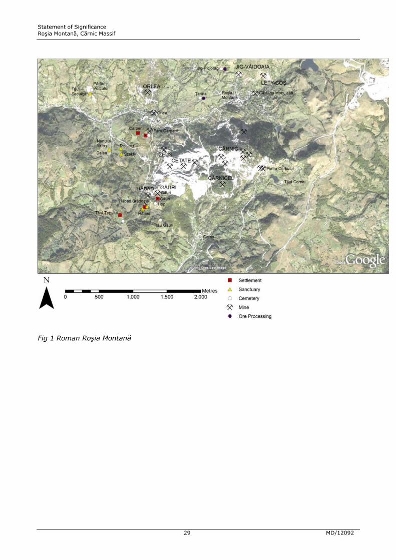
Fig 1 Roman Roúia Montană

Statement of Significance Roúia Montană, Cărnic Massif
30 MD/12092
3.0 THE SIGNIFICANCE OF SPECIFIC ATTRIBUTES
Historic mining landscapes
Roman cultural landscapes: zones of mining activity, and related surface
sites
3.1 The ancient mining zone of Roúia Montană was structured around the exploitation of
four main massifs – Cetate, Cârnic, Jig-Văidoaia, and Orlea, in both opencast and
underground workings, with underground workings also in the areas of Hăbad,
Carpeni, Cârnicel and Coú-Lety. Most of these areas have known associated surface
sites – settlements, ore-processing areas, religious buildings, and cemeteries, and
their existence can be assumed for those that do not. The following description starts
with Cetate and related sites to the West, and then continues around in a roughly
anticlockwise manner, describing the main underground workings and surface
archaeology of the different zones.
Cetate and Hop-Găuri
3.2 The Cetate (‘fortress’) massif is now largely destroyed by communist-era opencast
mining but was formerly one of the two major massifs of the area, along with Cârnic.
Until the commencement of the large opencast mine in the 1970s, the Cetate massif
had four ancient opencast pits (‘curtile Romane’) on the top, and the sides were
riddled with mine galleries of ancient, medieval and Early Modern date. Photographs
taken before the recent mining began show the massif as being similar in shape and
nearly as large as the Cârnic massif. Nearly all of this has been destroyed by the
recent opencast, but ancient workings remain visible in two sectors:
3.3 In the Zeus sector, in the NW of the Cetate massif, Roman opencast and underground
workings are recorded. Gallery G1 was filled in the 2nd century AD; fill continued to
accumulate until the 4th century AD. In the Găuri (‘holes’) area, in the SW part of the
massif, there are ancient fireset workings and ancient and medieval tunnels leading in
from the southern edge of the massif.
Statement of Significance Roúia Montană, Cărnic Massif
31 MD/12092
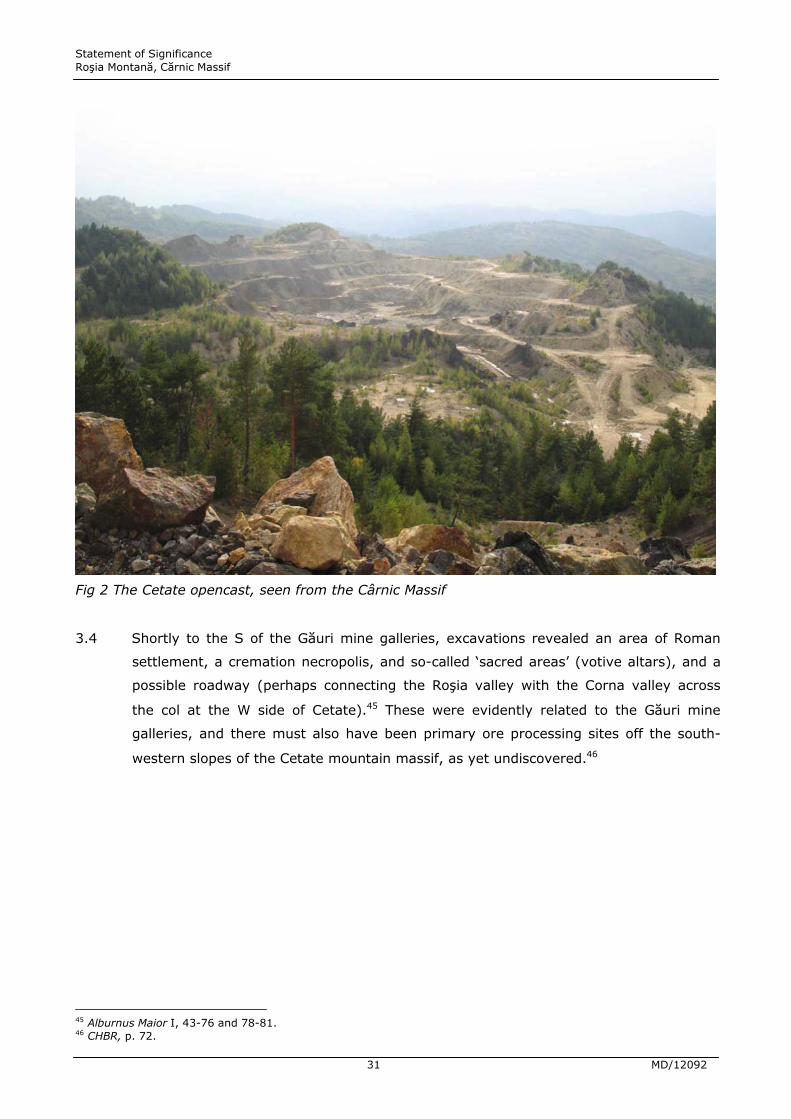
Fig 2 The Cetate opencast, seen from the Cârnic Massif
3.4 Shortly to the S of the Găuri mine galleries, excavations revealed an area of Roman
settlement, a cremation necropolis, and so-called ‘sacred areas’ (votive altars), and a
possible roadway (perhaps connecting the Roúia valley with the Corna valley across
the col at the W side of Cetate).45 These were evidently related to the Găuri mine
galleries, and there must also have been primary ore processing sites off the south-
western slopes of the Cetate mountain massif, as yet undiscovered.46
45 Alburnus Maior I, 43-76 and 78-81. 46 CHBR, p. 72.

Statement of Significance Roúia Montană, Cărnic Massif
32 MD/12092
Fig 3 Entrances to the ancient mine galleries at Găuri
3.5 Significance statement: Significant. The overall cultural value of the Cetate area has
been substantially reduced by the destructive opencast mining. This makes the
remaining galleries and associated archaeological features potentially of high
significance and it should be established that all information of potential value has
been salvaged prior to further destruction.
3.6 In the Hop-Găuri necropolis 250 cremation graves, and five features of uncertain
function (possible burials), were excavated in 2000-2002.47 The grave goods indicate
a date range for this cemetery within the 2nd century AD, in the reigns of Hadrian and
Antoninus Pius. Many of the burials may be of the Mala Kopašnica-Sase (MKS) type,
which would indicate Dardanian colonists, but the published documentation is unclear
on this. The necropolis occupies ground on the top and the very steep sides of a ridge,
suggesting intense local pressure on space.
3.7 Significance statement: Significant. The Hop cemetery has been well excavated, over
an extensive area, though until final publication of the site it is unclear whether

Statement of Significance Roúia Montană, Cărnic Massif
33 MD/12092
significant interpretive questions remain unanswered. As with other cemetery
excavations around Roúia Montană, this will be an important type site for assessing
the prevalence of Dardanian migrants at the mines. This is a significant site.
3.8 About 200 m to the S of the Hop-Găuri cemetery and on a prominent spur on the
opposite side of a minor valley stood a stone circular mausoleum, the Tău Găuri
monument.48 The monument comprised a low circular drum of ashlar quality blocks,
some with mouldings, enclosing what was probably originally a low tumulus over two
phases of primary cremation burials. This now awaits restoration and the construction
of a permanent cover building. Apart from two further cremation graves uncovered
closely adjacent to it, the monument appears to have been an isolated monument.
However, as the immediately surrounding zone was only partially explored, it is
possible, even likely, that more burials existed here and this was part of a second
cemetery zone in the Hop-Găuri area.
Fig 4 The Roman circular mausoleum at Tău Găuri, in its temporary cover building
3.9 Significance statement: Highly significant. The mausoleum is a rare example of a
circular stone mausoleum known from Romania, one possibly similar monument was
47 Alburnus Maior I, 185-242; Alburnus Maior II, pl. 31. 48 Alburnus Maior II.

Statement of Significance Roúia Montană, Cărnic Massif
34 MD/12092
excavated at Ulpia Triana Sarmizegetusa in the 1930s49. On the other hand, the
monument may simply be a larger scale and more grandiose version of a form of
circular burial monument erected over cremation burials that seem typical of
Dardanian migrants in Romania.50 It is certainly worthy of preservation, and further
research in the vicinity might establish more clearly the funerary context and whether
there were additional burials here.
3.10 To the West of Cetate lie a number of localities with surface evidence for ancient sites,
which, together with the presence of artificial waste dumps (of unknown date)
suggests that this area was also worked in the Roman period. These include Hăbad,
Tăul ğapului, and sites in the Nanului valley.
Hăbad
3.11 Parts of a Roman settlement were excavated at Hăbad, revealing buildings with stone
wall footings and two altars. A so-called ‘sacred area’ slightly to the N at at Hăbad
Brădoaia had previously yielded 27 votive inscriptions and some stone wall footings;
but this may have been part of a settlement in which votives were set up.51 The 2001
excavations at Hăbad Brădoaia produced a further five votive altars and two other
epigraphic fragments. Some of the dedications are by the community of the
K(astellum) Ansis, which is probably to be identified as the ancient name for Hăbad.52
There appears to have been a further sacred structure 100 to the W of the Hăbad
plateau on the Vasinca property, where a further five altars have been found. In total
then, the Hăbad area has produced c. 40 inscribed votive altars. The settlement must
have been related to ancient mining galleries, which are known in the area but not
currently visible on the surface. In 1983 the entrance of a gallery was found, and
another gallery, the La Studentu gallery, was investigated between 1999 and 2001;
cut with tools but of a very different cross-section from Roman workings, it is probably
of medieval or Renaissance date, though reworked in the Early Modern period as
evidenced by the installation of wooden shoring and an iron railway.
3.12 Significance statement: Highly Significant. The Hăbad settlement consists of fairly
vestigial buildings, which are worthy of record, but probably do not merit conservation
and presentation. However, the sacred areas of the Hăbad Brădoaia are a different
matter, as the buildings there are associated with inscribed altars, which provide
49 Daicoviciu and Floca 1937. 50 Alburnus Maior II, Plate 46, with legend, illustrates a small and focused concentration of finds of barrow type burials (widely dispersed in Moesia Superior, Moesia Inferior and Thrace to south of the Danube) in the Romanian mining region. 51 Alburnus Maior I, 117-42 (Hăbad) and 143-84 (Hăbad Brădoaia). For altars from the the earlier excavations by Wollmann, see Alburnus Maior I, 148-52, 176-84.

Statement of Significance Roúia Montană, Cărnic Massif
35 MD/12092
important information on the mining community and its religious beliefs, as well as
ancient toponyms and information on collegia (guild) organisations. Comparison with
the Nanului valley sites suggests that further religious structures and altars may exist
in close proximity. It is by no means certain that the excavations carried out at the
Hăbad sites have fully explored them and the connection between sacred areas and
habitations at these sites are still unclear.
Tăul ğapului
3.13 Excavations at Tăul ğapului revealed two stone-walled buildings of a Roman
settlement, with several Roman tumuli nearby.53
3.14 Significance statement: Some significance. Prior to the full publication of what was
excavated here it is difficult to judge the true significance of this site. Nonetheless,
however vestigial the buildings, all the mining settlements of Roman date are likely to
contain important clues as to the cultural affiliations of the different villages around
the main mine workings.
Nanului Valley
3.15 To the West of Cetate, the Nanului Valley feeds into the Roúia valley; excavations here
found a series of ‘sacred areas’ or religious buildings associated with 35 votive altars
inscribed in Latin.54 The three main religious structures, situated on parallel ridges
100-200 m apart from each other, are known after the modern property owners:
Dalea (with at least 13 altars to Fortune, Aesculapius, Mercury, Apollo, Silvanus,
Nymphs, Liber, Terra Mater [Mother Earth], Iuppiter Optimus Maximus [Jupiter Best
and Greatest, abbreviated to IOM]); Drumus (altars to IOM, Terra Mater, the genius
(spirit) of the Sardiates, Janus Geminus, Apollo and reference to a collegium or guild
of the Sardiates); Szekley (altars to Mercury, Apollo, Neptune). The range of deities
attested at these three closely clustered sites is striking and would suggest that this
part of the landscape had unusual religious significance for the mining community.
The identification of four cremation graves suggests an associated funerary zone.
3.16 Significance statement: Highly significant. The religious structures of the Nanului
valley have very high cultural significance, both in a Romanian and a wider European
context. These are fairly extraordinary and unusual Roman ‘temple’ complexes, with a
plethora of gods represented on the numerous altars erected at these locations. In
52 Aburnus Maior I: 151-52 plausibly seeks a link with a Dalmatian civitas Ansium. 53 Aburnus Maior I: 81-91. 54 Alburnus Maior I, 243-368.

Statement of Significance Roúia Montană, Cărnic Massif
36 MD/12092
Roman archaeological terms, the sites are very unusual in character. Full publication
of these sites will be of high interest and there remains the possibility that further
structures and inscriptions remain to be discovered in the area.
Carpeni
3.17 The Carpeni hill lies to the Northwest of Cetate and North of the Nanului Valley,
overlooking the Roúia Valley. Within the hill a network of mining galleries (Păru
Carpeni) has been explored, and two drainage wheel systems were found in 2004.
One included a series of at least four wheel rooms, some with wooden shoring still in
place. Dendrochronology from one of the rooms gives a date of c. AD 155 – this would
be entirely consistent with these galleries being abandoned in the Marcomannic Wars.
3.18 On top of the Carpeni Hill were two structures with hypocaust and tiles with the stamp
of Leg. XIII Gemina (the 13th Legion).55 The hypocaust tiles and flue tiles seem to
have been for heating, rather than identifying these buildings as baths complexes.
They seem to have been prestige buildings within a larger settlement area, and the
tiles with the stamp of the 13th Legion, stationed at Apulum, suggests military
involvement in the construction. As a number of soldiers serving as beneficarii
consularis are known from Roúia Montană, this may well have been their base.
3.19 On the NW part of the Carpeni Hill there was also a funerary zone where 8 cremation
graves have been excavated out of what was presumably a larger area of graves.
3.20 Significance statement: Highly significant. The Carpeni hill has rightly been identified
as of extremely high significance within the overall Roúia Montană complex. The water
wheels are a unique and exceptional discovery, while the buildings with hypocausts on
the top of Carpeni are to date the most prestigious architectural complexes of Roman
date recorded, even if their interpretation is not yet certain. There is a need for further
investigation of the surface and subsurface archaeology.
Cârnic
3.21 ‘The Cârnic massif is one of the two largest mining sectors in Roúia Montană, and the
most important from a patrimonial point of view since the neighbouring massif of
Cetate was significantly impacted by open cast mining.’56 Cârnic is topographically and
geologically the heart of the mining system at all periods; it has the largest and most
55 CHBR, p. 73; Alburnus Maior I, 369-450. 56 CHBR, p. 89.

Statement of Significance Roúia Montană, Cărnic Massif
37 MD/12092
important area of underground mining, both in the extent of its Roman, Early Modern
and recent galleries, and in the deposits of gold exploited in antiquity. There are
4.5 km or more of Roman galleries including at least three types of Roman working
which are unique to this massif. Wax tablets were found in the 19th century in at least
two galleries: several tablets were discovered in 1820 in the ‘St. Ladislau’ Mine, driven
into the massif from the N and 11 tablets in 1850 in the ‘Ohaba – Sf. Simion’ gallery,
driven into the Cârnic massif on the S side, W of the Tăul Cornei. The findspot of
several other tablets found in the Cârnic massif also in 1850 does not seem to have
been closely reported. While the finds of writing tablets all dated before AD 167
suggest that these galleries were abandoned in the Marcomannic Wars and not re-
used, other networks in the heart of the massif have produced some definite evidence
for 3rd-century activity; in the present state of our knowledge the Cârnic massif
contains possibly the only networks with certain 3rd-century AD workings, i.e. re-
occupation/re-working after the presumed abandonment in the Marcomannic Wars. In
several of the networks (1, 2, 3 and 10) Roman working had stopped prematurely
before the ore bodies were exhausted, suggesting that the galleries were abandoned
suddenly for other reasons – presumably, either the Marcomannic invasions or the
Roman withdrawal from Dacia in the AD 270s under Aurelian.
Fig 5 The Cârnic massif seen from Roúia Montană
Statement of Significance Roúia Montană, Cărnic Massif
38 MD/12092
3.22 The following main networks of galleries were recorded by the French/Romanian team
directed by Cauuet between 2000 and 2006:57
• Cârnic 1 network – exploration galleries, with trapezoidal cross-section;
exploitation galleries with superimposed drifts, the upper trapezoidal; a vertical
working chamber whose ceiling is stepped in reverse, and an exploitation chamber
with the roof supported on pillars of undug rock. Small sumps were dug in the floor
of this chamber to collect water and use it for mineral testing of samples from
working faces. In this chamber were found wooden utensils including an ore
shovel, and a scoop for testing the concentration of crushed ore. The creation of
this complex is dated to between AD 106 and the mid Antonine period by
Loeschcke Type X lamps, but one 3rd-century AD radiocarbon date from the
pillared working chamber indicates some later Roman activity.
• Cârnic 2 – later than Cârnic 3, opened after it. Fragments of 2nd-century lamps
were found in the blocking of the entrance, and in the fill at the end of exploration
galleries.
• Cârnic 3 – galleries dated by 2nd-century lamps.
• Cârnic 6 – galleries with wood yielding radiocarbon dates of 2nd/3rd and 3rd/5th
centuries AD suggest that activity here was probably 3rd-century.
• Cârnic 7 – trapezoidal galleries and chambers worked by fire-setting, dated to the
Roman period by 2nd- to 4th-century radiocarbon dates from fire-setting.
• Cârnic 9 lower – dated to the 2nd century AD by Loeschcke X lamps.
• Cârnic 10 upper/intermediate – dated to 2nd century by Loeschcke X lamps.
• Cârnic 13 – underground galleries close to surface and largely choked by muddy
inflows. A roll of litharge (lead oxide derived from the cupellation of silver) was
found here, which had probably been washed in from the surface, confirming
evidence for lead and silver production as well as gold, and suggesting ore-
processing near the gallery entrance.
• Cârnic 14 – opencast and some underground workings.
57 CHBR, pp. 89-92, Alburnus Maior I, 466-71; Cauuet 2008; Cauuet et al. 2009a, 113-84 ; Cauuet el al. 2009 b/c..
Statement of Significance Roúia Montană, Cărnic Massif
39 MD/12092
3.23 Significance statement: Highly significant. This is the most extensive and most
significant Roman underground mining system mapped anywhere in the empire. The
work of the French/Romanian team has been outstanding, and sets a new standard for
underground mining archaeology elsewhere. The subterranean archaeological research
conducted between 2000 and 2006 is presented in the reports as ‘an almost complete
topographical survey of the underground works in this southern area of the massif,
totalling about 16 km of works, 4 km of which are Roman (12 km of modern works
opened by explosives and dating from the 17th to the beginning of the 20th
centuries).’58 These results are certainly impressive, but the northern part of the
massif does not seem to have been subjected to the same intensity of exploration. It
is noticeable that the main cluster of known ancient works which were explored in the
Cârnic massif is concentrated in the centre and the southern part of the massif, with a
surprising absence of ancient remains known in the north. While the ore bodies may
be richer in the central and southern part of the hill, it is surely significant that the
Roman galleries of the ‘St. Ladislau’ Mine, in which several wax tablets were found in
1820, have not been relocated in the recent investigations. Although the recent work
has mapped all the Roman workings which are accessible through the Early Modern
and communist-period galleries, it is very likely that further ancient workings remain
to be found in the northern part of the massif. It is also the case that in the area of
the best preserved Roman galleries, later mine workings have truncated and
obliterated features, necessitating interpolation and interpretation. There is no doubt
that Cauuet and her colleagues have done an excellent job in making sense of the
complex maze of tunnels that result, but it is possible that in the future new
knowledge of Roman and later mining technology might suggest alternative
interpretations and reconstructions of key features. If these uniquely important
features are destroyed, such revisiting of interpretation will be impossible. Although
no new writing tablets have been found in the recent work, past discoveries in the
Cârnic massif mean that there must be a presumption that such material still exists in
parts of the ancient galleries – perhaps particularly in areas that are not currently
accessible from later galleries.
Cârnicel
3.24 Cârnicel is a small hill on the SW of the main Cârnic massif. Early Modern and recent
workings were partly explored in 2000, but parts of the network remained inaccessible
because of collapse and flooding. No Roman or medieval workings were found in this
exploration, but an access to two small galleries with a characteristically Roman
58 CHBR, p. 89.

Statement of Significance Roúia Montană, Cărnic Massif
40 MD/12092
trapezoidal cross-section was uncovered by chance through bulldozing. These short
workings ended in mining faces.59
3.25 Significance statement: Significant. It is important that further efforts are made to
record the Roman workings there.
Corna area
3.26 No settlements or ore-processing areas are yet known which might be related to the
underground workings on Cârnic (South side) and Cârnicel, but the necropolis at Tăul
Cornei was probably related to such settlement and processing sites, which are to be
sought in the vicinity and along the southern slopes of the Cârnic and Cârnicel
massifs.
Fig 6 The modern village of Corna and, in the background from left to right, waste from the
Cetate opencast; Cârnicel; and the Cârnic massif. The proposed mining project would raze
much of the Cârnic massif to about the level of the top of the Cetate waste spills, and bury the
site of Corna village under the tailings facility to the level of the bottom of the spire of the
church on the left, and the base of the church on the right.
59 CHBR, p. 88.

Statement of Significance Roúia Montană, Cărnic Massif
41 MD/12092
3.27 Significance statement: Highly significant. There must be a major missing settlement
site to the south of the Cârnic massif (the equivalent of Early Modern Corna). This is a
major lacuna in the archaeological record, as is the evidence of Roman and Early
Modern ore processing in the Corna valley. The trial trenching carried out in the Corna
valley was on too small a scale to have adequately explored the archaeological
potential.
Fig 7 Tăul Cornei, an early modern header pond for ore-crushing machinery, seen from Piatra
Corbului. The Roman necropolis lay just beyond the pond.
Tăul Cornei
3.28 Tăul Cornei is an artificial header pond that drove stamp mills in the Corna valley in
the late medieval and Early Modern period (water-powered stamp mills are attested in
the Corna Valley as early as AD 157960). Adjacent to it on the S side is a Roman
necropolis, c. 95% of which has been excavated, yielded 324 cremation burials of the
2nd century AD.61 Again, these are a mixture of cremation in situ and the reburial of
remains cremated outside the grave (ad ustrinam). This necropolis must surely have
60 CHBR, p. 16. 61 Alburnus Maior I, 32; Alburnus Maior III.

Statement of Significance Roúia Montană, Cărnic Massif
42 MD/12092
been related to an undiscovered settlement connected with the exploitation of the
southern side of the Cârnic massif.
3.29 Significance statement: Significant. The Tăul Cornei cemetery has been well
excavated, over an extensive area and is now partially published, though interpretive
issues remain unclear. As with other cemetery excavations around Roúia Montană, this
will be an important type site for assessing the prevalence of Dardanian migrants at
the mines.
Coú-Lety
3.30 Between the Cârnic and Jig-Văidoaia hills lies the Coú-Lety area, underneath the NE
part of the historical zone of Roúia Montană village. Several finds of writing tablets
were made in different galleries of the Lety massif in the late 18th century: one tablet
in a lateral gallery of the St Joseph mine in 1788; a further two tablets in a mine
gallery in 1789, and six tablets and a human skeleton in 1791. This zone is also the
location of the 19th-century Cătălina Monuleúti gallery which gave access to ancient
workings in which 10 wax tablets were found in 1855, with lamps, pottery, mining
tools, and shoring as well as at least one, and possibly two, drainage wheel
installations. A Roman drainage wheel installation has recently been discovered in the
Cătălina Monuleúti gallery by the French team; this may or may not be a rediscovery
of the 1855 find.
3.31 Significance statement: Highly significant. Since Roman wax tablets are known from
the Coú-Lety area, it is important that further efforts are made to record the Roman
workings there. Again, the cultural significance of a potential source of written
documents of Roman date cannot be over-emphasised. While it is important that this
area is included in the protected zone of the proposed mine development, many
questions remain about the archaeological development of this area. No ancient
settlement has yet been found associated with these galleries, but the settlement for
the workings in Cos-Lety, Jig-Văidoaia and N side of the Cârnic massif would most
likely have been located underneath the historic centre of Roúia Montană and/or
perhaps extending down the valley towards ğarina, and it is here that the major
settlement of the region (probably the one called Alburnus Maior) is to be expected.
Jig-Văidoaia
3.32 This massif lies on the North side of the valley, overlooking the NW part of Roúia
Montană village. The known underground workings here, visible in the rock face, were
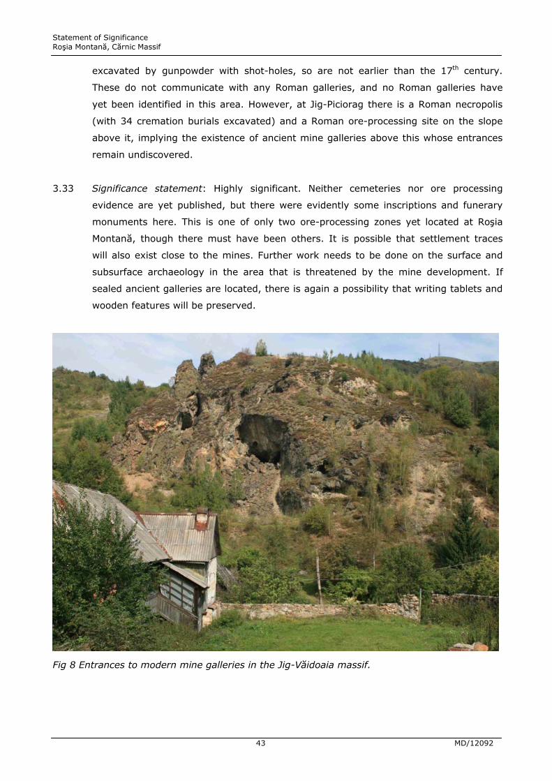
Statement of Significance Roúia Montană, Cărnic Massif
43 MD/12092
excavated by gunpowder with shot-holes, so are not earlier than the 17th century.
These do not communicate with any Roman galleries, and no Roman galleries have
yet been identified in this area. However, at Jig-Piciorag there is a Roman necropolis
(with 34 cremation burials excavated) and a Roman ore-processing site on the slope
above it, implying the existence of ancient mine galleries above this whose entrances
remain undiscovered.
3.33 Significance statement: Highly significant. Neither cemeteries nor ore processing
evidence are yet published, but there were evidently some inscriptions and funerary
monuments here. This is one of only two ore-processing zones yet located at Roúia
Montană, though there must have been others. It is possible that settlement traces
will also exist close to the mines. Further work needs to be done on the surface and
subsurface archaeology in the area that is threatened by the mine development. If
sealed ancient galleries are located, there is again a possibility that writing tablets and
wooden features will be preserved.
Fig 8 Entrances to modern mine galleries in the Jig-Văidoaia massif.

Statement of Significance Roúia Montană, Cărnic Massif
44 MD/12092
Orlea-ğarina
3.34 The Orlea and ğarina hills lie on the N side of the Roúia valley, and contain a dense
network of mineral veins. Much of the hillside is covered with ancient waste dumps,
and there are areas of old opencast workings and collapsed mineshafts, pits and
ditches,62 presumably the water-channels for driving Early Modern stamp mills.
Although the whole area has not yet been systematically explored, 1.5 km of Roman
galleries and 5 km of Early Modern galleries are known so far.63 The French mining
archaeologists consider that up to twice this amount may exist, the openings of
ancient works buried under more recent mining waste.64 In the ğarina area, a sloping
gallery descending presumably from the surface was discovered, with elements of
timber shoring still in place, radiocarbon dating of which indicated an early Roman
date (up to AD 126).65
3.35 At ğarina, a necropolis with 495 burials was excavated, a mixture of cremation in situ
and cremation in which the body has been burned outside the grave and the cremated
remains placed in the grave. The latter form is more dominant in this cemetery. Some
inscribed tombstones and elaborate monuments are known from the cemetery.66 To
the South and East of the necropolis excavation uncovered a possible primary gold
ore-processing area, with stone grinding mortars, grinding tables, and a canal system
– it is unclear whether the latter was for driving Roman stamp mills, or for the
hydraulic sorting of crushed ore.
3.36 Significance statement: High significance. The ğarina area overall appears very
significant archaeologically, though so far most attention has focused on the cemetery
area. More attention needs to be directed to locating the associated settlement and
investigating the ore processing areas of Roman and later date.
3.37 In the Orlea sector a stretch of Roman gallery was made visitable in the 1970s and
incorporated in the first mining museum of 1981; it runs for 45 m with a trapezoidal
cross-section, 1.8 m high and 1.4 m wide at the top, 1.8 m at the base; it then turns
N for some 60 m, with more variable cross-sections. Slightly higher is a small Roman
62 CHBR, p. 93. 63 Of an estimated 10 km of old workings, 6.5 km have been surveyed, CHBR, p. 94. 64 CHBR, pp. 94-95: ‘As the modern workings which allow access did not cover the entire area, it is possible that there may be twice as many ancient workings under this slope, particularly in the surface layer, and that an extensive clearance of the surface could reveal many entrances to operations or explorations … it seems possible that some sloping galleries could be reopened and excavated from the surface. It is also likely that workshops for handling the ore were installed on the surface, next to these access points.’. 65 1965 +- 40 BP; calibrated using OxCal and the 2009 atmospheric curve = 46 BC to AD 126 at 95.4% probability. The date range given in CHBR, p. 94 uses an old and less correct calibration curve. 66 Alburnus Maior I, 38-39.
Statement of Significance Roúia Montană, Cărnic Massif
45 MD/12092
working, intersected by a modern gallery at the Racoúi level. In the Roman galleries
discovered here a wooden notched ladder was found, and radiocarbon dated to the
2nd century AD.67
3.38 Significance statement: Highly significant. The underground evidence at Orlea is very
significant and the preservation of wooden elements illustrates the potential for the
future discovery of writing tablets, hydraulic features and so on. On the surface, no
Roman settlement or ore processing area has yet been discovered in the Orlea sector,
but can be presumed to have existed, given the density of ancient mining there, and
further work is needed to identify them.68 The Early Modern activity here may well
also be very significant, but does not appear to have been researched in any detail.
3.39 To the West of Orlea lies a Roman necropolis at Pârâul Porcului-Tăul Secuilor; with
287 cremation graves identified, of which 277 have been excavated, a mixture of
cremation in situ and ad ustrinam (on a pyre outside the grave); over half were
covered by a mound of earth ringed at the base with a single row of stones. Grave
goods date the cemetery to the 2nd century AD.69
3.40 Significance statement: Significant. Inscriptions and fragments of elaborate funerary
monuments have come from this cemetery and although extensively excavated, there
may well be further material built into modern walls and boundaries. The nature of
associated buildings (settlement or religious structures) remains unclear and might be
clarified by further excavation. The identification of the settlement to which the
cemetery related is a priority for further research.
The Medieval and Renaissance mining landscape
Balmoúeúti - Gura Minei
3.41 A substantial settlement delineated by ditch and bank has been located high on the
northern slopes of the Roúia valley near Balmoúeúti and Gura Roúiei at a location
known as Islaz. Few details are yet published and the Cultural Heritage Baseline
Report suggests the site was of Roman date, though we were informed during our
field visit that it is now thought to be a fortified medieval settlement.70
67 CHBR, p. 94. 68 CHBR, p. 94-5. 69 Alburnus Maior I, 34-36. 70 The site is ‘located at about 3 km of Gura Roúiei and at 4 km of the PiaĠă site, at the end of the St. Cross site (level +714). The area is located N of the main road connecting the two locations. In the peak area of the northern slope of the Roúia Valley, between the Balmoúeúti hamlet and the Vârtop village, in the site called Islaz. On this occasion a fortress with ditch and vallum was identified and dated to (on the basis of the discovered archaeological inventory) the Roman period.’ CHBR, p. 257 ; cf. also Alburnus Maior I, 36-38.

Statement of Significance Roúia Montană, Cărnic Massif
46 MD/12092
3.42 Significance statement: Significant. Given the absence of other medieval settlement in
the Roúia Montană area, this is of considerable local importance for our understanding
of activity in the region in the post-Roman period and prior to the re-colonisation of
the valley by large-scale mining operations in the Early Modern period.
Mine workings
3.43 The evidence for medieval mining galleries is at present rather slight – as for example
at the La Studentu gallery in the Hăbad area. The diagnostic criteria for identifying
these galleries are that they are less regularly cut than the Roman galleries using
hand tools. It seems likely that a fuller inventory of all the underground mine works in
the various massifs would identify further examples.
3.44 Significance statement: Significant. The rarity of medieval traces in the Roúia Montană
area gives any evidence of mining from this period a high national importance, but it
is unlikely that the mine works of this period will have European-wide significance. On
present evidence, it appears that exploitation was on a much reduced scale in the
medieval era. Nonetheless, this is still an element in the story of Roúia Montană and
should not be neglected.
The Early Modern mining landscape71
3.45 The Early Modern mining landscape is in part well known from historical and
topographical researches, notably the survey of Pošepny.72 Individual building surveys
have recently been carried out of some of the main historic properties in Roúia
Montană and nearby villages.73 In is interesting that the CHBR makes a distinction
between the recording of the ‘architecture’ of these structures and ‘archaeological
investigations’. The result is that we have a very incomplete picture of the Early
Modern mining landscape, despite the fact that a considerable quantity of data has
been recorded on individual buildings spread across the landscape. This is a classic
example of the phenomenon observed at the start of this report that cultural heritage
value is sometimes applied to sites/buildings, rather than to landscapes or
communities, with much of the bigger picture being lost.
3.46 The modern toponym of Roúia Montană applies to an extended area of nucleated
settlement in the Roúia valley on the N side of the Cetate and Cârnic massifs. It is
71 The Early Modern Period-late 17th to 19th century 72 Pošepny 1868a/b. 73 CHBR, pp. 56-69; Popoiu 2010, 16-37, 82-114, 137-47..

Statement of Significance Roúia Montană, Cărnic Massif
47 MD/12092
known that contemporary Roúia Montană has assimilated a number of smaller
hamlets, which were formerly separate settlements running down the Roúia valley
towards Abrud. The CHBR survey distinguishes two settlement areas within Roúia
Montană: a nucleated core around the main square at the E end of the valley and a
ribbon-like settlement running down the line of the stream towards the W and
encompassing ğarina, Orlea, Susaúi and Gura Minei, etc.74 Corna village also appears
to be the product of a series of three initially separate hamlets on the S side of the
Cârnic massif: Corna Centru, Tăul Cornei and Bunta.75 What is currently lacking in the
documentation is a clear sense of how and when the assimilation of a series of
separate mining settlements was achieved. There appear to have been significant
differences between the two settlement areas on either side of the Cârnic massif:
Roúia Montană was multi-ethnic and incorporated many different groups of people,
while Romanians were more predominant at Corna.76 There are 10 religious buildings,
relating to seven denominations, and 12 cemeteries relating to these communities.
Again, it would be interesting to explore the historical contingency of this observation
– is this a recent development, or does it reflect profound differences in the mining
community throughout the Early Modern and modern periods? There is currently too
little chronological precision in the accounts of this period. With the available map
sources (especially Pošepny) and documentary records, it ought to be possible to
target archaeological investigations equivalent to those conducted on Roman period
sites and that could illuminate further the developmental sequence of the surface
archaeology of the 17th-early 20th centuries.
3.47 Significance statement: Highly significant. Roúia Montană and its landscape can
illustrate in great detail the Early Modern mining heritage of Romania. This is not
achieved by present overviews and the data gathered. Until more detailed work is
carried out, it is difficult to ascribe precise significance to many of the component
sites, but it is clear that Roúia Montană, Corna and the other main hamlets assimilated
into the two main centres all are highly significant. So too are the cemetery areas,
where inscriptions should be systematically recorded and monument types recorded to
trace chronological phasing and community composition. A third area that is under-
explored concerns the ore processing features – specifically the artificial ponds (tăul)
and canals that were constructed to provide the water to drive the stamping mills. At
the peak of production, there were hundreds of individual stamping mills in the Roúia
Montană landscape and a good sample of these sites should be excavated, in order to
record more fully the characteristic features of these water powered crushers and the
associated features relating to further grinding, beneficiation, washing and melting of
74 CHBR, pp. 57. 75 CHBR, p. 58. 76 CHBR, pp. 58 and 63-64.

Statement of Significance Roúia Montană, Cărnic Massif
48 MD/12092
the gold ore. The extraction and processing of other minerals from the ores, notably
silver, also needs to be investigated archaeologically to improve knowledge and
understanding of the technologies involved.
3.48 The underground evidence relating to this period is clearly abundant and is discussed
more fully below (see mining technology section). A crucial aspect of the period was
the use of explosives in opening galleries, allowing a deeper and more extensive
penetration of the massifs than ever before.
3.49 Significance statement: Highly significant. This aspect merits much more detailed
investigation than hitherto accorded it.
The 20th-century mining landscape
3.50 Much the same comments already made of the Early Modern period apply equally to
20th-century mining landscape, with the added point that the rejection of the
communist regime since 1989 has opened the way for the landscape features of this
period to be obliterated without record.77 In 100 years’ time, what are the questions
we shall want to ask about the communist period mining works at Roúia Montană? And
will the evidence to answer them still exist in documentary archives and in the
archaeological record? Industrial archaeology in other parts of the world recognises
the significance of the recent past, when mechanisation and new technologies
transformed the nature and scale of exploitation. While the CHBR seems to envisage
the most recent phases of mining as marking an end of the cultural landscape of the
region, it has surely been simply the most recent phase of successive phases of
exploitation, each of which erases some part of the past culture, but also puts in place
new elements of significance.78
3.51 Significance statement: Highly significant, if socio-politically underappreciated in
Romania at present. A more ambitious programme of collecting data on and the
mining paraphernalia of the modern period should be embarked on, drawing on the
experience of, for instance, the Bochum mining museum in Germany – which accords
equal significance in its displays to every period of activity. The evidence of
underground workings is dealt with in the next section below.
77 It is noteworthy that the CHBR, p. 18 accords very little attention to the Communist period and emphasises ‘reprisals and torture’ carried out by the state against former private mine owners suspected of hiding caches of gold ore. There is no overall assessment of the potential heritage significance of the features of modern underground and opencast workings, or the architectural heritage of the 20th-century mining administration complexes, stockyards, machinery and plant. 78 CHBR, p. 19: ‘The disappearance of the traditional mining industry during the 1950’s and the extinction of private property in the gold-mining industry, compounded by surface exploitation in the 1970’s, also significantly impacted the cultural landscape.’

Statement of Significance Roúia Montană, Cărnic Massif
49 MD/12092
3.52 Despite the extensive survey, the trial pitting and the full-scale excavation of selected
areas of key sites, there remain many features of the overall mining landscape that
are not adequately recorded or understood. While a good sample of the most visible
archaeology has been recorded, one can question whether this is enough to justify, in
such an exceptional heritage landscape, the archaeological discharge of large blocks of
the terrain. Given the highly significant status accorded to the complex overall, at the
very least it would be reasonable to require a higher level of completeness to allow
preservation by record rather than preservation in situ.
a) c)
b)
d)
Fig 9 Ore-crushing technology – the stamp mills of Rosia Montana and their predecessors: a) Traditional stamp mill at the old Minvest mining museum of Rosia Montana; b) Woodcut showing a stamp mill, from Georgius Agricola’s De Re Metallica, 1556; c) Roman anvil stone from a stamp mill (Villamonta de la Valduerna, Spain); d) Anvil stone from a traditional stamp mill, Rosia Montana.

Statement of Significance Roúia Montană, Cărnic Massif
50 MD/12092
4.0 THE SIGNIFICANCE OF HISTORIC PROCESSES
Mining technology
4.1 Roúia Montană provides an exceptional illustration of different mining techniques used
throughout the ages, some of which are unique examples for their period. The overall
rating for mining technology is: highly significant.
Roman
4.2 The Roman workings include opencast workings, 7km of underground workings with
many galleries dug using picks or hammer and chisel, with a characteristic trapezoidal
cross-section, and others dug using fire-setting techniques. The tool-dug galleries
include stepped descending galleries, and, uniquely. a spiral staircase descent,
working chambers with the roof supported on pillars of undug rock, and vertical
exploitation chambers. Several installations for water-lifting wheels have been found
in the Păru Carpeni and Cătălina Monuleúti areas.

Statement of Significance Roúia Montană, Cărnic Massif
51 MD/12092
Fig 10 Găuri – opencast working with a deep cut where a vein has been followed from the
surface.
Opencast workings
4.3 Although most of the Roman opencast workings on Cetate have been destroyed by the
modern opencast pit begun in the 1970s, some remains survive that show Roman
opencast techniques not commonly documented elsewhere. In the Zeus sector on the
NW side of Cetate, narrow open cuts, over 6.5 m deep, show where Roman miners
have followed ore veins down from the surface. The walls of these cuts have sockets
for bracing timbers to prevent collapse. These narrower workings would formerly have
connected with the much wider opencast pits – the four curtile Romane that existed
Statement of Significance Roúia Montană, Cărnic Massif
52 MD/12092
on Cetate prior to the 1970s. In the Găuri sector (on the SW side of Cetate),
firesetting techniques have been used to break up the very hard Dacite rock here,
working down from the surface on three superimposed levels 14 m long, 1.30 m wide,
and 18.4 m deep.
4.4 Significance statement: Significant. Would be highly significant if more of the Cetate
works survived intact.
Underground workings
4.5 The Roúia Montană mining zone preserves an extraordinarily rich set of evidence for
Roman subterranean mining, with a wide variety of techniques and types of working
that reveal important evidence about miners’ strategies of exploration and
exploitation, and how these are adapted to local conditions within a particular massif
or ore body.
4.6 Galleries: Horizontal and sloping galleries include: adits, essentially entrance
passageways driven in from the outside of the hill; drifts, where a vein is followed
along its length; exploration galleries; and communications galleries between different
parts of an underground network. Most of the Roman galleries at Roúia Montană are
dug with a characteristic trapezoidal cross section, so that the gallery widens from 1-
1.4 m at the ceiling to 1.8-2.5 m at the floor, with a height usually between 1.5 and 2
m. This shape is optimised for safety, as the sloping walls provide some lateral
discharge of vertical thrust from above, and the dimensions are designed for ease of
movement, allowing miners circulating in the galleries or transporting ore to walk
upright. This is a contrast with prehistoric or medieval mining works, which tend to be
lower and narrower, minimising the amount of rock to be excavated but making
movement through the mine more difficult. The Romans had evidently realised that it
was worth making the galleries bigger in order to facilitate the removal of waste rock
and ore from the working face to the surface.
4.7 Trapezoidal galleries as found at Roúia Montană are characteristic of other Roman
mines in Romania, but are not well known outside Romania. Recent research suggests
that they probably exist in Roman mines in Serbia, which may be the region of origin
of this technique; if so, the trapezoidal shape of the galleries at Roúia Montană would
be a further reflection of the settlement of Dardanian miners there. As there is no firm
evidence for pre-Roman underground gold mining in Romania (the Dacian gold seems
to have derived from alluvial deposits), the trapezoidal galleries can hardly be a
Dacian technique, and their sudden appearance at Roman-period mines in Romania is

Statement of Significance Roúia Montană, Cărnic Massif
53 MD/12092
best explained by the import of the technique by the mine administration and/or its
workforce from elsewhere.
Fig 11 Roman mine gallery with trapezoidal cross-section in the Cârnic massif.
4.8 Although the trapezoidal gallery cross-section is paralleled at other Roman mines in
Romania, the galleries at Roúia Montană are particularly well worked and preserved,
enabling deductions to be made about working techniques. Examination of the side
walls and ceilings of some galleries shows that they were worked by advancing across
the whole cross-section of the gallery a few centimetres at a time79, either with a pick
or more usually with hammer and chisel. Galleries that have been abandoned before
being finished also suggest that the working face was left relatively neat; this clean
method of working would have aided the miners in distinguishing whether the ore
veins continued in the direction they were working, or not.
4.9 In sloping exploration and communication galleries, steps were cut in the floor to
make movement along the gallery easier. Most stepped galleries are found in the
Cârnic massif, although one is known from Păru Carpeni; stepped galleries are again a
characteristically Roman feature not found in prehistoric or medieval mining. The long

Statement of Significance Roúia Montană, Cărnic Massif
54 MD/12092
curving stepped gallery Cârnic 2 - G32 in the Cârnic massif, 70 m long, with 125 steps
descending 30 m, is an especially fine example; this ends suddenly in a blank wall and
must still have been in the course of being dug when the mining works here were
abandoned, probably in either AD 167 or 271. In areas of very hard rock, fire-setting
was used to break up the rock and make it easier to work. This involved lighting fires
against the walls and roof of a chamber, causing the rock to fracture with a
characteristically rounded gallery or chamber profile. Particularly good exampes of
working chambers in which this technique was used survive in the Piatra Corbului part
of the Cârnic massif.
Fig 12 Roman trapezoidal gallery in Păru Carpeni, with working marks on the walls and roof
showing how the gallery was advanced a few centimetres at a time.
4.10 Niches for oil lamps to illuminate the galleries, and perhaps particularly the working
face, are found in the walls of the galleries. As with other Roman mines, many of
these have an uneven base in which it would be impossible to stand a lamp – but the
exceptional preservation at Roúia Montană has provided the answer to the mystery of
how they functioned. In the Cârnic massif the Franco-Romanian mining archaeology
79 Cauuet 2009b Cârnic 13, Fig 800.

Statement of Significance Roúia Montană, Cărnic Massif
55 MD/12092
team found lumps of clay pressed onto the base of some lamp niches, and one of
these bore the imprint of the base a Roman lamp; clay was thus used to keep the
lamps in place.
Fig 13 Roman stepped descending gallery in the Cârnic massif.
4.11 Exploitation workings: Where miners encountered veins of ore underground, these
might be worked in one of several ways. The simplest, in the case of a vein of limited
height and width, would be to follow it with the gallery, as a drift. But if a vein running
horizontally extended vertically (or nearly so) above or below normal gallery height, it
was worked as a series of superimposed drifts, the upper with a trapezoidal cross-
section, and the lower ones laterally offset from it, following the slanting of the vein.

Statement of Significance Roúia Montană, Cărnic Massif
56 MD/12092
In some cases three or even four superimposed galleries can be traced (e.g. Cârnic 1,
G2).
Fig 14 Superimposed Roman galleries in the Orlea massif. (The bracing timbers are modern.)
4.12 Where a vein dipped more sharply the exploitation chamber would need to descend
rapidly. Vertical exploitation chambers with ceilings that look like steps in reverse (ɋe.g.
Cârnic 3, G50) show that the Roman miners dug these chambers as a series of short
horizontal working levels of a more or less standard height, stopping each level when
the vein ran out and deepening the floor to create a new level as far as the vein
extended horizontally again. Such vertical working chambers with a ceiling of reversed
stairs are unique to the Cârnic massif.

Statement of Significance Roúia Montană, Cărnic Massif
57 MD/12092
4.13 The exploitation of wide veins, crossing veins or complicated brecciated structures
demanded expanding and widening the working chamber, in some cases (again,
unique to Cârnic) creating veritable halls with the roof supported on pillars of undug
rock (e.g. Cârnic 1, Ch. 1). Geological analysis of the mineral content of the ore in
such pillars reveals the extent to which the Roman miners were concerned about the
safety and stability of their underground workings; even where the rock has an
extremely high metal content, of e.g. 27.4 g/tonne of gold, 21 g/tonne silver, pillars of
rock were left undug to support the roof (Cârnic 1, Ch. 5).80
4.14 Geological research has identified several cases (e.g. the vertical working chamber
Cârnic 1 – D10; the ascending drift Cârnic 2 – G71; Cârnic 3 – D9 and G53; Cârnic 10
– D2) where ancient exploitation of heavily mineralised structures with high gold and
silver content has stopped prematurely, and this cannot be attributed to the difficulties
of underground working in these locations, but must instead be a result of external
circumstances.81 Based on indications from the wooden writing tablets and the
historical context, the obvious inference is that these external circumstances were
either the Marcomannic invasions of AD 167 or the Roman withdrawal c. AD 271. If
this is so, these areas should provide a snapshot of Roman mining exploitation areas
in mid-operation (much as an unfinished sculpture reveals the working methods of the
sculptor). Given the other 2nd-century finds in these galleries of the Cârnic network,
the Marcomannic wars might be the preferred context for such an abandonment.
4.15 This unique snapshot of work in progress has enabled observations and deductions
about Roman mining practices that are wholly new and unparalleled from other mining
sites. It shows, for example, that the large working chambers were developed by
driving radiating galleries off them in a star-shape and then knocking through the
walls of the galleries, leaving some pillars of rock to support the roof. In the working
faces of some drifts slots have been cut in the rock, apparently to take samples of the
ore to test whether it was worth continuing further. This hypothesis is strengthened by
the discovery of basins cut in the floor of some of the working chambers, and the find
of a wooden panning scoop; it seems that samples of ore were being crushed, panned
and concentrated in the basins as a constant check on the mineral content of the
gallery faces that were being worked.
80 DFS 2009, 70. 81 DFS 2009: 74, 76-77, 82-4, 99, 105.
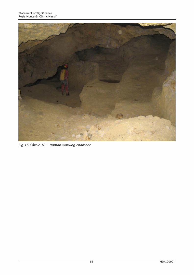
Statement of Significance Roúia Montană, Cărnic Massif
58 MD/12092
Fig 15 Cârnic 10 – Roman working chamber

Statement of Significance Roúia Montană, Cărnic Massif
59 MD/12092
Fig 16 Cârnic – Roman exploitation chamber with basins (now flooded) cut in the floor.
4.16 The underground conditions of preservation have allowed the discovery of wooden
mining tools and equipment, including a mineral shovel, a scoop for testing the
concentration of crushed ore, and several ladders made out of a single tree trunk with
notches cut for the steps. Together, all these finds constitute a remarkably detailed
picture of working practices and techniques in Roman underground mining.
4.17 Mine drainage: Dealing with underground water is one of the major problems in
mining engineering, and the state of preservation of some of the evidence from Roúia
Montană provides unparalleled opportunities to study the Roman technology for
tackling these problems. Where galleries within a massif were above the ground
surface surrounding the hill, they could in principle be drained to the outside of the hill
by means of a drainage gallery. For deeper mining below the water table, water-lifting
devices (drainage wheels or Archimedes screws) were required.
4.18 Two areas of the Roman mines at Roúia Montană have produced evidence for water-
lifting wheels – the Păru Carpeni network and the Cătălina Monuleúti mine. This is of
considerable importance because, although water-lifting wheels and wheel-chambers

Statement of Significance Roúia Montană, Cărnic Massif
60 MD/12092
are known from other Roman mines, this is the first time that they have been
discovered under controlled excavation conditions, allowing for the recovery of much
more information than in the past. Indeed, many previous discoveries were made, and
subsequently destroyed, in modern opencast operations at mines elsewhere, and so
the wheel chambers can no longer be examined even if elements of the wheels survive
in museums. The wheels, driven by men treading the outside of the rim, had hollow
wooden compartments on the rim, which picked up water at the bottom of the cycle
and discharged it into a wooden channel in the upper gallery at the top. In Păru
Carpeni four, and perhaps five, water-lifting wheel chambers were discovered in
series, each lifting water up to a gallery from which another wheel lifted it to the next.
One wheel is reported to have been discovered in 1855 in the Cătălina Monuleúti
mine; a wheel installation has more recently been discovered there which may be the
same one, or a second one.

Statement of Significance Roúia Montană, Cărnic Massif
61 MD/12092
Fig 17 Păru Carpeni – chamber for a wooden drainage wheel in the Roman mine network. The
wooden bearing block for the wheel axle is visible towards the top of the picture, and Roman
wooden shoring towards the bottom.
4.19 Water-wheels have not to date been discovered in the Cârnic massif, suggesting that
the mine workings there were served by one or more drainage galleries draining water
out to the surface at the side of the hill, which are yet to be found. In Cârnic 1 - G23 a
drainage channel was cut in the floor of the gallery, originally covered over with wood
so that it would not impede movement along the gallery.
4.20 Significance statement: Highly significant. The Roman galleries, exploitation chambers
and drainage works are all of exceptional international interest and importance.

Statement of Significance Roúia Montană, Cărnic Massif
62 MD/12092
Ore processing
4.21 Once the ore was extracted from the mine, it had to be pounded, crushed and milled
to enable sorting by hydraulic concentration. The high-grade material was then
smelted to release the metal. Very little is known in detail about how these processes
operated at Roúia Montană in the Roman period, Only two ore-processing zones have
yet been discovered, at Jig-Văidoaia and ğarina, with evidence of hand-mills for
grinding crushed ore, and of metal-working. There is great potential to learn more,
particularly about the crushing and smelting of the ore
4.22 Significance statement: Highly significant. This aspect of the Roúia Montană mining
landscape appears to be much understudied at present, but is of high international
importance and is highly vulnerable to destruction in the current development
programme. Given the scale of Roman activity around Roúia Montană, there is
considerable potential for the processing technologies adopted to have been
technologically advanced. One possibility is that the ore-processing areas could
produce evidence for Roman-era water-powered stamping mills (such as seem to have
been identified at some of the major Spanish mining districts82).
Medieval and Renaissance workings
4.23 As already noted, underground galleries dated to the medieval and Renaissance
periods are surprisingly few, indicating a sharp contrast between the scale of Roman
and medieval mining at Roúia Montană. The medieval and Renaissance workings are
identified on the basis that they were dug with tools rather than explosives (whose
use in mining starts in the 17th century) but have a different profile from the Roman
galleries, which they sometimes intersect. An example of such medieval or
Renaissance workings is the La Studentu gallery in the Hăbad sector.
4.24 Significance statement: Significant. The rare evidence of medieval exploitation is
important for that very reason. The technologies employed and scale of workings need
to be studied as part of the diachronic story of mine history at Roúia Montană. The
medieval exploitation at Roúia Montană will clearly not be of European significance, in
that more significant mines of that period are known elsewhere.
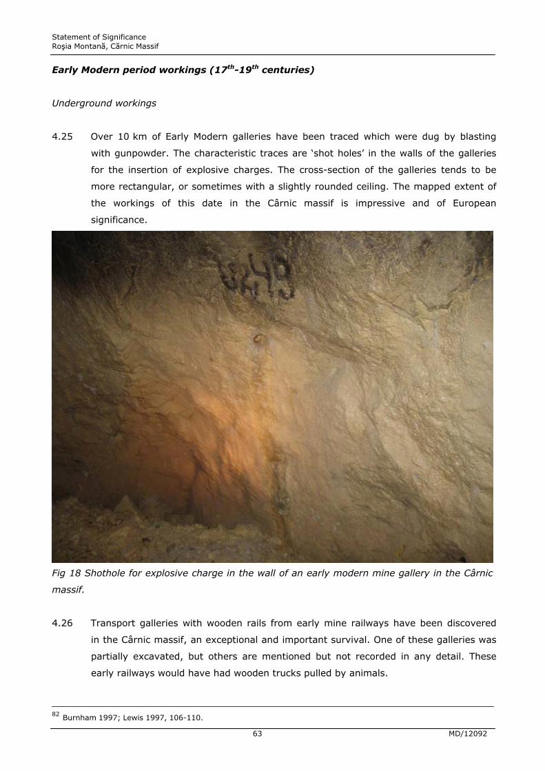
Statement of Significance Roúia Montană, Cărnic Massif
63 MD/12092
Early Modern period workings (17th-19th centuries)
Underground workings
4.25 Over 10 km of Early Modern galleries have been traced which were dug by blasting
with gunpowder. The characteristic traces are ‘shot holes’ in the walls of the galleries
for the insertion of explosive charges. The cross-section of the galleries tends to be
more rectangular, or sometimes with a slightly rounded ceiling. The mapped extent of
the workings of this date in the Cârnic massif is impressive and of European
significance.
Fig 18 Shothole for explosive charge in the wall of an early modern mine gallery in the Cârnic
massif.
4.26 Transport galleries with wooden rails from early mine railways have been discovered
in the Cârnic massif, an exceptional and important survival. One of these galleries was
partially excavated, but others are mentioned but not recorded in any detail. These
early railways would have had wooden trucks pulled by animals.
82 Burnham 1997; Lewis 1997, 106-110.

Statement of Significance Roúia Montană, Cărnic Massif
64 MD/12092
4.27 The Early Modern workings include some vast working chambers (‘corandas’) of
extraordinary size. To date, however, the 10 km of galleries and exploitation
chambers have not been dated more closely than within the broad bracket of 17th-19th
centuries AD. Indeed, relatively little archaeological recording has been done of the
Early Modern galleries and works.83
4.28 Significance statement: Highly significant. This is one of the largest mining complexes
of the Austro-Hungarian empire and evidently retains many unusual technological
features (such as the wooden trackways) that illustrate the mining techniques of the
time. Detailed recording of the mining features of this period could illuminate the
organisation and sequence of development of the Austro-Hungarian imperial mining
enterprise.
Ore-processing
4.29 The beneficiation and ore-processing activities required by the boom in mining under
the Austrian empire generated a characteristic early industrial landscape of ‘tauls’ or
header ponds for the water to drive stamp mills for crushing the ore. There is
documentary archive evidence for a large number of stamp mills in different valleys
already in the 17th century (in the Corna Valley alone there were 77 in 1676; 119 in
1757; and 226 in 1772).84
4.30 These stamp mills, in which a water-driven wheel turned an axle with cams that raised
and then dropped heavy stamps operating within a vertical framework, were used
until the mines were nationalised under the communists in 1948. The technology is
identical to stamp mills illustrated in Georgius Agricola’s 1538 publication on mining,
De Re Metallica, and is thought to be of Roman origin. Roman anvil stones with wear
marks similar to those on surviving Early Modern anvil stones from Roúia Montană are
known from Roman mining sites in Spain, Portugal and Wales.85
4.31 Two of these stamp mills survive, relocated to the open-air Minvest mining museum.
For the rest, what remains is the landscape of header ponds and channels feeding off
them: Tăul Cornei, Tăul Brazi, Tăul Siccata, Tău Găuri, Tăul ğapului, Tăul Secuilior,
etc. Of these the most clearly visible and understandable in terms of its function is
Tăul Cornei, scheduled to disappear under a waste dump if the mining project
proceeds.
83 Compare the single summary paragraph accorded these workings in the CHBR, p. 99, with the much longer account of Roman workings. 84 CHBR, p. 16; Popoiu 2010, 18, 150 (fig.). 85 E.g. Três Minas (Portugal), Dolaucothi (Wales) (Burnham 1997; Lewis 1997).

Statement of Significance Roúia Montană, Cărnic Massif
65 MD/12092
4.32 Significance statement: Highly significant. The industrial archaeology of the stamping
sites is of considerable interest, but at present not recorded in detail in the Roúia
Montană area.
Fig 19 Communist-era transport gallery in the Cârnic massif.
20th-century workings
4.33 The extensive network of 20th-century galleries was dug by blasting and used a
narrow gauge iron railway for the transport of ore. In the communist period after the
nationalisation of the mines in 1948, the underground workings were extended to
connect all the main working areas underground, with a grid system of exploration
galleries criss-crossing the Cetate, Cârnic and Orlea massifs in particular, and large
transport galleries linking these areas. These were wide galleries reinforced with
concrete blocks, and equipped with iron railways, in some cases with tracks in both
directions.

Statement of Significance Roúia Montană, Cărnic Massif
66 MD/12092
Fig 20 Abandoned extraction machine in the Cetate opencast.
4.34 In the 1970s, a large opencast pit was developed by Minvest on Cetate, worked by a
series of concentric stepped benches. The base of the opencast now lies at 890 m,
whereas formerly the summit of the hill was at 1003 m, meaning that up to 113 m of
the hill has been quarried away. One extraction machine abandoned in the opencast
may still be seen in place.
4.35 Significance statement: Highly significant. The industrial archaeology of the
communist era mines has not been undertaken on any scale, and the component parts
are disappearing fast as buildings fall into disrepair, machinery is broken up and the
mine workings are under threat of obliteration in the new proposed mining
development. However, this period was also part of Romania’s mining history and the
Communist era represents a third significant phase of large-scale exploitation of ore
bodies at Roúia Montană whose techniques are worthy of detailed study. In the future,
historical interest will focus on this period and it is important that documentary
sources are supported by archaeological record.
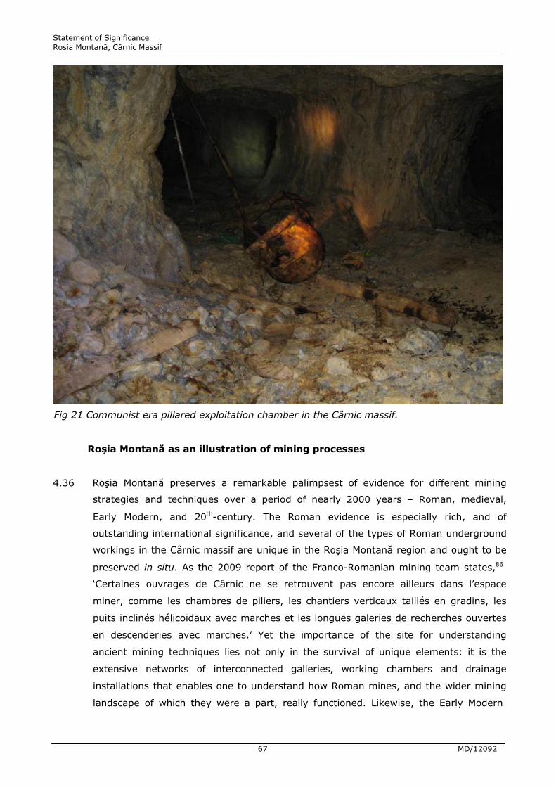
Statement of Significance Roúia Montană, Cărnic Massif
67 MD/12092
Fig 21 Communist era pillared exploitation chamber in the Cârnic massif.
Roúia Montană as an illustration of mining processes
4.36 Roúia Montană preserves a remarkable palimpsest of evidence for different mining
strategies and techniques over a period of nearly 2000 years – Roman, medieval,
Early Modern, and 20th-century. The Roman evidence is especially rich, and of
outstanding international significance, and several of the types of Roman underground
workings in the Cârnic massif are unique in the Roúia Montană region and ought to be
preserved in situ. As the 2009 report of the Franco-Romanian mining team states,86
‘Certaines ouvrages de Cârnic ne se retrouvent pas encore ailleurs dans l’espace
miner, comme les chambres de piliers, les chantiers verticaux taillés en gradins, les
puits inclinés hélicoïdaux avec marches et les longues galeries de recherches ouvertes
en descenderies avec marches.’ Yet the importance of the site for understanding
ancient mining techniques lies not only in the survival of unique elements: it is the
extensive networks of interconnected galleries, working chambers and drainage
installations that enables one to understand how Roman mines, and the wider mining
landscape of which they were a part, really functioned. Likewise, the Early Modern

Statement of Significance Roúia Montană, Cărnic Massif
68 MD/12092
landscape was structured in large part around the ‘tauls’ and the water-powered
stamp mills along the channels that flowed from them, with the two main settlements
of Roúia Montană and Corna related to the main valleys in which the stamps operated.
This wider overview of ancient mining is not something that can be adequately
preserved by salvaging merely a sample – either of underground galleries or of tăul
ponds – and sacrificing the rest.
Organisation of mine workings
Roman
4.37 The epigraphic evidence from the Roúia Montană area can be combined with data from
other Roman imperial mining areas to construct a picture of how Roman mining
activity was organised. The general picture is of varying degrees of State control,
attested by the involvement of the army – the mining control fort and administrative
centre at Ampelum – and the presence at Roúia Montană of some soldiers seconded as
beneficiarii consularis etc. The tile stamps of the 13th Legion also indicate an active
official presence. However, it is characteristic of Roman state control that this did not
necessarily equate with direct military supervision of the extraction and processing
work. It seems that the Roman state encouraged or mandated colonisation of the area
by skilled miners from neighbouring provinces, particularly Dardanians and Dalmatians
(see next section). The Roman state often used mixed forms of exploitation, involving
both forced labour and free waged labour (the latter illustrated by the labour contract
writing tablets). Miners and mine contractors often belonged to consortia (societas)
and professional associations (collegia), such as burial clubs. All these are attested at
Roúia Montană: the writing tablets include labour contracts for waged labour;87 but
they also name slaves and record the purchase of slaves (including children) – in one
case at the settlement around the legionary fortress of Apulum/Alba Iulia. One tablet
records the setting up of a partnership or consortium, the societas danistariae,
specifying the amount of capital that each partner contributes at the outset (IDR 1,
44). Collegia are attested both in votive inscriptions and in one of the writing tablets,
in which a burial club or collegium is wound up in February AD 167 because too few of
its members remain.88
4.38 The professionalism of miners is evidenced by the technological discussion above and
the scale of the underground workings gives insights into the organisation. It is
possible that the mining district was not administered as a uniform block, but that
86 Cauuet et al. 2009a, 211. 87 TabCerD X, XI and XII. 88 TabCerD I (28 March 167).

Statement of Significance Roúia Montană, Cărnic Massif
69 MD/12092
different areas of the massifs were actually exploited in different ways – some perhaps
under direct state supervision, others leased to contractors, etc.89 The size of some of
the networks, which must each have been a single concession operated by an
individual or a societas, indicates considerable capital and may allow some estimates
of the size of workforces in particular mining concessions.
4.39 The archaeological evidence for the distribution of settlement indicates that the mining
community was split into a number of villages, each with its own cemetery and
probably ore-processing facilities, and associated with a set of mine workings in a
particular massif. Some of the sites discovered are probably to be equated with
various toponyms attested in the writing tablets – Immenosum Maius, Deusara,
Kartum, and the Vicus Pirustarum, although we cannot yet propose exact matches and
it is possible that one or more of these might lie outside the region. The votive altars
allow the identification of a further site, Kastellum Ansis, as Hăbad. The main
settlement of the region, to judge by the frequency with which it occurs in the writing
tablets, was the still unidentified main centre of Alburnus Maior, the location where
nine of the documents were drawn up and witnessed.90
4.40 We gain an impression of underground workings operated largely by entrepreneurs or
companies employing a mixture of free and servile labour. We do not know whether
the military were involved in ore-processing, but the military administrators at the
very least must have ensured that the state received its share of the gold and silver
from the mines and supervised the transport of ore down the Roúia and Arieú valleys
to Ampelum/Zlatna and then to Apulum/Alba Iulia, This is where further epigraphic
finds and potentially tablets could help elucidate additional details of the mining
administration. We do not yet know the full story, but there is huge potential to come
closer to this at Roúia Montană than at other known Roman mining sites.
4.41 Significance statement: Highly significant. Roúia Montană is the only Roman mining
district where free waged labour is directly attested, and the degree of detail provided
on the workings of a societas and a collegium is exceptional. The value of the written
evidence is enhanced by being able to propose matches with some of the
archaeologically attested features; the building with the hypocaust features and
stamps of the 13th Legion is well placed to control the route out of the mining zone
down the Roúia valley. As with the Early Modern period, there is a great opportunity to
89 As Hirt 2010, 232-35 suggests. 90 The documents signed and witnessed at Alburnus Maior are: TabCerD I, II, IV, V, IX, X, XIII, XVIII and XXII. The theory that the toponym Alburnus Maior mentioned in the writing tablets may refer not to a specific site, but rather to a wider mining region, such as the ‘Golden Quadrilateral’ has a long history, summarised by Russu 1975, p. 186. This is, however, impossible: in Roman administrative and legal practice, the location where a documents is drawn up and witnessed is always a specific place (town or village) rather than a district or region.
Statement of Significance Roúia Montană, Cărnic Massif
70 MD/12092
bring together historical sources and surface evidence for the organisation of mining
and processing activity here.
Medieval mine organisation
4.42 At present little is known of the medieval mining organisation, beyond the fact that
there were German miners in the region under the authority of Hungarian kings by the
13th century. By the 14th century, gold mines were evidently owned by local patricians,
but it is unclear what this translated to on the ground. Cetate appears to have been a
focal point of mining activity.91
4.43 Significance statement: Significant. Certainly merits further work to combine
archaeological and historical sources.
Early Modern mine organisation
4.44 Although there are signs that mining activity was reviving in the late medieval period,
the major resurgence was due to another imperial intervention. From 1688-1848
Transylvania was under the control of the Hapsburg empire, having been liberated
from Ottoman control. This was a period of significant redevelopment of the Roúia
Montană mining district, with various measures taken to stimulate migration of labour,
the opening of new mines and the increase in processing capacity.92 It is interesting
that the Hapsburg control of Transylvania in part echoes Roman administrative
arrangements, with the Austro-Hungarian fortress at Alba Iulia replicating the Roman
legionary fortress of Apulum at the same location just outside the mountain range to
the SE of Roúia Montană. The administration of mining districts is not always a smooth
process of contracts signed and ore exported. Mining communities can be volatile,
especially if pressed by imperial regimes. The available source material for the Austro-
Hungarian period is a potentially rich resource for building a detailed picture of the
normal operation of the mining administration and what could go wrong (and how this
might be reflected in the archaeological record):
4.45 ‘As early as 1781-1782, the people of Roúia Montană lodged a complaint against
compulsory labour hours with the authorities (Wollmann et al., 1982). In the uprising
that followed, led by Horea, Cloúca and Criúan, people from villages of the Arieú Valley
91 CHBR, p. 15-16; Popoiu 2010, 16-17. 92 CHBR, p. 16-17, Popoiu 2010, 17-19; Pošepny 1868a; Sântimbreanu and Wollmann 1974; and Wollmann 1998 are the key scholarly works, along with Sântimbreanu 1989.

Statement of Significance Roúia Montană, Cărnic Massif
71 MD/12092
burned the Hungarians’ houses, the Catholic Church and a few mine entries; however,
the imperial authorities suppressed the uprising.’93
4.46 There is considerable potential to build on the historical and map-based studies
achieved to date, with enhanced assessment of the industrial archaeology left behind
by the Hapsburg mine organisation.
4.47 Significance statement: Highly significant. As for the Roman period, there is a great
opportunity to bring together historical sources and surface evidence for the
organisation of mining and processing activity here.
20th –century mine organisation
4.48 The early 20th century saw much private mining exploitation ‘based on associations of
individuals and small share companies. Concessionary companies mined the deeper
deposits and individuals the shallower ones, often on steeper slopes.’94 All this
changed in 1948, with the nationalisation of the mines under Communist control and
private exploitation being forbidden. The memories of the communist period are still
fresh and, for some of the mining community, bitter. Yet this was also a period of
large-scale exploitation, achieved with a large infrastructure of facilities and workings.
The record of these years should be retained for future generations to study; it is
interesting to note that very little detail of this phase is included in the Cultural
Heritage Baseline Report.
4.49 Statement of significance: Significant. The Communist regime dominated Romanian
history and society for 40 years and its effects are still felt today. While there is an
understandable inclination to reject the events and realities of these years, it will be
important to future generations to understand them. The profound impact that the
Communist administration of mining activity had on many families in Roúia Montană
(both good and bad) needs to be recorded in detail for posterity. The centres of
mining administration are historic monuments too and before allowing these to be lost
to neglect or active demolition, decisions should be taken as objectively as possible
about what of this recent phase of mining history can and should be conserved.
93 CHBR, p. 17. 94 CHBR, p. 17.

Statement of Significance Roúia Montană, Cărnic Massif
72 MD/12092
Mining communities
Roman
4.50 Archaeological and epigraphic evidence from Roúia Montană and other Roman mining
sites in Dacia indicates that a sizeable population group active in the Roman mining
operations in Dacia were migrants of Dalmatian and Dardanian origin, attested
principally by Dardanian and Dalmatian names on inscriptions, dedications to the Dea
Dardanica (‘Dardanian goddess’), and the MKS burial type characteristic of the areas
where these settlers came from.95 The settlement of these people in Dacia would have
been ordered (perhaps through forced resettlement) or encouraged by the Roman
state in order to exploit the mines, using personnel skilled in mining in their region of
origin. This picture is richly illustrated at Roúia Montană by several strands of
evidence: a writing tablet of AD 159 mentions the Vicus Pirustarum or ‘village of the
Pirustae’, a Dalmatian people;96 names on funerary stelae and votive altars include
some characteristic Illyrian names (Bato, Beucus, Dasius, Verzo, etc.); and finally, the
distinctive trapezoidal cross-section of Roman mines in Dacia, so characteristic of the
Roman workings at Roúia Montană, seems also to be paralleled at some Roman mines
in Serbia (e.g. Kosmaj), and the provinces of Dalmatia and Upper Moesia may be the
origin of this technique.97
4.51 But Dardanian and Dalmatian settlers were by no means the only people at Roúia
Montană: inscriptions from the site also indicate the presence of others: Greeks,
Roman citizens, and military personnel, principally beneficarii consularis, who were
soldiers of the 13th legion seconded to Roúia Montană with administrative duties
concerned with mining administration.98
4.52 The religious dedications at the various settlements and sacred areas in the mining
zone give further insights into the nature of the communities there. The votive altars
are dedicated to much the same array of deities as found in other Balkan mining sites,
and many are of course particularly appropriate to mining communities: Terra Mater
(Mother Earth); Sol (associated with gold); Diana (with silver); Mercury (trade and
commerce); Silvanus (a woodland deity, perhaps of particular relevance to loggers
and carpenters involved in providing the timber shoring for mine galleries).
Interestingly, the beneficarii consularis dedicated mainly to Jupiter Optimus Maximus
95 Daicoviciu 1961; Mrozek 1968; Noeske 1977; Russo 1984; Tudor and Vladescu 1972. 96 TabCerD 9., 6th May AD 159. 97 See Dušaniü 1977 for a summary of the Roman mining evidence in the Dalmatian and Dardanian areas. 98 Hirt 2010, 232-35; Noeske 1977.

Statement of Significance Roúia Montană, Cărnic Massif
73 MD/12092
(Jupiter Best and Greatest), a deity strongly identified with the welfare of the Roman
state.
4.53 The distribution of inscriptions and of more elaborate Roman funerary monuments (for
instance those ornamented with sculptures of lions, pine cones, etc.) is of interest in
that it may hint at social differentiation among the mining communities. Final
conclusions cannot be drawn until all the new inscriptions and sculptural elements are
published, but the initial impression is that there is more of this material in the Roúia
valley than in the Corna valley. The main ritual and religious centres seem to have
been to the W of the Cetate massif (in the Nanului valley and Hăbad area), while the
cemeteries with the largest numbers and more elaborate tombstones were Pârâul
Porcului, ğarina and Jig, with the cemeteries on the fringes of the Corna valley at Tăul
Cornei and Hop yielding such items only rarely (the mausoleum at Tău Găuri is
exceptional in every sense). This may hint at some social differentiation between the
settlements and people on the North side of Cetate and Cârnic and those on the South
of these massifs.
4.54 Full publication of all the cemetery excavations may reveal further patterning in burial
monuments, rituals and grave inclusions that hint at social or ethnic divisions within
and between different funerary sites. It may also give pointers to the presence or not
of actual Dacians among the mining community. Isotopic analysis of teeth from the
cremated remains could look at aspects of diet among the mining community and
could help distinguish between people who lived all their lives in the area of Roúia
Montană and those who migrated to the mining district after childhood.
4.55 Significance statement: Highly significant. The combination of a rich epigraphic record,
extensive cemetery excavations and potential for scientific analysis affords an
unprecedented level of detail on the make-up of a Roman mining community in
comparison with evidence known from other mining sites in the Roman empire..
Medieval
4.56 At present there is ‘no flesh on the bones’ of the bare historical narrative. Archaeology
needs to be employed more actively to locate and document the evidence of the
mining community in this period.
4.57 Significance statement: Significant. The contrast between the Roman, Medieval and
Early Modern phases of mining can only be fully appreciated if all are researched on an
equal basis.

Statement of Significance Roúia Montană, Cărnic Massif
74 MD/12092
Early Modern
4.58 In many periods of mining activity, the essential story of mining communities involves
the integration of migrant groups with established populations. The Austro-Hungarian
exploitation of Roúia Montană was accomplished in part though the in-migration of
mining experts and experienced labour from Germany, Hungary and Austria, bringing
with them new material culture, building styles and adding to the mix of religious
affiliation in the valley.99 The archaeological correlates of this mixed community could
be further explored.100
4.59 Significance statement: Highly significant. The story of the Early Modern community
extends beyond a few historic houses in Roúia Montană.
20th century
4.60 There has been an attempt in recent years to record the oral memories of members of
the modern mining community. This is a tremendously important initiative and one
that evokes the long continuity of mining communities in the Roúia Montană area,
sometimes prospering, sometimes struggling under the weight of State control. It
creates a link between the modern population and a landscape biography of
successive phases of mining activity.
4.61 Significance statement: Highly significant. The starting point with successful
conservation measures to preserve aspects of the mining landscapes and the past
mining heritage of Roúia Montană is to engage the residual mining communities with
the past. The construction of a landscape biography that links the present community
with a long history of mining community is a key desideratum of successful Cultural
Resource Management of the area’s heritage.
Potential to yield future information
4.62 Despite the richness of the evidence surviving at Roúia Montană for the scale,
technology and organisation of mining, and for the life of the mining communities,
over nearly 2000 years, the site still holds enormous potential to yield more
99 CHBR, p. 17, ‘They changed the ethnic composition and aspect of the place by bringing in elements of Western culture, such as Central-European homes, elements of baroque decorative art, German clothing, furniture ironware, chinaware, and Vienna glassware.’ 100 CHBR, p.56-71 provides a list of buildings of the Early Modern period, but without conveying a sense of how these functioned as parts of a complex and diverse living community.
Statement of Significance Roúia Montană, Cărnic Massif
75 MD/12092
information, much of which will be lost of the archaeological remains are not
preserved in situ.
4.63 A number of gaps in the archaeological record suggest areas where much more is to
be learned:
Settlement
4.64 A pattern of distributed nucleated settlement in the Roman period, with small villages
dotted around the various hillsides where mining operations were going on, is implied
by the distribution of necropoleis around massifs with underground workings.
However, many more necropoleis than settlements have been recognised. One or
more major settlements associated with mine workings in the southern part of Cârnic
and at Cârnicel are to be expected in the vicinity of the necropolis at Tăul Cornei.
Likewise, there are necropoleis and ore-processing area at Jig-Văidoaia, and also at
ğarina, which must be linked with the mine workings in these areas, but no settlement
is yet known that can be associated with them. Likewise no settlement is known that
would go with the mine workings in the Orlea massif and the necropolis at Pârâul
Porcului-Tăul Secuilor. Medieval and Early Modern settlement (in the latter case
beyond the identified historic buildings of the historic core of Roúia Montană itself) are
still poorly explored.
Ore-processing
4.65 Ore-processing sites are known only at Jig-Văidoaia and ğarina, and even there they
are poorly understood. Were water-powered ore-crushing machines being used, as in
other Roman mines in Spain, Portugal and Wales, and indeed as at Roúia Montană
itself some 1500 years later? What smelting technologies were used?
Underground mining galleries and networks
4.66 At Jig-Văidoaia the presence of ancient mines is implied by ore-processing areas high
up the hillside; surely the miners were not carrying ore up the hill to process it, and
even though no Roman mine galleries are known here they are to be expected, their
entrances covered by later mining waste.

Statement of Significance Roúia Montană, Cărnic Massif
76 MD/12092
4.67 A similar point may be made for the Orlea and ğarina sectors, where the Cultural
Heritage Baseline Report states:
‘The workings investigated in this sector were relatively evenly distributed, which
reflected among other things, the strong density of the ore bodies. As the modern
workings which allow access did not cover the entire area, it is possible that there may
be twice as many ancient workings under this slope, particularly in the surface layer,
and that an extensive clearance of the surface could reveal many entrances to
operations or explorations. In the light of current information, it seems possible that
some sloping galleries could be reopened and excavated from the surface. It is also
likely that workshops for handling the ore were installed on the surface, next to these
underground access points. Therefore, it seems to be of major importance, in view of
the rarity of remains of ancient handling workshops known currently in the valley, to
plan for extensive surface excavations of both entrances to galleries and spaces
devoted for processing the ore, i.e. for ancient metallurgy.’ 101
4.68 At Cârnic, the same point holds true even more strongly. The map of underground
workings in the Cârnic massif that accompanies the proposal for archaeological
discharge shows a large concentration of Roman galleries in the south-central part of
the massif and around Piatra Corbului, with a small network N of the central part of
the hill. It is evident that the underground survey strategy has necessarily been
conditioned by access through the communist-era network of tunnels within the
interior of the massif, but this is less likely to intercept the Roman workings that
entered the massif from the northern side, since the recent grid of galleries is less
dense here. However, since the Romans seem to have riddled the other main massifs
of the region with tunnels from all accessible sides, it is certain that they worked
Cârnic from the N too. Indeed, a plan of the Cârnic works explored in 2000-2005
strongly suggests this, with a number of short galleries traced on the N side of the
massif; it is unlikely that all Roman mine galleries here have yet been found and more
are to be expected here.
4.69 The same observation can be made for Cârnicel, in this case confirmed by the fact
that the underground survey found no Roman galleries, but some Roman exploration
galleries, whose entrances had been covered with later mining waste, were found by
chance during bulldozing works.
4.70 Indeed, Cârnic is an area where many elements of the picture are still incomplete –
although it was the richest ore body and contains the largest Roman gallery networks,
101 CHBR, pp. 94-95.

Statement of Significance Roúia Montană, Cărnic Massif
77 MD/12092
we are still missing drainage galleries, mine adits and entrances, underground
workings on the N side of the massif, and settlement and ore processing areas on the
S side.
Early Modern workings
4.71 The extensive 17th-/19th-century underground workings are barely recorded,
everywhere, beyond basic topographical planning. They constitute an important
monument of Early Modern industrial archaeology in Romania. In some cases they
include wooden rails from early mine railways, an extremely rare and important
survival. Surprisingly and regrettably, these Early Modern galleries have not been the
subject of much study in the archaeological work to date; indeed, one might say that
they have been almost completely neglected in favour of documenting the ancient
works. No attempt has been made to date them more closely than between the 17th
and 19th centuries, although a study of the placement, frequency and sizes of shot-
holes might identify diagnostic patterns or features that could allow closer dating. As
is clearly stated in the documentation supplied to us:
‘Ces travaux modernes n’ont pas fait l’objet d’investigations particulières, exceptée la
voie de roulage en bois d’une galerie de Piatra Corbului: dans deux secteurs, ils ont été
néanmoins relevés en plan ce qui permet de confronter nos relevés avec les plans
d’archives.’102
4.72 It would seem, therefore, that in the Cârnic massif only one of the Early Modern
galleries has been excavated, and in only two sectors have they been planned ; many
of the Early Modern galleries must remain unplanned, and largely unrecorded. This is
a significant and major omission in the archaeological research programme, and it is
clear that, on these grounds alone, granting the archaeological discharge would be
problematic, as it would involve the destruction of a major piece of industrial
archaeological heritage without proper record, thus bringing into question the
application of the ‘preservation by record’ strategy.103
102 Document Final de Synthèse 2009, p.55 on the underground investigations in the Cârnic massif. 103 Note that ‘modernes’ in this context means 17th-19th centuries, that is works of considerable antiquity.

Statement of Significance Roúia Montană, Cărnic Massif
78 MD/12092
5.0 BIBLIOGRAPHY
Alburnus Maior I = Damian 2010
Alburnus MaiorII = Simion et al. 2004
Alburnus Maior III = Damian et al. 2008
CHBR – Cultural Heritage Baseline = Stantec 2006
DFS = Cauuet 2009a vol 1 or 2 (French edition)
TabCerD = Russu I I 1975
Andreúoiu B, et al 2007 Kombinat. Ruine Industiale Ale Epocii de Aur/Industrial Ruins of the
Golden Era, Bucureúti:Igloo
Barker G, Gilbertson D, Mattingly D, 2007 Archaeology and Desertification: the Wadi Faynan
Landscape Survey, southern Jordan. Oxford: Oxbow.
Bartels C, Küpeer-Eichas C, (eds.) 2008 Cultural Heritage and Landscapes in Europe/
Landschaften: Kulturelles Erbe in Europa (Proceedings of the International Conference,
Bochum, 8-10 June 2007), Bochum (German Mining Museum Bochum).
Bartels C, Ruiz del Árbol M, van Londen H, Orejas A, (eds) 2008 Landmarks. Profiling Europe’s
Landscapes, Bochum (BDM, COST, CSIC).
Burnham B C, 1997 Roman mining at Dolaucothi: the implications of the 1991-3 excavations
near Carreg Pumsaint, Britannia 28: 325-36.
Cauuet B, 2008 Les mines d’or et d’argent romaines de Roúia Montană (nord-ouest Roumanie).
Unpublished paper for ‘Conference sur l’archéologie préventive, Council of Europe,
Paris.
Cauuet B, et al., 2009a Raport de Cercetare Archeologică Preventivă Masivul Cârnic, Roúia
Montană, România Proiectul Minier Roúia Montană Document Final de Sinteză 2009
Volumul 1 Text integral IlustraĠii Explorare IlustraĠii Geologie RMGC/Universitatea
Toulouse Le Mirail.
Cauuet B, et al., 2009b Raport de Cercetare Archeologică Preventivă Masivul Cârnic, Roúia
Montană, România Proiectul Minier Roúia Montană Document Final de Sinteză 2009
Volumul 2 IlustraĠii Arheologie RMGC/Universitatea Toulouse Le Mirail.
Clark K 1998 Conservation Plans A Guide for the Perplexed, Context 58, Edinburgh:IHBC
Clark K 1999, Conservation Plans In Action, EH:London
Clark K 2001, Informed Conservation, EH:London
Clark J, Darlington J, Fairclough G, 2003. Pathways to Europe’s Landscape, Heide.
Council of Europe, 2000 European Landscape Convention. European Treaty Series no. 176.
Council of Europe, Strasbourg.
Daicoviciu C, 1961 ‘Castella’ Dalmatarum in Dacia. Apulum 4, 51-8.
Daicoviciu C, Floca O, 1937 Mausoleul Aureliilor de la Sarmizegetusa, Sargetia 1, 1-23.
Damian P (ed.), 2010 Alburnus Maior I, Cluj-Napoca: Mega 2nd ed.
Statement of Significance Roúia Montană, Cărnic Massif
79 MD/12092
Damian P et al 2008 Necropola Romană de IncineraĠie de la Tăul Corna, Partea I, Alburnus
Maior III, Cluj-Napoca:Mega.
Déjeant-Pons M, 2002 The European Landscape Convention, Florence, in Fairclough and
Rippon 2002, 13-24.
Domergue C, 1990 Les mines de la Péninsule Ibérique dans l'antiquité romaine. Rome.
Domerque C, 2008 Les mines antiques: la production des métaux aux époques grecque et
romaine. Picard, Paris.
Dušaniü S, 1977 Aspects of Roman mining in Noricum, Pannonia, Dalmatia and Moesia
Superior. Aufstieg und Niedergang der römischen Welt 6.1: 52-94.
Fairclough G, Rippon S, 2002 Europe’s Cultural Landscape: archaeologists and the
management of change. EAC Occasional Paper 2, Brussels.
Hauptmann A, 2007 The Archaeometallurgy of Copper. Evidence from Faynan, Jordan. Berlin,
Springer.
Hirt A M, 2010 Imperial Mines and Quarries in the Roman World. Organizational aspects 27 BC
– AD 235, Oxford.
Lewis M J T, 1997 Millstone and hammer: the origins of water power. Hull , University of Hull.
Mattingly D J, 2005 Cultural landscapes in Europe: projects and networks, in Ruiz del Árbol
and Orejas 2005, 61-67.
Maxfield V A, Peacock D P S, 2001a The Roman Imperial Quarries. Survey and Excavation at
Mons Porphyrites. Volume 1: topography and quarries. London.
Maxfield V A, Peacock D P S, 2001b Survey and Excavation at Mons Claudianus 1987-1993.
Volume 1I: Excavations Part 1. Cairo.
Moore H, 2007 Summary of the Cultural Heritage Management Plans Included in the Report on
the Environmental Impact Assessment for the Roúia Montană Project, Giffords/RMGC.
Mrozek S, 1968 Aspects sociaux et administratifs des mines d’or en Dacie. Apulum 7/1, 307-
26.
Noeske H-C, 1977 Studien zur Verwaltung und Bevölkerung der dakischen Goldbergwerke in
römischer Zeit. Bonner Jahrbücher Band 177: 271-416.
Oltean I, 2007 Dacia. Landscape, Colonisation, Romanisation. London.
Orejas A, 2001 Atlas Historique des Zones Minieres D’Europe. 500BC-500AD. OPOEC,
Luxembourg. Vol. I.
Orejas A, 2003 Atlas Historique des Zones Minieres D’Europe. 500BC-500AD. OPOEC,
Luxembourg. Vol. II.
Orejas A, Mattingly D, Clavel-Lévêque M, (eds) 2009 From Present to Past through Landscape.
CSIC:Madrid.
Parker Pearson M, Pollard J, Thomas J and Welham K. 2010. Newhenge. British Archaeology
Jan/Feb 2010: 14-21.
Peacock D P S, Maxfield V, 1997 Survey and Excavation at Mons Claudianus 1987-1993. I.
Topography and Quarries, Cairo:IFAO.

Statement of Significance Roúia Montană, Cărnic Massif
80 MD/12092
Peacock D P S, Maxfield V, 2007 The Roman Imperial Quarries. Survey and Excavation at Mons
Porphyrites 1994-1998. Volume 2. The excavations. London:Egypt Exploration Society.
Popoiu P, 2010 Roúia Montană Studiu Etnologic - Roúia Montană Ethnological Study, EdiĠia II-
a, Cluj Napoca: Editura Mega.
Pošepny F, 1868a Die montangeologische Aufnahme des Verespataker Goldergbaugebietes im
Komitat Alsófehá und ein Manuskript.
Pošepny F, 1868b Geologisch-montanistische Karte des Goldbergbaureviers Abrudbanya-
Verespatak.
RiúcuĠa C, 2007 Exploatarea Roúia Montană InvestiĠii economice úi realităĠi social-culturale
(1919-1948) - Roúia Montană Mine Economic Investments and Social Cultural realities
(1919-1948) Alba Iulia:Anthropos-Alburnus Maior.
Roúia Montană Project, 2006a 4 Potential Impacts (Including Transboundary) on the
Environmental Components and Related Mitigation Measures. 4.8 Social and Economical
Environment, 4.9 Cultural and Ethnical Conditions, Cultural Heritage, EIA Study Report
Vol 14, S C Roúia Montană Gold Corporation
Roúia Montană Project, 2006b Plan M – Cultural Heritage Management Plan Part II Mangement
for the Historical Monuments and Protected Zones from Roúia Montană Area, Part III
Cultural Heritage Management Plan, Management Plans Vol 33, S C Roúia Montană Gold
Corporation
Ruiz del Árbol M, Orejas A, (eds 2006. Landscapes as Cultural Heritage in the European
Research. CSIC, Madrid.
Russu I I, 1975 InscriĠile Daciei Romane Vol I Introducere Istorică si Epigraphică Diplomele
Militare & TabliĠele Cerate, Bucureúti:Academiei Republicii Socialiste.
Russu I I, 1984 InscriĠile Daciei Romane Vol III, Bucureúti:Academiei Republicii Socialiste.
Sánchez-Palencia F J, (ed) 2000 Las Médulas (León). Un paisaje cultural en la Asturia
Augustaza, León.
Sánchez-Palencia F J, Fernández-Posse M D, Fernández Manzano J, Orejas A, 1996. La zona
arqueológica de Las Médulas, León. Guiá arqueológica. León.
Sánchez-Palencia F J, Orejas A, Ruiz del Árbol M, 2008a The Roman Gold Mines of
Northwestern Hispania: Miners and peasants, in Ch. Bartels and Küpeer-Eichas, C.
(eds.) Cultural Heritage and Landscapes in Europe/ Landschaften: Kulturelles Erbe in
Europa (Proceedings of the International Conference, Bochum, 8-10 June 2007),
Bochum (German Mining Museum Bochum): 427-452.
Sánchez-Palencia F-J, Orejas A, Ruiz del Árbol M, Sastre I, 2008b ‘Las Médulas (León, Spain).
A rural and mining landscape’ in Bartels C, Ruiz del Árbol M, van Londen H, Orejas A,
(eds.), Landmarks. Profiling Europe’s Landscapes, Bochum (BDM, COST, CSIC): 113-
124.
Sântimbreau A, 1989 Muzeul mineritului din Roúia Montană, Bucuereúti.

Statement of Significance Roúia Montană, Cărnic Massif
81 MD/12092
Sântimbreau A and Wollmann V, 1974 Aspecte tehnice ale exploatării aurului în perioda
romană la Alburnus Maior (Roúia Montană), Apulum 12, 240-77.
Simion M, Apostol V, Vleja D, 2004 Monumental funerar circular – The Circular Funeral
Monument, Alburnus Maior II, Bucharest: Muzeul NaĠional de Istoire a Romăniei.
National History .
Simion M, 2006 Mining Districts in Roman Period in Romania. Assessment of Published
Sources in Romania, in Stantec Consulting 2006: 130-42.
Smith L-J 2004 Archaeological Theory and the Politics of Cultural Heritage, London: Routledge
Stantec Consulting, 2006 Cultural Heritage Baseline Report, Stantec Consulting/S C Roúia
Monană Gold Corporation SA.
Tudor D, and Vladescu C, (1972). Dardanii la Romula-Malva. Apulum 10: 183-90.
Wollman V, 1996 Mineratul metalifer, extragerea sari si carierele de piatra in Dacia Romana -
Der erzbergbau, die salzgewinnung und die steinbruche im romischen Dakien, BMN XIII
Cluj.

Statement of Significance Roúia Montană, Cărnic Massif
82 MD/12092
APPENDIX 1

Statement of Significance Roúia Montană, Cărnic Massif
83 MD/12092
Appendix 1: Itinerary of visit of UK experts
Fig 22 Itinerary of visit of UK experts

Statement of Significance Roúia Montană, Cărnic Massif
84 MD/12092
Site Visit and Inspection: Roúia Montană
Wednesday 8th September 2010
Arrival at Cluj Napoca and travel to hotel near Roúia Montană via Alba Iulia.
Thursday 9th September 2010
9 am arrival at Roúia Montană.
Introduction to mining areas RMGC and Health and Safety Issues.
Presentation of documents by RMGC.
Visit to Arul Apusenilor exhibition on Roman and later mining activity.
Site Visits:
am – Surface sites. Tăul Tapului, Hăbad, Hăbad Brădoaia, Hop, Tău Găuri, Hop-Găuri (cemetery and settlement area), Găuri mineworkings, Nanului Valley, Păru Carpeni settlement & Carpeni hypocausted building, Cărnic Massif view across Cetate, Piatra Corbului, Corna Valley panorama.
pm – Underground sites. Cătălina Monuleúti mine gallery, Păru Carpeni to ğarina and Orlea galleries & old mining museum (lapidary display and mining machinery).
Friday 10th September 2010
Review
Site Visits:
am – Underground. Cărnic galleries (including Piatra Corbului) (Cărnic 1, 13, 6, 2, 3) and (Cărnic 9, 10).
pm – Abrud and Corna Valley, Corna, Tăul Corna, views of Roúia Poieni copper mine and Roúia Montană Valley, Cetate rim and opencast, NW side of Cărnic.
Saturday 11th September 2010
am – Presentation by RMGC.
Site Visits (all surface)
am – Review of workshop where 3D model of mine gallery was being produced, Jig- Vădoaiai, Jig-Piciorag, ğarina, Orlea, Pârâul Porcului & Tăul Secuilor, panorama towards Zeus area of Cetate, Communist era main mine entrance and stockyard West of Orlea.
pm – departure for Cluj Napoca.
Sunday 12 September 2010
Return to UK.

Statement of Significance Roúia Montană, Cărnic Massif
85 MD/12092
APPENDIX 2

Statement of Significance Roúia Montană, Cărnic Massif
86 MD/12092
Appendix 2: Roúia Montană and Other Roman Gold Mines
The table below is adapted from material published in the Cultural Heritage Baseline Report.104
In that study a number of conclusions are drawn that seem to diminish the significance of what has been found at Roúia Montană and there is an implication that future research at some of the other known gold mining sites in Romania or elsewhere in the Roman empire will more than off-set the destruction of the mining landscape at Roúia Montană.
‘[T]he Roman gold-mining locations listed … demonstrate that Roúia Montană cannot have been unique in terms of its Roman mining history. Furthermore, the evidence to date strongly hints at the presence of at least 47 Roman gold-mining centres and related developments in Transylvania and Banat, of which at least 14 have already produced evidence of major Roman gold-mining operations with associated settlements and related infrastructure. Whilst it is clear that some have disappeared under more recent developments over the last 200 years, others seem to shine brightly as beacons encouraging future archaeological activity and research. … the sum of archaeological research to date gives “a deformed image of Alburnus Maior.” It is important that this point is stressed. The leads and hints elsewhere strongly imply that future archaeological research elsewhere in Romania will change current impressions of Roúia Montană. The place and the programme of archaeological investigations from 2000- 2006 are apparently of unparalleled importance now; however, it appears that they may well not always be.’105
‘This summary assessment confirms that there is now known to have been extensive gold mining in several provinces of the Roman Empire. … Many of these sites can merely be identified as places in which international scholarship has concluded that there was gold- mining activity. On the other hand, a significant number of others can be shown to have been major centres with associated infrastructure and technical development, which closely parallel those at Roúia Montană. Some of these, indeed, also include well-preserved remains. Despite its undoubted archaeological and historical significance, the conclusion must be that Roúia Montană is one of a number of gold-mining centres at least of comparable importance throughout the Roman Empire. Research into Roman gold mining and gold mines continues and develops apace, and there can be no doubt that many more sites await discovery and archaeological elucidation.’106
These comments can be challenged. While there is no doubt that there were many mining sites across the territory of the Roman empire, it is apparent that some of these locations were significantly more important that others in the Roman period. Others have gained a particular significance because of modern archaeological research as type sites for our knowledge and understanding of ancient mining. Many of the entries listed relate to hydraulic mines in which aqueducts were used to erode and wash gold-bearing alluvium, and these are wholly different from underground mines such as Roúia Montană. In the table below, we have reworked the reference material to note the number of index entries for each site from the two most important overview studies of Roman mining, by Domergue (2008 – especially important for mining technology) and Hirt (2010 – the best modern study of what is known of the Roman mine administration). What is apparent from this presentation of the data is that there is a small cluster of six key ancient sites, including Roúia Montană (Romania) along with Tres Minas, Las Medulas, Vipasca, Tharsis and Rio Tinto (all in the Iberian peninsula). These are the key type sites for Roman gold mining, but what is particularly apparent from the detailed information available from these locations is that there is no such thing as a standard Roman mine – each of these major exploitations was unique in some respects in the methods used, the ore bodies accessed and organisation of the mining communities within the landscape. Given that the evidence from Rio Tinto has largely been destroyed as it was recorded, the evidence on the ground at the other sites in this group has an added value.
104 The table conflates information in CHBR, pp. 100-08, Tables 5.1-5.10. 105 CHBR, p. 104 106 CHBR, p. 109.

Statement of Significance Roúia Montană, Cărnic Massif
87 MD/12092
One of the interesting points about using the studies by Domergue and Hirt as indicators of the overall importance of Roúia Montană in overview accounts of Roman mining is that they essentially draw on different types of evidence to tell their stories. While Domergue is principally concerned with the mining and metallurgical features and technologies, Hirt concentrates on the epigraphic and literary evidence. The prominence of Roúia Montană in Hirt’s book is in part connected to the celebrated wax writing tablets from the mines there, which shed light on many aspects of the organisation and activities of the mining community. However, it is also the case that Roúia Montană has yielded a significant number of inscriptions on stone as well, providing information on the social composition of this community and their religious practices on a scale that is almost unparalleled at most of the other mining centres.107
Despite their different aims, both Domergue and Hirt accord Roúia Montană particular importance, and indeed in their surveys it emerges as the most important mining site outside the Iberian peninsula for understanding the techniques and administration of Roman mining.
It is a key principle of Cultural Resource Management that one seeks to protect what is currently of unique importance – until future work demonstrates that the other Romanian mining sites were of equal or greater importance (and replicate the technological features recorded there) the presumption must be that Roúia Montană was the largest and most significant mining site in Dacia and among a small group of pre-eminently important Roman mining sites from elsewhere. The survey of other Romanian mining sites by Simion (Appendix D in the CHBR)108 is a precious resource on a poorly exposed set of documentation on Romania’s mining heritage, but it also makes clear the gulf between these other sites and Roúia Montană in terms of recorded evidence of the mines, the associated mining landscapes and associated epigraphic discoveries.
Comparison with other Roman mining sites does not support the conclusions drawn in the Baseline Report that Roúia Montană is simply one example among many of a Roman gold mine. It is undoubtedly one of the most important examples based on modern research, and that gives it a high status and significance in cultural heritage terms. Even if there was extensive research at other Romanian mining sites it is likely in terms of what we know about Roúia Montană that it would retain its primacy among Roman mining districts in Romania. Another Romanian site of potential international significance is Pianu de Sus in the Mures valley, but this represents a different sort of exploitation technology in the context of hydraulic working of alluvial deposits.109
107 The Clauss Slaby Datenbank ( http://www.manfredclauss.de/ ) includes 139 Latin texts from Roúia Montană; cf also Russo, 1984. To our knowledge, no other Roman mining site has produced such a large total. 108 Simion M, 2006 ‘Mining Districts in Roman Period in Romania. Assessment of Published Sources in Romania’, in CHBR, pp 130-42. 109 Oltean 2007, 181, 183.

Statement of Significance Roúia Montană, Cărnic Massif
88 MD/12092
Mines By region Interpretation of Evidence Refs in Domergue 2008 and Hirt 2010 Dacia ALBAC Roman gold-washing Domergue 2008, 0 refs; Hirt 2010, 0 refs SCĂRIùOARA Roman gold-washing Domergue 2008, 0 refs; Hirt 2010, 0 refs NEAGRA Roman gold-washing Domergue 2008, 0 refs; Hirt 2010, 0 refs BISTRA Roman gold-washing Domergue 2008, 0 refs; Hirt 2010, 0 refs AVRAM IANCU Roman gold-washing Domergue 2008,, 0 refs; Hirt 2010, 0 refs VIDRA Roman gold-washing Domergue 2008, 0 refs; Hirt 2010, 0 refs CÎMPENI Roman gold-washing Domergue 2008, 0 refs; Hirt 2010, 0 refs LUPùA Roman gold-washing Domergue 2008, 0 refs; Hirt 2010, 0 refs HĂDĂRĂU ? Roman settlement Domergue 2008, 0 refs; Hirt 2010, 0 refs PEùTERA ? mining (cave) Domergue 2008, 0 refs; Hirt 2010, 0 refs
BUCIUM * Roman settlement and goldmines
Domergue 2008,0 refs; Hirt 2010, 0 refs
ROùIA MONTANĂ (ALBVRNVS MAIOR) *
Extensive evidence and research undertaken.
Domergue 2008, 20 refs; Hirt 2010, 22 refs
VALEA DOSULUI* Roman gold-mining settlement Domergue 2008, 0 refs; Hirt 2010, no refs TECHEREU Roman gold-mining settlement Domergue 2008, 0 refs; Hirt 2010, no refs ALMAùU MARE * Roman gold-mining settlement Domergue 2008, 0 refs; Hirt 2010, no refs POIANA * Roman gold-mining settlement Domergue 2008, 0 refs; Hirt 2010, no refs STĂNIJA Roman evidence Domergue 2008, 0 refs; Hirt 2010, no refs CIB * Roman evidence Domergue 2008, 0 refs; Hirt 2010, no refs BAIA DE CRIù* Roman gold-washing and
settlement Roman galleries, water-sluices, etc.
Domergue 2008, 0 refs; Hirt 2010, 2 refs
RIBIğA Roman evidence Domergue 2008, 0 refs; Hirt 2010, no refs ğEBEA Roman evidence Domergue 2008, 0 refs; Hirt 2010, no refs CARACIU Roman gold - mining
settlement Evidence of mining galleries and gold-washing reported
Domergue 2008, 0 refs; Hirt 2010, no refs
MESTEACĂN Roman evidence Domergue 2008, 0 refs; Hirt 2010, no refs BRAD (LA PETRENEùTI)*
Roman evidence Evidence of galleries and cemeteries
Domergue 2008, 0 refs; Hirt 2010, no refs
PORCUREA Roman evidence Domergue 2008, 0 refs ; Hirt 2010, no refs HĂRğĂGANI Roman evidence
18th century refs to Roman use of thermal springs reported
Domergue 2008, 0 refs; Hirt 2010, no refs
BĂIğA* Roman gold-settlement Galleries and extensive mining evidence, buildings, etc
Domergue 2008, 0 refs; Hirt 2010, no refs
FIZEù* Roman gold-mining settlement Water-wheel found in mine
Domergue 2008, 0 refs; Hirt 2010, no refs
HONDOL Roman evidence Some evidence of Roman mining
Domergue 2008, 0 refs; Hirt 2010, no refs
SĂCĂRÎMB Roman evidence Domergue 2008, 0 refs; Hirt 2010, no refs (CĂINELUL DE SUS) Extensive traces of Roman
goldmines reported in 1890’s Domergue 2008, 0 refs; Hirt 2010, no refs
(CRIùCIOR) Early 19th century traces reported
Domergue 2008, 2 refs; Hirt 2010, no refs
ISCRONI ? evidence Domergue 2008, 0 refs; Hirt 2010, no refs MAIDAN Roman gold-working? Domergue 2008, 0 refs; Hirt 2010, no refs

Statement of Significance Roúia Montană, Cărnic Massif
89 MD/12092
Mines By region Interpretation of Evidence Refs in Domergue 2008 and Hirt 2010 SASCA MONTANĂ Roman evidence Domergue 2008, 0 refs; Hirt 2010, no refs MOLDOVA NOUĂ Roman evidence Domergue 2008, 0 refs; Hirt 2010, no refs BORLOVA Roman evidence
Gold-washing installations etc. Domergue 2008, 0 refs; Hirt 2010, no refs
BOLVAùNIğA* Roman evidence Gold-washing installations etc (nr. MEHADIA CASTRVM)
Domergue 2008, 0 refs; Hirt 2010, no refs
Dacia (cont) Evidence Interpreted Refs in Domergue 2008 and Hirt 2010 BOCùA MONTANĂ* Roman evidence
Many tools (for iron, tin, silver and ? gold-mining)
Domergue 2008, 0 refs; Hirt 2010, no refs
DOGNECEA * Roman evidence Gold-washing and? galleries
Domergue 2008, 0 refs ; Hirt 2010, no refs
TURNU RUIENI Roman evidence ? Domergue 2008, 0 refs; Hirt 2010, no refs VÂRCIOROVA Roman evidence ? Domergue 2008, 0 refs; Hirt 2010, no refs PIANUL DE JOS Hydraulic mining Domergue 2008, 2 refs; Hirt 2010, 1 ref
Britain Evidence Interpreted Refs in Domergue 2008 and Hirt 2010 LOUENTINON? (DOLAUCOTHI or PUMSAINT)*
Extensive evidence of Roman gold-mining, galleries and water-system
Domergue 2008, 4 refs; Hirt 2010, 10 refs
Gaul Evidence Interpreted Refs in Domergue 2008 and Hirt 2010 GEMILIACUM (JUMILHAC-LE-GRAND) *
Roman settlement and gold- mine
Domergue 2008, no refs; Hirt 2010, no refs
ST YRIEIX-LA-PERCHE Roman gold-mining Domergue 2008, no refs ; Hirt 2010, no refs BLATOMAGUS Roman gold-mining Domergue 2008, no refs; Hirt 2010, no refs FORGEAS Roman gold-mining Domergue 2008, no refs; Hirt 2010, no refs
Spain Evidence Interpreted Refs in Domergue 2008 and Hirt 2010 URROS Roman gold-mining Domergue 2008, no refs; Hirt 2010, no refs SERRA DE S. JUSTA Roman gold-mining Domergue 2008, no refs; Hirt 2010, no refs MACEDINHO Roman gold-mining Domergue 2008, no refs; Hirt 2010, no refs JALES Roman gold-mining Domergue 2008, 2 refs; Hirt 2010, no refs TRES MINAS * Roman gold mines Domergue 2008, 20 refs; Hirt 2010, 6 refs POCO DAS FREITAS Roman gold-mining Domergue 2008,2 refs ; Hirt 2010, no refs SERRA DE ARGA Roman gold-mining Domergue 2008, 0 refs; Hirt 2010, no refs FRANCA Roman gold-mining Domergue 2008,0 refs ; Hirt 2010, no refs BEMBIBRE Roman gold-mining Domergue 2008, 0 refs; Hirt 2010, 1 ref RIO ERIA Roman gold-mining Domergue 2008, 0 refs; Hirt 2010, 1 ref VALDUERNA Roman gold-mining Domergue 2008, 8 refs; Hirt 2010, no refs MONTEFURADO Roman gold-mining Domergue 2008, 1 ref; Hirt 2010, no refs RIO CABRERA Roman gold-mining Domergue 2008, 0 refs; Hirt 2010, no refs RIO TURIENZO Roman gold-mining Domergue 2008, 0 refs; Hirt 2010, no refs LAS MEDULAS* Major Roman gold mines &
infrastructure. World Heritage site.
Domergue 2008, 13 refs; Hirt 2010, 6 refs
PUEBLA DEL BROLLON Roman gold-mining Domergue 2008, 0 refs; Hirt 2010, no refs CASTROPODAME Roman gold-mining Domergue 2008, 0 refs; Hirt 2010, no refs EL CAUREL Roman gold-mining Domergue 2008, 0 refs; Hirt 2010, 1 ref LAS OMANAS Roman gold-mining Domergue 2008, 7 refs; Hirt 2010, no refs LA LEITOSA Roman gold-mining Domergue 2008, 3 refs; Hirt 2010, no refs PARAMO DEL SIL Roman gold-mining Domergue 2008, 0 refs; Hirt 2010, no refs VALLE RABON Roman gold-mining Domergue 2008, 0 refs; Hirt 2010, no refs MONTEROSO Roman gold-mining Domergue 2008, 0 refs; Hirt 2010, no refs

Statement of Significance Roúia Montană, Cărnic Massif
90 MD/12092
Mines By region Interpretation of Evidence Refs in Domergue 2008 and Hirt 2010 IBOLLO Roman gold-mining Domergue 2008, 0 refs; Hirt 2010, no refs ALTO DEL PALO* Open-cast mining with water
system. Extensive remains Domergue 2008, 0 refs; Hirt 2010, no refs
ABLANEDA Roman gold-mining Domergue 2008, 0 refs; Hirt 2010, no refs MIUDES Roman gold-mining Domergue 2008, 0 refs; Hirt 2010, no refs BRANA Open-cast mining Domergue 2008, 0 refs; Hirt 2010, 1 ref IBOYA Open-cast mining Domergue 2008, 0 refs; Hirt 2010, no refs FRESNEDO Open-cast mining Domergue 2008, 1 ref; Hirt 2010, no refs RIO DE ORO Open-cast mining Domergue 2008, 0 refs ; Hirt 2010, no refs CALE Roman Domergue 2008, 0 refs; Hirt 2010, no refs THARSIS* Roman settlement and more Domergue 2008, 15 refs; Hirt 2010, 1 ref MEIMOA ? Domergue 2008, 0 refs; Hirt 2010, no refs VIPASCA (METALLUM VIPASCENCE)*
Extensive epigraphic evidence; mines/galleries ? Goldworks. Famous site
Domergue 2008, 23 refs; Hirt 2010, 52 refs
Spain (cont) Evidence Interpreted Refs in Domergue 2008 and Hirt 2010 CAVEIRA Roman Domergue 2008, 2 refs; Hirt 2010, no refs URIUM (RIOTINTO)* World famous mines.
Extensive evidence Domergue 2008,42 refs ; Hirt 2010, 9 refs
Noricum/Dalmatia/Pannonia , Moesia superior
Evidence Interpreted Refs in Domergue 2008 and Hirt 2010
(Nr) DONJA GUSTERICA *
Roman settlement and gold- mines
Domergue 2008, no refs; Hirt 2010, no refs
NOVO BRDO * Roman settlement & gold- mines
Domergue 2008, no refs; Hirt 2010, 1 ref
(Nr) GORNO KOBILE* Roman settlement & gold- mines
Domergue 2008, no refs; Hirt 2010, 1 ref
DOLNO KOBILE* Roman settlement & gold- mines
Domergue 2008, no refs; Hirt 2010, 1 ref
DOLNO UJNO* Roman settlement and quarry Domergue 2008, no refs; Hirt 2010, 1 ref GOLEMO SELO* Roman settlement & gold-mine Domergue 2008, no refs; Hirt 2010, no refs BISTRITSA* Roman settlement & gold-mine Domergue 2008, no refs; Hirt 2010, no refs PANCHAREVO* Roman settlement & gold-mine Domergue 2008, no refs ; Hirt 2010, no refs GERMAN Roman ? gold-mine Domergue 2008, no refs; Hirt 2010, , no
refs GORUBLJANE * Roman settlement & gold-
mines Domergue 2008, no refs; Hirt 2010, no refs
CANDALICAE Roman gold-mining Domergue 2008, no refs; Hirt 2010, no refs BISTUA NOVA and BATHIATAE region
Several Roman gold-mines identified
Domergue 2008, no refs; Hirt 2010, no refs
RUDNIK* Roman gold-mining similar to Roúia Montană
Domergue 2008, 1 ref; Hirt 2010, 1 ref
KUCAINA Roman gold-mining Domergue 2008, no refs; Hirt 2010, 1 ref MAJDANPEK Roman gold-mining Domergue 2008, no refs; Hirt 2010, 1 ref RUSMAN Roman gold-mining Domergue 2008, no refs; Hirt 2010, 1 ref KRIVELJ* Roman settlement & goldmine Domergue 2008, no refs; Hirt 2010, no refs SLATINA Roman ? goldmine Domergue 2008, no refs; Hirt 2010, 2 refs ZLOT Roman ? goldmine Domergue 2008, no refs; Hirt 2010, no refs SOCANICA* Roman gold-mining settlement
& bridge Domergue 2008, no refs ; Hirt 2010, 11 refs
LECE Roman ? goldmine Domergue 2008, no refs; Hirt 2010, 1 ref ISKRETS Roman ? goldmine Domergue 2008, no refs; Hirt 2010, no refs DOMAVIA/GRADINA* Extensive infrastructure similar
to AMPELVM Domergue 2008, no refs; Hirt 2010, 16 refs

Statement of Significance Roúia Montană, Cărnic Massif
91 MD/12092
Mines By region Interpretation of Evidence Refs in Domergue 2008 and Hirt 2010 SPLONUM* Epigraphic evidence of
emigrants to Roúia Montană Domergue 2008, no refs; Hirt 2010, 1 ref
SKELANI Gold-mining Domergue 2008, no refs; Hirt 2010, 3 refs VARVARA Gold-mining Domergue 2008, no refs; Hirt 2010, no refs KOSMAJ* Extensive evidence similar to
Roúia Montană Domergue 2008, no refs; Hirt 2010, 9 refs
VISIBABA Gold-mining Domergue 2008, no refs; Hirt 2010, no refs PLEVLJE Gold-mining Domergue 2008, no refs; Hirt 2010, 2 refs NARONA Gold-mining Domergue 2008, ; Hirt 2010, no refs CAVTAT Gold-mining Domergue 2008, no refs; Hirt 2010, no refs AEQUUM* Emigrants to Roúia Montană Domergue 2008, no refs; Hirt 2010, no refs NERETVEI Gold-mining Domergue 2008, no refs; Hirt 2010, no refs POLJICA Gold-mining Domergue 2008, no refs; Hirt 2010, no refs CETINA VALLEY Gold-mining Domergue 2008, no refs; Hirt 2010, 1 ref RIDATAE Gold-mining Domergue 2008, no refs; Hirt 2010, no refs DOCLEA Gold-mining Domergue 2008, no refs; Hirt 2010, no refs
Egypt Evidence Interpreted Refs in Domergue 2008 and Hirt 2010 (Nr.) GHUZZA* Roman Fort, with settlement
and gold-mine Domergue 2008, no refs; Hirt 2010, no refs
ABU ZAWAL* Roman road-station and gold- mine
Domergue 2008, no refs; Hirt 2010, 2 refs
BUKHALUG* Roman settlement and gold- mine
Domergue 2008, no refs; Hirt 2010, no refs
ERIDIYA* Roman settlement and gold- mine
Domergue 2008, no refs; Hirt 2010, no refs
(Nr) ATALLA* Roman Fort and gold-mine Domergue 2008, no refs; Hirt 2010, no refs PERSOU (Nr)* Roman settlement and cluster
of gold-mines Domergue 2008, no refs; Hirt 2010, 2 refs
Egypt (cont) Evidence Interpreted Refs in Domergue 2008 and Hirt 2010 MALGE Possible Roman gold-mine Domergue 2008, no refs; Hirt 2010, no refs UMM RUS Two Roman (?) gold-mines Domergue 2008, no refs; Hirt 2010, no refs WADI DABAB Possible Roman gold-mine Domergue 2008, no refs; Hirt 2010, no refs (Nr) SIQDIT* Roman settlement and gold-
mine Domergue 2008, no refs ; Hirt 2010, no refs
SUKKARI* Roman settlement and gold- mine
Domergue 2008, no refs; Hirt 2010, no refs
WADI EL-AMBOOT Roman gold-mine Domergue 2008, no refs ; Hirt 2010, no refs ATTUT Roman gold-mine Domergue 2008, no refs; Hirt 2010, no refs (Nr) BARAMIYA* Roman Fort and gold-mine Domergue 2008, no refs; Hirt 2010, no refs DUNQASH * Roman settlement and gold-
mine Domergue 2008, no refs; Hirt 2010, no refs
SAMUT (1)* Roman settlement and gold- mine
Domergue 2008, no refs; Hirt 2010, no refs
SIBRIT Possible Roman gold-mine Domergue 2008, no refs; Hirt 2010, no refs HAMESH Roman gold-mine Domergue 2008, no refs; Hirt 2010, no refs GELLI* Roman settlement and gold-
mine Domergue 2008, no refs; Hirt 2010, no refs
UMM GARRIAT Roman ? gold-mine Domergue 2008, no refs; Hirt 2010, no refs ABU FAS Roman ? gold-mine Domergue 2008, no refs; Hirt 2010, no refs ALFAWA NW COMPASI
Possible Roman gold-mine Domergue 2008, no refs; Hirt 2010, no refs
* = site from which significant evidence of more than minimal Roman gold-mining activity has been assembled

Statement of Significance Roúia Montană, Cărnic Massif
92 MD/12092
Appendix 3

Statement of Significance Roúia Montană, Cărnic Massif
93 MD/12092
Appendix 3. Significance Statements employed by a variety of international bodies
Introduction
A statement of significance is the sum of values (significance criteria) assigned to a series or list of attributes (elements of significance) in determining the significance of a heritage asset. An indication of the magnitude of significance is expressed according to a hierarchy of values (Grades of Significance).
A Statement of Significance is part of an approach to heritage practice commonly referred to as informed conservation established internationally by the Venice Charter in 1964 (ICOMOS 1964). It is a mechanism for establishing the level of significance of a heritage asset which provides the basis for future decision making. Statements are used by a multiplicity of agencies including UNESCO, national governments, NGOs and regional authorities, to provide the basis of sound and informed management.
The statement is part of ‘a logical progression from understanding the history and fabric of the heritage asset, into an explicit assessment of the significance, and from there, directly into the formulation of policies for retaining that significance’ (Clark 1998).
The following outline the form in which the Statement of Significance has been used by various organisations.
1. UNESCO - World Heritage Sites110
A Statement of Significance in an application for World Heritage status would have to satisfy one of the following criteria, expressed as outstanding universal value:
(i) it represents a masterpiece of human creative genius;
(ii) exhibits an important interchange of human values, over a span of time or within a cultural area of the world, on developments in architecture or technology, monumental arts, town- planning or landscape design;
(iii) bears a unique or at least exceptional testimony to a cultural tradition or to a civilization which is living or which has disappeared;
(iv) is an outstanding example of a type of building, architectural or technological ensemble or landscape which illustrates a significant stage(s) in human history;
(v) is an outstanding example of a traditional human settlement, land-use, or sea-use which is representative of a culture (or cultures), or human interaction with the environment especially when it has become vulnerable under the impact of irreversible change;
(vi) be directly or tangibly associated with events or living traditions, with ideas, or with beliefs, with artistic and literary works of outstanding universal significance. (to be used in conjunction with other criteria) ;
110 Extract and slightly paraphrased from the Operational Guidelines for the Implementation of the world Heritage Convention. 2008 UNESCO

Statement of Significance Roúia Montană, Cărnic Massif
94 MD/12092
Integrity and/or authenticity
To be of outstanding universal value, a property must also meet the conditions of integrity and/or authenticity and must have an adequate protection and management system to ensure its safeguarding.
Authenticity Properties nominated under criteria (i) to (vi) must meet the conditions of authenticity. (the Nara Document on Authenticity, provides a practical basis for examining the authenticity of such properties and is summarized below).
The ability to understand the value attributed to the heritage depends on the degree to which information sources about this value may be understood as credible or truthful.
Knowledge and understanding of these sources of information, in relation to original and subsequent characteristics of the cultural heritage, and their meaning, are the requisite bases for assessing all aspects of authenticity.
Judgments about value attributed to cultural heritage, as well as the credibility of related information sources, may differ from culture to culture, and even within the same culture.
The respect due to all cultures requires that cultural heritage must be considered and judged primarily within the cultural contexts to which it belongs.
Depending on the type of cultural heritage, and its cultural context, properties may be understood to meet the conditions of authenticity if their cultural values (as recognized in the nomination criteria proposed) are truthfully and credibly expressed through a variety of attributes including:
• form and design; • materials and substance; • use and function; • traditions, techniques and management systems; • location and setting; • language, and other forms of intangible heritage; • spirit and feeling; and • other internal and external factors.
Attributes such as spirit and feeling do not lend themselves easily to practical applications of the conditions of authenticity, but nevertheless are important indicators of character and sense of place, for example, in communities maintaining tradition and cultural continuity.
2. National Trust of England Model
Based on ‘guidance produced for the National Trust by Alan Baxter and Associates for the Tyntesfield Conservation Plan (2005) and used in the Chedworth Conservation Management Plan (Sec7, 7.1.2 p41)
Assessment of Significance
Basis of Assessments
Criteria for determining Significance of Buildings111
Architectural Interest Historic Interest
111 Derives from the criteria originally published in PPG 15 para 6.10-6.16 now in PPS 5 following the UKs Planning (Listed Buildings and Conservation Areas) Act 1990

Statement of Significance Roúia Montană, Cărnic Massif
95 MD/12092
Historical Associations Group Value
Scheduled Ancient Monuments112
Ability to Characterise a period Rarity of Survival Extent of Documentation Association with other monuments Fragility/Vulnerability Diversity - the combination of high quality features Potential
Collections and Archives
Rarity Quality of Design Historic interest of use or associations with important individual or within the place Unity with other aspects of the property such as buildings or landscapes Documentation – the extent to which provenance can be proved Condition
Landscape
Group Value Documentation Condition
Intangible Heritage113
Representative value – the ability to demonstrate social or cultural developments Historical Continuity – in buildings and activities Formal, visual and aesthetic qualities Evidence of social history Contemporary community Value Power to communicate values and significance
Degrees of Significance
Highly Significant - Significant - Some Significance - Neutral - Detracts -
Statement of significance
Summary narrative of attributes, their significance and magnitude of significance expressing the overall degree of significance.
Individual Elements of Significance
Text Comprising:
• Brief Narrative Description • Assessment of significance • Conclusion based on significance criteria
112 Originally published in the UK as the Secretary of States non-statutory criteria for SAMs in 1983 113 Based on the work of Semple Kerr in Australia, recently promoted by Clark 1999, 2001, the process critically reviewed by L-J Smith 2004. 105-124.

Statement of Significance Roúia Montană, Cărnic Massif
96 MD/12092
3. English Heritage - Informed Conservation
‘Put simply Conservation Plans incorporate a logical development progressing from understanding the history and fabric of the site, into an explicit assessment of the significance, and from there, directly into the formulation of policies for retaining that significance114.’
Clark’s volume Conservation Plans in Action115 provides a series of model Briefs for Conservation Plans in general and specific situations, including buried archaeology.
Assessment of Significance. Assesses the significance of the site both general and in detail for each of the main components of the site, making specific value judgements about the degree of historical, ecological, geological, cultural, aesthetic, archaeological, technological, social and other types of significance. Overall summary of significance (1 side A4) Statutory status of all or parts; Significance by cultural/land use phase; Significance by component/area/ compartment (may be table or descriptive) other values or way site is significant (e.g. community).
Assessing significance involves defining two sets of criteria: the value to be used, and the way in which ‘degrees’ of significance are to be established. These will depend on the individual nature of the site.
The finished Statement of Significance includes:
A general statement of significance, setting out the key values for the place.
An assessment of the significance of the elements of the site in such a way as to reflect historical, architectural, archaeological, visual, landscape or social significance. In terms of archaeology the significance criteria quoted are those in PPG 16.116
4. Australian Practice – New South Wales Government
Statements of Heritage Significance
The main aim in assessing significance is to produce a succinct statement of significance, which summarises an item’s heritage values. The statement is the basis for policies and management structures that will affect the item’s future. It is important to get it right. In most cases a short paragraph will suffice. An item of particular importance to the heritage of the State may require a statement that takes up a page or more.
The following criteria and guidelines indicate the kinds of questions that should be asked in making a heritage assessment. The guidelines are not a substitute for independent critical analysis and sound judgment. The particular qualities of the individual item should guide the assessment process. The inclusion and exclusion guidelines are a checklist only – they do not cancel each other out. The exclusion guidelines should not be applied in isolation from the inclusion guidelines, but should be used to help in reviewing and qualifying the conclusions reached.
An item is significant in terms of the particular criterion if the kind of attributes listed in the inclusion guidelines help to describe it. Similarly, the item is not significant in terms of the particular criterion if the kind of attributes listed in the exclusion guidelines help to describe it.
All criteria are expressed in optional terms as State or local. In most cases the level of significance will be the last question that needs to be addressed in the assessment process.
114 Clark K 1998 Conservation Plans A Guide for the Perplexed, Context 58, Edinburgh:IHBC 115 Clark K 1999, Conservation Plans In Action, EH:London 116 See above in the National Trust section: these are published as the Secretary of States non-statutory criteria for SAMs in 1983, also Appendix 4 of former UK PPG16

Statement of Significance Roúia Montană, Cărnic Massif
97 MD/12092
The NSW heritage assessment criteria encompass the four values in the Australia ICOMOS Burra Charter, which are commonly accepted as generic values by Australian heritage agencies and professional consultants:
• historical significance • aesthetic significance • scientific significance • social significance
The values are expressed as criteria in a more detailed form than this to:
• maintain consistency with the criteria of other Australian heritage agencies; • minimise ambiguity during the assessment process; and • avoid the legal misinterpretation of the completed assessments of listed items.
The values are based on the criteria used by the Australian Heritage Commission for the assessment of potential items for the Register of the National Estate and are in line with the standard criteria adopted by other state heritage agencies.
Criterion (a) An item is important in the course, or pattern, of NSW’s cultural or natural history (or the cultural or natural history of the local area);
Criterion (b) An item has strong or special association with the life or works of a person, or group of persons, of importance in NSW’s cultural or natural history (or the cultural or natural history of the local area);
Criterion (c) An item is important in demonstrating aesthetic characteristics and/or a high degree of creative or technical achievement in NSW (or the local area);
Criterion (d) An item has strong or special association with a particular community or cultural group in NSW (or the local area) for social, cultural or spiritual reasons;
Criterion (e) An item has potential to yield information that will contribute to an understanding of NSW’s cultural or natural history (or the cultural or natural history of the local area);
Criterion (f) An item possesses uncommon, rare or endangered aspects of NSW’s cultural or natural history (or the cultural or natural history of the local area);
Criterion (g) An item is important in demonstrating the principal characteristics of a class of NSW’s:
• cultural or natural places; or • cultural or natural environments.
or a class of the local area’s • cultural or natural places; or • cultural or natural environments

Statement of Significance Roúia Montană, Cărnic Massif
98 MD/12092
5 Australian Collections117
The statement of significance is also used in respect to artefacts and collections as illustrated here by reference to
Criteria for national significance Primary criteria
Historic significance
• Is the item or collection associated with an important historical event? Did it contribute to changing the course of national history or have an impact on the development of Australia or a part of Australia?
• Is the item an outstanding example associated with an important event, person, place,
period, activity, industry or theme?
• Is the work an outstanding example representing the course or pattern of Australia’s natural or cultural history?
• Is the item or collection associated with a pivotal discovery or innovation in the history
of science, technology or design in Australia?
Artistic or aesthetic significance
• How important is the artist, writer, designer or creator?
• Is it an excellent example of a style, design, artistic movement or iconography?
• Does the work have an important or pivotal place in an artist’s oeuvre?
• Does the work depict an important place, person, period, activity, story, idea or event?
• Does the work show outstanding artistic, design, innovation or technical accomplishment?
• Does the item have outstanding aesthetic value?
This criterion is most relevant to works of art, craft, design and decorative arts, but may also apply to items of technology, or mineral specimens or folk art. Items do not have to be art works to have artistic or aesthetic value. Some pictures may have little artistic significance but have historic value instead.
Scientific or research significance
• Does the item or collection support research on an important, rare or endangered aspect of the natural environment?
• Does the item or collection have outstanding potential to yield information or
knowledge that will contribute to an understanding of Australia’s natural or cultural history?
• How or why is the item or collection of outstanding scientific interest or research
potential?
This criterion only applies to items or collections of current scientific value, or with research
potential such as archives, natural history or archaeological collections. Items such as historic scientific instruments are generally of historic significance.
117 This section is based on the Collections Council of Australia policy - http://significance.collectionscouncil.com.au/part6-accessandeducation-sosforolympictorch accessed 28th September 2010

Statement of Significance Roúia Montană, Cărnic Massif
99 MD/12092
Social or spiritual significance
• How is the item or collection of outstanding social or spiritual value for a group or
community?
• Does the work embody beliefs, ideas, customs, traditions, associations, practices, places or stories that are highly important for a particular group?
• How is the important social or spiritual significance of the item or collection established
or demonstrated?
Social or spiritual significance is always specific to a particular, identified group of people. Social or spiritual significance only applies to items and collections where there is a demonstrated contemporary attachment between the item or collection and a group or community. Items or collections of social history interest are of historic significance. Religious items that are no longer used are more likely to be of historic or artistic significance. If the item or collection has spiritual or social significance, this needs to be demonstrated through consultation with the community or group.
Comparative criteria
Items or collections must be significant under one of the primary criteria, before considering the comparative criteria. The comparative criteria interact with the primary criteria to help clarify and elucidate whether the item or collection is important enough to meet the ‘threshold’ of national significance. The comparative criteria may increase or decrease significance, depending on how they interact with the primary criteria.
Provenance
• Does the item have a particularly well documented provenance?
• How does this add to the meaning and importance of the item or collection?
Note: Provenance is part of the research in the assessment process as well as a comparative criterion.
Rarity or representativeness
• How rare is the item or collection? Is it the only one that exists in the country or the world?
• Is the item an outstanding or iconic example, representative of its class or type?
In some cases, items may be both rare and representative, such as examples of nineteenth- century working dress. An item that is merely representative is unlikely to be of national significance. It has to be significant under one of the primary criteria.
Condition or completeness
• Is the item in original or intact condition?
• Does the item or collection display outstanding integrity and completeness for its type?
• Does the condition of the item make an important contribution to understanding its use, history, creation or development?
Interpretive capacity
Does the item have a highly important place in the collection or in its place of context?

Statement of Significance Roúia Montană, Cărnic Massif
100 MD/12092
6 Heritage Lottery Fund (HLF) - Conservation Planning UK118
In making and application to the HLF the fund asks that a Conservation and Management Plan is prepared in which a Statement of Significance established the basis of an assets importance and the rational for management decisions.
Statement of Significance
A Statement of significance is an explanation of what is important about the heritage and to whom it is important, including expert values and community values. Applicants are encouraged to assessment significance in terms of:
• historic interest; • natural or scientific interest; • aesthetic or architectural interest; • a source of evidence or knowledge; or • of social or community value (including spiritual values).
In addition it is important to note if an asset is officially protected or designated in some way (for example registered museum, scheduled monument, site of special scientific interest, conservation area, listed building or other type of protected site).
118 www.hlf.org.uk/HowToApply/.../Conservation_management_planning.pdf accessed 28th September 2010

Statement of Significance Roúia Montană, Cărnic Massif
101 MD/12092
Appendix 4

6 October 2010
Roúia Montană – Statement of Significance
This report has been issued by Oxford University, Institute of Archaeology, credited to the principal authors Wilson, Mattingly and Dawson. The production of the report has been managed with respect to editorial, data collection, contextualisation and professional support by Michael Dawson of CgMs Consulting Ltd.
This is to confirm that Michael Dawson is a Member of the Institute for Archaeologists (MIfA). As such he has demonstrated the necessary technical and ethical competence. In producing this report he is bound by the Institute’s Code of conduct, by-laws and professional standards. As a member he has agreed to be subject to our disciplinary procedures and is subject to investigation in the event of an allegation of malpractice. These are the criteria that define a professional archaeologist.
Michael Dawson is a Director of CgMs Consulting Ltd, which I can confirm is an IfA-Registered Organisation. Organisations registered by IfA are monitored for their compliance with the Code of conduct and standards. In managing the production of this report they must demonstrate effective quality assurance mechanisms to ensure that their work meets professional requirements. To ensure that the standards of the Institute are met the IfA maintains a complaints system for investigating any concerns about the conduct or competence of Registered Organisations.
Yours faithfully,
Peter Hinton BA FSA FRSA MIfA MIAM Chief Executive