Embed Size (px)
Citation preview

Watershed Description
This TMDL applies to the Roger Williams Park Ponds
assessment unit (RI0006017L-05), a 76-acre pond located
in Providence, RI (Figure 1). The City of Providence is
located in the eastern portion of the state and the Roger
Williams Park Ponds are located in the southern corner of
the city. The Roger Williams Park Ponds watershed is
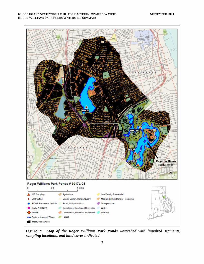
presented in Figure 2 with land use types indicated.
The Roger Williams Park Ponds are located in Roger
Williams Park in the City of Providence, a large Victorian
park that offers manicured grounds, an extensive roadway
system, a zoo, museum, and other facilities. The ponds are
bounded by Interstate 95 and Elmwood Avenue (Route 1)
to the west, Broad Street and Warwick Avenue (Route 117)
to the east, and Park Avenue (Route 12) to the south. The
pond system is comprised of a series of hydrologically
interconnected lakes including Roosevelt, Polo, Willow,
Pleasure, Edgewood, Cunliff, and Elm. The main inlet to
the ponds, located at the western edge of Roosevelt Lake, is
culverted flow from Mashapaug Pond, another bacteria
impaired waterbody, which is located just northwest of the
park. There are no surface tributaries to the ponds. The
main outlet of the pond system is located at the dam at the
southern end of Elm Lake (RIDEM, 2007).
The Roger Williams Park Ponds watershed covers 4 square
miles. As shown in the aerial image of Figure 3, developed
areas (including residential, commercial, and transportation
uses) occupy a large portion (81%) of the watershed. Non-
developed uses cover approximately 9%, wetlands and
other surface waters occupy 9%, and other land uses
combine to cover 1%. Impervious surfaces cover a total of
58%.
Roger Williams Park Ponds
Assessment Unit Facts (RI0006017L-05)
Town: Providence Impaired Segment Size:
76 acres Classification: Class B Direct Watershed:
4 mi2 (2589 acres) Impervious Cover: 57.8% Watershed Planning
Area: Pawtuxet (#12)
Watershed Land Uses
Developed (81%)
Non-Developed
(9%) Water/Wetlands (9%)
Other (1%)

RHODE ISLAND STATEWIDE TMDL FOR BACTERIA IMPAIRED WATERS SEPTEMBER 2011
ROGER WILLIAMS PARK PONDS WATERSHED SUMMARY
2
Figure 1: Map of the Pawtuxet Watershed Planning Area with impaired segments
addressed by the Statewide Bacteria TMDL, sewered areas, and stormwater regulated zones.
Roger Williams
Park Ponds
Roger Williams
Park Ponds
RHODE ISLAND STATEWIDE TMDL FOR BACTERIA IMPAIRED WATERS SEPTEMBER 2011
ROGER WILLIAMS PARK PONDS WATERSHED SUMMARY
3
Figure 2: Map of the Roger Williams Park Ponds watershed with impaired segments,
sampling locations, and land cover indicated.
Roger Williams
Park Ponds
RHODE ISLAND STATEWIDE TMDL FOR BACTERIA IMPAIRED WATERS SEPTEMBER 2011
ROGER WILLIAMS PARK PONDS WATERSHED SUMMARY
4
Why is a TMDL Needed?
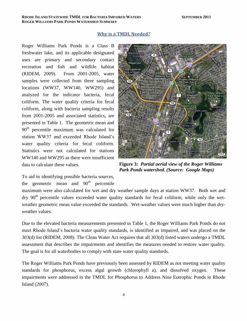
Roger Williams Park Ponds is a Class B
freshwater lake, and its applicable designated
uses are primary and secondary contact
recreation and fish and wildlife habitat
(RIDEM, 2009). From 2001-2005, water
samples were collected from three sampling
locations (WW37, WW140, WW295) and
analyzed for the indicator bacteria, fecal
coliform. The water quality criteria for fecal
coliform, along with bacteria sampling results
from 2001-2005 and associated statistics, are
presented in Table 1. The geometric mean and
90th
percentile maximum was calculated for
station WW37 and exceeded Rhode Island’s
water quality criteria for fecal coliform.
Statistics were not calculated for stations
WW140 and WW295 as there were insufficient
data to calculate these values.
To aid in identifying possible bacteria sources,
the geometric mean and 90th
percentile
maximum were also calculated for wet and dry weather sample days at station WW37. Both wet and
dry 90th
percentile values exceeded water quality standards for fecal coliform, while only the wet-
weather geometric mean value exceeded the standards. Wet-weather values were much higher than dry-
weather values.
Due to the elevated bacteria measurements presented in Table 1, the Roger Williams Park Ponds do not
meet Rhode Island’s bacteria water quality standards, is identified as impaired, and was placed on the
303(d) list (RIDEM, 2008). The Clean Water Act requires that all 303(d) listed waters undergo a TMDL
assessment that describes the impairments and identifies the measures needed to restore water quality.
The goal is for all waterbodies to comply with state water quality standards.
The Roger Williams Park Ponds have previously been assessed by RIDEM as not meeting water quality
standards for phosphorus, excess algal growth (chlorophyll a), and dissolved oxygen. These
impairments were addressed in the TMDL for Phosphorus to Address Nine Eutrophic Ponds in Rhode
Island (2007).
Figure 3: Partial aerial view of the Roger Williams
Park Ponds watershed. (Source: Google Maps)
RHODE ISLAND STATEWIDE TMDL FOR BACTERIA IMPAIRED WATERS SEPTEMBER 2011
ROGER WILLIAMS PARK PONDS WATERSHED SUMMARY
5
Potential Bacteria Sources
There are several potential sources of bacteria in the Roger Williams Park Ponds watershed including
stormwater runoff, animal waste, and sewer system leaks. The 2007 TMDL for Phosphorus to Address
Nine Eutrophic Ponds in Rhode Island identified inputs from Mashapaug Pond (another impaired
waterbody), stormwater runoff, and fecal-related nutrients from waterfowl and wildlife as the most
significant sources of phosphorus to the Roger Williams Park Pond system. These sources may also be
contributing to bacterial contamination of the Roger Williams Park Ponds.
Developed Area Stormwater Runoff
The Roger Williams Park Ponds watershed has an impervious cover of approximately 58%. Impervious
cover is defined as land surface areas, such as roofs and roads, that force water to run off land surfaces,
rather than infiltrating into the soil. Impervious cover provides a useful metric for the potential for
adverse stormwater impacts. As discussed in Section 6.3 of the Core TMDL Document, as a general
rule, impaired streams with watersheds having higher than 10% impervious cover are assumed to be
affected by stormwater runoff.
In accordance with Phase II requirements and as part of the work for the 2007 TMDL for Phosphorus to
Address Nine Eutrophic Ponds in Rhode Island, all stormwater outfalls discharging directly to the Roger
Williams Park Pond system have been identified and mapped by the City of Providence and the Rhode
Island Department of Transportation (RIDOT). Twenty-four storm drains and two areas of concentrated
surface flow have been identified. These outfalls were shown to carry stormwater from both high-
density residential areas near the park and from the park itself (RIDEM, 2007). As stormwater is known
to carry a suite of pollutants, including bacteria, it is a likely source of bacteria to the Roger Williams
Park Ponds.
Waterfowl, Wildlife, and Domestic Animal Waste
The Roger Williams Park Ponds watershed is predominately developed, with a combination of
residential, commercial, and transportation uses. Waste from domestic animals such as dogs, may be
contributing to bacteria concentrations in the pond system.
Though the watershed is highly developed, the area surrounding the ponds is predominately forested or
maintained lawn. Many of these areas are home to multiple species of wildlife and waterfowl. Wildlife,
including waterfowl, may be a significant bacteria source to surface waters. With the construction of
roads and drainage systems, these wastes may no longer be retained on the landscape, but instead may
be conveyed via stormwater to the nearest surface water. As such these physical land alterations can
exacerbate the impact of these natural sources on water quality. Large populations of ducks and geese

RHODE ISLAND STATEWIDE TMDL FOR BACTERIA IMPAIRED WATERS SEPTEMBER 2011
ROGER WILLIAMS PARK PONDS WATERSHED SUMMARY
6
have been shown to congregate in many of these areas (RIDEM, 2007; Fuss and O’Neill, 2004). Several
of these ponds also have extensive areas of eroded shoreline. The Roger Williams Park Zoo is also
located near the pond system and is a potential bacteria source to the Roger Williams Park Ponds
systems.
Sewer Leaks
The Roger Williams Park Ponds watershed is completely sewered, as shown in Figure 1. Sewer system
leaks and other illicit discharges near the ponds are possible based on dry-weather bacteria data
(Table 1). Municipal wastewater is treated within the Narragansett Bay Commission system and
discharged to the Providence River. The extensive sewage collection system within the watershed
increases the risk of sewer system leaks and subsequent contamination.
Existing Local Management and Recommended Next Steps
Additional bacteria data collection would be beneficial to support identification of sources of potentially
harmful bacteria in the Roger Williams Park Ponds watershed. These activities could include sampling
at several different locations and under different weather conditions (e.g., wet and dry). Field
reconnaissance surveys focused on buffers, stormwater runoff, and other source identification may also
be beneficial.
Based on existing ordinances and previous investigations, the following steps are recommended to
support water quality goals.
Stormwater Management
The City of Providence (RIPDES permit RIR040005) and RIDOT (RIPDES permit RIR040036) are
municipal separate storm sewer (MS4) operators in the Roger Williams Park Ponds watershed and have
prepared the required Phase II Stormwater Management Plans (SWMPP). The entire watershed area is
regulated under the Phase II program.
Providence’s SWMPP outlines goals for the reduction of stormwater runoff to the Roger Williams Park
Ponds through the implementation of Best Management Practices (BMPs). Many of these BMPs are
now in place, including mapping all stormwater outfalls, instituting annual inspections and cleaning of
the town’s catch basins, implementing an annual street sweeping program, adopting construction erosion
and sediment control and post-construction stormwater control ordinances, and conducting public
education activities (RIDEM, 2010a).

RHODE ISLAND STATEWIDE TMDL FOR BACTERIA IMPAIRED WATERS SEPTEMBER 2011
ROGER WILLIAMS PARK PONDS WATERSHED SUMMARY
7
The City of Providence adopted an illicit discharge detection and elimination ordinance in 2005
(RIDEM, 2010a). These ordinances prohibit illicit discharges to the MS4 and provide an enforcement
mechanism. The city should continue to select priority areas to identify and eliminate illicit discharges
in the Roger Williams Park Ponds watershed. Illicit discharges can be identified through continued dry
weather outfall sampling and microbial source tracking.
RIDOT also has completed a SWMPP for state-owned roads in the watershed. RIDOT’s SWMPP and
its 2011 Compliance Update outline its goals for compliance with the General Permit statewide. It
should be noted that RIDOT has chosen to enact the General Permit statewide, not just for the urbanized
and densely populated areas that are required by the permit. RIDOT has finished mapping its outfalls
throughout the state and is working to better document and expand its catch basin inspection and
maintenance programs along with its BMP maintenance program. Stormwater Pollution Prevention
Plans (SWMPPs) are being utilized for RIDOT construction projects. RIDOT also funds the University
of Rhode Island Cooperative Extension’s Stormwater Phase II Public Outreach and Education Project,
which provides participating MS4s with education and outreach programs that can be used to address
TMDL public education recommendations.
While these first steps are important in reducing the effects of stormwater runoff to the Roger Williams
Park Ponds, additional efforts are needed to restore the river’s water quality. As mentioned previously,
the Roger Williams Park Ponds watershed has an impervious cover of 58%, a level where stormwater
impacts are expected. At this threshold, RIDEM is requiring the MS4 operators to revise their post-
construction stormwater ordinances as described in Section 6.3 of the Core TMDL Document.
Providence and RIDOT should also evaluate whether the six minimum measures alone are sufficient to
meet the bacteria reduction targets. Per Part IV.D of the General Permit, the MS4 operators should
ensure that their minimum measures are consistent with the recommendation of Section 6.2 of the Core
TMDL Document. Changes to the SWMPPs should be documented in a TMDL Implementation Plan
(TMDL IP) and should comply with relevant provisions Part IV.D of the RIPDES Stormwater General
Permit (RIDEM, 2010b), which are summarized in Section 6.2 (Numbers 1 through 5) of the Core
TMDL Document.
In addition, the Eutrophic Ponds TMDL (2007) determined that structural BMPs are necessary to
improve water quality in the Roger Williams Park Ponds. RIDEM identified priority outfalls for
treatment in Table 4.4 of the Eutrophic Ponds TMDL document. The BMPs should be designed to
target bacterial pollution reduction as well as phosphorus reductions. Further information can be found
in the Eutrophic Ponds TMDL. One TMDL IP may be submitted to address both bacteria and
phosphorus TMDL requirements.

RHODE ISLAND STATEWIDE TMDL FOR BACTERIA IMPAIRED WATERS SEPTEMBER 2011
ROGER WILLIAMS PARK PONDS WATERSHED SUMMARY
8
Priority Outfalls for Roger Williams Park Ponds (Table 4.4 in the 2007 Eutrophic Ponds TMDL)
Outfall
ID Location Possible Ownership
1
RWP-Q 48” Diameter. Eastern End Roosevelt Lake Providence, RIDOT, Cranston
RWP-S 48” Diameter. Eastern Shore Willow Lake Providence
RWP-V 74” x 24” Box Culvert. Eastern Shore Polo Lake Providence
RWP-H 30” x 42” Oval Culvert. Southern End Edgewood Lake Providence
RWP-A 24” Diameter. Northern End Pleasure Lake Providence
RWP-D 24” Diameter. Eastern End Pleasure Lake Providence
RWP-I 24”Diameter. Southern End Edgewood Lake Providence
RWP-U 24” Diameter. Northern End Polo Lake Providence 1
Ownership inferred from proximity to state or local roadways.
The City of Providence should continue to implement the goals of its Phase II SWMPP including dry-
weather sampling, extensive street and catch basin cleaning, and public education activities. The city
has recently hired a contractor to undertake the Roger Williams Park Ponds restoration project. The
overall goal of the project is to restore and improve both water quality and biodiversity in the 100-acre
urban pond complex. The project will develop a strategy for restoring the ponds, including structural
and non-structural BMPs both within the park as well as the watershed extending beyond the park
boundary. RIDOT should also continue to implement its Phase II SWMPP.
Waterfowl, Wildlife, and Domestic Animal Waste
The City of Providence has multiple programs in place to decrease problems from animal waste.
Section 4-27 of Providence’s City Ordinance requires owners to properly dispose of pet waste.
Violating this law is punishable through fines. The city also has a leash law in public spaces and
signage and dog-waste receptacles in many public places throughout the watershed (Fuss and O’Neill,
2004). The Roger Williams Park Zoo is also located near the ponds. RIDEM should continue to ensure
that waste from the multiple animals within the zoo is being be handled and disposed of properly. Due to
the concentration of residential neighborhoods, parks, and the zoo adjacent to the Roger Williams Park
Ponds, further efforts should be taken to limit bacterial contributions from animal waste to the ponds.
Education and outreach programs should highlight the importance of picking up after dogs and other
pets and not feeding waterfowl. Animal wastes should be disposed of away from any waterway or
stormwater system. The city should work with volunteers to map locations where animal waste is a
significant and chronic problem. This work should be incorporated into the municipalities’ Phase II
plans and should result in an evaluation of strategies to reduce the impact of animal waste on water
quality. This may include installing additional signage, providing more pet waste receptacles or pet
waste digester systems in high-use areas, enacting stricter ordinances requiring clean-up of pet waste,
and targeting educational and outreach programs in problem areas.

RHODE ISLAND STATEWIDE TMDL FOR BACTERIA IMPAIRED WATERS SEPTEMBER 2011
ROGER WILLIAMS PARK PONDS WATERSHED SUMMARY
9
Large populations of ducks and geese have been shown to congregate in the Roger Williams Park Pond
system (RIDEM, 2007; Fuss and O’Neill, 2004). The city and residents can take several measures to
minimize bird-related impacts. They can allow tall, coarse vegetation to grow in areas along the shores
of the Roger Williams Park Ponds that are frequented by waterfowl. Waterfowl, especially grazers like
geese, prefer easy access to the water. Maintaining an uncut vegetated buffer along the shore will make
the habitat less desirable to geese and encourage migration. With few exceptions, Part XIV, Section
14.13, of Rhode Island’s Hunting Regulations prohibits feeding wild waterfowl at any time in the state
of Rhode Island. Educational programs should emphasize that feeding waterfowl, such as ducks, geese,
and swans, may contribute to water quality impairments in the Roger Williams Park Ponds and can harm
human health and the environment.
Land Use Protection
Woodland and wetland areas within the Roger Williams Park Ponds watershed absorb and filter
pollutants from stormwater runoff, and help protect water quality. As these areas represent only a small
portion of the land use in the Roger Williams Park Ponds watershed, it is important to preserve these
sparse undeveloped areas, and institute controls on development in the watershed.
The steps outlined above will support the goal of mitigating bacteria sources and meeting water quality
standards in the Roger Williams Park Ponds.

RHODE ISLAND STATEWIDE TMDL FOR BACTERIA IMPAIRED WATERS SEPTEMBER 2011
ROGER WILLIAMS PARK PONDS WATERSHED SUMMARY
10
Table 1: Roger Williams Park Ponds Bacteria Data
Waterbody ID: RI0006017L-05
Watershed Planning Area: 12 – Pawtuxet
Characteristics: Freshwater, Class B, Primary and Secondary Contact Recreation, Fish and Wildlife
Habitat
Impairment: Fecal coliform (MPN/100mL)
Water Quality Criteria for Fecal Coliform:
Geometric Mean: 200 MPN/100 mL
90th
Percentile: 400 MPN/100 mL
Percent Reduction to meet TMDL: 100% (Includes 5% Margin of Safety)
Data: 2001-2005 from RIDEM
Single Sample Fecal Coliform (MPN/100 mL) Results for Roger Williams Park Ponds (2001-2005)
with Geometric Mean and 90th
Percentile Statistics
Station
Name
Station
Location Date Result Wet/Dry
Geometric
Mean 90th Percentile
WW295 Elm Pond 7/20/2005 16 Dry NA NA
WW37 Cunliff’s Pond 7/18/2003 20 Wet
210 8130
†
(100%)*
WW37 Cunliff’s Pond 5/3/2003 0 Dry
WW37 Cunliff’s Pond 10/17/2002 985 Wet
WW37 Cunliff’s Pond 7/25/2002 760 Dry
WW37 Cunliff’s Pond 5/4/2002 350 Dry
WW37 Cunliff’s Pond 10/18/2001 550 Dry
WW37 Cunliff’s Pond 7/26/2001 530 Wet
WW37 Cunliff’s Pond 6/23/2001 24800 Wet
WW140 Pleasure Pond 7/20/2005 100 Dry NA NA
Shaded cells indicate an exceedance of water quality criteria
* Includes a 5% Margin of Safety †90
th percentile used to determine percent reduction
RHODE ISLAND STATEWIDE TMDL FOR BACTERIA IMPAIRED WATERS SEPTEMBER 2011
ROGER WILLIAMS PARK PONDS WATERSHED SUMMARY
11
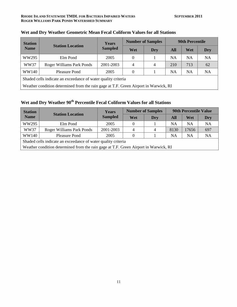
Wet and Dry Weather Geometric Mean Fecal Coliform Values for all Stations
Station
Name Station Location
Years
Sampled
Number of Samples 90th Percentile
Wet Dry All Wet Dry
WW295 Elm Pond 2005 0 1 NA NA NA
WW37 Roger Williams Park Ponds 2001-2003 4 4 210 713 62
WW140 Pleasure Pond 2005 0 1 NA NA NA
Shaded cells indicate an exceedance of water quality criteria
Weather condition determined from the rain gage at T.F. Green Airport in Warwick, RI
Wet and Dry Weather 90th
Percentile Fecal Coliform Values for all Stations
Station
Name Station Location
Years
Sampled
Number of Samples 90th Percentile Value
Wet Dry All Wet Dry
WW295 Elm Pond 2005 0 1 NA NA NA
WW37 Roger Williams Park Ponds 2001-2003 4 4 8130 17656 697
WW140 Pleasure Pond 2005 0 1 NA NA NA
Shaded cells indicate an exceedance of water quality criteria
Weather condition determined from the rain gage at T.F. Green Airport in Warwick, RI
RHODE ISLAND STATEWIDE TMDL FOR BACTERIA IMPAIRED WATERS SEPTEMBER 2011
ROGER WILLIAMS PARK PONDS WATERSHED SUMMARY
12
References
Fuss and O’Neill, Inc. (2004). Phase II Stormwater Management Plan. City of Providence Rhode
Island. March 2004.
RIDEM (2007). TMDL for Phosphorus for Nine Eutrophic Ponds in Rhode Island. Rhode Island
Department of Environmental Management.
RIDEM (2008). State of Rhode Island and Providence Plantations 2008 303(d) List – List of Impaired
Water Bodies. Rhode Island Department of Environmental Management.
RIDEM (2009). State of Rhode Island and Providence Plantations Water Quality Regulations. Amended
December, 2009. Rhode Island Department of Environmental Management.
RIDEM (2010a). MS4 Compliance Status Report for RI Statewide Bacteria TMDL. Rhode Island
Department of Environmental Management.
RIDEM (2010b). Total Maximum Daily Load Analysis for the Pawcatuck River and Little Narragansett
Bay Waters (Bacteria Impairments. Rhode Island Department of Environmental Management.
RI HEALTH (2003). Aquidneck Island Drinking Water Assessment Results, Source Water Protection
Assessment conducted by the University of Rhode Island for the Rhode Island Department of
Health, Office of Drinking Water Supply.
USEPA (2002). Onsite Wastewater Treatment Systems Manual – Office of Water, Office of Research
and Development – EPA/625/R-00/008. Online:
www.epa.gov/owm/septic/pubs/septic_2002_osdm_all.pdf.