Embed Size (px)
Citation preview


ROGER DUHAMEL, F.R.S.C. QUEEN’S PRINTER AND CONTROLLER OF STATIONERY
OTTAWA, 1961’
Cat. No. A57-417

ACKNOWLEDGMENTS The British Columbia Department of Agriculture surveyed the soils of the
Upper Columbia River valley. The Water Resources Branch, Department of Northern Affairs and National Resources, provided financial assistance, maps and aerial photographs. The Provincial Department of Lands and Forests also supplied maps and data. The Provincial Department of Mines provided chemical analyses. The Canada Department of Agriculture drafted the final copy of the soi1 map for lithographing and published this report.
Dr. A. Leahey, Research Branch, Canada Department of Agriculture, assisted in the classification and correlation of the soils and critically reviewed the manuscript.
Over a number of years the soils were mapped by P. N. Sprout, A. J. Green, A. L. van Ryswyk, J. D. Lindsay and J. S. D. Smith.
The late Dr. W. E. Cockfield, Geological Survey of Canada, made annual field visits and provided information regarding the deposits from which the soils were derived.
Mr. A. McLean, Ecologist, Canada Range Experimental Farm, Kamloops, wrote the section on native vegetation.
Dr. C. A. Rowles, Professor of Soi1 Science, University of British Columbia,. made field visits and gave valuable advice.
The British Columbia Department of Agriculture Reclamation Committee, of which the senior author is secretary, estimated the farm duty of water of each potentially irrigable soi1 type.
Mr. J. W. Awmack, District Agriculturist, Cranbrook, and other officiais of the British Columbia and Canada departments of agriculture provided advice, descriptive material, and other assistance.
3 96489-O-l&


CONTENTS
PAGE
LIST OF ILLUSTRATIONS ........................................ 7
LISTOFTABLES .................................................. 7
ACKNOWLEDGMENTS ............................................ 3
INTRODUCTION . . . . . . . . . . . . . . . . . . . . . . . . . . . . . . . . . . . . . . . . . . . . . . . . . . . 9
GENERAL DESCRIPTION OF THE AREA Location and Extent ........................................... 11. History and Development ....................................... 11 Towns, Population and Industries ................................ 12 Schools, Churches and Communications .......................... 13 Transportation ................................................. 14 Agriculture ........................ . ........................... 14 Climate ........................................................ 17 Native Vegetation .............................................. 21 Physiography .................................................. 25 Drainage ....................................................... 25 Geology of Soi1 Parent Materials ................................. 26 .
SOILS Field Methods ................................................. 30 Soi1 Development .......................... . ................... 30
Soi1 Classification .............................................. 33
DESCRIPTIONS OF SOILS
1. Dark Brown Soils .............................................. 35 Saha Loam ............. . . ................................. 35
2. Brown Wooded Soils ............................................ 37
~ Wyclifie Silt Loam ......................................... 37 ’ Elko Loam ................................................ 39
Misko Loam ............................................... 41 Flagstone Loamy Sand ...................................... 42 Mayook Silt Loam .......................................... 44 Nokie Series ................................................ 46 Lakit Sandy Loam ......................................... 48

PAGE
3. Gray Wooded Soils . . . . . . . . . . . . . . . . . . . . . . . . . . . . . . . . . . . . . . . . . . . . . 49 Kinbasket Silt Loam . . . . . . . . . . . . . . . . . . . . . _ . . . . . . . . . . . . . . . . . 50 Cedrus Loam . . . . . . . . . . . . . . . . .._...._...................... 52 Brisco Silty Clay Loam . . . . . . . . . . . , . . . _ . . . . . . . . . . . . . . . . . . . . . 54 WaptaSilt-Loam . . . . . . . . . . . . . . . . . . . . . . . . . . . . . . . . . . . . . . . . . . . 55 Madias Silty Clay Loam . _ . . . . . . . . . . . _ _ . . . . . . . . . . . . . . . . . . . . . 56 Nestor Loam . . . . . . . . . . . . . . . . . . . . . . . . . . . . . . . . . . . . . . . . . . . . . . 58
4. Podzolized Gray Wooded Soils . _ . . , . , . . . . . . _ . _ . . . . . . . . . . . . . . . . . . . 59 Yoho Clay Loam ..___..................................,... 60 Bugaboo Silt Loam _.........................___........... 63 Dogtooth Sandy Loam . . . . . . . . . . . . . . . . . . . . . . . . . . . . . . . . . . . . . . 64 Narboe Sandy Loam . . . . . . . . . . . . . . . . . . . . . . . . . .._........... 66 Wonah Sandy Loam .._.................._................. 6’7 Palliser Very Fine Sandy Loam . . . . . . . . . . . . . . . . . . . . . . . . . . . . . 68 Purcell Silt Loam . . . . . . . . . . . . . . . . . . . _ . . . _ _ . . . . . . . . . . . _ . . . . . 70 Blaeberry Silty Clay Loam . . . . . . . . . _ _ . . . . . . _ . . . . . . . . . . . . . . . . 71 Golden Sandy Loam . . . . . . . . . . . . . . . . . . . . . . . . . . . . . . . . . . . . . . . . 73
5. The Wigwam Soi1 Complex . . . . . . . . . . . . . . . . . . . . . _ . . . . . . . . . . . . . . . . 74
6. Regosolic Soils . . . . . . . . . _ _ . , . . . . . . . . . . . . . . . . . . . . . . . . . . . . . . . . . . . . . 77
McMurdo Sandy Loam . . . . . . . . . . . . . . . . . . . . . . . . . . . . . . . . . . . . . 77 Hamber Sandy Loam . . . . . . . . . . . . . . . . . . . . . . . . . . . . . . . . . . . . . . . 78 Nowitka Soi1 Complex . . . . . . . . . . . . . . . . , . . . . . . . _ . . . . , _ _ . . . . . . 80
7. Organic Soils Deep Peat ,................................................ 84
8. Miscellaneous Areas Rough Mountainous Land . . . . . . . . . . . . . . . . . . . . . . . . . . . . . . . . . . . 84 Rock Outcroppings ..,...................................... 85 Bluffs and Ravines . . . . . . . . . . . . . . . . . . . . . . . . . . . . . . . . . . . . . . . . . 85 Swamp .,.........___....._.......,.._,.........__.....__.. 85 Ponds . . . . . . . . . . . . . . . . . . . . . . . . . . . . . . . . . . . . . . . . . . . . . . . . . . . . . 85 Lakes . . . . . . . . . . . . . . . . . . . . . . . . . . . . . . . . . . . . . . . . . . . . . . . . . . . . . 85
APPROXIMATE ACREAGES OF VARIOUS SOILS AND OTHER AREAS 85
CLASSIFICATION ACCORDING TO SUITABILITY FOR IRRIGATION . 85 SOIL MANAGEMENT . .._....._._...._........................._._ 88 CHEMICAL ANALYSES . . . . . . . . . . . . . . . . . . . . . . . . . . . . ..__....__..... 88 MINOR ELEMENTS . . ..<.__......................<.__...._........ 95 OTHER METALLIC ELEMENTS < _ _ . . . . . . . . . . . . . . . . . _ . . . . . _ . . . . . . . 96 PHYSICAL ANALYSES . . . . . . . . . . . . . . . . . . . . . . . . . . . . . . . . . . . . . . . . . . . . 98
APPENDIX TABLES . . _ . . . . . . . . . . . . . . . _ _ . . . . _ . . . . _ . . . . . . . . . . . 101 GLOSSARY . . . . . . . . . . .._.......................................... 103

7
LIST OF ILLUSTRATIONS FIGURE , PAGE
1. Map of British Columbia showing location of soil-surveyed areas . . . 4
2. Lake Windermere . . . . . y. . . . . . . , . . . . . . . . . . . . . . . . . . . . _ . . . . . . . . . . . 13 3. Monthly precipitation patterns . . . . . . . . . . . . . . . . . . . . . . . . . . . . . . . . . . 20
4. Representative soi1 profiles . . . . . . . . . . . . . . . . . . . . . . . . . . . . . . . . . . . . . 32 5. Elko-Saha soils and the Purcell Mountains . . . . . . . . . . . . . . . . . . . . . . . 35
6. Irrigated Wycliffe silt loam . . . . . . . . . . . , . ;. . . . . . . . . . . . . . . . . . . . . . . 38
7. Flagstone loamy Sand, duned phase . . . . . . . . . . . . . . . . . . . . . . . . . . . . . . . 43
8. Mayook silt loam bordering Columbia Lake . . . . . . . . . . . . . . . . . . . . . . . . 45
9. Farmstead on Yoho clay loam . . . . . . . . . . . . . . . . . . . . . . . . . . . . . . . . . . 61 10. Topography and vegetation, Blaeberry silty clay loam . . . . . . . . . . . . 71
11. Nowitka soils, Columbia River flats . . . . . . . . . . . . . . . . . . . . . . . . . . . . . . 80
12. Soi1 textural classes . . . . . . . . . . . . . . . . . . . . . . . . . . . . . . . . . . . . . . . . . . . . 106
LIST OF TABLES TABLE PAGE
1. Average seasonal temperatures .................................. 18
2. Extreme temperatures and average snowfall ..................... 19
3. High and low precipitation ..................................... 19 4. Classification of soils ........................................... 34
5. Approximate acreages of soils ................................... 86
6. Acreages of soils according to suitability for irrigation .............. 8’7
7. Total percentages of nitrogen and phosphorus and pH in seven soi1 profiles .................................................... 89
8. Total percentages of calcium, magnesium, potassium, and sodium in six soi1 profiles ............................................ 91
9. Total percentages of silica and sesquioxides in six soi1 profiles ...... 93 10. Exchange capacity, percentage base saturation and exchangeable
cations in ten soi1 profiles ................................... 94
11. Boron, cobalt and manganese in parent materials of four Brown Woodedsoils ............................................... 96
12. Metallic elements in three soi1 profiles ............................ 97 13. Particle size distributions and textural classes in three Brown Wooded
soils ...................................................... 98 14. Particle size distributions and textural classes in five Gray Wooded
soils.. ..................................................... 99 15. Particle size distributions and textural classes in five Podzolized Gray
Wooded soils ......... .‘., .................................. 100 A Average monthly and annual temperatures ....................... 101
B Frost-free periods .............................................. 101 C ANerage monthly and annual precipitation .............. + ......... 102

INTRODUCTION This is the seventh of a series of reports describing the soils of British
Columbia. The soi1 surveys are co-operative projects, the main participants being the British Columbia and Canada departments of agriculture and the University of British Columbia. Other departments of the Canada and British Columbia governments also assisted when mutual interests existed in the areas being sur’veyed. Each report is complete in itself. TO present information on soils is the primary purpose, but subjects that have a bearing on the nature and ‘utilization of the soils are included.
The Upper Columbia River vahey is in a pioneer stage of agricultural development because of the dry summer climate and the need of irrigation. Although there may not be further development of irrigated agriculture in the area for some time, the valley was surveyed to establish a- right to water for the irrigable land before assignment of water-for international storage and hydroelectric power. The soils were surveyed for suitability for irrigation as well as in a detailed reconnaissance. Land class and soi1 maps were prepared but only the soi1 map is included in this report.
Table 5 gives the acreages of the different soi1 types and the amounts suit- able for agriculture. In Table 6 is shown the suitability of the soi1 types for irrigation farming. Up to now the irrigated land has been limited to small acreages that could be developed at comparatively low cost.
The surveyed area has many resources and attractions. Tourists find the scenery outstanding, and each year increasing numbers pass through the country to and from the nearby national parks. The climate is characterized by dry summers and clear air. In the area are valuable minerals, timber and game.
Four soi1 maps on a scale of one inch to one mile accompany this report. The soils are differentiated by symbols and colors as explained in the legends.
9 964894-2

-
GENERAL, DESCRIPTION OF THE AREA
Location and Extent
The surveyed part of the Upper Columbia River valley is in the Rocky Mountain Trench between Canal Flats, 50”09’ north latitude, 114”56’ west longitude, and Bluewater Creek, 51”32’ latitude, 117’16’ longitude. In a11 the valley is about 140 miles long. This area consists of the Columbia River bottoms and higher ground bounded on the east by the Stanford, Brisco and Van Horne ranges of the Rockies and on the west by the Purcell Mountains. South of Spilli- macheen the valley is from two to eight miles wide. Northward and downstream the average width is about two miles. The areas of soils surveyed total 274,314 acres.
History and Development
David Thompson, the first white man to explore the district, came from Rocky Mountain House, Alberta, in 1807. He entered the valley by way of
the Blaeberry River, and established “Kootenae House” as a trading post. A cairn near Athalmer marks the site of Kootenae House, and a replica of the main building and stockade is located near Invermere.
The first commerce in the area was the fur trade with the local Indians, who trapped mainly beaver, marten, mink and muskrat. The fur harvest is valued now at about $50,000 annually.
In 1862 placer gold was found in Findlay Creek, near Canal Flats; many prospectors entered from the south and worked north along the Columbia River to explore the gravels of tributary streams. Railway construction in 1883 opened up lumbering and iode mining industries.
In the 1890’s many mining claims were staked in the Purcell Mountains, between Canal Flats and Beavermouth. Some are still active, such as the Paradise, Lead Queen, Pretty Girl, White Cat, Grotto, Lookout and Minera1 King, west and north of Invermere. In the Spillimacheen area are the Toronto, Alpha, Ruth-Vermont, Giant Mascot and others. The minerals commonly found are lead, zinc, silver, copper, gold and barite, often as complex ores.
In the nearby Rocky Mountains similar ores were found in the Kicking Horse and Monarch claims near Field. The Monarch, the first galena prospect in British Columbia, was staked in 18’79 and is now an operating mine. An enormous deposit of gypsum,was four-id in the Stanford Range to the east of Windermere, and is also mined.
In 1884 the Golden Lumber Company started to operate a sawmill. ,Another mil1 started at Golden in 1907 and continued operations until 1928; it produced up to 250,000 board feet of lumber per shift. This company built 29 miles of logging railways, but was forced to close down after a forest fire in 1926 destroyed most of its standing timber.
In 1883 the first homestead in the Golden area was pre-empted by a man employed at railway construction. In 1884 the Elkhorn Ranch was established near Windermere, and it was used as an experimental station of the Canada Department of Agriculture from 1923 to 1939.
11 96489-O-2-J

12
Towns, Population and Industries
In 1882, the construction camp of the Canadian Pacifie Railway at the junction of the Columbia and Kicking Home rivers was called “The Cache”, afterwards Golden City, and in 1886 was named Golden. It had a population of 340 in 1889 and 1,450 in 1921. This figure included about 500 men employed in lumbering camps. In 1952 Golden had a population of 827.
Golden, unincorporated at the time of the survey (1954), had a 16-bed hospital, a provincial government office, and an electric system. The first elec- tricity was supplied in 1906 by a lumber mill. This utility was taken over by the British Columbia Power Commission in 1947 and a diesel plant of 721-h.p. capacity was installed. In 1956 the diesel plant was supplanted by hydro- electric power from Spillimacheen.
In 1915 a creamery opened at Golden but was closed in 1953 because of too little milk production in the area. A dairy, organized in 1950, is the only one between Golden and Kimberley. It distributes about 2,000 gallons of milk daily in the district. The raw milk is produbed by 13 dairy farmers. The town is supported chiefly by railway, lumbering and government services, and the tourist trade. There are large sawmills at Donald and Parson, where the populations are 143 and 186 respectively.
TO the south, Spillimacheen, at the junction of the Spillimacheen and Columbia rivers, has a trading post, a railway station, and a local population of about 136. From here a 5,000-h.p. hydro-electric plant and the Giant Mascot mine may be reached.
William Thompson was the first settler in Edgewater, in 190’7, and the townsite was surveyed in 1909 to serve an irrigated area. Edgewater is now a small village, served with electricity from Spillimacheen and domestic water from Baptiste Lake. Supported by the produce from a few hundred acres of irrigated land, lumber, Christmas tree sales and the tourist trade, the population of this area is 383.
Radium, in Kootenay National Park, just above Sinclair Canyon, has hot springs with elaborate facilities. Since the first bath was built in 1908, Radium has been a leading attraction of the Rocky Mountain national parks system. About 110 people live permanently in or near Radium.
Invermere, incorporated as a village in 1951, has a population of about 400. It has an Il-bed hospital, medical service, a bank, a theatre, hotels, domestic light and water. Invermere is an administrative and distributing tenter for the area between Brisco and Canal Flats.
Athalmer, with about 178 people, adjoins Invermere on the east. It is situated in the Columbia River bottomland on the fan of Toby Creek, at the north end of Lake Windermere. Wilmer, population 134, lies a mile or more north of Invermere. Windermere, local population 240, is an important stopping place for tourists, and there are many motels in this area on the east side of Lake Windermere.
Between Windermere and Canal Flats are motels for tourists at Fairmont Hotsprings and around Dutch Creek. Canal Flats is a small village of about 300 people engaged mainly in lumbering, in the valley bottom between Kootenay River and Columbia Lake.
The main mine in the area is the Giant Mascot, which in 1953 produced 176,000 tons of ore, containing 110,981 ounces of silver, 11,584,827 pounds of lead and 1,029,348 pounds of zinc. In 1953 Columbia Gypsum Products Ltd. produced 60,234 tons of gypsum from a mine east of Windermere. Other mines in the area are not producing. In 1952, lumber shipments from the mapped area totalled 803 carlots, and 15,808 Christmas trees were harvested.

The magnificent scenery of the national parks nearby and of the district appeals to tourists, for whom accommodations at Golden and around Winder- mere and Radium are expanding. There is an influx of hunters in the fa11
Figure 2. Lake Windermere.
after game, which includes grizzly and black bears, elk, moose, mountain sheep and goats, white-tailed and mule deer, grouse, ducks and geese. In particular, deer and elk are plentiful, but wary at low altitudes.
In 1954 the population of the whole mapped area was about 5,000.
Schools, Churches and Communications
The first school in the area opened at Golden in 1886, and additions were made in 1899, 1910 and 1953. There is one senior high school at Golden and two serve the locality of Invermere. Fourteen elementary schools are distributed throughout the mapped area; the school population was 884 in 1954.
Various religious denominations are represented at Golden and Invermere, and church buildings are scattered in the smaller communities. In 1887 Donald became the government and religious tenter for the interior of the province east of Kamloops. The first church was built at Donald. This was the “stolen church”, which later was moved to Golden by railway and by barge to the Shuswap Indian Reserve between Radium and Invermere, where it is still in use.
Telephone lines follow the main line of the Canadian Pacifie Railway east and west and the highway from Golden to Canal Flats; the main exchange is at Golden. The railway has an east-west and north-south telegraph system. There are no radio broadcasting stations in the mapped area and no telephone or telegraph along the highway from Donald to Revelstoke.

14
Transportation
Steamboats began operation on the Columbia River between Golden and Columbia Lake with an 1886 voyage of the Dutchess. The Nowitka, Ruth, Gwendoline, Ptarmigan, Pert, Hyak, Klahowya, North Star and others operated at different times until 1914, when steamers were made obsolete by completion of the Kootenay Central Railway in 1913.
On the C.P.R. main line through Golden, four passenger trains run east and west each day. The Kootenay Central Railway, a branch of the C.P.R., operates two mixed trains a week between Golden and Cranbrook. Sidings and stock pens are located along the railways throughout the Upper Columbia River valley.
Trans-Canada Highway No. 1 connects Golden with Revelstoke by way of the Big Bend. This 19%mile stretch of unpaved road Will be discarded in favor of a shorter route through Rogers Pass, along the main line of the C.P.R. TO the east the Trans-Canada Highway is built to modern standards. It enters the Kicking Horse Pass at Golden and follows the railway through the Yoho and Banff national parks to Calgary.
Highway 95 runs south from Golden to Cranbrook. Country roads to the west lead off at Parson, Spillimacheen, Brisco and Invermere, some of which enter the Purcell Mountains. On the east there is a main turn-off through the Kootenay National Park at Radium, and a country road leads up the Kootenay River valley from Canal Flats. There are numerous logging and mining roads, old and new, that cari be used in summer.
In summer a bus runs west around the Big Bend and east to Calgary, and a daily stage connects Golden and Cranbrook. A truck serves a11 points daily between Golden and Cranbrook.
Agriculture Farming in Golden began about 1883, when a few railway construction
workers pre-empted homesteads. The grazing country south ,of Spillimacheen attracted the first ranchers soon afterwards. About 1900 a boom in tree-fruit land began in the Okanagan Valley and spread to the East and West Kootenay districts. The demand was chiefly from English immigrants with capital and was quickly exploited by promoters whose optimism was greater than their knowledge of agriculture or of the country.
The belief that the Upper Columbia River valley was potentially a tree- fruit growing district persisted until 1914 in spite of failing plantations. At that time the English settlers joined the armed forces in large numbers, and enough land was abandoned to cause marginal land promotions to fail.
In 1911 the population was small and scattered, and transportation slow and costly. Produce could not be exported profitably, and the market for it was the people engaged in local lumbering, mining and railway construction. At this time a few well-managed farms near Golden produced alfalfa, timothy, oats, wheat, potatoes, garden vegetables and strawberries. Hardy apples, cherries and plums were grown to some extent in the area between Spilli- macheen and Brisco. Near Windermere, wheat, oats, barley, clover, alfalfa and other hay, hardy vegetables, roots, small fruits, hardy tree fruits and a variety of livestock were produced.
In the 1920’s dairy farming began near Invermere. A creamery started in 1928 but failed in the 1930’s. The agriculture was then still adjusted to the local market, and butter, beef and other commodities were imported.
Under the pioneer conditions, cattle ranching was the most profitable agri- cultural activity. When pasture is available, because of light snowfall, winter

15
feeding in the dry area near Wiadermere is seldom necessary before Chriitmas. Range cattle production is limited by the amount of range and its condition, which is declining as a result of overgrazing. The production of range cattle probably reached a peak in 1945, when 702 head were marketed.
As the dryness of the climate in summer is offset by irrigation projects, the mapped area may become well suited to mixed farming. In the lime-rich soils high-grade alfalfa, potatoes and other lime-tolerant crops cari be produced, Seed potatoes cari be marketed in the United States, and alfalfa seed finds a wide market. Closer markets, more varied in their demands, are Calgary, Banff, Lake Louise and communities in the southern part of the Rocky Mountain Trench.
Experimental Station.-An experimental station was established at Inver- mere by the Canada Department of Agriculture in 1911. By 1922, when fruit trees were 10 years old, it had been concluded that the area is unsuitable for the commercial production of apples and pears. Hardy varieties cari be grown for home use. Currants, gooseberries; strawberries and raspberries are produced successfully. In 1923 the Invermere location was in part abandoned and the Elkhorn Ranch, east of Windermere, taken over. In 1924 about 190 acres of the. 280-acre holding there were irrigated ,and cultivated. The experimental station had been moved completely to the Elkhorn Ranch by 1928.
By 1926 it had been concluded that profitable crops for the district were alfalfa, hay, potatoes and peas, and it had been shown that the best yields were obtainable when trop rotations were used. Cereals give good yields but are not profitable when grown only as a cash trop. In 1936, swede turnips were added to the list of crops that could be grown profitably in the district.
In the annual report of the Superintendent at Windermere for 1930 the results of fertilizer tests on Priv&e farms are summarized as follows:
“1. A complete fertilizer gave good results on land that had been cropped for several years, phosphoric acid being the greatest contributory factor.
2. New breaking was benefited by an application of either triple super- phosphate or ammonium phosphate.
3. The addition of superphosphate to manure increased yields. 4. Ammonium phosphate gave slightly higher yields than triple super-
phosphate. 5. There is a marked residual effect of the fertilizers on the crops of the
second year. 6. An unproductive meadow was improved by triple superphosphate. ‘7. Seedings of cbver and alfalfa were given a good start with fertilizers. 8. Grain matured earlier and more uniformly where superphosphate was
applied. 9. Sunflowers were ready to be ensiled 10 days sooner where superphos-
phate was applied. “Practically ail of the tests were conducted under irrigation, and this
factor alone cari be responsible for great variations in yield. The results ob- tained, however, seem to indicate definitely that much benefit cari be secured in this district from the judicial use of fertilizers.”
Tiermilion Irrigation District, Edgewater.-In 1909 and 1910 a British or- ganization named Columbia Valley Orchards Company, Limited, bought about 15,000 acres east of the Columbia River between Vermilion and Sinclair creeks. Irrigation works tributary to Vermilion Creek were built in the Edgewater locality in 1911. The district was subdivided into small lots for the planting of orchards but the project failed.

16
A few Years later a land company called Columbia Ranchers was formed. This ComPanY purchased about 35,000 acres in the district, settlers were brought in, and land was sold with low down payments.
In 1926, Columbia Ranchers sold the irrigation system and other property to the Luthern Irrigation Board. This organization did not settle any land. After about 20 million feet of lumber were logged, the land was allowed to revert to Columbia Ranchers. Thereafter a11 the land except 556 acres was sold to the Kirk Christmas Tree Company of Tacoma, Washington. The 556 acres remaining were sold in 1949 to a local sawmill operator.
The Vermilion Irrigation District was named in 1947. In 1953 it comprised 1,400 acres, of which 407 acres were under irrigation. There were about 30 farms of from 2& to 100 acres.
In 1953-54 the farming was mixed, with emphasis on beef production and dairying. Field crops and expected yields per acre were: Alfalfa, four tons in two cuttings; oats, 80 bushels; barley, 60 bushels; wheat, 50 bushels; potatoes, 10-12 tons; and hay. One grower produced strawberries and raspberries for the Banff market.
The irrigation season is about 120 days. The soi1 types are Wycliffe Silt Loam, Mayook Silt Loam and Wigwam Silt Loam, a11 of which have the same water requirement. The farm water requirement for sprinkler irrigation is 22 acre-inches, and 30 acre-inches for furrow irrigation. Carrying capacity of the system for a peak month is 7 acre-inches for sprinklers and 10 acre-inches for furrow irrigati0n.l
The irrigation district has delivered water under an annual tax of $5.00 per acre, lately raised to $5.75 per acre. In addition, a tax of 504 per acre is levied against uncultivated land in the district. These rates have not been sufi-lcient to maintain the irrigation works, which at the time of the soi1 survey (1954) required rebuilding.
The land was originally subdivided into units too small for the types of agriculture that should be practiced, which is irrigation for hay crops and either the production of beef or dairying, as the market permits. It would not be pos- sible to reorganize this district in 80-acre units to have the irrigated acreage required for mixed farms. The area should be regarded as a small-holdings irrigation district, with farming a part time occupation.
Westside Irrigation District.-The Columbia Valley Irrigated Fruitlands Limited was incorporated in 1911 to build an irrigation system to supply water immediately to 3,000 acres of land, and to irrigate an additional 17,000 acres later. The original holdings of the company were about 45,000 acres on the west side .of the valley, from Horsethief Creek to Canal Flats.
In the spring of 1911 the company planned to have 15,000 acres ready for sale at prices from. $50.00 per acre up for irrigable land with water laid to the farm headgate, and $15.00 per acre for non-irrigablè land. The terms were one fifth in cash and the balance in seven annual payments with interest at six per cent. There was an additional charge for irrigation water.
The ,development area was chiefly on the north side of Toby Creek, the irrigation water coming from two sources. The Wilmer locality got water from Boulder Creek in a main ditch about 15 miles long that had 60 cubic feet per second capacity. Because of the rockiness of the land near the intake, the first two miles required steel flume on lumber trestles. Then water was carried by ditch, wood flumes and wood stavè pipes to the distribution laterals. This system supplied farms of 20 to 100 acres, and there was a maximum of 7,000 acres, under ditch in the Boulder Creek system, which is now abandoned.
1Proceedings of the Reclamation Committee, Brief 29, Depar,tment of Agriculture, Kelowna. B.C.. 1955.

17
The second source of supply was Goldie Creek, a tributary of Toby Creek on the south. This system, still operating, was built in 1912 for domestic and irrigation water. Water is carried by open ,ditch and flume about seven miles, after which it enters pipes for distribution around Invermere to small farms and gardens of from one to 10 acres. At the beginning the largest user was the experimental station, which irrigated 50 acres. Originally there was about 800 acres in the system; wafer was supplied to 83 points and the duty of water was
, 14 acre-feet per acre. The First World War halted the operatinn and little progress was made until the Second World War, the revenue being too little for maintenance. During this period the company used its remaining capital to keep the system going. A section on the north side of Toby Creek was aband- oned, but the Westside area was kept in operation.
The Westside Irrigation District is chiefly small holdings, and further sub- division is likely. The district is 398 acres’ in area, and about 2’75 acres are irrigable. At the time of the survey there were 16 farm properties of from two to 20 acres. The land under irrigation was about 100 acres, and 50 per cent of the farmers used sprinklers. The annual water rate was $3.50 per acre.
The market for fresh vegetables from the small holdings shows a slight annual growth because of yearly increase in the numbers of tourists, largely American, that use motels near Windermere.
Present Land Use.-The land is used for specialized crops and mixed farming, including dairying and beef raising. Seasonal jobs away from the farm are often essential for growers. These include the cutting of Christmas trees, logging and work associated with the tourist trade. Such opportunities for em- ployment exist in a11 sections, with some variation between the north and south.
Specialized cropping centers around Invermere and Edgewater, with a few truck plots at Golden; the crops include strawberries, raspberries, potat,oes and turnips. Most of the cropped land is in hay, grain and pasture. South of Edge-, water the hay and grain crops, including alfalfa, wheat, oats and barley, are irrigated. Most of the mixed farms are near Golden, except for a producer ,of beef cattle near Canyon Creek and a sheep breeder near McMurdo. The most common pasture is forested range, which is deterioriating from overgrazing.
The Soi1 types suitable for irrigation in the classified area total 103,272 acres. About 6,500 acres, or 6.3 per cent, have been developed for farming. About 2,650 acres, or 40 per cent of the developed acreage, is irrigated. There were 217 farmers in 1953, including many part-time farmers.
The Columbia River ‘Flats.- The swamped Columbia River flats extend for 95 miles between Columbia Lake and Donald. Interest centers in their possible use for upstream storage, rather than for agriculture or wildlife.
The soils described below as the Nowitka Soi1 Complex would compare in productivity when drained with those of the Kootenay River flats at ‘Creston, allowing for lo,wer yields of certain crops because of a shorter frost-free period.
Predictable maximum yields per acre for reclaimed sections of the flats are as follows: oats, 100 bushels; barley, 60 to 70 bushels; wheat, 50 bushels; alfalfa, three to four tons; potatoes, 12 tons; peas, one half to one ton; beef, 500 to 600 pounds.
Climate
Easterly movements of damp air from the Pacifie Ocean dominate the climate. The general distribution of precipitation is affected by the north-south trend of the mountain systems, which act as barriers. The heaviest falls of rain and snow are on the western slopes. A dry climate characterizes the valleys that parallel the eastern sides of the mountain ranges, except where west-to- east gaps occur.

18
An important gap in the western mountains occurs near the Boat Encamp- ment, where the Columbia River turns southward. A large volume of damp air enters the Rocky Mountain Trench in this area and gradually spends itself southeastward. Meteorological data are lacking, except from a station at Golden, but the effect of this air movement is evidenced by a gradua1 reduction in the density of native vegetation between the Boat Encampment and Spillimacheen.
South of Spillimacheen the climate as far as Edgewater is affected to some extent by the southerly movement of clouds in the Rocky Mountain Trench. However, the climate between Spillimacheen and Canal Flats is mainly influ- enced by the Spillimacheen Valley, and perhaps to some degree by other valleys in the Purcell Mountains, of streams tributary to the Columbia River. In this area the rainfall is about the same as at Golden, but there is less snow and the forest thins to grassland in the valley bottom. The noteworthy difference of biological response in the southern section seems to be caused by a lower carry-over of moisture from snowfall.
The mountain systems shield the interior from the full effects of mild maritime air, and prote& the toast from cold extremes of temperature. In winter the Rocky Mountains form a barrier against polar air masses moving south in Alberta, but cold air cari spill through passes into the Rocky Mountain Trench. Polar air from the Yukon finds easy passage southward in the mountain valleys and brings the coldest weather. Dry, warm air from the southern plateaux of the United States sometimes penetrates into the Upper Columbia River Valley. It is higher than the main valleys to the west, and mountain ranges on each side rise to alpine summits. In summer these conditions produce moderate day temperatures and cool nights.
Temperature.-Temperature data are available from the Golden station for 52 years, Invermere 27 years, Wilmer 17 years and Sinclair Pass 21 years. Sinclair Pass, in which Radium is situated, is just outside the mapped area, but the data from there are useful as they show the effect of greater elevation.
Although about 80 miles north of Invermere, Golden has the same mean seasonal and annual temperatures, refiecting its lower elevation. Sinclair Pass has a mean annual temperature 4°F. lower than the valley stations, because it is 1,000 feet higher than Invermere. Wilmer, in a protected location, is slightly warmer than Invermere. The data are shown in Table 1, where they are com- pared with stations farther south.
Table l.-Average Seasonal Temperatures (OF.1 at Meteorological Stations in the Upper Columbia River Valley and in the Upper Kootenay and Elk River Valleys
Station Elevation
Feet Winter Spring SUmmer Autumn YGX -
Golden.. pena”“.
Sinclair Pas~..
2,583 2,840 :i 4: SE 2 4: 3,100
:7 42
54 2 40
3,840 37 36
Kimberley Airport. Kimberley Concentrator Cranbrook. Newgate., Fernie,
3,016 18 3,500
2 4:
62 40
3,013 4:
if :2 41 2
2,800 22 43 3,300 19 40 B9 41 4;
For some purposes more detail is required from the data for monthly mean temperatures. This information is given in Appendix Table A. The available data for temperature extremes and snowfall are shown in Table 2. An extreme high for the mapped area of 104°F. was recorded at Golden in 1941, and at the same station an extreme low of -51°F. occurred on January 15, 1907.

19 Table 2.-Extreme Temperatures and Average Snowfall at Four Meteorological Stations
in the Upper Columbia River Valley
Station
Golden. 1910-59 104 -51 69.5 Invermere. 1914-36
1E -43 31.7
Wilmer..................................... 1909-25 -33 35.5 Sinclair Pas~................................ 1941-55 97 -44 -
1 Golden, 1913-50; Invermere, 1916-31; Wilmer, 1916-25.
The Growing Seo.son.-For hardy plants the growing season begins at about 43” F. mean temperature in the spring and stops at about the same temperature in the fall. On this basis the average growing season at Invermere is from April 19 to October 9, or 173 days. The growing period at Golden is about the same at 172 days.
Grain is generally seeded near the beginning of’the growing season and it is harvested before growth cesses. At the Windermere experimental station, for 23 years the average date of seeding grain was April 18, the range being between April 13 and May 8. Grain was harvested about August 21, the earliest date being August 12 and the latest September 5.
In cool climates knowledge of local frost-free periods is useful as a guide in the production of tender crops, which have a period of growth from t,he last day in spring when frost occurs to the first day in fa11 when it occurs. The available frost data for stations in the mapped area are shown in Appendix Table B.
The amount of heat received in the growing,season is affected by elevation and latitude; the height above mean sea level is most signilîcant for areas in British Columbia. At Windermere the total heat units in the period of growth amount to 9,524 and at Golden, 9,385. Comparative figures are: Cranbrook, 9,937, and Prince George, 9,502.
Precipitation.-The moisture-bearing clouds that enter the mapped area at the north lose their effect near Spillimacheen. In this climate there is higher precipitation in winter than in summer, and a high ratio of snowfall. South of Spillimacheen precipitation in the valley bottom is governed by air masses that enter the Trench by way of the Spillimacheen Valley. These contain more damp air in summer than in winter, and snowfall is light in the valley bottom. These two climatic influences are evidenced by their effects on the native vegetation; the greater amount of vegetation is in the region of heavier snowfall.
The high and low precipitations shown in Table 3 indicate the range. In this connection, the wet extremes are good growing years, whereas the dry ex- tremes indicate serious drought for forestry and agriculture. Al1 four stations have some months in summer with rainfall about a tenth of an inch. For agri- culture the summer averages, May to September, indicate the need of irriga- tion on well-drained soils, a11 of which have moisture requirements above the May to September averages shown Table 3.-High and Low Precipitation (inehes) at Four Meteorological Stations in the
Upper Columbia River Valley
Annual May-September Station -
1 AverF?gh 1 Lom ( Average High 1 Low Yeofrs
record
Golden.. 23.20 9.83 17.89 11.25 3.30 6.74 191&55 Brisco. . . 22.48 11.09 15.77 10.91 4.64 7.28 1924-55 Wilmer . . 14.34 9.96 12.53 8.82 3.12 5.89 1916-25 Invermere 15.94 6.47 11.59 10.35 3.03 6.46 1916-48

..-.___ -. ~..- .-- .,.-..- .--. -- .-.. ---- ------.-----
20
Appendix Table C shows the average monthly precipitation. The precipita- tion pattern is given in Figure 3, which also illustrates the two climatic in- fluences that govern the distribution of precipitation in the mapped area. The general pattern of the inshore climate is high winter precipitation and summer dryness, with different volumes at various places; The pattern of precipitation from January to December at Golden is U-shaped. At Brisco the graph suggests mixture of the clouds from the north with those from the Spillimacheen Valley, which gives greater summer than winter precipitation. The Spillimacheen climate is best illustrated by the graphs for Wilmer and Invermere, which show low precipitation as snow in winter..
2.5
GOLDEN BRISCO WILMER
JFMAMJ i 1 JASC 1- 1D JF
;I Ml 4MJJASC
INVERMERE
IND JFMAh Ii iOND
Figure 3. Monthly precipitation patterns, January to December, for points in the Upper Columbia River valley. The north part of the area has the Golden-Brisco and the south the Wibner-Invermere pattern.
At Golden the average annual snowfall is 69.5 inches, and at Invermere only 31.7 inches. Between 1910 and 1959 the extremes of snowfall at Golden were 162.1 inches in 1933 and 35.25 inches in 1923. At Invermere, from 1916 to 1931, the.range of snowfall was from 59.1 inches in 1929 to 10.4 inches in 1925.
Sunshine, Cloudiness and Wind.-The only records of hours of sunshine in the mapped area were made at the Experimental Station, Invermere, and later Windermere, from 1914 to 1940. Minimum sunshine, or maximum cloud, is in November, December and January, when the recorded sunshine averaged 63, 48 and 64 hours respectively. Cloudiness in winter is common over a large part of British Columbia. In the rest of the year there is broken cloud and clear weather, the hours of sunshine rising from 102 in February to 300 in July. The annual average for 27 years is 1,993 hours, with a high of 2,185 and a low of 1,747 hours. In 13 of the 27 years there were more than 2,000 hours of sunshine. The total annual heurs of sunshine are similar to those at Kamloops and Summerland.
The’information about wind is scanty; the experimental station at Winder- mere is the only place at which a record was kept. Between 1930 and 1936 a

21
monthly maximum wind mileage of 4,436 was recorded in March, and a min- imum of 2,866 miles in December. The average annual mileage for these seven Years was 44,524. This compares with Cranbrook, 53,277, and Summerland, 54,000, as lO-year averages. The average wind velocity throughout the year at Windermere is 5.03 miles per hour. An average monthly maximum velocity of 6.1 m.p.h. is attained in May, and an average monthly minimum of 3.9 in January. There is no record of wind direction, but local experience is that most of the winds are from the northwest and north.
Introduction
Native Vegetation2
Distribution ,of the native vegetation in the Upper Columbia River valley between Bluewater Creek and Canal Flats is influenced by the precipitation, which decreases, and the evaporation, which increases, from north tu south and by the elevations of the east-west valley slopes. However, local modifications result from. variations in topography and soils. The driest vegetation zone centers around Edgewater and Invermere. Somewhat moister conditions occur south of there but the greatest changes are to the north and as the elevation ‘increases on the valley slopes. None of the vegetation zones is extensive but there is frequent intermingling caused by variations in topography, soi1 develop- ment and parent material.
From Brisco south the valley widens and the climate is drier than in the north half of the map area. Another climatic change seems to occur near Golden, where the precipitation increases rapidly towards the north. This change ,prob- ably cornes about as the influence of the Dogtooth Range decreases and as an effect of the mountain gaps. The map area cari be divided into three main sections based on moisture conditions and on the vegetation zones of the areas adjacent to the valley floor. These sections are: Bluewater Creek to Golden, which is transitional between the Douglas fir-pine grass and cedar-hemlock zones; Golden to Brisco, which is mostly Douglas fir-pine grass; and Brisco to Canal Flats, which is predominantly a dry Douglas fir-wheat grass subzone. The cedar-hemlock zone appears at the north end of the map area at lower elevations but is confined to the Upper benches southward toward Golden. Practically a11 the Englemann spruce-alpine fir zone is higher than the mapped soils. In each zone minor differences in topography, local climates and soils càuse variations in the plant communities.
The vegetation of most of the region has been greatly disturbed by fire and logging, and by grazing in the south part. Practically ail Stages of Plant succession are found but undisturbed areas are rare.
Description of the Vegetation
B&water Creek to Golden.-The cedar-hemlock zone dominates the uplands near Bluewater Creek at the extreme ‘north end of the map area at elevations above 3,100 feet.
In the mature forest the principal trees are western red cedar (Thuja pEicata) and western’ hemlock (Tsuga heterophylla) , the cedar generally appear? ing first as elevation increases. In the immature forests, however, there is a wide variety of other trees. These include white pine (Pinus monticola) , Engel- mann spruce (Picea engelmannii) , lodgepole pine (Pinus contorta) , Douglas fir (Pseudotsugo menziesii) , aspen (PopuZus tremuloides) , white birch (BetuZa papyrifera) , and cottonwood (Populus trichocarpa) . Because of disturbance by logging and fire, much of the area now supports a mixture of Douglas fir and spruce with much reproduction of cedar and hemlock in the forest understory. --
*By A. McLean, Ekologist, Canada Range Experimental Fam, Kmlo+Ps. B.C.

22
Large stands of lodgepole pine occur frequently on shallow, coarse or excess- ively drained soils. These usually follow severe fires.
Shrubs dominate in. the understory, which becomes sparse as the tree canopy closes in. Common shrubs are red osier dogwood (Cornus stolonifera), false azalea (Menziesia ferruginea), white rhododendron (Rhododendron albi- florum) , false box (Pachystima myrsinites) , rose (Rosa gymnocarpa) , currants (notably Ribes viscosissimum) thimbleberry (Rubus parviflorus) , and the common herbs queen cup (Clintonia uniflora), twinberry (Lonicera invol- ucrata) , foamflower (Tiarella uni-Joliata) , meadow rue (Thalictrum occiden- tale), and sarsaparilla (Aralia nudicaulis). A heavy moss caver is character- istic of this zone.
In wet places and seepage areas with a fluctuating or high water table, cedar may dominate along with devil’s club (Oplopanas horridus) and thimbleberry. In some such areas the cedar may be nearly absent, spruce and cottonwood being dominant.
Fires have been destructive in the cedar-hemlock and spruce-alpine fir zones, and although not as common there as in drier areas they damage the heavy vegetative growth. Because of the high growth rates of the trees, the land of both vegetation zones is used mainly for forestry.‘The cedar-hemlock zone produces the most lumber of the zones in the Upper Columbia, particularly of white pine, spruce and Douglas fir. Because of the high annual precipitation in this zone the watershed values are important.
Since it is transitional, the cedar-hemlock forest is not at its best in this area. It is found in a more typical condition to the north along the Big Bend section of the highway. On the lower slopes and dry benches towards Golden, this transition forest gives way to a Douglas fir stand. Largely as a result of fire, much of the Douglas fir stand here has been replaced by lodgepole pine. On moist places and deeper soils, aspen communities generally dominate after logging or fire, and on such locations Douglas fir and spruce usually reproduce.
Golden to Brisco.-A rapid change in the vegetation of the lower valley slopes is apparent from the vicinity of Golden. The Douglas fir forest is the major vegetation zone adjacent to the valley floor. This zone generally occurs in areas with about 15 to 18 inches of annual precipitation. South of Golden Douglas fir is dominant at higher elevations than north of Golden. The cedar- hemlock zone is intermittent above 3,400 feet except in places such as stream terraces and east-facing slopes and is often replaced by the Englemann spruce- alpine fir zone. Southward to near Brisco, white spruce (Picea glauca) is a conspicuous constituent of the Douglas fir forest at lower elevations, and often shares climax status with Douglas fir on the uplands. Lodgepole pine and aspen are the principal sera1 species that occupy areas in this zone after logging and burning. The pine usually dominates on the drier, shallow soils and aspen on
2 the deeper soils. The principal shrubs are soopolallie (Shepherdia canadensis), rose and
low evergreens such as twinflower .(Linnaea borealis), wintergreen (Pyrola secunda) , and kinnikinnick (Arctostaphylos uva-w-si) . Kinnikinnick shares dominante with pine grass (Calamagrostis rubescens) , although this depends, in part at least, on the fire history of the site, since kinnikinnick is very suscepti- ble to killing by fire. Willows (SaZiJ: spp.) and dwarf blueberry (Vaccinium caespitosum) are common shrubs during early stages of succession, particu- larly after fires. The dominant herb in the Douglas fir zone is pine grass, and other noteworthy herbs are showy aster (Aster conspicuus), timber milk vetch (Astragalus serotinus) , yellow pea vine (Lathyrus ochroleucus) , wild straw- berry (Fragaria glauca) , and heart-leaved arnica (Arnica cordifolia) . Yellow pea vine and American vetch (Vicia americana) are most common on moist sites under aspen. On deeper soils and swales in the lower part of this zone,

LJ
snowberry. (S?mPhoricarpos albus) forms a shrubby understory along with other common species such as flat-top spirea (Spiraea Zucida), Oregon grape (Mahonia repens), and saskatoon (Amelanchier alnifolia) . Mosses and liver- worts are not so abundant in this zone as in those of higher precipitation.
Southward from Golden to near Brisco, at about 2,600 feet elevation, a white sPruce association grows on the lower river benches, many outwash slopes, and fans bordering the Columbia River. Although white spruce is dominant under climax conditions, black poplar, aspen and paper birch are also coi-m-non. Paper birch generally dominates after logging or burning. Douglas fir is common especially in the earlier stages of the succession. Cedar is some- times found on seepage areas. Sub-irrigation would seem to be an important requirement for development of the white spruce association. When light is adequate, the understory is dominated by shrubs of a wide variety, the principal species being soopolallie, snowberry, rose, saskatoon, Oregon grape, smooth maple (Acer glabrum) and willow. Herbs are a minor part of the flora although this depends on the density of the canopy. The most common are rice grass, yellow pea vine, American vetch and sarsaparilh. If the canopy remains open and dominated by aspen, these areas provide excellent grazing. Frequently the undercover is dominated by Kentucky blue grass, white clover and snowberry.
Both logging and grazing are extensive in the Douglas fir zone. Douglas fir is the principal commercial tree although the growth increment is not SO great as in more humid zones. This zone is generally good summer range for cattle because of the open tree caver. However, the best grazing is in the region south of Brisco, where ranchers cari also use the Douglas fir-wheat grass sub- zone. Christmas tree cutting is carried on extensively in the lower part of this zone, mostly south of Brisco, where the stands are open, the growth increment is relatively low, and the Young trees bush out well.
Brisco to Canal Flats.-South of Brisco the valley floor widens and the lesser growth of vegetation reflects a progressive decrease of precipitation. From Dutch Creek south the vegetation responds to a slight increase of pre- cipitation. The Douglas fir-pine grass subzone gradually occurs at higher ele- vations above the valley floor, except in moist draws, and white spruce drops out of the upland stands. On the lower dry slopes and benches the Douglas fir-pine grass subzone gradually becomes an open parkland of Douglas fir-blue bunch wheat grass, which is most typically developed between Edgewater and Invermere at elevations below 2,800 feet. Here the annual precipitation is between 10 and 15 inches. Because of the slow growth and heavy branching of the Douglas fir, and the open stands, the land is used mainly for grazing. The Douglas fir-wheat grass subzone has a parklike appearance, with islands of grassland surrounded by open stands of scrubby Douglas fir in the moister places, .Douglas fir is the only tree species occurring in these places except the shrublike Rocky Mountain juniper (Juniperus scopulorum) . Lodgepole pine and aspen are also established locally in moist draws. The stretches of grasslands on the drier slopes and shallow soils are characterized, under climax conditions, by the presence of blue bunch wheat grass (Agropyron spicatum and A. inerme) . Frequent associates are Idaho fescue (Festuca iclahoensis), rowh fescue V’es- tuca scabrella and June grass (Koeleria cristata).
In moister conditions, Idaho fescue and snowberry (Symphoricarpos occi- dentalis) are more prominent, accompanied by a wide variety of forbs and shrubs. These include pussytoe (Antennaria parvifdia) , timber milk-vetch, yellow aster (Chrysopsis hispida) , brown-eyed susan (GaiEZardia aristata), kin- nikinnick, rose (Rasa spaldingii var. ultramontana), and soopolallie. Rabbit brush (Chrysothamnus nauseosus) and creeping juniper (Juniperus horizon- talis) occur characteristically on sandy soils. The following species, widespread on the Great Plains, are also common: sand grass (Calumovilfa longifolia) , plains reed grass (Cdamagrostis montanensis) , which forms dense stands near

24
Invermere, scarlet mallow ( l&!ZaZvastrum coccineum) , thick-spike tiheat grass (Agropyron dasystachium) , and shrubby cinquefoil (Potentilla fruticosa) . Most of this zone has been heavily grazed, -and the valuable bunch grasses have largely been replaced by a mixture of inferior grasses and weeds, includ- ing Sandberg’s blue grass (Pou secunda) , pussytoe, dandelions (Taraxacum spp.), cheat grass (Bromus tectorum), June grass and pasture wormwood (Artemesia frigida) . In the moist swales Kentucky blue grass becomes dominant.
The possibilities are r&her slight of improving the forages on these grass- lands by resting them. Most of the areas are SO depleted that their recovery by resting would be extremely slow. Reseeding to drought-tolerant grasses, such as crested wheat grass, would be possible in most areas where topography permits. Where possible the range should be reserved for grazing in early spring, late fa11 and winter. Grazing for the entire season has contributed to the decline of these ranges.
The Douglas fir-pine grass subzone lies above the Douglas fir-wheat grass subzone in this sector. It is characterized by the addition of western larch (Larix occidenta2is) as a sera1 tree to the south of Invermere. Larch occurs generally above 3,400 feet elevation and apparently plays an important role in fire successions. Yellow pine (Pinus ponderosa) is also found occasionally with Douglas fir, at lower elevations south from the vicinity of Dutch Creek. The cedar-hemlock zone is very restricted in this area, and is largely replaced at high elevations by the spruce-alpine fir zone, probably because of the lower precipitation at middle elevations than in the Golden area and northward.
Frances Creek - ,SpilZimacheen Valley.-West of Steamboat Mountain the change of vegetation from north to south, evident in the main valley, is ac- centuated. This probably results from the general north and south exposure of the valley and its possible role as a storm track. With increasing altitude above Brisco, the vegetation changes rapidly from a minimal to a maximal Douglas fir-pine grass subzone. Most of the area is now in lodgepole pine with some aspen. Shrubs such as soopolallie and rose dominate the understory as elevation increases. At about 3,600 feet elevation the spruce-fir zone is en- countered and the Douglas fir is largely confined to the dry sites. Though there is some evidence of the cedar-hemlock zone in moist locations, its occur- rence is intermittent. The high quality of sites in the area is indicated by the vigorous growth of lodgepole pine and the presence of such herbaceous species as fern leaf (PedicuEaris bracteosa) , queencup, and sarsaparilla. Once the height of land is passed to the south the vegetation rapidly reverts to that of the Douglas fir-pine grass subzone. At present it is principally lodgepole pine but it contains considerable Douglas fir and white spruce reproduction. The next lower subzone, Douglas fir-wheat ,grass, extends to higher elevations here than in the main Trench because of the general south-facing exposure and occurs as high as 3,200 feet on knoll tops and shallow soils. As a result of grazing, thick spike wheat grass, Columbia needle grass, and pussytoe dominate open arèas. These grasslands are surrounded by stands of scrubby Douglas fir that have a kinnikinnick and pine grass undercover.
Columbia River Flats.-Another belt of vegetation occupying a considerable area in the Upper Columbia Valley is that of the Columbia River flats, which extend from Columbia Lake to Lake Windermere and from Athalmer to Golden. The Columbia River winds through the valley floor and subjects it to annual flooding. Extensive swampland and flood meadows throughout form a mosaic of communities with wet-land, semiaquatic, and aquatic vegetation. Ponds with water lily (Nuphar polysepalum), cattail (Typha Zatijolia), and other aquatic species are surrounded by meadows composed principally of sedges (Cares spp.), flood-tolerant grasses, and weeds. Ribbons and islands of shrubs such as willow, water birch (Betula occidentalis), and cottonwood form on the

25
lower levees; on the higher ground, subject to less prolonged flooding, addi- tional species such as aspen, spruce, hawthorn (Crataegus columbiana), snow- berry, and wild rose appear. Aïong the edge of the valley floor and on slightly higher ground subject to a high water table, these communities merge into the white spruce-dominated comunities discussed earlier. At present the Aoodlands are a wildlife refuge.
Physiography Northward from the source of the Columbia River at Canal Flats, the
Rocky Mountain Trench has the appearance of a wide, eroded valley with an uneven bottom. The Columbia River channel is at the lowest elévation on the easternside. Columbia and Windermere Lakes, in wide sections of the channel, have elevations 2,655 and 2,622 feet above sea level. From these elevations, and slightly lower ones along the Columbia to the north, the valley bottom rises in places to a maximum of about 3,800 feet at the foot of the Purcell Mountains. Where the valley bottom meets the Rockies the highest elevation is seldom more than 3,000 feet above the sea. The fringing mountain systems rise steeply to alpine summits of from 7,500 to 10,500 feet elevation, the higher ones being snow-capped in summer. There are no foothills.
Between Radium and Brisco the Trench is divided down the tenter by an intervalley ridge called Steamboat Mountain, and its western division extends up the Spillimacheen Valley to disappear behind the Dogtooth Range. The Spillimacheen River crosses the north end of the intervalley ridge and enters the Columbia near Spillimacheen.
North of Spillimacheen the section of the Trench occupied by the Columbia River narrows between the Dogtooth Mountains and the Brisco and Van Eorne ranges of the Rockies. In this area the Trench differs in appearance from the section south of Spillimacheen. The Columbia River now flows on the west side of the valley for some distance, after which it follows the valley center. At Parson there is a ledge on the east side of the valley about 400 feet or more above the valley bottom. North of Parson this ledge occurs on both sides of the valley and -tends to the northern limit of the mapped area. The ledge, half a mile or more wide, is the remnant of an earlier rock valley bottom, now covered by alluvial fans and eut into sections by the coulees of streams tributary to the main valley.
Above the Columbia River channel’ throughout the length of the mapped area, the Trench bottom is occupied chiefly by till deposits with a rolling sur- face, broken here and there by rock outcroppings and by the coulees of streams. On the east side of the valley, from Canal Flats to Spillmacheen, the topo- graphy of the till has been modified by large alluvial fans. The greatest development of the fan formation is along the east side of Lake Windermere.
The Columbia River occupies an almost flat-bottomed channel about a mile wide, bordered by stratified glacio-lacustrine silts in the area between Canal Flats and Spillimacheen. North of Spillimacheen, the east side of the river channel is partly steep slopes up to the older rock valley above, and partly small, coalescing alluvial fans that lie between the rock shoulder and the river, On the west side, the river bank rises steeply to rough and broken land. At the highway bridge, Canal Flats, the Kootenay River is about 25 feet above Columbia Lake. At Golden, 110 miles to the north, the river level is only about 109 feet below the surface of Columbia Lake.
Drainage In a length of about 140 miles of classified valley area, 58. creeks and streams
flow into the Columbia River. Thirty seven drain from the Rocky Mountains and 21 from the Purcells. Although it has a small beginning at the outlet of Columbia Lake the Columbia River has considerable volume at Beavermouth.

26
North of Canal Flats the first important tributary is Dutch Creek, which enters from the west at the north end of Columbia Lake. It has ‘deposited an enormous amount. of coarse and fine material in the area between Columbia and Windermere lakes, created extensive shallows at the south end of Lake Winder- mere, and made Columbia Lake possible.
The next important tributary is Toby Creek, which drains from the Purcells. The fan of Toby Creek forms a dam, still added to by freshets, at the north end of Lake Windermere. Athalmer, a village on the Toby Creek fan near the lake, Will eventually be swamped if the drainage channel around the fan is not dredged.
In the area between Lake Windermere and Spillimacheen numerous streams enter the Columbia from both mountain systems. The most important are Wilmer, Horsethief, Forster, Dunbar and Bugaboo creeks and the Spillimacheen River from the Purcells, and Suswap, Sinclair and South Vermilion creeks from the Rockies. In this area the runoff cornes from high areas and much valley- filling material, mostly fine-textured, is carried during the annual freshet. From the mouth of each creek an alluvial fan spreads over the Columbia River flats, causing the river to wind slowly around the fan aprons. This fills the Columbia River channel with fine santds and silts that swamp the flats and slow the river flow.
The distance from Spillimacheen to Golden is about 40 miles, and the decrease of river elevation is about 22 feet. The grade was brought to its present status by the Kicking Horse River. This fast-flowing stream from the Rockies has brought down a vast quantity of stony material which forms a dam across the valley bottom at Golden. The gradua1 rise of the Kicking Horse fan slows the river to the south. Sediments contributed by creeks in this area are slowly filling the ponded sections of the flats.
The Columbia River has a steeper grade downstream from Golden. In the 25 miles of valley north from Golden the more important tributaries draining the Rockies are Hospital Creek, Blaeberry River, Waitabit and Bluewater creeks. Gorman, Lang, Cirque and Oldman creeks drain the Dogtooth range in this area.
Geology of Soi1 Parent Materials
At least two glaciations occurred, with various drainage conditions after each retreat of the ice. Drainage conditions after the first glaciation are indicated by an interglacial deposit of lacustrine silty clay. This stratum lies between the lower and Upper tills from the border of Montana to near Golden. It is up to 50 feet thick and at its highest is about 3,400 feet above sea level.
For some distance south of the Montana border the drainage is to the west. This feature caused a great glacial lake called Missoula to form at the end of the Wisconsin stage of glaciation.3 It was dammed by the Purcell Trench glacier, and the shorelines range up to 4,200 feet elevation. Although an elevation of 2,700 feet permitted inundation, this lake left no deposits over the Upper till in the area under review, or in the area between Canal Flats and Montana.
It is noteworthy that similar conditions could have existed at the close of the pre-Wisconsin glaciation when the Trench was inundated over most of the Columbia River valley in the mapped area. The clay material of the lake bottom came from the vicinity of Golden and this shows that the drainage of the whole area was southward, whereas today the height of land is at Canal Flats.
Bluewater Creek to SpilZimacheen.-In this area the Rocky Mountain Trench consists of an Upper and a lower valley, both of which are devoid of spurs and generally smoothed off. The Upper part is an old valley bottom
3The Glacial Lake Missoula, J. T. Pardee, Journal of Geology 18:376-386, 1910.

27
through which a median trough up to a mile in width has been eroded. Since the tributaries enter in deep channels and there are no waterfalls at low eleva- tiens, it is assumed that the lower valley predates the last glaciation, Possible evidence to the contrary consists of remnants of interglacial stratified silty clay deposits on the old valley floor. The present channel of the Columbia River is as much as 750 feet below the old valley level, the distance to bedrock from the present river surface being unknown.
The valley in this area was protected from the Purcell icecap by the Dog- tooth Range, an unbroken barrier on the west from Beavermouth to Spilli- macheen. On the east side, the Rockies did not have great ice fields, any valley glaciers entering the Trench being relatively unimportant. This area was evidently filled with more or less static ice at the time of the last glaciation, the evident glacial erosion dating from a previous episode.
There is evidence of ponding at the time of melting in both Upper and lower valleys. There are glacio-lacustrine silts at the old valley level near the Blaeberry River. At the entry points of streams there are fore-set beds of sands and gravels that spread down into the lower channel from the old valley bottom; grave1 deposits on each side of the Kicking Horse River near Golden are the best example. The old valley surface, which is lost south of Parson, is covered by till, lacustrine silts, and alluvial fans.
Between Golden and Waitabit Creek, and to a lesser extent to.the north and south, soft bedrock in parts of the old valley bottom is an early Paleozoic forma- tion mapped as McKay Group Undifferentiated and Metamorphosed McKay Group.4 The undifferentiated group contains limestone, limestone conglomerate, and shale, and in addition to these constituents the metamorphosed group con- tains beds of phyllite, a soft clayey lproduct of intense shearing. This formation supplied most of the silty clay of the interglacial lake deposit described above. It also supplied the fine material that gives the till and till-derivatives a distinc- tive character in the area between Bluewater Creek and Spillimacheen.
The McKay Groups were first encountered in the Upper Kootenay River valley, where the White River enters above the Gibraltar Rock.5 From the area north of Gilbraltar Rock the McKay formation strikes northwest across the Brisco Range of the Rockies. On this crossing it is eut by stream valleys tributary to the Rocky Mountain Trench, and the weathered products of McKay rocks begin to enter the mapped area just north of Spillimacheen. Near Golden the McKay formation crosses the Trench bottom.
A till eroded from the McKay Groups above Gilbraltar Rock produced a, Gray Wooded soi1 type named Cedrus Loam, and Cedrus was also the name assigned to the till. Gray Wooded soils derived from the same till in the Upper Columbia River valley were called Cedrus series, and a Podzolized Gray Wooded type having this origin was named Yoho series. Gravelly outwash overlying Cedrus till, that .has till topography, is regarded as material sorted from the till. The soils developed on such outwash were mapped as Dogtooth series. The Narboe series, mapped in the Upper Kootenay River valley, are Podzolized Gray Wooded soils derived from gravelly river terraces surfaced by fine- textured McKay materials.
The Wonah and Palliser series, derived from sandy outwash deposits, are also Podzolized Gray Wooded soils. The Wonah series occurs on thick sandy terrace deposits, whereas the Palliser series consists of thin layers of fine sandy material overlying the Blaeberry silts and clays. Both types contain McKay
* Geology of the Stanford Range of the Rocky Mountains, Kootenay District, British Columbia, G. L. Henderson, Bull. 35, Department of Mines, Victoria, B.C. 1954.
5 Soi1 Survey of the Upper Kootenay and Elk River Valleys, Report No. 5, British Columbia Soi1 Survey, Department of Agriculture, Ottawa, 1956.

28
materials. The Blaeberry series (Gray Wooded) is on glaciolacustrine sediments that eroded directly from the McKay formation or from Cedrus till. The Purcell . soils have Podzolized Gray Wooded soi1 development. They are derived from river-terrace deposits of McKay silt and clay, of glacial origin, with the fine- textured stratum about three feet deep over sands and gravels.
The alluvial fans that occur in this area commonly contain material weathered from the McKay formation. Many of the fans were grouped as a complex of fan soils, which were included ‘in the Wigwam Soi1 Complex, first named in the Upper Kootenay and Elk River valleys. However, fan types, Nestor, Madias, Golden, Wapta and McMurdo series, were differentiated. The Nestor and Madias soils were originally identified in the Upper Kootenay River valley.
The Nestor series are Gray Wooded soils derived from fans that are silty and stony. The Madias soils, also Gray Wooded, developed from almost stone- free silty fans that eroded directly from the McKay formation or from Cedrus till. The Wapta series (Gray Wooded) consists of silts that probably weathered from the interglacial lake deposits mentioned above. Like the Nestor series, the Golden soils are derived from stony fans, but they are lighter-textured, and they have Podzolized Gray Wooded soi1 development. The McMurdo soils are marly fans that have little or no soi1 development.
Spillimacheen to Canal Plats.-During the last glaciation the main local accumulation of ice was in the western section of the Purcell and Selkirk mountains, with icecaps on the high elevations. The icecaps were relieved by flowage into the main valleys to the east, and produced valley glaciers of great size. The force behind them was sufficient to cause movement over obstacles and to push the ice along the comparatively flat valley bottoms.
The great breakthrough of ice from the western Purcells came into the Rocky Mountain Trench down the Spillimacheen Valley. This glacier extended south into Montana. It was served by many feeders from the Purcells along the route and by a few ice tongues from the Rockies, where ice accumulation was less than on the Purcell Mountains. At its maximum, the Spillimacheen Glacier was 5,000 feet thick and 12 miles wide at the 49th parallel, thus giv- ing the top of the valley glacier an elevation of 7,500 feet or more at this point.6 Assuming a gradient of nine feet per mile to the north, the surface of the glacier at the junction of the Spillimacheen Valley with the Trench exceeded 9,000 feet eleaation.
On retreat of the ice a mantle of limy till was laid over the area. This in turn was partly eroded and, in places, covered by the sorted end-products of glaciation, a11 of which became soil-forming deposits. The till laid down by the Spillimacheen Glacier was called Wycliffe by Schofield.7 In this report the Wycliffe till is defined as the parent material of a group of soi& called Wycliffe and Kinbasket. An additional soi1 type, the Bugaboo Silt Loam, was developed on a gravelly layertwo’ feet or more thick, laid over Wycliffe till by melting glacier ice.
Wycliffe till is a grayish white, loamy; strongly calcareous mixture of silt, grit, gravels, stones and boulders in varying amounts, but little clay. It is com- pressed and cemented when dry and tends to become soft when wet. The range of thickness is from a few feet to 50 feet or more. The topography is drum- linized and morainal, varying from gently rolling to rough broken land unsuit- able for cultivation.
~North American Cordillera, R. A. Daly, Memoir 38, Geological Survey, Ottawa, 1912.
7 Geology of the Cranbrook Map-ar.ea, S. J. Schofield, Memoir 76, Geological SuWeY, Ottawa, 1915.

-..--. .~. - ..- .-
29
The streams from melting ice carved channels through areas of till, leav- ing the gravels and stones in place and removing the fine materials. Terraces formed by downcutting streams are composed chiefly of rounded stones and gravels. Inclusions of sand mixed with the gravels are not common, but there are variations from silt-free gravels in downstream areas to those with fairly high silt contents near tributary mountain coulees. Just before the terraces were left water-free, the gravels were surfaced with variable depths of materials the average texture of which are loam and silt loam. The soils developed on these strongly calcareous gravelly river terraces were named Saha, Elko and Misko series.
There are scattered areas of duned sand near Columbia and Windermere lakes. The limited quantity of sand that was..sorted from the glacial till is probably because of the scarcity of sandstones and other Sand-forming rocks in the surrounding mountains. The soi1 type derived from the calcareous sandy deposits is of the Flagstone series.
Deposits of glacial till are thin on ,the eastern side of the Rocky Mountain Trench between Spillimacheen and Canal Flats, and the lowest surface eleva- tions occur in this area. When the ice retreated from the valley bottom the depression left was laked and filled with stratified silts to an elevation of about 2,850 feet. The sources of the vast silt deposit were the declining Spillimacheen Glacier on the west, which contributed most of the material, and small alpine glaciers in the Stanford and Brisco ranges of the Rockies. The soils developed on the lacustrine deposit were mapped as the Mayook and Brisco series.
After the lacustrine stage of silt deposition, a river charme1 a mile or more wide and about 75 feet deep was excavated through the tenter of the silt deposit between Canal Flats and Spillimacheen. This channel was probably eroded by the Kootenay River flowing north from where it enters the Rocky Mountain Trench.
Later the volume of runoff water decreased and obstructions accumulated in the channel. The Kootenay River built an alluvial fan (Canal Flats) , which diverted the slow to the south and dammed the south end of the channel. A similar fan was built by Dutch Creek about 10 miles north, and the resulting pond deepened to become Columbia Lake as the heights of the natural dams increased. This stretch of the channel remains laked because no overloaded streams enter between Canal Flats and Dutch Creek.
Lake Windermere was formed in a similar way, between deposits of Dutch and Toby creeks, in another part of the channel. From Toby Creek to Spilli- macheen, numerous streams, overloaded in theïr freshet stages, brought down enough material to eliminate laking.‘The channel in this area is now a swamp through which the Columbia River winds slowly on a gradient that seldom exceeds eight inches per mile. The soils of the Columbia River flats south of Golden were named the Nowitka Soi1 Complex, and certain soils on the river flats north of Golden were called Hamber series. 1
A remarkable feature along the foot of the Rockies between Spillimacheen and Canal Flats is the system of large alluv?al fans stemming from the mouths of tributary valleys of the Brisco and Stanford ranges. Most of these fans received the bulk of their materials after the retreat of the glacier ice, and before vegetation became established. The size of the larger ones is related to the height of the nearby mountains that supplied them, the frost action which loosened debris, and the volume of water responsible for transporting and sort- ing the material.
As a whole, the fans are a complex of materials varying from stones and gravels to compartively stone- and gravel-free areas of silt. Most of the stones ’ and gravels are near the apex of the fan, and the stone- and gravel-free

30
material usually is deposited on the fan apron. Where the fans could not be separated into soi1 types, they were classified together as the Wigwam Soi1 Complex. Several soi1 types, however, had sufficient distinction and uniformity to map as separate units, and these were assigned to the Nokie and Lakit series.
SOILS
Field Methods The soi1 survey of the Upper Columbia River valley is a detailed recon-
naissance survey, planned to include a11 land of agricultural value. It was undertaken between 1952 and 1954, concurrently with a topographie survey, which supplied base maps after completion of the soi1 survey field work. Aerial photographs were provided by the Water Resources Division, Canada Depart- ment of Northern Affairs and National Resources, and by the Air Surveys Division, British Columbia Department of Lands and Forests. The aerial photo- graphs were used as field sheets, and the soils information was transferred to the base maps as they came to hand.
The field parties worked from house trailers based at convenient points. Pane1 trucks were used for transportation, but the examination of -soils and landscapes was made on foot. The nature of the soils was determined by exam- ination of road cuts and cutbanks and by the digging of test holes. Attention was given to the native vegetation, topography, drainage, and productivity of each soi1 type in relation to agriculture. From time to time soi1 experts, ecologists, geologists and others were invited to visit the field parties and offer their advice on technical problems always encountered during soi1 surveys of areas being classified for the first time.
Al1 soi1 types were sampled to determine average textures and reactions. When mapping was completed, profile pits were dug at selected virgin locations for soi1 types descriptions. Samples from some of these profiles were used for chemical analysis. Soi1 color descriptions are based on the Munsell soi1 color charts.
In a mountainous country the soi1 boundaries follow the physical features, such as the toe of the mountain slope and the limits of a terrace or alluvial fan. Soi1 boundaries were accurately placed with the aid of air photographs and subsequent base maps having 20-foot contours. The base maps were supplied by the Canada Department of Mines and Technical Surveys.
Soi1 Development
Soils form from geological materials as a result of interaction of a number of agencies, commonly referred to as soil-forming factors. These include (1) climate, (2) vegetation, (3) nature of the parent material, (4) relief and drainage, (5) biological activity and (6) length of time the factors have been in operation. Any one is important in the development of a soil, and some, when dominant, restrict or modify soi1 development. Many different soils occur as a result of variations of these factors.
Soi1 development starts when minera1 materials are deposited and are exposed to the atmosphere. In the mapped area most of the soils began to develop at the time of deglaciation. For others development began at later times of deposition. Soi1 formation is beginning now in fans and floodplains that still receive additions of sediment. Once started, soil-forming processes are progressive in relation to the environment. In a well-drained locality, the rate of development depends on the texture and composition of the parent material, as well as on the climate and vegetation.

31
Vegetation is important in the development of soils. In the mapped area the climate for the most part encourages the growth of coniferous forest. Water percolating through decomposing forest litter becomes charged with organic acids and leaches lime, magnesium, potassium and, to a lesser extent, iron and aluminum, from the Upper part of the solum.
The interaction of soil-forming processes results in a sequence of layers or horizons that extends downward from the surface. Substances leach from the Upper part of the profile and accumulate in the lower part. The eluviated or leached portion is called horizon A, and the area of illuviation horizon B. The A and B horizons together form the solum, or weathered part of the soi1 profile. The relatively undisturbed parent material below is known as the C horizon. Where the solum is underlain sby geological material from which it is not ,derived, but which has significance to the soi1 above, the underlying material is designated horizon D. The A, B and C horizons are generally subdivided in accordance with the type and degree of eluviation and illuviation.
Organic matter accumulates at the soi1 surface, particularly under forested conditions. This organic mat is known as the Ao horizon and cari be subdivided into Aoo and Ao, depending upon the type of accumulation and degree of decomposition.
Each well-developed soi1 horizon has distinctive color, texture, structure, and other physical and chemical properties. The properties and arrangement of its horizons place a soi1 profile in one of a number of recognized Genetic Soi1 Groups. In the mapped area several Genetic Soi1 Groups were encountered. These developed on calcareous parent materials and represent successive stages of development. The most immature are found in the semi-arid south end of the valley, the most mature in the semi-humid north end.
Soi1 texture, which depends on particle sizes of the minera1 materials, strongly influences the whole profile. In Young soils the texture of the solum horizons is generally the same as that of the parent material. The A and B horizons, as soils develop, often change in texture. This is caused by downward movement of the finer particles and dissolved substances from the A horizon and their accumulation in the B horizon. In size, soi1 particles are grouped as sands, silts and clays, and a soi1 is usually composed of a11 three. The “soi1 class” is determined by the proportions of these three components in a soil. Soi1 structure is determined by the arrangement of soi1 particles. The mechanical separates may be .grouped into a variety of structural forms, such as crumbs, plates, granules and others.
Brown Wooded soils are the first in the development sequence of a forest soil. The profiles show some weathering, but leaching and accumulation are not pronounced. The Brown Wooded soils occur mostly in the driest part of the area mapped; they are usually associated with a dry climate. Localized areas of grassland are also found in the drier sections. The soils that develop in these grassy spots are members of the Dark Brown soi1 group, and they occur as intimate mixtures with the Brown Wooded soils of the woodlsurd areas.
The’ Gray Wooded soils corne next in the development sequence. They have light-colored, leached A2 horizons and well-illuviated, fine-textured Ba horizons. In the mapped area these soils are in an intermediate stage of development, and they are found in medium- to fine-textured parent materials. As precipita- tion and eluviation increase, intergradation with podzolic development occurs, resulting in Podzolized Gray Wooded soils. These soils retain the characteristic Gray Wooded Bs horizon, but the Upper part of the solum is occupied by a thin podzolic profile.
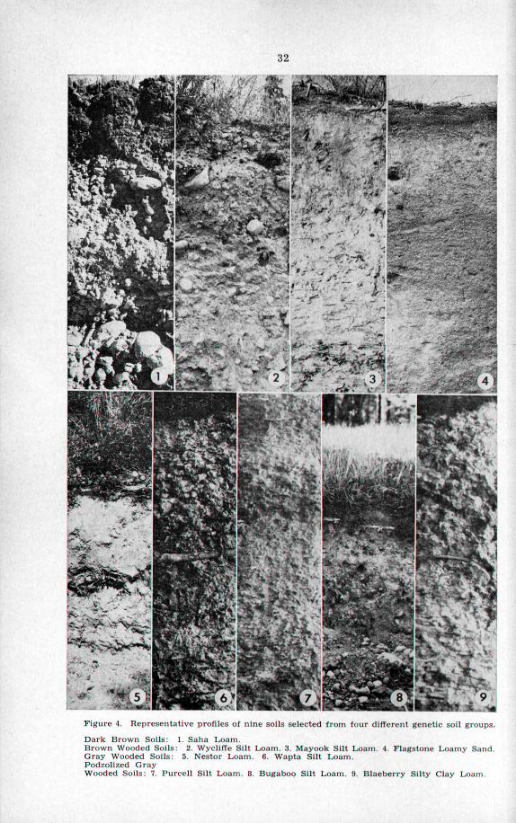
Figure 4. Representatlve profiles of nme SOI~S selected from four dlfferent genetic sol1 groups
Dârk Brown Soils: 1. Saha Loam. Brown Wooded Soils: 2. WyclilTe Silt Loam. 3. Mayook Silt Loam. 4. Flagstone Loamy Sand Gray Wooded Soils: 5. Nestor Loam. 6. Wapta Silt Loarn. Podzolized Gray Wooded Soils: 7. Purcell Silt Loam. 8. Bugaboo Silt Loam. 9. Blaeberry Silty Clay Loam

33
Poorly drained, depressional areas occur in a11 of the described soi1 groups. With poor drainage, soi1 aeration is limited, chemical reduction processes become important and the subsoils are grayish, with strong brown to bluish mottles. Restricted aeration also causes organic matter accumulation at the surface. When organic matter is more than 36 inches deep, the soi1 is classed as Deep Peat.
Another group of soils in the Upper Columbia River valley occurs on flood- plains and fans where deposition is still taking place. These soils have no characters other than those inherited from the alluvium of which they are com- posed, and are classified as Regosolic soils.
In this report the various soi1 types are arranged in Genetic Soi1 Groups after descriptions of the general characters of each of the soi1 groups are given.
In Figure 4 a representative profile is shown for each of nine soils selected from four genetic soi1 groups of the mapped area.
Soi1 Classification
A soi1 survey identifies, maps and describes the different kinds of soils in a given area. Field classification begins at the level of the soi1 “series”. In a soi1 series are soils derived from one kind of parent material and occupying one drainage position. Generally, the soils of a series have typical topography, horizons and other characters in comparison with other soils. When possible a series is given a name from a locality where it is found. It becomes known by its name and by its description in the soi1 survey report.
In this report, where two or more series were not separated on the soi1 map, the profiles and other characters of each are described separately. Soi1 series are divided into types on the basis of the texture of the A horizon, or that of the layer to plow depth if the soi1 is cultivated. Texture class names, such as sandy loam or silt loam, are added to a series names to give a complete name of a soi1 type, an example being Wycliffe Silt Loam. Subdivisions of soi1 types important to agriculture are called phases. Phases are based on such characters as ‘topography’, ‘grave1 or ‘stoniness’, and are indicated on the soi1 map by appropriate symbols.
A soi1 may be excessively drained, well drained, or poorly drained, depending on its topographical position and the texture of the whole profile. Those soils derived from gravelly and sandy deposits, in terrace positions, have excessive drainage. Fine-textured soils on slopes or terraces that are free from the influence of ground water are well-drained soils. Poorly drained soils are those affected by ground water.
A soi1 “complex” consists of a group of undifferentiated soils with at least one distinguishing feature m common. The common feature of the Wigwam Soi! Complex is that the inclu&d soils have developed on a widely distributed system of alluvial fans. Apart from this relationship Wigwam soils have various parent materials that occur under several conditions of climate and drainage. This complex cari be separated into a number of soi1 series, textural classes and phases. However, such differentiation was not warranted during the pioneer soi1 survey.
The probable origin of the soil-forming deposits is outlined in the section “Geology of Soi1 Parent Materials.” In this report the soi1 series have been arranged in genetic soi1 groups. The relationship of the soil-forming deposits to the soi1 groups and series is shown in Table 4.
90489-O-3

Table 4.-Classification of Soils in the Upper Columbia River Valley
GLACIAL PARENT MATERIALS Strongly to weskly calcareous
Glacial till..
Glacial outwash over till..
Gravelly glacial river deposits..
Sandy glaciofluvial deposits.. . .
Silt and clay river and lake deposits.. . . . .
POSTGLACIAL PARENT MATERIALS Strongly to weakly calcareous
Alluvial fans. . ..<....,.<....__.......<...,.,,,,
Floodplains and second bottoms.. , .
Organic deposits.. . .
ZZZ
- -
.
-
Dark Brown soils
Saha
..<.<..<...,<.,
. . . . . ...<.....
. . .
Wycliffe
Elko Misko
Flagstone
Mayook
Nokie Lakit Wigwam
..<.<.<.......
Kinbasket Cedrus
. . . . . ...<
..<<<.........
Brisco
Wapta
N;,dt’,“,” Wigwam
..<........
Podzolired Gray Wooded soils
Yoho
Bugaboo Dogtooth
Narboe
Wonah Palliser
Purcell Blaeberry
Golden Wigwam
Ref;;lic
McMurdo
Hamber Nowitka
Deep Peat

35
DESCRIPTIONS OF SOILS 1. Dark Brown Soils
Saha Loam is the one calcareous, Dark Brown, natural grassland soi1 type in the Upper Columbia River valley. A member of this series was first named in the Upper Kootenay River valley, where it is commonly found between Skookumchuck Prairie and the 49th parallel.
A few miles north of Invermere and on the east side of the valley, several areas of undifferentiated Elko-Saha soils occur; these are areas of trees and grass, and are an intimate mixture of the two soi1 types. The Dark Brown soi1 underlies the area of grassland vegetation, and the Elko Loam, a Brown Wooded soi1 type, is the soi1 under the needle-mat in groves of trees and under scattered trees. The areas of Elko-Saha soils between Invermere and Edgewater are the most northerly extension of Dark Brown soils in the classified part of the Rocky Mountain Trench.
Figure 5. Elko-Saha mils and the Purcell Mountains.
Description SAHA LOAM
The Saha series is a group of gravelly soils that have developed under grass on relatively flat-bottomed channels formed by glacial rivers, and on terraces. The channels were excavated in the till-plain by streams of melt-water from retreating glacier ice. The terraces line the present channels of down-cutting streams. The largest areas occur near Invermere and Windermere. The topog- raphy varies from gently undulating to gently sloping, and ,a few areas are pocked with kettles. The elevations range from 2,800 to 2,850 feet above sea level.
In the Upper Columbia River valley the ‘Saha soils were mapped together with those of the Elko series as Elko-Saha soils, since the intimate association of scattered trees and grass only partly distinguishes the two soi1 types from each other. In the Elko-Saha group the Saha soils have the same profile as the Saha Loam described in this section. About 1,380 acres .of the Elko-Saha soils were mapped, of which 593 acres are sloping to undulating and 787 acres are a kettled phase.
96489-O-34

..- .--. . .._... -- -.-.-.-- -..--. .- _ .-.- - .-.-..-- . .._ -.
The Saha and Elko soils have developed from the same parent material, which is a comparatively thin, fine-textured layer over thick water-sorted grave1 that is open and porous. The Saha type is distinguished from a11 others as, a thin, Dark Brown soi1 that has a layer of lime cementation in horizon B-D,., and in which there is an intermixing of the fme-textured Upper stratum with the gravelley lower one. The texture ranges from fine sandy loam to silt loam, loam being the average for the type. The acreages of fine sandy loam and silt loam are not significant. Under natural conditions the Saha soils are excessively drained.
The Saha Loam supports a climax growth of bunch grasses that may be easily overgrazed. In most areas these grasses have been replaced by spear grass, oth& secondary grasses and weeds. The second growth is scanty and the pasture of poor quality.
The following is a description of a Saha soi1 profile, taken about half a mile north of the Shuswap Indian village, and 400 yards west of the main highway. The site is virgin with scattered juniper and Douglas fir, but it is overgrazed. It is gently sloping and excessively drained.
Horizon Depth Description AI o- 5” Dark grayish Brown (dry), or very dark brown
(moist) loam. Coarse, breaking to medium granular structure; soft, friable, scattered gravel. Many tic roots. pH 7.7.
BI 5- 8” Brown (dry), dark grayish-brown (moist) loam. Fine to medium subangular blocky structure; soft, slightly compact, scattered gravel, calcareous. Root mats in the lower part. pH 7.9.
B-Dca 8-11” Light gray (dry) to yellowish-brown (moist) gritty loam mixed with lime-coated stones and gravel. Fine subangular blocky structure between stones, lime-cemented. Scattered roots. pH 8.2.
D 11” + Roughly stratified mixture of Sand, grave1 and stones to considerable depth. Porous, lime-coated stones in Upper part. pH 8.5. ,
Agriculture In its natural state this type is suitable only for range, which is particularly
poor where bunch grass has been destroyed and is replaced by annual grasses and weeds. Under irrigation the Saha soils should be used only for sod crops that require minimum cultivation. Because of the high porosity of the gravelly ‘substratum beneath the lime layer, irrigation water must be flumed or piped to the land.
The topsoil has more nitrogen and organic matter than other soils of the region but maintenance of these constituents under cultivation would be neces- sary because of the thin solum. These soils are deficient in phosphorus and boron. The partly permeable layer of lime-cetiented grave1 is from 11 to 18 inches below the surface. This hardpan checks the downward movement of irrigation water and may cause the soi1 above to become saturated by exces- sive irrigation. TO irrigate such soils properly, light but frequent sprinkler applications are required. Irrigation should begin in May with a total require- ment of four acre-feet of water for the season. Domestic water is not obtain- able from Wells, and would have to be stored in concrete cisterns to supply farm requirements.
There was no cultivated land of the Saha type in the area at the time of classification. Such land shquld be subdivided SO that part of the acreage of a farm would include another soi1 type that has a greater range of capability. Saha soils are of limited use and are best suited for hay and irrigated pasture.

37
In the classification of the Elko-Saha soils according to their suitabilitv for irrigation, the undifferentiated areas were divided ii-&: 330 acres of third- class, 263 of fourth-class, ‘715 of kettle-phased third-class, and 72 of kettle- phased fourth-class land.
2. Brown Wooded Soils
Soils of the area between Edgewater and Canal Flats have strongly cal- careous parent materials; the area has light snowfall in winter and dry periods in summer. In the central part of this region the Brown Wooded soils are associated with small areas of Dark Brown soils. The soi1 development is almost regosolic, particularly in the silty and sandy soi1 types. Between Edgewater and Brisco the Brown Wooded soils have maximum development where they grade into Gray Wooded soils. ,
In this smaI1 area of calcareous soils the range of Brown Wooded soil development is from minimal to maximal. The development is about as follows:
Horizon Ao
Al
A
AB-1
AB-2
Desctiptim A thin layer of forest litter from one half to one inch thick. Light brownish gray, from one half inch to two inches thick, usually absent. Pale brown to dark grayish brown. A weakly developed platy horizon from one inch to two inches thick. Pale brown, weak subangular blocky structure, four to eight inches thick. Light yellowish brown, weak subangular blocky structure, two to four inches thick; car-mot always be separated from horizon above.
The average depth of the AB-2 horizon, from which free lime has been removed, is 10 to 12 inches. The pH of the soi1 from the A1 to the AB-2 horizon is from 6.6 to 7.9. In the limy horizon below, designated Cca, the -pH ranges from 8.0. to 9.0. The carbonates of calcium and magnesium are the chief constituents that move downward in the profile. There is little evidence that colloidal clay and the’ oxides of iron and aluminum move downward in these soils as they do in Gray Wooded soils.
The Brown Wooded soils were mapped as seven series named Wycliffe Loam, Elko Loam, Misko Loam, Mayook Silt Loam, Flagstone Loamy Sand, Nokie Silt Loam and Lakit Sandy Loam.
Description WYCLIFFE SILT LOAM
The Wycliffe series includes silt loam, a Brown Wooded soi1 type derived from calcareous glacial till. It occurs mainly on the west side of the vdley between Canal Flats and Forster Creek. There are also a few areas on the east side of Lake Windermere to near Edgewater. North of Forster Creek the Wycliffe soils gradé into the Kinbasket series of Gray Wooded soils.
The Wycliffe series has till-plain topography, featured by a general slope to- ward the valley center. The original till-plain has been separated by subsequent channels of tributary streams into several areas of unequal size. The surface is drnmlinized and morainic. Drumlinized areas vary from ronnded, narrow hills with steep north and long south slopes to rounded hills with moderate slopes in a11 directions.. The morainic areas have moderateIy to strongly rolhng relief. The lowest elevation, 2,750 feet, is southwest of Lake Windermere; the highest elevation, 3,600 feet, in between Toby and Horsethief creeks. Of the total 48,102 acres, 26,434 are rough broken land and 21,688 potentially irrigable land.

38
Under a solum of 14 to 18 inches the grayish-white parent material ranges from gritty loam to silt loam. The coarser grades of sand are rare, indicating that this is a till abraded from fine-textured, sedimentary rocks. The fine- textured bulk material contains variable amounts of rounded gravels, stones and boulders. The till is calcareous, hard when dry and, on exposure, soft when wet. The till is thickest on the west side of the valley. It is thinner towards the east side, and there is underlain by stratified sands and gravels.
Figure 6. Irrigated Wycliffe silt loam.
The Wycliffe soi1 type is silt loam in average texture, but loam and occa- sionally very fine sandy loam are included. Silt and very fine sand were added to the surface by wind action in the past. The àmount of loess deposited varies from a thin, scarcely observable mantle to a layer of a foot or more.
In natural conditions the Wycliffe soils are well drained, but restricted interna1 drainage probably would occur with the application of irrigation water. This might not affect the Upper soi1 horizons but there might be saturation in the horizon just above the impervious till. Saturation in the lower part of the profile would be relieved by downslope seepage, but this would result in development of seepage areas at the toe of the slope. However, good irrigation practice would reduce the amounts of saturation and seepage.
The native vegetation is light to medium stands of mixed mature and second-growth Douglas fir, lodgepole pine, juniper, and aspen in the hollows. There is a scanty ground caver of soopolallie, rose, kinnikinnick, saskatoon and pine grass and other grasses. Most of the mature trees have been logged, leav- ing strumps from 20 to 50 feet apart.
A profile taken from the west side of Lake Windermere, 4.6 miles south of the Invermere post office, is ,described. The site has a gentle south slope, with undulations caused by uprooted trees. The profile is described as follows:
Horizon Depth Description Ao l- 0” Forest litter, fluffy, well decomposed in the lower
part. pH 5.7. A o-1 4” Light brownish gray (dry), dark grayish-brown
(moist) silt loam. Thin platy structure; loose, porous, scattered gravel, stones and boulders. Many fine roots. pH 6.7.

Horizon Depth Description AB 1,1-10” Light yellowish-brown (dry), dark yellowish-
brown (mois0 silt loam. Weak subangular blocky structure; slightly compact, scattered gravels, stones and boulders. Many fine roots. pH 6.6.
Cca 10-14” Pale yellow (dry), light olive (moist) silt loam. Weak medium subangular blocky structure; scattered lime-coated gravels, stones and boulders. pH 8.0.
Cl 14-22” Light gray (dry), pale Brown (moist) gritty silt loam. Massive, breaking to subangular clods, com- pact, stony, calcareous. pH 8.5.
CZ 22” + Light gray (dry), pale brown (moist), gritty silt loam, calcareous glacial till. Stony, hard, cemented, impervious. pH 8.9.
Agriculture
39
Wycliffe soils in the virgin state produce forest products, including Christmas trees for export, and some grass range for cattle. The high lime content of these soils aggravates the summer drought in natural conditions. Growth of vegetation is slow and stunted and the range has low carrying capacity. Where the topography is favorable and stones are not too numerous, these soils are suitable for irrigated mixed farming. Before irrigation and cultivation cari be ïnitiated, forest growth must be cleared and surface stones and boulders removed. Stones may have to be removed periodically.
After the soils are prepared for agriculture, and if they are well managed, their fertility should increase. Under good management they should make efficient use of irrigation water. The farm water requirement is about 30 acre- inches for an irrigation season from May 15 to September 15 and light applica- tions are recommended. The fairly rough topography requires use of sprinklers in irrigation to lessen soi1 erosion and to control the amount of water applied. Excessive irrigation, because of the impervious substratum, would saturate the Iower part of the soi1 profile and cause seepage to Iower areas.
With rare exceptions well water cannot be obtained under the Wycliffe soils because of the well-drained topography and the imperviousness and thick- ness of the till. Cisterns would be necessary to store domestic water when the irrigation system is not in use. At places where the till is thick and compact, water loss from seepage is low, and thus unlined cisterns for stock. use are possible. Water for stock cari also be stored by ponding natural depressions underlain by till.
A few small areas of Wycliffe soils have been reclaimed and irrigated. The crops produced are chiefly alfalfa, wheat, oats, and hay, which give good yields. Usually a few stones have to be removed at the time of each cultivation. The development of the main areas of these soils Will require large irrigation projects having water sources in the main tributary streams. Since water storage sites are lacking, only limited use cari be made of the smaller streams.
In the classification of soils according to suitability for irrigation there are about 2,287 acres of second-class, 18,920 of third-class, and 461 of fourth- class land. Rough, broken land; unsuitable for irrigation, amounts to 26,434 acres.
Description ELKO LOAM
The Elko series is a group of shallow, gravelly soils that developed on gravelly, glacial river channels and on gravelly terraces. The channels were eroded through the till-plain by streams from melting glacier ice and were abandoned thereafter. The terraces are chiefly in the valleys of down-cutting
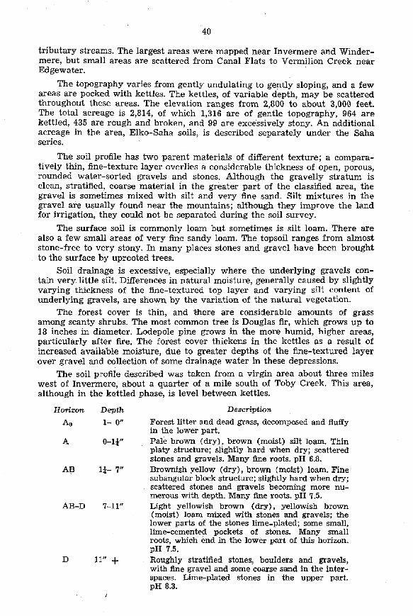
. .- -- _.-.--- ..- -. .- . ---- --- ---- ------- --- - ,
tributary streams. The largest areas were mapped near Invermere and Winder- mere, but small areas are scattered from Canal Flats to Vermilion Creek near Edgewater.
The topography varies from gently undulating to gently sloping, and a few areas are pocked with kettles. The kettles, of variable depth, may be scattered throughout these areas. The elevation ranges from 2,800 to about 3,000 feet. The total acreage is 2,814, of which 1,316 are of gentle topography, 964 are kettled, 435 are rough and broken, and 99 are excessively stony. An additional acreage in the area, Elko-Saha soils, is described separately under the Saha series.
The soi1 profile has two parent materials of different texture; a compara- tively thin, fine-texture layer overlies a considerable thickness of open, porous, rounded water-sorted gravels and stones. Although the gravelly stratum is clean, stratified, coarse material in the greater part of the classified area, the grave1 is sometimes mixed with silt and very fine Sand. Silt mixtures in the grave1 are usually found near the mountains; although they improve the land for irrigation, they could not be separated during the soi1 survey.
The surface soi1 is commonly loam but sometimes is silt loam. There are also a few small areas of very fine sandy loam. The topsoil ranges from almost stone-free to very stony. In many places stones and grave1 have been brought to the surface by uprooted trees.
I
Soi1 drainage is excessive, especially where the underlying gravels con- tain very little silt. Differences in natural moisture, generally caused by slightly varying thickness of the fine-textured top layer and varying silt content of underlying gravels, are shown by the variation of the natural vegetation.
The forest caver is thin, and there are considerable amounts of grass among scanty shrubs. The most common tree is Douglas fir, which grows up to 18 inches in diameter. Lodepole pine grows in the more humid, higher areas, particularly after fire. The forest caver thickens in the kettles as a result of increased available moisture, due to greater depths of the fine-textured layer over grave1 and collection of some drainage water in these depressions.
The soi1 profile described was taken from a virgin area about three miles west of Invermere, about a quarter of a mile south of Toby Creek. This area, although in the kettled phase, is level between kettles.
Horizon Depth Description
Ao l- 0” Forest litter and dead grass, decomposed and fluffy in the lower part.
A O-l 3” Pale brown (dry), brown (moist) silt loam. Thin platy structure; slîghtly hard when dry; scattered stones and gravels. Many fine roots. pH 6.8.
A!? l& 7” Brownish yellow (dry), brown (moi&) loam. Fine subangular block structure; slightly hard when dry; scattered stones and gravels becoming more nu- merous with depth. Many fine roots. pH 7.5.
AB-D 7-l 1” Light yellowish brown (dry), yellow.ish brown (moist) loam mixed with stones and gravels; the lower parts of the stones lime-plated; some small, lime-cemented pockets of stones. Many small roots, which end in the lower part of this horizon. pH 7.5.
D 11” + Roughly stratified stones, boulders and grave& with fine grave1 and some coarse sand in the inter- spaces. Lime-plated stones in the upper part. pH 8.3.
I

41
Agriculture Without irrigation the Elko soils are suitable only for forest and forest
range. Under irrigation they should be used only for sod crops that require minimum cultivation. Tilled crops such as potatoes and root vegetables should not be grown. Irrigation water must be flumed or piped to the land, because of the high porosity of the gravelly substratum.
The type of agriculture under irrigation should be dairying and beef production, and the land subdivided SO that part of a farm acreage is of another soi1 type. TO water the land properly there should be sprinkler irriga- tion in frequent, light applications. The first irrigation is needed in May in a dry spring, and for the season the farm water requirement Will be about 44 acre-inches. Domestic water cannot be got from Wells to supply farm require- ments, and it would have to .be stored in concrete cisterns.
Land clearing for cultivation includes removal of the light forest and the stones. TO remove stones is the greater job. The shallow-rooted trees and the stones coula be handled in part by land-clearing machines. The most feasible method of development is to settle the least stony soils first, and to gradually develop stonier areas as the land value increases.
Only a few small areas of Elko soils were cultivated at the time of the survey (1954). These areas were inadequately irrigated and did not produce well. In the classification of soils according to suitability for irrigation, 1,316 acres of Elko soils of gentle topography were grouped as follows: 426 third-class, 569 fourth-class, and 321 fifth-class. Of 964 acres of the kettled phase, 146 are thir’d-class, 540 fourth-class, and 278 fifth-class land. The rough broken phase amounts to 435 acres and there are 99 acres of excessively stony land. The two last-named groups are nonirrigable.
MISKO LOAM Description -
Soils of the Misko series are derived from gravelly, glacial river terraces and channels. They occur mainly on terraces along Frances Creek and the Spillimacheen River, and on a few flat bottomed, gravelly channels near entry points of streams tributary to Frances Creek.
The topography is gently sloping to gently undulating with a range in elevation from 3,160 to 3,600 feet. Of a total of 3,798 acres only 941 are suitable .for agriculture. The remander, 2,857 acres, is excessively stony.
The soi1 profile has two parent materials of different texture, similar in composition to those of the Elko and Saha series. A comparatively thin, fine- textured layer overlies a considerable thickness of rounded, water-sorted grave1 and stones that is open and porous. The soi1 is mainly loam, but to a minor extent it is silt loam and sandy loam. The amounts of stones and boulders in the sur-face soi1 vary widely. Stones, are most abundant where they have been heaved to the surface by the roots of falling trees.
Like the Elko series, these soils are excessively drained. The Misko Loam is more extensively developed than the Elko Loam, because it is in a locality of higher rainfall. The Misko Loam has maximal Brown Wooded, soi1 develop- ment compared with the media1 soil development of Elko Loam.
The forest caver is a dense stand of lodgepole pine, with scattered Douglas fir, aspen and willow. Where burns are recent, the stand is fairly open and scrubby. The ground caver is mairily pine grass with lesser amounts of kinni- kinnick, soopolallie, strawberry and other plants.
A profile was examined just east of %rances Creek, about three miles north of Forster-Frances Creek junction and is described as follows:
96489-O-4
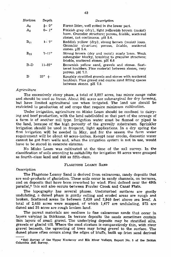
42
Horizon Depth Desctiption
Ao B- 0” Forest litter, well rotted in the lower part. A2 o- 1” Pinkish gray (dry), light yellowish brown (moist)
loam. Granular structure; porous, friable, scattered stones, not continuous. pH 5.4.
61 l- 7” Reddish yellow (dry), strong brown (mois0 loam. Granular structure; porous, friable, scattered stones. pH 5.4.
B12 7-11” Strong brown (dry and moist) sandy loam. Weak subangular blocky, breaking to granular structure; friable, scattered stones. pH 6.6
B-D 1 l-22” Brownish yellow Sand, gravels and stones. Scat- tered boulders. Fine material between stones, very porous. pH 7.7.
D 22” + Roughly stratified gravels and stones with scattered boulders. Fine grave1 and coarse Sand filling spaces between stones. pH 7.9.
The excessively stony phase, a total of 2,857 acres, has minor range value and should be used as forest. About 941 acres are submarginal for dry farming, but have limited agricultural use when irrigated. The land use should be restricted to production of sod crops that require minimum cultivation.
Under irrigation, agriculture on Misko Loam should be confined to dairy- ing and beef production, with the land subdivided SO that part of the acreage of a farm is of another soi1 type. Irrigation water must be flumed or piped to the land, because of the high porosity of the gravelly substratum. Sprinkler irrigation should be used in frequent, light applications. In a dry spring the first irrigation Will be needed in May, and for the season the farm water requirement Will be about 40 acres-inches. Except near creeks, domestic water cannot be got from Wells and, when the irrigation system is not in use, would have to be stored in concrete cisterns.
No Misko Loam was cultivated at the time of the soi1 survey. In the classification of soils according to suitability for irrigation 95 acres were grouped as fourth-class land and 846 as fifth-class.
Description FLAGSTONE LOAMY SAND
The Flagstone Loamy Sand is derived from calcareous, sandy deposits that are end-products of glaciation. These soils occur in sandy channels, on terraces, and on deposits that have been reworked by wind. First defined near the 49th parallel,s this soi1 also occurs lbetween Forster Creek and Canal Flats.
The topography has several phases. UndiSturbed. surfaces are gently undulating, a duned phase is gently rolling and eroded areas are rough and broken. Scattered areas lie between 2,630 and 2,940 feet above sea level. A total of 2,485 acres were mapped, of which 1,477 are undulating, 973 are duned and 35 acres are rough broken land.
The parent materials are medium to fine calcareous sands that occur in layers varying in thickness. In terrace deposits the sands sometimes contain thin layers of small gravel. The underlying deposits may be stratified sfits, gravels or glacial till. Where the sand stratum is comparatively thin, with river grave1 beneath, the uprooting of trees may bring grave1 to the surface. The duned phase often occurs along the edges of bluffs, built up from sand derivd
BSoil Survey of the Upper Kootenay and Elk River Valleys. Report No. 5 of the Britiah Columbia Soi1 Survey.

43
from the faces of the bluffs. These duned areas are a quarter of a mile or more wide. In the duned phase the sand is of uniform texture and often of con- siderable thickness.
Figure 1. Flagstone loamy Sand, duned phase.
The soi1 is weakly developed. It is calcareous, medium- to fine-textured loamy Sand, and is classed as a regosolic intergrade of the Brown Wooded soil group. The surface and interna1 drainage are good, the soi1 being droughty under natural conditions and well-drained when irrigated.
The native vegetation is an open forest of Douglas fir, lodgepole pine, and juniper, with ponderosa pine as far north as Dutch Creek. The main shrubs are saskatoon, rose and waxberry, and there is a thin ground caver of pine grass, other grasses and weeds. A profile about one mile south of Windermere in moderately duned topography was described as follows:
Horizon
Al
AH
Cca
C
Depth o- 2”
2- 4”
4-18”
18” +
Desctiptin Light brownish-grey to pale brown (dry), dark grayish-brown to dark brown (moist) light sandy loam. Weak crurnb breaking to single-grained structure. Soft, friable. pH 7.6. Brown (dry) brown to dark brown (moi&) light sandy loam to loamy sand of fine to medium tex- ture. Weak subangular blocky structure easily breaking to single grains. Friable, porous. pH 7.9. Light yellowish brown (dry), brownish-yellow (moist) fine sandy loam to loamy Sand. Very weak subangular blocky structure easily becoming single-graine& Friable, porous, calcareous. pH 8.0. Light gray to pale yellow (dry), pale yellow (moist) fine to medium Sand. Massive, friable, loose, porous in dunes. Stratified on terraces. No stones or gravel. Calcareous. pH 8.1.
96489-O-44

:
44
Agriculture The Flagstone Loamy Sand is used for ranging stock and for production
of timber and Christmas trees. If irrigated, it could produce crops suitable to the climate.
This is the warmest, earliest, and the most easily cultivated soi1 in the classified area. It erodes easily and cultural and irrigation practices should be designed to lirnit erosion. The main irrigation ditches should be flumed or piped to prevent seepage losses. Sprinkler irrigation is recommended at the rate of about 40 acre-inches per season. There is little or no possibility of having well water. Water storage in lined cisterns Will be required for domestic and stock us&
Land clearing reqires..remov&of a thinforest of shallow rooted trees, old logs and stumps. The work of clearingis comparatively light, and machinery could be used to advantage. Some stone removal may be necessary along soi1 boundaries where the Flagstone-series.meets stony soils. .-...,
A small acreage of Flagstone Loamy Sand near Invermere is”‘<ivated and irrigated and produces satisfactory crops of alfalfa and vegetables. Also, some hardy tree fruits are grown but these show much damage from the climate. In the classification of soils according to suitability for irrigation, the terrace and charme1 phase has 972 acres of second-class and 505 acres of undulating third-class land. The duned phase contains 629 acres of second- class and 344 of third-class land. In addition, 35 acres are rough, broken and unsuitable for irrigation.
.
Description MAYOOK SILT LOAM
The Mayook soils in the mapped area are derived from glacio-lacustrine silts that are strongly calcareous. The stratified silts occur continuously on both sides of the Columbia River channel from near Canal Flats to Spillimacheen. The northern limit of the Brown Wooded Mayook soils is South Vermillion (Kindersley) Creek. North of there the Gray Wooded Brisco soils are derived from the lacustrine silts.
The silts were at first a thick valley-bottom deposit pocked in places by kettles. Subsequently, a river channelled the Center to 75 feet deep or more, leaving vertical bluffs on each side. The yearly freshet has gullied the bluffs to a ragged fringe, and in places these gullies head back half a mile or more. In some places gullies have merged near their heads, leaving small mesalike areas with channels around them.
The soils occur at 2,600 to 2,840 feet above sea level. The lowest occurrence is near Edgewater, where the silts are at the level of the Columbia River. The silt deposit has been eroded to this depth but no underlying deposit is exposed. The highest occurrence seems to be a shoreline, since the constant Upper limit of the silts is at this elevation. In a total of 12,312 acres mapped, 5,000 are gently sloping to gently undulating, and 954 are rolling’ and mesalike. There are 279 acres of kettled areas that could be used for agriculture and 6,079 acres of the eroded, rough, and broken phases.
The parent material is well-bedded, whitish, stratified silts, chiefly of silt loam texture. In some. places the silt percentage is very higli. The silts are strongly.calcareous and,are from a few feet to several hundred feet deep. The soi1 also is mainly silt loam, but small areas of very fine sandy loam occur that have not be differentiated. The lighter textures of some areas are caused by slight variations in the parent material and sometimes by a surface capping of loess from one to several inches thick. The Mayook soils are well drained under natural conditions.

_ .__.. -.-. .-.- ------
45
The native vegetation, which is of light to medium density, is mainly scrubby Douglas fir of mixed ages, and scattered juniper. A thin stand of lodge- pole pine succeeds on burns. The areas of kettles and coulees support thick stands of aspen and some spruce. The sparse ground caver includes snow- berry, rose, kinnikinnick, and pine grass. Rabbit bush and pasture wormwood are found on bluff exposures. Distichlis and lime grass grow on eroded slopes.
Figure 8. Mayook silt loam bordering Columbia Lake.
A profile was examined at the west side of the valley, about three miles north of Dutch Creek. The area from which the profile was taken was level, and had an elevation of about 2,800 feet. The virgin location had a parklike stand of Douglas fir and thin grass caver. The profile description is as follows:
Horizon Depth. Description
Ao $- 0” Decaying forest litter. White fungi on twigs in the lower part. pH 5.8.
A1 o- $1’ Light brownish gray (dry) silt loam mixed with organic material, weakly platy, fluffy. pH 6.6.
A 3-22” Pale brown (dry> silt loam. Pltity, friable, porous. pH 6.4.
AB-1 2% 8” Very pale brown (dry) silt loam. Weak subangular blocky breaking to crumb structure; friable, firm when dry. pH 6.9.
AB-2 8-10” Light yellowish brown (dry) < loam. Weak sub- tigular blocky breaking to granular structure. Root mats in the lower part. Slightly calcareous. pH 7.9.
C EL 10-20” Pale yelloti (dry) silt loam. Compact, breaking into small nodular forms. Strongly calcareous. pH 9.2.
C 20” + White (dry) stratified silt loam. Dense, compact, breaking into plates; no stones or gravel. Strongly calcareous in the Upper part. pH 9.5.

46
Agriculture In a natural state, the Mayook soils are used for limited grazing and
Christmas tree production. When irrigated, this soi1 could produce any trop that is climatically suited, including legumes, grasses, potatoes, cool-season vegetables, and some small fruits.
The cultural and irrigation practices should be designed to minimize erosion. These soils erode easily, and water saturation of the silts along exposed bluffs causes collapse of the banks. Exposure of the alkaline Cca and C horizons, caused by levelling or erosion, Will inhibit the growth of crops.
The farm water requirement is about 30 acre-inches between May 15 and September 15, and earlier or later applications are sometimes desirable. Sprink- ler irrigation is recommended in light and frequent applications. There is little or no possibility of obtaining well water due to the topographie position of this soil. Cisterns Will be necessary to store domestic water and water for stock. The medium-open forest cari be cleared with machinery.
Some small scattered areas of Mayook soils are cultivated and irrigated and produce good crops of alfalfa, hay, grain, and potatoes. The levelling done in these areas left bare spots in the fields, which may be reclaimed by covering them with topsoil.
In the classification of soils according to suitability for irrigation, there are 5,000 acres of second-class, 873 of third-class, and 81 of fourth-class land. There are also 279 acres of kettled, thifd-class land. In addition, 6,079 acres of rough, broken land are unsuitable for irrigation.
NOKIE SERIES The Nokie series is a group of Brown Wooded soils derived from complete
fans and the remaining sections of compound fans above the present level of drainage. Limited areas of the series occur on both sides of the valley, from one mile north of Canal Flats to near Luxor.
In complete fans the topography is that of a gently sloping fan apron, with a main downward slope and lateral slopes to right and left. In some areas, old stream braids have left places depressed about a foot below the general surface. In others, there are gentle undulations and some kettles. The areas may be small of soils that occur on the Upper part of a compound fan and they may be bordered on one side by a deeply tut stream channel. The Nokie soils occur at 2,595 to 3,000 feet above sea level, and their area totals 8,393 acres.
The parent material is chiefly calcareous silt and very fine sand overlying stratified coarser Sand, grave1 and stony material. A fan was built by deposits from successive outwash waters. New channels were eroded and new deposits buried old ones that contained coarse material. The coarse material, beneath the top layer of silt or very fine Sand, was deposited from tiater of tee old runoff channel. Since the Nokie soils are derived from fan material, they are regarded as a differentiated part of the Wigwam Soi1 Complex.
The surface soils are mainly silt loam and very fine sandy loam, and occasionally loam. The top layer of fine sediment, from 14 inches to four feet or more deep, overlies a coarse substratum. This is usually from a few inches to several feet thick and is in turn underlain by silt or very fine sand sorted from earlier outwashes. Under natural conditions the Nokie soils may be excessively drained to wel! drained on the Upper parts of fans, but water tables occur at three feet or more deep on the lower sections of some fans.
The native vegetative caver varies from a parklike distribution of trees to medium forest of Douglas fir, lodgepole pine and aspen, with scattered junipe and others. The ground caver is mainly kinnikinnick, rose, snowberry, soop’ allie, strawberry, and pine grass.

47
Description NOKIE SILT LOAM
The silt loam type of the Nokie series occurs on both sides of the Columbia River channel and on separated fans along Columbia and Windermere lakes northward to Luxor. The largest areas are on the east side of the valley near Windermere and Wilmer, and at the mouth of Forster Creek. Nokie Silt Loam occurs between 2,700 and 3,000 feet elevation in scattered areas, and amounts to 7,538 acres. Drainage under natural conditions is good to excessive, depend- ing on the depth of coarse D horizon material.
A virgin soi1 profile, west of the Elkhorn Ranch on the main highway, at 3,000 feet elevation, is described as follows:
Horizon Ao
AI
Depth l- 0”
o- 2”
2- 6”
6-10”
10-33”
35” +
Description Forest litter, chiefly needles, twigs and grass. Fluffy, well decayed in the lower part. Very dark grayish brown (dry), black (moist) loam to very fine sandy loam. Weak platy struc- ture, flufIy. pH 7.2. Light yellowish brown (dry), dark brown (moist) silt loam. Very weak subangular blocky breaking to crumb structure, friable. pH 7.4. Pale yellow (dry), olive (moist) silt loam. Weakly blocky breaking to crumb structure, friable, porous. pH 7.7. Pale yellow (dry), yellowish brown (moist) silt loam in the upper part; pale yellow (dry), olive (moi&) siIt Ioam in the lower part. Weakly blocky breaking to crumb structure; porous, small and fim nodules around roots. Calcareous. pH 8.5. Stratified gravels, very calcareous, overlying silt.
AB-1
AB-2
CC.
D
7 Agriculture - 5 +Y
In the natural state, the Nokie Silt Loam is suitable for forest and has a minimum value as forest range. The trees and grass are stunted and the avail-
i. able range has low carrying capacity for livestock. This soi1 type should not ‘: bè cnltivated for dry farm cropping.
, If irrigated the Nokie Silt Loam is suitable for mixed and specialized farm- Lb in& The removal of a comparatively light stand of trees is necessary before .I tiojtivation and irrigation. Under furrow irrigation, the farm water requirement ‘$or the irrigation season is about 40 acre-inhhes, and the carrying capacity of
13 acre-inches for the peak month. With sprinkler irriga- requirement is 28 acre-niches, and the carrying capacity peak month is nine acre-inches. Sprinkler irrigation, with
management, would decrease the loss of water into the gravelly s ubsttatum. The excessive ‘use of water cari cause seepage that would result in s wamping around the margin of the fan apron.
-i Under natural conditions, well water may be obtainable near streams. The rf omainder of the fan area is usually dry with no groundwater available. After y< zars of irrigation, the substrata of silty fans may become saturated to levels tb ;.& may be reached by shallow Wells. Under these conditions limy well water C;G beeome available but in the meantime domestic water .would have to be st Iore$-;n cisterns.
-7Li’;c.; A ,e;w small areas of Nokie soils ,have been reclaimed and irrigated. The w4ter is, generally conducted from local creeks through open ditches ami aBlied $$y furrow irrigation. In one or two cases sprinkler irrigation is used. With an :,<;idequate water supply, the land is productive. ï

48
In the classification of soils according to suitability for irrigation there are 3,831 acres of second-class and 3,707 of third-class land.
Description NOKIE VERY FINE SANDY LOAM
Areas of very fine sandy loam are found on fans near the junctions of Dutch, Toby, Horsethief and Bugaboo creeks with the Columbia River. The type also occurs near the mouth of the Spillimacheen River. It occurs at 2,595 to 2,800 feet elevation. The area mapped amounts to 855 acres.
The soils are fine sandy loam and very fme sandy loam, the latter being more common. Though the very fine sandy loam is well drained to several feet deep, often there is a water table in the deeper strata high enough to support forest caver, but the density of growth varies widely.
The type has a weakly developed solum, chiefly because the uprooting of trees mixes parent materials in the A and AR horizons and occasionally brings grave1 and stones to the surface from horizon D. A profile on the Dutch Creek fan, 150 yards from the junction of the Invermere road and Highway No. 4, is described as follows:
Horizon
Ao A
AB d
Depth l- 0” o- 2”
2-12”
Desctipttin Dry needles, twigs and dead grass, .undecomposed. Light yellowish brown (dry), very fme sandy loam. Weakly platy breaking to single-grain structure, friable. pH 6.9. Pale yellow (dry), ver-y fine sandy loam. Weakly blocky breaking to crumbs and single grains; no stones or gravel. pH 7.3.
C 12” + Light gray (dry), very fine sandy loam. Strati- fied, slightly iron-stained; no stones or gravel. pH 8.0.
D Stratified river gravels underlying the Sand strata at various depths.
Agriculture The Nokie Very Fine Sandy Loam is suitable for forest and scanty range.
The forest growth ranges from fairly thick stands of trees to parklike conditions, and the cost of clearing land varies accordingly. Grass is more &ected by drought than the more deeply rooted trees, and the range value of this land for livestock is comparatively low. This soi1 type should not be cultivated for, dry farming. When reclaimed and irrigated the very fine sandy loam is suitabler for mixed and specialized farming. At the time of the soi1 survey there was nc? improved acreage. !
Irrigation water cari be conveyed to the land in open ditches but the ~O&S would be high and piping or fluming to points of distribution is more practica1. With furrow irrigation, the farm water requirement for this soi1 type is aber It 32 acre-inches per season. For sprinkler systems it is somewhat less. A domest:,@ water supply cari be obtained from comparatively shallow Wells because grounr’i- water is present at moder&e depths.
In the classification of soils according to suitability for irrigation, there : are 265 acres of second-class, 561 of third-class and 29 of fifth-class land.
Description LAKIT SANDY LOAM
This is a group of gravelly and stony soils derived from weakly ca ,lcarec@s and noncalcareous parent materials. It occurs in the valley of Dute,,h Cr&k for some distance upstream from its junction with the Columbia Ri$:: $xX. 1_

- JC-- 42 The topography is undulating to gently sloping toward the main valley
tenter. The soi1 occurs at 2,600 to 2,700 feet elevation, and the total area mapped is 488 acres.
The parent materials are Sand, grave1 and stones with a shallow overlay of fine material. The conditions of deposition were probably similar to those during the formation of ‘a fan by a fairly large permanent stream. Shifting and downcutting of the stream caused the gradua1 exposure of gravelly and stony areas. These were later coated with deposits of silts and sands during the annual freshets. F’inally, most of the area involved became too high above the level of runoff to receive further additions of sediment. Since soils of the Lakit series were derived from fanlike formations it has been regarded as a differentiated member of the Wigwam Soi1 Complex.
.Although the average texture is sandy loam, areas of loam occur. About six inches of surface soi1 overlie a coarse substratum, which gives excessive drainage. The gravelly and stony substratum varies in thickness and overlies older deposits. Since the Lakit soils generalIy have second bottom elevations, there is usually a water table present at different depths. A mixture of scat- tered trees and grass develops in areas where the water table is at the greatest depth,. and groves of trees or continuous forest are common in areas where the moisture supply is within the reach of tree roots.
A profile, taken from a site within a grove of trees, is described as follows:
Horizon Depth Description
Ao l- 0” Forest litter consisting of needles, twigs, grass, etc. AI O-l&” Brown (dry), very fine sandy loam. Weakly platy
breaking to weak crumb structure; porous, friable. Scattered surface gravel, stones and boulders. pH 6.4.
AB-D 1k-s” Grayish brown (dry) fine sandy loam. Weak sub- angular blocky breaking to single-grain structure in spaces between stones and gravel. Coarse and fine grave& and stones up to 8 inches in diameter. Porous and loose. pH 6.9.
D 6” + Light brownish gray mixture of river gravels, stones, boulders and sands. No lime plating on stones. pH 7.2.
AgricuEture In the native state the Lakit soils have limited-value as forest range or
forest. The surface soil overlying grave1 and stones is too thin for cultivation and the amount of irrigation water would be excessive for any agricultural purpose. The total area of 488 acres was classed as nonarable land.
3. Gray Wooded Soils
Gray Wooded soils occur in the Upper Columbia River valley between Edgewater and Donald. On the south this group of soils merges with the Brown Wooded soi1 group. TO the north, they mingle with the Podzolized Gray Wooded soil group.
Occurrence of Gray Wooded soils in the southern section indicates a simi- larity of parent materials to those of Brown Wooded soils, from which they cari develop in response to increased precipitation. Lime and clay in the parent material are necessary requirements for formation of the Gray Wooded profile.
TO the north, in spite of increased precipitation, the finer-textured and in some cases younger soi1 types keep their Gray Wooded status as though resistant to change, but the coarser-textured soi1 types associated with them have become podzolized.

-. .- - -,-. Where relatively mature Gray Wooded soi1 has developed, the essential
features of the profile are as follows: Horizon * Description
Ao Accumulated forest litter, from one to three inches thick according to vegetative caver.
A2 Very pale brown to light gray, platy structure; from two to five inches thick.
A3 Light yellowish brown transitional horizon from two to five inches thick, sometimes absent.
Bl Erownish yellow transitional horizon; compact, blocky structure; from two to five inches thick, sometimes absent.
B2 Yellowish brown, compact, blocky. The horizon of heaviest texture. From four to eight inches thick.
The wellldeveloped A2 and BP horizons are slightly acid. Transition hori- zons A3 and B1 are named from their associations with the horizon above or below. Colloidal clay and oxides of iron have moved downward and accumu- lated in the dense Bs horizon. Below this horizon is a calcareous horizon designated Bca, where the soi1 may be pH 8.0 or higher.
Six Gray Wooded Soils were classified and named as follows: Kinbasket Sih Loam, Cedrus Loam, Brisco Silty Clay Loam, Madias Silty Clay Loam, Nestor Loam and Wapta Silt Loam.
KINBASKET SILT LOAM Description
The Kinbasket series is a group of Gray Wooded soils closely associated with the Wycliffe series since they have similar parent materials. The -Kinbasket soils occur north of Forster Creek and west of Steamboat Mountain, and also on the east side of the valley from Edgewater to Spillimacheen. On their southern fringe they merge with the Wycliffe soils.
The topography is that of a till-plain, separated into unequal areas by sub- sequent water courses. The surface is drumlinized and morainic. The drum- linized areas vary from rounded, narrow hills with steep north and long southern slopes to rounded hills with moderate slopes in a11 directions. The morainic areas have moderate to strongly rolling relief. The soils occur at 2,850 to 3,600 feet above.sea level. In a total of 26,644 acres, 3,365 are suffi- ciently free of stones and level enough for farming. The remaining 23,279 acres are rough, stony and nonarable.
The calcareous parent till that underlies about 18 inches of weathered soi1 has a loamy and gritty texture and grayish-white color. The coarser grades of sand are present in very small amounts, indicating that the till was derived from fine-textured, sedimentary rocks. The loamy material is studded with gravels, of which the diameters usually are between one and three inches, although larger stones and boulders are scattered throughout the till mass. The till is hard when dry but on exposure it becomes soft when wet. On the west side ,of the valley the comparatively thick till often lies directly on bed- rock, whereas on the east side it is only three to six feet thick and the material beneath is stratified sands and gravels.
The soi1 is mainly silt loam, with occasional areas of loam. Wind action has added silt and very fine sand to the surface in the past. The loess deposit varies from a thin, scarcely observable mantle to a layer a foot deep or more.
The Kinbasket soils are well drained but restricted drainage would occur with the addition of irrigation water. This drainage restriction would appear in the dense B2 horizon and also in the horizon above the impervious under-

51
lying till. Saturation in the lower part of the profile would be relieved by down- slope seepage, which would corne to the surface at the toe of the slope and require drainage. However, good irrigation practice would largely prevent both saturation and seepage.
The native vegetation is medium heavy to heavy second-growth of Douglas fir, lodgepole pine, willow, and àspen. Some mature Douglas fir have survived logging, and have trunk diameters up to three feet. The ground caver contains pine grass, kinnikinnick, rose, soopolallie and scattered patches of moss. The area from which a profile was taken has an elevation of 3,000 feet and a gently undulating topography. The site is about 24 miles north of North Vermilion Creek and a third of a mile east of the main highway. This profile is described as follows:
Horizon
Ao
-%n
A22
J321
BO.
C
Agriculture
Depth
l- 0”
o- 4”
4- 8”
8-11”
11-14”
14-20”
20” +
Description
Forest litter. Decaying pine and fir needles, wood, grass, etc. Very pale brown (dry), pale brown (moist) silt loam. Platy breaking to granular structure. Firm, porous, scattered gravel. pH 7.1. Very pale brown (dry), yellowish-brown (moist) loam. Weak crumb structure; friable, a few soft concretions with iron-stained centers. Scattered grave1 and stones. pH 7.2. Brownish yellow (dry), yellowish brown (moist) clay loam. Subangular blocky, breaking to crumb structure; compact, soft concretions with iron- stained centers. Scattered grave1 and stones. pH 6.9. Yellowish brown (dry and moist) clay loam. Strong blocky structure; compact, the heaviest horizon; scattered gravels, stones, a few boulders. pH 7.4. Pale yellow (dry), light yellowish brown (moist) loam. Angular blocky structure with a few iron stains; compact, scattered gravel, stones and boulders. Root mat in the lower part. Calcareous. pH 7.9. Pale yellow (dry), olive (moist) loam and silt loam; glacial till. Dense, impervious, varying amounts of grave& stones and boulders. Calcare- ous. pH 7.9.
The Kinbasket soils,are used for forest production, including Christmas trees and forest range. The soils, where the topography is favorable and’stone not excessive, are suitable for irrigated mixed farming. Forest caver must be cleared and stones and boulders removed before cultivation and irrigation cari be undertaken. In most places the forest is fairly heavy and clearing by machinery would be desirable. Stones corne to the surface by frost action and Will need to be removed periodically.
The Kinbasket soils should make efficient use of irrigation water. The farm ,water requirement is about 22 acre-inches, light applications being recom- bended. The comparatively rough topography requires irrigation by sprinklers
-q,mit soi1 erosion. Because of an impervious substratum that restricts interna1 “sage, excessive amounts of water on these soils would cause seepage to
‘Ievels.

52
There is little chance in finding well water under Kinbasket soils. Cisterns Will be necessary for the storage of domestic water when the irrigation system is not in use. In places where the till is thidk and compact there is little loss by seepage and unlined cisterns for the storage of stock water are possible. Also, water for stock cari be stored in depressions.
None of this soi1 type was cleared or cultivated at the time of soi1 classifica- tion. Future development for agriculture Will require costly land clearing and substantial irrigation projects. In the classification of soils according to suitabil- ity for irrigation there are 3,267 acres of third-class and 98 of fourth-class land and 23,279 acres of nonirrigable land.
Description CEDRUS LOAM
The Cedrus series occurs in the Kootenay River valley upstream from Canal Flats,9 and in the Rocky Mountain Trench near Golden. The soi1 is derived from fine-textured, calcareous till eroded from ,beds of phyllite of the Paleozoic McKay Formation. Distinctive in color and texture, the phyllite is a feature of the till between Parson and Bluewater Creek. In the northern, more humid section, the Gray Wooded Cedrus series is succeeded by the Podzolized Gray Wooded Yoho series on the same parent material.
The topography is gently rolling to rolling ridges that run parallel to the main valley. Gently rolling areas occur northeast of Golden, the remainder of the classified area being rolling, with slopes up to 25 per cent. Occasionally the ridges are cross-tut by the gullies of tributary streams. The areas of Cedrus Loam are from 2,800 to 3,600 feet above sea level. In the total of 1,826 acres mapped, 1,295 are potentially arable and 531 are rough broken land.
The parent material is compact limy till of clay loam texture, with moder- ate amounts of stone and various amounts of phyllite. Its high phyllite content gives the till a distinctive whitish color. When the content of phyllite is low it often occurs in soft, stratified fragments, with whitish, weathered surfaces that fleck the till mass with white spots.
The soi1 is mainly loam, but a thin surface layer of silt loam is often present. This could be loess or a conversion of loam to silt loam by depletion of colloids, which moved down and accumulated in the Bz horizon. Stones and grave1 are scattered, but there are a few stony patches. On the slopes, the interna1 drainage is good in the Upper profile horizons but is slow in the lower ones as the underlying till is impervious.
The tree caver is a medium forest of second-growth Douglas fir, spruce, white pine, cedar, lodgepole pine, birch, and willow. The ground caver is dense in open places but thinner beneath the trees. It contains juniper, Shepherdia, rose and other shrubs, and pine grass, mosses, lichens, and other plants.
The ,profile examined was taken from a site about five miles south of Parson and a mile east of the main highway. The area had an elevation of 3,280 feet and a five per cent slope to the south. The profile has the following description:
Horizon Depth
Ao l- 0” AZ1 o- 3”
Description
Forest litter, decayed in the lower part. Light gray (dry), yellowish brown (moist) silt loam. Weak platy structure, breaking to fine crumbs, friable. Scattered stones. pH 6.2.
D Soi1 Survey of the Upper Columbia Soi1 Survey. 1956.
Kootenay and Elk River Valleys. Report No. 5 of the British
-

-7 r ~7 -- -...- - -----.-- --.----.---.--..-----
Horizon
A22
B21
B22
9
c2 25” +
Depth 3- 6”
6-10”
10-15”
15-25”
t
53
Description Very pale brown (dry), yellowish brown (moist) loam. Fine crumb structure, friable. Scattered stones. pH 6.1. Very pale brown (dry), light yellowish brown (moist) loam. Fine subangular blocky structure, breaking to fine crumbs. Slightly sticky and plastic when wet, firm when dry. Scattered stones. pH 5.8. Yellowish brown (dry) clay loam. Medium sub- angular blocky structure with dark yellowish brown coatings on blocks. Firm when dry, sticky and plastic when wet. Scattered stones. pH 7.0. Light yellowish brown (dry or moist) clay loam. Weathered till ;breaking into subangular frag- ments; variable stone content. Calcareous. pH 7.8. Light yellowish brown compact till of clay loam texture. Variable thickness and stone content, scattered gravels. Scattered fragments of phyllite, hard when dry and soft when wet, impervious. Calcareous. Roots penetrating fractures in the Upper part. PH 7.8.
Agriculture
In its natural state the Cedrus Loam is used for forest range and forestry. The type is marginal for dry farming, but with irrigation a11 crops climatically suited to the district may be produced. Before irrigation and cultivation cari be practiced, forest growth must be cleared and surface stones removed. Stones that work up to the surface may require periodic removal.
Sprinkler irrigation is recommended, the farm water requirement being about 22 acre-niches for the irrigation season. The compartively dense lower part of the B horizon and the impervious till beneath are restrictive if there is excess irrigation water. Excess water Will saturate the profile in depressions, and cause down-slope seepage, so that light irrigations are necessary. Water applied at irregular intervals Will be required to supplement summer rainfall, which varies from year to year.
Erosion or levelling may expose the lower part of the B horizon or the till beneath and thus inhibit growth. Su,ch exposures may be reclaimed by cover- mg them with new topsoil. Stoniness is not severe except in a few small areas. The topography is generally moderate and farm units of adequate size could be developed. The clearing of forests and the construction of irrigation works would be high capital costs.
Except rarely, well water is not obtainable because of the well-drained topography. Cisterns will be required for storage of the farm water supply. Water storage, in unlined dugouts in areas of thick till, is possible for stock, but domestic water should be stored in concrete.
Several smala areas, of one to six acres or more, have been cleared and are cultivated and irrigated. Although the land yields good crops of alfalfa, hay, small fruits, and vegetables, .the present acreages are too small to be
- regarded as farms. However, they are used as small holdings for loggers and others who have ‘off-farm employment. Cost of clearing and lack of adequate, low-cost water have held back the development of this soi1 type.
In the classification of soils according to suitability for irrigation there are 96 acres of third-class, 651 of fourth-class and 548 of fifth-class land and 531 of roug,h broken land unsuitable for farming.

54
Description BRISCO SILTY CLAY LOAM
The Brisco Silty Clay Loam is derived from the glacio-lacustrine silts of heavier texture in the northern part of the deposit. These silts border the Columbia River channel from near Canal Flats to about two miles north of Spillimacheen. The southern boundary of the Gray Wooded Brisco series merges with the Mayook soils near South Vermilion Creek.
The topography is undulating with a general slope towards the Columbia River. In places the undulating surface is broken by gully formations. The areas of this soi1 occur at 2,600 to 2,800 feet elevation and amount to 1,136 acres.
The parent material is stratified silts that have more clay than those to the south. Laking in the area occupied by the Brisco series caused the accumula- tion and deposition of clay in fairly large bodies of deep, quiet water. The area of soils of the heaviest texture, west of Brisco, was derived from a basa1 section of the lacustrine deposit that was subsequently exposed by the Columbia River to form part of the channel bottom. Although soils of lighter textures, silt loams and clay loams, were observed at higher elevations, these occurred in areas too small for differentiation. Natural drainage is good except in the areas of some kettles that have no surface outlets. Under irrigation, the interna1 drain- age is restricted by the B2 horizon and the fine-textured parent material. Seep- age that Will require underdrainage Will occur in places when the land is irrigated.
The increased growth and improvement of natural vegetation reflects the gradua1 increase of moisture from south to north in the main valley. The old forest has been burned and the new growth, mostly aspen, is now gradually being replaced by stands of Douglas fir and spruce. The shrubs are chiefly soopolallie, snowberry, thimbleberry, saskatoon, and Oregon grape, and the herbs include vetch, aster, and twinflower. Grasses and scattered mass caver the ground. A soi1 profile from a site about 14 miles north of Spillimacheen and east of the highway was examined and given the following description:
Horizon Depth Ao l- 0”
A21 o- 2”
A22 2- 5”
J32 5- 8”
BC.
Cl
8-13”
13-23”
c2 23” +
Description A thin layer of forest litter, chiefly leaves and twigs, well decayed in the lower part. Very pale brown (dry), light yellowish-brown (moist) silty clay loam. Weakly platy, breaking to fine crumb structure. Friable, many small roots. pH 6.5. Very pale brown (dry), light yellowish-brown (mois0 silty clay loam. Thick platy structure
breaking to fine crumbs; firm when dry, sticky and plastic when wet. pH 6.2. Light olive brown (dry or moist) silty clay. Small subangular blocky structure, firm; sticky and plastic when wet. Dark colloidal coatings on peds. Variable in depth from four to 10 inches. pH 7.1. Light yellowish-brown (dry or mois0 silty clay loam. Fine crumb structure, friable when dry. Calcareous. Root mats in the, lower part. pH 8.0. Pale yellow (dry or moist) silty clay. Mixture of massive silty clay and flat fragments of parent material, calcareous. pH 8.2. Pale yellow (dry), light yellowish-brown (mois0 clay. Hard when dry, stratified; tieaking into flat, angular fragments; faint brow@h mottling. Cal- careous. Occasional roots in fractures. pH 8.3.

55
Agriculture The Brisco Silty Clay Loam in the natural state is used to grow Christmas
trees and as limited range. It is marginal for dry farming, but when irrigated the type cari produce a11 crops climatically suited to the district. These in- clude grass and legume hays, grain, potatoes, cool-season vegetables, and small fruits. Areas in depressions and in the Columbia River channel are hazardous in spring and summer for frost-tender crops.
Cultivation and irrigation should be practiced to avoid erosion. Levelling would expose the stratified, calcareous parent material and on such exposures growth would be more or less inhibited.
The farm water requirement is about 20 acre-inches per irrigation season commencing May 15 and ending September 15, but earlier or later irrigation may be required in some years. Sprinkler irrigation is recommended to limit erosion on slopes and to ensure even distribution of water. Domestic water may be obtained from Wells in the area west of Brisco, and in other areas at about the elevation of the Columbia River. Farm units at higher elevations require cisterns for the storage of domestic water. Land clearing involves removal of the forest caver; there are no’stones.
A number of clearings on this soi1 type are abandoned to range, a few are dry farmed, and one or two are irrigated. Yields of crops of grass hay, alfalfa, grain, and vegetables are only fair under dry farming, but good under irrigation. Well-kept buildings on some of the occupied holdings indicate SU~- port by off-farm employment.
In the classification of soils according to suitability for irrigation, there are 971 acres of second-class, 48 of third-class, and 117 of fifth-class land in the mapped area.
Description WAPTA SILT LOAM
The Wapta Silt Loam is derived from silty, calcareous, alluvial fans that eroded chiefly from interglacial silts and clays. Fans line the sides of the Columbia River channel in coalescing groups, from about seven miles north of Spillimacheen to near Golden, with the greatest area around Parson. The Wapta series is a differentiated member of the Wigwam Soi1 Complex.
The slopes of the fans are towards the valley tenter and range up to five per cent, but the lateral slopes are gentler. Undulations occur where fans join. Al1 the fans are at the same general elevation, the lower parts about 2,600 feet and the Upper parts about 2,850 feet above sea level. The total area mapped is 1,425 acres.
The parent material is chiefly stratified silts .and clays which underlie the till in places on each side of the Columbia River channel. Along the bluffs, outcrops of the material slumped, eroded, and formed single fans and groups of small coalescing fans at the toes of the slopes. Although most of the fan material is roughly stratified, in places a form of miniature lens stratification occurs, a structure rarely observed. The lenses are one to three inches long and about a sixteenth of an inch thick, and are darker than the surrounding slit mass. They were probably formed by deposition in a network of small erosion channels, tut in water-saturated silt. There is an occasional thin lens. of grave1 and Sand, but stones are rare, particularly in lower sections of the fans. The average soi1 is silt loam but there are some small areas of loam or very fine sandy loam. Interna1 drainage is good under natural conditions; ex- ceptions occur in some areas where there are natural Springs. Under irrigation the interna1 drainage is to some extent restricted by the B2 horizon, and the parent material drains slowly.
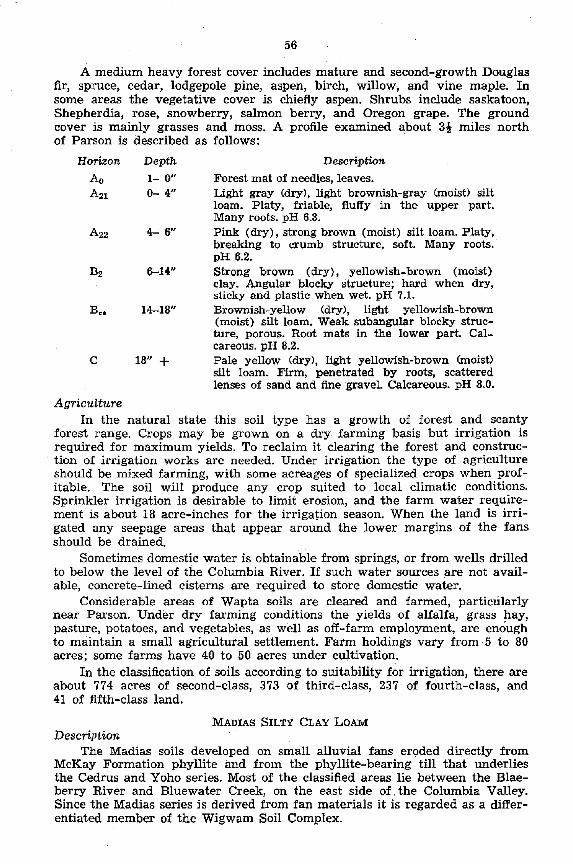
56
A medium heavy forest caver includes mature and second-growth Douglas fir, spruce, cedar, lodgepole pine, aspen, birch, willow, and vine maple. In some areas the vegetative caver is chiefly aspen. Shrubs include saskatoon, Shepherdia, rose, snowberry, salmon berry, and Oregon grape. The ground caver is mainly grasses and moss. A .profile examined about 39 miles north of Parson is described as follows:
Horizon Depth Description
Ao l- 0” Forest mat of needles, leaves. A21 o- 4” Light gray (dry), light brownish-gray Onoist) silt
loam. Platy, friable, fluffy in the Upper part. Many roots. pH 6.3.
A22 4- 6” Pink (dry), strong brown (moist) silt loam. Platy, breaking to crumb structure, soft. Many roots. pH 6.2.
B2 6-14” Strong brown (dry), yellowish-brown (moist) clay. Angular blocky structure; hard when dry, sticky and plastic when wet. pH 7.1.
BC. 14-18” Brownish-yellow (dry), light yellowish-brown (moist) silt loam. Weak subangular blocky struc- ture, porous. Root mats in the lower part. Cal- careous. pH 8.2.
C 18” + Pale yellow (dry), light yellowish-brown (mois0 silt loam. Firm, penetrated by roots, scattered lenses of sand and fine gravel. Calcareous. pH 8.0.
Agriculture In the natural state this soi1 type has a growth of forest and scanty
forest range. Crops may be grown on a dry. farming basis but irrigation is required for maximum yields. TO reclaim it clearing the forest and construc- tion of irrigation works are needed. Under irrigation the type of agriculture should be mixed farming, with some acreages of specialized crops when prof- itable. The soi1 Will produce any trop suited to local climatic conditions. Sprinkler irrigation is desirable to limit erosion, and the farm water require- ment is about 18 acre-inches for the irrigation season. When the land is irri- gated any seepage areas that appear around the lower margins of the fans should be drained.
Sometimes domestic water is obtainable from Springs, or from Wells drilled to below the level of the Columbia River. If such water sources are not avail- able, concrete-lined cisterns are required to store domestic water.
Considerable areas of Wapta soils are cleared and farmed, particularly near Parson. Under dry farming conditions the yields of alfalfa, grass hay, pasture, potatoes, and vegetables, as well as off-farm employment, are enough to maintain a small agricultural settlement. Farm holdings vary from 5 to 80 acres; some farms have 40 to 50 acres under cultivation.
In the classification of soils according to suitability for irrigation, there are about 774 acres of second-class, 373 of third-class, 237 of fourth-class, and 41 of fifth-class land.
Description MADIAS Snm CLAY LOAM
The Madias soils developed on small alluvial fans eroded directly from McKay Formation phyllite and from the phyllite-bearing till that underlies the Cedrus and Yoho series. Most of the classified areas lie between the Blae- berry River and Bluewater Creek, on the east side of the Columbia Valley. Since the Madias series is derived from fan materials it is regarded as a differ- entiated member of the Wigwam Soi1 Complex.

The topography is that of a typical alluvial fan. The main downward slope toward the valley tenter is three to five per cent but the lateral slopes
, are even gentler. Different fans are from 2,700 to 3,000 fcet above sea level. This is one of the smallest differentiated soi1 types in the mapped area, only 381 acres.
The parent material is chiefly calcareous silty clay loam, massive to weakly stratified. Evidence of relationship to the McKay Formation occurs b the form of fragments of phyllite clearly marked by white-weathered surfaces. Stones occur to a limited extent in the Upper part of the fans, but the fan aprons are stone-free. Silty clay .loam is dominant, with smaller areas of clay loam soi1 in lower parts of the fans. Small permanent streams associated with the larger fans are often used as sources of irrigation water.
Surface drainage is good under natural conditions. Interna1 drainage is to some extent restricted by the dense BP horizon, and by the parent material which drains slowly. Since fans may spread their aprons over porous and impervious materials, drainage conditions vary along their lower boundaries. Parts of fans that lie on impervious material may require underdrainage when irrigated.
The mbdium to heavy second-growth forest is chi$y aspen, wliich suc- ceeded after fire. The thick shrub layer contained soopolallie, snowberry, rose, thimbleberry, spirea, Oregon grape, etc., and the ground caver plants are heartleaf arnica, aster, pine grass and many others. A soi1 profile was examined about 14 miles north abd la miles east of the railway bridge across the Blae- berry River. This is described below:
Horizon
Ao
A2
J32
B3
CC.
C
D
Depth l- 0”
o- 7”
7- 8”
8-12”
12-17”
17-36”
36” +
Desctiption Thin layers of leaves, twigs, etc., decayed in the lower part. pH 5.8. Light yellowish-brown (moist) silty clay loam. Coarse platy structure, friable, plastic when wet. Numerous roots. pH 6.2. Very pale brown (moist) silty clay. loam. Sub- angular blocky structure, degraded on outside of peds, plastic when wet. pH 6.7. Brownish yellow (moist) silty clay loam to silty clay. Strong subangular blocky structure-compact, plastic when wet. pH 6.7. Brownish-yelIow (moist) silty clay loam. Blocky, breaking to granular structure, firm, plastic when wet. pH 7.4. Light yellowish brown (moist) silty clay loam. Blocky, breaking to granular structure, very firm, plastic when wet. Root mats in the lower part. Calcareous. pH 8.0. Light yellowish-brown (moi&) silty clay loam. Massive to weakly stratified tiith a few thin lenses of f?.ne micaceous Sand. Scattered fragments of phyllite. Calcareous. pH 8.0. An understratum at various depths. This may con- sist of till, gravels or other materiaIs covered by the fan apron.
In the above description the B3 and Cca horizons are probably altered parts of a former soi1 profile. This was buried by the outwash from which the present A and B horizons are derived. Buried profiles are common in alluvial fans.

56
Agriculture
In the native state the Madias soils are suitable for forest and forest range. They are marginal for dry farming. Reclamation requires the clearing of forest and construction of irrigation works. With irrigation, the type of agriculture should be mixed farming, with specialized crops on small acreages if profitable.
Sprinkler irrigation is recommended; the farm water requirement is about 16 acre-inches for the irrigation season. The fairly dense B horizon, and the fine-textured material beneath, needs light applications of irrigation water properly spaced in relation to rainfall. When the land is irrigated, small areas of seepage may develop in thin parts of the fan apron that overlie an imper- vious substratum, and may require underdrainage. Domestic water supplies are obtainable from small creeks that flow through the fans. If creek water is not available, concrete-lined cisterns will be required for household water storage.
Land clearing involves the removal of a dense growth of trees, most of which were small at the time of the survey. A small acreage of this soi1 type has been cleared and is used for the production of hay, pasture, grain, and vegetables. Crop yields vary with the amount of summer rainfall in areas in which irrigation is not used. Generally the rainfall is inadequate.
In the classification of soils according to suitability for irrigation, there are about 65-acres of second-class, 74 of third-class and 242 of fourth-class land.
Description NESTOR LOAM
The surface materials from which the Nestor soils are derived are chiefly loamy sediments eroded from the McKay Formation. The stony substratum has weathered from rocks of other formations. Since its soils developed on fans, the Nestor series is regarded as a differentiated member of the Wigwam Soi1 Complex. In the Upper Columbia Valley a few small areas occur on the west side between Dunbar and Bugaboo creeks. Most of these fans, from 10 to 100 acres in size, occur on the east side of the Columbia River from near Brisco to the Golden locality.
The topography is typical of alluvial fans. The main slope towards the valley tenter may be as high as 10 per cent, but usually it is not over five per cent. The lateral slopes are gentler. Minor undulations occur in areas where old stream channels are not completely filled. The soi1 areas are between 2,600 and 3,600 feet above sea level. The area classified includes 6,764 acres, of which 5,365 are potentially irrigable and 1,399 are nonarable land.
The rock faces in the regions of limited watersheds were weathered. Then, by slide or outwash, rock fans of angular stones and gravel, chiefly limestones and argillites, were formed at the toes of the mountain slopes. At a later stage of weathering, loamy sediments from the softer McKay Formation were added to the surface of the fans. On the higher parts of a fan the overlay of silt and very fine sand scarcely covers the stones but lower there is often a considerable thickness of the fine-textured material.’ The surface soi1 is loam, but in some small areas it is silt loam and fine sandy loam.
Under natural conditions the surface drainage is good, and the interna1 drainage is good to excessive. Under irrigation, the restriction of drainage im- posed by the dense B2 horizon in this type is an advantage as it lessens water losses, otherwise considerable, into the stony material beneath. Lower margins of fans that overlie impervious materials may require underdraïnage when irrigated.
The light to heavy forest is mainly Douglas fir, spruce lodgepole pine, aspen, and willow. The forest caver near Golden is being invaded by a growth

59
of Young spruce. The shrub layer is mostly rose, Oregon grape, soopolallie, and others, and the ground caver is a light growth of herbs and grasses. The soi1 profile was examined in a virgin area a quarter ,of a mile south of Harrogate and east of the highway, at an elevation of 2,850 feet. The profile is described below:
Horizon Depth Desctiption
Ao l- 0” Forest litter, decayed to black mull in the lower part.
AZ o- 2” Light gray (dry), grayish brown (moist) silt loam. Platy structure, soft and friable, porous, scattered angular stones and gravel. pH 6.5. Very pale brown (dry), brown (moist) silt loam. Weak platy breaking to subangular blocky struc- ture, vesicular, porous. Angular stones and gravel. pH 6.2.
BI 2- 6”
B2 6-11”
B-D 11-14”
D 14” f
Agriculture
Brown to dark brown (dry), yellowish brown (moist) clay loam. .Blocky to subangular blocky structure, compact. Angular &ones and gravel. pH 7.2. Brownish yellow (dry), yellowish brown (moist) gravelly sandy loam. Single grained, loose, porous, stony. pH 7.6, Light gray (dry), angular and subangular gravel, stones and Sand. Loose, porous, stony outwash. pH 7.7.
This soi1 type is now used for forest and forest range; agriculture is of minor importance. The land is marginal for dry farming and the lower classes of irrigation land have limited use. Reclamation includes the clearing of forest and stone and the construction of irrigation systems. Under ‘irrigation mixed farming cari be undertaken; most of the crops would be confined to areas where the topsoil is thick enough for annual clltivation.
Erosion should be kept to a minimum. Removal of the fine-textured surface layer would destroy the land for any agricultural purpose. Light sprinkler ap- plications, spaced with rainfall, are recommended. For the season, the water requirement is about 26 acre-inches.
Domestic water supplies cari be obtained where small creeks flow through the fans, but in most areas creek water is not available and storage in cisterns would be required for domestic use.
Trees and undergrowth vary from light to heavy, and the clearing is best achieved with machinery. In areas of moderate stoniness at the tops of the fans, reclamation for agricultural use includes the removal of stones. Stoniness is variable,. patchy, and in some cases excessive in areas otherwise suitable for reclamation. At the time of classification there were no farms on this soil type.
In the classification of soils according to suitability for irrigation, there are about 319 acres of second-class, 1,720 of third-class, 1,464 of fourth-class, 1,862 of fifth-class, 1,382 of excessively stony, and 1’7 of rough broken land.
4. Podzolized Gray Wooded Soils
This soi1 group occurs in association with Gray Wooded soils in the Frances Creek area west of Steamboat Mountain, and between Parson and Donald. These soils are generally dominant in the area from Donald to the north limit of the mapped area.

60
The Gray Wooded and Podzolized Gray Wooded soils may occur side by side because of differences in the amount of weathering near the surface. The _ intensity of weathering is governed by the prevailing conditions of humidity and temperature and the composition of the parent material. Drainage condi- tions also greatly influence the degree of weathering. Materials that weather easily under good drainage conditions may be more resistant when there is poorer drainage, thus giving rise to Podzolized Gray Wooded soils in areas of good drainage and Gray Wooded soils in places of restricted drainage. In these conditions, the two stages of soi1 development may be SO intimately associated that in mapping them differentiation is not feasible.
Under greater precipitation in the northern section, the characteristics of the Podzolized Gray Wooded soils are,more strongly developed. The soils of this region tend to develop as podzols; this is thought to be due to a greater silica content of the calcareous parent material than in the soils farther south. The podzols are between the north limit of the surveyed area and the Boat Encampment.
Horizons and subhorizons of the Podzolized Gray Wooded profile are dis- tinguished by the subscript “p” as in ARP, BD and C,. Any remaining Gray Wooded soi1 horizons in the profile are referred to by the subscript ‘rgw7’. The common characteristics of the Podzolized Gray Wooded profile are:
Horizon
Ao
A2p
B*
CP
B2sn
Description Dark brown accumulation of forest litter one half inch to two inches thick. White and pinkish gray to light brownish gray. Platy structure, from one half to two inches thick. Brown to strong brown, weak crumb structure, friable, from one to six inches thick. Very pale brown to light yellowish brown, weak platy to subangular blocky structure, slightly com- pact and harsh, from two to 10 inches thick. Yellowish-brown to olive brown, blocky, compact, heavy-textured, from one to eight inches thick.
As noted above, the podzolization is in a secondary profile in the A2 horizon of the Gray Wooded soi1 profile. The new profile is from a few inches to 15 inches thick. It is distinguished by a thin, “ashy” A2P horizon much lighter in color -and more acid than the A2gw horizon in which it develops. The BP horizon of the podzol is brown to strong brown with weak and friable crumb structure and no compaction. This is underlain by a pale brown to light yellowish-brown horizon with structure that tends to vary from weakly platy to weak subangular blocky forms that are harsh to feel and slightly compact.
Below the C, horizon the Gray Wooded soi1 profile may exist either as comparatively unaltered material or in various stages of decomposition. Where disintegration is taking place the B2 horizon of the Gray Wooded soils loses textural and structural characteristics, and horizon B,, loses alkaline earths.
Eight series of Podzolized Gray Wooded soils were differentiated in the mapped area. These are Yoho Clay Loam, Dogtooth Sandy Loam, Bugaboo Silt Loam, Blaeberry Silty Clay Loam, Palliser Very Fine Sandy Loam, Narboe Sandy Loam, Purcell Silt Loam and Golden Sandy Loam.
Description YOHO CLAY LOAM
In the Yoho series is included a group of Podzolized Gray Wooded soils developed from calcareous till that eroded chiefly from the Paleozoic McKay Formation. The phyllite content of the Clay Loam varies more than in the

61
Cedrus series, and there is more coarse, easily weathered material. The Yoho Clay Loam occupies parts of the mapped area from about four miles south of Parson to Bluewater Creek.
The topography consists of long, comparatively narrow moraines that run parallel to the main valley. They have undulating to steeply rolling surfaces, the main slopes being east and west. Here and there the ridgelike moraines are cross-eut by the gullies of tributary streams. The lowest soi1 area is at about 3,000 feet elevation near the valley tenter and the highest areas lie along the mountain boundary at about 4,200 feet above sea level. The classified acreage amounts to 13,193, of which 2,531 acres are rough broken land.
Figure 9. Farmstead mi Yoho clay loam. The Rocky Mountains in backgromd.
The parent material is a compact limy till of clay loam texture, containing various amounts of stones and gravel. The till is from a few feet thick to 50 feet or more. It lies on bedrock and also on stratified silts and gravels. Be- tween the Blaeberry and Kicking Horse rivers, the till is strongly influenced by the McKay Formation, which outcrops in this area, and the resulting soi1 has a heavier texture than average.
The soi1 is, mainly clay loam, with small areas of silt loam and silty clay loam. Just beneath the layer of forest .litter it. is often very fine sandy loam, due to the‘downward movement of the finer materials. Stones and grave1 are. scattered, but there are a few stone patches. Surface drainage is good on sIopes and poor in depressions that have no drainage outlets, but the depressed areas are small. On slopes the internal drainage is good in the Upper soi1 horizons and is restricted by the B2gW horizon and by the compact parent material.
The medium to heavy second-growth forest follows logging and fire. Douglas fir, lodgepole pine, aspen, birch, willow, and Douglas maple are the main trees. These are augmented north of Moberly by spruce, cedar and hem-

62
lock. The well-shaped shrubs include soopolallie, rose, saskatoon, Oregon grape, and mountain ash. The ground caver includes pine grass, aster, twin iiower, moss and other plants.
The profile described below was examined about five miles north of Golden, on the east side of the valley:
Horizon Depth Ao 4- 0”
AZP o- 1”
B21* l- 5”
B22o
C*
5- 1”
7-11”
B2r.v 11-14”
14-18”
C 18” +
Agriculture
Description Forest litter, well decomposed in lower part. White to light gray (dry), light brownish-gray (moi&) fine sandy loam. Single-grained, wavy, soft, friable. Many small roots. pH 5.4.
Strong brown (moist) loam. Weak crumb struc- ture, soft, friable. Scattered stones and gravel. pH 6.2.
Yellowish-red (dry) to reddish-yellow (moist) silty clay loam. Weak platy structure; gritty, scattered stones and gravel. Discontinuous. pH 6.5. Light yellowish-brown (dry), pale yellow (moist) silt loam to silty clay loam. Vesicular, breaking to medium subangular blocky structure; hard when dry, plastic and sticky when wet. Scattered stones and gravel. pH 6.2.
Light olive brown (dry or moist) clay. Medium to large subangular blocky structure projecting down- ward along roots. Scattered stones and gravel. pH 7.0. Light olive brown (dry), light brownish gray (moist) clay loam. Massive, compact, organic accumulations in root channels. Scattered root mats. Stones and gravel. Calcareous. pH 8.0.
Light yellowish-brown compact till of clay loam texture. Variable thickness and stone content, scattered grave1 and fragments of phyllite; hard when dry, sticky and plastic when wet. Breaking along horizontal planes to subangular fragments. Impervious. Calcareous. Roots penetrating frac- tures in Upper part. pH 8.0.
In 1954 most of the Yoho Clay Loan soi1 area supported forest caver. Its value as range is limited. In areas of moderate topography that are fairly free of stones the type is suitable for irrigated mixed farming. Reclamation includes the clearing of forest, the removal of stones, and the construction of irrigation systems. A farm water requirement of 20 acre-inches per season should be applied by sprinklers.
The dense lower part of the l3 horizon and the impervious till beneath Will restrict the movement of excess irrigation water, and cause saturation on slopes and seepage or pounding of depressions. This difficulty, in the main, is pre- ventable by applying light irrigations only as required and supplying drainage if necessary.
Erosion or levelling cari expose the lower part of the B horizon or the till beneath, thus leaving plants to grow on subsoil or geological material, either of which is infertile. Stoniness is not severe except in a few small areas. In areas of moderate topography, farm units of adequate size could be developed.

63
Because of the well-drained topography, well water is rarely obtainable. Water for farm use Will have to be stored in cisterns. In areas underlain by thick, impervious till, unlined dugouts may be used to store water for livestock, but concrete-lined and -covered cisterns would be necessary for water storage for household purposes.
Some small areas have been cleared, cultivated and irrigated, and are used for mixed farming. The land produces alfalfa, hay, small fruits and vege- tables, but the areas cleared are too limited for full-scale farming. They are used chiefly as small holdings for loggers and others who make most of their living by off-farm employment. The high cost of clearing and the lack of a low- cost water supply hold back development. A number of small clearings, long abandoned, are reverting to forest.
In the classification of soils according to suitability for irrigation there are 955 acres of third-class, 3,041 of fourth-class, 6,666 fifth-class and 2,531 of rough broken land unsuitable for irrigation.
Description BUGABOO SILT LOAM
West of Steamboat Mountain, between Frances Creek and the Spillimacheen River, there is an area of Wycliffe till covered by gravelly outwash. The soi1 type derived from the outwash, and other material deposited over the till, was named the Bugaboo series.
The Bugaboo soils have till-plain topography, tut here and there by sub- sequent stream channels. The surface is drumlinized and morainic. The drum- lins vary from rounded, narrow hills, often with bedrock cores, to groups of rounded hills with slopes up to 25 per cent running in a11 directions. The morainic areas have moderate to strongly rolling relief. The elevation of these soils ranges from 3,000 to 3,600 feet above sea level. The total area mapped amounts to 6,955 acres.
Melt-water from decaying glacier ice deposited a few feet of roughly strati- fied gravels, stones, and boulders on the till, without modifying the till-plain topography. After this stage of deposition the whole area was surfaced with a thin layer of loess, from which the soi1 in part developed. The surface soi1 texture is mainly silt loam, with minor variations of loam and sandy loam. The amounts of gravels, stones, and boulders at the surface vary widely. Coarse surface material is most abundant where it was brought to the surface by the uprooting of trees.
Surface and interna1 drainage is good to excessive. Drainage is arrested, how- ever, by impervious till at three to six feet deep. Tree roots obtain moisture from the surface of the till, and underground moisture is most abundant in depressions, due to impeded drainage.
The climax forest ‘was mainly Douglas fir, but in most of the area the mature timber has been logged or destroyed by fire. The existing forest is a medium heavy stand of lodgepole pine, with scattered spruce and willow in the hollows. The thin ground caver consists of a few shrubs, herbs and grasses.
A site at an elevation of 3,540 feet just west of Steamboat Mountain was selected for profile examination. The description is given below:
Horizon Depth
Ao 2- 0”
AZP o-1qn
Description Forest litter, raw on top and well decayed in the lower part. Pale brown (dry), dark yellowish brown (moist) silt loam. Platy, porous, friable. pH 6.0.

64
Horizon
BP
CP
Dl
Jh
Dz
Depth 1&7&”
73-13”
13-21”
21-34”
34” +
5’ +
Description Yellowish red (dry), redclish brown (moist) silt loam. Weakly platy breaking to granular structure, porous, friable, thickly permeated by small roots. Scattered stones and gravels. pH 5.8. Brownish yellow (dry), yellowish brown (moi&) loam. Weakly platy breaking to granular structure, firm, porous. Permeated by roots. Much grit, gravels and stones. pH 6.5. Yellowish brown (dry or moist) pockets of clay loam in a matrix of stones and gravels. The clay loam accumulates between the stones and has blocky, breaking to crumb structure. Permeated by roots. pH 7.1. Dark yellowish brown (moist) matrix of stones and gravels. Sorted outwash. Stony glacial outwash, penetrated by roots. Lime plating on lower parts of stones. Calcareous, impervious till, similar to the till underlying the Wycliie series, average depth about five feet.
Agriculture
The Bugaboo Silt Loam is a forest soi1 type, with limited value as forest range. The topography is too rough and the soi1 too stony and gravelly for agriculture under present economic conditions or those of the foreseeable future. The land should be taken over by the Forest Service for management purposes, or included in a Forest Management Licence.
Description DOGTOOTH SANDY LOAM
The Dogtooth series is derived from a comparatively thin layer of glacial outwash that overlies the till parent material of the Cedrus series. Scattered areas of this soil series extend from near Parson to Donald.
The topography of uneroded areas is gently sloping to rolling, with a few slopes over 10 per cent. This kind of relief is representative of modified till- plain. Sections of the area are rough and broken by numerous gullies that have destroyed the, land for agriculture. The elevation ranges from 2,700 to 3,100 feet above sea level. The total acreage is 1,793 of which 793 have moderate topography and 1,000 are severely eroded.
The parent material is a secondary deposit of calcareous sandy loam be- tween one and 2& feet thick, containing variable amounts of stones and gravels. This material was laid over pre-existing till by melting glacier ice. Since it is a more or less uniform deposit it conforms to the topography of the underlying till. The soi1 profile is porous, with an impervious stratum beneath. The natural drainage is good on slopes and poor in depressions. Down-slope seepage would occur under irrigation, requiring underdrainage at the toes of slopes, and de- pressions also would require drainage.
Between Moberly and Donald, areas of Dogtooth Sandy Loam have been burned over or logged, and the new growth is lodgepole pine and aspen, with some willow, aider and birch. In places Young Douglas fir, spruce, and some hemlock are coming in. A few small plots of mature Douglas fir and spruce occur in moderate stands which could be logged, ‘and cedar was observed in gullies and depressions. The shrubs are chiefly soopolallie, thimble berry, spirea,

65
rose and Oregon grape, and the ground caver contains various herbs and pine grass. A profile 14 miles north of the Blaeberry railway bridge was examined and described as follows:
Horizon
Ao
AZP
Depth l- 0”
Desctiption
B3
.DI
Dz 24” +
o- 4”
a- 4”
4- 7”
7- 9”
9-18”
18-24”
Leaves, needles, dead grass, the lower part decayed and full of small roots. pH 5.4. White (dry), light brownish-gray (moist) sandy loam. Coarse and weak platy structure, friable and discontinuous. pH 6.4. Reddish yellow (dry), strong brown (moi&) sandy loam. Weakly blocky breaking *to granular struc- ture. Friable, porous. Subangular gravels and stones. Numerous roots. pH 6.7. Very pale brown (dry), brown to strong brown (moist) sandy loam. Weakly blocky breaking to granular structure. Friable. Subangular gravels and stones. Numerous roots. pH 7.1. Yellow (dry), brownish-yellow (moist) gravelly sandy loam. Weakly granular, loose, with blocky structure in pockets between subangular stones. pH 7.4. Yellow (dry), olive brown (moist) loam-textured sandy loam. Weakly granular. Subangular stones. Calcareous. pH 7.8. Yellow (dry), olive brown (moist) loam-textured and weathered till. Massive, compact. Root mats up to two inches thick in discontinuous layers. Sub- angular gravels and st,ones. Calcareous. pH 7.8. Yellow (dry), olive yellow (moist) loam-textured till. Massive, breaking to angular fragments. Com- pact, impervious. Scattered gravels and stones. Calcareous. pH 8.0. . .
Agriculture The Dogtooth Sandy Loam is used for forest and rather scanty forest range.
The soils are marginal for dry farming, because of low water-holding ca- pacity of the solum. Reclamation includes clearing the forest and stones and provision for irrigation. Under irrigation the type of agriculture should be mixed farming, with emphasis on sod crops. Whenever possible the farm acre- age should include a soi1 type that has a wider range of use.
Sprinkler irrigation is recommended, with applications as required and spaced in relation to rainfall. The farm delivery requirement is estimated at 22 acre-inches per irrigation season. Farm water supplies cari be obtained from small permanent creeks, and from Wells in creek beds. If necessary, water cari be stored in concrete cisterns for domestic use, and in dugouts for stock use in areas in which the underlying till is thick and impervious.
The cost of clearing forest with machinery is moderate in recently burned areas that support a light caver of new growth. Stoniness varies in density, and stone removal is necessary. A few small clearings on this soi1 type have a11 been abandoned f,or many years. The grass caver on these clearings was used as com- mon pasture at the time of the survey.
In the classification of soils according to suitahility for irrigation, there are about 793 acres of fifth-class land, and 1,000 rough, broken and unsuitable for farming.
96489-O-5

66
Description NARBOE SANDY LOAIM
In the classified area, the Narboe Sandy Loam developed on river terraces in the section between Canyon Creek and Rlackwater Creek. The fine-textured solum of the Narboe soils is derived from erosion products of the phyllite- carrying McKay Formation.
The topography is gently sloping on terraces of variable size. There are slight slopes at right angles away from existing stream channels, and very gentle downstream slopes. The lowest terraces are near Waitabit Creek at 2,520 feet elevation. The terraces that line Canyon Creek range from 2,960 to 3,080 feet in elevation. The highest terraces, at the Upper part of the Blackwater Creek, are about 3,180 feet above sea level. The total area mapped amounts to 3,362 acres, of which 2,824 are potentially irrigable and 538 are excessively stony.
The main features of the soi1 profile are a fine-textured surface layer above stratified terrace gravels that are from a few feet to 50 feet thick. The com- paratively thin layer of surface soi1 is mainly sandy loam, with inclusions of loam. Small areas of loam are confined to a few terraces along the Blaeberry River. The large terraces of sandy loam, near Bluewater and Blackwater creeks, comprise most of the acreage.
The depth of the soi1 to subsurface grave1 varies from 10 to 18 inches; the stones are from one inch to a foot or more in diameter. Stoniness varies from light to excessive. The gravels contain considerable amounts of Sand, and some- times schistose materials from the McKay rocks. The terraces on the south side of Bluewater Creek have a cobbly D horizon and are more excessively drained than other mapped areas of the type. Drainage of the soi1 profile is good to excessive, depending mainly on the thickness of the fine-textured solum. Since the Bz horizon is discontinuous and comparatively thin, it would not restrict a downward movement of excess irrigation water. The Narboe profile was mapped as a Podzolized Gray Wooded soil. The precipitation increases sharply toward the north end of the mapped area and podzol development is most pronounced there.
Most of the terraces have been burned over and now support growths of lodgepole pine of various densities. In the southern section the pine is being replaced by Douglas fir and spruce; in the north the Young trees include spruce, cedar, hemlock, and white pine. There are many shrubs, herbs, grasses, and mosses. The soi1 profile, from a site about 24 miles north of the Bluewater Creek bridge, near the Big Bend highway, is described as follows:
Horizon Depth Description
Ao l- 0” Forest litter, with scattered caver of moss. A!& o- y Light brownish gray (dry), grayish brown (moist)
silt loam. Weak platy structure, friable. pH 5.7. BP $- 5” Strong brown (dry), red-dish brown (moist) sandy
loam to silt loam. Weak crumb structure, friable, porous. Scattered stones and gravel. pH 6.2.
CP 5-64” Strong brown (dry), brown to dark brown (moist) sandy loam. Weakly platy breaking to weak crumb structure. Friable, porous. Scattered grave1 and bits of schist. pH 6.0.
52SW Si-113” Grayish-brown to yellowish-brown (dry), very dark grayish-brown (mois0 gravelly sandy loam. Weakly developed medium subangular blocky structure. Friable, porous. Many fragments of schist and phyllite. pH 7.2.

67
Horizon Depth Description B-D,, Il&-18” Grayish-brown to dark yellowish-brown (dry),
dark grayish-brown (moist) gravelly sandy loam. Structureless, loose. Many grave1 and schistose fragments. Calcareous. pH 8.0.
D 18” + Stratified terrace grave1 and stones containing flat fragments of schist. Loose, porous. Calcareous. pH. 8.0.
Agriculture These soils, without irrigation, are suitable only for forest &rd scanty
forest range. Reclamation includes clearing of forest and surface stone, and construction of irrigation works. Under irrigation the Narboe soils have some value, particularly for sod crops. Cultivation should be kept to a minimum because of the thin solum. Potato and root vegetable crops should be confined to places where the stone-free topsoil is deep enough for annual cultivation.
Under irrigation the type of agriculture should be dairying and beef production, and the land should be subdivided SO that the farm acreage would include a more productive soi1 type. In order to water the land most efficiently, light sprinkler irrigations should be capplied as required to supplement rainfall. The farm delivery requirement for the irrigation season is about 30 acre- inches. Irrigation water must be piped or flumed to the land because of the porous, gravelly substratum:Domestic water is not available from Wells and would have to be stored in concrete cisterns.
The land cari be cleared of the comparatively dense stand of trees with machinery. The clearing requires minimum disturbance of the soil, SO that as little grave1 as possible is dragged to the surface when the trees are removed. Excess surface stones should be removed, to permit occasional cultivation and to limit excessive wear on machinery.
About 81 acres of this soi1 were cleared, in the past, in a number of scatkred patches, chiefly in areas of deeper than average solum. At the time of classification about 62 acres were abandoned and 19 still received casual attention. On one or two patches fair crops of grass hay, alfalfa, and grain were produced despite inadequate flood irrigation, indifferently applied. These pioneer efforts indicate a possibility of profitable farming under good manage- ment, on a limited-use basis.
In the classification of soils according to suitability for irrigation, 2,824 acres of potentially irrigable Narboe soils were grouped as follows: 14 of third-class, 142 of fourth-class, and 2,668 of fifth-class land. About 538 acres are excessively stony and unfit for cultivation.
Description WOXAH SANDY LOAM
The Wonah soi1 type is derived from sandy terraces, and in the mapped area it occurs along the channels of Blackwater and Bluewater creeks. The topography of the area is level to gently undulating, with few slopes above four per cent, and its elevation is about 2,700 feet. This soi1 type occupies only 615 acres and is one of the smaller ones in the classified area.
The calcareous parent material is medium to coarse sandy loam containing scattered fine gravel. This is underlain by coarser sandy strata, which include scattered rounded gravel, small and angular Aaky bits of McKay material, and rolled pebbles of stratified clay. The soi1 is porous and well drained.
The tree caver is a moderately thick stand of lodgepole pine about eight inches in breast-high diameter and 60 feet tall. There are minor inclusions of Douglas fir, cedar, and hemlock. A fairly dense ground caver contains soopo- lallie, copper bush, spirea, kinnikinnick. Douglas aster and pachystima.
96489-0-$8

68
The disturbed conditions characteristic of most of the mapped area are the result of recurring fires and falling trees. The trees of the dominant species on these soils are not well anchored and the windfalls are more numerous than were observed on other soils. Under these conditions the parent material is mixed into the solum to various degrees. The profile has not had a chance to develop evenly. Study of relatively undisturbed profiles indi- cates that the Wonah Sandy Loam is a Podzolized Gray Wooded soil. A description of a profile with better than average development follows:
Horizon Depth Description Ao 2- 0” Forest litter, chiefly pine needles. pH 5.1. -42r o- 1” Light gray (dry), light brownish-gray (moist)
very fine sandy loam. Single grained, friable, patchy. Best developed under rotting logs. pH 5.6.
BI, l- 5” Strong brown (moist) sandv loam. Single-grained, loose. Containing fine angular fragments of schist and scattered fine gravel. Wavy. pH 6.3.
B2P 5- 7” Yellowish-brown (moist) coarse sandy loam. Single-grained, loose. Not continuous. pH 6.2.
CP 7-13” Light olive brown (moist) coarse sandy loam. Single-grained, loose. Containing fine angular schist fragments and scattered gravel. Of various thick- nesses. pH 6.2.
B2SW 13-16” Olive brown (moist) sandy loam. Weak blocky structure. Containing fine schist fragments and scattered gravel. Wavy. pH 7.1.
BC, 16-18” Light .olive brown (moi&) coarse sandy loam. Single-grained, loose, micaceous. Schistose frag- ments and scattered gravel. Calcareous. pH 8.0.
C 18” + Coarse dark-colored sandy loam. Single-grained, micaceous. Containing very fine fragments of schist, scattered grave1 and rolled pebbles of stratified clay. Thin layers of silt at various depths. pH 8.0.
Agriculture In the natural state the Wonah series produces a medium stand of forest
but little or no range for cattle. At the time of the soi1 survey no acreage had been cleared for agriculture. The land would be marginal under dry farming, but with irrigation it would become productive. Clearing of forest is moderately heavy, but nc stone removal is necessary. Sprinkler irrigation is recommended. The farm delivery requirement for sprinklers is about 30 acre-inches of water for the season. Domestic water is obtainable from Wells on ter-races close to streams, but at distance from flowing’streams or on higher terraces the house- hold supply might require storage in cisterns.
In the classification of soils according to suitability for irrigation, there are 212 acres of fourth-class and 403 of fifth-class land.
Description PALLI~ER VERY FINE SANDY LOAM
In places the parent material of the Blaeberry series was covered by a shallow layer of fine sands, and the soi1 type that subsequently developed was differentiated as Palliser Very Fine Sandy Loam. This soi1 is near the Blaeberry River in the mapped area.
The topography ,of a 56-acre area is gently undulating with long two to three per cent slopes, but it has a microtopography of small humps and hollows formed by falling trees. In addition, there are about 30 acres in two narrow, steeply sloping areas, and 17 acres in one area of eroded land. The elevation

69
of the 104 acres of classified soi1 of this type ranges ‘from 2,720 to 2,740 feet. There are four areas of the fine sandy parent material overlying the finer lacustrine sediments at depths ranging between six and 36 inches. These areas are remnants of subaqueous fans and mark the points of drainage into a former glacial lake. The soi1 texture is uniform and there are no stones or gravel. The clay forms a semi-impervious layer below the porou% Sand, causing restricted drainage. The effect of such restriction on vegetation depends on the topographical position and the depth of the Sand. The soi1 is droughty for dry farming. With irrigation, the clay layer would cause a variety of seepage conditions requiring underdrainage.
The forest is a light to moderately heavy second growth of aspen and lodgepole pine, with some scattered Young spruce. The nature and density of the growth is similar to that of the Blaeberry series; it is growth succeeding a severe burn. The soi1 profile was examined near an east-west road about half a mile north of the Upper Blaeberry River bridge. The description is as follows:
Horizon Depth Description Ao 2- 0” Forest litter, decayed in the lower part. pH 6.1. AZP o- 2” White (dry), Iight gray (moist) very fine sandy
loam. Weakly platy breaking to crumb structure. Porous, friable, micaceous. Wavy. Many roots. pH. 5.5.
BD 2- 5” Strong brown (dry or moist) very fine sandy loam. Weak crumb structure. Friable, porous, micace- ous. Many roots. pH 6.3.
CP 5-15” Pale yellow (dry), light yellowish-brown (moist) very fine sandy loam. Very weak crumb structure. Micaceous, porous, friable. pH 5.8.
B2sw 15-16” Very pale brown (dry), light yellowish-brown (moist) loam. Subangular bl’ocky structure. pH 6.1.
B-D 16-20” Very pale brown (dry), light yellowish-brown (moist) clay. Small subangular blocky structure, sticky and plastic when wet. pH 6.4.
D 20” + Very pale brown (dry), light yellowish-brown (moi&) clay. Stratified, varved, semi-impervious. Micaceous sandy layers about one inch thick in Upper part. The parent material of the. Blaeberry series. pH 7.7.
Agriculture In the natural state the Palliser series produces forest. Its value as range
land for cattle is limited. Under cultivated crops and without irrigation, this soi1 type is marginal as agricultural land; its value would be increased by irrigation although drainage problems would develop.
This is an easy soi1 to cultivate and in most of the area the topography is good. Light sprinkler irrigation, in applications ,properly spaced with rainfall, is recommended. The farm delivery requirement is about 22 acre-inches for extremely dry summers and somewhat less in years of greater rainfall. Some domestic water is available from creeks, but little or no water may be obtained from Wells. In some places cisterns Will be required for storage of the domestic SUPPlY.
Machinery is needed in land reclamation to remove the moderately heavy stand of trees. However, no stone removal is required. At the time of classifica- tion one settler had about 15 acres under cultivation. A small acreage had been abandoned. The land was dry-farmed and produced a light trop of grass hay. The type is more suitable for grass hay than alfalfa under irrigation, because o£ the impeded drainage resulting from the impervious substratum. With adequate watering, cool-season vegetables would do well.

.
70
In the classification of soils according to suitability for irrigation, the Palliser Very Fine Sandy Loam has about 56 acres of second-class, 30 of fourth- class, and 18 of fifth-class land.
Description PURCELL SILO LOAM
In the northern part of the classified area, some of the higher river and stream terraces are surfaced with calcareous silts, beneath which are sands and gravels. The Podzolized Gray Wooded soils that developed on this material were named the Purcell series. Most of the terraces having Purcell soils are small and narrow. They occur from near Donald to Blackwater Creek.
The topography varies from nearly level to gently undulating, with occas- ional depressions of old stream channels that lie from five to 10 feet below the general surface. The lowest terrace, at an elevation of 2,520 feet, is on the west side of the Columbia Rive’r about a mile south of Donald, and the highest elevation, 3,130 feet, is on a Blackwater Creek terrace. The total area classif?ed is 1,069 acres.
The eluviated soi1 horizons have weathered to silt loam from stratified silty clay loam parent ‘material. The parent material is from 15 to 30 inches thick. This stone- and gravel-free deposit overlies layers of sands and gravels up to several feet in thickness that may alternate with similar layers of strati- fied silt, clay, and silty clay. The soi1 drainage is impeded under natural conditions. Under irrigation the interna1 drainage may be restricted in areas under which the parent material has greater than average thickness, or where layers of silt or clay in the substrata impede the movement of excess water.
The forest is chiefly a fairly dense stand of lodgepole pine and aspen, .with a Young growth of Douglas fir, spruce and cedar coming in. There is a fairly thin undercover of shrubs, pine grass and moss.
The profile described below is on a terrace about 75 feet above the road, about a mile north of the Waitabit Creek bridge on the Big Bend highway.
Horizon
Ao
A21>
B*
CP
B2WV
Depth l- 0”
o- 9”
&- 4”
4- 7”
8- 9”
9-l 2”
C 12-30”
Dl
D2
30-45”
45” +
Description Forest litter with discontinuous moss caver. pH 4.7. White (dry), light yellowish-brown (moist) loam to silt loam. Weak platy structure. Friable. pH 4.7. Reddish-yellow (dry), strong brown (moist) loam. Weak crumb structure. Friable, porous. pH 5.7. Pale yellow (dry), yellowish-brown (moistj silt loaun. Weak platy structure. Friable, porous. pH 5.7. Yellowish-brown (dry or mois0 clay loam to silty clay loam. Medium subangular blocky structure. Porous in cleavages. pH 6.2. Yellow (dry), olive yellow (moist) silty clay loam. Weak, medium subangular blocky structure. Fri- able, porous. Weakly calcareous. pH 7.8. Light yellowish-brown (dry or moist) silty clay Ioam. Finely stratified. Friable. No stones or gravel. Calcareous. pH 3.0. Grayish-brown to light olive brown (dry) coarse Sand and gravel. Loose, porous. Very few stones greater than two inches in diameter. Stratified. Calcareous. pH 8.1. Light yellowish-brown (dry or mois0 silt loam. Stratified, compact, semi-impervious. Calca&ous. pH. 8.0.

71
Development of a Podzolized Gray Wooded soi1 with silty clay loam texture is noteworthy. The comparatively thin solum is due to impeded drainage caused by the heavy texture and flat topography, which combine to restrict the depth of soi1 horizon development.
Agriculture In 1954 the Purcell Silt Loam was utilized for the products of the forest
and for scanty range. When reclaimed it may be used for dry farming, but for maximum production the summer rainfall should be supplemented with irrigation. The soi1 cari produce any trop that Will mature in the local climate.
Either flood or sprinkler irrigation is necessary in dry years and helpful in most years. The farm delivery requirement for sprinkler irrigation is about 16 acre-inches; the flood irrigation requirement is about one third more. Domestic water is obtainable from Wells on low terraces close to streams, but on the higher terraces would have to be stored in cisterns lined with concrete.
Land clearing involves removal of a dense stand of trees, some of which were three feet in diameter at breast height at the time of the soi1 survey. The only cleared acreage is on the west side of the Columbia River south of Donald. When this was classified the dry farming consisted in removing an annual Crop of alfalfa, timothy, and alsike clover hay from land under sod for many years. Even under these conditions the amount of growth was con- siderable, indicating that it is a potentially good agricultural soil.
In the classification of soils according to suitability for irrigation, there are about 566 acres of second-class and 503 of third-class land.
1
Description BLAEBERRY SILTY CLAY LOAM
The Blaeberry Silty Clay Loam has developed on a glaciolacustrine deposit of calcareous silty Clay material. It occurs in shallow depressions in the till on the north side of the Blaeberry River. Originally of greater extent, the area was reduced by river erosion along the southern boundary and covered in places by alluvial fans.
Figure 10. Topography and vegetation, Blaeberry silty clay loam.

72
The topography varies from gently undulating to gently rolling. A large depression in the tenter of the deposit is occupied by 176 acres of swamp. Slopes average about two or three per cent, occasional slopes being up to six per cent. A microrelief of small humps and depressions is caused by the uprooting of trees. The elevation varies from 2,700 to about 2,790 feet, and the total area mapped is 570 acres.
The parent material is varved silty clay loam, compact and slow-draining. The deposit, about 20 feet thick, has glacial till beneath. A gravelly and sandy beach, too narrow for differentiation, marks the old shoreline at 2,790 feet elevation. The parent material is derived chiefly from the McKay Formation, and the texture is uniform, except for some small areas along the outer boundaries.
The vegetation is coniferous and deciduous forest, mainly lodgepole pine and aspen, with scattered spruce coming in. The tree growth is of medium to heavy density, under which the shrubs are mainly soopolallie, rose, Oregon grape and juniper. There are many herbs, including aster, wintergreen, straw- berry, violet and a few grasses. A soi1 profile from an area about one mile north and lf miles east of the railway bridge over the Blaeberry River is described as follows:
Horizon Ao
A?,
Depth
4- 0”
o- 2”
BP 2- 4”
CP 4- 6”
BL!X” 6-13”
B,. 13-16”
C 16” +
Agriculture’ In 1954 the Blaeberry Silty Clay Loam produced forest and limited range
for cattle. When reclaimed, in dry farming good to fair crops are produced in three out of five years. Under irrigation, the Blaeb.erry soi1 cari give sus- tained yields of a11 crops that cari be produced in the local climate.
Description Forest litter. The lower part is decayed, contains charcoal, and is permeated by roots. White (dry), light gray (moist) loam. Weakly platy, (breaking to fine crumb structure. Friable, porous, very thin in places. pH 5.4. Very pale brown (dry), light yellowish-brown (moist) silty ,clay loam to clay loam. Weakly platy breaking to crumb structure. Vesicular, fri- able, sticky and plastic when wet. Wavy. Many roots. pH 5.2. Pale yellow (dry), light yellowish-brown (moist) silty clay to clay loam. Weak blocky, breaking to fine crumb structure. Friable, sticky and plastic when wet. Horizon discontinuous. pH 6.2. YellowishLbrown (dry or mois0 silty clay loam to silty clay. Subangular blocky structure. firm. Dark brown coatings on peds. Wavy. pH 7.1.’ Pale yellow (dry or moist) silty clay loam. Crumb structure in mixture of stratified fragments, friable. Wavy. Slightly calcareous. pH 7.8. Yellow (dry) light olive brown (moist) silty clay loam to clay. Stratified, varved, hard when dry, sticky and plastic when wet. Slow-draining. Cal- careous. pH 8.1.
Sprinkler irrigation is recommended, the farm delivery requirement being about 16’ acre-inches for the irrigation season. Irrigation applications should be spaced between summer rains. Domestic water is not obtainable from Wells; water should be stored in cisterns for household use.

73
At the time of classification land of the Blaeberry series could be cleared with machinery at reasonable cost. The trees, a medium heavy stand, were not large, and the last burn had cleared away the old logs and stumps. Agri- cultural development amounted to four farmsteads ranging in size from eight to 30 acres. An attempt, long abandoned, was made to irrigate one of these holdings, but a11 are now dry-farmed. The crops are grass hay, alfalfa, and kitchen gardens. There are a few dairy cattle and some other stock. The farms are not large enough for family support, and most of the settlers’ in- cornes are derived from off-farm employment.
In the classification of soils according to suitability for irrigation, there are 514 acres of second-class, 29 of third-class and 27 of fourth-class land.
Description GOLDEN SANDY LOAM:
The Golden Sandy Loa,m is derived from complete alluvial fans, and SIX- viving sections of compound fans that are well above the present level of drain- age. In limited areas the type occurs from near Parson to Donald on the high ledge on the east side of the yalley.
The major features in the topography of complete fans are a main slope toward the valley tenter and minor slopes at right angles on each side. Minor undulations also occur. Slopes near the fringe of the fan apron are about two per cent, grading up to about 10 per cent or more near the mouth of the coulee that supplied the material. The elevation ranges from 2,600 to 3,650 feet and the area mapped amounts to 4,148 acres. An additional 995 acres was mapped in, combination with the Yoho series as Golden-Yoho soils.
The parent material is calcareous, stony sandy loam that overlies a gravelle substratum containing variable amounts of stones. The gravelly and stony sub- stratum was formed by a succession of outwashes that cleared away fine material and left the stones and grave1 in place. The stony, gravelly mass is sur- faced by a thin veneer of sandy loam that does not bury the top layer of stones. Stones have also been brought to the surface by the uprooting of treeS. Since the Golden series is derived from fan material, the Golden. Sandy Loam is regarded as a differentiated member of the Wigwam Soi1 Complex.
The top layer of sandy loam, with a few small areas of loam, is seldom more than 15 to 24 inches thick over the coarse and porous substratum. This in turn overlies older deposits, some of which are impervious to thé downward move- ment of water. Under natural conditions the Golden series is excessively drained in the Upper parts of fans. Drainage may be restricted in sections of fan aprons where a thin deposit of fan outwash overlies impervious material of different origin.
The forest caver varies from light to heavy, depending on the stage of growth after logging or fire. The trees are chiefly second-growth Douglas fir, spruce, lodgepole pine, birch, aspen, and willow. The moderate growth of shrubs and herbs includes soopolallie, rose, saskatoon, pine grass, ,and mass.
A soi1 profile was examined at 3,390 feet elevation at a point shown on the soi1 map, about 16 miles southeast of Golden. This is described as follows:
Horizon Depth
Ao l- 0” -42n o- 1"
BP l- 8"
Description Forest litter, well rotted in the lower part. Pinkish gray (dry), brown (moist) fine sandy loam. Platy structure. Wavy, soft. Stones. M’any roots. pH 6.1. Light brown (dry), brown to dark brown (moist) loam. Fine crumb structure, soft. Stones up to 12 inches in diameter. Porous. pH 5.9.
96489-O-6

74
Horizon Depth Description G 8-15” Pinkish white (dry), light yellowish-brown ’
(moist) sandy loam. Medium subangular blocky structure, slightly compact. Grave1 to boulders. pH 5.9.
%?TV 15-23” Brown (dry), yellowish-brown (moist) clay. Small to medium subangular blocky structure, wavy and dispersed between stones. Thickness variable. Compact. pH 7.1.
D 23” + Light brownish-gray (dry), grayish-brown (mois0 sandy loam to Sand, containing much gravel, stones and boulders. Calcareous. pH 7.6.
Agriculture ,
The Golden Sandy Loam is used as forest and scanty forest range. Several small clearings are dry-farmed for hay, grain, and pastufe, with indifferent results due to lack of suflïcient moisture. In addition, a number of small aban- doned clearings, which date from settlement many years ago, serve as range for part-time farmers nearby. Any further development of this soi1 type for dry farming is not recommended.
The deeper and less stony patches of soi1 Will eventually be reclaimed. Clearing of forest varies from light to heavy and there is the additional expense of removing stones. Stone removal would in most cases be a greater task than the clearing of trees and brush.
The low-quality features of the soi1 Profile, which include excessive drainage, indicate that this type should form only a part of farms based on more productive soi1 types. Sprinkler irrigation is necessary, the farm water requirement being about 30 acre-inches for the irrigation season. The water should be applied frequently in small quantities. A few fans have permanent streams from which a domestic water supply is avaïiable. However, most of the fans are.dry, and domestic water cannot be obtained from Wells.
In the classification of soils according to suitability for irrigation, the Golden series has 15 acres of third-class, 692 of fourth-class and 2,642 of fifth-&iss land. An additional 995 acres of fifth-class land were mapped as Golden-Yoho soils. Excessively stony land, entirely unfit for cultivation, amounts to 599 acres.
5. The Wigwam Soi1 Complex
This complex developed on numerous alluvial fans of temporary and permanent streams. The composition of materials in a fan depends on the nature of the rocks from which it eroded. Some of the fans are derived from rock formations containing limestones and some from noncalcareous sedimentary rocks. The Wigwam Complex occurs throughout the Upper Kootenay and Upper Columbia River valleys. In the Upper Columbia River valley the elevations of fans are from 2,500 to 3,700 feet above sea level. There are many scattered, small to comparatively large areas, amounting to 19,179 acres.
The topography is characteristic of the slopes generally found on fan cones. The fans radiate from the mouths of coulees at the toes of the mountain slopes. The main slope of the fan cane is at the tenter and outward, with lateral slopes to right and left. Al1 slopes end at the margin of the fan apron. The topography is for the most part gentle and suitable for irrigated agriculture where the land is not too stony.
The parent materials vary in texture in different parts of a fan, and they belong to the postglacial erosion cycle. This stage began with glaciers still.com- mon at the higher elevations, after the ice had vacated the valleys. The bulk of the material was deposited before the terrain was protected by vegetation.
.‘,.
~’ .’ > :,
75
Fans are formed in two ways. In one process large amounts of material at higher elevations near the fan site become water-saturated to the point of flowage. This material caves into a stream valley and creeps or peurs into the area of a’fan as a thick, unsorted mass. This type of fan is usually built in a single movement. Subsequently, a single stream charme1 is tut through the fan to drain the coulee during the freshet season. If stones are included, they are distributed uniformly in the mass and over the whole area of .,the fan.
In a second and commoner way, fans form by a succession of exceptional freshets, each of which contributes sorted material that has been transported for some distance. The length of time between stages of fan building may vary. The long extreme, under present climatic conditions, may be once in a Century or more; some fans may receive additions of material annually. ,Where a fan is built in stages, the material is graded in size. Stones and grave1 are deposited at the apex of the fan, and this may grade down to stone-free silt in the lower part of the apron.
In the second process of fan formation there is a shallow stream charme1 for each stage -of building, which drains off surplus water. Each outwash and addition of material buries the channel of a former one, and erodes another runway down the main slope. The buried channels are bedded with porous ’ gravels about a foot or more thick, the width of the channel depending on the size of the fan. Channels are scattered from bottom to top in the vertical section of the fan, and they act as seepageways for underground water. If the fan overlies impervious material, the drainage water outcrops along the fringe of the fan apron. Thus formed, Springs may produce beds of marl or areas of peat or swamp. Excess irrigation water might saturate a part of the fan apron, SO that drainage will be required. The coulee that feeds each fan contains a spring or small stream. A stream may be tapped, at the mouth of the coulee, for irrigation or a domestic water supply. Often most of the stream water sinks into the stony top of the fan and drains through buried channels, as described above.
Fans built in successive stages usually have profiles, at the top or Upper third, containing angular stones of many sizes, with sufficient sandy loam, loam or silt loam between them to provide rooting for trees. Such areas are classed as excessively stony and nonarable. Farther down; nearer the tenter of the fan, the soi1 is commonly sandy loam or loam, with stones or grave1 scattered in the solum. The lower third or half of the fan may be stone-free between runoff channels, with soils developed on loam, silt loam, clay Ioam, or clay materials.
Drainage channels radiate down from the apexes to the outer fringes on fans of a11 sizes, and their interference with cultivation varies with the stone content of the fan. Gravelly fans have gravelly outwash channels that tut the area into separate fields; whereas, in fine-textured fans the channels may be suitable for cultivation. In large gravelly fans, channels may be of con- siderable width and their profiles cari differ in texture from those on other parts of the fan.
In parts of the Upper Columbia River valley the elevation of the valley bottom wtis lowered after early fan building had occurred, and compound fans were produced. The Upper ones now have deep channels carved through them by the streams and other fans were built near the level of the Columbia River.
The native vegetation varies with the climate, the texture of the whole soi1 profile, and drainage. Scattered trees and grass grow on thin, stony profiles in dry areas. The heavier-textured fans support a medium to dense stand of trees in the more humid areas. A dense growth of trees and shrubs also occurs
96489-O-64

76
on low-lying fans that have a fluctuating water table. In a11 sections the fans support the kinds of native vegetation mentioned in descriptions of caver under different soi1 type headings.
The soils derived from fan parent materials are at several stages of development. Some soils on fans have reached stability and well-developed profiles. Fans that receive more or less frequent additions of material have Regosolic soils. Where additions corne at long-spaced intervals there may be a series of buried soi1 profiles in the fan deposit. There are small areas of Dark Brown soils in the southern part of the mapped area, and in the north Brown Wooded, Gray Wooded, and Podzolized Gray Wooded soils occur on fans.
The Wigwam Soi1 Complex cari be differentiated into its component soi1 series and types when a more detailed scale of mapping is used. However, even with the present scale of soi1 mapping in the Upper Columbia River valley, it was found that seven members of the Complex could be defined. These were identified as Nokie, Lakit, Madias, Nestor, Wapta, Golden and McMurdo series, and placed under their respective soi1 group headings in this report. The soi1 descriptions explain, some of the features that ‘occur and how
, members of the Complex differ from one another.
Agriculture The different soils of the Wigwam Soi1 Complex are submarginal to
marginal for cultivated agriculture without irrigation, because of the dry summer climate. Excessive amounts of stones on the Upper parts of many fans limit the areas suitable for cultivation. The arable land is generally finer- textured soi1 areas around the lower parts of the fan aprons. When irrigated, the fine-textured and comparatively stone-free areas produce good crops of hay and vegetables.
Streams associated with fans, and used for irrigation, often corne directly from melting snow at high elevations. The water may be used for irrigation at temperatures low enough to cool off the soi1 and retard the growth of vegetable crops or pastures. In a climate where seasonal heat is limited, it would be an advantage to pond this water if possible, and allow it to warm up before irrigating. ’
With irrigation the type of agriculture should be mixed farming. The average requirement of farm water for the Complex in the Upper Columbia River valley is about 28 acre-inches per season. The water requirement may be more or less for very coarse or very fine-textured profiles. TO avoid loss, irrigation water should be flumed or piped to points of distribution. The sprinkler method of irrigation is recommended. The total amount of irrigable land amounts to 16,452 acres.
A domestic water supply is sometimes available from Springs or streams that enter at the apexes of the fans, or from seepage around the fan aprons. In some areas cisterns Will be required for water storage when the irrigation system is not in use.
The Wigwam soils are among the most extensively developed for irrigated agriculture in the Upper Columbia River valley, because stream water flows through some of the fans. These soils are farmed near Windermere, Edgewater and Parson.
In the classification of soils according to suitability for irrigation there are about 4,654 acres of second-class, 5,692 of third-class, 4,691 of fourth-class and 1,415 of fifth-class land. In addition, 2,641 acres are excessively stony and 86 are rough and broken; both kinds of land are nonarable.

77
6. Regosolic Soils
The Regosols are the medium- to fine-textured soils that have no B hori- zons in their profiles. They were differentiated into the McMurdo and Hamber series and the Nowitka Soi1 Complex. The factors that retard profile develop- ment in the McMurdo series, a member of the Wigwam Soi1 Complex, are the new additions to the fans on which the serie occurs and the limy parent material.
The Hamber and Nowitka soils are affected by ground water; drainage varies from imperfect to very poor. These are alluvial soils which are affected by the rise and fa11 of the Columbia and Blaeberry rivers. Their profiles con- sist of a thin A horizon with slightly weathered or unweathered parent material beneath. Most areas of Hamber and Nowitka soils receive annual additions of sediments.
Description MCMURDO SANDY LOAM
.The McMurdo Sandy Loam is derived from calcareous alluvial fans that eroded from the Brisco and Van Horne ranges of the Rocky Mountain system. The fans begin on the east side of the valley about one mile south of Brisco and extend north to the Blackwater Creek area. The McMurdo series may be re- garded as a differentiated member of the Wigwam Soi1 Complex.
The topography is typical of the alluvial fan. There is a main slope toward the valley tenter, with minor slopes on either side. The slopes may be as steep as 15 per cent on the main grade, but in most cases they are not more than five per cent. The elevation ranges from 2,600 feet on the lower fringes of the fans to 3,700 feet near the mountain boundary. The entire mapped area comprises 8,351 acres.
The fans were built by a succession of outwash deposits; and the texture varies in .different parts of each outwash. Although the surface soi1 is pre- dominantly sandy loam, variations of loam and silt loam occur, but grave1 de- posits are confined to runoff channels. Layers of sandy loam, silt loam, loamy Sand, and grave1 may be encountered in a hole only a few feet deep, a11 of which represent different stages of fan construction. The remnants of former soi1 pro- files, long buried, may also be observed in the fan cross section.
A secondary process involving infiltration of the fan by limy seepage water, with subsequent precipitation ,of calcium carbonate, has retarded the develop- ment of the McMurdo soils, causing them to remain Regosolic. In places the lime has been deposited in’hard masses, and where these are broken and brought to the surface by the uprooting of trees they give the surface a stony appearance.
,.. _ Light to heavy forest growth covers the entire area and its density in places is closely associated with the accumulation of marl. The trees are mostly aspen, with some spruce, Douglas fir, and lodgepole pine. Shrubs include soopolallie
“a\
-nd Oregon grape, and the ground caver is composed mostly of clover, timothy, ve ch and lime-tolerant grasses. The profile that was examined was about 34 miles eorth of Parson, east of the highway, and is described as follows:
Depth Description Forest litter, decayed in the !ower part. pH 5.6.
A .-$-,;Il Very dark grayish-brown (dry), very dark brown
‘. (moist) fine sandy Ioam. Weak crumb structure.
\ Soft, friable. Scattered gravels. Numerous roots. ‘. 1 pH 7.6.
C 3-10” ‘,. Grayish-brown (dry), dark grayish-brown (moist) ’ avelly loamy Sand. Single grained, loose, lime- $ p ated gravels. Concentration of roots. pH 7.8.

_.., - -----.- _.....-. . ..- -.-.- ---- .
78
Horizon Depth Description 10-17” Light gray (dry), dark grayish-brown (moist) silt
loam. Weakly granular. Calcareous. No stones or gravels. Weakly stratified, hard when &Y. PH 8.0.
17-23”
23” +
Dark grayish-brown (dry), very dark b-own (moist) gravelly loamy Sand. Loose, porous, much fine and medium gravel. Calcareous. Root accumu- lations. pH 8.1. Strong brown (dry) silty clay loam. Scattered grave&, weakly cemented in the Upper part. Rem- nant of a buried soil profile. Calcareous. pH 6.2.
AgTicdture Under natural conditions, the McMurdo soils are suitable for farm woodlots
and cattle range; their forestry value is limited. When reclaimed they have limited use for dry and for irrigated farming. The cropping regime must be confined to lime-tolerant plants. The farm should include another soi1 type.
These soils may develop trace element deficiencies and tests should be made in plots to determine the response from applications of boron, zinc, manganese, sulphur, and other nutrient elements. Lime-induced chlorosis may be expected to develop in areas containing excessive amounts of marl. The stony areas should be left in the natural state or used for pasture. A farm irrigation re- quirement of 20 acre-inches per irrigation season is recommended and sprinkler applications should be light and frequent. Domestic water may be obtained from Wells situated in fans near the valley bottom. In other places creek water is often available.
Only a few acres were heavily forested at the time of soi1 classification, and in most areas the’ needed clearing is light. Stoniness varies but most of the acreage may be cleared of stone and cultivated. The only sites available for homes near the valley bottom, between Spillimacheen and Parson, are on the calcareous fans, most of which have a water supply in Springs or creeks. A few small areas are irrigated, and when fertilized they produce good yields of hay, grain, and lime-tolerant vegetables.
In the classification of soils according to suitability for irrigation, there are 61 acres of third-class, 3,281 of fourth-class, 3,547 of fifth-class, and 1,462 of excessively stony land.
HAMBER SANDY LOAM
The Hamber series is derived from the coarser grades of recent outwash in river va.lleys north of Golden. It occurs on the Columbia River floodplains between Golden and Donald, and on first and second bottoms of the Blaeberry River for about seven miles upstream from its junction with the Columbia. .z/
In the Blaeberry River valley, the topography of the comparatively ST~& disconnected areas bordering the stream in the channel bottom is,.,j&ntli undulating with a slight slope toward the charme1 sides. An $&asional abandoned arm of the stream, less than 20 feet wide and fivef feet &ep, meanders through some of these areas. The bottoms are sub&& to flooding during the annual freshet. .The elevation ranges from 2,760Jeet at the limit of upstream classification to about 2,600 feet at the main h#&way bridge. In the Blaeberry River valley 356 acres were classified, of w,ych 334 are potentially arable and 22 are excessively stony. /
Areas of the Hamber series in the Columbia.,&ley are floodplains with arms of the river flowing around them, forming ,aslands in the stream. Each

island is fringed by a levee about 25 feet wide and four feet above average river level. Island centers are depressed, the surfaces having gently undulating micro- topography due to stream braiding. These depressions are often occupied by swamps. The biggest swamp, locally called Moberly Slough, ,has water from six to 24 inches deep and covers about 1,200 acres. The floodplain elevation between Golden and Donald ranges from 2,555 to 2,530 feet. The area classified in the Columbia River channel amounts to about 7,000 acres.
The parent material’is’l2 to 36 inches of sandy loam that overlies gravelly and stony river deposits. The average depth of the sandy top layer is about 18 inches, which is loose, porous and calcareous. There is some textural Variation but very little profile development.
Swamps were differentiated along the charme1 banks, on some of the Blaeberry River bottoms. Those in the centers of the islandlike floodplains in the Columbia River channel were included as part of the Hamber series. The depth of the water table increases from the edge of the swamp to the natural levee. The whole area classified in this type is poorly drained.
The better-drained levees support spruce, cottonwood, lodgepole pine, aspen, and willow in stands of medium to heavy density. Most of the river islands, between the levees and swamp centersj have areas of sedge meadows. The swamped areas have a growth of horsetails and rushes, and water lilies grow in the open ponds. The described soi1 profile was examined on the south side of the Blaeberry River, seven miles upstream from the railway bridge.
Horizon Depth Description
A0 $- 0” A thin layer of forest litter. 1 o- 1” Light yellowish-brown (mois0 silt loam. Weak
crumb structure. Friable, discontinuous. The latest layer of alluvium. An old Ao horizon, a quarter of an inch thick in the lower part. pH 7.8.
2 l- 6” Grayish-brown (mois0 sandy loam. Massive, porous, friable. Scattered fine gravel. Calcareous. Many roots. pH 7.9.
3 6-18” Grayish-brown (moist) loam. Massive, loose, friable. Infrequent mottling. No stones or gravels. Calcareous. pH 8.1.
4 18” + Stony land gravelly river deposits contaming vari- able amounts of Sand. Loose, porous, roughly stratified. Calcareous.
The uses of the Hamber series under natural conditions include limited forestry and range, also refuges and feeding grounds for wildlife. Apart from several hundred acres along the Blaeberry River that could be irrigated and used for mixed farming, there is little possibility that these soils could be reclaimed for agriculture until the level of the Columbia River is lowered. For the land that could be irrigated, the farm water requirement is 30 acre- inches per season.
On limited areas with water tables 18 inches or more beneath the surface, the Hamber Sandy Loam cari produce grass hay, pasture, grain, and hardy vegetables. The bottoms along the Blaeberry River could be used as parts of farm holdings if other soi1 types were included in the farm acreage. The agri- cultural value of the land depends on the depth of the water table. Since the * water table is near the surface, the land is used for cattle pasture when river levels are low, and for production of sedge hay on some of the higher meadows.

80
At any place that would be suitable for buildings, domestic water cari be made available from shallow Wells. In a total of 7,356 acres classified, only about five acres were cultivated and this land produced a light trop of oats. In the classification of soils according to suitability for irrigation, the 334 acres of irrigable land include 192 of fourth-class and 142 of fifth-class land.
NOWITKA SOIL COMPLEX
The Nowitka Soi1 Complex is composed of a group of poorly drained soils, including the bottoms of swamps and ponds, between intercommunicating charnels of the Columbia River. The Nowitka soils, chiefly fine-textured, extend from Columbia Lake to Lake Windermere, and continuously from Athalmer to four miles north of Golden. From there scattered areas occur downstream to Donald. The width of the strath varies from 2 to 12 miles, and the total area amounts to 45,826 acres.
The Complex consists of valley-filling materials contributed by many streams that drain two mountain systems. In the southern section, between Columbia Lake and Spillimacheen, the soils are chiefly fine sandy loam and silt loam. North of Spillimacheen, clay is added by the erosion of the McKay formation, and heavier textures appear in the pond bottoms. The coarse- textured soils of the area are on the higher parts of the larger fans, which are composed of sands and gravels.
The topography is that of the gentle slopes of a floodplain. There is a main river channel which meanders from side to side of the floodplain around the fans of tributaries, and is banked by narrow natural levees. In between the stream fans there are ponds, swamps and meadows. The river sometimes divides to flow around elongated islands that have leveed shores and swamped or meadowed centers five feet or more below the tops of the surrounding levees.
Figure 11. Nowitka soils, Columbia River flats.
The flats have the lowest land elevations in the Upper Columbia River valley. Their elevations vary from 2,660 feet near Columbia Lake to 2,625 feet at Athalmer, 2,590 at Spillimacheen, and 2,570 at Golden. The difference in eleva- tions of Lake Windermere and Golden, which are about 84 miles apart, is 55 feet, or about eight inches per mile.

81
Between Canal Flats and Spillimacheen, the relatively flat-bottomed river valley is bordered by a discontinuous terrace of Mayook silts 75 feet or more above river level. Downstream from Spillimacheen these silts are absent; the ,valley is bordered by the bedrock of the Dogtooth Range on the west and a system of coalescing alluvial fans on the east.
‘,, The flow of the Columbia River is sluggish through the whole area, but its ‘volume is increased by additions from seven major creeks and rivers and ‘70 niinor ones between Columbia Lake and Donald. Sand and grave1 are depositad at the entry points of streams, building low dams in the form of fans. The fine materials are carried down the valley and deposited in the quiet water between the fans. Since the sediments are thinly spread, basinlike depressions are formed. The deeper ones,- ith water up to 10 feet, support a growth of water lilies, those of medium
\ del,. are filled with rushes, and
at low water the shallow ones are sedge meadows. lX-
The bulk of the solid material supplied by tribu‘t&es is fine sandy and silty rock flour derived from cirque glaciers in the high Purcells and Rockies. These sediments are transported a11 summer and disperse in the Columbia River to settle. in areas of quiet water; they give the Columbia River its grayish, muddy color. North of Golden more additions slow into rapidly filling Kinbasket Lake, and still more “glacier milk” colors the river during its course into the great settling basins of the Arrow Lakes, south of Revelstoke. Clear water flows from the south end of the Arrow Lakes.
High water begins in late May and early June, and continues until mid- August. During this geriod a11 except the tops of the levees are inundated. Major floods, which covered the levees and spread disaster, occurred in 1894, 1916 and 1948.
Tht+~~aiu~@ Levees
The levees are low, narrow ridges that confine the river below the flood stage. The-
\ ‘range in height from two to 10 feet above average river level,
and in width from 10 to 150 feet. They are flat-topped, with an abrupt bank h on the river SI(~~ and a short incline on the land side. The levees are formed
during the flood stage, when the sediment-loaded river peurs, over its banks and deposits the coarser materials near the channel and the finer sediments on the laked areas. The levees included in the Nowitka Soi1 Complex are composed chiefly of medium and fine sands.
The vegetation varies with the depth of the water table during the season of growth. For a distance of 20 to several hundred feet down-slope on the landward side of the levee, there is an area of willows, black birch, and hawthorn, of which the inner boundary is determined by the water table. Sedges predominate in areas of poorest drainage while cottonwood, aspen and spruce, along with such shrubs as saskatoon, snowberry and rose, occupy the highest and best-drained section&,The density of the growth may approach medium forest conditions. ‘t
The soi1 is a Regosol. Floods ‘occasionally top the levees, adding new material to the surface, and thus retard horizon development. In some places there are several buried leaf layers. The fluctuating water table stains the soi1 material with iron. A profile exainined was about a mile northwest of

82
Fairmont Hotsprings post office, at 2,635 feet elevation. This is described as follows:
Horizon Depth
Ao 3- 0”
1 0- 6”
2 6-18”
3 18” +
Sedge Meadows
Description Very dark brown peaty forest litter. An abrupt change to minera1 soi1 below. pH 7.0. Light brownish-gray (moi&) very fine to fine loamy sand composed of flaky particles. Platy, por- ous, faintly iron-stained. Feeding roots concen- trated in this horizon. Weakly calcareous. Scattered mail shells. pH 7.8. Brown to yellowish-brown (moist) very fine to fine loamy sand. Massive, firm. A few roots. Brownish- yeIlow mottling. pH 7.8. Light brownish-gray (moist) very fine loamy Sand. More strongly mottled than horizons above. Yel- lowish brown mottles occupying half of the mass. Massive, firm. pH 7.0.
The sedge meadows occupy the areas between the brush along the levees and the swamps and those of similar drainage on fan aprons. They vary in width from a few feet to a quarter of a mile. The largest areas caver 200 acres or more. The topography is a very gentle, sometimes undulating, slope. The slope is toward the river on fan margins and away from it on the flood- plains. Small meanders may interrupt the smooth surface, and small swamps occupy any depressions. The sedge meadows receive the medium-textured river sediments, which vary between fine sandy loam and silt loam. The vege- tation is chiefly of mixed sedges and a few water-tolerant grasses and weeds. An occasional willow or bog birch may gain a temporary foothold.
The soi1 is water-saturated as the surface is flooded for two or three months each year. Even during the dry period the water table lies close%o the surface. A profile of the soi1 about halfway between a levee and ,a ;wamp is described below:
Horizon Depth Description 1 0- 6” Greyish-brown (moist) very fine sandy loam.
Breaking into clods held by roots. Dense, porous. Many sedge roots. Scattered mottles. pH 7.8.
2 6-14” Grayish-brown to light brownish-gray (moist) very fine sandy loam. Massive, porous. Breaking into granules; living and dead roots. Yellowish-brown mottles. pH 7.6.
3 14-24” Gray to light gray (moist) loam. Massive, porous, Dead roots. Large masses iron-stained yéllowish- brown. pH 7.1.
Swamps and Ponds The larger swamps and open ponds are along the sides of the valley,
farthest from the river. Smaller swamps and ponds occur in the centers of the islands. Their widths vary between a few hundred feet and a half a mile or more, and the largest occupy areas of about 1,200 acres. These are the permanently flooded sections of the Nowitka Soil Complex.
The depth of the water varies with the level of the river. At low water the ponds may be between five and 10 feet deep, and water in the swamps is less than five feet. Through breaks in the levees the freshet water enters, sediments are received, and the swamps and ponds are gradually becoming shallower. These areas receive srlts and clays from the river load.

83
In the ponds the vegetation is confined to water lilies, other aqueous plants, and algae. The material on pond bottoms is a mixture of flocculent organic matter, bluish silt, and very fine Sand. The water is tea-colored and rich in minute plant and animal forms. The swamps and ponds serve as refuges and feeding grounds for waterfowl, muskrat, mink, and other animals.
Fan Aprons
Included with the Nowitka soils are the fan aprons of tributary streams which contribute the valley-filling material. The largest fans are at the mouths of Dutch, Toby, Horsethief, and Frances creeks. The topography consists of a gentle slope toward the valley tenter. The fan aprons are no higher than the flats and the tops of the levees, except in places where Sand and grave1 have piled up between the mouth of the stream coulee and the river, thus increasing the elevation by one foot or more. The microtopography includes the shallow depressions of old stream channels, ponds, and swamps. The vegetation is simi- lar to that of the levees and flats.
The surface material is a layer of alluvium deposited during a recent flood, and the substratum a moist, rust-mottled mass of fine to very fine sandy loam. Lower, the substratum is a wet, blue-gray, mottled deposit of the same texture. In the area of stream-flow through the fan, there are channel bottoms covered by Sand and gravel.‘Each fan has a gravelly section.
Agriculture Whether or not the Columbia River flats should be used in agriculture, their
value for this purpose must be carefully compared with that of other uses. The area might be used as a refuge for wildlife, or as a reservoir for freshet waters. Agriculture and wildlife management enterprises could co-exist. However, if it is used as a water reservoir, a11 other useful purposes are excluded and the flats would become part of the Columbia River hydroelectric development. Sale of the stored water would bring in a substantial revenue.
The soils of the flats could become productive if land use was restricted to those crops tolerant of prevailing conditions. Such crops include hay, clover, oats, barley, wheat, potat.oes, peas, and other cool-season vegetables. Alfalfa coula be grown in areas in which the water table is low enough. Small fruits could be grown in selected places. A large portion of the area could be de- veloped to support cattle pasture and dairy production. The value of the annual ‘crops depends on market conditions. There ‘is little prospect of a large market for the sale of vegetables within economic shipping distance of this region in the immediate future. Therefore, the possible agricultural use of this region _ should be considered in terms of its capacity to produce hay and grain crops and to pasture cattle.
In estimatmg the revenue from these flats if they were used for agriculture, the costs of reclamation and upkeep must be considered. Under any system of agriculture these would be continuous. The Columbia River would have to be confined to an improved channel, wide enough, and dyked to tope with the flooding and high water of freshet seasons. Most of the tributaries annually de- posit sediments in the river charme1 that would require periodic removal. The high costs involved in reclaiming and maintaining this area for agriculture, in contrast with the limited rEturns from it for many years under such an economy, at present do not justify such an undertaking.
On the other hand, if these flats were used as a reservoir for freshet waters, some loss would result from the inundation of other soi1 types. The loss, how- ever, would be more than cancelled by the benefit made possible by converting the area into a reservoir. Such benefits would include cheaper hydroelectric power, which would have an immediate market, and a continuous supply of

84
water for irrigation purposes required at present by the surrounding farm areas. In time the reservoir would accumulate sediments that would lessen its capacity. Eventually the storage could be abandoned and the land reclaimed for agriculture. Then the reclamation would be cheaper than if it had been left in the native state. Since the land Will net be required for agriculture for 50 to 100 years, at least for the present it should be loaned or leased for hydroelectric development for part of this time. After termination of the lease the land could be reclaimed for agriculture or the lease renewed for a further period.
No crops were grown on the Nowitka soils at the time of the soi1 survey. Many of the meadows supply summer pasture for stock and some are used for sedge hay. Some of the higher areas could possibly be cleared and drained, and, if SO, could be separated and grouped in the classification of soils according to suitability for irrigation. If drained, 199 acres could be rated as fourth-class and 1,905 as fifth-class land; the farm delivery requirement for sprinkler irri- gation would be about 20 acre-inches per season.
7. Qrganic Soils
DEEP PEAT
In the Upper Columbia River valley, organic soils are relatively unimport- ant. The only organic soi1 worth noting, a peat, occurs in small, separated areas to the north of the Blaeberry River. The total area of these soils is 126 acres.
A forest caver of white spruce surrounds the bogs, with small spruce trees encroaching on the fringes. There are a few bog birch, and the shrubs are mainly hardhack and labrador tea. Common herbs are Douglas aster, cinque- foil, and goldenrod. The living sphagnum moss produces mounds a foot above the level of the bog and up to five feet in diameter. The partially decomposed peat is generally more than two feet deep. The profile is as follows:
Horizon Depth Description
o-1 2” Very dark brown peat containing partly decom- posed fibers and roots. pH 6.6.
12-20” Very dark brown peat, well decomposed, contain- ing recognizable fibers. pH ‘7.1.
20-39” Dark brown, well decomposed muck; finely divided organic matter. Texture like silt. pH 7.5.
39-50’ Dark brown muck containing old roots. Small schist fragments in the lower part. pH 7.8.
59-79” Loam containing many small fragments of schist. Strongly calcareous. pH 8.0.
Agriculture The peat could produce crops ,of hay or vegetables suitable to the region, if
cleared, cultivated, fertilized and drained. This type was not used for agriculture at the time of the survey.
8. Miscellaneous Areas
ROUGH MOUNTAINOUS LAND
The steep, eroded, rocky, and mountainous lantls in the Upper Columbia River valley are nonarable. The areas vary in the value of timber and of summer range, in prospecting possibilities, as watersheds, as wildlife habitats, and in recreation facilities.
Most of the Rough Mountainous Land is in the nearby Purcells and Rocky Mountains, adjacent to the classified area. About 208 acres of this land type were mapped in the valley bottom.

85
ROCK OUTCROPPINGS
The valley floor is almost complètely covered by glacial and postglacial deposits. Rock outcroppings are infrequent. About 309 acres were mapped as small, scattered exposures, which are identified on the soi1 map by means of the symbolv. The rock outcroppings have no agricultural value.
BLUFFS AND RAVINES
The rough, steep, and broken sides of bluffs and coulees are classed as Bluffs and Ravines. Most of the areas consist of the steep slopes along deeply tut water courses. Such land is nonarable, but has some value as pasture, as a source of timber, and for the production of Christmas trees. The area classed in Bluffs and Ravines amounts to 31,479 acres.
SWAMP Swampy land other, than the Nowitka Soi1 Complex is in small, scattered
swamps in areas of the well-drained soils. Aside from supplying browse for cattle, they have no agricultural value. These shallow swamps occupy about 2,796 acres.
PONDS The Ponds are small areas of open water, sometimes fringed with water
lilies. They have value for wildlife and as sources of water for cattle. The total of many small areas mapped as Ponds is 448 acres.
LAKES
There are 7,484 acres of lakes in the Upper Columbia River valley. The most important are Columbia Lake, Lake Windermere, Baptiste Lake, Paddy Ryan Lakes and Lake Lillian. Most of the lakes are attractive for their scenery and game fishing.
APPROXIMATE ACREAGES OF VARIOUS SOILS AND OTHER AREAS
In Table 5 are shown the acreages of potentially irrigable and of non- arable land as well as the total acreage of each of the soils in the mapped area. Wycliffe Silt Loam, Wigwam Soi1 Complex and Yoho Clay Loam have the largest potentially irrigable areas and Wycliffe Silt Loam, Nowitka Soi1 Complex and Kinbasket Silt Loam the largest total areas.
CLASSIFICATION ACCORDING TO SUITABILITY FOR IRRIGATION
A classification of soils according to suitability for irrigation was combined with the soi1 survey of the Upper Columbia River valley. The water require- ments of the various soi1 types were also estimated.
Combined soi1 and land-class maps, showing the distribution of the several land classes, were produced. Copies of these maps were distributed to the Water Resources Division, Department of Northern Affairs and National Resources, Vancouver, B.C., and to the Department of Agriculture, Victoria, B.C. These have value as base-maps for further detailed surveys of irrigation proposals.
The water requirements were estimated, subject to future correction, by means of field and laboratory experiments. The estimated total water require- ment of 103,272 acres of irrigable land in the Upper Columbia River valley is about 239,247 acre-feet per annumlo.
10Proceedings of the Reclamation Committee, Brief 29. Department of Agriculture, Kelowna. B.C. 1955.

86
Table 5 .-Approximate Acreages of Various Soils and Other Areas
Soi1
Elko-Saha ................................................ Wvcliffe Silt Losm ........................................ EikoLoam ............................................... MiskoLoam .............................................. Flagstone Loamy Sand .................................... Mayook Sitt Losm ........................................ NokieSiltLoam .......................................... Nokie Very Fine Sandy Loam. ............................ Lakit Sandy Loam. ....................................... Kinbasket Silt Loam., .................................... CedrusLoam ............................................. Brisco Silty Clay Loam ................................... WaptaSiltLoam .......................................... Madias Silty Clay Loam .................................. NestorLoam ............................................. YohoClay Loam ......................................... Bugaboo Silt Loam. ...................................... Dogtooth Sandy Loam. ................................... Narboe Sandy Loam. ...................................... Wonah Sandy Loam. ...................................... Palliser Very Fine Sandy Loam., ......................... Purcell Silt Loam ......................................... Blaeberry Silty Clay Loam ............................... Golden Sandy Loam. ..................................... Golden-Yoho ............................................. Wigwam Soil Complex .................................... McMurdo Sandy Loam., .................................. Hamber Sandy Loam. .................................... Nowitka Soi1 Complex ..................................... Deep Peat ................................................ Rough Mountainous Land ................................. RockOutcrop ............................................. Bluffs and Ravines ........................................ Swamps. ................................................... Ponds. .................................................... Lakes .....................................................
Total. ............................................
Potentially irrigable
1,380 21,668
2,280 941
2,450
%8 ‘855
. . .
% 1: 136 1,425
381 5,365
10,662 . 793
2,824 615
1,zl 570
3,549 995
16,452 6,889
334 2,104
.,____.__.., . ..<....~
.,,.......<,
.<,........,
.,,........<
103,272
- -
--
--
-
Non-arable Total
,,,........ 26,;;;
2,857
6,079 ,..........
488 23 > 279
531 .<.........
...<..... . . . . . . .
1,399 2,531 6,955 1,000
538
...<....
599
2,727 1,462 7,022
43,722 126 208 309
31,479 2,796
7,%
171,042
1,380 “PJ;;
3:798 2.485
12: 312 , 7,538
855 488
26,644 1,826 1,136 1.425
’ 381 6,764
13,193
x93 3: 362
615
570 4,148
995 19,179
8,351 7,356
45,826 126 208
3;,:
‘448 7,484
274,314
The method of survey was that outlined by W. E. Bowser and H. C. MOsS1l, with the modifications necessary in a mountainous region. Departures froc the above have been included in the proceedings of the Department of Agri- culture Reclamation Committee 12. General definitions of the main irrigation soi1 groups are as follows:
Group 1 Soi16 Group 1 comprises deep, uniform, alluvial, glaciolacustrine, and glacial
till soils of medium to medium heavy texture, including sandy loams, loams, silt loams, and silty clay loams. Topography is good an,d there are few stones. These soils have desirable structure and other favorable profile features with little or no deduction necessary because of alkali hazard. This group includes the soils that are most suited to irrigation and that cari prqduce all crops of commercial value that cari be grown in the climate.
Group 2 Soils These are less uniform soils of the same types as in Group 1, but havmg
moderate deductions for topography, stones, gravels, and other conditions. Most Group 2 soils have similar trop adaptations to those of Group 1, but are given a lower classification as they are less uniform and have certain other limitations.
HA soi1 rating and classification for irrigation lands in Western Canada. Bowser W. E. and H. C. Moss. Sci. Agr. 30:165-171. 1950.
“Proceedings of the Reclamation Committee, Brief 22. Department of Agriculture, Xelowna, B.C. 1953.

87
Group 3 Soils Group 3 soils include heavy clays with fair to good drainage; soils of the
same types as in Group 1 but having high deductions for stones, topography, drainage, and other conditions; gravelly river channels and terraces with comparatively stone-free solums. Soils in Group 3 have a more limited range of trop adaptation than those in the first two groups, or are more difficult to irrigate.
Group 4 Sdls Group 4 includes heavy clays with alkaline sùbsoils and flat topography
and associated impeded drainage, and ail soils with depressional topography subject to flooding. Soils requiring drainage are classed in Group 4 until the feasibility of drainage is determined. When drained such soils might be classed in a higher group. This group also includes thin, gravelly river terraces, chan- ne1 bottoms, and soils having limited use. In a detailed survey the poorest acreages of such soils may be assigned to Group 5.
Group 5 Soils This group includes stony, gravelly, and shallow soils, and also those
with rough topography as well as ail others of very limited use that may be irrigated for rough pasture. Such soils may not be worthy of any development under present conditions, but might in time have limited use when land is at a premium.
The classes of soils according to suitability for irrigation, and the acreage of each class, are shown in Table 6.
Table 6 .-Acreages of SoiIs Aecording to Suitability for Irrigation
Soi1
Elko-Saha, not kettled ............................ Elko-Saha, kettled ............ : ................... Wycliffe Silt Loam ................................ Elko Loam, not kettled ........................... Elko Loam, kettled ............................... Misko Loam ...................................... Flagstone Loamy Sand ............................ Flagstone Loamy Sand, dune phase ................. Mayook Silt Loam, not kettled ..................... Mayook Silt Loam, kettled ....................... Nokie Silt Loam .................................. Nokie Very Fine Sandy Loam. ................... Kinbasket Silt Loam ............................. CedruFLoam ..................................... Brisco Silty Clay Loam. .......................... Wapta Silt Loam. ................................. Madiaa Silty Clay Loam .......................... Nestor Loam ..................................... Yoho Clay Loam ................................. Dogtooth Sandy Loam ............................ Narboe Sandy Loam .............................. Wonah Sandy Loam., ........................... Palliser Very Fine Sandy Loam ................... Puce11 Silt Loam ................................ Blaeberry Silty Clay Loam. ..................... Golden Sandy Loam ............................. Golden-Yoho ..................................... Wigwam Soi1 Complex .......... ;. ............... McMurdo Sandy Loam. ......................... ., Hamber Sandy Loam. ........................... Nowitka Soi1 Complex ...........................
Total. ...............................
Irrigable soil, acres
........
........ 2,287
........
........
........ 972 629
5,000 ........
3,831 265
........
........ 971 774
319 ........ ........ ........ ........
5:: 514
........
........ 4,654
........ ........ ........
.
.
- .
330 715
18,920 426 146
. . . . . . 505
@
3,707 561
3,267
i8 373
1,770 955
. . . . 14
. . . : <
. . . . . . 503
15 . .
5,661
. . . . . . . . . .
20,903 39,653
--
.
. . .
. .
. .
. . .
. .
. --
-
Total
263
47: 569 540
95
. .
321 278 846
. . . . . . .
81 .
.
6;:
29
. . . 237
. 548 117
41
1,“: 3,041’
. . . . . 142 212
30
. . . . . 1,862 6,666
793
593 787
21,668 1,316
964 941
1,477 973
5,954 279
7,538 855
?295 1;136 1,425
2x1
2,668 403
18
5,365 10, y;
2,824 615 104
. . . .
69;
. . . . . . 1,069 570
3.549 . . . . .
4,691 3,281
192 199
. . . . . 2’995 1,415 3,547
142 1,905
’ 995 16,452
6,889 334
2,104
17,280 25,436 103,272

88
SOIL MANAGEMENT
The Saha series has natural grass vegetation, but a11 other potentially arable soils in the classified area are forested. The density of the forest varies with the soi1 group and the stage of growth after fire. On most soi1 types the clearing of vegetation would range from light to heavy.
Stone removal is commonly required from cultivated fields on many of the soi1 types to save wear and tear on agricultural implements. The surface ones are picked before the first cultivation, and the first cultivation turns up more. Thereafter, some stones need to be removed with each succeeding culti- vation for some years, because they work upward by the action of implements and frost.
When any soi1 type in the classified area is reclaimed and cultivated, not enough plant food is available in it for the first trop. The soils are naturally low in nutrients; the nutritional requirements of native vegetation are less than those of farm crops.
In forest soils the organic matter is chiefly the undecomposed plant debris, concentrated at the surface. This material, designated the Ao horizon, is de- composed and. humified by the fauna and flora, including mammals, insects, protozoa, fungi and bacteria. During humification organic acids are liberated and carried downward in the profile with the downward movement of water.
In the A horizon, the acids bring minerals into solution, some of which are deposited in the B horizon. This process causes a leached A horizon, which is deficient in organic matter for agriculture.
When a forest soi1 is reclaimed for agricultural use, it is necessary to build up the content of humus in the cultivated layer (the A horizon and the Upper part of the B horizon), as one of the important steps in making the soi1 productive. This objective requires the application of organic matter such as manure, soiling crops, sod crops or sawdust and nitrogen. The organic matter is necessary to provide a suitable habitat for microflora in the culti- vated layer. During their short lives, soi1 organisms must have available to them a11 the elements necessary for their nutrition. The weak acids in the environment in which they generally live’ help to dissolve resistant minerals that contain nutrients. When the organisms die and decay their substance becomes available plant food. The most fertile soils have flourishing micro- populations.
Newly reclaimed soils of the classified area are deficient not only in organic matter but in nitrogen, phosphorus, and sometimes potash. In par- ticular, nitrogen and phosphorus applications give a favorable trop response. These fertilizer materials should be applied to new land and to land regularly farmed, at rates recommended by the Department of Agriculture.
The parent materials of Upper Columbia Valley soils have a compara- tively high content of calcium carbonate. This has an influence on the soi1 pH value, which affects the availability of the trace elements required for plant growth. In particular, boron deficiency exists and the conditions are such as to incur deficiencies of other trace elements. Farmers who observe abnormal growth in leaves or fruits of trop plants should provide samples for examination by the Department of Agriculture.
CHEMICAL ANALYSES Analyses of a few of the more important soi1 types were made on samples
from representative virgin soi1 profiles. The results are of interest for the study of pedogenic processes. They also provide an indication of natural soi1 fertility levels. The analyses are reported as the percentages of the elements in moisture- free soils.

89
Nitrogen The amount of nitrogen in a soi1 is related to the content of organic matter.
In forest soils the organic matter accumulates chiefly as surface litter compara- tively high in nitrogen. In the minera1 soi1 beneath, the nitrogen content is much lower and becomes progressively less with depth. In Table 7 the average nitrogen content of a11 A, horizons is shown to be 1.42 per cent, and the A1 horizons average 0.68 per cent. Beneath the A1 horizon the average of a11 other horizons is 0.08 per cent.
Table 7.-Total Percentages of Nitrogen and Phosphorus, and pH Values, in the Profiles of Seven Virgin Soi14
Horizon Depth N P l Inches
PH Per cent Per cent
Mayook Silt Loam (Brown Wooded soil)
A wt 0.03 6.7 AB-1 !2-8 AB-2 S-10 ::Et
6.7
Ch 10-20 0.06 ::5 C 20+ 0.05 9 .1
Mayook Silt Loam (Brown Wooded soi])
Ab 1.27 A
ki 5.8
+& 1.01 0;7 6.6
AB-1 0.11 0.03 6.4 c,Râ2 2+6$
C’ 65-17 17f
0.07 0.10 0.02 0.05 9.2 6.9
0.03 0.05 9.5 -
Wycliffe Silt Loam (Brown Wooded soil)
A0 A AB
c: CZ
1-O 1.57 0.04 15:; 1 0.11 0.04
10-14 14-22
0.06 0.07
0.12 0.04 0.03 0.04 22+ 0.03 -
Nokie Silt Loam (Brown Wooded soil)
5.7 6.7 6.6
8.0 8.5 8.9
AB-1 Lt8 0.06 0.c5 7.2 7.4 AB-2 8-23 0.06 8.5 Ch 23-33 0.06 8.5
Wigwam Silt Loam (Brown Wooded soil)
Kinbasket Silt Loam (Gray Wooded soil)
A21
4z
0.07 0.03 7.2
AZ2 0.04 0.02 B21 8-11 0.04 0.02 E B22 11-14 0.05 0.06 7.2 Bca 14-20 0.03 0.05 8.1 C 20-t 0.04 0.03 7.9
Golden Sandy Loam (Podzolired Gray Wooded soil)
$?P B Cl 1-8 0.09 0.07 0.03 0.09 6.1 6.1 G &15 0.03 0.02 6.2 Br,, 15-23 0.05 0.07 7.0 D . . 23+ 0.07 0.06 7.5
‘On an aven-dry basis.

90
The A, and Al horizons are only the first two or three inches of material, and since the rest of the profile has very little nitrogen a deficiency of this ele- ment and of organic matter is common in forest soils that have been reclaimed for agriculture. After reclamation the nitrogen in the Upper horizons is helpful, but it is not necessarily available as a plant nutrient in time to start the first trop. Therefore, nitrogen fertilizer should be applied and thereafter manage- ment practices should be such as to build up the organic matter content of the cultivated soil.
Phosphorus Where vegetative growth is heavy the phosphorus the plants use is drtiwn
from the lower part of the solum by roots. It is later deposited at the surface by decaying plants and is retained there in sufhcient amounts to make the Upper soi1 horizons richer in phosphorus than the lower ones. The analyses in Table 7 show little movement of phosphorus in the profiles of Brown Wooded and Gray Wooded soils. This indicates insufficient growth and decay of vegetation under natural conditions to bring about a noticeable movement of phosphorus to the surface. However, the Podzolized Gray Wooded Golden series, in more humid conditions, has a slight accumulation of phosphorus in the BP horizon.
The phosphorus in soi1 cornes from the weathering of phosphorus minerals in the parent materials, which vary in composition and phosphorus content in different parts of the province. Average percentages of total phosphorus in the soi1 profiles of several districts are: Okanagan Valley, 0.097; central interior, 0.078; and the Upper Columbia River valley, 0.045.
In Okanagan- Valley farming, as an example, the ground crops respond favorably to periodic applications of phosphorus fertilizer, but orchard crops are satisfied with the natural supply and the SO& are regarded as rich in this element. In the Upper Columbia River valley, with soils containing only half of the Okanagan soils’ percentage on the average, phosphorus deficiency is probable. Favorable trop response to phosphorus fertilizer applications has occurred in experimental plots on soils in the Upper Columbia, River valley.
Potassium Under the natural conditions the potassium cycle is somewhat similar to
that of phosphorus. The weathering of potassium-bearing minerals in the soi1 brings potassium into solution. It’ is taken up by plants and is returned to the soi1 by decay of native vegetation. Since most of the simple chemical compounds of the alkali elements are very soluble, these elements leach from the soi1 under humid conditions.
In the Upper Columbia Valley Brown Wooded soils, the precipitation is not enough to leach soluble potassium compounds from the surface horizons (Table 10). This applies also to calcium and magnesium in these soils. On the other hand, the Gray Wooded Kinbasket Silt Loam profile shows the effect of increased precipitation on the distribution of potassium and other cations. Exchangeable potassium, calcium, and magnesium are in greater amounts in positions lower in the profile. Lower pH values accompany the removal of alkali compounds from the various horizons.
Regardless of soi1 group, and in nearly ail cases, Table 8 indicates a lower percentage of total potassium in the parent material than in the horizons of the solums. This feature suggests secondary enrichment of the solums by overlay or by some other natural process or event.
For a11 profiles analyzed, the soils of the region have supplies of potassium that compare favorably with those in other parts of British Columbia. The following is a comparison of the average percentages of potassium: Okanagan Valley, 2.20; Upper Columbia Valley, 1.73; and the central interior, 1.26.

91
Table 8 .-TotaI Percentages of Calcium, Magnesium, Potassium, and Sodium in the Profiles of Six Virgin So&l
Horizon Depth Ca Inches Per cent
Mg K Na Per cent Per cent Per cent
Mayook Silt Loam (Brown Wooded soil)
iB-1 AB-2 c””
f-22 258
0.78 0.66 1.02 2.11 0.95 1.15 2.27 8-10 1.01
0.77 1.34 10-20 15.58 13.12 2.14 2.38 1.76
20+
0.33 0.91
3.20 1.65 0.48 .
Mayook Silt Loam (Brown Wooded soil)
h-1 o-t 2.26 0.77 0.71 $22
1.18 0.45 cc,- 1.07 22-62 15.68 0.60 1.26
6+-17
2.32 1.80 0.86 0.85
C 2.15 17+ 1.46 0.36 9.54 2.35 1.92 0.67
Wycliffe Silt Loam (Brown Wooded soil)
AB O-1) 0.75 0.91 0.84 1.85 0.99 Cea 1;-10 0.88 1.87 10-14 0.83 6.24 Cl 1.88 1.55 14-22 0.49 6.72 C2
2.91 -22+ 1.30 0.35 7.90
3.16 1.46 0.42
Nokie Silt Loam (Brown Wooded soil)
!i& ( 2!ii / $j 1 I;i / g* 1 g Kinbasket Silt Loam (Gray Wooded soil)
A11 0.52 A22 E 0.73 1.62 0.89 0.31 B21 0.75 1.82 8-11 0.84 0.37 B22 0.77 11-14 1.82 0.91 c””
0.24 14-20 6.48 ::i;
20+
2.13 1.70 0.31 0.82
6.72 1.90 1.52 0.66
Golden Sandy Loam (Podzolized Gray Wooded soil)
AQ O-l BD 0.48 0.71 l-8 0.81 CP
0.60 0.81 1.88 1.92 8-15 0.83 0.12
B2gTV 15-23 k:E 2.32
0.58 D
1.49 2.65 23-t 0.47
12.64 4.35 1.49 0.23
‘On an oven-dry basis.
In the Okanagan Valley favorable responses to applications of potassium fertilizer under irrigation are contîned to heavy-yielding crops of vegetables and tomatoes.
Calcium and Maguesium
Under the natural conditions in the regions of the Dark Brown and Brown Wooded soils, vegetative growth has noteworthy limitations placed upon it by the low precipitation and a high content of calcium carbonate. The low snow- melt and rainfall are not enough to wet the lower part of the solum at any time of the year to an. extent that Will leach it. This results in a concentration, chiefly of calcium carbonate and to a lesser degree of other carbonates in the lower part of the solum, which has a high pH (Table 7). The concentration of

92
carbonates and the high pH are responsible for adverse side effects which reduce the availability of certain plant food elements, including phosphorus and boron. Although the availability of some elements Will improve immediately with irrigation, those of which availability is related to pH, or to the common carbonate ion, may remain in low supply to plants. Plant growth is inhibited if the Cca horizon is exposed by levelling or erosion.
The Upper Columbia Valley soils are also rich in magnesium, of’ which the percentages are higher than those in the soils of other classified sections of the province. Since the carbonate ion is common in the horizons of illuvia- tion, it seems likely that the greater part of this element exists as magnesium carbonate. Because it is slightly more soluble than lime, magnesium carbonate also tends to move downward and accumulate in the lower part of the solum. The following are the average total percentages of calcium and magnesium in soi1 profiles in several parts of the province:
Upper Columbia Op& centra1 I’dley Znterior
Calcium ................................. Magnesium ............................... 1::: 1 2; 1 ::14
Sodium
Under the semi-arid conditions, sodium in the form of the sulphate or carbonate is often abundant. Alkali accumulations may occur in areas of restricted interna1 drainage. In mountain valleys, alkali accumulations are confined mostly to areas of a few acres.
Although the climate of the Dark Brown and Brown Wooded soi1 regions is conducive to alkali accumulations, areas of alkali land do not occur. This is because the precipitation does not wet the solum above field capacity in any season of the year. This situation Will change when the land is irrigated. Soi1 types that have impervious substrata, such as the Wycliffe series, Will develop down-slope drainage in the lower part of the solum, and impeded drainage in rolling topography at the toes of slopes. These conditions would move existing accumulations of soluble sodium in soi1 profiles to areas of seepage.
There is evidence, however, that the amount of soluble sodium in these soils may not be large. The total elemental analyses shown in Table 8 and the analyses of exchangeable cations shown in Table 10 reveal low con- tents of sodium in the various soils. Although alkali Will accumulate when certain soils are irrigated, the small amount of available sodium would probably limit the extent, and damage to the soil, of any alkali areas that develop, particularly if attention is given to underdrainage of such areas.
Mica and Sesquioxides
The percentages of silica and sesquioxides in soils are of pedogenic inter- est as indicators of eluviation and illuveation in the several soi1 groups. Since these groups of soils, in the classified area, are products of different amounts of precipitation, the relations of silica and sesquioxides are affected by the climatic regime. The percentages are shown in Table 9.
Of these soi1 substances silica and alumina are the least soluble in water. Therefore, they indicate the relative movements of more soluble compounds. In the Brown Wooded soils a noteworthy feature is the high percentage of silica in the A and AB horizons. The analyses show little movement of sesquioxides; their concentration in the surface horizons is caused by removal

93
of appreciable quantities of soluble calcium and magnesium compounds. The low content of silica in the AI horizon of the Nokie Loam and in the A horizon of Mayook Silt Loam is due to organic matter accumulation at the surface.
Table 9.-Percentages of Silica and Sesquioxide in the Profiles of Six Virgin Soilsl
Horizon Depth Si02 Fez03 Inches Per cent Per cent t
A1203 = R?Oa Percent 1 Per cent
Mayook Silt Loam (Brown Wooded soil)
AB-1 $22 258
67.70 68.91 4.95 5.44 16.09 21.04
AB-2 16.90 22.34
8-10 66.86 5.63 Cca
17.05 22.68 10-20 56.81 5.91
c 18.31 24.22
20+ 58.59 5.40 15.76 21.16
Mayook Silt Loam (Brown Wooded soil)
iB-1 0-q 2.67 8.31 g-22
43.38 67.79 10.98 4.96
AB-2 16.32
Cca 23-6:
21.28 65.37 6.59 17.60
6517 24.19
55.38 6.50 C
18.04 24.54 17+ 60.13 6.08 17.40 23.48
Nokie Silt Loam (Brown Wooded soil)
Wycliffe Silt Loam (Brown Wooded soil)
O-14 73.61 3.85 12.92 12-10
16.77 4.48 12.96 17.44
10-14 7;: if
4.09 10.20 14.29 14-22 73.56 3.34 7.92 11.26 22+ 69.13 4.14 9.74 13.88
A21 11.59
A22 2 ;;.;i 2.89 14.48 3.34
B21 11.92 15.26
8-11 3.44 B22
7:::; 12.17 15.61 11-14 5.90
Bca 14.61 20.51
14-20 70.28 4.79 C
12.29 17.08 20+ 72.07 4.44 11.78 16.22
Golden Sandy Loam (Podzolized Gray Wooded soil)
O-l ;;: ;; 2.61 10.74 12.35 l-8 8-15 79: 06
4.06 15.54 19.60 3.39 10.51 13.90
15-23 68.50 5.51 15.24 20.75 23+ 60.64 3.35 9.68 13.03
‘On an ovendry and CaCOa-free basis.
Cation Exchange Capacity and Exchangeable Cations
The cation exchange. capacities are related to the availability of plant nutrients in soils; the more fertile soils generally have the higher exchange capacities. Soils containing substantial amounts of colloidal material in the forms of silicate clay minerals and humus often have large quantities of basic ions in exchangeable form. The medium heavy soils, such as silt and clay loams, that have an adequate supply of humus are generally the most productive.

94
Table 10 .-Exchange Capacity, Percentage Base Saturation and Exchangeable Cations in the Profiles of Ten Virgin Soilsl
Horizon Depth Inches
Cation Exchangeable cations exchange Base capacity saturation Ca Mg I K Na “” Pei- cent M.e. per 100 gms.
Mayook Silt Loam (Brown Wooded soil)
AB-1 ,s;+ 17.97 14.88 10; 12.98 14.04 2.22 1.84 - - - - AB-2 i-10 12.56 - - - - - Cca 10-20 4.59 - - - - C 20+ - - - - -
Mayook Silt Loam (Brown Wooded soil)
AB-1 0-a f-23 y:&~ - 7
43.48 14.96 6.56 1.83 1 r AB-2 2$-s+ 17.67 17.10 1.22
y:
Cea 61-17 17.86 - - - 0.32 1.52 C 17+ 4.83 - - - 0.13 0.71
Wycliffe Silt Loam (Brown Wooded soil)
A o-1+ 17.61 - 14.74 1.90 0.93 -
CE3 I&l0 15.20 13.72 - E2
- 11.15 - 2.23 0.35 0.18 Cl 3.55 - 0.12 0.05 C2 22+ 3.71 - - - 0.27 0.14
Wigwam Silt Loam (Brown Wooded soil)
g-1 / @ 1 ig / : / ; 1 ; 1 ;;i 1 ,.,,
Kinbasket Silt Loam (Gray Wooded soil)
A21 A22 Eh1 B22
c””
” 8-11
A21 ” 18.74 18.74 48.0 48.0 7.43 1.59 1.59 - - - - A22 16.97 16.97 49.2 49.2 6.82 1.53 1.53 - - - - Eh1 8-11 - - - B22 11-14 11-14 21.81 21.81 50.8 50.8 8.59 2.49 2.49 1 - c”” 14-20 20+ 14-20
17.18 17.18
GO GO 17.03
2.05 2.05 - -
20+ q - -
- I - Saha Loam (Dark Brown soil) Saha Loam (Dark Brown soil)
Al L-8 I l
26.22 100 27.02 3.25 - - Bl 10.24 - - - - B-Dca 8-11 3.49 - D 11+ - - - - - .
Elko Loam (Brown Wooded soil)

lO.-Exchange Capacity, Percentage Base Saturation and Exchangeable Cations in the Profiles of Ten Virgin Soilsl-Conc.
Exchangeable cations --
Me. per Percent M.e. per 100 gm. 100 gm. -
Brisco Silty Clay Loam (Gray Wooded soil)
A21 @2 10.73 82 6.31 2.53 A22 2-5 10.90 1080 5.13 2.30 BZ 5-8 12.82 22.25 5.79 Bca 8-13 8.06 - - Cl 13-23 -2 - - c 23+ -2 - -
Narboe Sandy Loam (Podsolized Gray Wooded soi1
AZ, Ei 10.49 81 7.04 1.51 B?I I> 15.36 5; 8.18 1.30 B22p 8-12 12.41 5.38 1.03 CP 1%15 5.66 100 5.92 1.53
Btaw 15-16
B-Dca 16-20 3.21 GO 22.01 or14 D 20+ 2.21 100 22.10 0.70
1 On a moisture-free basis. * Too fine-textured to leach solutions through.
- - - -
- - -
- - - - - - -
- - - - - -
Under virgin conditions the forest soils have a lower capacity to hold exchangeable cations than cultivated ones of the same types. The cation exchange capacities, expressed in milli-equivalents per 100 grams of soil, are given in Table 10 for several virgin soils.
Considerable variation is shown in the amounts of exchangeable cations in the several horizons of the profile. These differences are largely because of variation in amounts of organic matter and clay. In comparison with soils of known good agricultural productivity, the analyses indicate that exchange- able calcium and potassium are in good supply, but the amount of exchange- able magnesium is only fair.
Soi1 Acidity or Alkalinity
This is expressed as pH. In the Brown Wooded virgin soils of the classified area the surface soils are from pH 5.6 to 7.5, and these values increase with depth from pH 8.5 to 9.5 at the top of the C horizon.
In the Gray Wooded soils the values are from pH 5.6 to 7.2 at the surface ‘and from pH 8.0 to 8.4 in the lower part of the solum. The Podzolized Gray Wooded soils are about the same at the surface, particularly under the average, second-growth native vegetation. In the lower part of the profile, the values are seldom more than pH 8.0.
MINOR ELEMENTS
Certain elements are called minor ones because very small quantities are required by plants and animals. Where the original available supply of any of these is small, there is sufficient for the native vegetation cycle, but gradua1 depletion occurs with farming. Sometimes one or more minor elements that occur in the soi1 and support the native vegetation may not be available in sufficient amounts f,or crops. Once recognized, deficiencies cari be corrected by

96
application, but the amounts to apply are often critical. Crop requirements are generally determined by means of experimental plots. Several minor elements are discussed in detail.
Boron This element has received attention because of its deficiency in trop plants,
which is a widespread condition in British Columbia. In the Upper Columbia River valley there is evidence of boron deficiency. Applications of boron have given increased yields of alfalfa and other crops in the Vermilion Irrigation District, Edgewater, and have become general practice there. Although a certain amount of boron exists in the parent materials, as shown in Table 11, it is not available to irrigated crops in adequate amounts because of the notable lime content and the high pH values of these soils.
Table Il.-Total Boron and Cobalt, and Excbangeable and Easily Reducible Man- ganese, in Parent Materials of Four Brown Wooded Soils (Parts per Million)
I I I
I I Manganese
s0i1 / Boro” / Coba1t 1. Exchangeable / $$Ce
Mayook Silt Loam. Wycliffe Silt Loam.. _. _. Nokie Silt Loam.. _. Wigwam Complex..
Manganese The Brown Wooded soils of the Upper Columbia River valley are well
supplied with easily reducible manganese. Assuming that five parts per million of available manganese is enough for plant needs, Table 11 indicates that the manganese levels in these soils are quite satisfactory.
Laboratory results show that the easily reducible manganese is a better indication than the exchangeable manganese of the amount of manganese avail- able to plants.
Cobalt Although not a plant nutrient, cobalt is present in plants in amounts gen-
erally less than 0.1 p.p.m. of dry matter, and it is important to animal nutrition. The element is essential in formation of normal red blood cells, SO that in cobalt-deficient areas livestock develop anemia. Amounts of six to nine parts per million of total cobalt in the soi1 meet the requirements of animals under average conditions, but the element may not be adequately available in calcare- ous areas. Cobalt deficiency in livestock in the classified area was not known at the time of the soi1 survey, but the results in Table 11 indicate that such deficiency is possible.
OTHER METALLIC ELEMENTS
Semiquantitative spectrographic analysis has revealed a number of other metallic elements in Upper Columbia River valley soils. This analysis, shown in Table 12, is of interest to indicate the distribution of small quantities of a variety of elements. The Department of Mines, Victoria, B.C., undertook this analysis. The error in the method used is such that the actual concentrations may be between one third and three times the figures shown. That is, where 30 p.p.m. is shown the actual concentration is somewhere between 10 and 90 p.p.m. The figures are, however, reasonably accurate in relation to one another.

E $ Table 12.-Metallic Elements in a Brown Wooded, a Gray Wooded and a Podzolized Gray Wooded Soil, in Parts $er Million1
Horizon 1 zk 1 Pb 1 CU 1 Zn 1 Mn 1 Ag / V 1 Ni 1 CO / Sr / Cr / Ba 1 Mo 1 SO 1 Ga 1 Zr
hi-1 cg2 c
40 10 - -
A21 A22 B21 B22
c””
p8 20 20
8-I 1 :o 20 Il-14 30 14-20 8: 20+ a: 20
-
-
Mayook Silt Loam (Brown Wooded soil)
% 4: 200 200 4 :i 70 400 400 150
2: 200 - 5
250 200 - 5: 1:: 250 10 200 -
;t 40 150 -> -1
Kinbasket Silt Loam (Gray Wooded soil)
200 - 160 4 <12 100
g z 200 i -2: 100 100 100 - 200 100
100 - 240
5 <:
100 - 160 6 1 1::
Golden Sandy Loam (Podzolized Gray Wooded soil)
200 200 150
25: 200
- - - - - 4 - - ::
25
2:
:i 40
400 400 400 400 2 200 400
-42, O-1 20 ii
200 - 200 3 100 200 5 300
BP 1-8 200 - 200 Y2 100 26 200 1 ; CD S-15 20 BZ,l? 15-23 ai ;; <Ïi 14500 1 200
s 250 s 80 70 ioo 30: 4 300.
70 % 300
D 23+ - 150 - 200 8
<1 160 10 300 2
10 8:
100
‘Spectrographic analysis by Department of Mines, Victoria, B.C., 1955. The concentrations of the elements may vary from one third of to three times the figures given.
*< = less than. STr = Trace.

98 --. ._ _
PHYSICAL ANALYSES
The distribution of particle sizes in the several horizons of a soi1 profile to a large extent governs the behavior of a soil. The particle sizes affect pore space, pore size (in different aggregations) , plasticity, cohesion, aeration, base- exchange capacity and water holding capacity. The percentages of the Sand, silt, and clay particle size groups in three Brown Wooded soi1 types are given in Table 13.
Table 13.-Particle Size Distributions and Textural Classes of Three Brown Wooded Soi1 ProfiIes in the Upper Columbia River Valley
Horizon 1 Inche, I Fz%t 1 FELt / 2% I Text”ralclass
Wycliffe Loam
A &l 35.4 47.0 17.6 AB-21 33.6 49.0 L:E AB22 E 34.4 53.6 :7:; Silt loam B2 7-11 35.9 39.2 24.9 Loam
c”” 20+ 11-20 50.9 67.6 28.0 20.8 21.1 11.6 Lorm Sandy loam
Elko Loam
Mayook Silt Loam
h-1 AB-2 Cca C
258 92) S-10
10-20 a+
27.4 18.2 18.0 33.8
4.5
57.6 60.8 59.4 33.4 64.9
21.0 15.0 22.6 32.8 30.6
Silt Silt loam loam Silt loam Clay loam Silty clay loam
In Table 13 the only evidence of downward movement of clay is in the Bz horizons of the Wycliffe Loam profile, and such evidence is not common. Vari- ations in the parent material are assumed to be the reason for the clay contents of the Cca and C horizons of the Mayook Silt Loam profile. Variation, also evi- dent in a sandy loam texture in the C horizon of the Wycliffe Silt Loam profile, is fairly common. It is suggested that the solums of most soi1 types have been enriched with silt and clay by wind, water, creep, and other agencies.
The particle size distributions in Gray Wooded soils of the classified area are given in Table 14. Two noteworthy features are accumulations of clay in the Bz horizons and the high percentages of silt. Field texturing may assign higher silt contents than the analyses indicate, because most of the sand frac- tions are very fine.
The texture -distributions in selected Podzolized Gray Wooded soil profiles are given in Table 15. The BZ horizons show the relationship of these soils to Gray Wooded soils by the extra clay accumulations. Sometimes this feature is masked by mixture of C and D materials in the lower part of the profile. Since the Podzolized Gray Wooded soi1 is developing in becoming a podzol, decom- position of the Bs horizon is taking place. This horizon is not as thick as the same horizon in Gray Wooded soils of similar texture. The Bs horizons of Podzolized Gray Wooded and Gray Wooded soils are dense, blocky, sticky when wet, and generally the finest-textured in the profiles. In the tier-textured soils they cari restrict downward movement of irrigation water.

99
Table 14.-Par&le Size Distributions and Textural Classes of Five Gray Wooded Soi1 Profiles in tbe Upper Columbia River Valley
Horizon Textural class
Kinbasket Loam
Cedrus Loam
cb3 3-6 Cl0
10-15 15-25
25+
34.4 50.6 40.4 41.8 47.8 30.2 35.0 31.4 36.3 34.6 36.2 32.6
~ 17.8 15.0
22.0 33.6 29.1 31.2
A21 A22 B2
“ci C2
-0-2 si 8-13
13-23 23+
Brisco Silty Clay Loam
18.4 49.8 31.8 Silty clay loam 8.6 53.2 38.2
11.2 Silty clay loam
41.2 47.6
30.3
Silty clay 61.6 38.4 Silty clay loam 45.4 51.3 Silty clay
0 35.9 64.1 Clay
A21 A22
ZDca D
Nestor Loam
E 6-11
11-14 14+
34.4 45.6 34.4 39.6 49.4 18.4 57.9 26.4 72.8 18.4
20.0 26.0 32.2 15.7
8.8
-
Silt Loam ,Loam Loam Clay loam Clay loam Clay loam
Silt loam Silty clay loam Silty clay Silt loam
Loam Loam Sandy clay loam Sandy loam Sandy loam

100
Table 15.Parkle Size Distributions and Textural Classes of Five Podzolized Gray Wooded Soi1 Profiles in the Upper Columbia River Valley
Horizon Textural class
Yoho Silt Loam
2gt 7+-x)
Il+-15 15-20 20-t I
E3 13-16 16-18 18+
28.4
2::; 14.2 12.8 19.6
58.6 13.0 49.4 15.4 54.8 21.4 57.4 28.4 50.4 36.8 50.0 30.4
Silt loam Loam to silt loam Silt loam Silty elay loam Silty clay loam Clay loam
E 65.3 68.8 61.4
Wonah Sandy Loam
23.4 6.2 Sandy loam 17.8 7.8 Sandy loam 19.3 15.4 Sandy loam 19.7 11.5 Sandy loam 24.9 13.7 Sandy loam
Palliser Very Fine Sandy Loam
E 5-15
15-20 20+
47.6 40.8 59.6 30.0 56.6 36.0
26.6 24.6 14.5 36.9
11.6 lF:4
48.8 48.6
Loam Very fine sandy loam Very fine sandy loam
%Y
Purcill Silt Loam
A2P 0-i 36.8 BP t-4 40.4
E;2.” 4-7 7-9 30.4 18.2
c: 12-18 9-12 15.7 16.4 C? 1830 16.1 D 30+ 80.3
48.8 14.4 47.0 12.6 53.0 16.6 51.6 30.2 53.8 30.5 52.0 31.6 54.1 15.7
29.8 4.0
em Silt loam Silty clay loam Silty clay loam Silty clay loam Silty clay loam Loamy Sand
Blaeberry Silty Clay Loam
O-2 24 613
13-16 16+
34.2 19.8 11.4 14.8 11.3
46.4 50.2 48.4 54.1 33.5
19.4 30.0 40.2 31.1 55.2
Loam Silty clay loam Silty clay $ill clay loam

Appendix Table A.-Average Monthly and Annual Temperature (Degrees F.) at Five Meteorological Stations in the Upper Columbia River Valley for the Years of Rccordi
Station Eleva-
tion Feet
Golden.. 2,583 Invermere.. Windermere.. . I
2,840 2,840
Wilmer...................... 3,100 Sinclair Pass. 3,840
ZZZ
_-
-
Jan.
:8
:4 12
I X
-
Feb. Mar.
19
:i 3:
20 ;: 18 26
ZZZ
-
Apr.
=
-
,
May June
-- July Aug. Sep. oct. NOV. Dec.
------
Year Yeofrs record
40 1907-59 1924-50 40 1914-36
ii 1909-25 1935-55
‘Compiled from the following three publications: Climats of Britiah Columbia, Department of Agriculture, Victoria, B.C., 1916-59; Climatic Summaries for Selected Metcorologzcal Stations in the Dominion of Canada, Meteorological Division, Department of Transport, Volume 1, Toronto, Canada, 1951; Report of the Dominion J&p& mental Station, Windermere, B.C., 1931-36.
Appendix Table B .-Frost-free Periods for Years of Record at Six Meteorological. Stations in the‘ Upper Columbia River Valleyl E
Donald
Elevation. . . ,,, Yearsofrecord............................................... Last spring frost-
21:80
Average.............................................. June 21 Earliest. . . May 29 Latest................................................
First fall frost- July 7
Average.............................................. Aug. 25 Earliest. ~ . Latest.. . . .
Average frost-free period, days.. . k! 28 7
65
ZZZ
_-
-
Golden
2,583 44
” 6 July 14
Sep. 9 $Fv 1;
96
=
_-
-
Wilmer
3,100 16
Y:; 247 July 10
;zp. 18 oct: ?
114
=
.-
-
Invermere
2,650 33
ii:; :: June 23
ZZZ
. -
-
Windermere Sinclair Pass l
2,840 15
/
3i$40
May 27
2 :3 2; July 9; 8
Sep. 14 $,g.
107
27 ;g :;
59
‘The Frost-Free Season in British Columbia, Meteorological Division, Department of Transport, Toronto, 1949; Ezperimental Station, wi&ymme, Report 19$a-$g9, ~ Department of Agriculture, Ottawa.

Appendix Table C.- Average ,Monthly and Annual Precipitation at Seven Meteorological Stations in the Upper ‘Columbia River Valley for Years of Record1
Station Eleva-
/ i tion Jan. Feet
~~
Golden.. . 2,583 2.24 Brisco.. 2,700 1.60 Invermere (Comfort Ranch) 0.90 Invermere (Heights). 2,% 1.07 Invermere (Windermere) 2,840 0.81 Wilmer. 3,100 1.23 Sinclair I’ass. . . 4,410 1.73
Feb.
1.33 1.03 0.81 0.81
z: 1:54
0.88 0.79 1.08 0.77 0.85 1.48 0.72 0.64 1.15 0.33 0.78 1.21 0.42 0.5û 1.16 0.52 0.63 1.20 1.27 1.34 2.36
1.84 1.78 1.53 1.83 1.64 3.01
1.35 1.16 0.99 1.19 1.09 1.29 1.91
--
-
Aug. Sep.
--
oct. Nov. Dec. Year
-~
1.45 1.42 1.54 1.89 2.31 17.89 1.43 1.21 1.22 1.25 1.93 15.77 1.56 1.18 0.91 0.77 1.15 12.65 1.50 1.14 0.68 0.58 1.08 11.90 1.40 1.16 0.89 0.72 0.99 11.59 1.53 1.10 0.78 0.88 1.15 12.56 2.03 1.59 1.68 1.34 2.04 21.84
Years of
record
1908-59 1916-59
:gzg 1914-49 1909-25 1935-55
‘From CZimate of British Columbia, Departmcnt of Agriculture, Victoria, B.C., 1916-59.

GLOSSARY
Certain terms are used in this report to describe features in the mapped area. Definitions of the uncommon ones are as follows:
Acre-foot of water-The amount of water required to caver an acre of land to a depth of one foot.
Aggregate (soiZ)-A single mass or cluster of many soi1 particles, held together in a prism, granule, crumb or other form.
Alluvial fan-A fan-shaped outwash deposit at the toe of a mountain slope where a tributary valley enters the main valley.
Available plant nutrients-Plant nutrients in the soi1 in soluble form and readily available for absorption by plant roots.
Calcareous materiaTMateria1 containing a large amount of calcium carbonate. It visibly effervesces when treated with hydrochloric acid.
Cation exchange cupacity-A measure of the adsorptive capacity of soi1 for cations (hydrogon plus bases), or the amount of cations that cari be adsorbed by a stated amount of soil, usually expressed as milli-equivalents per 100 grams of dry soil. A soi1 with a fairly high cation exchange capacity is usually preferred for agriculture to one with a low exchange capacity because it Will retain more plant nutrients and be less subject to leaching or exhaustion.
Cleavage-The property of a soi1 on shrinkage to separate between certain planes more readily than others.
Consistency (c.oiZ)-The degree of mutual attraction of the particles in the whole soi1 mass, or their resistance to separation or deformation. Consistency is described by such general terms as loose or open; slightly, moderately or very compact; mellow; friable; crumbly; plastic; sticky; soft; firm; hard and cemented.
Colluvial material-Heterogeneous deposits of rock fragments and soi1 material that accumulate at the bases of comparatively steep slopes through gravitational forces, including creep and local wash.
. Drift-Material of any sort deposited in one place after ‘movement from another by
natural forces. Glacial drift includes all glacial deposits, whether stratified or unstratified.
Drumlin-A narrow, often spoon-shaped, hi11 formed as part of a ground moraine. There is usually an abrupt slope at the end facing the source of ice and a gentle slope in the direction to which the ice moved.
Dune-A mound or ridge of loose sand piled by the wind. Erosion-The wearing away of the land surface by water, wind or other forces,
including human activities. It includes sheet, ri11 and gully erosion of soils. Excessively drained soidSoi1 that dries quickly, because of coarse texture or a
porous substratum. First bottonz-A low-lying river deposit, with vegetative caver, that is subject to
annual inundation. FloodplaiîcNearly flat river deposits subject to overflow. The floodplain is char-
acterized by a low levee along the river charme1 and a gentle downslope to a swamped inner margin, the lowest elevation being along the side of the river
I
valley. Friable-Easily crushed between thumb and forefinger, and nonplastic.
Ghciolacustrine deposits-Glacial sèdiments deposited in lakes.
103

GEey-A soil in which the material has been modified by a reduction process brought about by saturation with water for long periods in the presence of organic matter.
Ground water-Water that normally occurs below the surface of the ground.
Horizon-A more or less horizontal layer in the soi1 profile having characters derived from the soil-building pro!ess.
Humus-The well-decomposed, more or less stable part of the soi1 organic matter. Interglacial perioc&An epoch having moderate climate between two successive
glaciations. Irrigation land--A term used to include both irrigated and potentially irrigable land. Kame-The deposit of a stream that flowed between a glacier and a valley side. After
the ice retreated the kame remained as a terrace-like deposit. KettEe-A depression formed in outwash by collapse of the surface after the melting
of buried ice. Kettles vary in size. Some are dry; others contain ponds, swamps or bogs.
Lacustr&e materials-Sediments deposited in lakes. Leaching-The removal of constituents from the soi1 by percolating water. Levee-A natural embankment along a river channel in a floodplain. Loess-Unstratified Sand, silt and clay material moved and deposited by wind. Marginal soils-Soils of doubtful value for a given purpose. MarI-Clay mixed with calcium carbonate that is deposited at the mouths of springs
and in seepage areas. Mature soiTA soi1 with well-developed profile characters that arose from the natural
processes of soil’ formation. It is in equilibrium with its environment, and it is unlikely to develop further unless there is a change of climate.
Meltwater-Water from melting ice or snow. MicroreZiefSmall surface configurations that are significant in soil-forming pro-
cesses, to the growth of plants, or in the preparation of the soi1 for cultivation. il!IottZed---Irregularly marked with spots of different colors. Mottling of soils usually
indicates poor aeration and lack of adequate drainage.
Moraine-(a) LateraZ-A drift ridge formed along a lateral margin of a valley glacier from material plucked from the valley sides.
(b) Ground-Drift accumulated on the sole of a glacier, sometimes forming a rolling or drumlinized plain in mountain valleys. The drift consists chiefly of till and sands and gravels weathered from till.
(c) Terminal or end-Ridge-like accumulations of drift found at the terminal margin of a glacier.
Muck-Dark-colored organic material accumulated in damp areas. Muck has a higher minera1 content than peat, and the bulk of the plant remains are decomposed beyond recognition.
Nonarable land-land unsuitable for cultivation.
Parent material-Geological material from which a soi1 is derived.
Peat-Undecomposed to partly decomposed organic material with recognizable plant remains. Peat accumulates in bogs and seepage areas under very moist conditions.
i Permeabilitu-The quality or state of a soi1 or of any horizon in the soi1 profile that
permits passage of water or air to a11 parts of the mass. PercoZatio&Downward movement of water through the soil, especially the down-
ward slow of water in saturated or nearly saturated soil. pH-A logarithmic designation of the relative acidity or alkalinity of soil or other
materials. A pH of 7.0 indicates the neutral condition. Higher values indicate alkalinity and lower ones acidity.

105
Plant nutrients-The elements taken in by the plant, essential to its growth and used by it in the elaboration of its food and tissue. These include nitrogen, phosphorus, potassium, calcium, magnesium, sulphur, iron, manganese, copper, boron and perhaps others obtained from the soil; and carbon, hydrogen and oxygen obtained chiefly from air and water.
Plastic-Capable of being molded or modeled without rupture when moist. Podzolization-A general term for the process by which soils are depleted of bases,
become acid and develop leached A horizons. Specifically, the process by which podzol soils are formed, in which the iron and alumina are removed from the Upper part of the soi1 profile more rapidly than silica. This results in the development of a light-colored surface horizon and an accumulation of iron, almina and organic matter in the B horizon.
Porosity-The permeation of the soi1 mass with pores or cavities. The degree of porosity is expressed as the percentage ‘of the whole volume of the soi1 that is unfilled space. The total porosity includes both capillary and noncapillary poro@ty. The small pores hold water by capillarity; the larger ones do not. A soi1 with low noncapillary porosity may be called “nonporous” or “dense” and one with high noncapillary porosity may be called “porous” or “open”.
Relief-The elevations of inequalities of the land surface when considered collectively. Minor surface configurations are called microrelief.
Second Bottom-A river terrace just above the level of annual inundation that is subject to flooding in years of exceptionally high water.
Seepage-Saturation of the soi1 by movemetit of ground water to the surface, usually at the toe of a slope.
Soi1 group-Soils that are similar in sequence and kinds of horizons. One of the higher categories of the soi1 classification system. In the surveyed area the groups are Dark Brown, Brown Wooded, Gray Wooded, Podzolized Gray Wooded and Regosolic soils.
Soi1 profile-A vertical section of a soi1 that extends through the A and B horizons and the C horizon or the parent material.
Soil separates-The particle sizes on which textural classes of soi1 are -based. These are as follows:
Diameter in mil#metèrs
Very coarse sand ........................... Coarse sand ................................ Medium sand .............................. Fine sand .................................. Very fine sand .............................. Silt ........................................ Clay ............................ ..* ........
2.0 to 1.0 1.0 to 0.5 0.5 to 0.25 0.25 too.10 0.10t00.05 0.05t00.002. Below 0.002
San& are further separated according to the occurrence of different-sized sand fractions. Medium and coarse sands -may contain over 25 per cent coarse sand but nbt over 50 per cent fine sands. Fine and very fine sands must contain over 50 per cent of the respective sand fractions. Soil structure-The morphology of the aggregates of the soi1 particles. The following
types are mentioned in this report: ,- Blocky-Blocklike, with Sharp, angular corners.
Crumbu-Porous and granular. Granular-More or less rounded, with no smooth faces and edges, relativeli non-
porous. Massive-In large cohesive niasses, almost amorphous or structureless, with irregular
cleavage faces.
Single-grained-Each grain by itself, as in sand.

106
Subangular blocky-With mixed rounded and flattened faces and many rounded vertices.
Soi1 textural classes-
20 30 40 50 60 70 80 90 100 PER CENT SAND
Figure 12. Percentages of day and sand in the main textural classes of soils; the remainder in each class is silt. See Toogood. J. A., Can. J. Soi1 Sci. 38~54-55. 1958. The limits between classes are as in Soi1 Survey Manual, U.S.D.A. Handbook 18, 1951.
SoZum-The Upper, weathered part of the soil, in which the processes of soi1 for- mation take place. The A and B horizons.
St?-ath-The more or less flat bottomland in a river valley.
Stratified materials-Geological materials composed of or arranged in strata or layers.
Stream Braiding-In shallow water a stream loaded with fine sediments may choke its channel with deposits, then overflow and tut new channels. This process when repeated is called braiding.
Submarginal soils-Soils that are unsuitable for a given purpose.
Swamp-A shallow, water-filled depression overgrown with rushes, tulees and other water-loving plants.
Talus-Fragments of rock collected at the foot of a cliff or a steep slope, chiefly by gravitational forces.
Terraces-Fiat, undulatmg or gently sloping plains of different sizes bordering rivers or lakea Many streams have a series of terraces at different levels, indicating that floodplains were present at several stages of downcutting of the stream valley.
Texture-The percentages of sand, silt and clay in a soi1 determine’ its texture.
TilL-An unsorted mixture of stones, grave& Sand, silt and clay transported by glaciers and deposited during the melting and recession of the ice.
Z’ill-plain-A land surface covered by glacial till, including some sorted material. The topography of a till-plain varies.

107
Vurwes-Annual layers of sediment generally found in glacial lake deposits. Varves consist of two thin layers of differing composition, one laid down in summer, the other in winter when the lake is frozen over. The winter layer is thinner, darker-colored and of fmer texture than the summer layer.
,Wuter table-The Upper Emit of the soi1 or underlying material that is saturated with water.
Weuthering-The physical and chemical disintegration and decomposition of rocks and minerals.
Well-drained soiEs--Soils free of mottling in the A and B horizons. The moisture in the solum does not normally exceed field capacity for most of the year.