Embed Size (px)
Citation preview

Roeland Van Malderen, Julie Berckmans,
Lesley De Cruz, Rozemien De Troch,
Bert Van Schaeybroeck

But: every GNSS-related activity at RMI is in
close collaboration with Eric Pottiaux (ROB)!

3 E-GVAP annual meeting, Copenhagen, 6-7 Dec 2016
1. GNSS data assimilation at RMI
2. IWV intercomparison activities
3. GNSS and climate research
i. IWV time series analysis
ii. GNSS & climate models
4. Conclusions

4 E-GVAP annual meeting, Copenhagen, 6-7 Dec 2016
1. GNSS data assimilation
NWP: current operational set-up in Belgium
ALARO-0 cy38t1 with 3MT (Modular Multiscale Microphysics and Transport)
4km horizontal resolution, 46 model levels, 180s timestep
Goal: improve initialization of moisture variables in our LAM in order to obtain better
precipitation and cloud forecasts, especially for severe weather events
Method: Data assimilation of Zenith Tropospheric Delay (ZTD). The Royal Observatory
of Belgium (ROB) provides hourly updated ZTD estimations, within the framework of
E-GVAP:
Left: stations which provide standard hourly RINEX files
Right: stations which provide real-time observations
Pre-processing and corrections:
Static bias correction => whitelist with bias and error statistics
Spatial thinning at 10 km., temporal thinning 6h (update cycle ⇒ 00, 06, 12, 18)
Hydrostatic correction for the station altitude
Constant error: atmosphere above the highest model level (1 hPa): absorbed in bias
5 E-GVAP annual meeting, Copenhagen, 6-7 Dec 2016
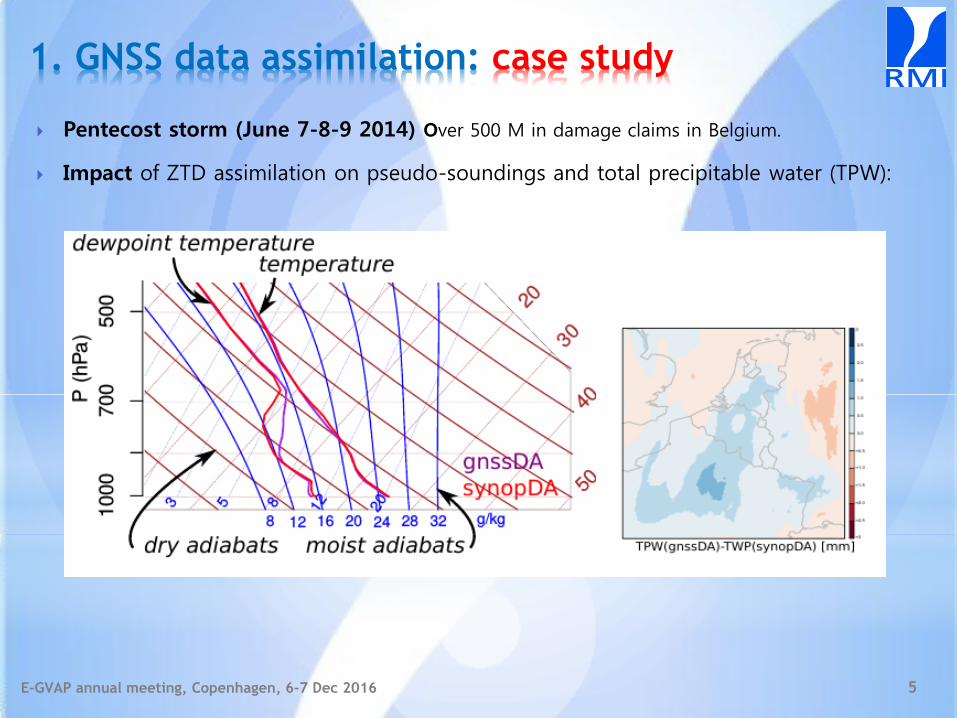
1. GNSS data assimilation: case study
Pentecost storm (June 7-8-9 2014) Over 500 M in damage claims in Belgium.
Impact of ZTD assimilation on pseudo-soundings and total precipitable water (TPW):
6 E-GVAP annual meeting, Copenhagen, 6-7 Dec 2016
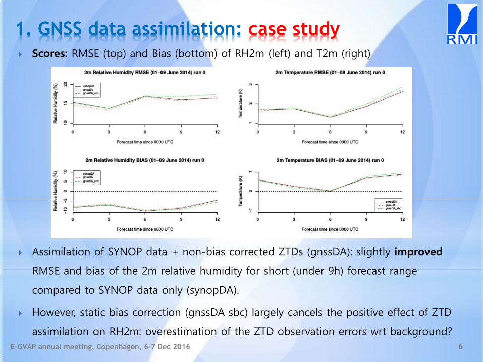
1. GNSS data assimilation: case study
Scores: RMSE (top) and Bias (bottom) of RH2m (left) and T2m (right)
Assimilation of SYNOP data + non-bias corrected ZTDs (gnssDA): slightly improved
RMSE and bias of the 2m relative humidity for short (under 9h) forecast range
compared to SYNOP data only (synopDA).
However, static bias correction (gnssDA sbc) largely cancels the positive effect of ZTD
assimilation on RH2m: overestimation of the ZTD observation errors wrt background?

7 E-GVAP annual meeting, Copenhagen, 6-7 Dec 2016
2. IWV intercomparison activities (PAST)
IWV techniques intercomparison at 28 sites world-wide (NH)
IGS CIMEL radiosondes GOMESCIA AIRS
Van Malderen, R., Brenot, H., Pottiaux, E., Beirle, S., Hermans, C., De Mazière, M., Wagner, T., De Backer, H., and Bruyninx, C.: A multi-site intercomparison of integrated water vapour observations for climate change analysis, Atmos. Meas. Tech., 7, 2487-2512, doi:10.5194/amt-7-2487-2014, 2014.
8 E-GVAP annual meeting, Copenhagen, 6-7 Dec 2016
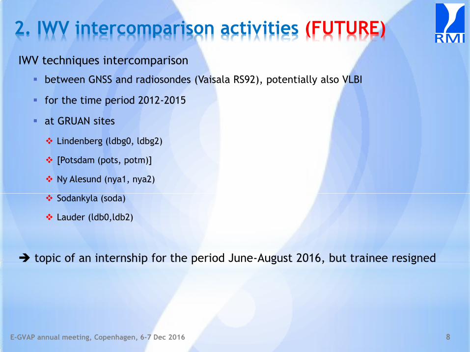
2. IWV intercomparison activities (FUTURE)
IWV techniques intercomparison
between GNSS and radiosondes (Vaisala RS92), potentially also VLBI
for the time period 2012-2015
at GRUAN sites
Lindenberg (ldbg0, ldbg2)
[Potsdam (pots, potm)]
Ny Alesund (nya1, nya2)
Sodankyla (soda)
Lauder (ldb0,ldb2)
topic of an internship for the period June-August 2016, but trainee resigned
9 E-GVAP annual meeting, Copenhagen, 6-7 Dec 2016
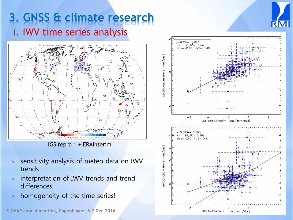
3. GNSS & climate research
i. IWV time series analysis
sensitivity analysis of meteo data on IWV trends
interpretation of IWV trends and trend differences
homogeneity of the time series!
IGS repro 1 + ERAinterim
10 E-GVAP annual meeting, Copenhagen, 6-7 Dec 2016
3. GNSS & climate research
i. IWV time series analysis: homogenization
sub-WG activity in GNSS4SWEC on homogenization of GNSS IWV time series
2 dedicated workshops: 26-27 April 2016 @ Brussels & 23-25 Jan 2017 @ Warsaw
first focus on IGS repro 1
Status
6 different groups applied their homogenization tools on reference IGS repro 1, taken
ERAinterim IWV as reference dataset
generation of synthetic datasets (for IGS repro 1, for IGS repro 1 - ERAinterim
differences) with known offsets and different stochastic behaviour to test tools
against truth
goal: homogenized reference IGS repro 1, to be used by community for climate
studies.
future: homogenization of EPN repro 2 + IAG JWG 4.3.3 “GNSS tropospheric products
for Climate” (chaired by R. Pacione & E. Pottiaux)
11 E-GVAP annual meeting, Copenhagen, 6-7 Dec 2016
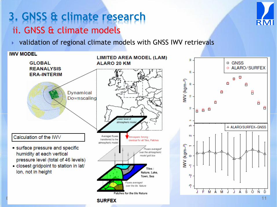
3. GNSS & climate research
ii. GNSS & climate models
validation of regional climate models with GNSS IWV retrievals

12 E-GVAP annual meeting, Copenhagen, 6-7 Dec 2016
3. GNSS & climate research
ii. GNSS & climate models: CORDEX.be
RMI is PI of the CORDEX.be project (“Combining Regional climate Downscaling Expertise
in Belgium”)
provides a frame to combine existing, ongoing efforts in the Belgian climate community,
to optimally bring CORDEX scale information to the Belgian local scales in a coherent
way: a stakeholder should get the same information from any of the 9 partners
GNSS data is used for the validation of the climate model based IWV dataset
(details: talk by E. Pottiaux)
13 E-GVAP annual meeting, Copenhagen, 6-7 Dec 2016
3. GNSS & climate research
ii. GNSS & climate models: SCIENCE4CS
RMI is a member of the consortium SCIENCE4CS for the ERA4CS call (“European Research
Area for Climate Services”)
SCIENCE4CS will provide decision-relevant kilometer-scale climate information through a
new generation of comprehensive climate models and innovative analyses:
1. SCIENCE4CS will employ convection-resolving Regional Climate Models (RCMs), Empirical
Statistical Downscaling (ESD)methods and combined approaches in powerful new ways.
2. these models will be evaluated via newly designed experiments over regions with high quality
observational data of very high spatial resolution
3. a practical, solutions-oriented and user-friendly interface will be developed which will go well
beyond data provision to also include relevant sectorial guidance, best practices and data
processing functionality
GNSS input (in collaboration with IGN): new data sets of homogeneously reprocessed
ground-based observations of Zenith Total Delays (ZTD) and Integrated Water Vapour
(IWV) over Europe obtained from GNSS networks at high spatial resolution
processing, screening, homogenizing, and applying quality control tests to the GNSS
data, and creating gridded ZTD/IWV products and IWV trends and variability indices
adapted to the evaluation of RCM simulations.

14 E-GVAP annual meeting, Copenhagen, 6-7 Dec 2016
3. GNSS & climate research
ii. GNSS & climate models
assess intense precipitation extremes under climate change
CC = Clausius Clapeyron
= saturated water vapour pressure changes 7% per 1°C warming
15 E-GVAP annual meeting, Copenhagen, 6-7 Dec 2016
3. GNSS & climate research
ii. GNSS & climate models
assess intense precipitation extremes under climate change
role of GNSS:
use the Belgian dense network for a statistical validation (distribution-wise & one-to-
one comparison) of the IWV fields of different climate models (and different
resolutions/parameterizations)
study CC for IWV vs. temperature

16 E-GVAP annual meeting, Copenhagen, 6-7 Dec 2016
4. Conclusions
RMI is especially a user of GNSS ground-based data.
The focus of our institute is especially on the climate applications of GNSS data
(validation of climate models, homogenization of time series for long-term
variability studies, etc.).
RMI is well aware of the added value of GNSS data assimilation, but resources
are lacking to take the necessary steps to make this operational.
The use of GNSS data for nowcasting (INCA.be, Integrated Nowcasting through
Comprehensive Analysis) is absent at RMI.