Embed Size (px)
Citation preview
. . . . .
.. . . .
. . . . . . . . . .
September 2005
Rockdale County PS&E Department
Stormwater Utility
Credit Manual
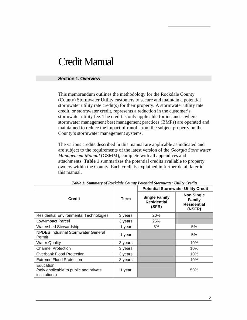
Credit Manual Section 1. Overview
This memorandum outlines the methodology for the Rockdale County (County) Stormwater Utility customers to secure and maintain a potential stormwater utility rate credit(s) for their property. A stormwater utility rate credit, or stormwater credit, represents a reduction in the customer’s stormwater utility fee. The credit is only applicable for instances where stormwater management best management practices (BMPs) are operated and maintained to reduce the impact of runoff from the subject property on the County’s stormwater management systems. The various credits described in this manual are applicable as indicated and are subject to the requirements of the latest version of the Georgia Stormwater Management Manual (GSMM), complete with all appendices and attachments. Table 1 summarizes the potential credits available to property owners within the County. Each credit is explained in further detail later in this manual.
Table 1: Summary of Rockdale County Potential Stormwater Utility Credits Potential Stormwater Utility Credit
Credit Term Single Family Residential
(SFR)
Non Single Family
Residential (NSFR)
Residential Environmental Technologies 3 years 20% Low-Impact Parcel 3 years 25% Watershed Stewardship 1 year 5% 5% NPDES Industrial Stormwater General Permit 1 year 5%
Water Quality 3 years 10% Channel Protection 3 years 10% Overbank Flood Protection 3 years 10% Extreme Flood Protection 3 years 10% Education (only applicable to public and private institutions)
1 year 50%
2
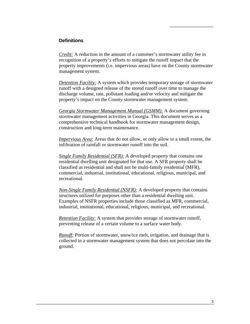
Definitions Credit: A reduction in the amount of a customer’s stormwater utility fee in recognition of a property’s efforts to mitigate the runoff impact that the property improvements (i.e. impervious areas) have on the County stormwater management system. Detention Facility: A system which provides temporary storage of stormwater runoff with a designed release of the stored runoff over time to manage the discharge volume, rate, pollutant loading and/or velocity and mitigate the property’s impact on the County stormwater management system. Georgia Stormwater Management Manual (GSMM): A document governing stormwater management activities in Georgia. This document serves as a comprehensive technical handbook for stormwater management design, construction and long-term maintenance. Impervious Area: Areas that do not allow, or only allow to a small extent, the infiltration of rainfall or stormwater runoff into the soil. Single Family Residential (SFR): A developed property that contains one residential dwelling unit designated for that use. A SFR property shall be classified as residential and shall not be multi-family residential (MFR), commercial, industrial, institutional, educational, religious, municipal, and recreational. Non-Single Family Residential (NSFR): A developed property that contains structures utilized for purposes other than a residential dwelling unit. Examples of NSFR properties include those classified as MFR, commercial, industrial, institutional, educational, religious, municipal, and recreational. Retention Facility: A system that provides storage of stormwater runoff, preventing release of a certain volume to a surface water body. Runoff: Portion of stormwater, snow/ice melt, irrigation, and drainage that is collected in a stormwater management system that does not percolate into the ground.
3
General Policies The following general policies apply when considering stormwater credits: • Credits are only applied to eligible property owners. Since the stormwater
fee is being assessed on an individual parcel basis, a group of property owners, typically represented as a homeowner association, cannot apply for a credit. An eligible property owner is defined as a property that contributes runoff to the qualifying stormwater BMP via natural and/or manmade conveyance systems.
• A residential homeowner’s association (HOA) which has it’s own properly designed, constructed, and maintained stormwater BMP should contact the County Stormwater Manager to determine if a credit can be provided. Any resulting credit awarded will be divided among eligible property owners within the HOA.
• Applications for a stormwater credit for existing facilities may be submitted to Rockdale County at any time. Credits awarded will be applied to the next billing cycle.
• Applications for a stormwater credit for new construction may be submitted once the BMP is in place or when the stormwater utility rate is applied, whichever is later.
• The County will undertake periodic visual inspections of the BMP’s being utilized to obtain a credit. Consequently, a Right-of-Entry or an easement must be granted to the County for credits to be approved.
• The credits available for SFR and NSFR properties are described later in this report.
• The term of the credit varies based upon the type credit. See Table 1 for credit terms. During the credit term, the County will conduct random inspections such that each credit could potentially be inspected. If the BMP facility is found to be functional and being properly maintained, the credit will remain in effect. Likewise, if the BMP facility is not functional or is not being maintained, the credit will be voided on the next billing cycle. Before a credit is re-instated, the property owner will have to reapply for the credit as outlined in this manual.
Basic Procedures
Most of the credits in this manual require an application, and some of the credit applications require engineering calculations to verify eligibility to receive a credit. The credits associated with engineering calculations are
4
identified in the manual and the credit application forms. The County requires that these calculations be performed, signed, and sealed in accordance with the professional certification provisions outlined in the County’s Land Development Ordinances. The procedure for filing a credit application includes the following tasks: • Obtain an application packet from the County. • If required by the credit, retain a landscape architect or professional
engineer to perform the required analysis. • Submit the completed application with all sections appropriately filled out
and all required information contained within or attached to the application.
• The County will review and rule on the eligibility of the credit application. The decision by the County is final.
• If the credit application is approved, the County will put the stormwater credit into affect with the next billing cycle.
• During the credit term, the County has the right to inspect the BMP facility to insure it is functioning per the design documents and is being properly maintained.
• At the end of the credit term, the credit will automatically expire. It is the property owner’s responsibility to insure that an application is made prior to the credit expiring. Reapplication must be made to receive a credit. A new credit application is required at the end of the credit term.
• When credits are awarded for SFR customers, they will be applied to the next billing cycle. Since SFR properties are being billed annually, the credit will be posted and reflected in the next annual bill. For NSFR properties, they are being billed monthly, and the credit will be applied the month following approval. The anticipated SFR billing cycle will be each August 1 and credit applications must be received by May 1 and approved before July 1 to be considered.
Design and Implementation Any stormwater management system within the County must follow the recommendations and guidelines presented in the GSMM as well as the County’s Land Development Ordinance. This document can be found on the Internet by using the following link: http://www.georgiastormwater.org/. This document discusses stormwater management planning and design, unified stormwater sizing criteria, and specific BMP controls achieving various levels
5
of treatment. The unified stormwater sizing criteria accounts for varying levels of treatment provided for calculating BMP effectiveness.
Section 2. Credit Policies and Procedures
This section of the report explains the procedures involved in applying for a stormwater credit. The procedures include step-by-step instructions and eligibility requirements for obtaining the stormwater utility credit.
Single Family Residential (SFR) The stormwater credits SFR property owners are eligible to apply for are listed below. Each credit is explained in more detail in the pages that follow. • Residential Environmental Technology • Low-Impact Site • Watershed Stewardship
The SFR property owner shall follow the credit application procedures outlined herein for each credit.
Residential Environmental Technology
Overview As the public is becoming more aware of stormwater management and “better site design” development, the number of BMPs being developed for residential properties is increasing. From rain barrels, cisterns, rain gardens, and infiltration areas; all of these have a place in a local stormwater management program. The County wishes to encourage these types of practices. The effectiveness of these types of BMPs is very site specific. Rather than take a ‘one size fits all’ approach, it would be better for the individual property owner to determine what kinds of BMPs they desire, and work with the County Stormwater Manager to implement it. Consequently, depending upon the effectiveness, a credit is available for properly design, constructed and maintained residential BMPs. In each case, the County will be using the GSMM standards to evaluate the BMP and its eligibility.
6
Stormwater Credit Application Procedures The SFR property owner shall follow the procedures below when applying for a stormwater credit for a cistern:
STEP 1: Obtain a credit application packet from the County.
STEP 2: The property owner shall identify the BMP being utilized and insure it is designed, maintained, and operated in accordance with general stormwater management requirements listed in the GSMM.
STEP 3: The property owner shall submit the credit application to the County.
The property owner shall continue to maintain the BMP during the full credit term. Renewal of the stormwater utility credit shall be in accordance with the Basic Procedures section of this manual.
Low-Impact Parcel
Overview There are several areas in the County where parcels are relatively large and the amount of impervious area, in comparison to the total lot size, is relatively small. These parcels have a resulting impact whereby there is a reduction of runoff impacts since most of the parcel is in an undeveloped or low impact condition.
Parcel Description A credit shall apply to those SFR property owners who can prove that their lots comply with the “low-impact” development provisions presented herein. This shall be achieved through the use of large lot SFR parcels and natural area conservation. Typical characteristics that shall apply are included in Table 2:
Table 2: Stormwater Utility Credit Requirements for Low-Impact Parcels Parameter Requirement
Impervious Cover1 (%) Must be less than 2.3% Total Site Area (Acres) Must be greater than 6 acres
1. Impervious cover of 2.3% is from the average of the percent impervious cover determined for the Big Haynes Creek watershed SFR parcels.
7
Each SFR property owner that wishes to apply for this credit shall be responsible for calculating the total site area, impervious surface area, and natural conservation area. Utilize the following procedures:
• Determine the total area of the SFR parcel. This must be a minimum of 6 acres.
• Determine the impervious area for the SFR parcel. The impervious area shall include the structure, driveway, sidewalk (do not include the sidewalk in front of the house next to the street), pool, pool deck, patio, shed, or any other accessory impervious area. The impervious surface must be less than 2.3% of the total (pervious area plus impervious surface) area of the parcel.
• If the SRF parcel meets all the requirements above, they will be eligible for a stormwater utility rate credit of 25%.
Stormwater Credit Application Procedures The SFR property owner shall follow the procedures below when applying for a stormwater credit for site design:
STEP 1: Obtain a credit application packet from the County.
STEP 2: The property owner shall provide a copy of the information where the property owner obtained total parcel area and total impervious area. Total impervious area shall be detailed to include which portion pertains to the structure, driveway, sidewalk, and other accessory areas.
STEP 3: The property owner shall submit the credit application, complete with the relevant documentation and calculations, to the County.
Upon receipt of the credit application, the County shall review the documentation and calculations. Upon verification, the stormwater credit will be applied, starting with the next billing cycle. If the County inspector does not approve of the customer’s application for a stormwater utility credit under the low-impact criteria, the County will send a letter to the property owner explaining why the credit application was not approved. Renewal of the stormwater utility credit shall be in accordance with the Basic Procedures section of this manual and the requirements listed above. A 25% credit is available for the Low-Impact Parcel credit.
8

Watershed Stewardship
Overview SFR and NSFR property owners are eligible for a stormwater credit if, at a minimum, the property owner participates in a local watershed stewardship event. Events are set up, organized, and executed through a partnership with citizens, local groups, municipalities, and federal agencies. The County has identified two watershed stewardship BMPs in their National Pollutant Discharge Elimination System (NPDES) Permit Notice of Intent (NOI) to the Georgia Department of Natural Resources (DNR) Environmental Protection Division (EPD).
Watershed Stewardship Description The two BMPs listed in the NOI include the storm drain stenciling program and community stream clean-ups. Storm drain stenciling includes stenciling “NO DUMPING/LEADS TO STREAM” on catch basins and distributing fish-shaped door hangers with information on non-point source pollution in these stenciling areas. The community stream clean-ups will coordinate with organizations (such as Rivers Alive and the Great American Clean-Up Campaign) for stream clean-ups that may include, but not be limited to, Almand Branch, Big Haynes Creek, Boar Tusk Creek, Honey Creek, McClain Branch, South River, Yellow River, Little Haynes Creek, and Randy Poynter Lake. The County shall provide a schedule of Watershed Stewardship Program event dates and locations. Each SFR and NSFR property owner shall be responsible for reserving space for participation in each event by contacting the County Stormwater Manager. The County shall have a maximum enrollment for each event and try to assign participation roles in a manner that fosters equal opportunity. Several events shall be scheduled throughout the year, subject to County staffing resources. However, the County is not required to schedule events to match demand from SFR and NSFR property owners. There shall only be one stormwater credit certificate issued per SFR and NSFR property. Participation may include more than one person. However, the certificate may only be issued for those properties where the property owner or adult over the age of 18 responsible for paying rent or mortgage is one of the participants. It is the property owner’s responsibility to maintain the location of the certificate and to provide this certificate upon payment of the stormwater utility fee. Certificates shall be issued for a minimum of eight (8) hours of participation in one or both of the BMPs listed above. No
9
replacement certificates shall be issued for those lost or misplaced. Participation by community/civic organizations shall be promoted by allowing credits to be transferable from one property owner to another.
Stormwater Credit Application Procedures The SFR and NSFR property owner shall follow the procedures below when applying for a stormwater credit for watershed stewardship:
STEP 1: Obtain a credit application packet from the County.
STEP 2: The property owner shall insure that the attendance certificate for the Rockdale County Watershed Stewardship Program. Attendance at City of Conyers events is not transferable to Rockdale County’s stormwater utility.
STEP 3: The property owner shall submit the credit application, complete with the relevant certificate, to the County. Upon receipt of the credit application, the County shall review the certificate with the event and the participation roster. Upon verification, the stormwater credit will be applied to the next billing cycle...
If the County inspector does not approve of the certificate being utilized for the watershed stewardship stormwater utility credit, the County will send a letter to the property owner explaining why the credit application was not approved. If the property owner reapplies and the verification results in an approval of the application, the County will notify the property owner of the credit amount and the date the credit will become effective. The property owner shall continue to participate in the stewardship events annually to receive a certificate. Renewal of the stormwater utility credit shall be in accordance with the Basic Procedures section of this manual and the requirements listed above. A 5% credit is available for watershed stewardship.
Non-Single Family Residential (NSFR) In addition to the Watershed Stewardship credit explained above, NSFR property owners are eligible to apply for the credits listed below. Each credit is explained in more detail in the pages that follow. • Educational Institutions • NPDES Industrial Stormwater General Permit Compliance • Management of the Water Quality Volume
10

• Management of the Channel Protection Volume • Management of the Overbank Flood Protection Volume • Management of the Extreme Flood Protection Volume The last four credits listed above are part of the Unified Sizing Criteria discussed in the GSMM. These four credits will be discussed as a group under the Unified Sizing Criteria heading.
Education Institutions It is the goal of Rockdale County to strongly and financially encourage both public and private educational systems (grades 1-12 inclusive), to educate and inform their students on the importance of surface water, ground water and stormwater resource, and how they can play a role in preserving and restoring the physical, chemical, and biological integrity of the County’s water resources. Consequently, the owner of property which is used as a site for a public or private school and which agrees to teach a general environmental science curriculum that includes water protection measures at the primary or secondary level may receive a credit against the stormwater service charge applicable.
Eligibility The Educational Credit shall be available to all public or private educational systems in grades one (1) through twelve (12) inclusive, which teach as part of their official curriculum, the WaterWiseTM program, Enviroscape Program, GLOBE (Global Learning and Observation to Benefit the Environment) Program, Project WET, or another such program approved by the County Stormwater Manager. • The credit shall not be available to individual residences. • The credit shall not be available to educational institutions, which have
less than one thousand (1,000) full-time students enrolled in the systems. • No other curriculum shall be eligible for such credit unless granted by the
Board of County Commissioners. • The credit shall not be retroactive, but shall be applied beginning the next
billing cycle and thereafter as applicable.
Amount of Credit The educational credit may be up to 50 percent of the service charge applicable to a school property. Educational credits may be taken in conjunction with any other credit available under this section. The amount of
11
credits given shall be as determined by the County Stormwater Manager based on the number of contact hours and the curriculum being taught. The educational credit may be taken in addition to any other credit available under this section. Systems do not need to offer the curriculum during the summer to obtain a 12-month credit. In no case should the credit exceed fifty percent (50%) of the total stormwater user fee.
Application Procedure Prior to July 1 of each year, the superintendent of the Rockdale County School System or in the case of private schools the chief executive officer of the school, shall certify to the County Stormwater Manager, the water protection measures curriculum being taught in each school for which an educational credit is being claimed and the extent to which such curriculum is being taught. For purposes of this educational credit a public school shall be any school operated by the Rockdale County School District and a private school shall be a school operated by a private entity teaching some or all of the grades K through 12 at which are taught subject[s] commonly taught in the public schools operated by the Rockdale County School District. The following additional information should be provided to help assess the credit allowance. • Address of site (property) and point of contact. • Approximate number of total students per grade and total school
enrollment at the site(s). • Approximate number per grade that will take the curriculum.
NPDES Industrial Stormwater General Permit Compliance By complying with NPDES Industrial Stormwater General Permit requirements for industrial facilities, NSFR property owners are helping the County address potential water quality issues on site before they are discharged into the public drainage system and/or Waters of the State. Therefore, these properties are eligible for a stormwater utility credit. If the NSFR property owner has properly secured coverage under the NPDES Industrial Stormwater General Permit, and is in compliance with all applicable requirements (i.e. development and implementation of a Stormwater Pollution Prevention Plan (SWPPP)), a credit application may be filed with the County.
12

Credit Requirements The following requirements will apply for NSFR property owners who qualify for an NPDES Industrial Stormwater General Permit stormwater utility credit: • NSFR properties that operate under compliance with their NPDES
Industrial Stormwater General Permit are eligible for a credit in their stormwater utility fee. The credit shall only be applied to that portion of the property covered by the permit.
• It is the property owner’s responsibility to obtain a credit application from the County. The property owner shall complete the application, attaching any required documents verifying compliance with the NPDES Industrial Stormwater General Permit. At a minimum, the documentation attached to the credit application shall include the following: − Address of site and point of contact − Copy of the current Notice of Intent (NOI) − Copy of a summary annual report of compliance − Copy of the SWPPP − Certification by the responsible party/permit holder that the SWPPP is
being implemented • Once complete, the application shall be turned into the County. • Upon approval, the credit will be applied starting the year following
approval. The maximum credit amount available for NPDES Industrial Stormwater General Permit compliance is 5%.
• The NSFR property owner shall continue to send a copy of an annual summary report of compliance to the County Stormwater Manager and continue to comply with their NPDES Industrial Stormwater General Permit requirements. The property owner will be responsible for sending the annual report to the County. Failure to do so will nullify the stormwater utility fee credit.
13

Unified Stormwater Sizing Criteria The four treatment levels of the unified stormwater sizing criteria include water quality, channel protection, overbank flood protection, and extreme flood protection. Table 3 presents each treatment level with a description of each, as provided in the GSMM.
Table 3: Unified Stormwater Sizing Criteria
Treatment Level Maximum Available
Credit Description1
Water Quality 10%
Treat the runoff from 85% of the storms that occur in an average year. Per the GSMM, this equates to providing water quality treatment for the runoff resulting from a rainfall depth of 1.2 inches. Reduce average annual post-development TSS loadings by 80%.
Channel Protection 10%
Provide extended detention of the 1-year storm event released over a period of 24 hours to reduce bankfull flows and protect downstream channels from erosive velocities and unstable conditions.
Overbank Flood Protection 10%
Provide peak discharge control of the 25-year storm event such that the post-development peak rate does not exceed the predevelopment rate to reduce overbank flooding.
Extreme Flood Protection 10%
Evaluate the effects of the 100-year storm on the stormwater management system, adjacent property, and downstream facilities and property. Manage the impacts of the extreme storm event through detention controls and/or floodplain management.
1) Description of each treatment level is as published in Chapter 1.3 of the GSMM (August 2001).
The various options available for providing the desired level of treatment can be found in the GSMM. Volume 2, Chapter 1.3 provides an overall comparison of BMP options as they apply to the four levels of the unified stormwater sizing criteria. Volume 2, Chapter 3 provides more detailed information on each BMP. Design examples for a select number of BMPs are provided in Volume 2, Appendix D.
14

NOTE: All work associated with pursuit of a stormwater utility fee credit shall be done in strict accordance with the County’s current ordinances related to the management of stormwater runoff.
Credit Applications Credit applications are required for most of the credits included in this manual. Appendix A provides the credit application forms for the applicable credits described in this manual. Appendix B contains miscellaneous forms required as part of the stormwater utility credit application process, including a Right-of-Entry form and a County inspection form.
15


APPENDIX A
A-1: NPDES Industrial Stormwater General Permit Credit Application Form
A-2: Credit Application Form

Appendix A-1
NPDES Industrial Stormwater General Permit Credit Application Form

ROCKDALE COUNTY NPDES Industrial Stormwater General Permit Credit Application/Renewal Form Instructions:
Fill out this form completely. A separate application must be made for each separate property location. One application must be submitted for each separate NPDES Industrial Stormwater General Permit. Please insure all NPDES permitted facilities are in a proper state of repair and maintained. Fill out and attach the following:
• NPDES permit • Previous year’s annual report • Copy of the Stormwater Pollution Prevention Plan (SWPPP)
Mail the completed form, annual report, NPDES permit, and SWPPP to:
Rockdale County Attn: County Stormwater Manager 958 Milstead Avenue Conyers, GA 30012
Parcel Identification Number:
Property Owner Name:
Property Address:
Property City/Zip Code:
Property Owner E-mail Address:
Property Owner Phone/Fax Number:
Mailing Address:
I hereby request Rockdale County to review this application for a stormwater service fee credit. I certify that I have authority to make such a request and grant such authority for this property. The attached information is true and correct to the best of my knowledge and belief. (This form must be signed by the financially responsible person if an individual, or if not an individual by an officer, director, partner, or registered agent with authority to execute instruments for the financially responsible person). I agree to provide corrected information should there be any change in the information provided herein.
Type or print name Title or Authority Signature Date

Appendix A-2
Credit Application Form

ROCKDALE COUNTY Credit Application Form Instructions:
Fill out this form completely. One application must be submitted for each separate property location. Multiple stormwater controls may be included in the application for a single property location. Please insure all stormwater management facilities are in a proper state of repair and maintained. Attach all appropriate documentation to support this request. Documentation shall include:
1. Site plan with stormwater facilities and contributory drainage area. 2. Description of stormwater facilities. 3. Appropriate pages from Volume 2 of the Georgia Stormwater Management Manual (August 2001, or as
amended) identifying design requirements for each on-site stormwater control. 4. Documentation that facilities meet one or more criteria for the fee credit (technical report). 5. Seal by professional engineer licensed in Georgia (does not apply to residential credits, educational credit,
or Watershed Stewardship).
Fill out and attach a Right-of-Entry Form. Mail the completed form (with attachments), and Right-of-Entry to:
Rockdale County Attn: County Stormwater Manager 958 Milstead Avenue Conyers, GA 30012
Place a check next to the credit being applied for with this application:
Type Credit Applicability/Requirements Residential Environmental Technology SRF property Low Impact Parcel SRF property Watershed Stewardship SRF or NSFR property Educational Institution Public & Private schools grades 1-12 Water Quality NSFR property - requires PE certification Channel Protection NSFR property - requires PE certification Overbank Flood Protection NSFR property - requires PE certification Extreme Flood Protection NSFR property - requires PE certification
General Information:
Owner Name:
Owner Mailing Address:
Owner Mailing City/Zip:
Contact Phone/Fax Number:
Contact E-mail Address:
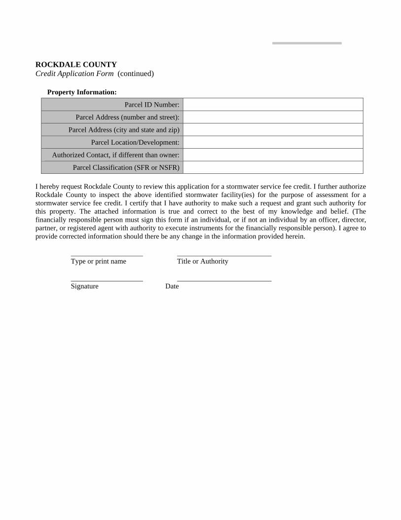
ROCKDALE COUNTY Credit Application Form (continued)
Property Information:
Parcel ID Number:
Parcel Address (number and street):
Parcel Address (city and state and zip)
Parcel Location/Development:
Authorized Contact, if different than owner:
Parcel Classification (SFR or NSFR)
I hereby request Rockdale County to review this application for a stormwater service fee credit. I further authorize Rockdale County to inspect the above identified stormwater facility(ies) for the purpose of assessment for a stormwater service fee credit. I certify that I have authority to make such a request and grant such authority for this property. The attached information is true and correct to the best of my knowledge and belief. (The financially responsible person must sign this form if an individual, or if not an individual by an officer, director, partner, or registered agent with authority to execute instruments for the financially responsible person). I agree to provide corrected information should there be any change in the information provided herein.
Type or print name Title or Authority Signature Date

APPENDIX B
B-1: Right-of-Entry Form B-2: Inspector Checklist for Stormwater Facility Inspection

Appendix B-1
Right-of-Entry Form

ROCKDALE COUNTY Right-of-Entry Hereinafter termed “Owner” and ROCKDALE COUNTY, hereinafter termed "County" in consideration of the mutual promises of the Owner and County hereinafter contained, agree upon the following terms for the entry of the County and its representatives as set forth herein upon the real estate hereinafter described:
“Owner” hereby grants to County, its employees, agents, consulting engineers, contractors and other representatives the right to enter upon the above described real estate on and after, , for the purpose of inspecting on-site stormwater controls which work shall be completed strictly in accordance with the standard practice of engineering. The County shall, as soon as practicable after completion of the work as above described, cause all affected property of the Owner to be restored to its original condition as nearly as reasonably possible. “Owner” hereby covenants with County that he/she is/they are the true and lawful owner of the above described real estate and has/have lawfully seized of the same in fee simple and has/have the right and full power to grant this right of entry, which right of entry shall cease to be effective on completion of the above described inspection. “Owner” will not charge County rent or other compensation during the period of time County occupies the said real estate for purposes aforesaid under the provisions of this right of entry. IN WITNESS WHEREOF, the parties have caused their respective names to be signed hereto on the day of , 20 . OWNER REPRESENTATIVE OF ROCKALE COUNTY

Appendix B-2
Inspector Checklist for Stormwater Facility Inspection

ROCKDALE COUNTY Inspector's Checklist for Stormwater Facility Inspection Instructions to Inspector:
• Make contact with the authorized contact from Credit Application Form and notify of and coordinate site
inspection. Authorized contact or owner need not be present for site inspection though inspector should make every effort to accommodate authorized contact's availability to accompany inspector.
• Fill out the form completely only if the facility is in proper state of maintenance and repair. If not in proper repair and maintenance fill out only the "General Information" and "Maintenance and Repair" sections and return to the County Stormwater Manager.
• If site plans were supplied by engineering and all dimensions and necessary site improvement details can be checked against the plans, then only deviations from the plans should be noted and annotated in red pen on the plans. If plans are used, check the blocks in the "Facility" and "Drainage Area" sections.
• If site plans are not available or not used fill out all sections fully. • Attach Credit Application Form and return to the County Stormwater Manager.
General Information
Inspector’s Name: Date Inspected:
Maintenance and Repair:
Description YES NO1
Is facility compliant with Georgia Stormwater Management Manual?
Is facility clear of sediment deposits or debris that significantly reduce operating ability or capacity?
Is facility in good repair to allow proper function?
Is the facility emergency overflow (if applicable) in proper repair and not eroded?
Comments on "NO" check marks:
(1) Note: A "NO" check will void the credit application. When the condition is remedied, a new application may be submitted.
ROCKDALE COUNTY Inspector's Checklist for Stormwater Facility Inspection (continued)
Site Plan Available? Yes No
[Check block to refer reviewer to County supplied site plan. If all necessary information is not supplied on the site plan give additional information here.] Facility Dimensions and Layout (provide sketch with dimensions): Note: Outlet information, if applicable, must be sufficient to develop a rating curve for the facility.
Facility Ancillary Device Layout (provide sketch with approximate dimensions):
Note: Dimensions and sketch must be sufficient to calculate volume of storage area (if applicable) from lowest outlet elevation to top of overflow point.