Embed Size (px)
Citation preview
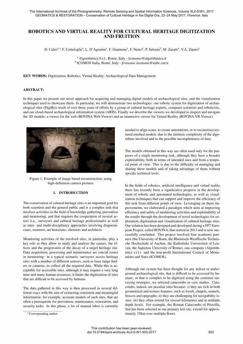
ROBOTICS AND VIRTUAL REALITY FOR CULTURAL HERITAGE DIGITIZATIONAND FRUITION
D. Calisia,∗, F. Cottefogliea, L. D’Agostinia, F. Giannonea, F. Nencia, P. Saloniab, M. Zarattia, V.A. Ziparoa
a Algorithmica S.r.l., Rome, Italy - [email protected] ICOMOS Italia, Rome, Italy - [email protected]
KEY WORDS: Digitization, Robotics, Virtual Reality, Archaeological Data Management
ABSTRACT:
In this paper we present our novel approach for acquiring and managing digital models of archaeological sites, and the visualizationtechniques used to showcase them. In particular, we will demonstrate two technologies: our robotic system for digitization of archae-ological sites (DigiRo) result of over three years of efforts by a group of cultural heritage experts, computer scientists and roboticists,and our cloud-based archaeological information system (ARIS). Finally we describe the viewers we developed to inspect and navigatethe 3D models: a viewer for the web (ROVINA Web Viewer) and an immersive viewer for Virtual Reality (ROVINA VR Viewer).
Figure 1. Example of image based reconstruction, usinghigh-definition camera pictures
1. INTRODUCTION
The conservation of cultural heritage sites is an important goal forboth scientists and the general public and is a complex task thatinvolves activities in the field of knowledge gathering, preventionand monitoring, and that requires the cooperation of several ac-tors (i.e., surveyors and cultural heritage professionals) as wellas inter- and multi-disciplinary approaches involving diagnosti-cians, restorers, art historians, chemists and architects.
Monitoring activities of the involved sites, in particular, play akey role as they allow to study and analyze the causes, the ef-fects and the progression of the decay of a target heritage site.Data acquisition, processing and maintenance are crucial issuesin monitoring: in a typical scenario, surveyors access heritagesites with a number of different sensors, such as laser range find-ers or cameras, to collect all the required data. While this is ac-ceptable for accessible sites, although it may require a very longtime and many human resources, it limits the digitization of sitesthat are difficult to be accessed by humans.
The data gathered in this way is then processed in several dif-ferent ways with the aim of extracting consistent and meaningfulinformation: for example, accurate models of such sites, that areoften a prerequisite for prevention, maintenance, restoration, andsecurity tasks. In this phase, a lot of manual labor is currently
∗Corresponding author
needed to align scans, to create annotations, or to reconstruct tex-tured meshed models, due to the intrinsic complexity of the algo-rithms involved and to the possible incompleteness of data.
The models obtained in this way are often used only for the pur-poses of a single monitoring task, although they have a broaderexploitability, both in terms of intended uses and from a tempo-ral point of view. This is due to the difficulty of managing andsharing these models and of taking advantage of them withoutspecific technical tools.
In the fields of robotics, artificial intelligence and virtual realitythere has recently been a significative progress in the develop-ment of robotic and automated technologies, as well as visual-ization techniques that can support and improve the efficiency ofthis task from different points of view. Leveraging on these im-provements, we elaborated a paradigm which aims at improvingefficiency and safety of monitoring activities and exploitability ofthe results through the development of novel technologies for ex-ploration, digitization and visualization of cultural heritage sites.Our solution has been designed and developed during a FP7 Euro-pean Project, called ROVINA, that started in 2013 and is now suc-cessfully concluded. This project involved four academic part-ners (the University of Bonn, the Rheinisch-Westflische Technis-che Hochschule of Aachen, the Katholieke Universiteit of Leu-ven, the Sapienza University of Rome), one company (Algorith-mica s.r.l.) and the non-profit International Council of Monu-ments and Sites (ICOMOS).
Although our system has been thought for any indoor or under-ground archaeological site, that is difficult to be accessed by hu-mans, or that is complex to be digitized using the common sur-veying strategies, we selected catacombs as case studies. Cata-combs, indeed, are peculiar sites because: i) they are rich in bothgeometrical and texture features, such as loculi, chapels, tunnels,frescos and epigraphs; ii) they are challenging for navigability is-sues; iii) they often extend for several kilometres and at multipledepth levels. For example, the Roman Catacombs of Priscilla,that has been selected as our primary test site, extend for approx-imately 15km over multiple floors.
The International Archives of the Photogrammetry, Remote Sensing and Spatial Information Sciences, Volume XLII-5/W1, 2017 GEOMATICS & RESTORATION – Conservation of Cultural Heritage in the Digital Era, 22–24 May 2017, Florence, Italy
This contribution has been peer-reviewed. doi:10.5194/isprs-archives-XLII-5-W1-503-2017 503

2. STATE OF THE ART
Conservation of cultural heritage sites is a practice that encom-passes several disciplines ranging from material theory to struc-tural engineering. Although it is not feasible to provide a com-plete overview of the state of the art, in order to place our sys-tem in context, we will provide a brief introduction to the majoractivities involved in the conservation of cultural heritage sites:measure, documentation, classification, and diagnostics.
Measuring is a key building block of any surveying activity. Thereare two types of measurements: “direct” and “indirect” ones.While direct measurements are performed directly (and manu-ally) by the surveyor on the artefact, indirect measurements, onwhich our system is focused, entail the construction of a digitalmodel of the involved artefact Martinelli (2006) in order to per-form measures on it. Those models are usually obtained throughthe use of laser scanning and/or image analysis: both methodsallow for morphometric surveys Drap et al. (2003).
Laser-based systems are common for architectural conservation Bar-ber et al. (2006) and offer a wide variety of technologies (time-of-flight, phase modulation, optical triangulation, etc.) to adaptto the specific task (e.g., surveying large environments or digi-tizing small artefacts) and accuracy needed. These sensors canbe rather expensive but offer a high precision and direct accessto 3D information Johansson (2002). Image-based systems havebeen shown to provide precisions similar to those of Lidar scan-ners, especially when a sufficient number of images close to thesurfaces can be taken. They have the advantage that image/colordata are available, that are perfectly aligned with the 3D data. Thecaptured data – as for lidars – produces point clouds that needfurther post-processing. Image-based systems usually employhigh-resolution commercial cameras and commercial photogram-metry software or, more recently, self-calibrating structure-from-motion systems Vergauwen and Van Gool (2006); Theo Moonsand Vergauwen (2008) or multi-view stereo approaches. Theseapproaches are lower cost solutions compared to lasers, but canstill provide high quality reconstructions especially for what con-cerns appearance.
Documentation is the goal of many surveys and aims at producingdigital archives of the site under observation. In the realm of cul-tural heritage, documentation activities are performed by publicbodies that, for example, in Italy usually are superintendenciesand ministries. The digital archives can host contents in manydifferent formats, including 3D models that can be either purelygeometric or can also include textures from images. When thesurveys have a purely descriptive documentary purpose, i.e., theyare not intended for measurement or diagnosis, 3D models canhave a lower resolution but they are, in general, more visuallyappealing. Their main goal is to disseminate cultural heritage tobroad audiences, but also support archeological interpretation Be-raldin et al. (2005).
Classification activities are usually tied to documentation tasksand pertain to the categorization of elements of a site into tax-onomies or ontologies with different degrees of complexity. Forexample, in an industrial context it would be interesting to cat-egorize rooms of a plant – and equipment therein – based ontheir functional properties. In a cultural heritage site, architec-tural components are classified on the basis of a number of dif-ferent parameters such as period of construction, used materials,state of conservation: this classification is usually performed by
Figure 2. Example of Table of Deterioration.
human users, who manually tag items and portions of the environ-ment. When data is collected on a geographical scale, the mod-els are generally archived into Geographical Information Systems(GIS). In such a scenario, data can be queried on both geograph-ical and qualitative levels. For example, one may look for “allthe sites built before 1000 B.C. in Italy” or “all the pots made ofceramic from Germany”.
Diagnostics has the goal to collect and analyze the informationabout the state of conservation of the surveyed areas in order toprevent damage or perform restoration. From a practical perspec-tive, the diagnostic activities have the purpose of generating spe-cific deliverables. Examples of such deliverables in the contextof cultural heritage are the Table of Deterioration and the Tableof Materials. The Table of Deterioration is a map showing pos-sible deteriorations such as cracks and mold (see Fig. 2 for anexample). In Italy, the table follows the UNI-NorMal commis-sion standards, that is composed by the Ente Nazionale Italianodi Unificazione (UNI) and the Commissione NORmalizzazioneMAteriali Lapidei (NorMaL). At a European level, the standardsare dictated by CEN (i.e., WS Construction, WS Measurement,WS Material). The Table of Materials instead maps the areas ofthe site under survey to the different materials of which they arecomposed.
3. THE ROVINA PARADIGM
Our project aims at improving the state of the art in measuring,documentation and classification (and thus indirectly supportingdiagnosis activities) through a novel approach to surveying, datamanagement and fruition based on three main components:
• DigiRo, an automated robot for collecting data with high-precision sensors, including laser scanners and cameras;
• ARIS, the cloud-based Archaeological Information System,to manage, share and elaborate data in the form of photo-realistic and metrically precise 3D models of the exploredsites;
• Web and VR Visualizers, that allow to virtually navigatethe 3D models through a very intuitive interface which alsoallows for an immersive experience.
The International Archives of the Photogrammetry, Remote Sensing and Spatial Information Sciences, Volume XLII-5/W1, 2017 GEOMATICS & RESTORATION – Conservation of Cultural Heritage in the Digital Era, 22–24 May 2017, Florence, Italy
This contribution has been peer-reviewed. doi:10.5194/isprs-archives-XLII-5-W1-503-2017
504

(a) Supervisory Interface. (b) Multimodal Interface in the Priscilla Catacombs.
Figure 3. Mission Control interface Early Prototype.
3.1 DigiRo: the digitization robot
While there have been many attempts in the past to use robots toexplore hard-to-access sites (see, e.g., Thrun et al. 2005), DigiRois one of the first platforms specifically conceived for performingmethodological surveys of unknown cultural heritage sites.
DigiRo development has been based on one hand on an iterativedesign process of the robotic platform and on the other hand onthe integration and development of novel algorithms that extendthe current state of the art in autonomous mapping and localiza-tion, 3D reconstruction and on-line analysis. During the last yearof the project the robotic platform went through its third and lastiteration of a continuos process that has been guided by the re-quirements dictated by the analyses of the environments beingexplored: we thus equipped a commercial tracked mobile basewith a sensor suite composed by an inexpensive 3D laser rangefinder, three low-budget RGB-D cameras, an array of 7 high-quality RGB cameras, an inertial measurement unit, battery statusmonitors and thermal/humidity sensors.
In addition, the robot is also equipped with a distributed com-putation system that includes: two laptops, one for running thealgorithms in charge of the autonomous behaviors and anotherfor logging the data coming from the array of cameras. Three in-expensive single-board computers are also on-board, their role isto preprocess sensor data and to interface with the other hardwarecomponents of the robot.
In order to allow DigiRo to survey archaeological sites in an au-tonomous or semi-autonomous way, several challenges had to beaddressed, and dedicated computer vision and robotics solutionshave been developed. At the core of the platform intelligencethere is the capability of simultaneously building a 3D map ofthe environment and localizing within this map (SLAM). DigiRoSLAM module extended different so-far state-of-the-art compo-nents such as g2o Kuemmerle et al. (2011), DCS Agarwal etal. (2014) and a variant of ICP Serafin and Grisetti (2015), thusobtaining a novel 3D localization and mapping approach. Com-pared to most existing SLAM methods, DigiRo SLAM modulebuilds 3D maps in real-time during the survey allowing the robotto act autonomously and enabling its own decision-making basedon the environment explored so far. A considerable effort hasbeen devoted in making the approach more robust and devel-oping an extension of DCS, originally proposed by Agarwal etal. Agarwal et al. (2014), to assessing the degree of consistencyof maps Mazuran et al. (2014) and to automatically calibrating
the sensors (see also Basso et al. 2014; Tedaldi et al. 2014). Inorder to safely navigate in the environment, the robot uses an ab-stract 2D representation of the environment called traversabilitymap Bogoslavskyi et al. (2013) that, when coupled with explo-ration techniques that consider the expected gain of novel infor-mation (see Stachniss and Burgard 2012 for an overview tutorial),allows for a safe and exhaustive survey of the environment.
Despite being still a research prototype, our robot has alreadyobtained a number of achievements, showing that it has a goodmobility and that it can run for a long time while processing hugeamounts of data from a number of heterogeneous sensors. Duringthe survey, while collecting data for off-line processing, the robotbuilds an on-the-fly mission-oriented reconstruction of the sur-rounding environment, that can be used either by the autonomousnavigation system, but also by the surveyors to get a proper situ-ation awareness remotely through the Mission Control Interface(MCI).
The MCI is the graphical interface used by surveyors during themissions at the cultural heritage sites1. The MCI is composed ofa multimodal interface (see Fig. 3b) and a supervisory interface(see Fig. 3a). The first one allows to visualize all the relevantdata provided by the robot in an integrated way: video streams,3D local and global reconstructions based on colored point cloudsfrom the RGB-D sensors or from the 3D laser scanner, robot atti-tude, battery status, internal and external temperature and humid-ity, etc. The operator can change the point of view and inspect theexplored environment or control the robot using a bird’s-eye view.The operator can also select regions in the environment and an-notate them for further analysis and classification. If the semanticsegmentation module detects some interesting or known object, amarker is added to the map.
The supervisory interface, on the other hand, is used for missioncontrol when there is little or no connectivity: a 2D representa-tion of the environment is shown to the operator, where colorsprovide qualitative information about the terrain. The user canselect target locations by clicking on the map, triggering the au-tonomous navigation behavior. When the connection with theoperator is about to be lost, he can instruct the robot to explorea given region for a specified duration and report back the datacollected: when the connection is available again, the robot willsend back the traversability map and the markers on interestinglocations, so that the operator can choose to download pictures ofthese locations and possibly request further analyses. DigiRo has
1See video http://youtu.be/l6MKMsnyHJw
The International Archives of the Photogrammetry, Remote Sensing and Spatial Information Sciences, Volume XLII-5/W1, 2017 GEOMATICS & RESTORATION – Conservation of Cultural Heritage in the Digital Era, 22–24 May 2017, Florence, Italy
This contribution has been peer-reviewed. doi:10.5194/isprs-archives-XLII-5-W1-503-2017
505
already accomplished a number of successful missions and its re-sults have been presented at the Maker Faire European Edition2014 where it won the Maker of Merit award.
3.2 ARIS, the cloud-based Archaeological Information Sys-tem
The amount of data gathered by the robot and the complexityof the reconstruction process is such that it cannot be efficientlyhandled by a single computer. For this reason, the data collectedby the robot are uploaded to the cloud where ARIS, our informa-tion management system, processes it in order to offer a numberof different services. Although there are already many interestingexamples of archaeological information systems (e.g., the ArchesProject2 by the Getty Institute), these projects focus on descrip-tive artifacts where qualitative data, such as textual descriptions,is manually provided by human operators. On the contrary, ourinformation system is focused on the management and automaticinterpretation of large amounts of quantitative raw sensor data,such as laser scans, 3D images and pictures.
To this end, ARIS is capable of automatically generating accu-rate 3D models and to automatically classify data into semanticclasses through the use of beyond-state-of-the-art Artificial Intel-ligence technologies. Indeed, 3D scans and images can be in-terpreted more effectively within aggregate 3D models than ontheir own. In ARIS we compute 3D reconstructions of two dif-ferent types: 3D point clouds and textured 3D meshes. For ex-ample, Figure 1 shows a small portion of textured 3D meshedreconstruction of a catacomb that ARIS has computed from high-definition photos by using state-of-the-art photogrammetry ap-proaches Vergauwen and Van Gool (2006); Theo Moons and Ver-gauwen (2008).
ARIS has been designed as a collaborative platform aiming atpromoting cooperation among users with different types of ex-pertise, during their conservation or analysis activities. To thisend, it provides some useful facilities, such as dashboard, chatsessions and messaging systems in order to promote this socialbehavior.
The data archive in ARIS is organized in sites, each of whichcontains a number of datasets, that can be uploaded by users andpre-processed in the cloud, in order to provide search and visu-alization capabilities. Search can be performed in two ways: thefirst is provided through a classic GIS-like interface that allowsto search for datasets using location-specific information (e.g.,latitude and longitude) and showing them in a layer over a geo-graphic map.
The second way to search through the data is using semanticqueries: users can specify a query as a conjunction of criteriaacross a number of user-defined semantic layers (e.g., “all theepigraphs which are in the region of Lazio, which are made ofmarble and which are from the II Century”). These semanticqueries are possible thanks to user-defined taxonomies and toan automated classification mechanism that are offered by ARIS.After defining the taxonomies, users can annotate a small numberof images that are given as examples to ARIS machine learningtechnologies that will learn from those examples and then auto-matically annotate the rest of the datasets. Our approach to au-tomatic classification combines Random-Forest-based classifica-tion with Conditional Random Fields Hermans et al. (2014) andhas won the IEEE ICRA14 Best Vision Paper Award.
2http://archesproject.org
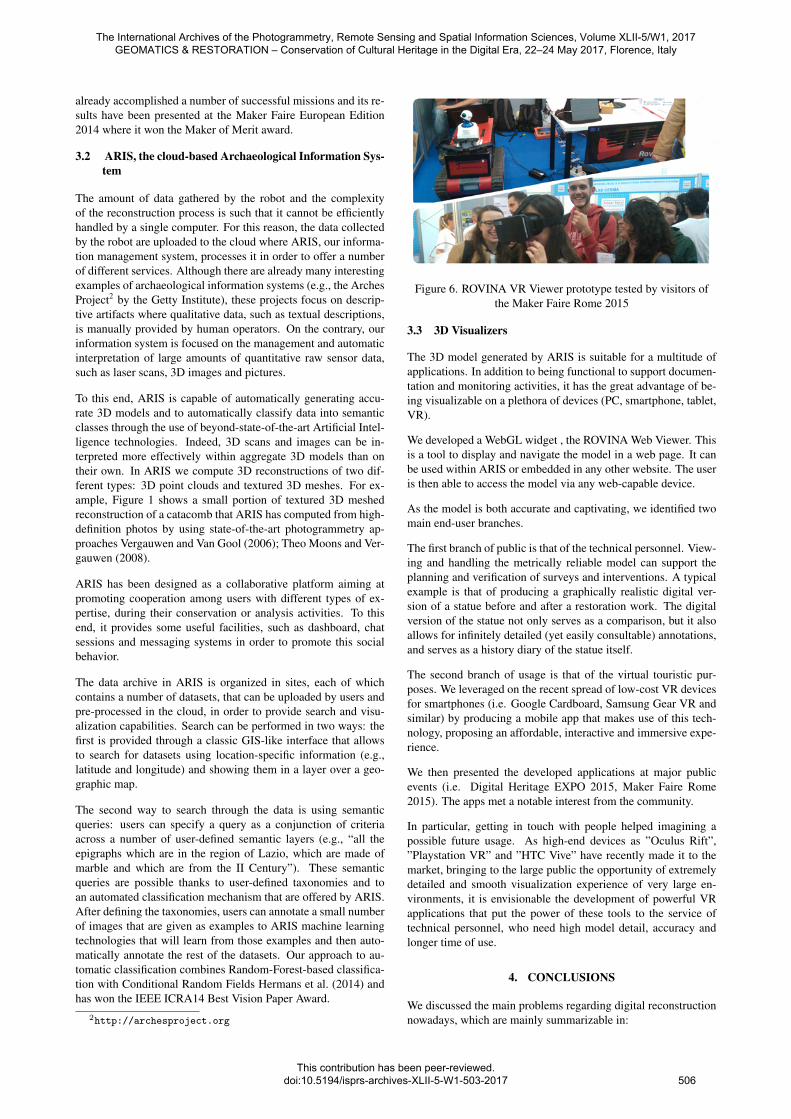
Figure 6. ROVINA VR Viewer prototype tested by visitors ofthe Maker Faire Rome 2015
3.3 3D Visualizers
The 3D model generated by ARIS is suitable for a multitude ofapplications. In addition to being functional to support documen-tation and monitoring activities, it has the great advantage of be-ing visualizable on a plethora of devices (PC, smartphone, tablet,VR).
We developed a WebGL widget , the ROVINA Web Viewer. Thisis a tool to display and navigate the model in a web page. It canbe used within ARIS or embedded in any other website. The useris then able to access the model via any web-capable device.
As the model is both accurate and captivating, we identified twomain end-user branches.
The first branch of public is that of the technical personnel. View-ing and handling the metrically reliable model can support theplanning and verification of surveys and interventions. A typicalexample is that of producing a graphically realistic digital ver-sion of a statue before and after a restoration work. The digitalversion of the statue not only serves as a comparison, but it alsoallows for infinitely detailed (yet easily consultable) annotations,and serves as a history diary of the statue itself.
The second branch of usage is that of the virtual touristic pur-poses. We leveraged on the recent spread of low-cost VR devicesfor smartphones (i.e. Google Cardboard, Samsung Gear VR andsimilar) by producing a mobile app that makes use of this tech-nology, proposing an affordable, interactive and immersive expe-rience.
We then presented the developed applications at major publicevents (i.e. Digital Heritage EXPO 2015, Maker Faire Rome2015). The apps met a notable interest from the community.
In particular, getting in touch with people helped imagining apossible future usage. As high-end devices as ”Oculus Rift”,”Playstation VR” and ”HTC Vive” have recently made it to themarket, bringing to the large public the opportunity of extremelydetailed and smooth visualization experience of very large en-vironments, it is envisionable the development of powerful VRapplications that put the power of these tools to the service oftechnical personnel, who need high model detail, accuracy andlonger time of use.
4. CONCLUSIONS
We discussed the main problems regarding digital reconstructionnowadays, which are mainly summarizable in:
The International Archives of the Photogrammetry, Remote Sensing and Spatial Information Sciences, Volume XLII-5/W1, 2017 GEOMATICS & RESTORATION – Conservation of Cultural Heritage in the Digital Era, 22–24 May 2017, Florence, Italy
This contribution has been peer-reviewed. doi:10.5194/isprs-archives-XLII-5-W1-503-2017
506

(a) ARIS geographical information system (b) ARIS dashboard
(c) ARIS point cloud 3D viewer (d) ARIS semantic annotation tool
Figure 4. ARIS web interface
• high cost, in terms of time and resources, of the variousphases involved in the process
• accesibility of the sites of interest
• reusability and ease of distribution of the products of thedigitization
We then presented the solution proposed, designed and devel-oped during the FP7 European Project ”ROVINA”, whose lifetime span has ranged from 2013 to 2016. The project introduceda strong automation component at several layers in the process,from the involvement of a robotic platform for acquiring the datato the automation of the processing and distribution of these dataand the products of their exploitation.
We highlighted and described the technological components in-cluded and eventually made an overview of the public reaction tothe project, which revealed an opportunity of putting the technol-ogy once more at the service of culture and restoration.
ACKNOWLEDGEMENTS
This work has partly been supported by the European Commis-sion under contract number FP7-600890-ROVINA.
References
Agarwal, P., Grisetti, G., Tipaldi, G., Spinello, L., Burgard, W.and Stachniss, C., 2014. Experimental analysis of dynamiccovariance scaling for robust map optimization under bad ini-tial estimates. In: Proc. of the IEEE Int. Conf. on Robotics &Automation (ICRA), Hong Kong, China.
Barber, D. M., Dallas, R. W. and Mills, J. P., 2006. Laser scan-ning for architectural conservation. Journal of ArchitecturalConservation 12(1), pp. 35–52.
Basso, F., Pretto, A. and Menegatti, E., 2014. Unsupervised in-trinsic and extrinsic calibration of a camera-depth sensor cou-ple. In: Proc. of: IEEE International Conference on Roboticsand Automation (ICRA), pp. 6244–6249.
Beraldin, J.-A., Picard, M., El-Hakim, S. F., Godin, G., Valzano,V., Bandiera, A. et al., 2005. Combining 3 d technologies forcultural heritage interpretation and entertainment. In: Proc.SPIE, Vol. 5665, pp. 108–118.
Bogoslavskyi, I., Vysotska, O., Serafin, J., Grisetti, G. and Stach-niss, C., 2013. Efficient traversability analysis for mobilerobots using the kinect sensor. In: Proceedings of the Euro-pean Conference on Mobile Robots (ECMR).
Drap, P., Sgrenzaroli, M., Canciani, M., Cannata, G. and Sein-turier, J., 2003. Laser scanning and close range photogramme-try: Towards a single measuring tool dedicated to architectureand archaeology. In: CIPA XIXth International Symposium,pp. 1–6.
Hermans, A., Floros, G. and Leibe, B., 2014. Dense 3d semanticmapping of indoor scenes from rgb-d images. In: Robotics andAutomation (ICRA), 2014 IEEE International Conference on,pp. 2631–2638.
Johansson, M., 2002. Explorations into the behaviour of three dif-ferent high-resolution ground-based laser scanners in the builtenvironment. In: Proceedings of the CIPA WG 6 InternationalWorkshop on Scanning for Cultural Heritage Recording.
Kuemmerle, R., Grisetti, G., Strasdat, H., Konolige, K. and Bur-gard, W., 2011. g2o: A general framework for graph optimiza-tion. In: Proceedings of the IEEE International Conference onRobotics and Automation (ICRA), Shanghai, China, pp. 3607–3613.
The International Archives of the Photogrammetry, Remote Sensing and Spatial Information Sciences, Volume XLII-5/W1, 2017 GEOMATICS & RESTORATION – Conservation of Cultural Heritage in the Digital Era, 22–24 May 2017, Florence, Italy
This contribution has been peer-reviewed. doi:10.5194/isprs-archives-XLII-5-W1-503-2017
507
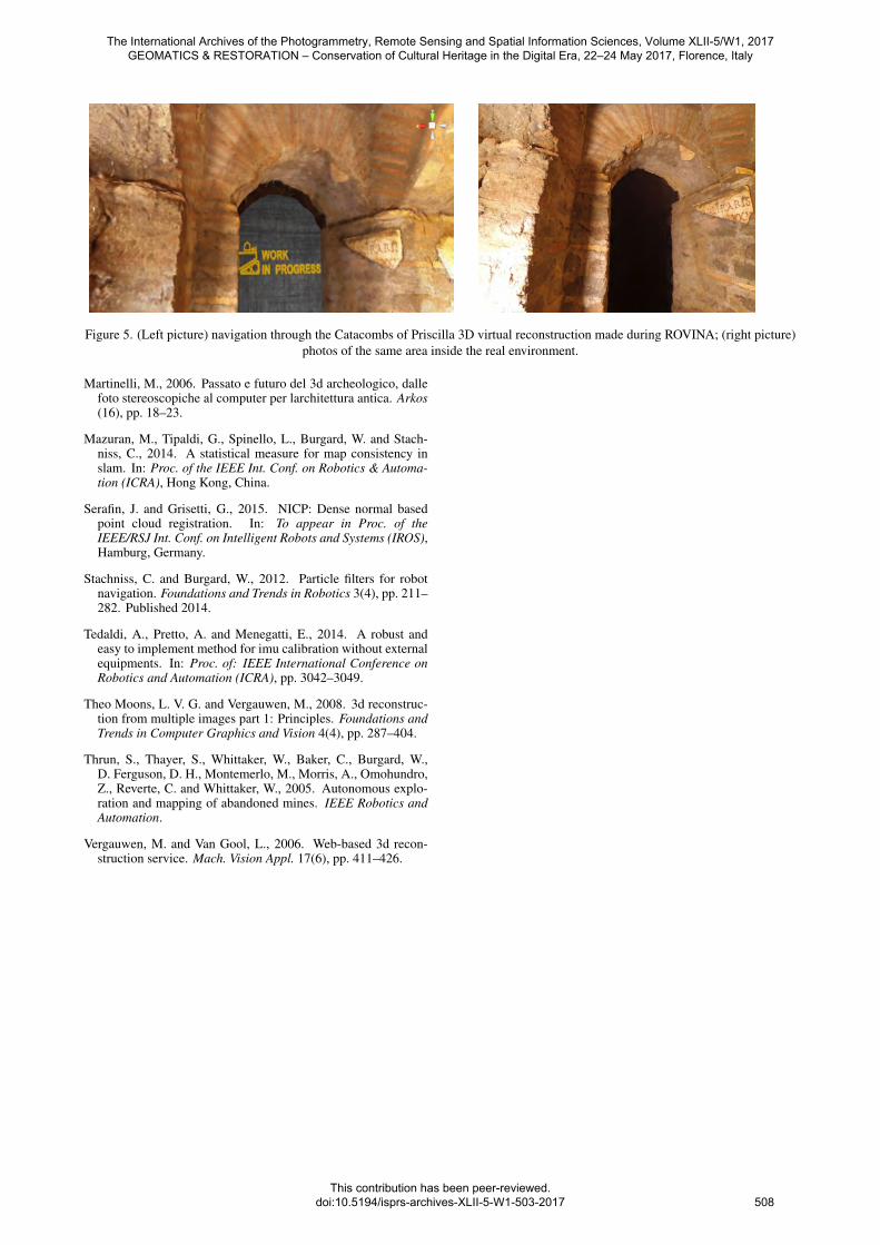
Figure 5. (Left picture) navigation through the Catacombs of Priscilla 3D virtual reconstruction made during ROVINA; (right picture)photos of the same area inside the real environment.
Martinelli, M., 2006. Passato e futuro del 3d archeologico, dallefoto stereoscopiche al computer per larchitettura antica. Arkos(16), pp. 18–23.
Mazuran, M., Tipaldi, G., Spinello, L., Burgard, W. and Stach-niss, C., 2014. A statistical measure for map consistency inslam. In: Proc. of the IEEE Int. Conf. on Robotics & Automa-tion (ICRA), Hong Kong, China.
Serafin, J. and Grisetti, G., 2015. NICP: Dense normal basedpoint cloud registration. In: To appear in Proc. of theIEEE/RSJ Int. Conf. on Intelligent Robots and Systems (IROS),Hamburg, Germany.
Stachniss, C. and Burgard, W., 2012. Particle filters for robotnavigation. Foundations and Trends in Robotics 3(4), pp. 211–282. Published 2014.
Tedaldi, A., Pretto, A. and Menegatti, E., 2014. A robust andeasy to implement method for imu calibration without externalequipments. In: Proc. of: IEEE International Conference onRobotics and Automation (ICRA), pp. 3042–3049.
Theo Moons, L. V. G. and Vergauwen, M., 2008. 3d reconstruc-tion from multiple images part 1: Principles. Foundations andTrends in Computer Graphics and Vision 4(4), pp. 287–404.
Thrun, S., Thayer, S., Whittaker, W., Baker, C., Burgard, W.,D. Ferguson, D. H., Montemerlo, M., Morris, A., Omohundro,Z., Reverte, C. and Whittaker, W., 2005. Autonomous explo-ration and mapping of abandoned mines. IEEE Robotics andAutomation.
Vergauwen, M. and Van Gool, L., 2006. Web-based 3d recon-struction service. Mach. Vision Appl. 17(6), pp. 411–426.
The International Archives of the Photogrammetry, Remote Sensing and Spatial Information Sciences, Volume XLII-5/W1, 2017 GEOMATICS & RESTORATION – Conservation of Cultural Heritage in the Digital Era, 22–24 May 2017, Florence, Italy
This contribution has been peer-reviewed. doi:10.5194/isprs-archives-XLII-5-W1-503-2017 508