Embed Size (px)
Citation preview

Rivers

Drainage BasinA drainage basin is the land area from which a river or stream gets its water supply. Watersheds or divides are the highland areas which separate one basin from another.

Dendritic River PatternA dendritic river pattern is like the veins or a leaf. This pattern is found in level areas with a uniform bedrock or surface.

Trellis River PatternA trellis river pattern is found where there are differences in the bedrock or in mountain-building regions. There may be inclined layers of varying resistances that help form this pattern.

A Parallel River PatternA parallel-pinnate pattern develops where there are long parallel ridges in mountains or hills.

Radial River PatternA radial river pattern develops around a volcano or circular mountain or domed hill.

Rectangular River PatternA rectangular river pattern develops over bedrock which has strong fractures or joints in a rectangular pattern.

Deranged River PatternA deranged river pattern develops where continental glaciers have scoured the land’s surface, rearranging the flows of streams and rivers.

Perennial RiversRivers which flow year round are called perennial rivers.

Seasonal RiversRivers flowing only during a wet season are called seasonal rivers.
Intermittent or Ephemeral RiversRivers that rarely flow, every now and then, are called intermittent or ephemeral rivers. Rivers in deserts are commonly ephemeral or intermittent.

A Stream’s VelocityA river or stream’s velocity is affected by discharge, profile, channel roughness and hydraulic radius.

Stream Discharge and VelocityA stream’s discharge refers to the volume of water flowing per time (m3/s) that it carries. A stream’s velocity is directly related to its discharge.
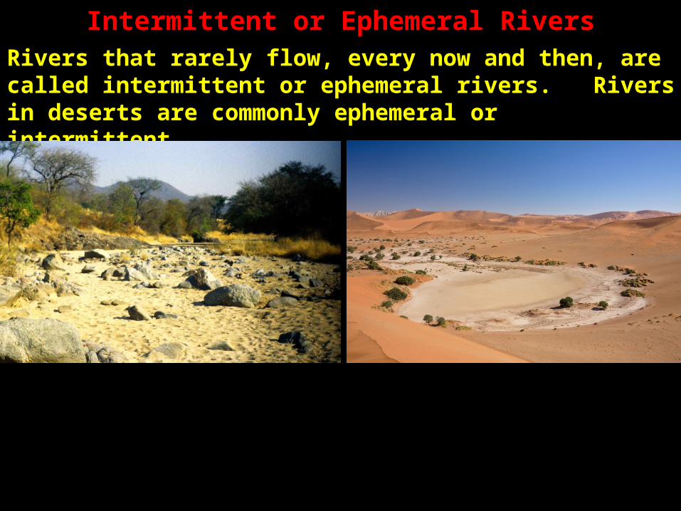
Stream Profile (Gradient) and VelocityThe profile, gradient or degree of slope of a stream affects its velocity with steeper profiles favouring higher velocities. Streams in mountains have steeper profiles while streams in lowlands have more gradual profiles. A stream typically flows slower near its mouth where it joins a lake or ocean. Since rivers generally flow faster downstream than upstream, gradient is not the only factor affecting stream velocity.

Channel Roughness and VelocityThe rougher the channel of a stream, the slower its velocity which is impeded by rough features slowing the flow. Rocks in a river channel and plants along the bottom and sides of a channel reduce a river’s velocity. A mud bottom has less friction than a rocky bottom which helps to speed up a river.

Hydraulic Radius and VelocityA stream’s hydraulic radius is the ratio of its cross-sectional area to its wetted perimeter. A larger hydraulic radius generally means less friction which produces a greater flow and therefore greater velocity. The hydraulic radius is a measure of how efficiently a river flows.
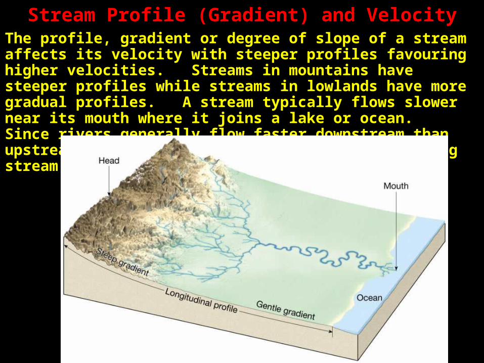
Hydraulic Radius and River Channel Shapes
For two rivers with the same cross-sectional area, a shallower river has a lower hydraulic radius which produces a slower velocity. This is because the river water has more contact with its channel which produces more friction, slowing the river down.

River Velocity Within its ChannelFor a river with an even channel, the water flows fastest in the centre, near the top. In deeper places the flow is faster while in shallower places the flow is slower because there is more surface contact and friction in shallower places.

Erosion within a River ChannelErosion of a stream’s bed and sides happens when the stream’s velocity is higher. Clay and Silt (very fine sand) erodes away first. In low velocity streams, clay and silt are transported the easiest

Transport of Materials by a RiverGravel being carried in a river or stream is deposited unless the velocity is very high. The higher a river’s velocity, the more suspended particles it can carry. As a river slows down, it is likely to deposit materials.

Water Erosion ProcessesWater has four main erosion processes: abrasion, attrition, corrosion and hydraulic action.

AbrasionThe grinding of a river’s bed and sides by suspended particles in the moving water is called abrasion.

AttritionThe grinding of rock and gravel fragments against each other is called attrition.

CorrosionThe dissolving of soluble minerals and transporting them to an ocean is called corrosion.

The Origin of the Saltiness of OceansThe reason oceans are salty is that rivers continually carry dissolved salts from their beds and sides to the oceans.

Hydraulic ActionThe weight of moving water against the bottom and sides of a river channel which slowly erodes it away is referred to as water’s hydraulic action. Water’s hydraulic action is more pronounced in rapids and falls.

Bed LoadBed load refers to the amount of maximum-sized particle that a river can erode and carry away.

Stream Transport of MaterialsThe amount and kind of materials a stream or river carries depends on its discharge and the type of sediments of the river. A river’s capacity is the maximum amount of sediment materials that it can carry suspended in its waters.
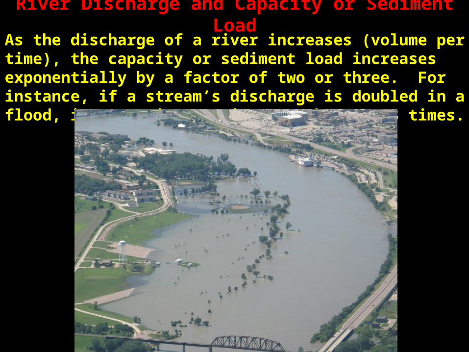
River Discharge and Capacity or Sediment LoadAs the discharge of a river increases (volume per time), the capacity or sediment load increases exponentially by a factor of two or three. For instance, if a stream’s discharge is doubled in a flood, its capacity may increase by 4 to 8 times.

How Streams Carry ParticlesStreams carry particles by traction, saltation, suspension and solution.

TractionWhen streams roll rocks along this is called traction.

SaltationWhen particles are bounced along the bottom of a stream bed, this is called saltation.
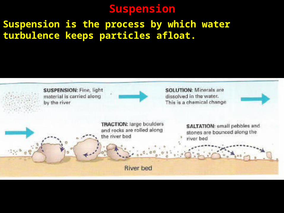
SuspensionSuspension is the process by which water turbulence keeps particles afloat.
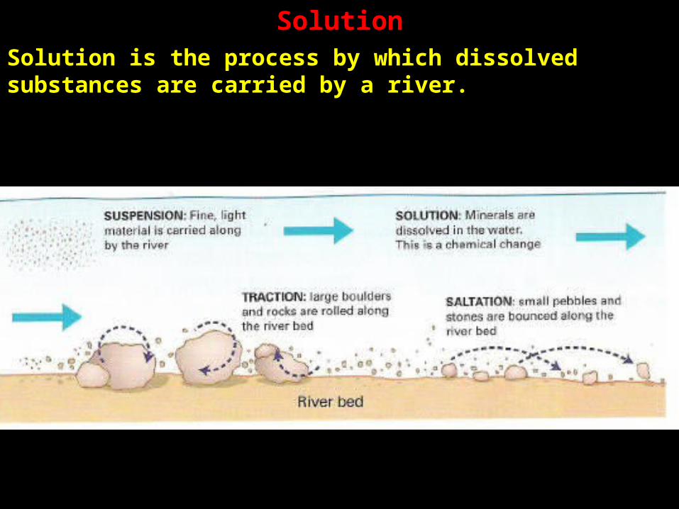
SolutionSolution is the process by which dissolved substances are carried by a river.

AlluviumAlluvium is the term used to describe river-deposited sediment. Alluvium is usually deposited in layers. Finer particles are usually higher because heavier particles settle out first, with the lightest (finest) particles settling out last.

Features Caused by Rivers and StreamsAs a river flows, especially with a more gradual gradient (slope), it meanders (wanders sideways), creating broad curving bends. River banks are eroded at the outside edges, and deposition occurs on the inner curves creating features called point bars. This happens because the fastest and deepest water is found on the outside banks while the slower and shallower water is found on the inner banks of a meander curve.

Erosion in a Meandering RiverAs erosion continues, meanders may connect causing incipient oxbows which later may become oxbow lakes as sediments separate the meander from the main course of the river.

Flood Plains and LeveesSeasonal river floods erode areas on either side of the river to create a flood plain. As fast-moving flood waters, heavy with sediments, spill over onto surrounding shallower flood plains, they slow down and deposit their sediments onto the edge of the river and the flood plain. The raised edges of a river bank are called levees and they re formed by flood waters depositing their sediments on the banks as they slow in the shallower bank region.

BackswampsMoving away from a river with its levees, a person will find lower regions which are referred to as backswamp areas.

Graded and Braided StreamsA graded river or stream maintains a balance, neither eroding its bed nor depositing further sediments. A braided stream carries an especially large load of sand and rock sediments called its bedload. If a braided stream is slowed, it drops much of its sediment and splits into many interlaced channels. Braded streams are common in low relief deserts (flatter) during flash floods and in streams flowing from glaciers. In both of these cases, a sudden flood of water picks up a large amount of sediment and deposits these as they slow.

DeltasDeltas are flat areas of sediment deposits found at river mouths. The cross-connecting channels in deltas are called distributaries. Deltas are enlarged as sediments are deposited and are worn away by the forces of ocean or lake waves. Deltas may be arcuate or fan-shaped like the Nile delta or elongated along the river channel like the Mississippi bird’s foot delta or cuspate or tooth-shaped like the Tiber River delta.

EstuariesIn low-lying, marshy areas where fresh water rivers meander and oceanic tides periodically flow upriver, there is a mixing of waters and sediment deposit, forming an estuary delta. The Cowichan river forms an estuary delta where it flows into Cowichan Bay. Estuaries are regions where river waters are filtered and purified before entering the ocean. They are regions rich in wildlife and in the Cowichan estuary, plentiful in food for salmon during both their early stage and last parts of their life cycle.

Ordering a River or StreamThe complexity of the tributaries that feed into a river can be measured with an ordering system. A 2nd order stream has two tributaries of order 1 flowing into it. After two 2nd order tributaries feed into a stream, it is called a 3rd order stream etc.

Alluvial FansAlluvial fans are deposits of sediment formed by fast-flowing streams carrying large amounts of sediments which abruptly flow onto level plains, slowing the flow and causing the sediments to settle out in the form of fans. Alluvial fans are common in arid or semi-arid environments. Where several alluvial fans grow together, structures called bahadas form.

PlayaIn an enclosed basin with sloping bahadas, the central flat plain may intermittently fill up with water as a shallow lake and then dry through evaporation leaving salts behind. The central flat region is called a playa and may have layers of alkaline salts, sometimes referred to as salt or alkali flats.

WadisIn deserts the dry remains of an ephemeral or intermittent stream is called an arroyo. When water erodes a desert, creating a ravine or canyon, this is referred to as a wadi. In more humid climates, a wadi is referred to as a gorge or canyon.

Other Arid FeaturesMesas are flat-topped hills with steep sides or escarpments. Mesas develop in lands where a resistant layer of sedimentary rock or igneous sill overlays softer sedimentary layers. A butte is a small mesa while a pinnacle is just a pointed remain of a butte. Badlands are regions of soft rock which have been eroded by intermittent water into ravines, gullies and sharp-edged ridges.

The “Aging” of Rivers: “Youthful” RiversYouthful rivers tend to be v-shaped, narrow with fast moving waters due to the steep profiles or gradients they have. Youthful rivers have much erosion on their bottom beds with many boulders and rocks that deflect their waters, causing them to take jagged paths.

Mature RiversMature rivers begin to meander because they have more erosion at their sides than their bottoms. They tend to form narrow floodplains and valleys that they flow through. Mature rivers have fewer rapids and waterfalls. Mature rivers have a lower profile (gradient) and a u-shaped cross-section.

Old Age RiversIn old age rivers, most of their erosion takes place along their sides. They form large flood plains, large curving meanders and oxbow lakes. Old river have raised river banks called levees and away from these are lower-lying parts called backwaters. Old age rivers tend to be wide and shallow.

RejuvenationWhen tectonic movements of the earth’s crust uplift a region causing a steeper gradient (profile), old age rivers may be rejuvenated, making the river once more into a “young” river. With a steeper gradient, the river now has more bottom erosion, carrying away sediments and leaving just rocks and boulders and again taking on a v-shape as it cuts downward through its bedrock.
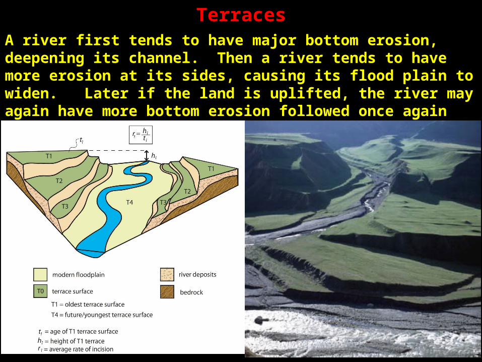
TerracesA river first tends to have major bottom erosion, deepening its channel. Then a river tends to have more erosion at its sides, causing its flood plain to widen. Later if the land is uplifted, the river may again have more bottom erosion followed once again with subsequent side erosion. This pattern produces flat terraces that mark where former flood plains were.

End of Presentation

AA