Embed Size (px)
Citation preview

River Environments at theEnd of the Pleistocene,
Southeast USA
by
David S. Leigh, University of Georgia,
Department of Geography
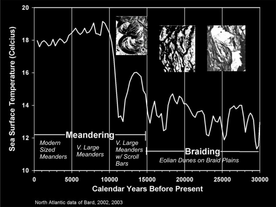
V. Large Meanders w/ ScrollBars
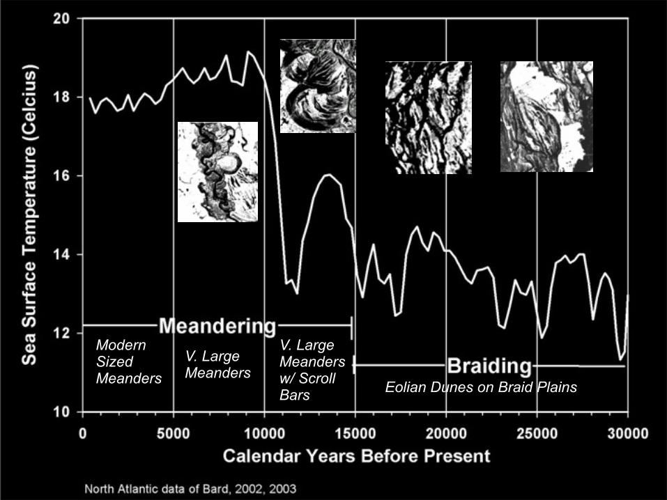
V. Large Meanders
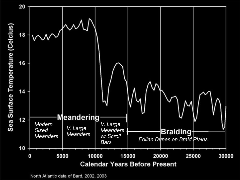
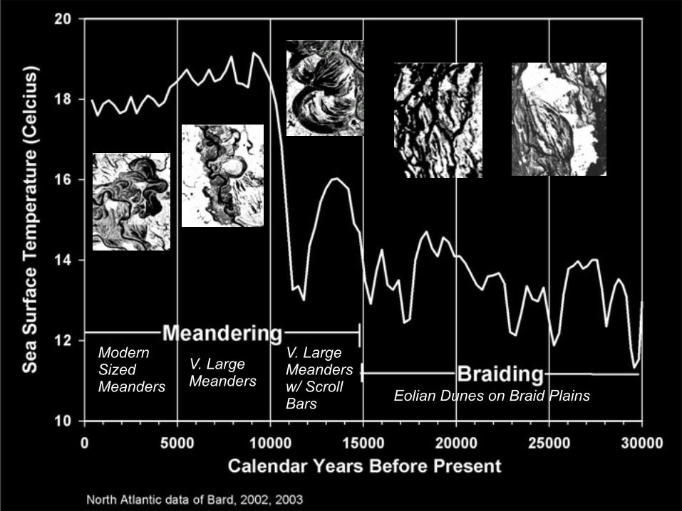
Modern Sized Meanders Eolian Dunes on Braid Plains

V. Large Meanders w/ ScrollBars
V. Large Meanders
Modern Sized Meanders Eolian Dunes on Braid Plains
V. Large Meanders w/ ScrollBars
V. Large Meanders
Modern Sized Meanders Eolian Dunes on Braid Plains
V. Large Meanders w/ ScrollBars
V. Large Meanders
Modern Sized Meanders Eolian Dunes on Braid Plains
V. Large Meanders w/ ScrollBars
V. Large Meanders
Modern Sized Meanders Eolian Dunes on Braid Plains

source: Leigh, In Press, Catena
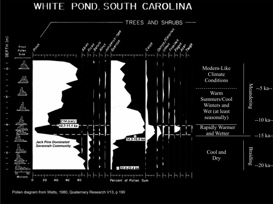
Pollen diagram from Watts, 1980, Quaternary Research V13, p 190
Braiding
Meandering
Cool and Dry
Warm Summers/Cool
Winters and Wet (at least seasonally)
Rapidly Warmer and Wetter
Modern-Like Climate
Conditions
--15 ka--
--10 ka--
--5 ka--
--20 ka--
no data
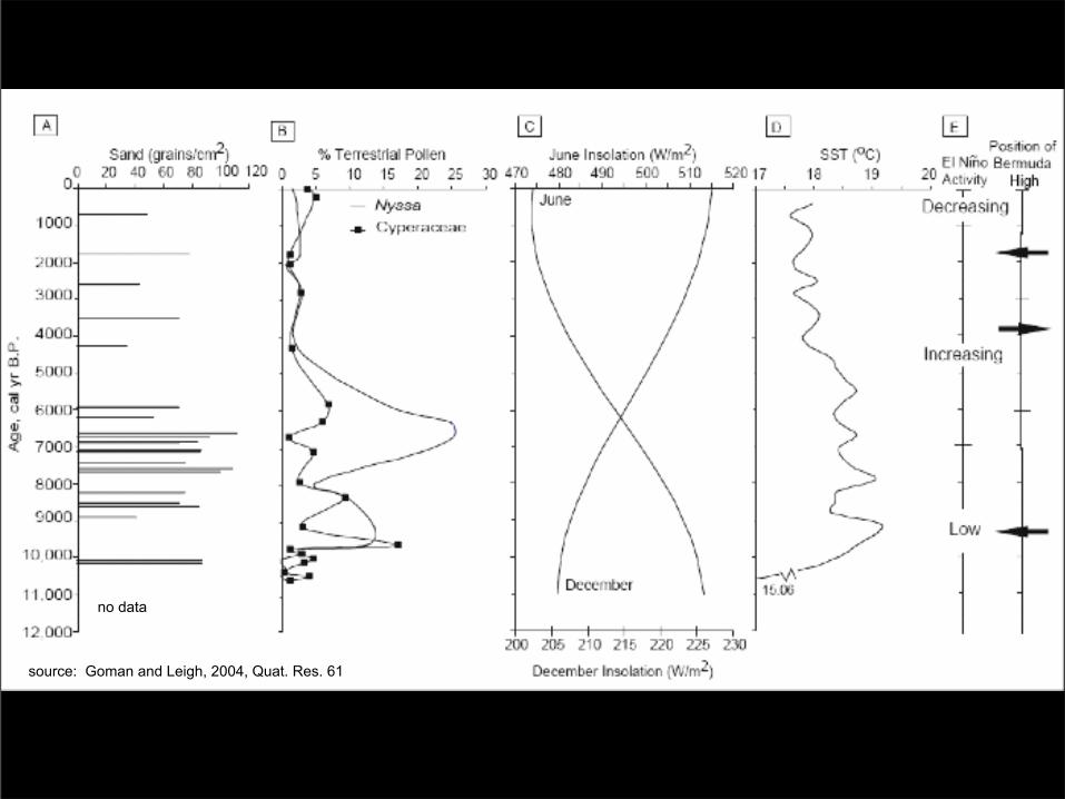
source: Goman and Leigh, 2004, Quat. Res. 61
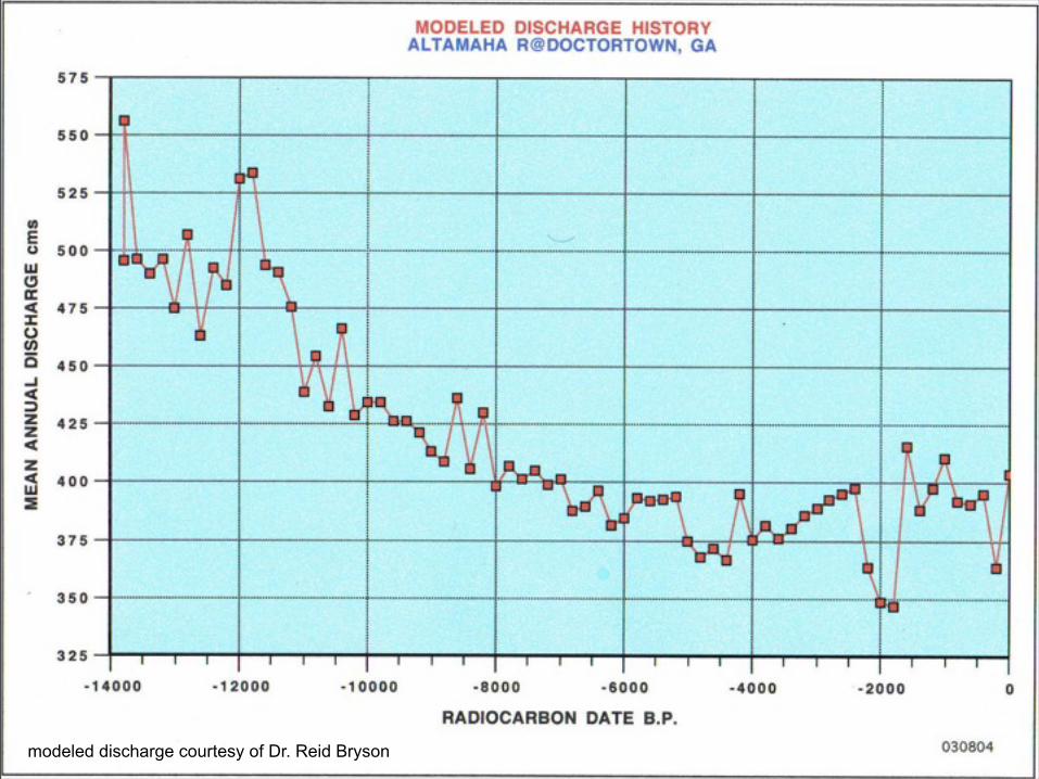
modeled discharge courtesy of Dr. Reid Bryson

Halfway River, northern British Columbia (photo by Martin Geertsema)
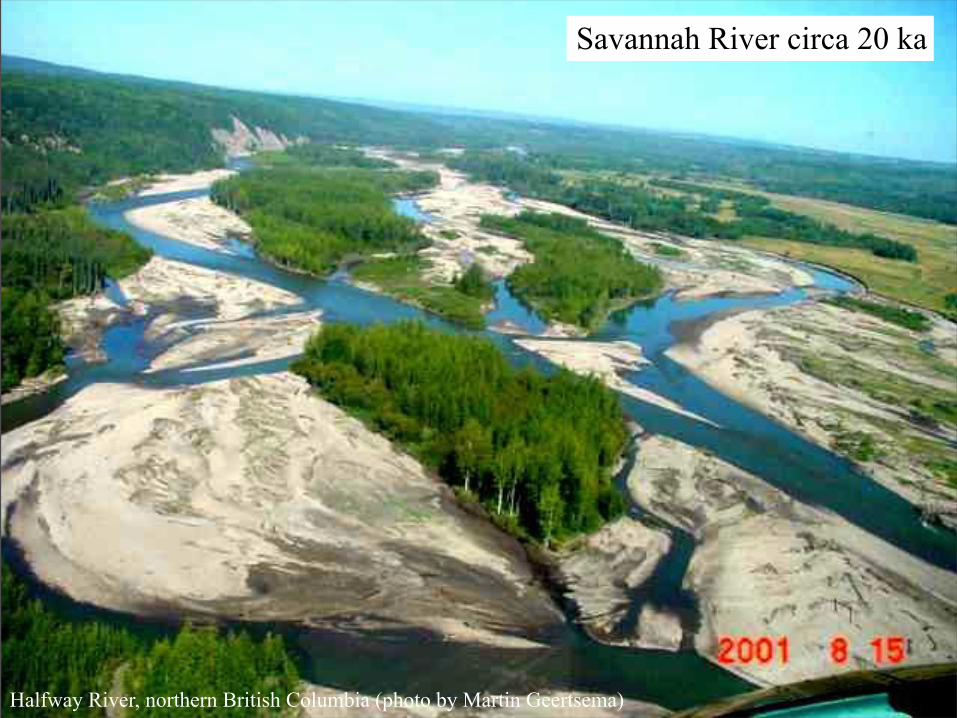
Savannah River circa 20 ka

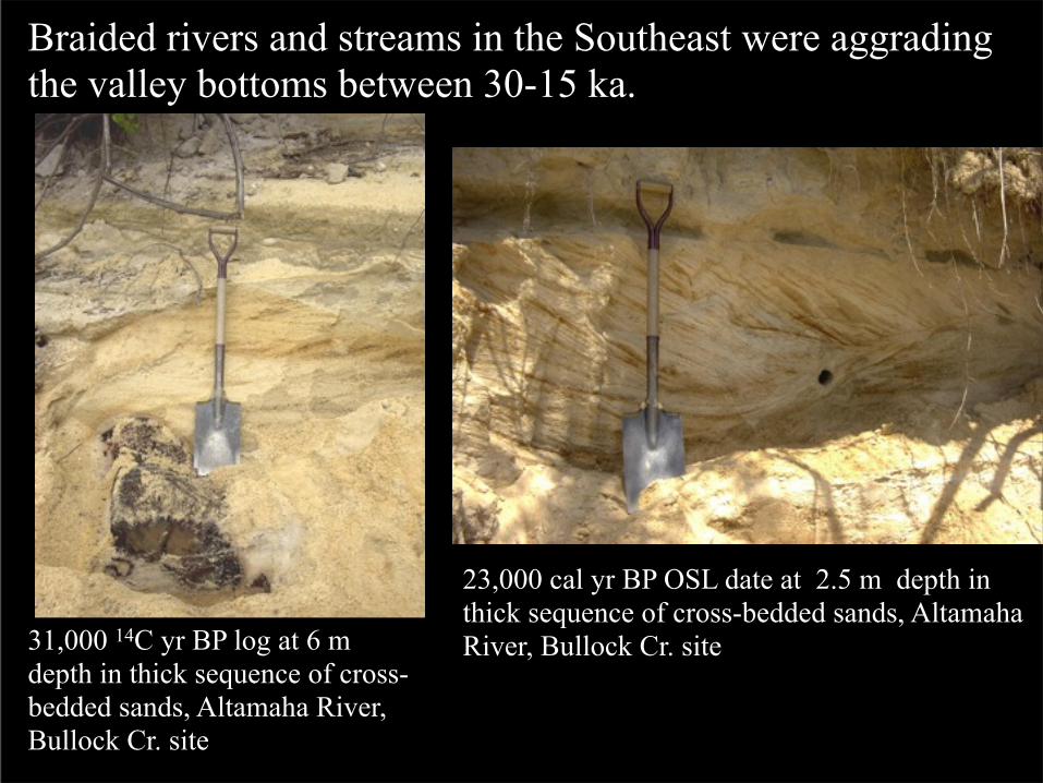
Braided rivers and streams in the Southeast were aggrading the valley bottoms between 30-15 ka.
31,000 14C yr BP log at 6 m depth in thick sequence of cross-bedded sands, Altamaha River, Bullock Cr. site
23,000 cal yr BP OSL date at 2.5 m depth in thick sequence of cross-bedded sands, Altamaha River, Bullock Cr. site
Pee Dee Valley at U.S. Highway 401
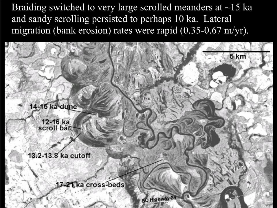
Braiding switched to very large scrolled meanders at ~15 ka and sandy scrolling persisted to perhaps 10 ka. Lateral migration (bank erosion) rates were rapid (0.35-0.67 m/yr).
Pee Dee River at SC Highway 34

Parabolic dunes were commonplace on the late Pleistocene braided and scrolled floodplains until circa 12-13 ka
Western Australia, photo by Patirck Hesp
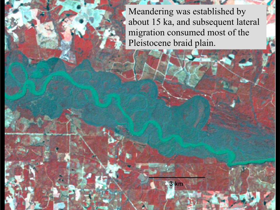
Meandering was established by about 15 ka, and subsequent lateral migration consumed most of the Pleistocene braid plain.

Paleodischarge for meandering channels was greatest from 15-5 ka and more modern-like during the last 5 ka.

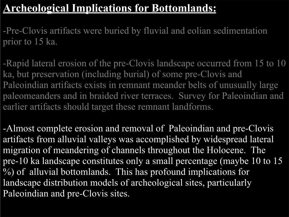
Archeological Implications for Bottomlands:
-Pre-Clovis artifacts were buried by fluvial and eolian sedimentation prior to 15 ka.

Archeological Implications for Bottomlands:
-Pre-Clovis artifacts were buried by fluvial and eolian sedimentation prior to 15 ka.
-Rapid lateral erosion of the pre-Clovis landscape occurred from 15 to 10 ka, but preservation (including burial) of some pre-Clovis and Paleoindian artifacts exists in remnant meander belts of unusually large paleomeanders and in braided river terraces. Survey for Paleoindian and earlier artifacts should target these remnant landforms.
-Almost complete erosion and removal of Paleoindian and pre-Clovis artifacts from alluvial valleys was accomplished by widespread lateral migration of meandering of channels throughout the Holocene. The pre-10 ka landscape constitutes only a small percentage (maybe 10 to 15 %) of alluvial bottomlands. This has profound implications for landscape distribution models of archeological sites, particularly Paleoindian and pre-Clovis sites.

Graphic of lateral erosion
Summary and Conclusions:
-Coastal Plain rivers of the Southeast were braided at the end of the Pleistocene until about 15 ka. High sediment yield, related to less protective plant cover, resulted in braiding. Eolian sand commonly blew from the braid plains and deposited riverine parabolic dunes.

Summary and Conclusions:
-Coastal Plain rivers of the Southeast were braided at the end of the Pleistocene until about 15 ka. High sediment yield, related to less protective plant cover, resulted in braiding. Eolian sand commonly blew from the braid plains and deposited riverine parabolic dunes.
-Relatively rapid warming and increased moisture at about 15 to 10 ka stimulated more dense plant cover, reducing sediment yield, and causing the formation of meandering channels. Bankfull floods were very large, creating much larger river channels than today, and lateral erosion was rapid with relatively sandy river channels and floodplains. Eolian dunes formed on some sandy scroll bars.
-Early and Middle Holocene channels remained large due to relatively wet conditions and large bankfull floods, but vertical accretion became an important sedimentary component. River channels became modern-like at about 5-6 ka.

Acknowledgements:
-Funds in support of this research have been provided by the United States Army (Fort Bragg and Fort Stewart Environmental Divisions), the South Carolina Department of Transportation, the National Science Foundation, the University of Georgia, and donors to the Kolb Site .
Follow-up references:
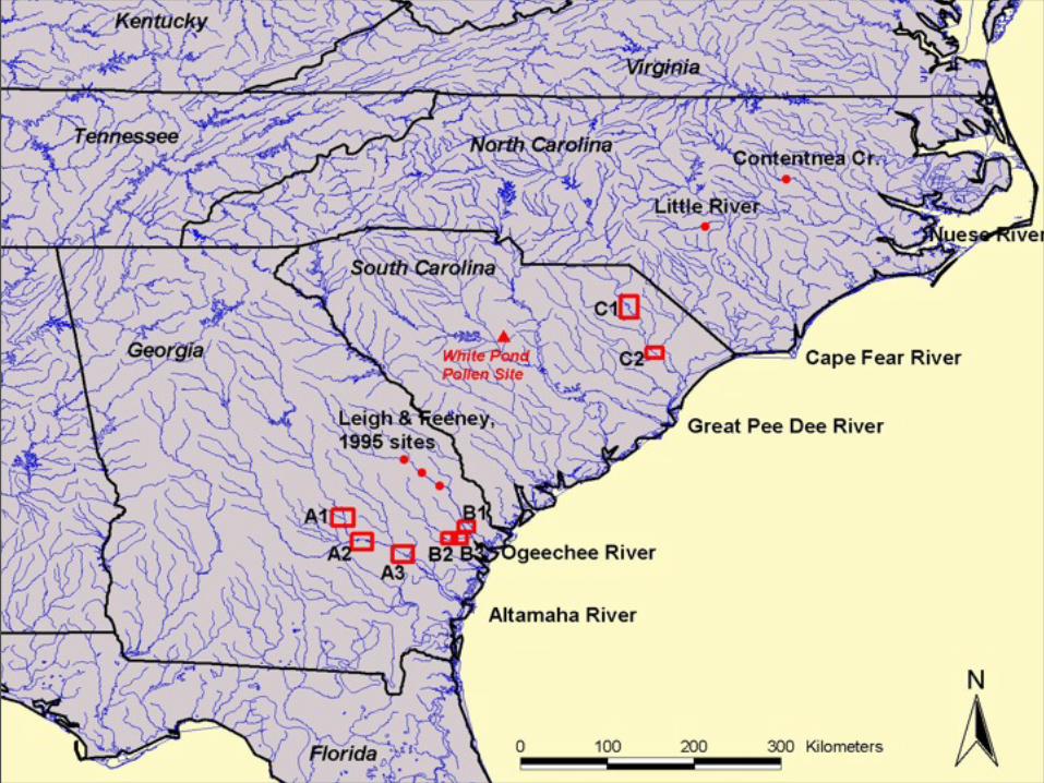
Leigh, D.S. and Feeney, T.P., 1995. Paleochannels indicating wet climate and lack of response to lower sea level, Southeast Georgia. Geology 23, 687-690.
Ivester, A.H., Leigh, D.S., Godfrey-Smith, D.I., 2001. Chronology of inland eolian dunes on the Coastal Plain of Georgia, USA. Quaternary Research 55, 293-302.
Ivester, A.H., and Leigh, D.S., 2003. Riverine Dunes on the Coastal Plain of Georgia, U.S.A. Geomorphology 51, 289-311.
Leigh, D.S., Srivastava, P., Brook, G.A., 2004. Late Pleistocene braided rivers of the Atlantic Coastal Plain, USA. Quaternary Science Reviews 23, 65-84.
Goman, M., Leigh, D.S., 2004. Wet early to middle Holocene conditions on the upper Coastal Plain of North Carolina, USA. Quaternary Research 61, 256-264.
Leigh, D.S., In Press. Terminal Pleistocene Braided to Meandering Transition in Rivers of the Southeastern USA. Catena.