Embed Size (px)
Citation preview

Harlem River
Bridges Access
PlanWorkshop Round 2September 10, 2015

AgendaHarlem River Bridges Access Plan: Overview
Participation:Your comments, questions, and feedback(30‐45 min)
Wrap Up:Share your group’s main comments and preferred designs(10‐15 min)
Presentation: Background +overview of concepts for review(15‐20 min)

Project GoalsHarlem River Bridges Access Plan: Overview
• Connect vibrant neighborhoods and major destinations on both sides of river
• Improve street safety and traffic flow• Investigate feasibility of adding or
enhancing pedestrian and bicycle bridge access as part of capital program
OutcomeShort-term: Project development• Initiate select projects for Community
Board review in 2016
Long-term: Planning document • Focus on DOT facilities• Guide future investment on bridges
and on-street bridge approaches– Enhance pedestrian ramps– Add bicycle access where
desired/feasible

Planning ProcessHarlem River Bridges Access Plan: Overview
Twelve community workshops – Round 1, June 2015 :
• Existing Conditions/Major Destinations – Round 2, Fall 2015:
• Preliminary Concept Review– Round 3, Winter 2016:
• Draft Plan– Planning Document Release: Spring 2016
Surveys and field work– Summer & Fall 2015
All final proposals will be reviewed through the regular Community Board Process before implementation

Summary of Feedback from Previous Workshops/SurveysOverview
• Difficult to cross the street at major intersections near bridge entrances
– Crossing ramps at several locations is difficult
• Better wayfinding/connections needed to major destinations:
– All bridges with pedestrian access– Bronx Terminal Market– Yankee Stadium/Heritage Park– Waterfront/Mill Pond Park Esplanade– Randall’s Island
• Better lighting desired on and near all bridges
• Interest in new or upgraded bicycle routes leading to and across Harlem River from network
– Protected paths preferred where feasible– East‐West connections emphasized
• Long‐term improvements to bridges themselves needed, including ADA compliance and dedicated bicycle routes
– Investigation ongoing—will be addressed at next round of workshops
Mill Pond Park
Bronx Terminal Market

Workshop Round 2 OverviewHarlem River Bridges Access Plan: Overview
Preliminary Concept Review
• Following are a series of preliminary concepts for your review and feedback
– Concepts are numbered in order to refer back to the map
– Concepts developed in response to feedback from first round of workshops
• We want to hear from you! Based on feedback, any or all concepts may be either:
– Advanced to the next round of planning
– Modified– Scrapped entirely
• Please hold comments to the participation phase—we want to make sure your comments are recorded so that they can be incorporated into the plan
Map subject to changeBased on your feedback!
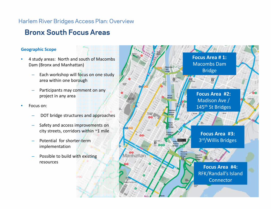
Focus Area #4:RFK/Randall’s Island
Connector
Focus Area #2:Madison Ave /145th St Bridges
Focus Area # 1:Macombs Dam
Bridge
Bronx South Focus AreasHarlem River Bridges Access Plan: Overview
Geographic Scope
• 4 study areas: North and south of Macombs Dam (Bronx and Manhattan)
– Each workshop will focus on one study area within one borough
– Participants may comment on any project in any area
• Focus on:
– DOT bridge structures and approaches
– Safety and access improvements on city streets, corridors within ~1 mile
– Potential for shorter‐term implementation
– Possible to build with existing resources

Preliminary ConceptsBronx South, Focus Area #1: Macombs Dam Bridge
• Throughout: Wayfinding and enhanced lighting
• Concept 1‐A: Enhance Ramp Crossings across Major Deegan
• Concept 1‐B: East‐West Connection to Grand Concourse
1 2 3 4

Existing: Macombs Dam Bridge
Potential: Signalized Crossing
Concept 1-A: Enhance Ramp Crossings across Major DeeganBronx South, Focus Area #1: Macombs Dam Bridge
Potential: Enhanced markings
1 2 3 4
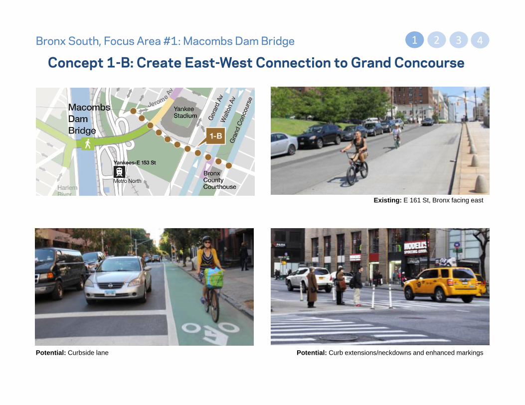
Concept 1-B: Create East-West Connection to Grand ConcourseBronx South, Focus Area #1: Macombs Dam Bridge
Existing: E 161 St, Bronx facing east
Potential: Curbside lane Potential: Curb extensions/neckdowns and enhanced markings
1 2 3 4

Preliminary Concepts
Bronx South Focus Area #2: 145th St and Madison Ave Bridges
• Concept 2‐A: Enhanced Waterfront Connection
• Concept 2‐B: Bronx Terminal Market/Heritage Field Connection
• Concept 2‐C: 145th St Bridge East‐West Connection
• Concept 2‐D: Madison Ave Bridge East‐West Connection
1 2 3 4

Concept 2-A: Enhanced Waterfront Connection
Bronx South Focus Area #2: 145th St and Madison Ave Bridges
Potential: Crosswalk
1 2 3 4
Existing: Gateway Center Blvd, Bronx, facing northeast
Concept Description
• Explore options for enhanced crossings on corridor• Curb extensions• Markings• Actuated signal?
• Wayfinding signage • Add lighting• Add street furniture such as bicycle rack at
destinations

Concept 2-B: Bronx Terminal Market/Heritage Field ConnectionBronx South Focus Area #2: 145th St and Madison Ave Bridges
Existing: 153rd St
1 2 3 4
Potential: Shared Lane Markings Potential: WayfindingPotential: Curbside Bike Lanes

Potential: Shorter, safer pedestrian crossings
Concept 2-C: 145th St Bridge, 149th St Access Improvements Bronx South Focus Area #2: 145th St/Madison Ave Bridges 1 2 3 4
Existing Conditions: 149th Street at Major Deegan Expwy Potential: 149th St two-way shared lane connecting to Melrose Ave

Existing Conditions: 138th Street at Major Deegan Expressway
Potential: On‐Street Bicycle Facilities
Concept 2-D: 138th St/Madison Ave Bridge Access Improvements
1 2 3 4
Concept Description
• Safer bridge access & improved access to major destinations:
– Mill Pond Park, Bronx Terminal Market (shopping mall), Grand Concourse, and 2, 4, 5 trains
• Wayfinding signage and lighting
Potential:Curb extensions, neckdowns,
and high-visibility markings
Bronx South Focus Area #2: 145th St/Madison Ave Bridges

Preliminary ConceptsBronx South, Focus Area #3: Third Av and Willis Av Bridges
• Concept 3‐A: Targeted Intersection Improvements at Bridge Approaches
• Concept 3‐B: Corridor improvements along Existing Bicycle Route
1 2 3 4

Bronx South, Focus Area #3: Third Av and Willis Av Bridges
Concept 3-A: Intersection Improvements at Bridge Approaches
Existing: Willis Ave at E 135 St, Bronx facing north
Potential: Curb extensions or neckdowns
1 2 3 4
Potential: Wayfinding

Existing: Willis Ave, Bronx
Potential: Protected Path
Bronx South, Focus Area #3: Third Av and Willis Av Bridges
Concept 3-A: Intersection Improvements at Bridge Approaches1 2 3 4
Potential: Curb extensions
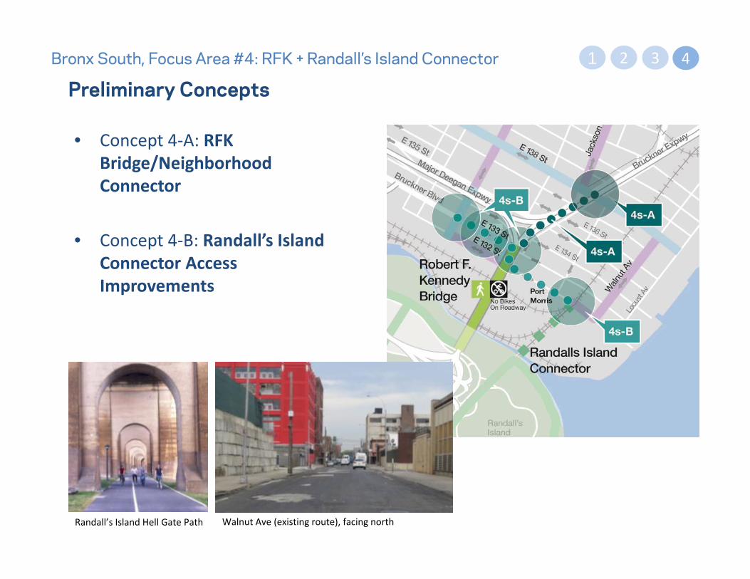
Preliminary ConceptsBronx South, Focus Area #4: RFK + Randall’s Island Connector
• Concept 4‐A: RFK Bridge/Neighborhood Connector
• Concept 4‐B: Randall’s Island Connector Access Improvements
2 3 41
Randall’s Island Hell Gate Path Walnut Ave (existing route), facing north

Existing: Bruckner Blvd at 138 St, facing south
Potential: Two-Way Off-Street Path
Concept 4-A: RFK Bridge Connector2 3 41
Concept Description
• Safer pedestrian crossings at E 138 St and Bruckner Blvd
• Install wayfinding signage/LED lighting• Possible new off‐street cycling routes connecting
South Bronx network to Randall’s Island, Queens and Manhattan
• Connects to 4.5 miles of greenway recreational paths
Potential: Curb extensions/neckdowns and enhanced markings
Bronx South, Focus Area #4: RFK + Randall’s Island Connector

Existing: E 133 St at Bruckner Blvd, facing east
Bronx South Focus Area: RFK + RI Connector
Concept 4-B: E 133 St/Bruckner Blvd East – West Connection
Potential: Two-Way Protected Path
2 3 41
Concept Description
• Install wayfinding signage + LED lighting• Targeted pedestrian improvements along E 133 St• Possible upgrade to existing bicycle route
– E 133 St to two‐way bicycle path from St Anns Av to Cypress Av
– Connect to RI Connector with buffered lanes (two way or east‐west pair) on E 132‐ E 133 St
Existing: E 132 St, between Cypress Ave and Amtrak Bridge

Break Out Groups30 Minutes Discussion, 15 Minutes Share Out

Questions?
Thank you!