Embed Size (px)
Citation preview
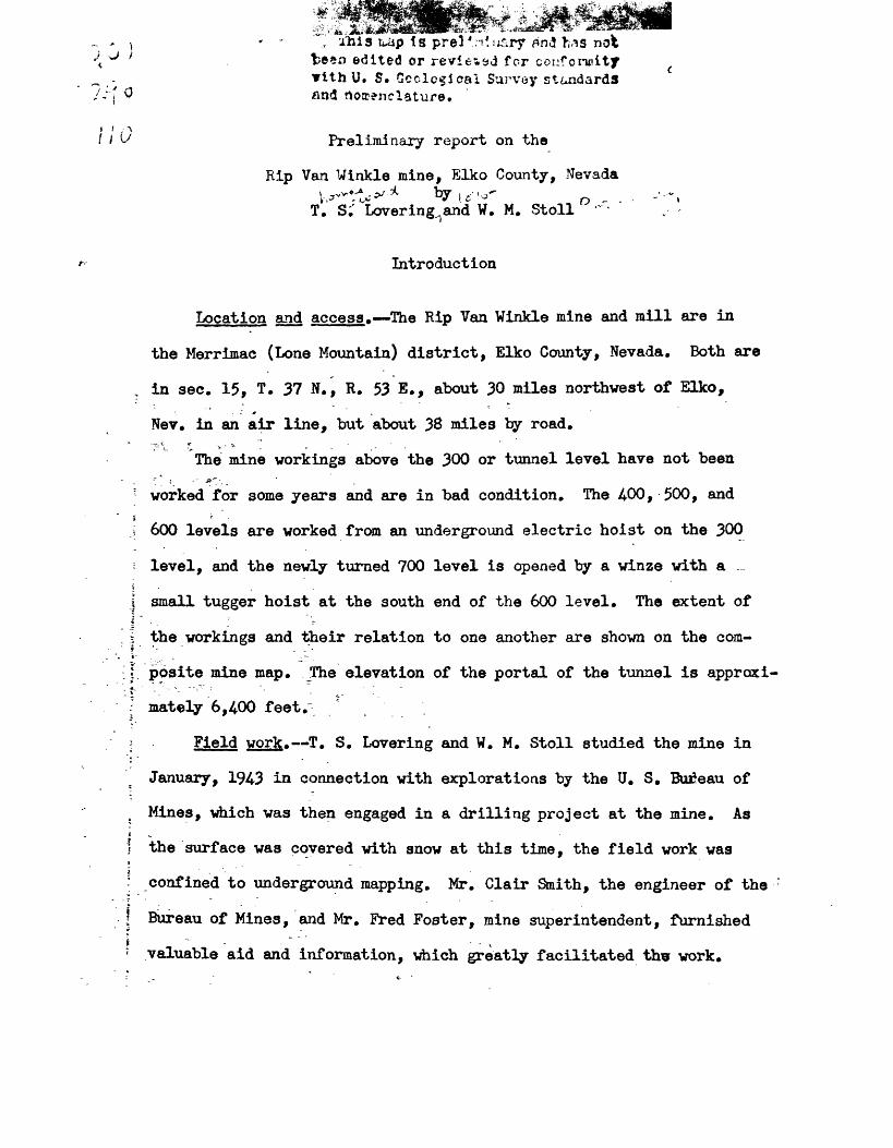
/his tuip is prel'n*u«iry f»nd has nofc ^ fcesn edited or reviewed for conformity
with U. S. Geological Survey standards ' and nomenclature.
\' Preliminary report on the
Rip Van Winkle mine, Elko County, Nevada
T. S^ Lovering^and W. M. Stoll '~~- " .- -
Introduction
Location and access. The Rip Van Winkle mine and mill are in
the Merrimac (Lone Mountain) district, Elko County, Nevada. Both are
in sec. 15, T. 37 N., R. 53 E., about 30 miles northwest of Elko,
Nev. in an air line, but about 38 miles by road.
The mine workings above the 300 or tunnel level have not been'" ' ! " *" ..
; worked for some years and are in bad condition. The 4-00, 500, andi '<\ 600 levels are worked from an underground electric hoist on the 300
i level, and the newly turned 700 level is opened by a winze with a ...
i small tugger hoist at the south end of the 600 level. The extent of
i the workings and their relation to one another are shown on the com
posite mine map. JFhe elevation of the portal of the tunnel is approxi-
: mately 6,400 feet."
! Field work. T. S. Levering and W. M. Stoll studied the mine in
January, 1943 in connection with explorations by the U. S. Bureau of
t Mines, which was then engaged in a drilling project at the mine. As
I the surface was covered with snow at this time, the field work was
confined to underground mapping. Mr. Glair Smith, the engineer of the
j Bureau of Mines, and Mr. Fred Foster, mine superintendent, furnished
< valuable aid and information, which greatly facilitated thw work.

2.
Production and Economics
* The total protraction of the mine is unknown but probably is
substantial, judging by the stopes, the rate of production in 1943,
and the figures for preceding years. Ore was discovered in the 1860 ! s'-' ^*$r "^ ,S "" '^-- " " V x~ -"> " "'* * " ^ " " ' " ""' ^\ ~ "" '" '
and'mining'has been carried on sporadically since that time. The
Rip Van Winkle Consolidated Mining Co., financed in large part by
employees of the Utah Copper Co., took over the mine a few years ago
and built a modern 75-ton flotation mill on the property in 1939. *&
1940 an effort was made to mill a large tonnage of ore which was not
mined selectively, ,The grade of the ore thus mined was so low that
the operation proved unprofitable and selective mining of a smalleri \ - ,i '* i tonnage has been employed since. Nearly 30,000 tons of ore were
milled in 1940 but in terms of recovered metal this ore averaged
only 2.1 percent lead, 1.6 percent zinc, 0.02 percent copper, and1 "3 -=-, - - ~'
« I carried 7.5 ounces of silver and 0.0013 ounce of gold per ton._/ Theo
>,JO o
3
1
as ; / |g ! ' jy Minerals Yearbook, Review of 1940, U. S. Bur. of Mines, pp.389,S j I 395, 1941. |
° mill was closed for pearly four months in 1941 and the total mine
< * '£'
5*uction for that year was 7,376 tons, from which was produced 691 tons { , ~*of lead concentrate and 554 tons of zinc concentrate. J The leadj____ _ _t . -. _
L/ Minerals Yearbook, Review of 1941, Gold, silver, copper, lead, ] and zinc in Nev., ff. S. Bur. of Mines, p. 18, 1942.i____________;______-_____________________________________________
.1
^concentrate carried approximately 442 tons of lead, 7 tons of copper,
88,295 ounces of silver, and 13 ounces of gold. The zinc concentrate
contained 270 tons of zinc, 2,827 ounces of silver, 3 ounces of gold,
3.
and slightly less than 3 tons of lead and 3 tons of copper. If the
mill recovered 90 percent of the metals present, this production indi
cates that the grade of the average ore in 1941 was 0.0024 ounce of gold
per ton, 13»7 ounces of silverrper ton, 6.7 percent lead, 4^1 percent. - - - , . _ -' .,-« , .' -^,
zinc, and 0.15 percent copper. The figures for the grade of ore for
1942 are probably close to those of 1941.
In 1943 the zinc concentrates were shipped to Amarillo, Texf , and
the net return to the company, exclusive of mining and milling costs,
was from $20 to $25 per ton of concentrates averaging 50 percent zinc.
As mining costs are high, the zinc in the ore pays only a small part of
the total cost of extraction; the silver and lead content of the ore,j- ' ' ~~s'*'- _ , - ~ ~ make mining possible. The silver in the ore is more closely associated
with lead than with zinc and as a consequence "zincy ore" is avoided.
There are probably several thousand tons of such "zincy ore" available* :i -1 .. 1 "T .
for mining at present, but it is believed it would be uneconomic to* - ->- " T".
extract this material unless a better net price could be realized on* .* - ~4 *«-
£inc than" at present*- Although a substantial additional tonnage of lead-
silver-ziric ore seem! blocked out, its grade is so close to the border-} - £.: " f - .: , ~. -v '- -
line dividing profit^and loss that the monthly operations are sometimes
in the red and sometimes in the black. A slight decrease in grade could
^asily result in a shutdown and, conversely, a betterment of grade wouldi ' .increase the output and guarantee continued operation.
I - Geology
The country rock of the mine is chiefly cherty shale, granite
porphyry, intrusion breccia, and shale breccia. Most of the ore is
localized along branching pre-mineral faults, in part as veins that
represent filled fissures and in part as a replacement of the 'country. ^. *
rock adjacent to the veins.
Formations. Shaly strata comprise the dominant country rocks
exposed in the mine workings (dee geologic map plan and sections).
Listed in the order of abundance the shale variants include nodular and
lenticular thin-bedded black cherty shale, medium-bedded siliceous black
shale, black clay shale, brownish black calcareous shale, and dark-gray
shaly limestone. Because of faulting and lack of crosscuts, the writers
were unable to work out the stratigraphy in detail, but portions of the
general sequence are indicated in the geologic sections of the mine.
No fossils were found in the beds, but the work of finmons^/ in the" -*'
_J Bnmons, W. H., A reconnaissance of some nining districts in Elko, Lender, and Eureka Counties, Nev.: Geol. Survey Bull. 408, 1910.?. -," ,
adjacent region suggests that the sedimentary rocks are cherty shales\
ir( the lower part of the formation, the so-called "Lower Coal Measures, n: I '. V-which lie above the Diamond Peak quartzite. -. ,.
* ,:J ^ The typical igneous rocks present have been examined under the
microscope by R. E. Head of the Bureau of Mines and identified as ,
granite porphyry, according to Mr. Glair a&ith. The granite porphyry
is a moderately fine-grained granular rock containing abundant phenocrysts
ofj orthoclase and some quartz* In places angular fragments of granite
porphyry lie in a matrix of finer-grained igneous rock that may be a , -
trachyte porphyry. Shale fragments are locally abundant in both rocks .I -""'-. " " --.
and where the igneous matrix is small in comparison with the fragments

of shale and older porphyry the rock is properly called an intrusion-* " * '
breccia rather than conglomerate the term used locally. The intrusion
breccias occur as border facies of the granite and trachyte porphyries'. t> '
and as.separate intrusive bodies. The intrusion breccias 9 with a-
recognizable igneous matrix, grade into shale-porphyry breccias having
a fine-grained gray "gougy" matrix whose character is uncertain; this
type in turn grades into breccias carrying angular fragments of shale
and chert with littlp or no porphyry'present. These shale breccias
lack an igneous matrix but in some places probably represent shale
broken and moved by an adjacent igneous rock or intrusion breccia, and
elsewhere the shale breccia probably resulted from fault movements.
Structure. The ore zone follows a narrow broken, down-faulted
north-south syncline. The main vein strikes slightly west of north
and dips steeply west in its productive portion above the 600 level, and
is on the eastern limb of the broken syncline. The drag of the shale
along th;e vein suggests that, the major part of the pre-mineral move-* _ - - _^t"
ment along it was of the normal fault type and that the western side
ia downthroipi. At several places there is evidence of early movement
with a strong horizontal component and of late movement that is essen
tially dip slip. It is probable that during the movement which just
preceded ore deposition the eastern side dropped slightly while settling
took place on several eastward dipping normal faults. Thus the openings
at the time of^ ore deposition in the main vein were those due to reverse
fault movement, and the ore widens where the westerly dip decreases andi -
pinches where the vein steepens.

6.
* The main vein has many minor branch slips diverging to the south
west at a low angle and a few that branch to the southeast at a small
angle. Most of the southwesterly branch slips dip east and most of the
southeast branch slips dip west. Late pre-mineral movement broke the
main vein fissure along several of the easterly dipping branch slips,
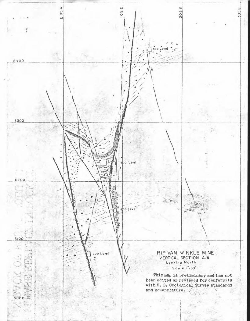
dropping the eastern side in step fault fashion (see section A-A).
This movement broke the main vein fissure sharply in the ground cut
by the southern part of the 500 level but to the north, where the main
vein is steeper, this movement apparently was taken up by the main vein
fault rather than by the branch slips.Jr - * - "* --'*&?»
Veins and faults that-dip steeply east follow the western limb : *
of the ̂ broken syncline. Tie "strong vein exposed in the southwestern
part of the 500 and 600 levels is'called the 600 vein and contributed
*much of the production dur;Lng 1941-42 About 70 feet above the 500$'-' :; , | , , '
level the 600 vein reverses its dip and feathers out just before reaching
a northeasterly dipping branch fault related to the late easterly dipping
main vfin branch faults (see section A-A and the geologic maps of thef --V.--, , . ~"
500 and 600 levels)! Below the 500 level this Vein extends to this fault
and there ends abruptly. On the crosscut to the 600 vein on the 500
level this fault is broken! by low-angle fractures that contain veinlets
of pyrite, sphalerite, and? carbonate, indicating that the fault is in
large part of premineral age (see sketch on geologic map of 500 level).
Ore localization. Although a minor amount of post-ore faulting
has taken place, the fracture pattern is believed to be essentially the
same n^w'as when mineralization took place. Most of the ore was

7..
deposited along the major faults vhere openings had been created \y
late pre-mineral movement. The open ground included the portions of
the main vein with a marked westerly dip lying between relatively strong
brittle walls. The clay shales yielded a tough impervious gouge that
discouraged ore deposition, but the silicified breccias, cherty shale,
and siliceous shale made favorable walls. Where movement took place
on several branch slips, as in the ground at the south end of the 500
level, a wide zone was opened up and replaceable beds locally became
permeable for some distance from the main fractures. In such areas I
metallization was more extensive than where the rock was less shattered,
and "blanket 11, or bedding plane ore formed in calcareous beds. Unfortu*
nately, most of the bedding plane ore found does not mill well and is
high in zinc.
A zone of gash veins in the hanging wall of an easterly dipping
main vein branch fault was productive between the 500 and 600 levels,i
and the ore found just north of the fault that terminates the 600
vein on the 600 level may thave formed in similar fractures in the
hanging wall of this fault, which seems to bend sharply north at its
junction with the 600 vein!.
;The tenor and width
Exploration
>f the veins change appreciably within a
short distance, and information on such changes in advance of drift- f ----- ;: - - 1 "" v - ; - ~
ing or sinking will greatly facilitate efficient exploration. For" 4 '- - :-":-- ; I .,-
this reason it is believed^desirable to drill a flat hole northeast
from near the sump of the 700 level to explore the gash vein zone that- ' :' .1 - ' ' ' - f .- / .- ..." carries good ore in the northeastern part of the 600 level.
S,
, The No. 1 drill hole of tfee U. S. Bureau of Mines cut a small^lead-f * ^ * «* «-*« ^ -* .~*-;*
zinc vein at 57 feet (see geologic map of the 600 level). The strike off . - "' ':-* -: " ' '
this vein is unknown, but it is most unlikely 'that the vein is the branch
from the 600 vein that diverges to the southwest at the winze. Long
hole drilling south of the winze seems to have established the course of
that branch vein as shown on the map. It would be desirable to know the
course of the new vein cut in the,No. 1 drill hole and something con
cerning changes in its tenor and width. This could be done by exploring
the area to the north of the No. 1 drill hole.
The workings north of the northwest branch fault, which cuts off
the ore in the 600 vein, do not follow this fault northwest. The writers
were unable ,to find convincing evidence of the course of the fault to
the northwest, but believe it turns northward where it intersects the
600 vein. However, it is possible that it continues northwest and that
it intersects other northerly trending veins. As it is a pre-mineral
fault that apparently caused ore to be localized in the 600 vein below
it, and as a zone of gash .veins was found just to the north of it, nearlyT 1
, in line with the 600 vein, it is believed there is a strong possibility
of ore, shoots near the intersection of any northerly veins with this
fault, if it continues its northwesterly course beyond its intersection
with the 600 vein.
the long "runaround11 crosscut that branches west from the 300 level. i , - "'- "-"--. - "..-.-".
" f .-' "- ~ -
120 feet south of the portal and rejoins the main haulage drift at the
underground shaft station was inaccessible in January, 1943. According" '* '.---' . " { ' : -..' '
to Mr.j Foster, it is in porphyry for the first 300 feet, beyond which it* >
was caved in 1939. The primary igneous structure in the porphyry exposed * - ~ -
in the; main drift suggests intrusion at a low angle; the meager exposures
.,;,,,> . 9.
^"' * » - » ** ' & ^
Vest of the main vein on the lover levels suggest that no large cross- * * ' - . * - :- ^' ~ * <* - , * . - --»
breaking mass of porphyry is present vest of the shaft; if the 300 level
"runarqund11 crosscut is largely in porphyry, as reported, this porphyry
probably is a sheet sub-parallel to the bedding of the shale. The atti-" ? ~ ". '*'-. ' - <r £ " r '- .-"'- ^' '- tude of the shale on.the western limo of the broken syncline, which
is the dominant structure of the mine, reverses from an east dip to a
vest dip about 40 feet vest of the. main vein on the 500 level. If this'- -."" " "?-.'- ' ..' >- _. . , '.
anticlinal structure is reflected in a porphyry sheet where replaceable
beds cut by mineralized fissures underlie it, conditions would be indi
cated suitable for bedding plane ore. Mineralized fissures and some
related bedding plane ore are exposed in the crosscut extending vest
from the shaft on the 500 level; thus, what evidence is available points
to the probable presence of conditions favorable to localization of some
blanket ore beneath porphyry in the northern part of the mine (see section
D-D)^" It is believed that exploration is warranted if directed toward
establishing the shape of the porphyry body in the northwestern part of^ ~.r- - -'.,- _ __ ^ i.^;:,".
the jJOO level and the presence of bedding ore below it if the body is a
Salt Lake City, Utah January 28, 1943
-1 « v - »' ' A u , " *
I
RIP VAN WINKLE MINE ; ' - VERTICAL SECT ION A-A
Looking N or thScole l"=50' '-<<*
This cap is preliminary and has not been edited or reviewed for conformity with U. S. Geological Survey standards and nomenclature. *-':'-' x '
;: <<..£,.-!
'pw- '..?. ^: ^'V.r . ' : - -. » . v._y- :..l

»
^ '
*
-f.-
*'
o^
O
., /
.,J -
/ J
7
,,,,
i ,
"'*R
IP
VA
N
W'N
KL
E
MIN
E
,, V
ER
TIC
AL
SE
CTI
ON
E
- E
<*.
L 00 k
ing
N
or't
h
Sc
o le
l"
s50'
This
map i
s preliminary and has not
been edited or
rev
iewe
d for co
nfor
mity
with U.
S. Geologi
cal ̂
Surv
ey sta
ndar
ds
and nomenclature*.
x?>
.""*
j.
*aj*__
_ - *

>cro Level ____
RIP VAN WINKLE MINE
VERTICAL SECTION B-BLooking North
Scole l"= 50*
This asap Is prelirafnary 8flc* h^s not been edited or reviewed for cotifoncity »IthU. S. Geological Survey standards and nomenclature.
6000

i - -. -- ?., , - -a* A /-. - = ~.-.-'^-*s t
,..R!P VAN WINKLE MINE --."VERTICAL SECTION D-D
Looking North
Sccle l" = 50* '
This map is preliminary and has not been edited or reviewed for conformity with U. S. Geological Survey standards and nomenclature.

RIP VAN WINKLE MINE VERTICAL SECTION C-C
LooklngNorth
Scale l"= 50'
^a w J preliminary and has edited or reviewed for conformity
with U. S. Geological Survey standards and nomenclature* ._