Embed Size (px)
Citation preview

Rhodes East - Social Infrastructure and Open Space Assessment
Final Report
Client: Roberts Day, on behalf of NSW Department of Planning & Environment
Date:
7 December 2016
Contact: Jenny Vozoff
[email protected] 02 9387 2600
Sydney
02 9387 2600
Level 6
332 – 342 Oxford Street
Bondi Junction NSW 2022
www.elton.com.au
[email protected] Sydney | Canberra | Darwin
ABN 56 003 853 101
Prepared by Jenny Vozoff
Reviewed by Chris Manning
Date 7 December 2016
Document name Social Infrastructure and Open Space Final Report 7 December 2016
Version Final v4

EXECUTIVE SUMMARY 1
1 INTRODUCTION 3
1.1 Precinct location and context 3
1.2 Precinct vision and objectives 4
2 PRECINCT PLANNING CONTEXT 6
2.1 Policy and planning context 6
2.2 Demographic context 21
2.2.1 Existing population 21
2.2.2 Future population 23
3 EXISTING SOCIAL INFRASTRUCTURE AND OPEN SPACE PROVISION 24
3.1.1 Regional level infrastructure 24
3.1.2 District and local level infrastructure 26
3.2 Open space and recreational facilities 30
3.3 Identified needs 31
4 FUTURE POPULATION AND PROFILE 33
4.1 The development scenario 33
4.2 Forecast dwelling yields and population 33
4.3 Demographic characteristics of future population 35
4.3.1 Characteristics of high density areas 35
4.3.2 Implications for the Rhodes East Precinct 36
5 COMMUNITY FACILITY REQUIREMENTS 38
5.1 Approach to planning social infrastructure 38
5.2 Local government community facilities 40
5.2.1 Community centres 40
5.2.2 Facilities and services for older people 44
5.2.3 Facilities for young people 44
5.2.4 Libraries and cultural facilities 44
5.3.1 Government schools 45
5.3.2 Higher education 46
5.3.3 Public health services 47
5.3.4 Emergency services 47
5.4 Private / non-government sector facilities 48
5.4.1 Neighbourhood shopping 48
5.4.2 Childcare facilities 48
5.4.3 Private schools 49
5.4.4 Medical services 49
Contents

5.4.5 Welfare and support services 50
5.4.6 Places of worship 50
5.5 Delivery of community facilities 50
5.6 Summary 51
6 OPEN SPACE AND RECREATIONAL REQUIREMENTS 52
6.1 Demand analysis 52
6.1.1 Trends in recreation and sport participation 52
6.1.2 Approaches to determining quantum of open space 54
6.1.3 Open space planning principles 55
6.2 Opportunities and constraints 56
6.3 Structure Plan 57
6.4 The quantum of open space 57
6.5 Requirements for active open space 58
6.6 Requirements for passive open space 61
6.6.1 Parks, plazas and linkages 61
6.6.2 Playgrounds 62
6.6.3 Activities for young people 62
6.7 Regional facilities 62
7 CONCLUSION 64
8 REFERENCES 69
APPENDICES
A Vision and principles for Rhodes Central 72
B Open space and recreational facility rates of provision 76
C Guiding principles for community facility provision 78
FIGURES
Figure 1 Context Map – Rhodes East Priority Investigation Area 4 Figure 2 Community facilities in Canada Bay 25 Figure 3 Structure Plan 34
TABLES
Table 1 City of Canada Bay Principles for Provision of Parks 9 Table 2 Open space issues in Rhodes Peninsula 15 Table 3 Schools near Rhodes East 28 Table 4 Childcare facilities in Rhodes, 2016 29 Table 5 Projected dwelling uplift – Rhodes East Urban Investigation Area 33 Table 6 Projected locational split of new Precinct population, 2036 35 Table 7 Projected dwelling yield and population by Character Area, 2036 35 Table 8 Typical standards for community facilities and open space 38 Table 9 Percentage of land area as open space in selected high density areas 55 Table 10 Open space planned for Rhodes East 57 Table 11 Recommended community facilities and open space for Rhodes East 65

Rhodes East - Social Infrastructure and Open Space Assessment Elton Consulting 1
This Social Infrastructure and Open Space Assessment, prepared by Elton Consulting, considers the
facilities and services that will be required to support population growth arising from future
development within the Rhodes East Priority Precinct Investigation Area. Rhodes East is one of a
number of precincts within the Sydney metropolitan area designated for housing densification around
transport hubs.
Relevant policies and objectives of the NSW Government and the City of Canada Bay Council have
been reviewed to provide the guiding framework for the planning and provision of community facilities
and open space.
The study presents an analysis of the social context of the Rhodes East Precinct and surrounding
areas. It examines characteristics of the existing population and also considers those of Rhodes West,
which has seen rapid growth and change over the past 10 years and provides useful insights into the
characteristics of people likely to move to the Rhodes East Precinct in the future.
The report then examines existing human services, community and recreational facilities and open
space in and around the Rhodes East Precinct and their capacity to absorb demand likely to be
generated by future residents. Social infrastructure within Rhodes East is relatively limited. The
Rhodes Community Centre on Blaxland Road is a heavily used, but dated facility with a range of
heritage constraints. A large new cultural and community precinct, known as The Connection, will
shortly open in Rhodes West. Rhodes West also contains a large commercial and retail centre and
several childcare centres. A wide range of other services and facilities are available in nearby centres
such as Concord, Burwood, Strathfield, Bicentennial Park and Sydney Olympic Park, which are easily
accessible by rail, bicycle and on foot. Concord’s facilities include schools, a library, community centre,
hospital, medical facilities and commercial areas. A proposed library, school and regional open spaces
are, or will soon be, located to the west in Wentworth Point and the Sydney Olympic Park precincts.
Key needs for the existing community include access to flexible meeting and activity spaces for a
range of purposes, indoor and outdoor places and spaces for large community or private gatherings,
local medical services such as doctors and allied health services and improved public transport. A
number of recently established childcare centres will address some pre-existing gaps in service
provision, and The Connection will provide much needed space for community activities for existing
residents and the new community in Rhodes East. However, additional services will be required by the
area’s growing population in future.
The study found that the Precinct has a good supply of open space and recent upgrades and
embellishments recommended in the Open Space Masterplan and Plan of Management (Corkery
2015a and 2015b) have now been completed. At the same time, sporting fields in the surrounding
area are already at capacity. Other open space and recreation needs include good quality walkways
and plazas where residents can walk, meet, access the waterfront, shops, food and activities, open
lawn areas and parks, barbeque and picnic facilities with good amenities, public toilets and signage.
On the basis of this assessment, new local services, facilities and quality open space will be required
to cater for the future population.
The Structure Plan for Rhodes, as detailed in the Urban Design Report prepared by RobertsDay,
envisages an additional 4,000 human scale, high density dwellings and around 9,100 new residents
across five distinct ‘character areas’. Characteristics of a population attracted to high density living
have been analysed and would be expected to include high proportions of well-educated young adults
working in professional occupations, households of generally only one or two people and low
Executive summary

2 Rhodes East - Social Infrastructure and Open Space Assessment Elton Consulting
proportions of families with school aged children and older people aged 65+. High density areas also
typically show high proportions of rental properties and high levels of cultural diversity.
The analysis suggests a range of social infrastructure should be provided to meet the needs generated
by the projected population growth in the Rhodes East Priority Investigation Area. The following
community facilities are recommended for inclusion within Rhodes East precinct:
» An expanded multi-purpose community centre (with an additional 546-1,065m2 floorspace) to be
provided as part of a heritage-sensitive redevelopment of the Rhodes Community Centre on
Blaxland Road, adjoining an active ‘green corner’ of mixed use and open space at the south
western corner of Denham Street and Cavell Avenue. This expanded facility would complement
and expand the range of community uses and spaces, and would operate in synergy with The
Connection in Rhodes West
» A primary school
» Convenience retail and specialty commercial venues where people can meet, eat, drink and relax
» 4 privately operated childcare centres (depending on size)
» Local medical centres.
Arrangements for the location, timing and delivery arrangements for the new local primary school
remain subject to ongoing discussions between DP&E and the Department of Education.
In terms of local open space and recreation facilities, this study has recognised that there are several
important challenges to providing additional areas of open space in this area, including fragmented
land ownership within the precinct, large areas of good quality open space within close proximity and
high costs of acquiring new open space. The Structure Plan instead adopts a model for open space
provision that focuses on creating new walkways and connections, linking local areas with the harbour
and parks, embellishing existing areas of open space and creating a high quality public domain. This
approach is supported by Council’s Open Space Masterplan and other policies and has been
successfully applied in other high density residential areas.
The Structure Plan allows for:
» 1.92 ha of new public open space, made up of redevelopment of Leeds Street foreshore to provide
a foreshore transit plaza (future Ferry Wharf) and destination retail and commercial activities,
expansion of King George V Park, enhancements to McIlwaine Park (including potentially breaking
down the barrier of Concord Road through construction of a station bridge), investment in
foreshore works and new facilities at Uhrs Point Reserve, foreshore resting areas and a continuous
foreshore access
» Secondary and internal green links and a high quality public domain via enhanced ‘Complete
Streets’, new streets, pedestrian connections, ‘Corners Strategy’, public art and placemaking
» Exploration of opportunities for development of a ‘river pool’
» Passive local open space embellished to a standard consistent with the range of passive
recreational activity needs of a high density population and the recommendations of Council’s
Open Space Masterplan.
The future community will also rely to some extent on existing open space and recreation facilities in
Rhodes West, Sydney Olympic Park, Concord, Burwood, Strathfield and the wider area for access to
regional open space, sporting fields, indoor sports courts, outdoor court complexes and aquatic
facilities. However, with population growth in surrounding areas, these facilities are reaching their
capacity the facilities proposed within this Structure Plan are needed to provide high quality public
spaces, places and connections to support this new population of Rhodes East.

Rhodes East - Social Infrastructure and Open Space Assessment Elton Consulting 3
This report has been prepared by Elton Consulting for Roberts Day, on behalf of NSW Department of
Planning & Environment (DP&E) as one of a number of technical studies to support investigations into
the future planning for Rhodes East. DP&E is working with the City of Canada Bay Council to prepare
a rezoning proposal for the 36ha site, following Council’s request for the site to be declared a Priority
Precinct.
Elton Consulting was engaged to prepare an assessment of the social infrastructure and open space
that would be required to support an increase in population associated with a potential rezoning of the
precinct. This report builds on an earlier Preliminary Report to:
» Review relevant social infrastructure and open space studies for Rhodes East and the City of
Canada Bay
» Document existing community facilities in and around the Rhodes East Precinct, their usage and
capacity, plans for new facilities and key issues in providing for future community needs
» Use broad population estimates implied by the Structure Plan to forecast the types of social
infrastructure and open space needs that would be generated
» Detail a plan for provision of social infrastructure and open space to meet identified needs, based
on existing facilities and capacity, accepted benchmarks and standards and advice from Council
and the Department of Education as to the preferred rates and methods of provision.
1.1 Precinct location and context
The Rhodes East Priority Investigation Area is bounded by the Parramatta River in the north, Brays
Bay in the East, Mary Street, Rhodes in the south and the Northern Rail Line / Blaxland Road, Rhodes
in the west, as shown in Figure 1 overleaf. Bisected by Concord Road, Rhodes East contains mainly
low density housing to the east of Concord Road and south of Leeds Street, and the Leeds Street
Industrial Area along the Parramatta River in the north. The train station, topography and waterfront
setting contribute to an area that is easily accessible by public transport, bicycle and on foot to many
established and emerging centres such as Concord, Burwood, Strathfield, Sydney Olympic Park,
Wentworth Point and Carter Street.
Until the 1970s, the Rhodes Peninsula was characterised by an industrial precinct to the west of the
railway line and in the southern section of the peninsula, an industrial area to the Peninsula’s north
east (Leeds Street Industrial Precinct) and a predominately residential area to the east.
Remediation and redevelopment of Rhodes West industrial areas over the past 20 years through
Sydney REP 29 (1999), the Draft Rhodes West Masterplan (2009) and the Rhodes West Development
Control Plan (DCP) (2015), has transformed the Peninsula physically and socially. Industrial sites have
been replaced with retail, commercial and high density transport oriented residential mixed-use
developments. In the past five years alone, more than 40 planning, community engagement, open
space and development projects have been delivered, involving Council, private sector developers and
other levels of government. Businesses include the Rhodes Waterside Shopping Centre, Rhodes
Corporate Park and smaller businesses, which together provide an estimated 8,000 jobs. A major new
cultural and community precinct in Rhodes West, known as The Connection, will open shortly to meet
the needs of residents from the area, and a large new indoor recreation and leisure facility is planned
to the west of Rhodes train station. The residential population in Rhodes West, including Liberty
1 Introduction

4 Rhodes East - Social Infrastructure and Open Space Assessment Elton Consulting
Grove, is currently around 14,000 people (City of Canada Bay website – The Rhodes Community; City
of Canada Bay, November 2012).
Figure 1 Context Map – Rhodes East Priority Precinct Investigation Area
Beyond the Peninsula’s boundaries, significant development is planned for Sydney Olympic Park,
Wentworth Point, Carter Street and Homebush, in Auburn LGA to the west, including large new
residential communities. Development has also been occurring along the northern foreshore of the
Parramatta River in Meadowbank and Ryde.
1.2 Precinct vision and objectives
The Vision and Objectives adopted to guide urban renewal of Rhodes East as proposed by Council
are:
Vision:
Rhodes East will be an exciting and vibrant place to live and work through the creation of a connected
and diverse community.
Objectives:
» Sustainability – A high-level of sustainability is to be achieved
» Transport - Prioritise walking, cycling and the use of public transport ahead of private vehicles
» Affordable Housing - Deliver a minimum 5% affordable housing for key workers in the area (note:
percentage to be tested through economic modelling)

Rhodes East - Social Infrastructure and Open Space Assessment Elton Consulting 5
» Human scale high-density development of 4-15 Storeys – achieve a significant increase in
residential density without the extensive need for high-towers (note: 4-15 storeys is based on
initial work of the Future Cities Collaborative and Council)
» Waterfront Access – Provide continuous public access to the Parramatta River foreshore.
Social infrastructure includes services and facilities such as schools, preschools and childcare, sports
and recreation, community centres and aged care facilities, as well as areas of open space and
walking / cycling connections.

6 Rhodes East - Social Infrastructure and Open Space Assessment Elton Consulting
This chapter examines the social policy and planning context of Rhodes East and the findings of
previous studies to assist in understanding the background against which the Precinct would be
planned and redeveloped. This includes a review of a demographic profile report of the existing
population of the Precinct, to understand the relevant social characteristics that may indicate existing
needs and social infrastructure demands.
2.1 Policy and planning context
Documents relating to Rhodes East have been prepared for a range of purposes in recent years,
including the development of Rhodes West (west of the railway line), planning for Rhodes Central
Urban Activation Precinct (UAP -the area between the railway line and Concord Road) and more
recently Rhodes East (east of the railway line).
Key policies, plans and studies relevant to an understanding of social infrastructure and open space
within and near the precinct are summarised below.
A Plan for Growing Sydney
Sydney’s Metropolitan Strategy, A Plan for Growing Sydney (NSW Government 2014), sets the overall
context for development within Sydney and contains a number of directions and actions aimed at
accelerating housing supply and improving housing choice in both urban renewal and greenfield
precincts. The Plan aims to reinvigorate key Sydney suburbs with a greater choice of homes linked to
improved public transport, and access to shops, restaurants, parks and education and health services.
The next stage in planning will be the preparation of individual subregional plans, in partnerships
between the State Government, Councils and the community. Subregional plans will link the strategic
directions of the Plan for Growing Sydney with more detailed planning controls for local areas.
The City of Canada Bay is located within the Central Subregion of Sydney, which is forecast to
increase from 819,400 to 1,086,250 residents between 2011 and 2031 – an increase of more than
266,000 people. It is estimated that this rate of population growth will require construction of 130,700
new homes in this 20 year timeframe.
Priorities for the Central Subregion relevant to Rhodes East include:
» A competitive economy
» Accelerate housing supply, choice and affordability and build great places to live
> Work with Councils to identify suitable locations for revitalised suburbs, new services, homes
and jobs close to transport
» Protect the natural environment and promote its sustainability and resilience
> Work with councils to:
– implement the Greater Sydney Local Land Service’s State Strategic Plan to guide natural
resource management
– protect the natural attributes and visual amenity of the coastline and enhance opportunities
for public access
– protect the health of waterways and aquatic habitats.
2 Precinct planning context

Rhodes East - Social Infrastructure and Open Space Assessment Elton Consulting 7
Rhodes is identified as a Strategic Centre with the following priorities:
» Work with council to protect capacity for long-term employment growth in Rhodes
» Work with council to provide capacity for additional mixed-use development in Rhodes including
offices, retail, services and housing
» Support health-related land uses and infrastructure around Concord Hospital
» Work with council to improve walking and cycling connections between Rhodes train station and
Concord Hospital
» Facilitate construction of a public transport, walking and cycling bridge over Homebush Bay to
connect Rhodes to Wentworth Point.
Futures Plan 20 Community Strategic Plan
FuturesPlan20 (FP20 – City of Canada Bay 2010) is the City of Canada Bay’s Community Strategic
Plan. The Plan sets out a community vision prepared as an input to Council’s Local Planning Strategy.
Engagement identified community values and priorities for the City around four key themes:
» Active and Vibrant – focusing on support for community health and wellbeing, places for
participation in sport and recreation, availability of community service needs, opportunities for
community connection, celebration of established and emerging community, cultural awareness
and support for the arts, culture and lifelong learning
» Sustainable Spaces and Places – focuses on protecting the environmental, cultural and social
values of open spaces and foreshore areas, protection and enhancement of biodiversity, support
for environmental sustainability, a safer community, enhancing community spaces and
infrastructure and sustainable design that conserves local heritage
» Innovative and Engaged – focuses on open communication and collaboration on local issues,
promoting local services and events, and innovation and good governance to meet community and
legislative expectations
» Thriving and Connected – focusing on support for a range of housing options, develop facilities to
promote walking and cycling, safe and accessible local footpaths and roads, public transport
options, support for local shopping centres, local employment, education and skills development,
maintenance of sustainable tourism destinations and support for large high quality, global standard
business parks and enterprises.
The values and aspirations reflected in the Plan are important in planning for a new community in
Rhodes East. They are consistent with the community feedback from a range of other consultations
held within the LGA.
Canada Bay Local Planning Strategy (LPS) 2010-2031
Canada Bay’s Local Planning Strategy (LPS) 2010 provides long term direction for the planning of
Canada Bay, to assist future decision-making in response to population growth and change. The
Strategy also ensures that Sydney-wide strategic plans and projects (such as infrastructure,
employment, housing) are incorporated into the Council’s planning decisions.
Sections relating to housing, employment and recreation and open space are directly relevant to the
Social Infrastructure and Open Space Assessment.
Housing
The LPS sets out ways in which the State Government housing objectives and targets can be achieved
within the City of Canada Bay to ensure there is housing choice so that there is an adequate supply
for families, for people with disabilities, and that priorities for affordability and the needs of the ageing
population are met. Forecasts for future housing demand and supply have been superseded by the

8 Rhodes East - Social Infrastructure and Open Space Assessment Elton Consulting
current plans for the rezoning of Rhodes East. However, the LPS sets out a range of objectives and
actions for housing in the LGA that are relevant to social planning for this area.
Objectives are to:
» Provide a broad mix of new housing
» Facilitate the provision of a greater share of low cost or affordable housing
» Support and revitalise traditional local centres.
Strategies to achieve these objectives include:
» Provide a mix of housing types over the short and medium term
» Provide a greater share of low cost and affordable housing
» Ensure an adequate supply of low cost housing in the private market
» Monitor and evaluate housing strategies
» Improve urban design.
Employment
The LPS addresses future employment needs and provision, as population growth creates demand for
a range of industries and commercial floorspace. In 2006, Rhodes had the highest employment
density in the LGA, with Rhodes Waterside Shopping Centre and commercial floorspace, Rhodes
Corporate Park and Leeds Street industrial zone. Future employment growth in the LGA is expected to
be concentrated in Rhodes, consistent with the Draft Inner West Sub-regional Strategy.
Broad employment objectives and those specific to Rhodes support the protection of some
employment lands and further development of employment opportunities in this area:
» Improve transport services and infrastructure and capitalise on opportunities for future transport
and road infrastructure upgrades
» Protect employment generating capacity and provide diverse opportunities for employment
» Retain industrial sites
» Support strategically positioned new and developing centres - including the development of Rhodes
as a specialist centre and economic driver for the LGA
» Encourage a diverse employment base
» Support home based businesses and support for start-ups.
Recreation and open space
Recreation and open space objectives across a range of government policies and plans aim to increase
participation in community activities, use of parks, sporting and recreational facilities and participation
in the arts and cultural activities.
Council’s provision of open space and recreational facilities are outlined according to a classification by
hierarchy and functions. Overall, the LGA contains more than 218ha of open space, or 3.32ha per
1,000 residents. Excluding the 40ha privately owned Concord Golf Course, the remaining 170ha is
distributed across local, district and regional parks, with the high proportion of regionally significant
open space due to several large foreshore and sports parts such as Majors Bay Reserve, Timbrell
Park, St Luke’s Park, Cintra Park and Queen Elizabeth Park. Almost two thirds of the open space is
within Concord Statistical Local Area (SLA), with the remainder in Drummoyne SLA.
The LPS lists Council’s recreational facilities and average population serviced by each facility (see
Appendix B). The LPS notes that while the overall rate of open space provision is close to the
generally accepted benchmark of 2.83ha/1,000 residents, it is important to take a range of other

Rhodes East - Social Infrastructure and Open Space Assessment Elton Consulting 9
factors into consideration when considering community needs. Open space adequacy issues were
examined in the City’s 2007 Recreation Plan which concluded that the quantity of open space was
adequate but only just so, “with little spare capacity to accommodate the additional open space needs
generated by new development” (p. 124). A range of issues were also raised in relation to the quality
and distribution of open space across the LGA. These included:
» Relatively high rates per capita of open space provided in Rhodes
» A perception of a lack of sporting and recreation facilities across the LGA
» A high proportion of small local parks
» Limited supply of natural areas
» Many sportsgrounds rated by user organisations as having poor quality turf, insufficient
floodlighting, poor to adequate amenities, floodlighting, kiosks etc.
Demand for active open space was seen as being particularly under pressure. Many sporting fields
and courts are being used at or above capacity in winter months (p. 125).
While population growth forecasts are now out of date, the LPS contains useful principles for future
provision of open space and recreational facilities, as shown in Table 1.
Table 1 City of Canada Bay Principles for Provision of Parks
Attribute Local Parks District Parks Town Parks
Function Accessible and close-to-
home (‘walk to’) recreation opportunities
in residential areas.
They are important for
most residents – but particularly for children,
the parents of children and older people
Larger, less accessible
(‘drive to’) parks providing for larger scale or specialist
recreation opportunities that
cannot be readily accommodated in small
local parks.
Provide rest / relaxation and
entertainment opportunities for workers, shoppers and
visitors to commercial/retail
centres
Catchment 1. Small local reserves
that provide for people
within immediately
adjacent areas -
probably within 200-300
metres walking distance
2. Larger neighbourhood
parks that may attract
users from surrounding
suburbs/areas (but still
usually within walking or
cycling distance).
Desirably within 2-3
kilometres of all households
Key uses The small reserves
provide short-term play
and rest opportunities
and landscape features,
primarily for local
residents.
As for larger local parks plus
longer-term activities –
family/group social
gatherings, picnicking,
walking/cycling
Greater range of facilities –
Range from small
landscaped squares to large
pedestrian malls

10 Rhodes East - Social Infrastructure and Open Space Assessment Elton Consulting
Attribute Local Parks District Parks Town Parks
The larger parks may
comprise more
comprehensive play equipment, more
significant landscape features (views,
significant vegetation etc) and linkages with
other open space.
playgrounds, nature walks,
cycle tracks, dog exercise
areas, walking circuits
Cultural & natural heritage
resources may be important
elements of district scale parks
Minimum
size
Parks should be at least
3,000m2 in size
Desirably three hectares or
more
Depends on size of town
centre
Generally aim to meet
minimum area requirement for local parks (3,000m2),
although smaller area can provide for basic recreation
such as seating and breakout spaces
Design and location
require-
ments
User friendly in terms of
attractiveness, diversity
of opportunity, perceived
safety, proximity to user
populations and
presence/ absence of
access barriers
Ideally, parks that combine a variety of
features and uses –
contact with nature, pleasant social settings,
children’s play, cultural interest and varied
topography.
As for local parks – but also large enough to
accommodate a much
greater variety of uses while protecting and enhancing
natural features, cultural heritage, views and/or
visually significant areas.
Generally hard landscaped rather than natural grass
Can incorporate seating,
toilets, paving and public art
Source: City of Canada Bay 2010, Table 6.10, p. 132 and 133
Open space linkages are a high priority, providing connectivity and adding value to the usability and
recreation potential for open spaces, as they offer opportunities for community participation in
walking, dog walking, cycling, jogging and skating. When vegetated, these areas can also provide
biodiversity benefits and areas for picnics and outdoor gatherings (City of Canada Bay 2010, p. 133).
While the total quantity of open space is an important consideration, this needs to be balanced by
other factors such as suitability and accessibility criteria.
Demands for future sports fields were estimated using participation rates for a range of sports by age
group. Again, while population estimates are dated, planning for future needs would adopt similar
planning principles.
Options considered to meet future demand across the LGA were found to include:
» More intensive use of existing space and facilities (where ‘spare capacity’ exists)
» The embellishment or expansion of existing spaces (to increase their carrying capacity)

Rhodes East - Social Infrastructure and Open Space Assessment Elton Consulting 11
» Synthetic conversions of sports field open space, and/or
» The acquisition of new open space and recreation facilities.
Council’s key principles and performance requirements for new open space to maintain existing
service levels to 2031, are summarised in the following Table from the LPS:
Calculations of notional open space requirements from forecast population growth and additional open
space needed to meet that demand are superseded by changes in population and dwelling forecasts,
including those for the Rhodes peninsula. These have been reviewed as part of the Structure Planning
for Rhodes East in discussions with Council officers and DP&E.
S94 Development Contributions Plan 2015
Social infrastructure
Council commissioned several studies to identify current and future (to 2031) community facility
needs, costs and strategies and directions to meet the future needs of the community. These include:
» A Community Facilities Resourcing Strategy (CRED 2011)
» A Cultural Plan and Public Art Strategy (adopted in 2007)
» Draft City of Canada Bay Cultural Facilities Report (2013).
Community facilities are currently provided at a floorspace rate of 162m2 per 1,000 residents.
“The CRED Community Facilities Resourcing Strategy 2011 concluded that there were many
deficiencies in the current provision of community facilities. There was no multi-purpose district

12 Rhodes East - Social Infrastructure and Open Space Assessment Elton Consulting
community centre or a youth centre, most of Council’s community venues were unstaffed community
halls, were single purpose facilities which are expensive to maintain, are not co-located with other
services and did not provide space for delivery of programs for young people” (p. 20).
Priorities for the provision of future Council operated facilities include:
» More strategically located facilities within activity hubs near commercial, retail and other
community activity
» Need to rationalise Council’s single purpose facilities and co-locate within activity hubs
» Provision of a range of spaces for older people
» More education and care places and family support programs and services
» Programs and services for young people close to public transport
» Increasing demand for indoor recreation facilities
» Community centres to build connections between new and existing community members.
In addition the Cultural Plan 2008-2013 and the draft Cultural Facilities Report 2013 identified the
need for:
» Purpose built infrastructure in key sites e.g. Cabarita Park Conservatory
» Community activity hubs to centralise cultural interaction in Concord/Strathfield, Five Dock and
Drummoyne
» Cultural programs in existing facilities
» Strategic partnerships for cultural facilities
» Art revitalisation and adaptive reuse of vacant properties.
The Plan specifically excludes the needs of the new population in Rhodes West which are dealt with in
a separate S94 Contributions Framework.
No community and cultural facilities identified in the S94 Contributions Plan are proposed for Rhodes
East.
Open space
Council’s S94 Contributions Plan notes that current rates of public open space provision are 2.6ha per
1,000 population (p. 6).
“Due to the unlikelihood of Council being able to purchase additional land for open space and
recreation facilities, development contributions are better spent on upgrading, rationalising and
increasing the capacity of existing infrastructure to better cater for the additional population”
(p. 6)
Amongst the nominated High Priority Open Space & Recreation Works to 2031, $500,000 is allocated
for a small skate park facility in Rhodes East in the long term. The location of this facility is shown as
being on the eastern side of Concord Road between Cropley and Llewellyn Streets.
Funds are also allocated to selectively redevelop some key spaces for social/family recreation for
people of all abilities and including teenagers and older adults. Funds are also allocated for re-
establishing bushland for passive open space, community gardens and foreshore environmental
works.
Off-leash dog areas (short-term) and off road trails (staged) are also included in the S94 Contributions
Plan and could potentially be incorporated into Rhodes East.

Rhodes East - Social Infrastructure and Open Space Assessment Elton Consulting 13
Rhodes Peninsula Place Plan 2012
Council’s Place Plan for the Rhodes Peninsula contains a community profile, outcomes of a detailed
community and stakeholder engagement process and an Action Plan for the provision of community
facilities, functions, activities and programs to meet community needs to 2022. The Plan draws heavily
on the community aspirations expressed by more than 800 stakeholder participants through survey,
focus group, Neighbour Day engagement and a stakeholder workshop. Participants were asked to
provide feedback on the social and physical infrastructure that could meet community development,
recreational, cultural, economic and community service needs, as the Peninsula continues to develop
and change. The Action Plan includes Council, key stakeholders and other delivery partners.
The placemaking model adopted for the Plan incorporates five attributes of place:
» Social and cultural life
» Uses and activities
» Comfort and image
» Connectivity
» Voice and influence.
Overarching themes from the engagement undertaken in developing the Place Plan were:
» Infrastructure that keeps up with demand
» The public domain needs to be kept clean and well maintained
» Rhodes Peninsula as a more active and vibrant place.
Some of the placemaking Actions identified are within Rhodes East, including landscaping, parking and
boat ramp works under John Whitton Bridge and road and footpath improvements. Others, while
referring to new facilities in Rhodes West, will be directly accessible to a new community in Rhodes
East, such as The Connection within the Community Precinct, Bennelong Bridge and works around
Rhodes Station.
Planning for future placemaking sets out a large number of specific actions for:
» The entire peninsula
» The Community Precinct
» The public domain, open space and foreshore areas
» Private and commercial space in strata buildings, the Business Park and the shopping centre.
The values expressed in the Place Plan are consistent with, and well integrated into Council’s plans
and policies, including recreation and open space planning, cultural planning and development, place
activation strategies and community development initiatives. Council aims to adopt this place planning
model in considering needs and planning for social infrastructure and open space facilities in Rhodes
East.
Recreation Facilities Strategy
The City of Canada Bay’s Recreation Facilities Strategy further examined demand and supply of
recreational facilities in 2013 to better understand the needs of its growing population and to provide
a framework for Council’s planning of recreational facilities. The Strategy is based on an assumption of
an additional 20,000 residents by 2031. Many of these new residents will live in medium and high
density housing, with implications for the availability of “private open space for physical and social
activity, as well as children’s play and pet exercise”.

14 Rhodes East - Social Infrastructure and Open Space Assessment Elton Consulting
The Strategy provides a full list of available recreational facilities and activities across the LGA and
specifies additional facilities likely to be required, together with an Action Plan and Principles to
prioritise the Actions.
Those specific to Rhodes include:
» “Liberty Grove – Rhodes will have the largest increase in demand within the City of Canada Bay by
2031 for off-road trails, and gym / fitness / dance / martial arts / gymnastics facilities” (p. 13)
» “Rhodes / Concord / Strathfield and Russell Lea areas were consistently less well served than other
areas of the City – largely because these areas lack large open spaces (which contain most of the
City’s recreation facilities)..” (p. 23)
» “Cabarita and Rhodes are outside 1km distance threshold of a public playing field” (p. 29)
» “Rhodes has very limited opportunities for residents to play soccer” …”Consider acquiring a 2-‐pitch
site in Rhodes east… Consider using a rooftop for futsal in Rhodes Business Park, or a floating
pontoon in Rhodes” (p. 31-32) “Consider partnering with the private sector to provide futsal.
Consideration should be given to providing indoor courts sports access to Rhodes residents. This
should be a minimum of two courts (netball sized courts)” (p. 56).
» “Consider providing a small skate facility in Rhodes East” (p. 40)
» “Provide a greater diversity of opportunities and landscape setting types in [social / family
recreation parks] open space in Rhodes” (p. 43)
» “Consider Rhodes … as priorities for provision of [children’s playground facilities in] social / family
recreation parks, as these are least well served” (p. 44)
» “Open space in Rhodes generally provides relatively low quality experiences because of the limited
size of parks, and where linear reserves are provided the diversity of opportunities and landscape
setting types is low” (p. 46)
» “Develop a community garden at Rhodes … if there is community support” (p. 47)
» “The Rhodes Peninsula Place Plan suggests ‘Identify a suitable location for a dog park/s or off
leash area/s within the next 5 years’ ” (p. 47)
» “Establish a Rhodes (Homebush Bay) to Olympic Park [cycling] circuit” (p. 49)
» “There will be demand for indoor sports facilities to be provided in the Rhodes community to
support an increased population of around 12,000 people. These facilities should reflect the
cultural diversity of the area” (p. 57)
» “The Community Survey identified that there were “not enough basketball courts in the area,
particularly Rhodes” (p. 58).
As the current Planning Proposal for the LGA envisages an increase in population of around 31,350
residents, additional facilities to those set out in the Strategy will need to be provided in accordance
with the Strategy’s principles.
Rhodes Peninsula Front Door 2 Foreshore Open Space Masterplan
This 2015 Plan “provides a vision for the design and management of public open space in response to
the needs of a changing community at Rhodes Peninsula” (p. 1). The Plan incorporated findings of a
broad community engagement program aimed at capturing “a good understanding of the aspirations,
concerns, needs and values of the local community and other relevant stakeholders” (p. 12).
Key design principles identified through the Masterplan are:
» A Peninsula of Places
» Visual Coherence in the Public Domain

Rhodes East - Social Infrastructure and Open Space Assessment Elton Consulting 15
» A Connected and Legible Open Space Network
» Community Engagement and Partnerships
» Sustainable Open Spaces.
The Principles recognise that there are significant limitations to acquiring additional areas for public
open space on the peninsula, so they instead aim to increase “the capacity of existing open spaces to
comfortably accommodate more users” (p. 18), create a distinct visual identity, connectivity between
open spaces and to be socially, environmentally and economically sustainable.
The Masterplan identifies areas of open space within Rhodes East and Rhodes West precincts and
provides a Concept Plan for each space, its amenities, uses, activities and relationships to adjoining
open spaces and urban uses1. Within Rhodes East the Masterplan provides a Concept Plan for:
» Mill Park and John Whitton Bridge Reserve
» Uhrs Point Reserve and King George V Reserve
» McIlwaine Park and Churchill Tucker Reserve
» Brays Bay Reserve
» Rhodes Park and Lovedale Place Reserve
» Cropley Street Reserve and Cavell Avenue Landscape Area.
None of these parks have outstanding playground equipment upgrades as part of Council’s Let’s Play:
providing outdoor playgrounds for families in the City of Canada Bay 2008.
Much of McIllwaine Park, and Brays Bay Reserve, Rhodes Park and Lovedale Place Reserve are
outside the Investigation Area for this project.
Rhodes Peninsula Open Space Plan of Management
This Plan guides the management and use of open space across the peninsula in a flexible and
balanced way to meet the values, needs and opportunities of the local community, people working in
the area and visitors into the future.
The vision of the Plan of Management is to create “an engaging, legible and sustainable network of
public spaces extending from front door to foreshore, offering a diverse range of experiences and
uses with strong physical and ecological connections” (p. ii).
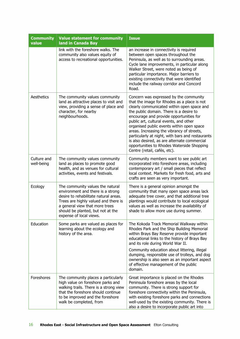
Key issues for open space management relevant to the Social Infrastructure and Open Space
assessment include:
Table 2 Open space issues in Rhodes Peninsula
Community
value
Value statement for community
land in Canada Bay Issue
Access The community places a high value
on the ease of access to community
land, regardless of age or physical ability, and expects parks to avoid
areas that permanently alienate members of the public. There is a
desire for a network of local paths to
Pedestrian connectivity within Rhodes
Peninsula, including along its foreshore, is
commonly desired by the community. Several areas within and between open space do not
currently permit easy pedestrian movement. Many people are encouraged by the current
bicycle facilities although most consider that
1 Note that some place names for parks and foreshore areas have been recently updated or renamed since the Open Space Plan of Management and the Front Door to Foreshore Plans were released.
16 Rhodes East - Social Infrastructure and Open Space Assessment Elton Consulting
Community
value
Value statement for community
land in Canada Bay Issue
link with the foreshore walks. The
community also values equity of access to recreational opportunities.
an increase in connectivity is required
between open spaces throughout the Peninsula, as well as to surrounding areas.
Cycle lane improvements, in particular along Walker Street, were noted as being of
particular importance. Major barriers to existing connectivity that were identified
include the railway corridor and Concord
Road.
Aesthetics The community values community
land as attractive places to visit and view, providing a sense of place and
character, for nearby neighbourhoods.
Concern was expressed by the community
that the image for Rhodes as a place is not clearly communicated within open space and
the public domain. There is a desire to encourage and provide opportunities for
public art, cultural events, and other
organised public events within open space areas. Increasing the vibrancy of streets,
particularly at night, with bars and restaurants is also desired, as are alternate commercial
opportunities to Rhodes Waterside Shopping Centre (retail, cafés, etc).
Culture and well-being
The community values community land as places to promote good
health, and as venues for cultural
activities, events and festivals.
Community members want to see public art incorporated into foreshore areas, including
contemporary art / small pieces that reflect
local context. Markets for fresh food, arts and crafts are seen as very important.
Ecology The community values the natural
environment and there is a strong
desire to rehabilitate natural areas. Trees are highly valued and there is
a general view that more trees
should be planted, but not at the expense of local views.
There is a general opinion amongst the
community that many open space areas lack
adequate tree cover, and that additional tree plantings would contribute to local ecological
values as well as increase the availability of
shade to allow more use during summer.
Education Some parks are valued as places for
learning about the ecology and
history of the area.
The Kokoda Track Memorial Walkway within
Rhodes Park and the Ship Building Memorial
within Brays Bay Reserve provide important educational links to the history of Brays Bay
and its role during World War II.
Community education about littering, illegal dumping, responsible use of trolleys, and dog
ownership is also seen as an important aspect
of effective management of the public domain.
Foreshores The community places a particularly
high value on foreshore parks and
walking trails. There is a strong view that the foreshore should continue
to be improved and the foreshore
walk be completed, from
Great importance is placed on the Rhodes
Peninsula foreshore areas by the local
community. There is strong support for foreshore connectivity within the Peninsula,
with existing foreshore parks and connections
well-used by the existing community. There is also a desire to incorporate public art into

Rhodes East - Social Infrastructure and Open Space Assessment Elton Consulting 17
Community
value
Value statement for community
land in Canada Bay Issue
Drummoyne to Olympic Park. foreshore areas, such as contemporary art /
small pieces that consider local context.
Heritage Some parks are valued as places
containing visual and social links to earlier times. There is a community
desire to identify and conserve areas of heritage significance.
The community values heritage interpretation
in parks and open spaces, and considers the
Armory Wharf Café at Newington in Sydney
Olympic Park as a good example. Other
suggestions include public art that reflects local context and historical values
Maintenance The community values community
land that is well maintained.
The community would like to see an increase
in the regularity and better coordination of
Council’s waste management, street maintenance, grass cutting and weed removal
services. The provision of more rubbish bins
in public streets and parks was identified by the community as being required. Other
maintenance related concerns included more prompt removal of graffiti and abandoned
cars, and the provision of dog tidy facilities in public streets and parks.
Partnerships The community values an ability to have a say and be involved in the
future of community land.
Opportunities for intergenerational and cross cultural engagement / participation in public
art projects should be investigated.
Recreation The community values the wide
range of quality recreation and
leisure experiences offered on community land. However, there is a
desire for more park facilities, new and/or upgraded facilities (such as
picnic facilities in district parks),
more walking tracks and bike paths, and year-round swimming.
Community needs for sporting and recreation
facilities, BBQ areas and public toilets are not
considered to be very well met at present. There is a strong desire within the community
to improve recreation facilities and amenity values within existing open spaces by
increasing BBQ and picnic facilities, public
toilet facilities, shade and seating opportunities, and bicycle parking for open
space users, as well as providing dog off-leash areas and community gardens.
Suggested locations for off-leash dog areas
include Rhodes Foreshore Park and King George V Reserve. Other facilities identified
as needed by the community include water features for children’s play as well as mobile
food services in Rhodes Foreshore Park and Rhodes Waterside Park.
Social The parks are valued as places for people to meet. Well maintained,
non-threatening parks are
appreciated as venues for family gatherings.
Many community members want to see a mix of programs within open space areas,
including recreational, educational and
cultural opportunities, to create a more engaging Rhodes Peninsula. A number of
open space areas within the Peninsula are currently underused and require a program of
additional facilities and recreation
opportunities. Provision of amenities such as BBQ/picnic facilities, seating with shade and

18 Rhodes East - Social Infrastructure and Open Space Assessment Elton Consulting
Community
value
Value statement for community
land in Canada Bay Issue
public toilets within open spaces were
commonly identified in the surveys as being required by the community. The development
of markets that sell fresh food, as well as arts and crafts was identified as very desirable to
facilitate social interaction within the community.
Corkery Consulting 2015b
Peninsula-wide strategies include:
» An emphasis on circulation and wayfinding – developing a legible and visually cohesive public
domain with safe and enjoyable access to open space facilities and activities, to contribute to
community health and well-being. Objectives are:
> To improve pedestrian and cycle access and circulation to and between existing open spaces
> To provide an integrated network of shared use paths, pedestrian-only paths and cycle lanes to
maximise access and circulation throughout the Peninsula
> To provide improved waterfront access where appropriate
> To establish regional connections to surrounding areas, particularly with Bicentennial Park,
Wentworth Point and Meadowbank via Meadowbank Railway Bridge.
» A Peninsula urban mesh is proposed to improve access and circulation through the peninsula
including in east-west direction across the railway line and across Concord Road.
» Continuous pedestrian / cycle connection along the northern foreshore, including:
> Extension of the Kokoda Track Memorial Walkway from Brays Bay Reserve through Churchill
Tucker Reserve to create the Pacific Campaign Walk (Corkery 2015b, p. 31).
Plans of Management (PoM) for each area of open space are proposed for implementation over a 15
year timeframe. A coherent public domain image, visual connections and ‘urban forest’ principles also
underpin the PoM for each area of open space within the study area.
Plans for Uhrs Point Reserve / King George V and for McIlwaine Park and Churchill Tucker Reserve are
of greatest significance for the Rhodes East Priority Investigation Area:
» McIlwaine Park + Churchill Tucker Reserve
McIlwaine Park is a large waterfront park to the east of Concord Road and a short distance from
Rhodes railway station. Churchill Tucker Reserve lies between McIlwaine Park and the station.
The southern portion of McIlwaine Park contains the northern section part of the Kokoda Track
Memorial Walkway, which extends southwards through Brays Bay Reserve. The Plan of
Management for McIlwaine Park includes creating a westward extension to the Kokoda Track
Memorial Walkway, to be known as the Pacific Campaign Walk. The Pacific Campaign Walk will
complement the existing Kokoda Track Memorial Walkway by commemorating ex-servicemen and
women with a focus on Australia’s involvement in the Pacific War.
The Pacific Campaign Walk would connect through Churchill Tucker Reserve to the railway station
via a new pedestrian plaza / bridge. The proposed Pacific Campaign Walk will encourage
movement from the station towards the foreshore and Brays Bay Reserve. A new plaza at the
southern end of McIlwaine Park, adjoining Brays Bay Reserve, would incorporate a boardwalk,

Rhodes East - Social Infrastructure and Open Space Assessment Elton Consulting 19
planting, shelters, paving and seating. In this area, the Kokoda Track Memorial Walkway would
also be realigned.
Further north within McIlwaine Park new BBQ and picnic facilities are proposed, as well as paths,
an exercise station, a foreshore promenade, central and norther pedestrian nodes, an over water
deck and a large dog off-leash area.
» Uhrs Point Reserve + King George Reserve
The Plan of Management aims to integrate these two adjacent reserves and improve the quality of
open spaces in the northern part of Rhodes East Precinct. A new waterfront pedestrian plaza is
proposed to pass through Uhrs Point Reserve and under Uhrs Point bridge. This would form part of
the Parramatta River Loop. New water access is proposed for the for Sea Scouts and Dragon Boats
areas via a new boardwalk with boat launching and recovery facilities.
The western part of Uhrs Point Reserve includes plans for a waterfront pedestrian plaza and tiered
slope, providing seating and recreational opportunities. New carparking facilities are also
envisaged.
Llewellyn Street would also support additional waterfront pedestrian and cycle connections.
Plans for King George V Reserve would include a fenced dog off-leash area and additional picnic
facilities, seating and shelter. This improved open space is adjacent to St Mary’s Multi-cultural Day
Care centre.
Riverside Scoping Study Report (City of Canada Bay 2012)
This study provides information to assist in re-interpreting the history, cultural, economic and
environmental heritage importance of the Parramatta River foreshore – identifying sites and stories
contributing to life and development of the southern foreshore of this regional waterway. Key aspects
and sites identified will contribute to future projects to support interpretation, understanding and
cultural research for the community. Themes include circulation and connections, water access and
experience, delivering public art that integrates with the foreshore environment and context, and
understanding and interpretation of the many layers of cultural heritage and development.
Within Rhodes Peninsula East, Rhodes Park and Kokoda Lovedale Reserve are identified are having
particular significance and a range of cultural layers and opportunities. Neither of these parks is
situated within the Rhodes East Precinct. Further opportunities are identified within existing and
planned parks in Rhodes West.
Community Safety and Crime Prevention Plan 2014-2018
This plan aims to continue work to improve the safety of the LGA, which, despite its size, traffic and
population growth, has seen a reduction in key crimes to low levels. Priority areas for crime reduction
include identity fraud, theft from retail stores, stealing from motor vehicle and graffiti.
Strategies to achieve these aims include Council and the Community Safety Precinct Committee
working collaboratively with Burwood Council, NSW Police (Burwood Local Area Command),
Commonwealth agencies, local businesses, residents and community groups across a range of issues,
continuing to support the Licensing Accord, rapid graffiti removal, and CPTED and planning initiatives
to prevent and reduce crime.
City of Canada Bay Cultural Plan
Council’s Cultural Plan takes a place management approach to fostering cultural development within
its growing and changing community in and around the LGA. Cultural development through place
management allows a focus on “history and heritage, stories, people, landscape, streetscape and
culture. It is about discovering what makes a place distinctive, authentic, and memorable” for
individuals and the community (p. 4).

20 Rhodes East - Social Infrastructure and Open Space Assessment Elton Consulting
Through this approach, Council aims to:
» Establish productive partnerships and links to the many cultural facilities and attractions
» ‘Turn its spaces into places’ so people will stop and become involved
» Encourage residents to experience and appreciate the area’s cultural and environmental diversity
and through this, develop a greater sense of belonging.
The Plan sets out the infrastructure, support and linkages necessary to achieve these aims.
In addition to growing numbers of residents, the City is attracting a new generation of workers in
creative and knowledge-based industries who also contribute to new demands for cultural and place-
based services and attractions.
Rhodes is identified as an emerging centre and one of the LGA’s activity hubs, where opportunities for
cultural activities and place making are being realised through a range of strategies and directions. In
Rhodes, these include development of ‘The Connection’, informal cultural activities and galleries,
markets, cafés, wireless services, wet-dry workshop spaces, digital displays, performance spaces and
improved street-life and public art. These provide a template for future development of activity hubs
that support community interaction. Rhodes Community Precinct will have a variety of facilities to
attract visitors and encourage community interaction.
Rhodes Peninsula Arts Plan
This Plan, adopted in 2012, provides a framework to encourage high quality public art to 2020 that
will “energise the public domain, recall local heritage, connect with the river and its moods and be an
integral part of the design…” (p. 3). The public art plan will aim to resonate with locals and visitors,
encourage an engaged interest in place and become, over time, a marker of community life. It will
also respond to the cultural diversity of Rhodes and reflects Council’s belief that “the urban
environment should be a place of lively, representative cultural identity” (p. 3).
The Plan sets out principles of public art and reflects many of the themes, values and aspirations that
have been consistently raised in community feedback about the future of the peninsula.
Opportunities for projects within Rhodes East include:
» Riverlights and other art works under the John Whitton Bridge
» A Living Memory project that incorporates several new artworks near the Kokoda Track Memorial
Walkway in Brays Bay Reserve and across Mary Street East, towards Rhodes Railway Station.
» There are also other opportunities such as water trails along cycleways through Rhodes East and
street art in new public areas. Some would be provided by Council with others funded through
developer contributions.
Rhodes Central Urban Activation Precinct Submission
The Rhodes Central Urban Activation Precinct (UAP) Submission was prepared by the City of Canada
Bay to seek formal nomination of this area as a (UAP) by DP&E. Rhodes Central is the portion of the
peninsula which lies between the railway line and Concord Road. The Submission includes background
information about the precinct and proposes a vision and principles for a sustainable community that
could apply, or be adapted, to Rhodes East (see Appendix A).
Future City Report
The City of Canada Bay has been working with the Future Cities Program on developing opportunities
for Rhodes Central, the area between the railway line and Concord Road.
Future City Report (Future Cities Program 2014) proposes and tests opportunities for an ‘Innovation
Scenario’ for the Rhodes Central Precinct which includes 2,891 residential dwellings and a mix of

Rhodes East - Social Infrastructure and Open Space Assessment Elton Consulting 21
commercial, retail, community uses and open space, including the possibility of a school on the
northern foreshore.
Following a planning workshop, the Key Strategic Priorities adopted by the City of Canada Bay Council
for the Rhodes Central precinct (excluding land east of Concord Road) are shown below:
2.2 Demographic context
2.2.1 Existing population
Rhodes Peninsula
In 2011, Rhodes Peninsula had an estimated resident population of approximately 7,727 people, just
over double its 3,844 residents in 2006, and around 10% of Council’s 80,065 residents. The
Peninsula’s western precinct was characterised by a predominance of high density apartment living,
and these residents made up 90% of the Rhodes peninsula population. At the time of the census, the
Rhodes peninsula as a whole was characterised by:
» A large working age population with a relatively high income profile
» A very high proportion of tertiary students
» A predominance of couple families – including a mix of couples without children (including empty
nesters) and couples with children
» Similar proportions of very young children (0-4 years) as the LGA and surrounding areas (except
when compared with Liberty Grove which has a higher proportion of children in this age group)
» A low proportion of people aged 55+
» A very high proportion of group households
Source: Extracts from City of Canada Bay Presentation Panel, 2014

22 Rhodes East - Social Infrastructure and Open Space Assessment Elton Consulting
» A very high proportion of people from culturally and linguistically diverse backgrounds – with very
high proportions of people who were born overseas, and who speak a language other than English
at home. The most commonly spoken languages other than English were Korean, Mandarin,
Cantonese and Hindi.
» A relatively low proportion of people who own their home outright, and a very high proportion who
are renting their home.
» A comparable rate of home purchase to the City of Canada Bay and wider areas, however a
considerably higher rate of households whose mortgage repayments are more than 30% of their
household income.
» A very high rate of internet connectivity (City of Canada Bay, 2012).
Rhodes East
A DP&E analysis of 2011 Australian Bureau of Statistics (ABS) Census of Population and Housing data
(November 2015) shows the Rhodes East precinct contained only around 10% (or 733) of the
Peninsula’s 7,727 residents in 2011. Of the 274 private dwellings in Rhodes East, 76% were separate
houses and 24% were semi-detached, terraces or townhouses. This area currently contains no flats or
apartments.
On average, residents of Rhodes East are older (42.5 years) than those of Rhodes as a whole (28
years), the LGA (37.1 years) and Sydney overall (35.7 years). The local population has a relatively
large proportion of residents aged over 40 years, in part attributable to an aged care facility (Concord
Community Hostel on Cavell Avenue, Rhodes, has 62 low care beds).
Other key characteristics of the Rhodes East population and housing in 2011 include:
» A similar proportion of the population born in Australia (62%) and born overseas (38%) as in
Canada Bay LGA and Sydney as a whole. The most common countries of origin for overseas born
residents were China (6.3%), South Korea (3.9%) and England (3.6%)
» A slightly lower proportion of residents completed year 10 or higher (86%), than in the LGA (89%)
and Sydney (88%). Rates of post-school qualifications (57.5%) are slightly above those for Sydney
(54.9%) but slightly lower than the Canada Bay average (61.6%)
» Labour force participation rates were slightly lower in Rhodes East (63%) than in the LGA (69%)
and Sydney (66%), partly attributable to the older median age of residents. For those in the labour
force, the unemployment rate in Rhodes East was low (3%) compared with the LGA (4.3%) and
Sydney (5.7%). The top industries of employment of residents were Retail Trade (12.2%), Health
Care and Social Assistance (11.4%) and Professional, Scientific and Technical Services (11.1%)
» While the majority of residents of Rhodes East drive to work (59%), this rate is well below the LGA
and Sydney averages of 68%). In Rhodes East, a high proportion of residents (27%) travel to work
by train (compared with 14% in the LGA and 17% in Sydney) and by walking (9% compared with
3% in the LGA and 5% in Sydney). By contrast, only 2% of Rhodes East residents travelled to
work by bus (10% in the LGA and 7% in Sydney). Rhodes East has a relatively high proportion of
residents with two or more motor vehicles (46% in the LGA and 48% in Sydney).
» Household types in Rhodes East were similar to those of Sydney as a whole, with 37% being
couples with children, 22% being couples without children, 20% lone person households and 9%
single parent households. Compared with the LGA, there was a higher proportion of couples with
children and ‘multiple and other’ households and a lower proportion of couple only and lone person
households in Rhodes East.
» The average household size in Rhodes East was 2.67 persons, compared with 2.55 for the LGA and
2.69 for Sydney.

Rhodes East - Social Infrastructure and Open Space Assessment Elton Consulting 23
» The area had a relatively high proportion of dwellings owned outright (70%) and relatively fewer
rented (30%) than the LGA and Sydney.
» Median weekly household incomes were similar to the LGA average and above those for Sydney.
Nevertheless, more than 37% of families were classed as experiencing housing stress, which was
slightly above the rate for Sydney as a whole and well above the Canada Bay rate of 27.2%.
The demographic data is, however, dated, due to it being from the 2011 census and the rapid
population growth that has occurred in Rhodes West since that time.
A better understanding of the demographic context will be available in early 2017, when results from
the 2016 census are available.
2.2.2 Future population
Population projections are provided for the Canada Bay LGA as a whole. These indicate an expected
increase of 31,300 residents between 2011 and 2031, to 111,350 people. These projections are
considered by Council to be conservative. More than half of the increase is expected to be attributable
to natural increase and much of this increase will be in older aged groups. For example, the
population aged over 65 is expected to increase by 77% while the 0-14 age group is expected to
increase by 43% and the 15-64 year age group is expected to increase by 31% by 2031.
Source: DP&E 2015
Forecasts prepared by forecast.id for the City of Canada Bay and Rhodes include development plans
for Rhodes West, but do not yet factor in the potential for large-scale redevelopment of Rhodes East.
Under current forecasts, Rhodes as a whole is expected to reach a population of 20,040, and the City
of Canada Bay would reach a population of 115,523 in 2031. This population forecast is based on
assumptions of future residential development in Rhodes reaching 8,868 dwellings in total, primarily
within Rhodes West, with only minimal infill redevelopment expected in Rhodes East.
Plans for the rezoning of Rhodes East will further increase the total population and dwelling stock for
the peninsula as whole.

24 Rhodes East - Social Infrastructure and Open Space Assessment Elton Consulting
This chapter considers the provision of existing and planned key social infrastructure, in and around
the Rhodes East Priority Precinct Investigation Area, which currently meets, or in future could address,
some of the needs of the future new population.
Community facilities within Rhodes and across the LGA are provided by the City of Canada Bay Council
and other (private and non-government) agencies. Council’s website and other sources have been
examined to identify locations and functions of existing facilities (see Figure 2 overleaf). The following
sections provide a summary of those nearest Rhodes East.
Existing social infrastructure has been considered in terms of its place within a hierarchy which
includes regional infrastructure (major facilities and services serving an LGA or broader metropolitan
region), district facilities (serving a number of suburbs) and local facilities (serving their immediate
surrounding, local community.
3.1.1 Regional level infrastructure
Health facilities
The Rhodes East precinct is located within the Sydney Local Health District (LHD). The nearest tertiary
level hospital is the Concord Repatriation General Hospital, just beyond the precinct boundary to the
south-east. Concord Repatriation General Hospital is a 750 bed facility for the inner west community,
and has teaching affiliations with the University of Sydney. Once primarily a hospital focusing on
caring for war veterans, the hospital now services the local communities of Concord and beyond. A
masterplan is being prepared for the Hospital, as described in Section 5.3.3.
The Concord Centre for Mental Health is a modern purpose-built facility attached to Concord Hospital
for patients needing specialist psychiatric inpatient care. Rivendell Child, Adolescent and Family Unit is
a mental health facility within the grounds of Concord Hospital’s heritage listed Thomas Walker
Convalescent Hospital building that specialises in the problems of young people and operates as part
of Concord Hospital’s Concord Centre for Mental Health.
Private hospitals are located nearby in Concord, Strathfield and Putney.
The nearest community health centres are located outside the LGA, in Ryde.
Cultural facilities
There are no large, regional level cultural facilities (galleries, performance or entertainment venues) in
the Rhodes East precinct. The nearest large scale entertainment venues are located at Sydney
Olympic Park (ANZ Stadium, Allphones Arena, Sydney Showground), as well as in Parramatta and
Sydney’s inner west and CBD. Also missing from Rhodes are studio spaces for artists or exhibition
areas to display works.
The new cultural and community precinct in Rhodes West, ‘The Connection’, will offer some spaces for
performances and cultural expression in its multi-purpose auditorium hall and creative studios. Public
art is being incorporated into particular areas of open space in accordance with Council placemaking
plans and policies. For example, internal and external spaces within The Connection are joined by a
large public artwork.
3 Existing social infrastructure and open space provision

0 500 1000 m
Figure 2 Social infrastructure and open space near Rhodes East
ELTON CONSULTING
OPEN SPACEF1 Sydney Olympic ParkF2 George Kendall Riverside ParkF3 Mill Park and John Whitton Bridge Park F4 Meadowbank ParkF5 Memorial ParkF6 Uhrs Point ReserveF7 King George ParkF8 McIlwaine Park F9 Brays Bay Reserve F10 Rhodes ParkF11 Churchill Tucker ReserveF12 Lovedale Place Reserve F13 Peg Paterson Park
Source: Google Maps, internet searches and community directories
B1
D3
B2A3
B3
B4
D2 B5
B6
B7
F3
F4 F5
F6
F7
F8
F9
F10
F11
F12
F13
E1
E2
E3
E4
E5
E6
E7
E9
E10
E11
E12
D4
E8
D5
C1
C2
C3
C4
C5
RETAIL / BUSINESS PARKA1 Rhodes shopping centreA2 Rhodes Business ParkA3 Newington Business Park
EDUCATIONAL INSTITUTIONSB1 Meadowbank TAFE and LibraryB2 Newington Public SchoolB3 Italian bi-lingual SchoolB4 Meadowbank Primary SchoolB5 Ryde Public SchoolB6 Concord West Public SchoolB7 Rivendell
EMERGENCY SERVICES / MEDICALC1 Rhodes Fire StationC2 My Health Medical CentreC3 Rhodes Family Practice C4 Concord Repatriation General Hospital C5 Thomas Walker Hospital
COMMUNITY FACILITIESD1 Newington LibraryD2 Ryde LibraryD3 Rhodes Community CentreD4 The Connection, Rhodes
Community PrecinctD5 1st Yaralla Sea Scout Hall
CHILDCAREE1 Concord West Long Day CareE2 Concord West Playgroup
Concord Uniting ChurchE3 Concord West /
Rhodes PreschoolE4 Dreamtree Family Day CareE5 Kids @ Weldon Concord West
Middle Childhood ServicesE6 Learn and Play
Children’s CentreE7 Only About Children – Rhodes
Corporate Park Child Care Centre
E8 Rhodes Central Pre School Kindergarten
E9 Rhodes Children’s CentreE10 Rhodes Family Day CareE11 St Mary Multicultural
Child Care CentreE12 Rhodes Threebees
Family Day Care
PutneyWentworth
Point
Melrose Park
Meadowbank
Concord West
Concord Road
Victoria Road
Hom
ebus
h Ba
y D
rive
A1
A2
F1
D1
F2

26 Rhodes East - Social Infrastructure and Open Space Assessment Elton Consulting
A selection of entertainment and leisure facilities such as clubs, pubs, bars, restaurants and cinemas
are located in Rhodes West. A few cafes in Rhodes East serve existing employment and residential
populations, although more variety is available in Concord, North Strathfield, Ryde and Sydney
Olympic Park. These facilities will all be available to new residents at Rhodes East.
Tertiary education facilities
Two TAFE facilities are located within a few kilometres to the north-east of the precinct:
» Northern Suburbs Institute (NSI) of TAFE, Meadowbank campus
» Northern Suburbs Institute (NSI) of TAFE, Ryde campus
Macquarie University is around 7.5 kilometres to the north-east and Western Sydney University’s new
Parramatta CBD campus is around 12 kilometres to the west.
Council has reported that there is a heavy, and increasing, demand for adult education services within
the existing population. In addition, demands are being placed on existing learning facilities from older
residents seeking to remain active. There are no community or adult education centres near Rhodes.
Residents would need to travel to Newtown, Carlingford, Parramatta or elsewhere to attend classes.
However, some on-line or face to face courses may be offered locally within existing community
facilities during the day or evenings.
Emergency and justice services
Rhodes Fire Station is a volunteer (retained) facility located within the Rhodes East precinct.
Rhodes lies within the Burwood Local Area Command (LAC) for Police services. The City of Canada
Bay works closely with Burwood Council and Burwood LAC in relation to community safety issues.
However, Burwood Police Station is around 7 kilometres to the south. The nearest police station and
local courthouse are on Victoria Road, Ryde – 3 kilometres to the north across Parramatta River.
The nearest ambulance station is on Denistone Road, Ryde.
3.1.2 District and local level infrastructure
Community centres and libraries
Rhodes East contains the Rhodes Community Centre on Blaxland Road. This former primary school
has two large rooms, a kitchen, toilets, parking and air conditioning and is available for uses such as
meetings, training, information sessions and private functions. It is a very well used, but older style,
facility, with limitations such as outdated kitchen, toilets and air conditioning, and very limited storage
space. It is understood to have a local heritage listing.
The Kokoda Education Centre is a Council owned community facility in Rhodes Park (beyond the study
area boundary) that offers spaces for hire. The facility is managed by the Kokoda Memorial Walkway
Board. This is also heavily used at peak times and lacks storage space. In addition, Kokoda Education
Centre and Walkway is a nationally significant space that is heavily used by students and for
commemorative events. Shared use would need to be negotiated with the RSL and is considered
impractical.
There is also a community centre at Gipps Street, Concord, with seating for around 250 people.
Demands for community meeting spaces are also met by a range of church halls and other spaces.
Rhodes East currently contains two formal places of worship: the prominent St. Mary & St. Merkorious
Coptic Orthodox Church is located on Cavell Avenue, while the Cornerstone Presbyterian Community
Church operates from the Rhodes Community Centre on Blaxland Road. However, it is understood
that there are a number of groups, including churches and other faith based groups, seeking rooms
for services and programs for a wide range of purposes which currently cannot be met. In particular,

Rhodes East - Social Infrastructure and Open Space Assessment Elton Consulting 27
spaces with storage for equipment, (such as kindy gym, yoga, tables, places for weekly worship) are
in high demand.
There are two libraries in the City of Canada Bay – one in Concord and another in Five Dock. Concord
Library (4kms south of Rhodes East), is a large, modern, multi-purpose facility offering a wide range
of adult, junior and young adult books, magazines, newspapers and audio-visual formats in English
and community languages including Chinese, Greek, Italian and Korean and English as a Second
Language. The facility also includes meeting rooms, a café and other facilities.
Libraries at Homebush, Ryde, West Ryde and at Burwood are all relatively close to Rhodes East,
although they are designed to serve the populations of neighbouring LGAs.
It is understood that a new library is proposed for Wentworth Point as part plans for a future
community centre there.
The new multi-purpose community facility, ‘The Connection’ on the waterfront in Rhodes West will
open to the public in mid-2016. At around 3,000m2, the facility will comprise four buildings:
» A café / restaurant, (Bare Witness) to be leased to a private operator
» A digital collection / cultural hub (The Learning Space - ‘a library without books’), with suites for
service delivery and some staff accommodation
» 4 multi-purpose rooms for a variety of uses including children’s activities, movement classes (The
Meeting Space)
» An auditorium / hall with two spaces for performances and seating for around 300 (The Event
Space).
While relatively small for the 14,000 residential population in Rhodes West, this new community
centre will be one of Canada Bay’s largest. It is understood that that demand for the Event Space is
already over-subscribed, which indicates the high demand for community space for such uses.
The Connection was planned to operate as part of a network with Concord and Five Dock Libraries.
The network was also expected to incorporate the Auburn Library and Community Facility (scheduled
to open in 2017), located only 500-700m from The Connection when the new Bennelong Bridge is
opened. However, this network is unlikely to continue in its current form should councils amalgamate
and new arrangements be agreed.
It is understood a new community centre is also planned as part of the redevelopment of Sydney
Olympic Park, although this will be sized to meet the needs of the future Olympic Park population.
Local health services
Early childhood health services are available in Concord, although there are plans to relocate this
facility to a new Concord community hub.
There are a number of local medical centres and allied health services located in Rhodes West and
around Concord Hospital. However, it is understood that these existing facilities are operating at
capacity serving the existing population. Some new allied health services will need to be provided to
meet the needs of the new population.
Schools
There are no schools within the Rhodes peninsula, but many schools in nearby suburbs. The Rhodes
East area falls entirely within the Concord West Public School catchment for primary school students
and the Concord High School catchment for secondary school students.
Schools nearest Rhodes East are listed in Table 3, together with historic enrolment information from
the myschool website.

28 Rhodes East - Social Infrastructure and Open Space Assessment Elton Consulting
Table 3 Schools near Rhodes East
School name Enrolments
2010 2011 2012 2013 2014 2015
Primary Schools
Concord West Public School
363 400 434 448 486 458
Concord Public School 229 234 251 255 261 265
North Strathfield 633 651 646 681 682 657
Mortlake Public School, Concord
313 324 353 365 383 381
Victoria Avenue Public
School, Concord Opened
2015 88
Putney Public School, Ryde 405 445 445 467 472 481
Meadowbank Public School 159 168 175 180 217 228
Ryde Public School 389 422 421 461 504 498
Newington Public School, Newington
420 473 539 638 738 814
Rivendell School Special Government, Concord West (part of Concord Hospital)
49 47 59 55 63 54
Italian Bilingual School, Meadowbank
92 109 104 94 92 99
St Ambrose Catholic Primary School, Concord West
356 364 416 431 478 468
Our Lady of the Assumption Catholic Primary School, North Strathfield
Opened 2015
69
Combined
The Macdonald College, Concord West
387 353 299 290 268 254
High schools
Concord High School 850 847 855 875 929 1,003
Ryde Secondary College,
Ryde 938 979 1,034 1,081 1,103 1,080
Holy Cross College, Ryde 546 528 527 515 561 600
Source: www.myschool.edu.au accessed 1 February 2016 and 21 March 2016
Most schools have seen increasing enrolments in recent years, with Concord West, Ryde and
Newington Public Schools and Concord High School showing significant increases in their sizes since
2010.

Rhodes East - Social Infrastructure and Open Space Assessment Elton Consulting 29
It is understood a new primary school is planned for the Wentworth Point site to the west of Rhodes.
The school, which the Department of Education has advised will open in 2017, is expected to have
capacity for between 415 and 480 students as part of stage 1 and will relieve enrolment pressures in
the surrounding schools. Future expansion of this school may be possible in the future if required.
Advice from the Department of Education has highlighted the need for another new primary school if
there is any additional growth in the Rhodes East precinct. This is considered further in Section 5.3.
Early learning and childcare facilities
The Figure in Table 3 shows two privately run early childhood education and care centres are provided
within Rhodes East and a further two are located within Rhodes West. West Rhodes Pre-school, an
early childhood education and care centre in Rhodes Park is provided by Council, but this is south of
the Rhodes East Precinct boundary.
Details of early education and care centres in the area were obtained from the NSW Government
Mychild website (www.mychild.gov.au).
Table 4 Childcare facilities in Rhodes, 2016
Name and location Details
A) Learn and Play Management
The Rhodes Shopping Centre
7/1 Rider Boulevard, Rhodes
Long Day Care and Pre-school
B) Only about Children Rhodes Corporate Park
1E Homebush Bay Drive, Rhodes
Long Day Care
C) Rhodes Central Preschool Kindergarten
103/52-54 Walker Street, Rhodes
Long Day Care
D) Rhodes Children’s Centre
2 Mary Street, Rhodes
Long Day Care
E) St Mary Multicultural Child Care Centre – Rhodes
66 Llewellyn St, Rhodes
Long Day Care
Concord West Rhodes Preschool
Killoola Street (Rhodes Park), Concord West
Community based, non-profit preschool
Rhodes Threebees Family Day Care Family Day Care
Source: www.mychild.gov.au – accessed 27 January 2016
Other childcare centres are located in Ryde, Concord West, Homebush Bay and Abbotsford, as shown
in Figure 2.
It is understood that recent establishment of several private childcare centres has addressed a
shortfall observed in recent years.
Human services
People with disabilities and seniors, who live independently at home or have a carer, are supported by
the Inner West Home and Community Care (HACC) program, serving Ashfield, Burwood, Canada Bay,
Leichhardt and Strathfield LGAs. At the 2011 Census, profile.id reports that nearly 3,000 people

30 Rhodes East - Social Infrastructure and Open Space Assessment Elton Consulting
(comprising almost 4% of the population) reported needing help in their day-to-day lives due to
disability (http://profile.id.com.au/canada-bay/assistance accessed 15 June 2016).
Community organisations providing aged and disability services in the area are listed on Council’s
community services database. Living Care is one such service, currently located in Rhodes East. There
are also a number of support and social groups for seniors and carers from specific cultural groups
operating in the LGA.
Community services within the LGA are well utilised, particularly family support services and the Metro
Assist migrant resource centre.
There is one residential aged care facility in the area. Concord Community Hostel accommodates 62
residents, with a 40-bed residential care hostel unit and 22-bed residential care secure dementia unit.
Youth facilities
In 2011, there were almost 11,000 young people aged between 12 and 24, making up almost 14% of
the LGA’s population. There are no specific facilities catering to the needs and interests of these
young people in Rhodes. The absence of community spaces for young people within the LGA was
identified as a need in the Community Facilities Resourcing study (Cred 2011).
The City of Canada Bay offers a range of projects, programs and other youth-related initiatives for
young people living, working or studying locally, helping them to gain valuable skills, contribute to
their community, meet and work with other young people. Some services are offered on-line.
The nearest spaces specifically catering for young people are located within Concord and Five Dock
libraries.
3.2 Open space and recreational facilities
Regional sporting and recreational facilities
Rhodes East lies within 2 kms (or a 5km drive) of Sydney’s Olympic Park and its wide range of
metropolitan and regional sporting and recreational facilities, which are easily accessible by rail,
bicycle and on foot from Rhodes East. The site includes international competition quality sporting
fields, an aquatic centre, gymnasium, sports centre, cycling facilities and courts for hire or program
use, for school groups, holiday activities, clubs and national and international events. The site also
provides facilities for meetings and conferences and is home to the Australian Institute of Sport.
District and local open space
Council’s many open space and recreational facilities are detailed in the Open Space Master Plan
(Corkery Consulting 2015a) and Rhodes Peninsula Open Space Plan of Management (Corkery
Consulting 2015b).
The following areas of open space are located within the Rhodes East precinct (see Figure 2):
» Mill Park and John Whitton Bridge Reserve
» Uhrs Point Reserve and King George V Reserve
» McIlwaine Park and Churchill Tucker Reserve
» Cropley Street Reserve and Cavell Avenue Landscape Area.
As noted earlier, Council’s Open Space Masterplan provides a hierarchy and Concept Plans for each
area of open space, its amenities, uses, activities and relationships to adjoining open spaces and
urban uses. The plans highlight opportunities to connect areas of open space by pedestrian and cycle
paths.

Rhodes East - Social Infrastructure and Open Space Assessment Elton Consulting 31
Peninsula wide strategies and Plans of Management (PoM) for each area of open space within Rhodes
Peninsula are proposed for implementation over a 15 year timeframe (see pp. 17-18 above). A
coherent public domain image, visual connections and ‘urban forest’ principles also underpin the PoM
for each area of open space within the study area.
Overall, the City of Canada Bay LGA has a good level of provision of recreational open space,
especially in areas near Concord. However, Council reports that it is unable to keep up with an
increasing demand for access to active recreation sports fields at present, and current sporting fields
are already used to capacity. A new population at Rhodes East will contribute to these growing
demands for active open space and recreational facilities.
In terms of other types of recreation facilities, it is noted that facilities at the 1st Yaralla Sea Scout hall
in Uhrs Point Reserve, to the west of Concord Road at Ryde Bridge, are outdated and in need of
maintenance and upgrading. Use of the site is currently shared with the Dragon Boats club - an
increasingly popular activity in the area. However, it is understood that access arrangements and
Dragon Boat storage and launch facilities are not well suited to this site and would benefit from
purpose built facilities.
The key indoor recreation facilities closest to the precinct are the Five Dock Leisure Centre and the
Cabarita and Drummoyne Swim Centres. These are not easily accessible from Rhodes, especially by
public transport.
However, a new Leisure Centre, with a café, childcare centre, gym, sports courts and program pool, is
planned for Rhodes West as part of a major development in the station precinct. Plans were exhibited
in May 2015.
Public paths and foreshore walkways in Rhodes West are heavily used by residents for daily
recreation, to access facilities such as entertainment, cafes and parks and to commute to work within
and beyond the Precinct.
3.3 Identified needs
The Community Facilities Resourcing Strategy (Cred 2011), Council’s S94 Contributions Plan (2015),
the Cultural Plan (2014) and the Arts Plan (2012) each identify a range of community values and
needs, together with facilities or strategies that could be provided to meet those needs for the future
residential population of Rhodes, or the wider LGA. Each study was based on census data and
assumptions about future population growth on the peninsula. These assumptions have varied over
time and from study to study. However, in all reports and plans, future population growth has been
expected to occur only on Rhodes’ western side.
Growth and development in Rhodes West has seen new facilities being provided by Council,
developers and the private sector to fill known gaps. At the same time, the population profile has
been changing, so that current residents may have different needs to those of even 5 years ago.
Feedback from Council and the community to the most recent plans suggests the key social
infrastructure needs for existing residents of the Peninsula currently include:
» Flexible and appropriately sized meeting and activity spaces that can be hired out, especially with
storage and other facilities for a wide range of community uses
» Spaces for adult education and further learning
» Indoor and outdoor places and spaces for large community or private gatherings and events,
including large format spaces for events of more than 300 people
» Local medical services – doctors, allied health services
» Public transport and access to and around the peninsula.

32 Rhodes East - Social Infrastructure and Open Space Assessment Elton Consulting
Open space and recreational needs of the existing population relate to facilities identified in the
Recreation Facilities Strategy (@ Leisure Planners 2013), Open Space Master Plan and the Rhodes
Open Space Plan of Management (Corkery 2015a and 2015b). The new Rhodes Leisure Centre, when
opened, will provide a gym, indoor courts, a program pool and other facilities for residents. The
proposed pool is for lessons and formal programs and is not expected to be used for recreational or
fitness swimming. In addition, this facility may not open until 2023-2025.
The greatest open space and recreation needs for existing residents, as identified by Council and
residents in community surveys are:
» Access to active recreation spaces such as sports fields
» Walkways, footpaths and plazas in a high quality public domain, where residents can walk, meet,
access the waterfront, shops, food and activities. Walking together on the area’s shared pedestrian
and cycle links is a very popular recreational and social activity for residents and legible,
permeable, attractive public spaces will further encourage active travel and connections within the
community
» Additional open lawn areas and parks suitable for kicking a ball
» Indoor and outdoor places and spaces for large community or private gatherings and events
» BBQ and picnic facilities
» Restaurants and community spaces
» Co-location of cafes and restaurants within parks, to activate spaces across the day and week
» Dog walking and exercising areas – both on and off leash
» Toilet facilities
» Power and potable water connections for events and activities
» Active water recreation opportunities such as improvements to existing Sea Scout Hall and
amenities, and development of an appropriate site for storing Dragon Boats and launching these
and other water craft.
» Upgrades and new elements (public art, interpretive signage and memorial, pathway) in Churchill
Tucker Reserve (east of Rhodes station) and connecting to McIlwaine Park
» Wayfinding
» Potential for community garden/s although these raise issues with responsibility and maintenance,
so location and management are key considerations.
» Clever use of the available streetscapes, view corridors, buildings, podiums and public and semi-
public open spaces to ensure every opportunity to activate and maximise the availability of open
space for the public is realised.

Rhodes East - Social Infrastructure and Open Space Assessment Elton Consulting 33
This chapter considers the future population of the Rhodes East Priority Precinct Investigation Area in
terms of its size and broad demographic characteristics. Assumptions about the future population will
underpin the assessment of social infrastructure needs of existing and future residents.
4.1 The development scenario
The Structure Plan for the Rhodes East Priority Precinct (RobertsDay, November 2016) is presented in
Figure 3.
Key features include:
» A high density but low rise development typology
» Five distinct ‘character areas’ comprising:
> Rhodes East Gateway (adjacent to Rhodes train station)
> Leeds Street Foreshore Precinct
> The High Point
> Concord Road Corridor
> Eastern Foreshore
The Structure Plan contains a residential, community, commercial, and mixed uses, a ‘green necklace’
of open spaces and a ‘Complete Streets’ strategy to emphasise local pedestrian / cycling and public
transport connections and linkages through the Precinct.
4.2 Forecast dwelling yields and population
The Structure Plan for the precinct will result in a forecast yield of 3,977 dwellings. Assuming an
average household size of 2.3 people per dwelling (consistent with the suburb average at the 2011
census), the 2036 population within Rhodes East represents a projected increase to around 9,100
residents, as shown in Table 5.
Table 5 Projected dwelling uplift – Rhodes East Urban Investigation Area
2011 dwellings 2011 population Future 2036 dwellings 2036 population
274 733 3,977 ~ 9,145
Source: Roberts Day, DP&E and City of Canada Bay
The Structure Plan envisages most of the future development potential for the precinct will be in the
area between the railway line and Concord Road, as shown in Table 6.
4 Future population and profile

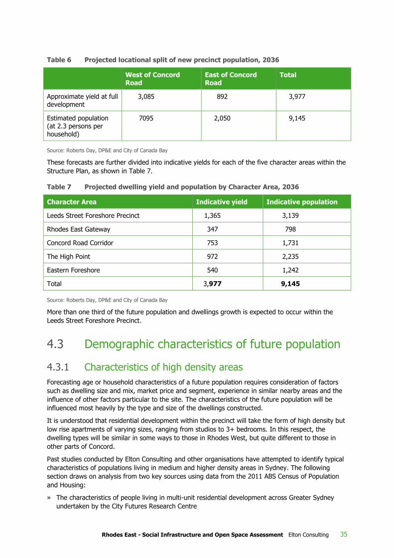
Rhodes East - Social Infrastructure and Open Space Assessment Elton Consulting 35
Table 6 Projected locational split of new precinct population, 2036
West of Concord Road
East of Concord Road
Total
Approximate yield at full development
3,085 892 3,977
Estimated population (at 2.3 persons per
household)
7095 2,050 9,145
Source: Roberts Day, DP&E and City of Canada Bay
These forecasts are further divided into indicative yields for each of the five character areas within the
Structure Plan, as shown in Table 7.
Table 7 Projected dwelling yield and population by Character Area, 2036
Character Area Indicative yield Indicative population
Leeds Street Foreshore Precinct 1,365 3,139
Rhodes East Gateway 347 798
Concord Road Corridor 753 1,731
The High Point 972 2,235
Eastern Foreshore 540 1,242
Total 3,977 9,145
Source: Roberts Day, DP&E and City of Canada Bay
More than one third of the future population and dwellings growth is expected to occur within the
Leeds Street Foreshore Precinct.
4.3 Demographic characteristics of future population
4.3.1 Characteristics of high density areas
Forecasting age or household characteristics of a future population requires consideration of factors
such as dwelling size and mix, market price and segment, experience in similar nearby areas and the
influence of other factors particular to the site. The characteristics of the future population will be
influenced most heavily by the type and size of the dwellings constructed.
It is understood that residential development within the precinct will take the form of high density but
low rise apartments of varying sizes, ranging from studios to 3+ bedrooms. In this respect, the
dwelling types will be similar in some ways to those in Rhodes West, but quite different to those in
other parts of Concord.
Past studies conducted by Elton Consulting and other organisations have attempted to identify typical
characteristics of populations living in medium and higher density areas in Sydney. The following
section draws on analysis from two key sources using data from the 2011 ABS Census of Population
and Housing:
» The characteristics of people living in multi-unit residential development across Greater Sydney
undertaken by the City Futures Research Centre

36 Rhodes East - Social Infrastructure and Open Space Assessment Elton Consulting
» The characteristics of apartment dwellers living in urban transformation areas or new higher
density developments adjacent to the harbour, (as opposed to apartments across the metropolitan
area as a whole), using the examples of Pyrmont, Zetland, Rhodes and Meadowbank.
These studies suggest that in comparison with lower density areas, high density dwellings across
Sydney are likely to be characterised by:
» A high proportion of young adults (25-34), along with an under-representation of both school aged
children and older adults 65+. Specifically, while proportions of pre-school children (0-4 years) are
broadly consistent with, or only slightly below, the metropolitan average, the proportions of school
aged children and adolescents aged 5-19 years are generally significantly below the average for
Greater Sydney. This suggests that people tend to stay in apartments while their children are
young, or until the second child is born, and then move to larger dwelling types
» A significantly higher proportion of households comprising couples without children and single
persons compared with lower density areas, and a correspondingly much smaller proportion of
households comprising families with children. The household profile appears to vary spatially
across Sydney though – with eastern suburbs, north shore and ocean or harbour locations having
a higher proportion of older people and lone person households and western suburbs such as
Liverpool, Fairfield, Canterbury and Auburn having higher concentrations of families with children
living in apartments
» Different tenure patterns, with a much higher proportion of dwellings in private rental and a lower
proportion that is owner occupied. In addition, there is a higher proportion of private dwellings that
are unoccupied. Urban Taskforce Australia found that occupancy is roughly equally split between
owner occupiers and renters. Renters are predominantly younger adults (under 45 years), while
the majority of owner occupiers are over 45 years
» A higher proportion of residents born overseas, with a particularly high proportion born on the
Asian continent
» High rates of labour force participation and high proportions of the workforce engaged in
professional or managerial roles
» Higher median weekly household income, reflecting high levels of workforce participation, high
levels of full-time employment and relatively high proportions with tertiary qualifications and in
professional / managerial positions.
These characteristics are generally consistent with the demographic profile of Rhodes in 2011.
4.3.2 Implications for the Rhodes East Precinct
Based upon the trends outlined above, the Rhodes East Precinct is likely to be characterised by:
» A high proportion of investor owned housing with around half being rental accommodation
» A high proportion of young adults (aged 25-40) who are well educated, working in professional
occupations and who are drawn to the area to be close to work
» A high proportion of households comprising one or two people
» A lower proportion of households comprising families with children. However, numbers of children
will still be significant due to the size of the incoming population, and social infrastructure will still
be required that addresses their needs
» Lower proportions of older residents aged 65+
» High levels of cultural diversity.

Rhodes East - Social Infrastructure and Open Space Assessment Elton Consulting 37
This means that social infrastructure will need to accommodate a wide diversity of needs, including
those of young single people and working adults, young children, older children, families, retirees and
older people. The likely heterogeneity of the population points to a need for flexible and multi-use
facilities capable of responding to changing needs, rather than focusing on the particular requirements
of specific age or life cycle cohorts.
The population of Rhodes East is likely to be similar to that of Rhodes West in its age and household
profile. This points to the importance of providing infrastructure and attractors that can help to
enhance social cohesion. Social infrastructure and community development initiatives can play an
important role in encouraging links and connections between new and existing communities reducing
the risk of polarisation and fragmentation.
It is not possible to forecast the precise age and household profile of the Precinct at this early stage of
planning. However, although the estimated percentages of total population for some of the key age
groups are relatively small (eg. school aged, and older adults), the actual numbers are likely to still be
relatively significant and will create demand for social infrastructure.
Given the projected demographics, a key challenge for the Rhodes East Precinct will be achieving a
socially diverse and sustainable community, in terms of a balance of age, household type and income.
The extent to which a reasonably diverse population may be achieved will depend largely upon the
mix of housing available, and in particular the proportion of larger dwellings capable of
accommodating families with children as well as affordable housing options. A development with a
high proportion of studio and one bedroom apartments may assist somewhat with affordability but will
also limit its appeal to families with children, and also possibly to older people. This may create the
potential for a community that lacks diversity.
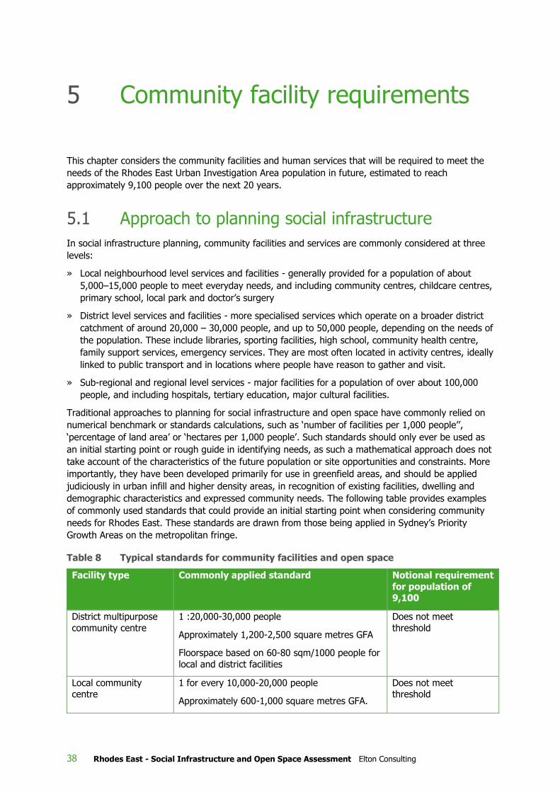
38 Rhodes East - Social Infrastructure and Open Space Assessment Elton Consulting
This chapter considers the community facilities and human services that will be required to meet the
needs of the Rhodes East Urban Investigation Area population in future, estimated to reach
approximately 9,100 people over the next 20 years.
5.1 Approach to planning social infrastructure
In social infrastructure planning, community facilities and services are commonly considered at three
levels:
» Local neighbourhood level services and facilities - generally provided for a population of about
5,000–15,000 people to meet everyday needs, and including community centres, childcare centres,
primary school, local park and doctor’s surgery
» District level services and facilities - more specialised services which operate on a broader district
catchment of around 20,000 – 30,000 people, and up to 50,000 people, depending on the needs of
the population. These include libraries, sporting facilities, high school, community health centre,
family support services, emergency services. They are most often located in activity centres, ideally
linked to public transport and in locations where people have reason to gather and visit.
» Sub-regional and regional level services - major facilities for a population of over about 100,000
people, and including hospitals, tertiary education, major cultural facilities.
Traditional approaches to planning for social infrastructure and open space have commonly relied on
numerical benchmark or standards calculations, such as ‘number of facilities per 1,000 people’’,
‘percentage of land area’ or ‘hectares per 1,000 people’. Such standards should only ever be used as
an initial starting point or rough guide in identifying needs, as such a mathematical approach does not
take account of the characteristics of the future population or site opportunities and constraints. More
importantly, they have been developed primarily for use in greenfield areas, and should be applied
judiciously in urban infill and higher density areas, in recognition of existing facilities, dwelling and
demographic characteristics and expressed community needs. The following table provides examples
of commonly used standards that could provide an initial starting point when considering community
needs for Rhodes East. These standards are drawn from those being applied in Sydney’s Priority
Growth Areas on the metropolitan fringe.
Table 8 Typical standards for community facilities and open space
Facility type Commonly applied standard Notional requirement
for population of 9,100
District multipurpose
community centre
1 :20,000-30,000 people
Approximately 1,200-2,500 square metres GFA
Floorspace based on 60-80 sqm/1000 people for
local and district facilities
Does not meet
threshold
Local community centre
1 for every 10,000-20,000 people
Approximately 600-1,000 square metres GFA.
Does not meet threshold
5 Community facility requirements

Rhodes East - Social Infrastructure and Open Space Assessment Elton Consulting 39
Facility type Commonly applied standard Notional requirement
for population of 9,100
Floorspace based on 60-80 sqm/1000 people for local and district facilities
Community hall or
meeting room
1 for 5,000 – 10,000 people
Floorspace based on 60-80 sqm/1000 people for local and district facilities
Community hall / small
community centre
District library 39 sqm per 1,000 people (plus 20% circulation
space) for populations of 20,000-35,000 people
Or
35 sqm per 1,000 people (plus 20% circulation space) for populations of 35,001-65,000 people
Based on State Library of NSW Guidelines
Does not meet
threshold
Cultural facility Will depend on size and scale of facility.
Generally 1:50,000+
Does not meet threshold
Community health
centre
1:50,000 people (Central Sydney Local Health
District Strategic Plan)
Does not meet
threshold
Childcare / early
education centre
1 place per 2 children aged 0-5 years 305 places
Out-of-school-hours care
1:4,000-6,000 people co-located with school or childcare centre
1 OOSH care centre
Primary school 1:2,000-2,500 dwellings 1 primary school
High school 1:6,000-7,500 dwellings Does not meet threshold
Open space 2.83ha:1,000 people
(City of Canada Bay currently 2.6ha/1,000 people)
Or 5% land area in higher density areas
1.8 Ha
Sporting fields 1 double playing field: 5,000 people (4-5 ha) 1 double playing field
Swimming pool /
Aquatic centre
1:40,000-50,000 people Does not meet
threshold
Recreation centre 1 indoor court: 25,000 people Does not meet threshold
Social infrastructure is provided by a wide variety of agencies, including all levels of government, non-
government organisations and the private sector. At this Structure Plan stage, the strategy for social
infrastructure provision needs to focus on the facilities which may have significant land requirements,
to ensure that sufficient land is identified in appropriate locations to meet future need. This focuses
particularly on facilities and services provided by local government and State Government agencies
(such as schools). Services provided by the Commonwealth Government (eg employment services,
some family services, veterans’ services,) have land requirements that are likely to be relatively

40 Rhodes East - Social Infrastructure and Open Space Assessment Elton Consulting
modest, and most likely will use available commercial office space within designated centres. Such
sites can be identified in subsequent detailed levels of planning.
Sites for facilities provided by the non-government and private sectors are usually acquired through
the private market and will need to be considered at a later stage of development as demand is
established. At the same time, it is recognised that some types of private / non-government facilities
may have significant land requirements. These include private schools, private hospitals and medical
services, churches, private childcare services, commercial gym and fitness facilities, residential aged
care facilities and entertainment facilities such as cinemas, hotels and restaurants. The Structure Plan
will need to allow sufficient scope and flexibility to accommodate such uses as demand emerges.
A forecast of around 9,100 additional people in Rhodes East will provide a catchment of sufficient size
to support a number of local level facilities and services within the precinct. In general, a population of
this size would not be considered large enough to warrant the provision of higher order district or
regional level facilities and would rely instead on those currently provided within the wider region such
as Rhodes town centre, Concord and Canada Bay LGA.
While social infrastructure planning for Rhodes East aims to understand the additional demand likely
to be generated by, or attributable to, a new population in this precinct, planning also needs to
recognise that recent and planned future population growth in nearby precincts over recent years
(Rhodes West, Wentworth Point in particular) has contributed to cumulative demands for district and
regional level social infrastructure and open space that may not be able to be met within these new
precincts – thus placing additional demands on existing facilities in surrounding areas. The future
development of Rhodes East is being planned within the context of this growing and changing
population and will add to these cumulative pressures, but would not be required to provide for unmet
or emerging demands from these adjacent precincts.
Facilities have been considered in terms of those which are provided by local government, those
provided by State Government agencies, and those provided by the private and non-government
sectors.
5.2 Local government community facilities
5.2.1 Community centres
Consideration of the needs of the future Rhodes East residents for community centre space has
incorporated information about the existing provision in Rhodes West and Concord.
The assessment of existing social infrastructure outlined in Chapter 3 indicated that there is already a
shortage of places where residents can meet for social, activity based, leisure or further education
purposes.
Some of these identified needs will be met through the new community centre at Rhodes West (The
Connection), located only a short distance from Rhodes East. The Connection will comprise a large,
modern community and cultural precinct with a range of activity spaces and a mix of community and
income generating uses. The Connection will be open every day, and its spaces are flexible and multi-
purpose, with a range of spaces and facilities in each of its four ‘spaces’ to cater for a diverse range of
uses.
As noted in 3.1.2, the Rhodes East Precinct already contains the Rhodes Community Centre. However,
due to this facility’s local heritage listing, limitations on refurbishment and already heavy usage, this
facility will not be able to meet the variety of social, leisure, learning and support needs generated by
a population of 9,100 people for local meeting and activity spaces.

Rhodes East - Social Infrastructure and Open Space Assessment Elton Consulting 41
A population of 9,100 additional residents would typically justify provision of a new local community
centre. In recognition that community spaces are already in high demand in the Rhodes area and
shortages exist for community meeting spaces, additional community space would provide venues for:
» Community activities, programs and classes, such as playgroups, fitness groups, art and craft
classes and after school activities
» Meetings of local organisations and community groups
» Accommodation for community services and the delivery of sessional and outreach services
» A base for community development activities and events
» Leisure and support activities for young people and for older people
» Adult education classes and training courses
» Hire for corporate or private functions, such as birthday parties.
A community centre can be a critical facility in areas of new development, providing activities and
services that promote social interaction and the development of community networks and which
support the health and well-being of residents. Community centres also provide a source of
community information and a base for community development initiatives that foster community
identity and sense of belonging.
New community centre space should therefore be provided within the Rhodes East Precinct to cater
for the needs of all ages, socio-economic groups and diverse cultural groups. Community centres
should ideally be multi-purpose facilities with a range of flexible spaces capable of meeting multiple
needs and delivering a range of activities and services to the incoming population. Canada Bay
Council’s Section 94 Development Contributions Plan (2015) adopts a rate of 162m2 per 1,000
residents for the provision of future community facilities in accordance with research by Cred 2011.
Application of this benchmark suggests the proposed additional 9,100 residents would generate a
need for an additional 1,474m2 of community facility floorspace. However, the benchmark includes a
broader range of facilities than just community centres, and also incorporates an allowance for district
and regional facilities within the wider LGA. Allowing for around 45m2 of this rate for these purposes
would imply a need to allocate around 1,065m2 floorspace (ie. 72% of the total 162m2 rate) to a new
community facility for the Rhodes East population.
By comparison, Elton Consulting typically recommends (as a starting point) a rate of provision of
about 60-80m2 for every 1,000 people for neighbourhood, local and district level facilities. This is
based on analysis of comparative rates of provision across a number of Sydney local government
areas and derived through the testing of provision rates on a number of successful projects. This rate
does not include specialist facilities (such as arts/cultural facilities) and is used as a guide only to
provide a broad estimate of community facility needs. A rate of 60m2 for local facilities would imply a
need for a considerably smaller facility, of around 546m2.
Consideration has been given to how this quantum of floorspace might be provided within the
Precinct, especially in light of Council’s preference for locating community facilities within an activity
hub. While there are many competing demands for future use of the Council-owned Rhodes
Community Centre on Blaxland Road, its location and current use as a community facility supports the
opportunity for a heritage-sensitive redevelopment into a larger ‘community hub’. On its own, an
additional 546m2 in community space is considered to be quite small, and would have limited potential
for flexible uses to complement capacity already in the area. However, application of Council’s higher
rate would imply a total of 1,065m2 additional space for incorporation into a redevelopment of this
site. Management of the facility and its activities in a way that complements and supports activities at
The Connection, is consistent with a community hubs model and makes best use of available
resources.

42 Rhodes East - Social Infrastructure and Open Space Assessment Elton Consulting
The Blaxland Road site adjacent to the Cavell Avenue and Denham Street ‘green corner’ mixed use
site would also provide opportunities for a flexible design of indoor-outdoor areas and assist in site
activation and place-making. A community hub at this site could also incorporate a space to meet the
identified shortfall in resident demand for large format events, which could be managed jointly with
The Connection’s Event Space.
Several alternative locations have also been considered for a potential new community facility. The
required space could be instead provided as part of the redeveloped Leeds Street Industrial Area. This
location also could create a focus for a community hub with indoor-outdoor space located within the
proposed waterfront plaza. The option of including the community facility within the proposed Rhodes
Leisure Centre has also been considered, but this site is within Rhodes West, it is very close to The
Connection and it would likely also require renegotiation of the VPA, which has only recently been
completed.
Guiding principles for the planning and provision of community facilities, developed by Elton
Consulting, are included in Appendix A. These principles are provided to assist identification of suitable
sites and future planning of community facilities in the Precinct. In summary, the location of the
community centre should be guided by the following criteria:
» Central to its catchment population and easily accessible by the majority of their users
» Visually prominent, with a main street location and presentation to the street
» Accessible by public transport, and located to maximize access for pedestrians and cyclists
» Fully accessible to enable use by people with limited mobility
» Located to enhance a sense of community, vibrancy and local civic identity, and to help create a
focal point or hub for the community. This includes places where people already have cause to
congregate, rather than on standalone sites, for reasons of safety, accessibility and convenience.
Shopping centres and schools are recognised as the key destinations where people tend to
congregate within a neighbourhood. Locations within or adjacent to commercial centres also add to
the activity level and critical mass needed to create a vibrant mix of activities and lively centre
» Located to provide a high level of safety and security, particularly at nights and weekends. This is
most usually associated with high levels of activity and casual surveillance, as well as lighting and
proximity to public transport
» Where possible, located adjacent to open space to allow for larger outdoor community events,
spill-over activities and children’s play. Locations adjacent to outdoor recreation facilities such as
tennis or netball courts can also provide a leisure focus as well as space for community activities
» Located to ensure access to safe and convenient parking, including shared parking with
surrounding land uses where appropriate.
A key trend in community facility provision involves a move towards multipurpose facilities that
function as ‘third places’ – informal public gathering spaces that enable people to sit, relax, meet,
gather and interact. They are places that encourage social connections and are essential to the
creation of a sense of community. Community centres are addressing the communal yearning for
‘places to spend time, where you don’t have to spend money’. They are busy, safe, and interesting
places where you can feel like you are part of a community, but not have to pay for the privilege.
Responding to the importance of the ‘third place’, the ‘community living room’ component to a
community centre is becoming increasingly prevalent. This model involves a focus on levels of
comfort, space and amenity that encourage people to linger and spend time in informal ways. Such
third places are also particularly important in higher density communities where space within the
home to entertain friends, study or just relax is limited. Community facilities can also play an
important role in higher density environments by providing space for hire for private functions and

Rhodes East - Social Infrastructure and Open Space Assessment Elton Consulting 43
meetings that may not easily be accommodated in smaller dwellings (such as for children’s parties,
birthdays as well as strata and body corporate meetings).
The actual layout and functions within a new community facility will depend on its overall size, to be
determined in conjunction with Canada Bay Council. However, it should complement the existing
spaces available within the Rhodes Community Centre (and those at The Connection), and should
incorporate:
» A variety of flexible spaces suitable for a range of social, leisure and cultural activities and
changing needs over time. Spaces could include:
> a hall suitable for large gatherings and events and physical activities
> some additional meeting and activity rooms of different sizes
> A room for children’s activities which opens onto an enclosed garden. This might be used for
child-minding for parents attending centre activities, for playgroups, and for before and after
school or vacation care
» Plenty of storage to meet the needs of a variety of user groups
» Kitchen suitable to support private functions such as birthday parties
» Adjacent outdoor space with children’s play equipment and barbecue, to provide for spill over
social events and activities for children and young people.
Depending on the design and opportunities to combine with spaces in the existing Community Centre,
there may also be an opportunity to provide for:
» Offices for a community development worker and for other human service providers
» Sessional or outreach health and welfare services such as baby health clinic, counselling or family
support services.
Given all these considerations, it is recommended that:
» The Rhodes Community Centre on Blaxland Road be expanded by 546-1,065m2 to provide a larger,
modern and complementary multi-purpose community facility for Rhodes East. Expansion at this
site presents some challenges with retention or incorporation of its heritage features, but would
reinforce the role of the centre as a community hub.
» Location adjacent to a small park or plaza as part of the ‘Corners Strategy’ could incorporate a new
large format space for public or private events and should allow for a playground / play area, café
or other local placemaking embellishments
» Operation of the expanded Rhodes Community Centre in tandem with The Connection will support
its role as a new community hub.
The Blaxland Road site is being considered for potential redevelopment - retaining the existing Rhodes
Community Centre building as part of a new, larger facility. Positioning the proposed ‘green corner’
area of new open space at the south western corner of the Denham Street and Cavell Avenue
intersection offers the opportunity to integrate this community use with adjoining open space. The site
is only a short distance from the station and Leeds Street foreshore, but is still sufficiently centrally
located to be accessible and visible.
Should the preferred site on Blaxland Road not be available for a community centre (due to competing
demands for its use), then alternative site options will need to be considered, consistent with the
locational principles above and in conjunction with Council. At this stage, options include:
» Leeds Street Foreshore Precinct

44 Rhodes East - Social Infrastructure and Open Space Assessment Elton Consulting
» As part of redevelopment and activation of the Rhodes East Gateway commercial development,
land-bridge and / or combined with a new primary school.
5.2.2 Facilities and services for older people
The proportion of older people expected to be attracted to Rhodes East Precinct is not likely to be
high, particularly in the early stages of development. However, there will still be older people wishing
to live near their families or remaining in the precinct, and it will be important that their needs are met
in order to ensure that they do not become isolated in a community otherwise oriented towards young
adults and young families.
The social, leisure and recreational needs of older people may be met through mainstream services
and facilities for the whole community, and through programs and activities for older people delivered
within the multi-purpose community centre. Leading practice now steers away from providing age-
specific buildings, such as senior citizens centres, which can only be used by specific sections of the
population and which thereby run the risk of being under-utilised for much of the week or as the
population changes. Instead, the usual practice now is to provide multi-purpose facilities which have
flexibility to incorporate activities for different target groups as required.
Older people will have access to the waterfront plaza at Leeds Street Foreshore Precinct, the
foreshore access and other pedestrian and cycle paths through the precinct, connecting to local parks
and amenities. These will support goals of active living, a connected community and an age friendly
environment.
5.2.3 Facilities for young people
As for older people, leading practice now steers away from providing separate facilities just for young
people, on the grounds of their under-utilisation for much of the time while young people are at
school or work.
At the local neighbourhood level, the needs of young people for space for social and leisure activities
may be met through activities available within the proposed expanded community centre, as well as
through a well-designed public domain, and the pedestrian paths, cycleways and areas of open space
along the waterfront. Some embellishments proposed for inclusion at McIlwaine Park and King George
V Reserve (eg. areas for informal sports, half courts) would also appeal directly to younger people. A
skate park proposed by Council’s Open Space Master Plan and Plan of Management (Corkery June
2015a and 2015b) for the eastern side of Concord Road between Cropley and Llewellyn Streets has
instead been incorporated into the Structure Plan as an extension of the ‘skateable moments’ / small
skatepark integrated into the foreshore edge in a new location under John Whitton (railway) Bridge
within the Leeds Street Foreshore Precinct. This proposed inclusion would support plans to create a
highly active hub in this area.
Young people will also be able to use the gym, courts and other facilities at the proposed Leisure
Centre near Rhodes Station (when built), although the swimming pool will offer lessons and programs
rather than recreational or lap swimming.
Provision of wifi hotspots and well-designed, well lit, modern spaces that are safe and comfortable
would support the social and recreational needs of younger people.
5.2.4 Libraries and cultural facilities
No new library facilities are included in the Rhodes East Structure Plan, as the projected population on
its own would not meet benchmarks where new facilities would be required. Instead the library needs
of new residents will be met by district level facilities at the nearby Concord or Five Dock libraries

Rhodes East - Social Infrastructure and Open Space Assessment Elton Consulting 45
(4kms and 8kms distant, respectively), or through the new digital collection Learning Space at The
Connection in Rhodes West.
Applying standards for library facilities as outlined in Table 8 (People Places- A Guide for Public Library
Buildings in NSW, State Library of NSW 2012) to the combined populations of Rhodes West and
Rhodes East (at approximately 23,500 people) would generate a need for around 928m2 of library
space. Much of this demand will be met through The Connection’s ‘Learning Space’, as part of
Council’s overall library network. This dedicated learning facility will include state of the art digital
equipment, a creative studio, digital classroom and flexible open community space, featuring hosted
programs and events. Its five areas comprise:
» Studio 1 – a classroom style room suitable for programs and learning
» Studio 2 – suitable for photography, video and music creation
» Digital Classroom – for private study in a shared environment
» Open Space – open air space for informal meetings
» Digital Gallery – high-tech gallery featuring changing artists.
The Digital Gallery will meet some of the needs identified in this study for creative and gallery space in
the local area.
The projected population would not be sufficient to support a cultural facility, which typically include
stages and theatres as part of a district or regional level facility in a major centre, serving a larger
population. Spaces for cultural and artistic expression could be incorporated into the proposed
expansion to the Rhodes Community Centre on Blaxland Road (eg rooms for classes and workshops,
exhibition space), consistent with Council’s Cultural Plan. However, it is recognised that there are
many competing demands for this site, and even for future uses within the proposed community hub.
The adjacent mixed use corner would, nevertheless, be an ideal location for display of public art.
Public art would also provide a focal point for the Leeds Street Foreshore, and embellishments to
parks and streetscapes throughout the Precinct. A foreshore location would be accessible to new
residents of Rhodes East as well as those in Rhodes West.
Some community and cultural events are currently held in Rhodes West and with further
embellishment through this Structure Plan there will be opportunities for additional events and
entertainment within McIlwaine Park and Brays Bay Reserve.
However, these facilities cannot cater for very large gatherings. For large entertainment and cultural
events, residents will need to access facilities at the Sydney Olympic Park precinct or elsewhere in the
wider Sydney or Parramatta areas.
5.3 State Government social infrastructure
5.3.1 Government schools
In areas of urban renewal, the Department of Education’s policy is to optimise use of its existing
assets, as its first preference, through solutions such as:
» Increasing the size, amenity and functionality of existing schools to manage growth
» Renewing existing assets to provide contemporary teaching spaces for students
» Realigning school catchment boundaries to appropriately manage growth where possible
» Managing enrolments to provide priority to ‘in catchment area’ students
» Using temporary classrooms to manage short term fluctuations in enrolment levels.

46 Rhodes East - Social Infrastructure and Open Space Assessment Elton Consulting
New schools will only be established where there are no other options available to use existing sites.
Planning for schools within this precinct has been handled through a negotiation process between
DP&E and NSW Department of Education. The Department of Education has advised that while high
school needs will be able to be accommodated at Concord High School in future, the projected
population growth from Rhodes East together with demand from Rhodes West will generate need for
a new primary school with 19-20 classrooms in the area. Discussions have therefore focussed on
opportunities for a ‘vertical school’ to meet the needs of primary school students likely to be
generated by rezoning and growth in this precinct. A school of this size would require approximately
5,700m2 gross floor space (excluding play areas) and a 2,000m2 floorplate over four levels, including
one floor of internal play and roof top play areas. Access to public open space is also required.
The Department applies the following guiding principles in planning for schools in high density areas:
Urban Design
» co-located with active open space
» minimum 2-3 street frontages
» no major overshadowing
» co-located with community services where possible (i.e. community centres, libraries)
» centrally located in residential catchment area.
Roads
» avoid locating on major and sub-arterial roads (RMS preference)
» located on collector road network
» located on existing bus (or public transport) routes to avoid duplication of bus traffic
» allowance for lay-by areas for pick up and drop off.
Environmental
» not located on contaminated land (otherwise remediated to a standard that is suitable for schools)
» not located adjacent to developments that area likely to result in significant health issues (i.e.
noise, vibration, air quality impacts)
» not located adjacent to heavy industrial development
» not located within the 1 in 100 year flood level
» emergency evacuation routes accessible for sites within proximity of flood prone land.
The guiding principles indicate there is the potential to co-locate a vertical school within a community
hub, such as the expanded multi-purpose community centre proposed for the Rhodes Community
Centre on Blaxland Road. It is recognised that this model could present practical design and
management issues that would need to be resolved with the Department of Education.
DP&E is continuing to work with the Department of Education in relation to the education
requirements of a future Rhodes East Precinct population.
5.3.2 Higher education
The higher education needs of Rhodes East residents would be met through existing TAFE and
university facilities.
The Northern Sydney Institute of TAFE’s Meadowbank and Ryde campuses are a short distance to the
north. Major changes to the TAFE funding model from 2015 will instead see greater competition for

Rhodes East - Social Infrastructure and Open Space Assessment Elton Consulting 47
course delivery, increasing specialisation amongst TAFE campuses, greater flexibility in where courses
are delivered (eg at workplaces) and changes to use of TAFE buildings and sites. The need to deliver
courses within workplaces and demand for outreach classes, may increase the need for rooms to be
available within community facilities. However, these classes would also require specialty equipment,
and are not likely to be suitable for multi-purpose shared use facilities, such as the proposed
community centre.
Students from this area would attend universities across Sydney, with Macquarie University, CBD
university campuses and Western Sydney University’s Parramatta CBD campus being closest.
Accommodation for other lifelong learning activities (eg community colleges, evening classes, U3A)
can be provided through other types of facilities such as community centres and schools, without the
need for purpose-built facilities. These needs should be considered in the design of the expanded
community facility proposed for Blaxland Road.
5.3.3 Public health services
The future population of the Rhodes East precinct will not be large enough to justify provision of any
community health or hospital facilities within the precinct, but will instead rely on those in the wider
region.
Public health services for residents of Rhodes East will continue to be provided by the Sydney Local
Health District (HD) through Concord Repatriation General Hospital, an Early Childhood Health Centre
at Concord and community health centres in the wider area.
Major projects are planned for Concord Repatriation General Hospital to 2018 (NSW Health Sydney
LHD), including development of a masterplan for the site to incorporate a new aged care precinct, a
new palliative care service, a Cancer Centre, an Ambulatory Care facility, imaging facilities and
upgrades to Emergency and operating theatres. In addition, there is provision for ongoing service
quality improvements.
Within Council’s Section 94 Contributions Plan, the Early Childhood Health Centre at Concord is
planned to be relocated into a new multi-purpose Concord Community Hub.
The capacity of health services is influenced as much by staffing as by the capacity of buildings, and it
is not a straightforward exercise to simply apply standards to derive future health service
requirements for a new population.
Development within Rhodes East has not been considered in the population forecasts which underpin
the Sydney Local Health District Strategic Plan 2014-2018. However, as part of the development of
the Structure Plan for Rhodes East, DP&E is continuing to consult with NSW Health. Population
forecasts for Rhodes East will need to be factored in to the Health District’s new Strategic Plan when it
is updated in 2018.
5.3.4 Emergency services
Fire and Rescue NSW
Rhodes East contains a volunteer (retained) Fire Station.
Fire & Rescue NSW (FRNSW) monitor and assess resource needs across Sydney as population and
demands change. It is expected that the precinct will be serviced from the existing Fire and Rescue
station on Concord Road, Rhodes East.
NSW Police
The Rhodes East Precinct falls within the Burwood Local Area Command, although the nearest police
station is located in Ryde.

48 Rhodes East - Social Infrastructure and Open Space Assessment Elton Consulting
Planning for police services relates more to emergency response times, and hence travel distance and
road networks, than it does to population thresholds. As the Precinct growth will occur within an
established area, there is unlikely to be any need for additional police stations.
Ambulance
As noted in Section 3, the Precinct is served by ambulances based in Denistone Road, Ryde.
As with planning for Police services, ambulance planning is made on the basis of rapid response times
rather than population thresholds. Development in this precinct is unlikely to create unsustainable
pressure on the response times from this station. No additional ambulance facilities are expected to be
required.
5.4 Private / non-government sector facilities
5.4.1 Neighbourhood shopping
Residents of Rhodes East Precinct will have access to a range of commercial and retail offerings with
the precinct.
The Structure Plan incorporates:
» Around 6,000-6,500m2 of convenience retail within the Rhodes East Gateway character area
comprising:
> 1,500-2,000m2 supermarket
> 600m2 specialty food grocery / liquor
> 1,000-1,500m2 restaurants or fast food
> 1,500m2 specialty and personal services
> 500-1,000m2 non-retail services.
» Around 7,000m2 destination retail within the Leeds Street Foreshore Precinct character area
comprising :
> Wine bars and cafes
> Small gourmet supermarket (max size of 1,600m2) and delicatessens
> Micro-brewery or other specialist retail uses.
As well as these retail and commercial services, these character areas would also be likely to include
places for informal meeting and gathering in their outdoor civic spaces.
The convenience retail centre proposed adjacent to Rhodes Station will integrate with existing retail
and commercial services at and near the western side of Rhodes Station.
Higher order shopping is available at the Rhodes Shopping Centre, also in Rhodes West.
5.4.2 Childcare facilities
A number of different forms of childcare and activities for young children are generally provided in a
community, including long daycare, family daycare, pre-school, occasional care and playgroups.
Additionally, services to support families with young children may be provided. It is not appropriate at
this stage of the planning process to try to anticipate need for the various specific types of services.
Instead, leading practice encourages planning of flexible multi-purpose childcare centres, which can
provide a mix of services or adapt as precise needs are identified.

Rhodes East - Social Infrastructure and Open Space Assessment Elton Consulting 49
The provision of childcare has changed substantially in recent years, associated with shifts in
government regulation and funding policy, such that the private sector is now the provider of the
majority of childcare centres in Australia. As such, the provision of childcare in most new
developments is now left largely to market forces. In common with the provision of childcare in most
new developments, childcare in Rhodes East will be provided by private sector providers, as demand
develops.
Benchmarks for the provision of childcare places tend to vary, from around 1 place: 5 children aged 0-
5 years in older suburban areas, to 1 place: 2 children in some higher density infill areas (eg City of
Sydney). Assuming similar rates of preschool aged children to those at the time of the 2011 census
and adopting the higher benchmark would suggest childcare demands in the order of 280 places for
residents of Rhodes East Precinct at full development.
The number of childcare centres required will depend upon the size of each centre in terms of number
of childcare places. There is no standard size of centre. However, for reasons of cost efficiencies,
there is a trend to provide larger centres (60-80+ places), where local demand justifies this. This
would suggest 4 new childcare centres will be required. These are expected to predominantly offer
Long Day Care services which suit most working parents.
It is not necessary that precise requirements for childcare are identified at this structure planning
stage. Childcare centres are a permitted use within residential areas and do not require land to be
designated at the master planning stage.
Planning for childcare will also need to address the need for out of hours school care for primary
school aged children. Out of School Hours (OOSH) care (also known as Out of School Hours Care –
OSHC) is now typically provided at most schools and some offer Vacation Care as well.
There are many successful examples where childcare centres have been co-located with community
facilities. Consideration should be given to the inclusion of a childcare centre, as well as out-of-school-
hours care, vacation care and, potentially, occasional care services, as part of the proposed
community facility and / or new school.
5.4.3 Private schools
Providers of independent schools undertake detailed demographic and feasibility assessments before
committing to new release areas. They also tend to acquire their sites through market processes,
rather than necessarily acquiring sites designated in master plans.
Demand for private schools reflects the socio-economic and religious profile of an area as well as the
availability of private schools in the surrounding area. The limited site area and size of development
sites in Rhodes East means there is unlikely to be demand for new private school sites within Rhodes
East.
5.4.4 Medical services
The needs of an additional 9,100 people will not be able to be absorbed by existing medical services
and a range of new medical and allied health services will be required.
Based upon the national benchmark of 1 GP per 1,100 people, the additional population will give rise
to a need for around 8 additional GPs. The additional GPs may be distributed through an expansion of
existing practices or establishment of new services. There is no standard number of GPs to make up a
general practice, but a minimum of about 4-5 GPs is now commonly regarded as needed to create a
viable practice. This suggests that 2 medical centres might be required.
Medical practices and other allied health services such as dentists and physiotherapists are provided
according to the commercial feasibility assessments of practitioners, and services may be located in

50 Rhodes East - Social Infrastructure and Open Space Assessment Elton Consulting
commercially leased premises, without the need for purpose built capital facilities. A range of other
services exist in the Concord Repatriation Hospital precinct.
5.4.5 Welfare and support services
The Rhodes East population is expected to be reasonably affluent and active and demand for welfare
and support services will be modest.
The expansion of existing services and development of new services will rely primarily on funding
increases to non-government services through government grant programs, in turn dependent upon
government budgetary processes. It will primarily require increases in recurrent funding for additional
staffing and program resources, rather than capital funding for new facilities. However, facilities with
land use requirements include residential care facilities for older people and accommodation services
for people with a disability, such as group homes. Sites for such facilities are usually acquired through
market processes as demand arises. At this early stage of the planning process, it is not possible to
identify particular requirements for such facilities.
A key need of welfare and support services in the area is for affordable office accommodation. Such
services are best located in centres where they are accessible by public transport. The proposed
community centre in Rhodes East could provide some office accommodation for sessional services.
However, given the large number of community health and support services that will be available at
the Concord Repatriation Hospital precinct, it is unlikely that additional space for such services would
be required in Rhodes East.
5.4.6 Places of worship
In addition to meeting spiritual needs, places of worship can also provide an important base for
community development, youth, volunteer and welfare support activities in new communities, and as
such can fulfil an important role in building community spirit and identity. Places of worship may also
provide halls and other spaces which can be utilised for community activities by the general
community. Others may contribute to demands for larger or flexible spaces within facilities such as the
proposed community hub.
Should demands exceed space available within the proposed community hub, the acquisition of sites
for places of worship is generally left to market forces, according to their ability to purchase sites, and
it is difficult to specifically identify sites at the master planning stage. However, the relatively high cost
of sites may preclude places of worship from establishing in urban infill communities.
5.5 Delivery of community facilities
The key facilities to be delivered for the Rhodes East Precinct are an expanded multi-purpose
community centre and a new primary school.
For the community centre, it should be noted that under current legislation, there is no source of
funds available with which to build community facilities. Under regulations set out in the Revised Local
Development Contributions Practice Note (DPI February 2014), councils wishing to exceed the
designated cap ($20,000 per dwelling in Canada Bay) may only use S94 contributions for “essential
works”. This includes land only for community facilities and land plus ‘base level embellishment’ for
open space and sporting facilities. The building of community centres is not considered to be
“essential works”. Accordingly, the funding of the construction of the community centres will rely upon
Council making the funds available, future reforms to the developer contribution system that allow for
contributions to be levied for building community facilities, or the introduction of other grant programs
for local government social infrastructure.
Rhodes East - Social Infrastructure and Open Space Assessment Elton Consulting 51
In relation to the need for a new primary school, it is important to note that new schools are generally
not developed until the Department of Education’s modelling indicates that there will be sufficient
demand to justify it. Any spare capacity within existing primary and high schools in the surrounding
area will be utilised first, and then opportunities exhausted to augment capacity on existing sites, for
example by use of demountable classrooms.
5.6 Summary
Rhodes East Precinct, at full development with a population of around 9,100 people, will be large
enough to support local neighbourhood facilities such as a primary school, neighbourhood and
specialty shopping, 4 childcare centres, 2 medical centres and new community centre facilities.
The precinct will not be large enough to warrant any district or regional level facilities, and will not
provide a suitable location for district or regional facilities serving the broader area by virtue of its
location on the peninsula, lack of a major centre and its proximity to Rhodes West. Rhodes East will
rely on existing district and regional facilities and services to meet the needs of its future population.
Growth forecasts for the area will need to be factored into the capital works and service development
plans of State Government agencies with regard to health, welfare, disability and aged care services
and facilities.

52 Rhodes East - Social Infrastructure and Open Space Assessment Elton Consulting
Access to open space for both active and passive leisure and recreation pursuits is regarded as critical
to physical and mental wellbeing and is seen as a key component of a healthy and sustainable
community. Open space is important for many reasons and is used by different population groups for
a wide range of leisure and recreation activities.
This chapter outlines the open space, sporting and recreation facilities that will be required to meet
the needs of the future Rhodes East Precinct population of around 9,100 people. It considers:
» The importance of open space
» Key sport and recreation participation trends that help to inform the approach to open space
infrastructure provision for the Rhode East Precinct
» Approaches to planning for how much open space to provide
» Planning principles to guide future provision.
6.1 Demand analysis
6.1.1 Trends in recreation and sport participation
NSW Data
Sport and physical recreation have long been important features of the Australian lifestyle and identity
and health and fitness has become a major lifestyle movement in recent years. However, a range of
data suggests there have been important changes in the ways in which people participate in physical
activity for both leisure and sport. Key trends in physical recreation participation and facility use
summarised in the Australian Sports Commission’s report The Future of Australian Sport (2013)
include:
» A movement from organised, team sports to a focus on individual fitness
» Substantial growth in indoor sport and recreation
» Flexibility in the times that people enjoy their recreation, as demands on time increase and work
practices change
» Greater demand for indoor facilities that are available all day, every day of the year.
The report notes that:
“People are fitting sport into their increasingly busy and time-fragmented lifestyles to achieve
personal health objectives. Participation rates in aerobics – running and walking as well as gym
memberships – have all risen sharply over the past decade while participation rates for many
organised and team sports, with the exception of soccer, have held constant or declined” (Standing
Committee on Recreation and Sport, 2010, quoted by Australian Sports Commission).
6 Open space and recreational requirements

Rhodes East - Social Infrastructure and Open Space Assessment Elton Consulting 53
“While participation rates in organised physical activities have remained level over the past decade,
participation rates for non-organised physical activities have grown ... Non-organised physical
activity has a much higher participation rate.”
These trends are also reflected in sports and physical activity participation data. The most recent
sports participation data is contained in the results of the Australian Bureau of Statistics 2013–14
Multipurpose Household Survey (ABS 2015). This report finds that, for people aged 15 years and over
in NSW, individual, non-organised physical activities are significantly more popular than organised,
team sporting activities. Increased participation in non-organised activities has been responsible for
the overall increases in regular physical activity between 2001 and 2010. The most participated in
activities are the more informal and unstructured activities (walking, fitness/gym, swimming, cycling).
These activities not only have higher participation rates in the most recent data, but the general trend
from 2005-2006 shows them all increasing in participation levels. Conversely some of the more
organised activities such as soccer and football sports, as well as tennis, experience much lower levels
of participation and are generally experiencing decreasing participation trends over time.
Parks Base (2014) also reports results of a comprehensive survey of park use across Australia
conducted between 2008 and 2014 and including 11,818 park user respondents. Survey results
confirm the dominance of non-organised activities within park space, with non-sport activities making
up the majority of park use. Playing or training for sport makes up 5% of hours spent in parks,
compared with dog activities, walking and enjoying the environment (each making up around 12-14%
of time spent in parks), use of children’s playground (8%) and relaxing (5%).
It is also important to understand the composition of the future population in planning for sport and
recreation infrastructure. As previously discussed, urban renewal areas such as Rhodes East are likely
to include a relatively low proportion of families with school aged children. (For example, in urban
transformation areas such as Rhodes West, Meadowbank, Pyrmont, Zetland and apartment precincts
of Newington, school aged children and adolescents (5-19 year olds) made up 7-12% of the
population in 2011, compared to 19% for Greater Sydney.)
This likely age profile of Rhodes East reinforces the importance of non-organised physical activity and
the need to ensure that adequate space is provided for informal, unstructured activities.
The need for informal, unstructured activity spaces is of even greater significance in higher density
areas where dwellings have no backyards and small living spaces. These informal spaces can provide
for activities ranging from children’s birthday parties, to family gatherings to quiet places to read and
relax.
The Rhodes context
The Open Space Masterplan for the Rhodes Peninsula (Corkery Consulting, June 2015a) presents
detailed information from an extensive review and engagement process in Rhodes. Key trends
identified through this work include:
» “The spectrum of public open space opportunities being provided is increasingly aligned with
community profiles and seeks to respond to community input, rather than be derived from the
application of an out-dated and inappropriate open space provision formula
» Public open space is not just limited to parks, but is increasingly recognised as incorporating
streetscapes, plazas, promenades and park areas; all comprising the shared public domain. In the
case of Rhodes Peninsula it extends from the ‘Front Door to the Foreshore’
» Public open space is recognised as making a major contribution to community health and well-
being
» Optimising physical connectivity for pedestrians and cyclists together with good public transport
that links the places people want to go to, is increasingly adopted as a central organising principle

54 Rhodes East - Social Infrastructure and Open Space Assessment Elton Consulting
» Planning and design of the public domain needs to respond to the growing awareness of the role
of placemaking, supported by public art and wayfinding strategies
» The expanded use of personal electronic devices with social media and other communication
technology is increasingly being used to raise awareness of public facilities, transport options and
events, and to facilitate social interaction
» Flexibility is recognised as essential to public open space planning and management to ensure they
can adapt over time to changing social needs and new opportunities” (p. 11).
In planning for Rhodes East, this data suggests that emphasis should be placed on the provision of
spaces and places for unorganised, unstructured recreation and leisure including both active forms
such as walking, running and gym activities. Also important are places for relaxation, contemplation,
pet exercise and general social interaction. Health and wellbeing in a broad sense, including both
physical and social/mental health, is an important theme that can help to guide the nature and type of
spaces to support the future population.
While the proportion of the population that participates in organised sport is quite small, there is
nevertheless a need to provide sporting facilities to accommodate a diversity of sporting codes. The
Open Space Plan of Management notes the shortage of sporting facilities in the Rhodes Peninsula, but
does not propose new facilities for this area. Council’s key strategies and plans summarised in Section
2.1, together with community feedback and advice received during preparation of this study, formally
recognise that the existing supply of active open space across the LGA is already at capacity. As for
other higher density urban renewal areas across Sydney, meeting the needs of the future population
of East Rhodes for access to sporting open space will be a key challenge.
6.1.2 Approaches to determining quantum of open space
As discussed above, traditional approaches to planning for open space in greenfield sites have
commonly relied on benchmark calculations. A commonly applied standard for calculating the
provision of open space in New South Wales is 2.83 hectares per 1,000 people. Within Canada Bay
LGA at present, the rate of provision is 2.6 hectares per 1,000 people. However, while such standards
can provide a useful starting point, a purely mathematical application is not desirable and unlikely to
provide outcomes which take into account the context of the site and balance community benefit with
efficiency and cost. Moreover, Council’s S94 Contributions Plan acknowledges that large new areas of
open space are not likely to be available in future (see Section 2.1 above).
Another mechanism utilised for determining the amount of open space is the percentage of land area
approach. The following table shows the range of percentages used in different urban renewal
projects.

Rhodes East - Social Infrastructure and Open Space Assessment Elton Consulting 55
Table 9 Percentage of land area as open space in selected high density areas
Place/project % of land area
Barangaroo Central 46
Harold Park 36
Green Square 14
Barangaroo South 10.5
Docklands, Melbourne 3.9
DP&E guidelines 5*
* The DP&E Guidelines are an acknowledgement, rather than a recommendation, that based on land analysis,
inner urban areas contain an average of approximately 5% of land area devoted to open space
In addition to the large variations in land devoted to open space across these urban renewal areas,
there does not seem to be a clear relationship between percentage of open space provided and size of
the population using it, effectiveness of open space or resident satisfaction. Open space with an
emphasis on quality of both design and materials can produce good community outcomes with
relatively low rates of provision, if appropriately and strategically planned.
Because of the limitations of numerical benchmark approaches in open space planning, their use is
progressively being superseded by policies, guidelines and performance criteria that focus on
accessibility, diversity and quality, rather than merely the quantum of open space to be provided.
6.1.3 Open space planning principles
Open space planning principles for Rhodes East are set out in Council’s Local Planning Strategy, the
Rhodes Peninsula Open Space Masterplan and Plan of Management (Corkery 2015a and 2015b) and
summarised in Section 2. In summary, the Rhodes Peninsula Masterplan adopts the following five
design principles:
» A Peninsula of Places
» Visual coherence in the public domain
» A connected and legible network
» Community engagement and partnerships
» Sustainable open space.
These objectives were confirmed in recent community engagement outcomes for the Precinct
undertaken as part of the structure planning process. Outcomes of the community workshops held in
April 2016 highlighted the following themes for the provision of open space within Rhodes East:
» New areas of open space should be considered in conjunction with access to the foreshore and
connections to existing open spaces. Existing open spaces can be improved and should be linked to
new areas of open space within the Precinct
» New open space should be of a high quality and offer a range of uses (including other community
uses) to different groups within the population to encourage activation and reasons to stay
» A variety of walking experiences and environments was supported.
An on-line community survey (darzin 2016) also found that parks and BBQ / picnic facilities were
considered to be the highest priority recreational and sporting facilities for the precinct.

56 Rhodes East - Social Infrastructure and Open Space Assessment Elton Consulting
6.2 Opportunities and constraints
The precinct presents a number of opportunities and constraints to be recognised in the planning of
open space. These are outlined below:
» The provision an adequate quantity of high quality open space for a range of uses should be a key
focus of the planning for this Precinct. Access to open space is of particular importance in higher
density environments in which residents have more limited access to private outdoor space.
» Existing sporting fields in the LGA are already over-subscribed, yet the existing urban pattern and
fragmented land ownership place constraints on the development of new fields within the precinct.
Council’s S94 Development Contributions Plan notes the significant constraints on purchasing
additional land and focuses instead on works to increase the capacity of existing facilities such as
embellishments, lighting, synthetic surfaces and other upgrades.
» The pattern of existing development places constraints on the availability of areas for new open
space in the precinct. Planning should consider open space provision both within and near the
Precinct and explore opportunities to enhance and embellish existing spaces within the Precinct
through provision of quality space that is well designed and utilises quality finishes and features.
» Key opportunities include the proximity of the Precinct to the harbour, an extensive network of
large and established parks and foreshore pedestrian and cycle paths which are popular and well-
used. Open space should maximise the Precinct’s waterfront location and views as an amenity and
utilise its qualities to create vistas, recreational opportunities as well as calming, contemplative
spaces.
» Planning for a new ferry terminal within the northern part of the Precinct presents an opportunity
to attract residents to integrate active travel and public transport for commuting as well as a
destination and focus for place-making and community and commercial activities. However, this
opportunity also presents challenges, such as incorporating a future ‘river pool’ near this area.
» Participation data suggests that open space planning should recognise the importance of areas of
passive open space as well as the need for a network of connections and paths to support a range
of unstructured recreational and leisure activities such as walking, jogging and cycling.
» Streets can make important contributions to the quality and availability of publically accessible
open space if they are designed as more than just roads but as multifunctional public spaces.
‘Complete Streets’ are places not only for movement but for socialising, entertaining, commerce
and civic activity. Most streets will continue to provide connections for vehicles but will also be
designed to cater specifically for cyclists and pedestrians. The street will include the carriageway,
footpath, landscaping including trees and seating, small urban spaces, building forecourts and
street-based retail that will contribute to significantly enhance urban life in the Precinct.
» Active open spaces elsewhere in the LGA will continue to be used for sporting activities. In
addition, the new Leisure Centre to be developed adjacent to Rhodes Station will provide a range
of facilities for active sporting needs of a wide range of age and population groups within an
accessible location for future residents of Rhode East.
» Opportunities to potentially use building rooftops as areas of open space have not been explored
as part of this study for several reasons, including expected building sizes / footprints and types
and the expectation that solar panels will be incorporated as a sustainability initiative.
» Planning for this precinct should also focus on the creation of a healthy built environment – a key
direction identified in A Plan for Growing Sydney (NSW Government, 2014).
» Good quality urban design and architecture are also essential in creating welcoming, activated and
safe streets and neighbourhoods for an active population.

Rhodes East - Social Infrastructure and Open Space Assessment Elton Consulting 57
6.3 Structure Plan
The Rhodes East Structure Plan (November 2016) proposes the following open space inclusions.
Table 10 Open space planned for Rhodes East
Approximate size (m2)
Foreshore access including resting areas 10,800 (900m long x 12m wide)
Leeds Street Foreshore plaza 4,500 (100m x 45m)
Corner Strategy open space / widened verge:
- Cavell Avenue and Denham Street
- Cavell Avenue and Averill Street
- Cropley Street and Concord Road -
100
100
100
New pedestrian links including a land bridge 3,000
Floating river pool 600 (25m lap pool – 8 lanes x 2.5m
and 10m x 5m kids pool)
Total 19,200
Source: Roberts Day, DP&E and City of Canada Bay Structure Plan
The Structure Plan provides for creation of a significant public area at the Precinct’s northern
waterfront and an opportunity to provide foreshore access between Ryde Bridge and McIlwaine Park.
The Structure Plan also provides for several other, smaller areas of open space that link in with, or
extend, existing areas of open space (a Green Necklace concept).
Key features of open space included in the Structure Plan include:
» Redevelopment of Leeds Street (currently light industrial area) foreshore to provide “an urban
interface that engages with the water, supports the destination retail and creates a transit plaza to
the future Ferry Wharf” (Roberts Day, DP&E and City of Canada Bay, 2016, p. 14)
» A continuous foreshore access linking parks, resting areas, destinations and people
» Potential nodes in an integrated open space, heritage and public art trail
» Enhancement of McIlwaine Park by breaking down the barrier of Concord Road through
construction of a land bridge.
» Open space is supplemented by provision of secondary and internal green links via enhanced
streets and new streets and pedestrian connections
» A ‘Corner Strategy’ will further supplement open space by providing intimate open spaces or
widened verges on identified mixed use corner sites
» Potential for a ‘river pool’ in Brays Bay.
6.4 The quantum of open space
The Structure Plan has made provision for a total of 1.9 ha to be zoned as open space. Approximately
half of this is made up of the foreshore walk, which in the Rhodes East context is potentially an
important space for active recreation such as walking, jogging and cycling.

58 Rhodes East - Social Infrastructure and Open Space Assessment Elton Consulting
On the face of it, this level of provision would appear to be low for a population of this size. In
particular, the rate of provision is considerably less than the greenfields standard of 2.83 ha/1,000
people cited in Section 6.1.2 above and the current rate of provision across the LGA of 2.6ha per
1,000 residents. Application of these rates would imply a demand for around 25 ha.
However, Canada Bay Council and community members who have participated in discussions around
the future of Rhodes East Precinct recognise that there are limitations on opportunities to provide
large new areas of open space, especially given the Precinct’s location close to significant and well-
used waterfront parks and paths. The focus of planning has been on ensuring residents have access
to open space which is of high quality, easily accessible and provides for a diversity of recreation
experiences, rather than on the quantum of open space.
In addition to local parks and the foreshore walk, recreation needs will be met by creating good
quality streetscapes, recognising that walking, running and cycling are likely to be the priority
recreation activities of future residents. The Structure Plan has a focus on open space provision within
a framework of ‘Complete Streets’, where streetscapes are reconfigured to prioritise pedestrians and
cyclists over cars and to create new links around the foreshore and to the railway station. This
approach emphasises the creation and enhancement of small-scale, place-based open spaces such as
walkways, outdoor dining, foreshore plazas, landscaping, seating, shade, bicycle parking, car sharing
and dog-friendly environments.
The waterfront location also presents opportunities to meet some of the future recreation needs
through water-based activities, rather than all needs being met through traditional parks and playing
fields. Opportunities to create a ‘river pool’ to address demand for swimming and water play are
discussed in the following section and will be further explored in subsequent stages of the planning
process.
The limited opportunities to provide new open space within the precinct mean that residents of
Rhodes East will also contribute to the use of open space, particularly active sporting facilities, within
nearby areas. This will require enhancements to the available facilities to support their more intensive
utilisation. The detailed ways in which existing spaces can be enhanced through further
embellishments, and associated contribution arrangements, will need to be negotiated with Council.
Given the potential for the range of open space facilities and embellishments outlined above, the
Precinct’s proximity to nearby parks and waterways, and other district and regional recreational areas
and the financial contributions to be made, the quantum of recreational open space proposed within
the Structure Plan is considered to be adequate.
6.5 Requirements for active open space
Provision for active open space within Rhodes East will be through further connections and linkages
for pedestrians and cyclists described in Section 6.3, which provides the opportunity to deliver 1.08ha
of foreshore access, joining into the existing walkway from Rhodes West to John Whitton Bridge in the
Precinct’s north. Council and the community have expressed a strong view that the popularity of
walking and cycling should be reinforced and new opportunities provided through this Structure Plan.
Council recognises that new opportunities for areas of active open space within the precinct are
limited. In particular, opportunities to acquire new land within the precinct for sports fields are limited,
due to its fragmented pattern of ownership and land costs. In addition, Council has expressed the
view that existing areas of open space both within and adjacent to the precinct should not be
cluttered with new sporting fields or facilities and instead should be retained as open space.
Council’s current approach, as reflected in its Recreation Strategy and the Section 94 Development
Contributions Plan, is to use a range of strategies to upgrade (or investigate upgrades at) existing

Rhodes East - Social Infrastructure and Open Space Assessment Elton Consulting 59
sporting facilities and areas of open space elsewhere in the LGA (including within Concord and on the
Yaralla Estate), to enable their more intensive utilisation.
As such, additional needs for active recreation within Rhodes East will be met through a combination
of the following:
» Minor embellishments to existing parks, including King George V Reserve, Uhr’s Reserve and
McIlwaine Park will support informal activities such as running, cycling, kicking balls, throwing
frisbees and informal team sports. There will also be space for children’s play equipment near
paths and seating
» An emphasis on attracting regular use of streetscapes, linkages and walkways within and beyond
the precinct for a wide range of daily activities including social activities, exercise and commuting
» Upgrades to existing sporting fields in the wider area through embellishments (including new
synthetic surfaces, lighting, some additional land acquisition) consistent with Council’s S94
Development Contributions Plan for sporting fields. Residents of Rhodes East will contribute
financially to these upgrades through contributions through Council’s S94 Plan or negotiated
Voluntary Planning Agreements (VPAs)
» Subject to future plans by Sea Scouts and the Commonwealth, there is potential for future
investment in foreshore works and new facilities at Uhrs Point Reserve to support boat launching
for the Dragon Boats, as well as facilitating access for the Sea Scouts
» Use of the planned Rhodes Leisure Centre facilities, just beyond the Precinct boundary at Rhodes
Station, for activities such as gym, court sports, table tennis
» Use of The Connection in Rhodes West to access indoor activities such as yoga and dance classes
» Use of indoor and outdoor sporting facilities, courts and pools elsewhere in the LGA, including
Majors Bay Reserve, the Five Dock Leisure Centre, Cabarita and Drummoyne Swim Centres and the
Concord Sports Precinct
» Accessing regional level facilities within the Sydney Olympic Park precinct, which will be more
readily accessible with construction of the Bennelong Bridge connecting Homebush and Rhodes
West.
River pool opportunity
As outlined in the previous section, the location of the Precinct also presents opportunities to meet
some of the demand for active recreation facilities through a unique public ‘river pool’ in the
Parramatta River.
Demand for a new aquatic facility
Current aquatic facilities within the City of Canada Bay include the Cabarita Swimming Centre in
Concord and the Drummoyne Swimming Centre. These are located 7kms and 10kms respectively from
Rhodes East.
Participation rates in sport and recreation can provide information on likely demand for a range of
activities, including swimming. The Australian Bureau of Statistics (ABS) Multipurpose Household
Survey published in 2015 shows swimming is the third most popular physical recreation activity in
New South Wales, with 9% of the population engaging in this activity as a regular sport or recreation.
The Recreation Facilities Report (@Leisure 2013) noted that demand for outdoor aquatic facilities is
likely to be one of the greatest recreation needs within the LGA by 2031, even in the absence of plans
for additional population in Rhodes East:
“It is unlikely that the existing outdoor pools will cater for the total number of people who will
want to swim (12,000 estimated.) –especially older persons, and young children by 2031, and

60 Rhodes East - Social Infrastructure and Open Space Assessment Elton Consulting
hence if swimming participation is to increase additional indoor opportunities, especially for
training and lessons and programs will be required” (@Leisure 2013, p. 54).
Contemporary planning standards in urban areas suggest that aquatic facilities should be provided at
a rate of approximately one for every approximately 100,000 people. The City of Canada Bay’s
Recreation Facilities Report suggests a rate of 1:60,000 people for local outdoor swimming pool and
1:75,000-100,000 people for district facilities. In addition, the report suggests that pools should be
provided within a 2.5-3km distance of households.
While Council’s Section 94 Development Contributions Plan provides for a new indoor aquatic facility
and upgrades to Drummoyne Swimming Centre, there are no plans for new outdoor pools.
Initiatives to improve water quality for swimming
The Parramatta River Catchment Group (PRCG) is a regional organisation of local councils (including
the City of Canada Bay), state agencies and community representatives whose aim is to work together
to improve the health of the Parramatta River catchment (http://www.parramattariver.org.au/). The
group meets several times each year “to discuss issues and opportunities relevant to improving the
natural environment within the Parramatta River catchment and to undertake regional, collaborative
projects that assist in addressing one or more issues affecting the local environment”.
The PRCG is promoting an Our Living River initiative (http://www.ourlivingriver.com.au/our-mission/)
to make the Parramatta River Swimmable Again by 2025. The initiative argues that every Australian
should have access to a natural place to swim and relax. It argues that ‘Sydney Deserves a World
Class River’ for a range of reasons, including:
» Greater liveability – supporting and enhancing life through greater biodiversity, better air quality
and access to activities such as swimming, picnicking, cycling and relaxing
» Social connection – creating an attraction and place for social and recreational activities, fostering
connections and being a fun, safe place to meet
» Biodiversity – for healthy vegetation and fish and where people can be near nature
» Better Public Amenities – for residents and tourists to enjoy the Parramatta river
» Healthy Living – where people are attracted to swim, walk, cycle, hold events or bring children to
play
» Business opportunities – attracting restaurants and venues to invest in waterfront locations
» Increased Property Value – highly desirable locations will attract buyers, investors and promote
development.
Scientific modelling shows it is possible to improve river water quality to an acceptable level for these
uses and the project appears to have wide community and agency support.
The Our Living River website shows 22 potential future locations for swim sites within the Parramatta
River. Four suggested sites are located within 500 metres of the Rhodes East northern foreshore:
» Meadowbank
» Shepherds Point
» Putney Park
» Prince Regent Swimming Club Baths.
Each of these sites is located on the northern side of the Parramatta River and none are currently
swimmable due to poor water quality.
Plans to improve water quality within the Parramatta River to a swimmable standard are also
consistent with a growing ‘Urban Plunge’ (or ‘wild swimming’) movement internationally to reclaim

Rhodes East - Social Infrastructure and Open Space Assessment Elton Consulting 61
urban waterways and successful projects in Copenhagen, Berlin, London and New York. A number of
projects and proposals for urban swimming are being devised and considered by architects, engineers,
artists and planners as a way of better engaging with rivers as critical elements of our cities,
incorporating them into the urban experience in new and imaginative ways and maximising new
leisure opportunities (see for example H Partridge September 5, 2014, “From lidos to plunge pools:
urban swim projects around the world”, Financial Times http://www.ft.com/cms/s/2/876a63e8-32a4-
11e4-a5a2-00144feabdc0.html#axzz3CX0GBzem; O Wainwright August 13, 2014, “Wild swimming in
the city: come on in, the river's cleaner!”, The Guardian
https://www.theguardian.com/artanddesign/2014/aug/13/wild-swimming-urban-waterways-floating-
lidos; J Withers, September 13, 2014, “Urban Plunge - open swimming in the heart of the city”, The
Ecologist”
http://www.theecologist.org/green_green_living/2543077/urban_plunge_open_swimming_in_the_hea
rt_of_the_city.html – accessed 24 June 2016).
Rhodes East context
With a proposed new population of around 9,100 residents, ABS participation rates would suggest
there will be demand from around 850 new users within the Rhodes East population. While the
projected population on its own does not approach the level of demand to support even a local pool,
the precinct is distant from other pools in the LGA and the wider catchment could contribute towards
demand for its use.
The proposed Leisure Centre near Rhodes station will go some way to meeting swimming needs for
the existing population and is close to suggested river pool locations. However, it will be privately
operated and will not provide opportunities for recreational swimming and relaxation in a public
setting.
While the proposal raises a range of important technical and operational issues (water quality,
feasibility, governance), a river pool would contribute towards a shortfall in active open space in the
precinct by meeting other active recreational needs for aquatic facilities. It could also contribute to
social integration and community connections in Rhodes by creating a destination and focal point for
relaxation, social and recreational activities and safe places for people of all ages, including young
people, to meet and have fun.
In combination with other attractors at the waterfront precinct such as destination retail and harbour
views, a river pool has the potential to act as a popular local destination and unique local experience.
6.6 Requirements for passive open space
6.6.1 Parks, plazas and linkages
The planning of open space should ensure equitable access to recreation opportunities. A commonly
recognised standard for passive open space involves ensuring all residents are within 400-500 metres
walk from a park.
Due to the small size of the Rhodes East Precinct, the majority of new dwellings will be easily within
400 metres of new or existing areas of open space and new plazas and connections. The proposed
distribution therefore meets this objective and provides reasonably equitable access.
A centrepiece of Council’s open space strategy includes provision for an upgrade and inclusion of new
elements (public art, interpretive signage and memorial, pathway) in Churchill Tucker Reserve
adjacent to Rhodes Station. The proposed Pacific Campaign Walk will link Churchill Tucker Reserve
with the adjacent McIlwaine Park and the Kokoda Track Memorial Walkway.

62 Rhodes East - Social Infrastructure and Open Space Assessment Elton Consulting
Proposed new areas of open space range in size from 100m2 for the Corner Plazas, to 1.08ha for the
foreshore access and resting areas. In addition, the Complete Streets approach will focus on streets
as areas of open space with pedestrians and cyclist prioritised over cars. All areas will include a wide
range of inclusions and embellishments, such as:
» Walkways and plazas
» Landscaping and tree plantings
» Seating, shade and covered areas
» Bicycle parking
» Dog-friendly facilities (drinking bowls, bags and bins)
» Barbeque and picnic facilities
» Lighting
» Spaces for markets, gatherings and performances
» Drinking fountains, toilets and amenities
» Access to water and electricity
» Signage and spaces for public art.
Passive open spaces throughout the precinct should be unique, each providing a variety of different
offerings. They should together form a comprehensive network of open spaces that collectively meet
a diverse range of community interests and needs.
6.6.2 Playgrounds
There are opportunities for the area’s open spaces to include a range of playground experiences for
young children. Playgrounds encourage children to engage in non-organised physical activity and
provide important community meeting places that encourage social interaction and assist social
cohesion. These playgrounds should collectively provide a range of play environments for children of
various ages and a range of play experiences, including challenging play opportunities for older
children.
6.6.3 Activities for young people
Other amenities that cater to older children and young people should also be included in open space
in the Rhodes East Precinct. An allocation for a skateboard facility in Rhodes East in Council’s S94 Plan
has been incorporated into the Structure Plan as a ‘skateable moments’ / small skatepark integrated
within the Leeds Street Foreshore Precinct ; under John Whitton Bridge. Other possible facilities such
as for rollerblading, bike/BMX, scooter riding, half courts for informal ball games or climbing walls
should also be considered. Such facilities and spaces are important for young people who are not
interested in structured sporting activities.
Precise facilities for young people to include within the parks will require further discussion between
Council and the incoming population of Rhodes East.
6.7 Regional facilities
Regional and wider district level open space, sport and recreation facility needs of the new Precinct
community will be met through the existing regional level facilities provided in the wider LGA and
Sydney Olympic Park. These facilities can be readily accessed by rail, bicycle and on foot. It is

Rhodes East - Social Infrastructure and Open Space Assessment Elton Consulting 63
however, acknowledged that many of these facilities are already under pressure from high demand
generated by existing residents, or from other residential development proposed for the area, such as
at Sydney Olympic Park. This is a matter for further consideration by the City of Canada Bay Council.
6.8 Conclusion
In terms of local open space and recreation facilities, this study has identified:
» Limited opportunities for large new areas of open space within the Precinct
» Provision of 1.92 ha of land to be zoned as public open space, as identified in the Structure Plan
» Passive local open space distributed to ensure equitable access for future residents and of a quality
and level of embellishment to support a range of passive and informal active recreational activities
» Linear open space in new linkages and design of ‘Complete Streets’
» Potential for a river pool.
Needs for access to sporting open space will be met by enhancements to existing playing fields in the
surrounding area to enable their more intensive utilisation. Arrangements for contributions to support
these further embellishments for off-site facility upgrades will need to be negotiated with Council.
The future community of Rhodes East will also rely on indoor sports courts and spaces within the
proposed Rhodes Leisure Centre and The Connection in Rhodes West, as well as on existing open
space and recreation facilities elsewhere in the LGA, in Sydney Olympic Park and across the sub-
region.
64 Rhodes East - Social Infrastructure and Open Space Assessment Elton Consulting
This report has considered the community facilities, human services and open space that will be
required to support population growth arising from future development within the Rhodes East Priority
Precinct Investigation Area. The precinct is one of a number within the Sydney metropolitan area
designated for housing densification in areas around transport hubs.
Relevant policies and objectives of the NSW Government and the City of Canada Bay Council have
been reviewed to provide the guiding framework for the planning and provision of community facilities
and open space.
The study has considered the social context of the precinct and characteristics of the existing Rhodes
East population, which numbered 733 people living in 274 private dwellings at the 2011 Census.
Residents of these households are on average older than the LGA median and the area currently
contains a relatively high proportion of family households. In most other ways, the Rhodes East
population shows strong similarities with the LGA population as a whole. Population characteristics of
higher density communities, such as nearby Rhodes West, have also been examined, to provide useful
insights into the characteristics of people likely to move into the Rhodes East Precinct in future.
Existing human services, community and recreational facilities and open space in and around the
Rhodes East Precinct and their capacity to absorb demand likely to be generated by future residents
have been assessed. Rapid growth and development in Rhodes West has seen new facilities being
provided by Council, developers and the private sector to fill known shortfalls. Social infrastructure in
Rhodes East is more limited, reflecting its low density character. The existing Rhodes Community
Centre on Blaxland Road is heavily used, but is an older, dated facility. A new cultural and community
precinct, known as The Connection, will shortly open in Rhodes West. Rhodes West also contains a
large commercial and retail centre and several childcare centres. A wide range of other services and
facilities are available in nearby centres such as Concord, Burwood, Strathfield, Bicentennial Park and
Sydney Olympic Park, which are easily accessible by rail, bicycle and on foot. Concord’s facilities
include schools, a library, community centre, hospital, medical facilities and commercial areas. A
library, school and regional open spaces are, or will soon be, located to the west in Wentworth Point
and the Sydney Olympic Park precincts. Key needs for the existing community include access to
flexible meeting and activity spaces for a range of purposes, indoor and outdoor places and spaces for
large community or private gatherings, local medical services such as doctors and allied health
services, and improved public transport. Some of these needs will be met at The Connection
community hub. However, additional services will be required by the area’s growing population in
future.
Rhodes East Precinct contains several areas of good quality open space and harbourside public areas,
including plazas near the station (Churchill Tucker Reserve) and northern waterfront (John Whitton
Bridge Park) and the large McIlwaine Park. Upgrades and embellishments of parks and open spaces
across the peninsula have recently been completed. Open space and recreation needs include
additional access to sports fields, good quality walkways and plazas where residents can walk, meet,
access the waterfront, shops, food and activities, open lawn areas and parks, barbeque and picnic
facilities with good amenities, public toilets and signage. On the basis of this assessment, new local
services, facilities and quality open space will be required to cater for the future population.
The Structure Plan for Rhodes East shows that the precinct could accommodate around 4,000 new
dwellings and an additional population of around 9,100 new residents in a human scale high density
development style across five distinct ‘character areas’. One third of the future development potential
for the Precinct is located within the Leeds Street Foreshore Precinct, between the railway line and
7 Conclusion

Rhodes East - Social Infrastructure and Open Space Assessment Elton Consulting 65
Concord Road. Evidence from other high density urban infill areas, including Rhodes West, suggests
that the population will comprise a high proportion of young adults (aged 25-40) who are well
educated, working in professional occupations. Most households will comprise only one or two people,
with relatively low proportions of families with school aged children and older people aged 65+. The
area is also expected to contain a high proportion of rental properties and high levels of cultural
diversity.
On the basis of these population projections, assessment of existing facilities and discussions with
government agencies, the facilities recommended for inclusion in Rhodes East and included in the
Structure Plan are shown in Table 11.
Table 11 Recommended community facilities and open space for Rhodes East
Identified need Proposed strategy Estimated cost
Time-frame
Responsibility
Community facilities
Flexible, appropriately
sized meeting and activity spaces
Spaces for further
learning
Indoor / outdoor places for large
community or private
gatherings and events
Heritage-sensitive
expansion of Rhodes Community Centre,
Blaxland Road by 546-
1,065m2 to create a larger multi-purpose community
facility or community hub
Situate adjacent to small park or plaza / active
green corner of mixed use and open space at the
south western corner of
Denham Street and Cavell Avenue
Operate the expanded
Rhodes Community Centre in tandem with
The Connection to support its role as a new
community hub
$2.9 million -
$5.6 million, based on cost
estimate of
$5,300 / sqm
Short
term Council
Schools 4 storey primary school of
5,700m2 total gfa located
near accessible public open space
Dependent
upon school
design. Cost of typical primary
school is around $15
million
As
demand
arises
Department of
Education
Local medical services 1-2 new medical centres Market
demand Private sector
Convenience retail and
specialty commercial
venues where people can meet, eat, drink
and relax
Private sector Market
demand Private sector
Childcare Potential for 4 new Market Council / Private
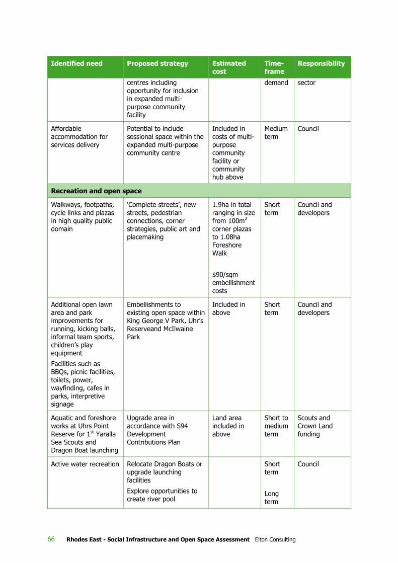
66 Rhodes East - Social Infrastructure and Open Space Assessment Elton Consulting
Identified need Proposed strategy Estimated
cost
Time-
frame Responsibility
centres including
opportunity for inclusion in expanded multi-
purpose community facility
demand sector
Affordable
accommodation for
services delivery
Potential to include
sessional space within the
expanded multi-purpose community centre
Included in
costs of multi-
purpose community
facility or
community hub above
Medium
term Council
Recreation and open space
Walkways, footpaths,
cycle links and plazas in high quality public
domain
‘Complete streets’, new
streets, pedestrian connections, corner
strategies, public art and placemaking
1.9ha in total
ranging in size from 100m2
corner plazas to 1.08ha
Foreshore
Walk
$90/sqm
embellishment
costs
Short
term
Council and
developers
Additional open lawn
area and park improvements for
running, kicking balls, informal team sports,
children’s play
equipment
Facilities such as
BBQs, picnic facilities,
toilets, power, wayfinding, cafes in
parks, interpretive signage
Embellishments to
existing open space within King George V Park, Uhr’s
Reserveand McIlwaine Park
Included in
above
Short
term
Council and
developers
Aquatic and foreshore
works at Uhrs Point
Reserve for 1st Yaralla
Sea Scouts and Dragon Boat launching
Upgrade area in
accordance with S94
Development
Contributions Plan
Land area
included in
above
Short to
medium
term
Scouts and
Crown Land
funding
Active water recreation Relocate Dragon Boats or
upgrade launching
facilities
Explore opportunities to create river pool
Short
term
Long
term
Council

Rhodes East - Social Infrastructure and Open Space Assessment Elton Consulting 67
Identified need Proposed strategy Estimated
cost
Time-
frame Responsibility
Access to sporting
fields
Developer contributions
towards sporting field upgrades and
embellishments
Short
term
Council and
developers
Indoor recreation and
activity space
Use The Connection,
Leisure Centre and other
facilities in the wider LGA
Short to
medium
term
Council and
private sector
Key community facilities recommended for inclusion in Rhodes East Precinct are:
» An expanded multi-purpose community centre (with an additional 546-1,065m2 floorspace) to be
provided as part of a heritage-sensitive redevelopment of the Rhodes Community Centre on
Blaxland Road, adjoining an active ‘green corner’ of mixed use and open space at the south
western corner of Denham Street and Cavell Avenue. This expanded facility would complement
and expand the range of community uses and spaces, and would operate in synergy with The
Connection in Rhodes West
» Convenience retail and specialty commercial venues where people can meet, eat, drink and relax
» 4 privately operated childcare centres (depending on size)
» Local medical centres
» Primary school.
In relation to the proposed expansion of the Rhodes Community Centre on Blaxland Road, it is
recognised that there are many competing uses for the site, including a new primary school. But given
its current role, potential for expansion, its central location within the community, proximity to public
transport and opportunities to integrate development with an active Green Corner within the Structure
Plan, an expanded community centre would be an ideal use of the site. A dedicated funding source
will be key to provision of such an expanded facility, and while no such source currently exists, there
are proposals to reform funding for the planning and development of community facilities in the
longer term and opportunities for one-off grants from State or Commonwealth Government to fund
local government social infrastructure which could be pursued.
The need for a new local primary school has been identified, but its final location, timing and delivery
arrangements remain subject to ongoing discussions between DP&E and the Department of
Education.
In terms of local open space and recreation facilities, this study recognises that there are important
challenges to providing additional areas of open space in this area, including fragmented land
ownership within the precinct, large areas of good quality open space within close proximity and high
costs of acquiring new open space. The Structure Plan instead adopts a model for open space
provision that focuses on creating new walkways and connections, linking local areas with the harbour
and parks, embellishing existing areas of open space and creating a high quality public domain. This
approach is supported by Council’s Open Space Masterplan and other policies and has been
successfully applied in other high density residential areas. In summary, the Structure Plan provides
for:
» 1.9 ha of new public open space, made up of a continuous foreshore access, redevelopment of
Leeds Street foreshore to provide a foreshore transit plaza (future Ferry Wharf) and destination
retail and commercial activities, enhancements to McIlwaine Park (including potentially breaking

68 Rhodes East - Social Infrastructure and Open Space Assessment Elton Consulting
down the barrier of Concord Road through construction of a station bridge) and investment in
foreshore works and new facilities at Uhrs Point Reserve
» Secondary and internal green links and a high quality public domain via enhanced ‘Complete
Streets’, new streets, pedestrian connections, ‘Corners Strategy’, public art and placemaking
» Exploration of opportunities for development of a ‘river pool’
» Passive local open space embellished to a standard consistent with the range of passive
recreational activities needs of a high density population and the recommendations of Council’s
Open Space Masterplan.
Needs for access to sporting open space will be met by enhancements to existing playing fields in the
surrounding area to enable their more intensive utilisation. Arrangements for contributions to support
these further embellishments for off-site facility upgrades will need to be negotiated with Council.
The Structure Plan also includes potential sites for a future river pool to contribute towards active
open space, subject to further investigations of feasibility.
The future community will also rely to some extent on existing open space and recreation facilities in
Rhodes West, Sydney Olympic Park, Concord, Burwood, Strathfield and the wider area for access to
regional open space, sporting fields, indoor sports courts, outdoor court complexes and aquatic
facilities. However, with population growth in surrounding areas, these facilities are reaching their
capacity the facilities proposed within this Structure Plan are needed to provide high quality public
spaces, places and connections to support this new population of Rhodes East.

Rhodes East - Social Infrastructure and Open Space Assessment Elton Consulting 69
@Leisure Planners, 2013. Recreation Facilities Strategy. Prepared on behalf of the City of Canada Bay
Australian Bureau of Statistics. 2011 Census of Population and Housing
Australian Bureau of Statistics, 2015. 2013–14 Multipurpose Household Survey
Australian Sports Commission, 2013. The Future of Australian Sport: Megatrends shaping the sports
sector over community decades, CSIRO
City of Canada Bay, 2010. Local Planning Strategy 2010-2031
City of Canada Bay 2015. S94 Development Contributions Plan
City of Canada Bay Rhodes Peninsula Community Profile and Place Plan (2011)
City of Canada Bay November 2012. Rhodes Peninsula Place Plan Summary Document
City of Canada Bay 2014. Community Safety & Crime Prevention Plan 2014 - 2018
City of Canada Bay 2014. Cultural Plan, prepared by Stephanie Kelly
City of Canada Bay, November 2014. Urban Activation Precinct Submission for Rhodes Central - –
Submission to DPE
City of Canada Bay 2012. Riverside - A Scoping Study Developing Public Art, Design and Cultrual
Programs for the Foreshores of the Parramatta River.
City of Canada Bay 2008. Let’s Play: Providing outdoor playgrounds for families in the City of Canada
Bay
City of Canada Bay 2015. Rhodes West Development Control Plan
City of Canada Bay 2009. Draft Rhodes West Masterplan
Corkery Consulting, June 2015a. Rhodes Peninsula Frontdoor2Foreshore Open Space Master Plan,
prepared for the City of Canada Bay
Corkery Consulting, June 2015b. Rhodes Peninsula Open Space Plan of Management, prepared for the
City of Canada Bay
Cred Community Planning, December 2011. Community Facilities Resourcing Strategy, prepared for
the City of Canada Bay
Future Cities Program 2014. Future City Report
Milne & Stonehouse and Guppy Associates, City of Canada Bay Arts Plan 2012 – 2020 Summary
Document, prepared for City of Canada Bay, adopted 2012
NSW Health, Sydney Local Health District, undated. Concord Repatriation General Hospital Strategic
Plan 2014 - 2018
NSW Department of Planning & Environment, November 2015. East Rhodes Precinct Demographic
Profile
NSW Government, 2014. A Plan for Growing Sydney
Our Living River initiative, http://www.ourlivingriver.com.au/our-mission/ - accessed 24 June 2016
8 References

70 Rhodes East - Social Infrastructure and Open Space Assessment Elton Consulting
Parks Base, 2014. State of the Sector: Report on sports fields, Exploring how authorities plan and
manage urban sports fields, www.parksbase.com
Parramatta River Catchment Group (PRCG) website, http://www.parramattariver.org.au/ - accessed
24 June 2016
Partridge, H. September 5, 2014, “From lidos to plunge pools: urban swim projects around the world”,
Financial Times http://www.ft.com/cms/s/2/876a63e8-32a4-11e4-a5a2-
00144feabdc0.html#axzz3CX0GBzem – accessed 24 June 2016
State Library of NSW, 2012. People Places: A guide for Public Library Buildings in New South Wales –
third edition
Wainwright, O. August 13, 2014, “Wild swimming in the city: come on in, the river's cleaner!”, The
Guardian https://www.theguardian.com/artanddesign/2014/aug/13/wild-swimming-urban-waterways-
floating-lidos – accessed 24 June 2016
Withers, J. September 13, 2014, “Urban Plunge - open swimming in the heart of the city”, The
Ecologist”
http://www.theecologist.org/green_green_living/2543077/urban_plunge_open_swimming_in_the_hea
rt_of_the_city.html – accessed 24 June 2016)

Rhodes East - Social Infrastructure and Open Space Assessment Elton Consulting 71
Appendices
A Vision and principles for Rhodes Central
B Open space and recreational facility rates of provision
C Guiding principles for community facility provision

72 Rhodes East - Social Infrastructure and Open Space Assessment Elton Consulting
A-1 Our Vision
Rhodes Central will be an exciting and vibrant place to live and work through the creation of a
connected and diverse community.
The Vision for Rhodes Central is based on the following principles:
A-1-1 A healthy place
The Rhodes Central precinct will:
» Be walkable.
» Increase active and natural social interaction through increased foot traffic and reduction in car
use.
» Be landscaped to provide opportunities for rest and recreation.
A-1-2 Sustainable
The Rhodes Central precinct will lead the way as one of the most sustainable precincts in Sydney and
likely Australia.
The Rhodes Central precinct will seek innovative solutions to implement:
» A strong mix of residential, commercial and retail opportunities to ensure the precinct is self-
sufficient and provides daily conveniences to reduce unnecessary out of precinct car travel.
» The provision of less than 1 car space per dwelling.
» Smarter mix of vehicle use and support services, including integrated car share and electric
recharge facilities.
» Sustainable building design and orientation to reduce ongoing energy consumption.
» Energy rated buildings (eg. Green Star system).
» Efficient building standards tied to planning incentives to leverage mini CHP (combined heat and
power) and solar solutions.
» Innovative precinct wide management of waste.
» Integrate best practice stormwater design and the efficient use of water resources.
2 Source: City of Canada Bay, November 2014.
A Vision and principles for Rhodes Central2

Rhodes East - Social Infrastructure and Open Space Assessment Elton Consulting 73
A-1-3 Designed to inspire and implement a walkable pedestrian
precinct
Rhodes Central is a transport oriented development, located directly adjacent to Rhodes Rail Station.
The precinct will be developed with emphasis on internal access and connections to and from major
transport and infrastructure. The precinct will:
» Promote pedestrian and cycle activity.
» Provide safe, convenient & attractive footpaths for pedestrians.
» Provide excellent bike share ways and connections, including supporting systems (i.e. bike sheds,
bike hire and storage facilities).
» Provide direct route connections to major facilities and frequently utilised resources.
» Provide a vibrant, safe and inviting amenity.
» Reduce car use and provide less on street parking to encourage higher use of streets for
pedestrians and bikes.
» Create walkable, well connected, safe, weather protected (where appropriate) and attractive
pedestrian routes.
A-1-4 Creates a vibrant community
A vibrant community will be developed through a multi layered approach of reducing car use to
minimise streets dominated by cars and encouraging an active precinct through the increased public
space and pedestrian movement on the streets.
» Provide a mix of housing types and commercial opportunities that encourages residents of all ages
and abilities to work and live within the precinct.
» Provide a continuous public waterfront access.
» Create a foreshore activity hub, mixing opportunities for retail, cafes and restaurants.
» Create opportunities for recreation and urban public spaces.
» Provide opportunities to create self-contained communities to maintain an active street culture
through everyday use of local shops and services.
» Opportunity to create an artist’s hub, to provide studio space and associated residential
accommodation. This would provide complementary opportunities for outdoor art exhibitions. eg.
‘Sculptures by the River’.
» Investigate options for an additional public commuter ferry and/or public wharf to enhance
functionality and activate a riverside culture and meeting place.
A-1-5 Integrates social diversity and economic sustainability
» Deliver 5% affordable housing and housing for aged persons.
» Integrate community, recreation and cultural facilities.
» Create and maintain affordability through appropriate dwelling types, mix, density and location.
» Create an appropriate balance of residential and commercial development, to ensure all general
daily needs can be met within the precinct.
» Accommodate specialist support services such as facilities for continuing education.

74 Rhodes East - Social Infrastructure and Open Space Assessment Elton Consulting
» Create alternate ways to structure the retail precinct, including exploring options for distinctive
retailing.
A-1-6 Creates jobs of the future
A focus of the precinct plan will be to ensure sufficient jobs are retained and created to support the
new population. It is intended that where a population of 6,000 people can be housed, approximately
2,800 jobs will be required to support the network. The Rhodes Central project will seek to:
» Retain some existing industries.
» Pedestrian oriented design to ensure all daily services are conveniently located within walking
distance. Detailed planning will occur to ensure that each precinct within the Rhodes Central has a
distinctive character and urban form.
» Creation of an artist’s hub. Provision of studio space with residences above enhancing a diverse
employment sector.
» Education facilities close to Rhodes train station to enhance opportunities and convenience for
people to engage in continuing education (such as Open University in the UK)
» Encourage opportunities for distinctive retailing.
A-1-7 Focus on connections and relationships to major
infrastructure
» The precinct will be a Transit Oriented Development (TOD) being located adjacent to, and within
800m of the Rhodes Rail Station.
» The plan for the precinct will enhance connections to the Rhodes rail station.
» Maximise patronage and connections to local bus services.
» Investigate the opportunity for a ferry wharf within the precinct to provide direct water access to
the City.
» Utilise facilities proposed for Rhodes West including the Recreation Centre and Multipurpose
Community Centre whilst providing additional attractors and facilities within the precinct that
provide diversity and opportunities to residents in Rhodes West.
» The foot/cycle access across the new pedestrian bridge to Olympic Park will be able to access
these facilities and provide added viability through higher use.
A-1-8 Provides appropriate building height, scale and form
Activation of Rhodes Central will be led by diverse building forms and architecture. Vibrancy on the
streets through retail opportunities and high pedestrian traffic will be coupled with diverse building
facades to create interest and clear building identification within the precinct.
» Establishes urban scaled streets and public spaces.
» Provides a range of residential densities and heights, with particular emphasis on achieving high
density in low rise buildings.
» ‘Form based’ controls will be used to ensure that there is a focus on building form.
» Achieves appropriate orientation and solar access.
» Provides a mix of housing types to encourage a diverse population.

Rhodes East - Social Infrastructure and Open Space Assessment Elton Consulting 75
» Encourages a relationship between residences and street interface. Wherever possible, ground
floor apartments should have front doors that are directly accessible from the street.
» Ensure a minimum of 6 architects are involved in designing the built form within the precinct,
avoiding a mono- design culture. This could include opportunity for architectural design changes
every 100m.
» Achieve high quality built form and urban design.
» Improve sight lines, north/south to the river and open space.

76 Rhodes East - Social Infrastructure and Open Space Assessment Elton Consulting
NB excludes golf course
3 City of Canada Bay LPS, 2010a
B Open space and recreational facility rates of provision3

Rhodes East - Social Infrastructure and Open Space Assessment Elton Consulting 77
Specific facilities as identified in the City of Canada Bay Open Space and Recreation Needs Analysis (June 2008) include the following:
» 150 parks (13 ‘regional’, 13 ‘district level sports grounds or multi-purpose parks’, and 124 ‘local’
parks and ancillary spaces)
» 17 sportsground complexes (with 68 summer and winter season sports fields as summarised in
Table 6.4 , below)
» 3 golf courses (one private and two public)
» 17 barbecue/picnic areas
» 11 unrestricted dog ‘off-leash’ areas
» 1 bicycle training track and several walk/cycle routes
» 48 playgrounds and one skateboard facility
» 24 tennis courts (at five centres) and 34 netball courts (at one centre)
» 2 swimming/aquatic centres
» 1 indoor leisure centre (Five Dock Leisure Centre).

78 Rhodes East - Social Infrastructure and Open Space Assessment Elton Consulting
A co-ordinated
network of facilities
Community facilities should not be planned in isolation but be considered
as a broader network of facilities that work together to meet a broad range
of community needs, across a district or sub-region. Planning and
delivering facilities as a network represents an integrated, strategic
approach to community facility provision. It allows facilities to provide a
different range of offerings, with the option for each facility to include
unique, specialist services or amenities.
The key to a successful network of facilities is the organisation of facilities
within a hierarchy. A facility hierarchy includes larger and specialist, higher
order facilities (e.g. central libraries, performing arts facilities, exhibition or
conference facilities and galleries) serving a wider sub-regional or LGA-wide
populations down to small, local facilities to meet the day to day needs of
their immediate, surrounding communities.
By considering facilities as part of a network, duplication of services,
programs, spaces and amenities can be avoided, therefore, representing a
more economically sustainable approach to community facility planning.
Central to
catchment and
equitable access
Community facilities should be central and accessible to the population
they are intending to serve. Leading practice favours the location of
community buildings in urban centres to enhance accessibility and
connectivity with related uses. Well used community facilities tend to be
located in places that are readily accessible by public transport and where
people already congregate, such as shopping centres and schools. These
locations increase convenience and decrease car trips by reducing the need
for multiple trips when dropping children off at school and/or childcare,
linking with transport for journeys to work, accessing services and
undertaking everyday tasks such as shopping. These locations also
enhance visibility, safety and convenient access. Adequate parking nearby
also promotes good access to facilities.
The facility building should comply with the principles of universal design
by facilitating access to and use of the facility and its spaces by all
individuals and groups (regardless of age, ability, cultural background or
level of social or economic advantage/disadvantage). This relates to
providing a high level of physical access, connection and way-finding as
well as ensuring services, programs and activities are broadly advertised
and promoted and are affordable.
C Guiding principles for community facility provision

Rhodes East - Social Infrastructure and Open Space Assessment Elton Consulting 79
Location to promote
visibility and
accessibility
To be well used and serve identified social needs, community facilities
should be highly visible. Ideally, they should be on a main street with
ground floor street frontage for optimum visibility and accessibility.
Enabling an awareness of what happens inside also promotes usage.
Community facilities are an important part of the civic fabric of our centres
and suburbs. Accessibility and visibility through main street locations with a
ground floor presence can be important to maximising utilisation and
enhancing accessibility. Recent examples like Vinegar Hill Library and
Community Centre at Rouse Hill Town Centre in Western Sydney
demonstrate how community facility space can be well integrated with
town square type development without compromising the availability of
valuable retail space.
Clustered/co-
located
Co-locating or clustering community facilities, including libraries,
community centres and community service centres, is presented as a key
principle for the provision of community facilities.
The community hub model, which involves co-locating facilities on
neighbouring sites or in a single building, is also proposed as a key
approach for consideration. Community hubs provide a range of offerings
and can, therefore, become key focal gathering points within a community;
attracting a range of users and promoting social connection and cohesion.
The community hub model can extend beyond co-locating community
facilities, to clustering community facilities with other activity generating
uses such as transport nodes, shops, schools, childcare, parks and
playgrounds.
Clustering can also contribute to overall sustainability by reducing the need
for multiple trips and allowing residents to carry out a number of tasks in a
single location through a single trip. Case study research demonstrates the
preference of users of community facilities to combine trips with shopping
and other activities.
Flexibility and
multiple use
Community facilities should be designed and built to maximise flexibility in
use, so they can respond and adapt as needs change. Where possible,
buildings should be capable of delivering a range of programs and services,
rather than designated for single uses or specific target groups that may
quickly become out-dated. Flexibility is enhanced by providing multi-
purpose spaces capable of accommodating a diversity of uses, thereby
enabling a range of activities and target groups to use the facility and in
doing so, ensure maximum use and optimisation of space. Multi-use
facilities are also more dynamic and capable of responding and adapting to
the changing needs and preferences of the community. Facilities that are
responsive and flexible will be used more intensively over their lifetime.
Serving identified
social needs
Community facilities should address the social needs of the particular
community in which it is located in order to contribute to residents’ and
workers’ health, wellbeing and quality of life. Programs, activities and
services offered should respond to the needs and interests of the people
that live and work around it and foster long term social benefits for the
community. The planning and design of a community centre should reflect
the potential programs, activities and services envisaged.

80 Rhodes East - Social Infrastructure and Open Space Assessment Elton Consulting
Inclusive and
welcoming
Facilities should be welcoming and accessible to people of all ages, cultural
backgrounds, abilities, income levels and interests. This can be achieved
not only through the provision of spaces catering to different groups and a
design that provides universal access, but also through effective
programming – ensuring activities and services are provided for a broad
range of people. In doing so, facilities can also play a role in helping to
bring together different groups in the community.
Contribute to public
domain and sense of
place
Community facilities should contribute to urban vitality, local identity and
sense of place, and become important focal points and gathering places for
the community. A strong connection between the facility and the broader
community can be fostered through development of facilities on landmark
sites and with distinctive architecture and quality design. Community
facilities should be distinctive civic buildings and welcoming places, and
should present as a reflection of local culture. This helps ensure they
develop a strong local profile and are well known in the community,
thereby promoting high levels of usage. Incorporating public art into the
building design is also important in creating distinctive and welcoming
community centres. Public art is an important avenue to tell local stories
and to create places that are recognised and valued in the community.
Near open space for
activities and events
Locations adjacent to open space including town squares, village centres
and parks increase the range of activities that can occur on community
facilities land. As an example, community centres adjacent to parks and
playgrounds are ideal locations for playgroups. Facilities located next to
civic squares provide opportunities for markets, festivals and similar events.
Locating community facilities near open space areas is another approach to
enhancing utilisation, flexibility of use and providing opportunities for a
wider range of community building activities. It is also another way to
ensure that community facilities are integrated into their surrounding
physical environment and seen as ‘part of the community’.
Connected to public
transport,
pedestrian and
cycling networks
Planning for community facilities requires a focus on enhancing efficiency
and utilisation. Public transport enhances accessibility for all population
groups. As a principle, community facilities should ideally be located within
400 metres walking distance of a regular public transport stop. Linking to
pedestrian and cycling networks provides another avenue to promote the
accessibility of facilities to all groups in the population and is a further
means to encourage sustainable behaviour and a healthy and active
lifestyle.
Of sufficient size
and design to
enable expansion
and adaptation
It is difficult to precisely predict the absolute requirements for community
facilities for a future population. Assumptions about demand are based on
current projections regarding future populations. These projections may
change and therefore affect requirements for community facilities land.
Past experience has shown that it is important to provide some flexibility in
the provision of community facility space.

Rhodes East - Social Infrastructure and Open Space Assessment Elton Consulting 81
Financial and
environmental
sustainability
Community facilities should be financially sustainable and provide value for
money for their users, owners and operators. While capital costs are a
major issue, ongoing operational costs are also important. Key
considerations include building design that reduces ongoing operating and
maintenance costs as well as design that considers cost recovery including
the incorporation of space for lease for either community or compatible
commercial uses
Delivering environmentally sustainable buildings is a mandate for many
local governments. Community facility buildings offer opportunities for
Council’s to lead by example, demonstrate new sustainable materials and
technologies and become leading practice projects with an educational
role.
Environmentally sustainable facility buildings typically have lower operating
costs and are, therefore, are also a more financially sustainable option.
Safety and security
Community facilities should be designed in accordance with Crime
Prevention through Environmental Design (CPTED) principles. They should
provide a high degree of personal safety for people entering and leaving
the building, especially at night. Locating facilities in activated areas such
as urban centres ensures higher levels of passive surveillance and
increased security.
Avoidance of
conflict with
neighbouring uses
Master planning processes can provide an opportunity to locate community
facilities uses in areas where impacts on residential and other uses can be
minimised. In greenfield areas siting facilities to incorporate some form of
separation and/or buffering from residential areas is often an important
consideration in reducing any potential future conflict. Design and building
orientation are also important considerations.