Embed Size (px)
Citation preview
1
Proceedings
Regional Geoheritage Conference 2016
The 9Th Indonesia-Malaysia Conference
“Exotic Past for our Future”
Seminar Held on 24 November 2016
In Hotel Hyatt Regency Yogyakata, Indonesia
Field Trip Held on 25 November 2016
Proceedings
Regional Geoheritage Conference 2016
The 9Th Indonesia-Malaysia Conference
Scientific editors
Sari Bahagiarti K
Ibrahim Komoo
Yunus Kusumahbrata
Suharsono
Mohd. Syafeea Leman
Che Aziz Ali
Hanang Samodra
C. Danisworo
Bambang Prastistho
Suvapak Imsamut
Technical Editors Muhammad Yusuf Muslim
Gneis Desika Zoenir
Chairman
Bambang Prastistho
FACULTY OF MINERAL TECHNOLOGY
UNIVERSITAS PEMBANGUNAN NASIONAL “VETERAN’ YOGYAKARTA
2016
COMMITTEE OF REGIONAL GEOHERITAGE CONFERENCE 2016
Steering & Scientific Committee
Prof. Ir. Dr. Sari Bahagiarti K. – Rector of Universitas Pembangunan Nasional
“Veteran” Yogyakarta
Prof. Emeritus Ibrahim Komoo – Vice Precident of Global Geopark Network
Enviromental and Natural Resouces Cluster in
Malaysia
Dr. Yunus Kusumahbrata – Expert Staff of Ministry Energy and Mineral
Resources
Dr. Suharsono – Deen of Faculty of Technology Mineral
Prof. Dr. Mohd. Syafeea Leman
Prof. Dr. Che Aziz Ali
Ir. Hanang Samodra, M.Sc.
Prof. Dr. Ir. C. Danisworo, M.Sc.
Prof. Dr. Ir.Bambang Prastistho, M.Sc.
Dr. Suvapak Imsamut
Organizing Committee
Prof. Dr. Ir. Bambang Prastistho, M.Sc.
Dr. Ir. Jatmika Setiawan, M.T.
Ir. Peter Eka Rosadi, M.T.
Dr. Ir. Basuki Rahmad, M.T.
Dr. Ir. C. Prasetyadi, M.Sc.
Ir. Siti Umiyatun Choiriah, M.T.
Herry Riswandi, S.T, M.T.
Dewi Fitri Anggraini
Niko Anugrah Wyanti
Muhammad Yusuf Muslim
Faiz Akbar
Faiz Zain Adli
Nova Deka Valentina
Dimas Ihsan
Arif MuhamadEditor
Gneis Desika Zoenir
Sandi Putrazony
Budiamala Prawoto
R. Aburizal Valdi
Akmal Musyadat
Preface
Bismilahirrahmanirrahim, Assalamu’alaikum wa rahmatulahi wa barokatuh.
Dear distinguished participants and committee.
In this nice opportunity, I appreciate to all of you for your considerable effort
that made the Regional Geoheritage Conference 2016 or the 9th Joint Conference
Indonesia – Malaysia Geoheritage Conference happened.
I really thankful to your participations for joining and attending the Conference
in Yogyakarta. Special Region of Yogyakarta is well known as education and cultural
city. Yogyakarta also become a considerable touristic region especially in cultural
heritage. Right now geoheritage in Yogyakarta become more attractive.
In this occasion, the conference is very simple. Conference will be held over two
days. First day we will held conference and geotrack in the second day.
There is two main speakers for RGC 2016. The first speaker is Mr. Ibrahim
Komoo as Vice President Global Geoparks Network (GGN) and Mr. Yunus
Kusumahbrata as Expert Staf Ministry of Energy and Mineral Resources of Indonesia
Republic. For the next season, we also have speakers from Thailand and two speakers
from Gunungsewu UGG and Batur UGG Indonesia. Moreover, we have 30 outstanding
papers that will be presented in this conference. The papers are consist in 12 oral papers
and 23 posters presentation with the same value.
In geotrack we will discover several geoheritage sites in Gunungsewu UGG,
such as Miocene pillow lava of Berbah; ancient volcanic product of Nglanggeran;
exciting bioturbation within shallow marine Sambipitu Formation; and Karst Museum of
Indonesia at Wonogiri.
I wish this conference will give us inspirations and enhance the cooperation in
Southeast Asia countries, especially in the field of geoheritage. Happy sharing for the
progress of our region.
Finally, I would like to express my gratitude to Geological Agency – Ministry
of Mineral Resources, especially Center of Geological Survey performa a booth
concerning the wonderful of geoheritage and geopark of Indonesia.
Wassalamu’alaikum wa rahmatulahi wa barokatuh.
Prof. Dr. Ir.Bambang Prastistho, M.Sc.
Chairman
Regional Geoheritage Conference 2016
Table of Content
Committee
Preface
Table of Content
(O1) Geoheritage of Bau: An Important Geo-Area in the Roposed Sarawak Delta
Geopark 1
(O2) Strike Slip Deformation of the Post Cretaceous Period at the Genting-Klang
Quartz Ridge, Selangor, Peninsular Malaysia 2
(O3) Magnificence Geological Phenomenon Along sg. Batu Pahat: Inspiring the
Jerai Geopark Initiative 14
(O4) Paleoclimatic Change Analysis Based on Stratigraphic Data, Jayapura and its
Surrounding Area, Jayapura District, Papua Province 16
(O5) Quantitative Assessment of Cave Stability Analysis at Gua Damai, Batu Caves,
Selangor 17
(O6) Kajian Potensi Geopark Gunung Penanggungan Kabupaten Mojokerto dan
Pasuruan, Provinsi Jawa Timur 27
(O7) Invontori Geotapak di Kedah Perancangan dan Pengurusan 34
(O8) Optimum Carrying Capacity Assessment Using Remote Sensing Approach in
Candi Ijo Geoheritage of Yogyakarta 35
(O9) Geoheritage of Bukit Panau, Kelantan 36
(O10) Kembangsongo Fault Zone: an Exposed Segment of the Regional Opak Fault
Proposed as A New Geosite 37
(O11) Geosites in Gua Musang Area, Kelantan: Potential for National Geoparks 38
(O12) Pengenalpastian dan Pembangunan Geotapak di Dalam Cadangan Jerai
Geopark 39
(P1) Conserving Local Mining as Geoheritage in the Region for Geosciences 42
(P2) Kajian Potensi Geopark Kawasan Karst Biduk-biduk Kabupaten Berau,
Kalimantan Timur 50
(P4) Geotapak di Gua Musang, Kelantan: Potensi untuk Geopark Kebangsaan 58
(P5) The Traditional Petroleum Well in Wonocolo Area as A Beautiful Education
Tourism Object 59
(P6) The Structure of Kawengan Anticline as A Lowest Petroleum System in
Indonesia 63
(P7) Development of Pundong Area as Geoheritage and Education Tourism
Pundong Parangtritis Yogyakarta 75
(P8) Characteristics of Karst and its Environment in Waigeo Island Raja Ampat
Archipelago 82
(P9) Pengelolaan Sumber Daya Geologi Secara Kerkelanjutan Di Pulau Lombok
NTB 83
(P10) The New Energy and Reneweble Energy in Ngentak-Kuwaru, Srandakan
Regency of Bantul as Interesting Place of Tourism 99
(P11) The Proposed Kudat-Bengkoka Peninsula Geopark: A Potential Geopark at
Northern Sabah, Malaysia 100
(P12) Kajian Potensi Geowisata Gunung Lemongan, Kabupaten Lumajang, Jawa
Timur 101
(P13) Kajian Geologi Air Terjun Curug Cilontar Sebagai Objek Wisata Geologi di
Desa Kracak, Leuwiliang, Bogor, Jawa Barat 102
(P15) Geodiversity of Landscape Papuma Beach, Jember, East java 103
(P16) Fossil Heritage of the Singa Formation, Langkawi Geopark, Malaysia 110
(P17) Geology and Geoheritage of Muara Wahau Coal Field, East Kalimantan,
Indonesia 111
(P18) Geoheritage Gunungapi Purba Batur, Yogyakarta : Sebuah Kajian Terintegrasi
Untuk Konservasi Warisan Geologi dan Pengembangan Wisata Edukasi
Kebumian 120
(P19) Konservasi Geoheritage di Jawa Timur dan Analisa Area Kerentanan Tanah
Berdasarkan Pengukuran Mikrotremor: Kompleks Kaldera Tengger 121
(P20) The Extreme Karst Class of Aspiring Geopark of Kinta Valley, Perak, West
Malaysia 129
(P21) Fractures Control of Groundwater Aquifer Configuration at Baturagung
Volcanic Range, A Potential New Geosite of Gunung Sewu Geopark 130
(P22) People Perception on Berbah Pillow Lava Geoheritage 140
(P23) Proposed Repacking – Boyolali Geoheritage 141
RGC, Yogyakarta, Indonesia, November 24-25, 2016 130
FRACTURES CONTROL OF GROUNDWATER AQUIFER CONFIGURATION
AT BATURAGUNG VOLCANIC RANGE,
A POTENTIAL NEW GEOSITE OF GUNUNG SEWU GEOPARK
Achmad Rodhi1
Edi Indrajaya2
C. Prasetiyadi1
Jatmiko Setiawan1
Puji Pratiknyo1
(1)Geology Department, University of Pembangunan Nasional “Veteran” Yogyakarta. (2)Dinas Pekerjaan Umum dan ESDM, Daerah Istimewa Yogyakarta
ABSTRACT The residual of the natural rock erosion in the Baturagung range area of Gunung Kidul exhibit a
cuesta of volcanic sedimentary rock is incredible. In preliminary studies indicate that the remains cuesta has a close relationship with the local faults pattern and major fault structure in the ENE-WSW trending which has been named as Dukuh and Mertelu faults by Lestanto Budiman (1990), and Sudarno (1997). The presence of so many major, meso and minor faults in the cuesta
, it shows that this minor and meso faults in the major fault system that has developed imbricated graben and horst in a relatively long period. This study used detailed research methodology with detailed data acquisition along the cuesta. As expected found sufficient data for analysis fault
zone and faulted rock. In this detailed trajectory represented 3 blocks of detailed observations. Field observations, resistivity geo-electrical, and Pole-dipole geo-electric method show that not at all region have same faults pattern in the cuesta. In each block region observation, they usually have several combinations of minor, meso and major faults variation. The first block, varies from
minor, meso, major and nothing fractures with fault plane generally steeply dipping to the SSE. Their fault plane ranging from steeply to very steeply dipping and commonly associated with E-W half graben faults. The second block varies from meso, minor and nothing fractures with fault plane generally steeply dipping to the north or south. They are commonly called synthetic-
antitethic normal fault, and parallel with major fault. Transposition of layering during deformation is not uncommon and the occurences of high-strain zone of horst fault suggest that the deformation were derived from intense NNW-SSE tention. The third block, always follow
system of NNW-SSE tention fault and commonly associated with steeply dipping ENE-WSW half graben. The varies structures in the all blocks is produced by footwall collapse on half
grabens system. Baturagung groundwater basin are compiled by some rock formations and also fractures which is as a controller of recharge and discharge areas. There are three rock formations
that have properties permeability rock with unfavorable ie Kebobutak Formation, Semilir Formation and Nglanggran Formation. Fracture patterns that develops relatively leads North-South and East-West, which is where the pattern of North-South is controllers of a recharge area while the fracture pattern with alignment relative direction West-East is a fracture pattern which
controls a discharge area. The physical dimension of the mountain range, the geological history of the structures and the aesthetic beauty of panoramic landscape it produced make the Baturagung miosen volcanic range
a unique cuesta geoheritage resources not only to Indonesia but also in the world especially for tropical countries where intense weathering will rapidly transform rocks into thick soil in very short time.
INTRODUCTION
Baturagung range is a top cuesta mountain of Miosen volcanic residual erosion at
Gunungkidul, with the Main Range which is well endowed with lush green tropical
rainforest and green valley. Silhoueted by these forests, on the north-northwestern
border of the city protruded an amazing great cuesta of Gunungkidul. The Baturagung
RGC, Yogyakarta, Indonesia, November 24-25, 2016 131
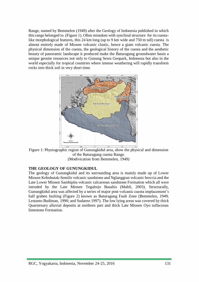
Range, named by Bemmelen (1949) after the Geology of Indonesia published in which
this range belonged to. (Figure 1). Often mistaken with synclinal structure for its cuesta-
like morphological features, this 24 km long (up to 9 km wide and 750 m tall) cuesta is
almost entirely made of Miosen volcanic clastic, hence a giant volcanic cuesta. The
physical dimension of the cuesta, the geological history of the cuesta and the aesthetic
beauty of panoramic landscape it produced make the Baturagung groundwater basin a
unique geosite resources not only to Gunung Sewu Geopark, Indonesia but also in the
world especially for tropical countries where intense weathering will rapidly transform
rocks into thick soil in very short time.
Figure 1: Physiographic region of Gunungkidul area, show the physical and dimension
of the Baturagung cuesta Range.
(Modivication from Bemmelen, 1949)
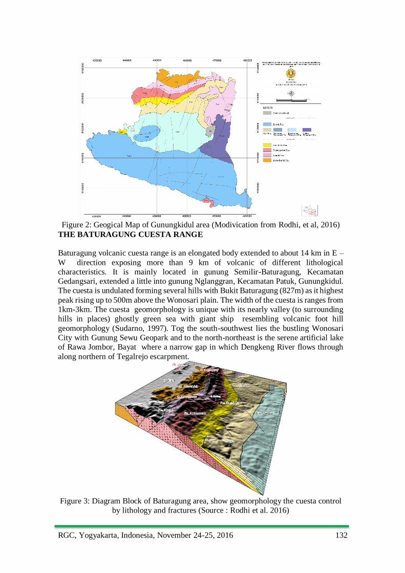
THE GEOLOGY OF GUNUNGKIDUL
The geology of Gunungkidul and its surrounding area is mainly made up of Lower
Miosen Kebobutak-Semilir volcanic sandstone and Nglanggran volcanic breccia and the
Late Lower Miosen Sambipitu volcanic calcareous sandstone Formation which all were
intruded by the Late Miosen Tegalrejo Basaltis (Mahfi, 2003). Structurally,
Gunungkidul area was affected by a series of major post-volcanic cuesta implacement’s
half graben faulting (Figure 2) known as Baturagung Fault Zone (Bemmelen, 1949;
Lestanto Budiman, 1990; and Sudarno 1997). The low lying areas was covered by thick
Quarternary alluvial deposits at northern part and thick Late Miosen Oyo tuffaceous
limestone Formation.
RGC, Yogyakarta, Indonesia, November 24-25, 2016 132
Figure 2: Geogical Map of Gunungkidul area (Modivication from Rodhi, et al, 2016)
THE BATURAGUNG CUESTA RANGE
Baturagung volcanic cuesta range is an elongated body extended to about 14 km in E –
W direction exposing more than 9 km of volcanic of different lithological
characteristics. It is mainly located in gunung Semilir-Baturagung, Kecamatan
Gedangsari, extended a little into gunung Nglanggran, Kecamatan Patuk, Gunungkidul.
The cuesta is undulated forming several hills with Bukit Baturagung (827m) as it highest
peak rising up to 500m above the Wonosari plain. The width of the cuesta is ranges from
1km-3km. The cuesta geomorphology is unique with its nearly valley (to surrounding
hills in places) ghostly green sea with giant ship resembling volcanic foot hill
geomorphology (Sudarno, 1997). Tog the south-southwest lies the bustling Wonosari
City with Gunung Sewu Geopark and to the north-northeast is the serene artificial lake
of Rawa Jombor, Bayat where a narrow gap in which Dengkeng River flows through
along northern of Tegalrejo escarpment.
Figure 3: Diagram Block of Baturagung area, show geomorphology the cuesta control
by lithology and fractures (Source : Rodhi et al. 2016)
RGC, Yogyakarta, Indonesia, November 24-25, 2016 133
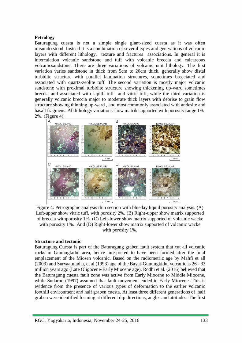
Petrology Baturagung cuesta is not a simple single giant-sized cuesta as it was often
misunderstood. Instead it is a combination of several types and generations of volcanic
layers with different lithology, texture and fractures associations. In general it is
intercalation volcanic sandstone and tuff with volcanic breccia and calcareous
volcanicsandstone. There are three variations of volcanic unit lithology. The first
variation varies sandstone in thick from 5cm to 20cm thick, generally show distal
turbidite structure with parallel lamination structures, sometimes brecciated and
associated with quartz-zeolite tuff. The second variation is mostly major volcanic
sandstone with proximal turbidite structure showing thickening up-ward sometimes
breccia and associated with lapilli tuff and vitric tuff, while the third variation is
generally volcanic breccia major to moderate thick layers with debrise to grain flow
structure showing thinning up-ward , and most commonly associated with andesite and
basalt fragmens. All lithology variations show matrik supported with porosity range 1%-
2%. (Figure 4).
Figure 4: Petrographic analysis thin section with blueday liquid porosity analysis. (A)
Left-upper show vitric tuff, with porosity 2%. (B) Right-upper show matrix supported
of breccia withporosity 1%. (C) Left-lower show matrix supported of volcanic wacke
with porosity 1%. And (D) Right-lower show matrix supported of volcanic wacke
with porosity 1%.
Structure and tectonic
Baturagung Cuesta is part of the Baturagung graben fault system that cut all volcanic
rocks in Gunungkidul area, hence interpreted to have been formed after the final
emplacement of the Miosen volcanic. Based on the radiometric age by Mahfi et all
(2003) and Suryaatmadja, et al (1993) age of the Bayat-Gunungkidul volcanic is 26 - 33
million years ago (Late Oligocene-Early Miocene age). Rodhi et al. (2016) believed that
the Baturagung cuesta fault zone was active from Early Miocene to Middle Miocene,
while Sudarno (1997) assumed that fault movement ended in Early Miocene. This is
evidence from the presence of various types of deformation to the earlier volcanic
foothill environment and half graben cuesta. At least three different generations of half
graben were identified forming at different dip directions, angles and attitudes. The first
RGC, Yogyakarta, Indonesia, November 24-25, 2016 134
generation is develop Kebo-Butak domino system, second develop Semilir horst
complex, and the last Semilir half graben. (Figure 5).
Figure 5: Ideal section Baturagung cuesta show half graben system which Kebo-Butak
Domino System in northern part, Baturagung Horst in central part and Semilir half
graben in southern part. (modivication from Fossen, 2010)
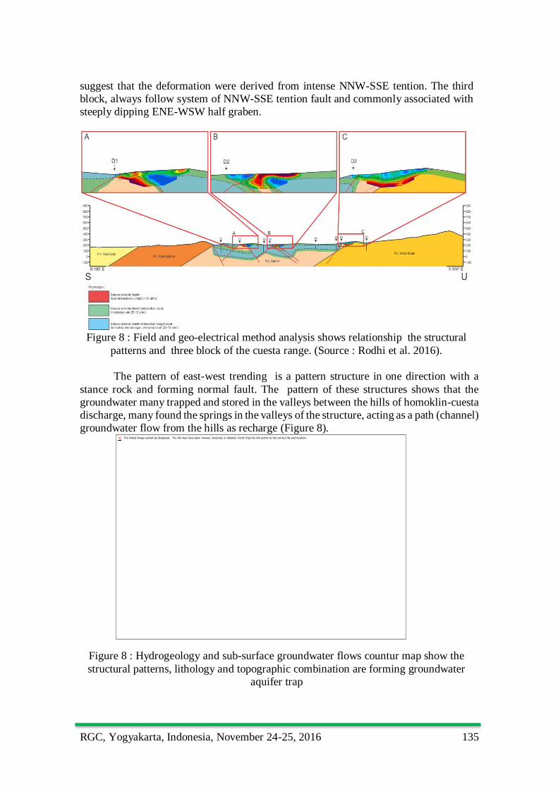
From prominent strike modes of fracture lineaments it can be interpreted that
Baturagung half graben cuesta has been produced .by horizontal tentional acting along
172o - 352o that were responsible for the Middle Miocene orogeny, and were still active
for quite sometimes after the emplacement of the volcanic cuesta (Figure 6).
Figure 6: Ideal Model half graben show Footwall collapse controlled by the presence
of weak layer from Wungkal Formation. (Rodhi et al, 2016, modivication from Fossen,
2010)
Hydrogeology
Field observations, resistivity geo-electrical, and Pole-dipole geo-electric method show
that not at all region have same faults pattern in the cuesta. In each block region
observation, they usually have several combinations of minor, meso and major faults
variation. (Figure 7). The first block, varies from minor, meso, major and nothing
fractures with fault plane generally steeply dipping to the SSE. Their fault plane ranging
from steeply to very steeply dipping and commonly associated with E-W half graben
faults. The second block varies from meso, minor and nothing fractures with fault plane
generally steeply dipping to the north or south. They are commonly called synthetic-
antitethic normal fault, and parallel with major fault. Transposition of layering during
deformation is not uncommon and the occurences of high-strain zone of horst fault
RGC, Yogyakarta, Indonesia, November 24-25, 2016 135
suggest that the deformation were derived from intense NNW-SSE tention. The third
block, always follow system of NNW-SSE tention fault and commonly associated with
steeply dipping ENE-WSW half graben.
Figure 8 : Field and geo-electrical method analysis shows relationship the structural
patterns and three block of the cuesta range. (Source : Rodhi et al. 2016).
The pattern of east-west trending is a pattern structure in one direction with a
stance rock and forming normal fault. The pattern of these structures shows that the
groundwater many trapped and stored in the valleys between the hills of homoklin-cuesta
discharge, many found the springs in the valleys of the structure, acting as a path (channel)
groundwater flow from the hills as recharge (Figure 8).
Figure 8 : Hydrogeology and sub-surface groundwater flows countur map show the
structural patterns, lithology and topographic combination are forming groundwater
aquifer trap
RGC, Yogyakarta, Indonesia, November 24-25, 2016 136
Landform and landscape
Differential weathering has been responsible in producing an undulating vertical cuesta
stood proudly above the background made of insitu volcanic sandstone soil with both
slopes are formed by collovium where volcanic sandstone soils and fractured are mixed
porosity together (Rodhi et al.,2016). That is a good secondary porosity and it was a
good aquifer, too. (Figure 8)
Figure 9: Sriten pond at southern slope of the top Baturagung cuesta an a good
porosity sample. Tog the south-southwest lies the bustling Wonosari City with Gunung
Sewu Geopark
The undulating nature of the cuesta is due to the formation of weak zone by later faults
that form several gaps including those cut by two main valley that are surrounding Bukit
Semilir, Bukit Baturagung and Bukit Nglanggran. At larger scale, the various peaks of
these landforms formed different morphological features such as dome, cuesta, half-
conical and hogback, (Figure 10)
Figure 10: The various peaks of these landforms formed different morphological
features such as dome, cuesta, half-conical and hogback
RGC, Yogyakarta, Indonesia, November 24-25, 2016 137
Heritage value and conservation
Rodhi et al., (2016) have pointed out several scientific, aesthetic and recreational values
for this cuesta and have propose it to be established as a geological monument, reservoir
and recreational reserves. At this moment part of this cuesta is located under the Forestry
Department Act as a State Park for conservation of rare wildlife and flora associated
with the volcanic cuesta. At present, the Gunungkidul State Government with supports
from various federal government agencies and academia have put their conserted efforts
in nominating this unique geoheritage site to the new geosite List..
SUMMARY
The Baturagung cuesta range is the longest visible volcanic cuesta in Indonesia and one
of the longest in the world. It is part of the half graben Baturagung Fault zone, made up
of a single cuesta with multiple fractures at volcanic lithology representing various stage
of the fault development. The formation of the entire cuesta represents a special event
in geological history where tectonic forces continue to take place long after the suturing
of two major plates. Deep tropical weathering exposed the cuesta to create a majestic
landscape and groundwater basin at the background of Wonosari city, Gunungkidul. Its
unique geomorphological features resembles cuesta landscape is a special feature of
tropical weathering. This volcanic cuesta should be preserved for its scientific
(geological) and aesthetic values as well as for its ecological values.
ACKNOWLEDGEMENT
The authors wish to thank ESDM Yogyakarta for financing the field expenses and all
Geology structural laboratory staff of the Geology Department,
REFERENCES
Achmad Rodhi, C. Preasetyadi, Jatmiko Setiawan,dan Puji Pratiknyo, 2016, Lapaoran
Pendahuluan Penyusunan Peta Geometri Cekungan Airtanah dan Peta Zona
Konservasi Airtanah, Kabupaten Gunungkidul, DIY, Dinas PUP dan ESDM
Christianasen and Hamblim, 2014, Planet Earth, Courtesy Of NASA, Florida, P. 516
Citra Selaras Mandiri., 2010, Pengeboran Sumur Dalam di Puring Suling, Desa Bandung,
Kecamatan Playen, Kabupaten Gunungkidul
Departemen Pendidikan Nasional Universitas Gadjah Mada Fakultas Teknik Jurusan
Teknik Geologi, 2002, Pedoman Teknis Pemetaan Zona Kerentanan Gerakan
Tanah Di Provinsi Daerah Istimewah Yogyakarta
Dinas PUP – ESDM D.I. YOGYAKARTA, 2015, Kontruksi Pembuatan Sumur Bor
Airtanah Dalam Paket 3 : Gunungkidul
Fossen Haakon, 2010, Struktural Geology, Cambridge University Press, P 457
Kementrian Energi Dan Sumber Daya Mineral Badan Geologi Pusat Sumber Daya
Airtanah Dan Geologi Lingkungan, 2015, Eksplorasi Dan Pelayanan Air Bersih
Melalui Pemboran Airtanah Dalam Paket SB – 6 Dusun Kampung Lor, Desa
Kampung, Kecamatan Ngawen, Kabupaten Gunungkidul
Kementrian Energi Dan Sumber Daya Mineral Badan Geologi Pusat Sumber Daya
Airtanah Dan Geologi Lingkungan, 2015, Eksplorasi Dan Pelayanan Air Bersih
Melalui Pemboran Airtanah Dalam Paket SB – 6 Dusun Mertelu Kulon, Desa
Mertelu, Kecamatan Gedangsari, Kabupaten Gunungkidul
Kementrian Energi Dan Sumber Daya Mineral Badan Geologi Pusat Sumber Daya
Airtanah Dan Geologi Lingkungan, 2013, Eksplorasi Dan Pelayanan Air Bersih
RGC, Yogyakarta, Indonesia, November 24-25, 2016 138
Melalui Pemboran Airtanah Dalam Paket SB – 16 Dusun Pulutan, Desa
Pulutan, Kecamatan Wonosari, Kabupaten Gunungkidul, DIY
Kementrian Energi Dan Sumber Daya Mineral Badan Geologi Pusat Sumber Daya
Airtanah Dan Geologi Lingkungan, 2013, Eksplorasi Dan Pelayanan Air Bersih
Melalui Pemboran Airtanah Dalam Paket SB – 16 Dusun Galih, Desa
Plembutan, Kecamatan Playen, Kabupaten Gunungkidul, DIY
Kementrian Energi Dan Sumber Daya Mineral Badan Geologi Pusat Sumber Daya
Airtanah Dan Geologi Lingkungan, 2013, Eksplorasi Dan Pelayanan Air Bersih
Melalui Pemboran Airtanah Dalam Paket SB – 16 Dusun Mengger, Desa
Karangasem, Kecamatan Paliyan, Kabupaten Gunungkidul, DIY
Kementrian Energi Dan Sumber Daya Mineral Badan Geologi Pusat Sumber Daya
Airtanah Dan Geologi Lingkungan, 2012, Eksplorasi Dan Pelayanan Air Bersih
Melalui Pemboran Airtanah Dalam Paket SB – 20 Dusun Sambeng II,
Kecamatan Ngawen, Kabupaten Gunungkidul, DIY
Kementrian Energi Dan Sumber Daya Mineral Badan Geologi Pusat Sumber Daya
Airtanah Dan Geologi Lingkungan, 2012, Eksplorasi Dan Pelayanan Air Bersih
Melalui Pemboran Airtanah Dalam Paket SB – 20 Dusun Salak, Desa Semoyo,
Kecamatan Patuk, Kabupaten Gunungkidul, DIY
Pemerintah Provinsi Daerah Istimewah Yogyakarta Dinas Pekerjaan Umum, Perumahan
Dan Energi Sumber Daya Mineral, 2011, Pemetaan Zonasi Konservasi Airtanah
Di Cekungan Airtanah Yogyakarta - Sleman
Pemerintah Provinsi Daerah Istimewah Yogyakarta Dinas Pekerjaan Umum, Perumahan
Dan Energi Sumber Daya Mineral, 2011, Penentuan Geometri Cekungan Dan
Konfigurasi Sistem Akuifer Airtanah Cekungan Yogyakarta – Sleman
Pemerintah Provinsi Daerah Istimewah Yogyakarta Dinas Pekerjaan Umum, Perumahan
Dan Energi Sumber Daya Mineral, 2011, Survey Investigasi Desain Pemboran
Air Sungai Bawah Tanah.
Pemerintah Provinsi Daerah Istimewah Yogyakarta Dinas Pekerjaan Umum, Perumahan
Dan Energi Sumber Daya Mineral, 2011, Survey Investigasi Desain Pemboran
Air Sungai Bawah Tanah.
Pemerintah Provinsi Daerah Istimewah Yogyakarta Dinas Pekerjaan Umum, Perumahan
Dan Energi Sumber Daya Mineral, 2015, Survey Investigasi Desain Sumur Bor
Produksi Airtanah Kecamatan Patuk dan Gedangsari, Kabupaten Gunungkidul,
DIY.
Pemerintah Provinsi Daerah Istimewah Yogyakarta Dinas Pekerjaan Umum, Perumahan
Dan Energi Sumber Daya Mineral, 2015, Survey Investigasi Desain Sumur Bor
Produksi Airtanah Kecamatan Nglipar, Karangmojo Dan Semin, Kabupaten
Gunungkidul, DIY.
Pemerintah Provinsi Daerah Istimewah Yogyakarta Dinas Pekerjaan Umum, Perumahan
Dan Energi Sumber Daya Mineral, 2016, Penyusuan Peta Zona Pengambilan
Dan Pemanfaatan Airtanah Di Kabupaten Kulonprogo
Pemerintah Provinsi Daerah Istimewah Yogyakarta Dinas Pertambangan, 1996-1997,
Pekerjaan Penyusunan Rencana Zona Tata Guna Air Bawah Tanah Di
Kecamatan Gedangsari, Karangmojo, Ngawen, Nglipar, Patuk, Ponjong dan
Semin Kabupaten Gunungkidul Bagian Utara, DIY
Pemerintah Provinsi Daerah Istimewah Yogyakarta Dinas Pertambangan, 1998-1999,
Pekerjaan Penyusunan Rencana Zona Tata Guna Air Bawah Tanah Di
RGC, Yogyakarta, Indonesia, November 24-25, 2016 139
Kecamatan Rongkop, Semanu Dan Tepus, Kabupaten Gunungkidul Bagian
Utara, DIY
Pemerintah Provinsi Daerah Istimewah Yogyakarta Dinas Pertambangan, 1999-2000,
Pekerjaan Penyusunan Rencana Zona Tata Guna Air Bawah Tanah Di
Kabupaten Gunungkidul Bagian Barat Selatan Kecamatan Panggang, Paliyan,
Dan Saptosari, DIY
Pemerintah Provinsi Daerah Istimewah Yogyakarta Badan Pengembangan Perekonomian
Dan Investasi Daerah, 2002, Penelitian Zona Tata Guna Air Bawah Tanah Di
Kecamatan Wonosari Dan Kecamatan Playen Kabupaten Gunungkidul Bagian
Tengah, DIY