Embed Size (px)
Citation preview

REVOLUTION UNDERWAY – GIS AND EMERGENCY MANAGEMENT IN MINNESOTA
Stephen D. Swazee, Sr.Emergency Preparedness Committee,
Minnesota Statewide Geospatial Advisory Council, 4524 Oak Pond Road, Eagan, MN 55123
EXECUTIVE SUMMARY
In recent years, the U.S. government has spent billions to improve situational awareness for the emergency management and first response communities. Unfortunately, in many cases these expenditures have failed because they do not adequately address the pivotal role state-basedgeospatial efforts must play in developing national capacity and interoperability. Consequently, inconsistent and poorly focused state-based geospatial support of the nation’s emergency response community is largely the norm. There are exceptions, however, with the Emergency Preparedness Committee (EPC) of Minnesota’s Statewide Geospatial Advisory Council, serving as an example of what is possible from “state partners”. Starting with a membership of 17 in fall 2007, the EPC now stands at 200 as volunteers from Minnesota’s geospatial and emergency services communities have come together to develop better situational awareness products for emergency response. These very thinly funded collaborative efforts have produced unique and powerful results: national leadership in U.S. National Grid implementation, development of powerful Common Operating Pictures for the Republican National Convention and 2009 Red River Valley flooding, creation of “state-endorsed” geospatial data layers, and much more. Thus, to align national situational awareness needs, with a plan, federal money must be directed at creating and supporting these types of state-based efforts.
BACKGROUND
Following 9/11 and accelerating post Katrina, the Federal government began a series of initiatives to develop collaborative systems to support disaster planning and response. Central to these efforts have been Geographic Information Systems (GIS) and affiliated approaches such as Integrated Common Analytical Viewer (iCAV), Homeland Security Information Network (HSIN), Homeland Security Infrastructure Program (HSIP), Hazard US-Multi-Hazard (HAZUS-MH), Palanterra, Homeland Infrastructure Foundation Level Working Group (HIFLD), Geospatial Data Model (GDM), Constellation/Automated Critical Asset Management System (C/ACAMS), DHS-Earth, and Virtual USA. Although these geospatial efforts as championed primarily by the Department of Homeland Security (DHS) have gone a long way towardsbuilding a framework of geospatial interoperability that supports emergency preparedness and response - much like the Internet serves as the conduit for bringing together individual computers from around the globe – effective, wide-area, situational awareness during disaster response remains largely an unrealized and elusive goal.
Fundamental to this failure has been the inability of the national security decision makingprocess to fully conceptualize that technology is only part of the answer when it comes to situational awareness for emergency preparedness and response. More exactly, while money has
been spent with abandon on a broad range of federally directed visualization technologies and support1, there exists no DHS program of dedicated financial support for state-based efforts to develop the people part of the geospatial equation2. And without an inclusive community of state and local partners who are willing and capable of enabling information exchange, and acorresponding framework to support those efforts, spending further sums on a federally driven “situational awareness Internet” for emergency response is of questionable value outside the federal community.
In stark contrast to this situation is the reality that well before 9/11, other parts of the federal government had become keenly interested in ensuring the accuracy and efficiency of the nation’s cadastral data through collaboration with state and local partners. As a result, OMB Circular A-16 of 1990 created the Federal Geographic Data Committee (FGDC); while Executive Order 12906 of 1994 gave it responsibility for the National Spatial Data Infrastructure (NSDI). By definition, the National Spatial Data Infrastructure is, “the technologies, policies, and peoplenecessary to promote sharing of geospatial data throughout all levels of government, the private and non-profit sectors, and the academic community.”3 Consequently, in support of this vision that geospatial awareness is not simply a top-down technology implementation issue, but also a grass-roots up data enablement issue (by people and policies), the FDGC has used its minimalist funding stream to support both approaches.
It’s a viewpoint that DHS and other federal homeland defense, security and response programs could learn from. To that end, the Emergency Preparedness Committee (EPC) of Minnesota’s Statewide Geospatial Advisory Council serves as an example of the upside potential for national interoperability and situational awareness if funding were made available to commence andmaintain similar state-based programs.
THE EMERGENCY PREPAREDNESS COMMITTEE
Initially created in 2002 as a result of a Minnesota geospatial community’s desire to contribute to state preparedness and security following 9/11, the EPC remained relatively small and only marginally effective until fall of 2007. At that point, new leadership with experience in the emergency management and response worlds opted to aggressively grow the committee through extensive outreach, including recruitment of individuals from the state’s emergency services sector. By February 2010, membership had grown from 17 to 200, with 70 individuals 1 Because of differing approaches to budget construction, and assignment of responsibility for these technologies to a variety of internal organizations since the inception of DHS, determining exact expenditures is problematic. However, in FY2010 alone, the combined discretionary budget for the four DHS tenant entities with stated missions in this arena – FEMA, Analysis and Operations, National Protection and Programs Directorate and the Science and Technology Directorate was $10.04 billion. 2 To its credit, DHS through its operational programs has attempted to move the federal community in the direction of a more collaborative and efficient flow of geospatially enabled information. Creation of state fusion centers and the release of the Federal Interagency Geospatial Concept of Operations are examples in this regard. Unfortunately, these efforts are focused primarily on federal law enforcement and internal geospatial “house-cleaning” and not on the broad based outreach and collaboration necessary to successfully engage local, regional and state geospatial resources. 3 http://www.fgdc.gov/nsdi/nsdi.html, accessed January 20, 2010

volunteering their time as part of five work groups covering education, outreach, geospatial response, data and Next Generation 9-1-1. But beyond creating a collaborative environment that extends both horizontally and vertically into the geospatial and emergency services sectors, this unfunded, bottom-up, people-based approach for bringing geospatial technology to the emergency preparedness and response communities has developed some unique concepts that are worthy of consideration on a national level:
DashboardingOne of the principal values of geospatial data is the ability to boil down large volumes of data into something visually understandable. Figure one represents an example of this concept as created by the EPC:
Figure 1.
Based on the SWEAT infrastructure acronym attributed to Florida Emergency Management, this simplistic example of geospatially related data, has value on the state and local level in a number

of ways beyond simply serving to “dashboard” reams of disaster related textual informationnormally found in “sitreps”:
For the decision makers and responders with little or no experience in the geospatial world, it can serve as the starting point for discussions on how to effectively move institutions and procedures into alignment with the Common Operating Picture (COP) approach required by the National Response Framework (NRF) and National Incident Management System (NIMS).
For the geospatial community with little or no experience in the emergency response world, it can serve as the starting point for understanding that while all geospatial data is important during disasters, there are ways to tailor the universe of possibilities4 so that it is relevant to a particular community – in this case, the decision makers.
For both, it can serve as the starting point in understanding that each must work with the other to create a relevant, uniform flow of information that allows geospatial technology to deliver situational awareness during disasters.
DataWhile the dashboard concept as described above is a way to geospatially visualize the status of infrastructure, it fails to provide the granularity required by the response community. Two additional components must be added to achieve that specificity – exact location and attributes of the site. Aware that the federal government’s efforts to share this type of geospatial information are principally focused on creating systems to harvest existing data bases via technology intense methods, the EPC and Minnesota Geospatial Information Office (MnGeo) applied for, and received, a $50,000 grant from the FGDC’s 2008 Cooperative Grants Program (CAP) for the purposes of creating source data by engaging people. Mindful that many rural counties in Minnesota do not have any dedicated geospatial capacity, and that some urban areas won’t share geospatial data unless it is paid for, the EPC’s Minnesota Structures Collaborative work group developed a simple to use, online system that allows local emergency response and geospatial personnel to populate the where and what of four critical emergency response layers: schools, hospitals, police and fire stations.
Furthermore, realizing that local data, and not platform, is central to achieving a national COP, output from the system has been specifically designed so that it can feed The National Map, HSIP, C/ACAMS, Firewise and several other geospatial data bases of value to the federal government, as well as those maintained by various state, regional and local entities. Consequently, this approach not only supports the NSDI, but it gives the emergency preparedness and response communities ownership of the way to develop “ground truth” for their efforts.
As an example of this concept, Figure 2 below is a screen shot that shows how an individual can input data and refine one of the “state endorsed” data layers in the Minnesota Structures Collaborative Online System:
4 As an example, HSIP Gold has 340 data layers

Figure 2.
The Basic MapThe world’s best data is inherently useless without a way to display it. But instead of seeing this issue as a technology discussion framed by the merits of one geospatial platform or hand-held over another, the EPC has developed an encompassing approach driven by standards. To that end, the standard is the U.S. National Grid (USNG).
Developed by the Federal Geographic Data Committee, and endorsed by FEMA and the National Search and Rescue Committee, the USNG is an easy to use system for identifying and determining location with a USNG gridded map and/or USNG enabled Global Positioning System (GPS) receiver. Based on techniques used by the military for more than 50 years, it offers an inexpensive way for the general public and all components of the emergency response community to have a common geospatial frame of reference while serving as an “always ready” backup for high-tech systems. Effectively, the USNG interlocks Geographic Information Systems (GIS), GPS and the basic hand map in a way that creates a uniform, easy-to-use methodology for quickly geo-locating points with a high degree of accuracy.
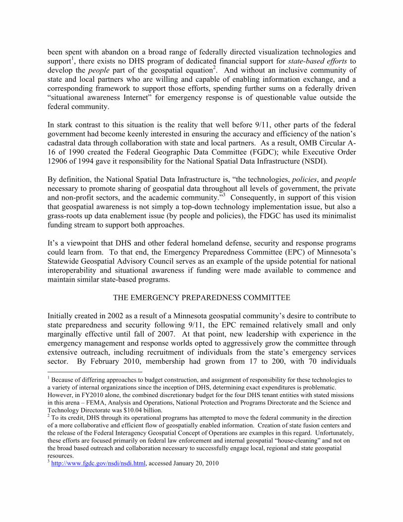
Figure 3 below shows an example of the point-click-print USNG map library module deployed as part of the previously described Minnesota Structures Collaborative online system:
Figure 3.
By using this system, Minnesota’s emergency services communities now have 24/7 access to basic 1:24,000 paper products that cover the entire state. Other advantages of this nationally unique approach include:
Should local efforts require outside assistance, there is a uniform product immediately available for distribution as additional responders join the effort.
Use of this standard product approach enables constant and consistent update of event information on paper map products as a disaster response unfolds.
By using this standardized USNG approach, remote generation of geospatial products in support of a response become possible. Consequently, no community – even those without the funds to have dedicated GIS support as part of their government structure –will ever be without mapping support during a disaster.
Go TeamFollowing the I-35W bridge collapse in August 2007, antidotal evidence suggested some form of state-sponsored geospatial task force should be created to respond to future Minnesota disasters. Consequently, in January 2008, the EPC began training a GIS Go Team of volunteers from its membership. Patterned after previous efforts by organizations such as the U.S. Forest Services for wildfires, and the National Geospatial Agency for National Special Security Events, a select team of nine members was first used at the United States Secret Service’s Multi Agency Communication Center during the Republican National Convention of September 2008. Subsequently, spring flooding in the Red River Valley during 2009 triggered involvement of over 30 EPC volunteers as the initial Go Team concept of location-based state support evolved into one of virtual workspaces, collaborative tools, remote map production, and an expanding

role in efforts to maintain situational awareness during the disaster. And since these efforts were underway weeks before DHS geospatial support arrived at either the state Emergency Operations Center or Joint Operations Center, they once again serve example of how state-based geospatial efforts focused on people can substantially contribute to national readiness and response goals.
CONCLUSION
The accomplishments of the EPC as briefly described in this paper are only part of a much larger effort that also includes: development of a emergency management training program for geospatial professionals, creation of imagery and mapping request forms and associated procedures, ongoing work that will allow Civil Air Patrol ARCHER imagery to be harvested and quickly distribute during disasters, and much more that directly benefits the nation’s ability to implement situational awareness through geospatial technology. Total cost to the federal government to date: zero.5 Yet on balance, these accomplishments represent an upside potentialfor national situational awareness, which if replicated by similar programs in all the states, is clearly worthy of federal financial support. Consequently, DHS and other federal partners in the homeland security, preparedness and response realms, need to move beyond seeing geospatial technology as an end all, and onto an understanding that state-based efforts focusing on people and policies are of equal value.
5 All funds received for the CAP grant were retained by MnGeo to pay internal project costs.
References:
2008 Republican National Convention: http://www.gopconvention.com/C/ACAMS: http://www.dhs.gov/xinfoshare/programs/gc_1190729724456.shtmCAP Archer System: http://atg.cap.gov/downloads/FINAL%20VERSION%20ARCHER%20Technical%20Fact%20Sheet.pdfDHS-Earth: http://www.nsgic.org/hottopics/DHS_Earth.pdfExecutive Order 12906: http://www.archives.gov/federal-register/executive-orders/pdf/12906.pdfFEMA’s Geospatial Intelligence Specialist Job Aid:http://www.learningservices.us/fema/taskbooks/files/GeoIntelSpecialistJobAid.pdfFGDC: http://www.fgdc.gov/ andhttp://www.fgdc.gov/library/whitepapers-reports/white-papers/homeland-security-gisFGDC CAP Grants: http://www.fgdc.gov/grants/index_html/?searchterm=cap grantsFreedom Web: https://www.freedomwebdata.com/public/GDM: http://www10.giscafe.com/nbc/articles/view_weekly.php?articleid=581749&page_no=1HAZUS-MH: http://www.fema.gov/plan/prevent/hazus/index.shtmHIFLD: http://www.hifldwg.org/HSIN: http://www.dhs.gov/files/programs/gc_1156888108137.shtmHSIP: http://www.fgdc.gov/participation/steering-committee/meeting-minutes/may07/hsipiCAV: http://www.dhs.gov/xinfoshare/programs/gc_1217445858859.shtmMinnesota DNR Firewise: http://www.dnr.state.mn.us/firewise/link.htmlMinnesota Division of Homeland Security and Emergency Management: http://www.hsem.state.mn.us/Minnesota Geospatial Information Office: http://www.mngeo.state.mn.us/MN SGAC Emergency Preparedness Committee: http://www.gis.state.mn.us/committee/emprep/Minnesota Structures Collaborative:http://www.mngeo.state.mn.us/committee/emprep/structures/index.htmlThe National Map: http://nationalmap.gov/National Wildfire Coordinating Group, GIS Standard Operating Procedures on Incidents: http://www.nwcg.gov/pms/pubs/GSTOP7.pdfNSDI: http://www.fgdc.gov/nsdi/nsdi.htmlNIMS: http://www.fema.gov/emergency/nims/NRF: http://www.fema.gov/emergency/nrf/OMB Circular A-16: http://www.whitehouse.gov/omb/rewrite/Circulars/a016/a016_rev.htmlPalanterra: http://www1.nga.mil/Newsroom/Pathfinder/0605/Pages/Palanterra.aspxU.S. Fire Administration/Technical Report Series, I-35W Bridge Collapse and Response: http://efoponline.net/downloads/pdf/publications/tr_166.pdfUSNG: http://www.gis.state.mn.us/committee/emprep/download/USNG/index.htmlVirtual USA: http://www.dhs.gov/ynews/releases/pr_1260375414161.shtm


![OpenTextsontheWeb, TakingtheNextStep · Revolution to Evolution As noted by Steven E. Barkan [3] in his Notices piece, there is a revolution underway. Books both new and old are migrating](https://img.dokumen.tips/doc/110x75/5fee7239cab05f743c59718b/opentextsontheweb-revolution-to-evolution-as-noted-by-steven-e-barkan-3-in-his.jpg)