Embed Size (px)
Citation preview

Revised
2016
Association of Newfoundland Land Surveyors 62-64 Pippy Place, Suite 203
St. John’s, NL A1B 4H7 709-722-2031 709-722-4101 www.anls.ca
Standards of Professional Conduct, Knowledge and Skill
Rev
ised
20
16
2
Standards of Professional Conduct, Knowledge and Skill
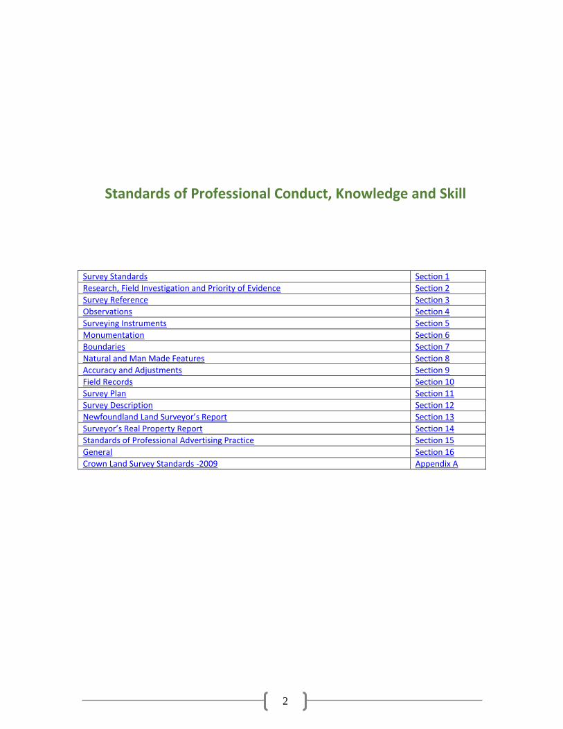
Survey Standards Section 1
Research, Field Investigation and Priority of Evidence Section 2
Survey Reference Section 3
Observations Section 4
Surveying Instruments Section 5
Monumentation Section 6
Boundaries Section 7
Natural and Man Made Features Section 8
Accuracy and Adjustments Section 9
Field Records Section 10
Survey Plan Section 11
Survey Description Section 12
Newfoundland Land Surveyor’s Report Section 13
Surveyor’s Real Property Report Section 14
Standards of Professional Advertising Practice Section 15
General Section 16
Crown Land Survey Standards -2009 Appendix A
3
1. Survey Standards
1.1 All Land Surveying is to be completed in accordance with the Land Surveyor’s Act, the Regulations and the By-Laws of the Association. When performing work for any Provincial or Federal Agency, where there may be inconsistencies between the aforementioned By-Laws and any Provincial or Federal Surveying requirements, the more rigorous standards shall apply.
2 Research, Field Investigation and Priority of Evidence
2.1 During the performance of a survey for a parcel of land, the following procedures shall be observed:
2.2 Before undertaking a survey, the Newfoundland Land Surveyor shall thoroughly research
the documentary evidence related to the land under survey and the land adjoining the land under survey, which may include any or all of the following:
2.2.1 a search of the Registry of Crown Lands; 2.2.2 a search of the Registry of Deeds including the master plan index; 2.2.3 a search of his own files for related Survey plans or plans thereof; 2.2.4 a search of the applicable files of fellow Newfoundland Land Surveyors; 2.2.5 a search of other documentary evidence, i.e. City or Town Engineering Plans,
Utility Company Easements and Right-of-Way plans, etc.; 2.2.6 Contacting adjacent property owners to determine if any written or verbal
agreements exist which may affect the property; 2.2.7 search of LandGazette.
2.3 A Newfoundland Land Surveyor shall carry out an exhaustive field investigation for the
best available evidence of all boundaries, lines and corners and give priority to the evidence in accordance with Common Law and Statute Law.
NOTE: A study of Case Law will show that the priority of evidence is as follows:
2.3.1 Natural Boundaries; 2.3.2 Original monuments or evidence as to the location of original monuments;
2.3.2.1 Even after a monument is found, a Newfoundland Land Surveyor should not lightly assume that it is the authentic original monument or for that matter that it is in the position in which it was originally placed.
2.3.3 Fences or possession reasonably dating back to the creation of the boundary, limit or corner;
2.3.4 Other limits as called for in the deeds; 2.3.5 Measurements as contained in deeds or as shown on the survey plan or plans.
2.4 Coordinate values are deemed to be measurements.
3 Survey Reference
3.1 Surveys are to be tied or referenced to the Provincial geographical referencing system by
direct survey connection to Provincial monuments, where possible.
4
3.2 The general rule is to reference the survey to the provincial Geographical Referencing System if the survey is within a distance of twenty (20) kilometers from Provincial Monuments.
3.3 The current Provincial geographic referencing system is based on the North American
Datum 1983 “NAD83” and the Modified Three Degree Transverse Mercator Projection for Newfoundland.
3.4 Where the survey cannot be tied to the reference system, it will be tied to two permanent
features or objects such as fire hydrants, bridges, etc., and to two photo identifiable points, where possible, and the distance between the two points should be measured and recorded. When features such as bridges are used, a spike or iron bar must be used to mark the exact location of the control point. It should be possible to relocate these points at any time without doubt or uncertainty. If two suitable permanent features or objects cannot be found in the vicinity of the survey, two local control monuments must be established and properly referenced in the field notes.
3.5 North reference should be Provincial Grid North. 4 Observations
4.1 All angles shall be measured with a theodolite, total station, or instrument of comparable accuracy.
4.2 Distances between intervisible stations, longer than 100 meters, shall be measured by
electronic distance measuring instruments. For distances less than 100 meters, a standard steel tape may be used. Chained distances are to be measured twice.
4.3 Coordinates established on a monumented property corner by means of a side-shot must
be verified by an independent check measurement, where practical. When it is not practical to get a second independent check measure, a note should be added in the field book explaining the situation and the second angle and distance shall be measured from the traverse setup.
4.4 GNSS SURVEYS AND GUIDELINES:
4.4.1 Interconnecting baselines forming a closed traverse shall be used when using
static surveying methods. 4.4.2 Four or more common satellites with acceptable geometric configuration (no less
than ten degrees above the horizon) shall be used. 4.4.3 H.I. is to be measured carefully and recorded in a field book as a check for post
processing. 4.4.4 Field notes should document data collection parameters. 4.4.5 Property corners established by a radial method shall be checked by one or more
of the following: 4.4.5.1 Radial tie from another known station 4.4.5.2 Independent measurement by conventional survey methods 4.4.5.3 Comparison with a previous survey 4.4.5.4 Point re-occupation with separate observation parameters and
independent initialization
5
5 Surveying Instruments
5.1 All instruments are to be in proper adjustments, operating in an accurate and reliable manner and used according to the manufacturer’s procedure.
5.2 Theodolites must be read direct to 5 seconds or better.
6 Monumentation
6.1 A monument is defined as an officially capped iron bar set securely in the ground (since October 1, 2003).
6.2 All property corners shall be monumented, where possible. 6.3 In cases where an official monument can’t be used, a note must be added to the drawing
indicating how the corner is marked (e.g. nail, spike, fence post, witness post). 7 Boundaries
7.1 In open areas, the Newfoundland Land Surveyor shall mark out the boundary by placing stakes on line at intervals not exceeding 50 meters, so as to give evidence of a surveyed line. In wooded areas, the Newfoundland Land Surveyor shall mark out the boundary by cutting a clear line through the woods.
7.2 The position of a natural boundary that forms a boundary of the land being surveyed or
that governs the position of that boundary shall be determined by:
7.2.1 Measurements adequate to determine all its irregularities and to enable its relocation.
7.2.2 Where inaccessibility of a natural boundary makes measurements of its irregularities impossible, the location of this boundary may be determined by using aerial photographs and/or topographic maps at a suitable scale and a note indicating where information was derived.
7.3 In the case of water boundaries, except where applicable legislation, judicial decisions or
existing rights are to the contrary, use the “ordinary high water mark” of the feature to determine the boundary.
8 Natural and Man-Made Features
8.1 All water bodies, buildings, fences, power lines, and any other prominent natural and man-made features pertaining to the survey shall be tied in. If inaccessibility of natural features such as water bodies make measurements impossible, the location of these features may be determined form aerial photographs and/or topographic maps at a suitable scale.
9 Accuracy and Adjustments
9.1 Adjust all observed angles in closed loops or between Provincial control monuments. Use adjusted angles to determine the azimuths of courses and loop closures. Angular
6
misclosure before adjustment shall not exceed 20 times the square root of N seconds (where N = number of angles).
9.2 Maximum allowable misclosure in an unadjusted traverse is 0.03m + .0001 x D (where D
=distance traversed in meters). 9.3 After proper accuracies are reached, all traverses and / or surveys shall be adjusted using
and acceptable method of adjustment such as Least Squares Method, Crandall Method or Compass or Transit Rule.
9.4 When using GNSS equipment for determining co-ordinates on Property Corners,
observation procedures should be met on all Property Corners with an accuracy of 3 cm. (e.g. Crown Land Standards: Property Corners to be measured from 2 setups).
10 Field Records
10.1 Field records either in digital or hard-copy format or combination of both are to contain a clear, detailed account of everything found, observed and done in the course of the survey.
10.2 Field records either in digital or hard-copy format or combination of both are to be written
or recorded at the time of observation and never from memory or scratch notes.
10.3 All field records either in digital or hard-copy format or combination of both are to be preserved for possible future reference. A hard-copy of the digital records should be printed immediately upon downloading to the computer.
10.4 Do not obliterate any entry in the field records. Stroke out incorrect entries in such a way
that they remain legible but are obviously discarded. In the case of digital information, devise some method of indicating or identifying a discarded field note.
11 Survey Plan
11.1 The Survey Plan shall include but is not limited to the following:
11.1.1 a straight line azimuth/bearing and horizontal ground distance or grid distance from one of the provincial survey control markers to a property corner, being the point of commencement for the survey or the Newfoundland 3 degree Modified Transverse Mercator projection Coordinate values NAD83 Datum of such point of commencement.
11.1.2 the Newfoundland 3 degree Modified Transverse Mercator Projection Coordinate values (NAD83) and the Zone number or Central Meridian for any Provincial control monuments used;
11.1.3 reference for any local control monuments, reference markers, features or objects used for the tie-in, where applicable;
11.1.4 adjusted azimuths/bearings of all boundary lines in degrees, minutes and seconds; 11.1.5 adjusted horizontal ground distances expressed in meters to three decimal places; 11.1.6 a note indicating the type of linear measurements used if not horizontal ground; 11.1.7 north arrow; 11.1.8 transportation corridors, water bodies and cut lines; 11.1.9 location and extent of reserves, i.e. roads, etc.;
7
11.1.10 scale of survey plan; 11.1.11 the position of all monuments set; 11.1.12 the location and extent of every apparent right of way and easement affecting the
land, either registered or evident on the ground; 11.1.13 the names of all adjacent landowners or claimants and the corresponding registry
information when possible; 11.1.14 symbols for all monuments found or set; 11.1.15 plans must be dated; 11.1.16 when an irregular natural feature (i.e. water body, etc.) forms or references a
boundary, straight line azimuth/bearing and distance from one end of this boundary to the other;
11.1.17 the radius arc, chord length and chord azimuth bearing of each circular curve forming any boundary or part of any boundary;
11.1.18 areas of properties must be expressed in hectares rounded to three (3) decimals points or square metres rounded to no more than one decimal point;
11.1.19 any visible encroachments of fences, buildings or other structures or fixtures from the land being surveyed onto adjacent lands and from adjacent lands onto the lands being surveyed;
11.1.20 a note stating that there is an accompanying Newfoundland Land Surveyors report, if applicable;
11.1.21 the Copyright notice will be shown on survey plans: ©_________ Newfoundland Land Surveyor, “YEAR”. Unauthorized use, alteration or reproduction of this survey and its attached survey description is prohibited by law as outlined in the Copyright Act and Land Surveyors Act. However, use and reproduction thereof by or on behalf of the person, for whom this survey plan and description were prepared, is permitted, provided that no alterations whatsoever are made thereto;
11.1.22 where necessary enlarged sections may be used for clearer illustration. 11.1.23 With the adoption of microfilming procedures at the Registry of Deeds, it is
important that the plan be drawn on sheets 21.5cm x 28cm, 21.5cm x 35.5cm, or 28cm x 35.5cm. The 28 x 35.5 size should only be exceeded if the necessary information cannot be fitted in this format.
11.1.24 The survey plan shall be produced on good quality medium. 11.1.25 All lettering shall be easily readable when viewed upwards from the bottom edge
of the survey plan. 11.1.26 The survey plan shall be plotted or drafted with the line color of black in either
black indie ink or the product of a plotting or printing device. 11.1.27 The survey plan shall be drawn to a professional standard or draftsmanship which
will allow neat, clear, legible reproductions. 11.1.28 All lettering to be drawn using mechanical or electronic lettering equipment or
computer aided software packages. 11.1.29 Each print of the survey plan shall be individually signed and stamped. 11.1.30 The color of ink used for the stamp and signature shall be of any color other than
black. 12 Survey Description
12.1 A clearly worded metes and bounds description, prepared on 21.5cm x 28cm or 21.5cm x 35.5cm paper, shall include, but not be limited to, the following:
12.1.1 Locality of the survey
8
12.1.2 Local control monuments, reference markers, features or objects used for the tie, if applicable;
12.1.3 The reference meridian; 12.1.4 Survey area 12.1.5 Any apparent easements, right-of-ways; 12.1.6 The names of all adjacent landowners or claimants and the corresponding registry
information when possible. 12.1.7 Reference must be made to the accompanying survey plan 12.1.8 Date of survey plan 12.1.9 A note if linear measurements are other than horizontal ground distances; 12.1.10 The Newfoundland 3 degree Modified Transverse Mercator Projection Coordinate
values (NAD83) for the point of commencement of the survey description, if applicable
12.1.11 Sufficient information to mathematically close the parcel; 12.1.12 The radius, arc, chord length and chord azimuth/bearing of each circular curve
forming any boundary and indicate whether the curve is clockwise or counter clockwise;
12.1.13 Grid reference and the appropriate datum. 12.1.14 Each print of the survey plan shall be individually signed and stamped. 12.1.15 The color of ink used for the stamp and signature shall be of any color other than
black.
13 Newfoundland Land Surveyor’s Report
13.1 If obvious problems or contentious issues are found to exist during the course of the survey, a written Newfoundland Land Surveyor’s Report must be provided to the client to draw his attention to all such problems and issues. A copy of this report must be placed in the clients file for possible future reference.
14 Surveyors Real Property Report
14.1 A Surveyor’s Real Property Report shall not be completed without reference to a Survey Plan of the property for which the report is being completed. Such survey plan to be up to the current minimum standards as set in these standards and to within a maximum of 10 years after the date of the survey.
14.2 The Newfoundland Land Surveyor in completing his Surveyors Real Property Report shall:
14.2.1 Verify all necessary measurements; 14.2.2 Show the current status of the land with respect to all apparent visible
encroachments, easements or rights-of-way; 14.2.3 Show the current status of the land with respects to additions or deletions to the
size of the land, which shall constitute a new survey; 14.2.4 Identify all structures on the land. Dimensions and side yard measurements for all
major structures will be shown on the Surveyor’s Real Property Report plan; 14.2.5 Identify the Newfoundland Land Surveyor and the date of the survey as shown on
the Survey Plan in Section 15, Subsection 15.1 of this By-Law, where possible; 14.2.6 Include the following note “This plan certifies the information as of ‘DATE’, and
only as of ‘DATE’”; 14.2.7 Show the address of the property displayed, where applicable; 14.2.8 Show the evidence of boundaries and previous survey monumentation recovered;
9
14.2.9 Show fully dimensioned boundaries (bearing and distance) of the survey enclosing the property;
14.2.10 Verify the point of commencement as defined in Section 12, subsection 12.1.1, used in the initial survey plan;
14.2.11 Show adjoining property owners and or property identification number, where practical;
14.2.12 Show all driveways, right-of-way or other methods of access to the property; 14.2.13 Provide a typed Surveyors Real Property Report with reference to an identifiable
accompanying Surveyors Real Property Report Plan; 14.2.14 Stamp and sign the integral parts of the Surveyors Real Property Report, prepared
by the Newfoundland Land Surveyor, in any other color than black; 14.2.15 The Surveyors Real Property Report shall clearly show the title to be “Surveyors
Real Property Report”; 14.2.16 The Copyright Notice will be shown on the typed portion of the Surveyors Real
Property Report and on the accompanying Surveyors Real Property Report Plan as follows: _____________ Newfoundland Land Surveyor, “YEAR”. Unauthorized use, alteration or reproduction of this Surveyors Real Property Report is prohibited by law as outlined in the Copyright Act and the Land Surveyor’s Act. However, use and reproduction thereof by or on behalf of the person to whom this report is certified, is permitted, provided that no alterations whatsoever are made thereto;
14.2.17 Note that there are no apparent easements or encroachments, if applicable; 14.2.18 The latest format of the Surveyors Real Property Report, approved by the Council
of Management, will be followed by the membership.
14.3 While preparing a Surveyor’s Real Property Report, the Newfoundland Land Surveyor should follow the procedure as outlined in Section 2 of these Standards.
14.4 A Surveyors Real Property Report shall not be performed upon any real property without
significant physical evidence of the survey being portrayed in the reference survey plan.
15 Standards of Professional Advertising Practice
15.1 The following are the Standards of Professional Advertising Practice by which all classes of members of the Association of Newfoundland Land Surveyors are bound in the conduct of their survey business.
15.2 Unless the context otherwise requires:
15.2.1 “consumer” means a person who is or may be in a position to acquire or need the
services of a land surveyor; 15.2.2 “member” means a member of the Association as defined in the Land Surveyors
Act (1991}) and includes a group, association, firm or partnership of members and any other arrangement between two or more members and includes a student and a corporation holding a Certificate of Authorization;
15.2.3 “providing information” includes: 15.2.3.1 An advertisement 15.2.3.2 Any publication or communication in any medium with
any client, prospective client or the public generally in the nature of an advertisement, promotional activity or material, a listing in a directory, announcement, brochures, business cards, signs, a
10
public appearance or any other form or means by which land surveying services are promoted;
15.2.3.3 Contact with a prospective client initiated by a member. 15.2.4 “firm” means any sole proprietor, partnership, group, firm or association of two or
more persons carrying on the practice of land surveying in Newfoundland Labrador and includes a corporation holding a Certificate of Authorization.
15.3 This section of the Standards shall be interpreted in a manner which recognizes that a
member may, in any medium of communication, undertake or authorize any provision of information respecting his or her land surveying services which is factual, accurate, verifiable, in good taste, not misleading and is compatible with the respected status and reputation of the Association and the practice of land surveying.
15.4 A member may provide information in relation to land surveying services to any person
either in person or in writing provided that the provision of information is in accordance with this section of the Standards and provided that the provision of information is not persistent or harassing.
15.5 A member shall not provide information in relation to land surveying services that:
15.5.1 Compares either directly or indirectly the member’s services or abilities with the services or abilities of another member;
15.5.2 Creates an unreasonable expectation about the nature or extent of services to be performed;
15.5.3 Is misleading or deceptive or is likely to mislead or deceive; 15.5.4 Contains any testimonials or endorsements concerning the member; 15.5.5 Discloses the names of the clients unless the clients have consented in writing to
the disclosure and to the manner of disclosure; 15.5.6 Is not in good taste; 15.5.7 Is not of a dignified nature or otherwise is such as to bring the member or the
practice of land surveying into disrepute; 15.5.8 Is incompatible with the respected status and reputation of the Association and
the practice of land surveying.
15.6 A firm name or letterhead shall be as provided for in the Regulations; shall not mislead or be capable of misleading the public; and shall not include:
15.6.1 Words such as “and associates”, “and associate”, “and partners”, “and company”
if there is only one member in the firm; or 15.6.2 Any other words which misrepresent the number of members in the firm.
15.7 A member shall not request or induce attention from or an interview by the media in
relation to a particular matter in which the member is providing land surveying services unless a client of the member has directed to the member to make the request or inducement.
15.8 A member or a firm may advertise a preferred area or areas of the practice of land
surveying provided the advertisement does not contain any claim (either directly or indirectly) that the advertising member is a specialist, expert, leader, or an established or experienced practitioner in any field of the practice of land surveying or generally.
11
15.9 A member shall not give or authorize or permit any person to give anything of value to a person for recommending a member’s services.
15.10 A member or firm shall not enter into any arrangement between himself, herself or itself
and any real estate broker or agent or lawyer which involves the real estate broker or agent or lawyer directing client to the member or firm in return for:
15.10.1 A portion of the fee paid by the client to the member or firm; or 15.10.2 Financial or other regard, direct or indirect.
15.11 A member or firm shall not agree to share with any persons who is not a member, with
the exception of dividends paid to holders of minority shares of a corporation holding a Certificate of Authorization, the member’s or firm’s revenues or profits in respect of any business done by the member or firm.
15.12 A member shall retain for one year after the date of publication or broadcast of
advertisement or brochure and shall provide to Council upon request:
15.12.1 A copy of any such publication; 15.12.2 A recording of any such broadcast made by use of any electronic media, including
radio, television, cable and microwave transmissions, and 15.12.3 Written record of when ad where the publication was made.
15.13 It is the duty of any member, when called upon by the Council or the Survey Standards
Committee, to verify the statements made in his or her provision of information.
15.14 Any breach of this section of the Standards may be considered professional misconduct. 16 General
16.1 All survey plans, records and documents prepared by a Newfoundland Land Surveyor are and remain the property of such Newfoundland Land Surveyor except as provided in 16.2.
16.2 All survey plans, records and documents prepared by a Newfoundland Land Surveyor in
the course of his employment on any basis other than payment of fee for services are and remain the property of his employer and may not without the prior written consent of his employer be removed from the employer’s place of business by or at the instigation of the Newfoundland Land Surveyor who prepared the same.
16.3 Newfoundland Land Surveyors will maintain a proper filing system to facilitate the
retrieval of survey notes, computer sheet, work sheets, final plans and other information pertinent to the survey. This information will be made available to other Newfoundland Land Surveyors when the situation warrants.