Embed Size (px)
Citation preview
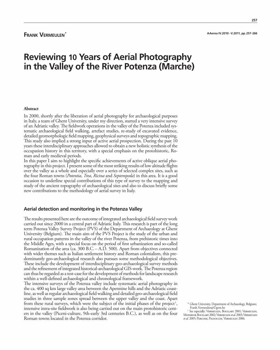
257
Frank vermeUlen *
Reviewing 10 Years of Aerial Photography in the Valley of the River Potenza (Marche)
AAerea IV.2010 - V.2011, pp. 257 - 266
* Ghent University, Department of Archaeology, Belgium; [email protected] See especially: Vermeulen, Boullart 2001; Vermeulen,
Monsieur, Boullart 2002; Vermeulen et al. 2003; Vermeulen et al. 2005; Percossi, Pignocchi, Vermeulen 2006.
Abstract
In 2000, shortly after the liberation of aerial photography for archaeological purposes in Italy, a team of Ghent University, under my direction, started a very intensive survey of an Adriatic valley. The fieldwork operations in the valley of the Potenza included sys-tematic archaeological field walking, artefact studies, re-study of excavated evidence, detailed geomorphologic field mapping, geophysical surveys and topographic mapping. This study also implied a strong input of active aerial prospection. During the past 10 years these interdisciplinary approaches allowed to obtain a new holistic synthesis of the occupation history in this territory, with a special emphasis on the protohistoric, Ro-man and early medieval periods.In this paper I aim to highlight the specific achievements of active oblique aerial pho-tography in this project. I present some of the most striking results of low altitude flights over the valley as a whole and especially over a series of selected complex sites, such as the four Roman towns (Potentia, Trea, Ricina and Septempeda) in this area. It is a good occasion to underline special contributions of this type of survey to the mapping and study of the ancient topography of archaeological sites and also to discuss briefly some new contributions to the methodology of aerial survey in Italy.
Aerial detection and monitoring in the Potenza Valley
The results presented here are the outcome of integrated archaeological field survey work carried out since 2000 in a central part of Adriatic Italy. This research is part of the long term Potenza Valley Survey Project (PVS) of the Department of Archaeology at Ghent University (Belgium). The main aim of the PVS Project is the study of the urban and rural occupation patterns in the valley of the river Potenza, from prehistoric times into the Middle Ages, with a special focus on the period of first urbanization and so-called Romanization of the area (ca. 300 B.C. – A.D. 500). Apart from objectives connected with wider themes such as Italian settlement history and Roman colonialism, this pre-dominantly geo-archaeological research also pursues some methodological objectives. These include the development of interdisciplinary geo-archaeological survey methods and the refinement of integrated historical-archaeological GIS-work. The Potenza region can thus be regarded as a test-case for the development of methods for landscape research within a well-defined archaeological and chronological framework.The intensive surveys of the Potenza valley include systematic aerial photography in the ca. 400 sq km large valley area between the Apennine hills and the Adriatic coast-line, as well as regular archaeological field walking and detailed geo-archaeological field studies in three sample zones spread between the upper valley and the coast. Apart from these rural surveys, which were the subject of the initial phases of the project 1, intensive intra-site fieldwork is also being carried out on the main protohistoric cent-ers in the valley (Piceni-culture, 9th-early 3rd centuries B.C.), as well as on the four Roman towns located in the Potenza corridor.

258 Frank vermeUlen
It is a major aim of the PVS-Project to supplement the static remote sensing material, e.g. existing vertical aerial photographs and satellite images, by new images from the air with a more direct archaeological impact. This new material is thereafter integrat-ed with information from other approaches, such as systematic field walking and intra-site geophysical work. Therefore, the program comprises a regular series of flights above the whole region to take aerial photographs from low altitude, with as major aims the detection, mapping, study and historical interpretation of the observed traces.Our flying operations 2 started in 2000, the exact year when aerial photography in Italy was liberalized from a formerly quite restrictive legislation. The flights are oper-ated from several airbases in the area, such as the international airport of Ancona and a few smaller airbases in or near the Potenza plain. The aircraft most often used is a 180 horse power 4-seater from the Aeroclub of Ancona, manned with a local experi-enced pilot and one or sometimes two photographers 3. In general our survey method is traditional. Most flights are executed in spring, summer or early fall, although oc-casional winter flights were done. The observation altitude is about 1000 feet, while many oblique photographs are made at some 300-500 feet, using standard reflex cameras (24 x 36 mm) for slides with normal films and since 2004 digital cameras. The flying pattern consists of continuous crossings of the valley and surrounding hills under different angles and of intensive circling over chosen targets. A crucial part of the strategy is that once a potential site or important feature is spotted there is a reg-ular follow up of that area during different seasons and in different weather condi-tions. Important also is the idea that rather small areas will be controlled several times a year, which makes it possible to organize a real follow up. We are convinced that this follow up of limited areas, such as the chosen transects for intensive fieldwork, is an important element in a full comprehension of the archaeological structures present in the soil. Indeed, one encounters many examples of truly remarkable ‘evolutions’ of archaeological sites due to totally different detection opportunities over different mo-ments, seasons or years. Three main approaches of reconnaissance over our study area must be distinguished. In a first phase (2000-2001) the whole Potenza valley was photographed, with regular flights in different seasons. Much of the data obtained in this way support the geo-morphologic and landscape studies in the area. Especially specific analyses, such as of erosion phenomena, the precise location of river terraces, ancient and modern water sources, fluvial movements through time and changes in land use, are much helped with the introduction of these detailed and flexible views from above. One of the typical geo-archaeological approaches much helped by such aerial photography is the movement of the river Potenza in the lower valley near its mouth, where a close rela-tion with the fast changing archaeological landscape was observed 4. This was espe-cially relevant for the location of roads, a river port, ancient land division, rural settle-ments, pottery production areas and bridges around the Roman colony of Potentia. The second approach of active aerial photography (mostly between 2001-2005) aimed at the detection of previously unknown archaeological sites in the crops, ploughed fields and other surface coverage spread all over the valley. Here results are obtained by very regular flights in the whole Potenza region and especially in the three transects chosen for intensive field walking campaigns, respectively in the upper-, middle- and lower valley. In all areas, whether only extensively or also intensively field-walked, the potential archaeological indications from the air were checked on the ground. Special attention was also given to the areas of known archaeological sites in the valley, where no intensive remote sensing had been done before. This systematic aerial reconnais-sance was followed up by systematic fieldwork, involving standardized registration, analysis, mapping and interpretation. All aerial photographs were stored in the Geo-graphic Information System of the project. Fundamentally a GIS links geometric data and non-spatial attribute data, allowing new ways of powerful data exploration, querying and analysis. Oblique aerial photographs have complex geometric distor-tions and cannot be mapped automatically in an easy way. Digital image processing and remote sensing and GIS-software offer new possibilities. Procedures for scanning, warping and geo-referencing the photographic images are being used to fully integrate the aerial data in the spatial analysis and interpretation of the sites 5.
2 The methodology applied here has been explained else-where: Vermeulen 2004 and Vermeulen, Verhoeven, Semey 2005.
3 Most photographs were taken by the author, while dur-ing the early years (2000-2002) UGent specialist Jacques Se-mey and in recent campaigns (2007-2008) Dr. Geert Verho-even assisted in this primary data capturing from the air.
4 This work is in collaboration with a team lead by colleague M. De Dapper (Department of Geography, Ghent University).
5 For the complex process of rectification/restitution and mapping of oblique views taken in a hilly landscape a combina-tion of special software and ground control is being applied. This work by collaborator Geert Verhoeven is done with the help of the software Airphoto 3.x, a program designed by Irwin Scollar and specifically developed to rectify archaeological images made with handheld uncalibrated cameras (Scollar 2002, p. 167).
1 - View on the protohistoric site of Montarice (Porto Recanati) with well distinguishable crop-marks of defences, buildings, pits and other settlement structures.
2 - View on the protohistoric hilltop site with earthwork enclosures of Monte Primo near Camerino.

259Reviewing 10 Years of Aerial Photography in the Valley of the River Potenza (Marche)
1
2

260 Frank vermeUlen
6 Special thanks go here to the teams of colleagues R. Goos-sens, A. De Wulf (Department of Geography, Ghent Univer-sity) and S. De Seranno (Katholicke Hogeschool Gent).
Since 2002 we also started a third approach to the archaeology of the region. Since then, intensive archaeological intra-site field survey work has been carried out on a series of large protohistoric (Picene) centres in the valley, as well as on the Roman towns situated in the Potenza corridor. From W to E these relatively small Roman cities are: Septempeda (San Severino Marche), Trea (Treia), Ricina (Villa Potenza) and Potentia (Porto Recanati). All of these sites – which are for most part totally abandoned since at least the early Middle Ages – have reasonable to excellent potential for non-destructive surface survey and because of the small scale of excavation work previous to our investigation of the area, much can be learned from an integrated survey ap-proach. Our surveys are designed to improve general understanding of the topography of proto-urban and urban settlement in this part of Italy and to deepen our knowl-edge of the processes of early (mostly Roman) urbanisation in the Marche. They are intended to integrate the results of non-destructive survey methods, such as oblique aerial photography and airphoto-interpretation, geophysical surveys, geomorpho-logical surveys, detailed topographic measurements and intensive field walking. The results of small-scale, previous or on-going, excavation work on these cities and arte-fact studies of survey materials and excavation finds are being integrated in this pic-ture, as they progressively become available. Within this site oriented approach the area of the selected large and complex sites was continuously monitored from the air, and especially intense flying during certain dry spring seasons (2003, 2009) has produced some remarkable images, locating and visualizing many aspects of the urban topography and of the suburban landscapes of the Roman valley cities and some of their protohistoric hilltop predecessors. Impor-tant efforts are being undertaken (by G. Verhoeven) to enhance, rectify and map the most relevant archaeological features of such complex sites. This is partly helped by specialized topographic fieldwork with a total station and GPS measurements and by new rectification approaches with creation of Digital Elevation Models 6. To enhance the possibilities for detailed and precise mapping of buried features also tests were done with a so-called Helikite. To deal with cloudy conditions (or other particular situations in which the shutter speed becomes too long for conventional aerial pho-tography) and allow us to obtain very detailed imagery of the large sites involved (in the visible, but also in the near-infrared and even ultraviolet range), a stable, easily maintainable and remotely controllable construction was created. This combination of a helium balloon with a kite is linked to a set of additional devices:– a Dyneema tether with a large breaking strain of 270 kg; – a dampened suspension for self-levelling and securing the camera-supporting cradle; – a sturdy cradle made from carbon, aluminium and three small servo motors; – a video live link (Pro X2) which instantaneously shows on a small TFT monitor the scene as seen by the D50; – a big game fishing reel and accompanying sea-fishing rod to manage the traction forces and allow the Helikite’s “pilot” to freely walk around; – a 35 Mhz remote control to wirelessly control the camera shutter and enable the steering of the camera by operating the servo motors on the cradle.It could be shown from the results obtained that this original instrument for Low Altitude Aerial Photography is capable of delivering imagery with a very small ground sampling distance, hence yielding so-called high spatial resolution imagery. Moreover, its low cost allows for a higher temporal resolution, as the platform can provide im-agery from a certain archaeological interesting area at short intervals.
A wide array of archaeologically significant results
Above we stressed that the most important use of active aerial survey by the PVS-team is directly linked to the detection of unknown archaeological features and the inten-sification of data concerning already ‘known’ sites. Very essential is also the direct confrontation with the systematic and intense fieldwork (artefact surveys, geophysical prospection, excavation,…) of our team in the areas concerned. After some 100 hours
3 - Recent view (2009) of a series of town structures on and around the forum of Roman Trea (Treia).


262 Frank vermeUlen
of archaeological flying over this region, resulting in a collection of more than 7000 oblique aerial images taken, we can now assess that conditions for aerial photography are quite favourable in the central area of Le Marche 7. Our work resulted not only in a spectacular increase of the number of new possible archaeological sites and ancient field structures (such as fragments of roads, ditches, pits,…), but also in a complete re-start of the study of some major known sites for which much new information could be assembled and mapped. Important is especially the follow up of the many new sites that had been found during our field walking campaigns of the September months of 2000 to 2003, and whose location, extent and appearance could now be investigated from another “point of view”.Restrictions of space in this paper allow us only a very quick overview of some of the most remarkable results concerning the two periods under investigation: 1. Final Bronze and Iron Age, 2. Roman period.
Final Bronze and Iron Age
As only few settlement structures have been discovered till now, most knowledge about the Final Bronze and Iron Age cultures in Marche derives from funeral sites. The PVS-surveys procured some insight into the protohistoric settlement system of the area before the slow Romanization of the 3rd and 2nd century BC 8. They point at a clear distinction between two main types of settlement: dominant and large hilltop sites and smaller rural valley sites. A series of hilltop sites dispersed along the valley, which in the course of the Iron Age is more and more dominated by elite groups within protohistoric society, long re-mained crucial for the control over the Potenza corridor 9. Although the location of some of these sites was known before the start of our project, fieldwork and especial-ly aerial photography starts to highlight their crucial appearance and role. Aerial pho-tography was very helpful in the detection and finer mapping of some of these. We mention for instance the hilltop site on Monte Primo (fig. 2), near Camerino, where our flights in all seasons could help map an intricate system of enclosures and ap-proaches, visible as shadow marks in the grassland vegetation. On another site, lying on the high plateau of Montarice (fig. 1), overlooking the river mouth at present-day Porto Recanati, our aerial photography surveys combined with artefact surveys, re-vealed the existence of an equally important Late Bronze and Iron Age centre, with diachronically different enclosures and remains of houses clearly distinguishable in the crop marks of grain. Near some of these elite centres, such as Mont Pitino and Monte Franco (Treia) in the middle valley, we spotted also several unknown elite burials, distinguishable as interlaced circles in the crops, the result of groupings of former tumuli with ditches.The flights all over the valley, but especially in the 3 transects of detailed artefact sur-veys, also helped to visualize the smaller late Bronze and Iron Age valley-settlements. Most of the circa 25 protohistoric settlements discovered during fieldwork were some-how also distinguishable from the air, with settlement features (ditches, pits, pottery scatters, …) seen as crop marks or soil marks.
Roman period
The much more visible human landscape of the Roman period gave us the opportu-nity to discover and study many more traces from the air, contributing to the realiza-tion of real landscape archaeology in this area. Our systematic field surveys in the transects, resulted in the discovery of more than 100 formerly unknown Roman vil-las and farms, quite evenly distributed over the three survey transects 10. Systematic flying over them resulted in the observation of anomalies in almost 80% of the fields
7 To explore this potential further a series of flights were also organised above the more southern Marche valleys of the rivers Tenna and Aso, in close collaboration with a field survey team of the University of Pisa directed by Prof. M. Pasqui-nucci. Although results were also good here, particularly in the Tenna area, it is clear that the archaeological harvest in the Potenza valley is more impressive.
8 Vermeulen, Verhoeven 2004; Boullart 2003; Per-cossi, Pignocchi, Vermeulen 2006.
9 Bonomi Ponzi 1992.10 Vermeulen, Verdonck 2004; Percossi, Pignocchi,
Vermeulen 2006.
263Reviewing 10 Years of Aerial Photography in the Valley of the River Potenza (Marche)
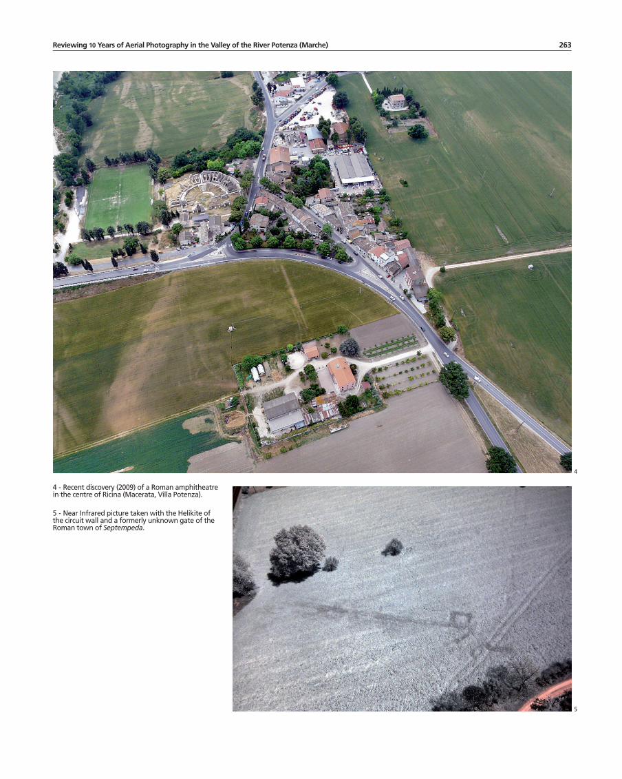
4 - Recent discovery (2009) of a Roman amphitheatre in the centre of Ricina (Macerata, Villa Potenza).
5 - Near Infrared picture taken with the helikite of the circuit wall and a formerly unknown gate of the Roman town of Septempeda.
4
5

264 Frank vermeUlen
11 Alfieri 1970; Moscatelli, Vettorazzi 1988.12 For this work the PVS team was well assisted by the Ar-
chaeological Prospection Services of Southampton University and by the University of Ljubljana.
where these sites are located. As we systematically photographed the newly found sites in late September most often discolorations in the ploughed soil can be seen, prob-ably the result of a combination of ploughed up occupation layers, zones with lo-cally more organic substance in the upper layers and humidity traces caused by dif-ferential drying of the soil in some archaeological zones. In a few examples, at present on less than 10% of these sites, our aerial photography spotted clear crop marks of building structures such as houses and secondary structures. However, results show that not all isolated Roman sites in the countryside are rural settlements. Very remark-able were the discovery of such Roman sites as a rural temple at Villa Potenza, remains of a bridge at Potenza Picena, several sites of amphora production near the coast and parts of a vicus at Passo di Treia. The latter was not only confirmed by fieldwalking, but recently digs by the Soprintendenza per i Beni Archeologici, showed its configu-ration and prominent Imperial date.Some of the very regularly found non-site features with a linear trace of a different ori-entation than the current field pattern can also be placed in the Roman period. This is obviously the case of several linear traces, with the width of a road, discovered in differ-ent parts of the valley floor, some of which coincide with the presumed location of the main Roman road through the Potenza corridor, namely a diverticulum of the Via Flamin-ia from Nocera to Ancona, partly branching off to the coastal town of Potentia. Other linear traces, sometimes clearly connected with the Roman roads, could be part of the presumed normative field systems (centuriatio) that were organised by the Romans in different parts of the valley floor, such as near the ancient cities of Potentia and Trea 11.But it is especially our contribution via aerial detection to the study of the topography of the Roman cities in the valley that should be underlined here. We are very fortu-nate that these town sites are mostly free of modern occupation and that they are still taken in by normal agricultural practice. All of them, namely Septempeda, Trea, Rici-na and Potentia, delivered quite spectacular results which allow us (in combination with the geophysics done since 2004 on the sites of Trea and Potentia 12). It is impos-sible to enumerate here the multitude of architectural structures brought to light in and around these cities. A synopsis of the major discoveries, which have now almost all been mapped carefully within the GIS system, would comprise the following (mainly Early Imperial) structures:– Septempeda: several new elements (gate, towers,…) of the already partly known city wall (fig. 5), the whole street network (which was quasi totally unknown), many domus and other houses in the intra-mural part and a major sanctuary extra-muros.
6 - Crop marks and grass marks of the main Roman road entering Potentia from W.
7 - Simplified map of the main features of the town of Potentia, partly according to evidence from recent aerial photography.
6 7

265Reviewing 10 Years of Aerial Photography in the Valley of the River Potenza (Marche)
– Trea: parts of the circuit wall (with towers and gates) whose trace can now be fully mapped, the main pattern of city streets, the forum and most of its surrounding pub-lic buildings (several temples, tabernae, the basilica, a macellum) and a whole series of town houses and workshops (fig. 3). – Ricina: a large part of the formerly unsuspected wall circuit, an amphitheatre (fig. 4), a main temple complex, several domus and other private houses and probably the town’s aqueduct.– Potentia: the full regular town grid (size 15 by 10 actus) with complete wall circuit (fig. 7), the three gates, all streets and insulae (some of which were know via earlier re-search), the forum with temple, other public buildings (e.g. a small theatre or odeum) and shops, several elements of private housing and finally three roads leaving the colonial coastal town (fig. 6) flanked by photographically well attested funerary monuments 13.
Conclusion
It is particularly clear from the research in the Potenza valley that the remote sensing information, especially derived from intensive low altitude aerial photography survey, is crucial in the process of revealing and studying the archaeology of the Marche re-gion. Especially when this type of archaeological detection can be continued over a wide span of several years, making good use of the diversity of seasons and specifi-cally adapted periods of “archaeological flying”, it is even essential in the successful study of suitable periods such as Protohistory and the Roman era. Moreover, when such research can be undertaken in close integration with intensive artifact surveys and other field approaches (geophysics, geomorphological observations, small scale excavation,…) and when the full potential of image processing and data capture (in-cluding NIR and UV photography) is included, it can revolutionize our comprehen-sion of the occupation history of a well delineated region.
Bibliography Alfieri 1970: N. Alfieri, La centuriazione romana
nelle basse valli del Potenza e del Chienti. Ricerche sull’età romana e preromana nel Maceratese, in Atti IV Convegno del Centro di Studi Storici Maceratesi, Macerata 1970, pp. 215-225.
Bonomi Ponzi 1992: L. Bonomi Ponzi, Occupazio-ne del territorio e modelli insediativi nel territorio Plestino e Camerte in età protostorica, in La civiltà picena, Ripatransone 1992, pp. 204-241.
Boullart 2003: C. Boullart, Piceni settlements: un-traceable or neglected?, in Picus, XXIII, 2003, pp. 155-188.
Moscatelli, Vettorazzi 1988: U. Moscatelli, L. Vettorazzi, Aspetti delle divisioni agrarie romane nelle Marche, in Le Marche. Archeologia, Storia, Territorio, Arcevia 1988, pp. 7-84.
Percossi, Pignocchi, Vermeulen 2006: E. Percossi, G. Pignocchi, F. Vermeulen (a cura di), I siti ar-cheologici della Vallata del Potenza, Ancona 2006.
Scollar 2002: I. Scollar, Making Things Look Verti-cal, in R. Bewley, W. Raczkowski (eds.), Aerial Ar-chaeology. Developing Future Practice, NATO Science Series. Series I: Life and Behavioural Sciences, 337, Amsterdam 2002, pp. 166-172.
Vermeulen 2004: F. Vermeulen, Fotografia aerea fina-lizzata nelle Marche Centrali: Un progetto integrato, in A Aerea I, 2004, pp. 91-118.
Vermeulen 2008: F. Vermeulen, Functional zoning and changes in the use of space in the Roman town of Poten-tia. An integrated survey approach, in H. Vanhaver-beke, J. Poblome, F. Vermeulen, M. Waelkens, R. Brulet (eds.), Thinking about space. The potential of surface survey and contextual analysis in the defini-tion of space in Roman times. Studies in Eastern Med-iterranean Archaeology, VIII, Turnhout 2008, pp. 233-249.
Vermeulen, Boullart 2001: F. Vermeulen, C. Boul-lart, The Potenza Valley Survey: preliminary report on field campaign 2000, in BABesch, 76, 2001, pp.
1-18.Vermeulen et al. 2003: F. Vermeulen, M. De Dapper,
Ph. Crombé, B.-M. De Vlieger, P. Monsieur, C. Boullart, T. Goethals, H. Verreyke, G. Ver-hoeven, I. Devriendt, G. Vanheddeghem, J. Semey, The Potenza Valley Survey: preliminary report on field campaign 2002, in BABesch, 78, 2003, pp.
71-106.Vermeulen, Hay, Verhoeven 2006: F. Vermeulen,
S. Hay, G. Verhoeven, Potentia: an Integrated
13 The most recent overviews about on-going work in Po-tentia are: Vermeulen 2008; Vermeulen, Hay, Verhoeven 2006.

266 Frank vermeUlen
Survey of a Roman Colony on the Adriatic Coast, in PBSR, 74, 2006, pp. 203-236.
Vermeulen, Monsieur, Boullart 2002: F. Vermeu-len, P. Monsieur, C. Boullart, The Potenza Valley Survey: preliminary report on field campaign 2001, in BABesch, 77, 2002, pp. 49-71.
Vermeulen et al. 2005: F. Vermeulen, M. Monsieur, C. Boullart, H. Verreyke, G. Verhoeven, M. De Dapper, T. Goethals, R. Goossens, B.- M. De Vliegher, The Potenza Valley Survey: Prelimi-nary Report on Field Campaign 2003, in BABesch, 80, 2005, pp. 33-64.
Vermeulen, Verdonck 2004: F. Vermeulen, L. Verdon-ck, A contribution to the study of Roman rural settlement in Marche, in Picus, XXIV, 2004, pp. 161-229.
Vermeulen, Verhoeven 2004: F. Vermeulen, G. Verhoeven, The contribution of aerial photogra-phy and field survey to the study of urbanization in the Potenza valley (Picenum), in JRA, 17, 2004, pp. 57-82.
Vermeulen, Verhoeven 2006: F. Vermeulen, G. Verhoeven, An Integrated Survey of Roman Ur-banization at Potentia, Central Italy, in JFieldA, 31, 2006, pp. 395-410.
Vermeulen, Verhoeven, Semey 2005: F. Vermeulen, G. Verhoeven, J. Semey, The integration of Aerial Photography and GIS in the Potenza Valley Survey, in J. Bourgeois, M. Meganck (eds.), AP & A 2003. A Century of Information, Gent 2005, pp.
371-382.