Embed Size (px)
Citation preview
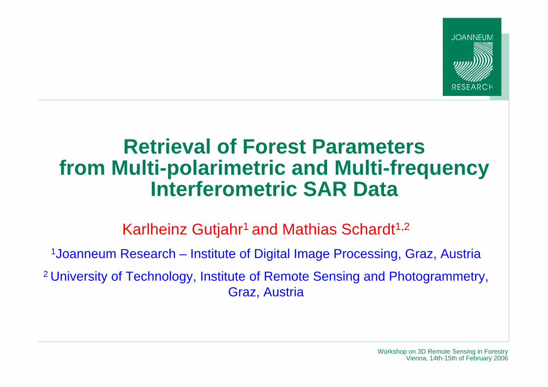
Workshop on 3D Remote Sensing in ForestryVienna, 14th-15th of February 2006
Retrieval of Forest Parameters from Multi-polarimetric and Multi-frequency
Interferometric SAR Data
Karlheinz Gutjahr1 and Mathias Schardt1,2
1Joanneum Research – Institute of Digital Image Processing, Graz, Austria2 University of Technology, Institute of Remote Sensing and Photogrammetry,
Graz, Austria

Workshop on 3D Remote Sensing in ForestryVienna, 14th-15th of February 2006
© Institute of Digital Image ProcessingJoanneum Research, Page - 2
Test site “Kobernausser Wald”Forest test site:Kobernausser Wald
Geographic Coordinates:UL: 13°19’E / 48°04’NLR: 13°25’E / 48°00’N
Area Size: 3km x 9km

Workshop on 3D Remote Sensing in ForestryVienna, 14th-15th of February 2006
© Institute of Digital Image ProcessingJoanneum Research, Page - 3
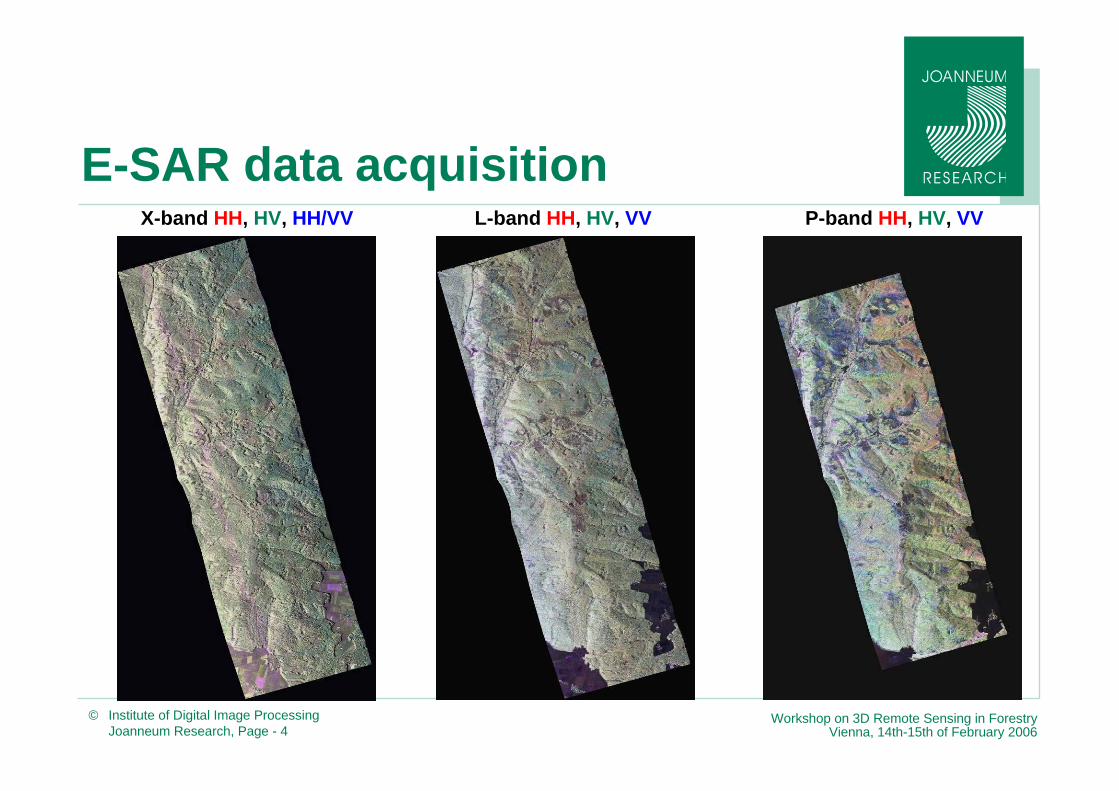
E-SAR data acquisition— Flight campaign on 11.05.2004
— Two corner reflectors installed
E-SAR data acquired over Kobernausser Wald test site
Dual
Dual
Single
Pass
10 mSLC & IntensityHH/HV/VH/VVL-band
20 mSLC & IntensityHH/HV/VH/VVP-band
0.5 mSLC & IntensityHH/VVX-band
BaselineData TypePolarisationFrequency
Workshop on 3D Remote Sensing in ForestryVienna, 14th-15th of February 2006
© Institute of Digital Image ProcessingJoanneum Research, Page - 4
E-SAR data acquisitionP-band HH, HV, VVL-band HH, HV, VVX-band HH, HV, HH/VV
Workshop on 3D Remote Sensing in ForestryVienna, 14th-15th of February 2006
© Institute of Digital Image ProcessingJoanneum Research, Page - 5
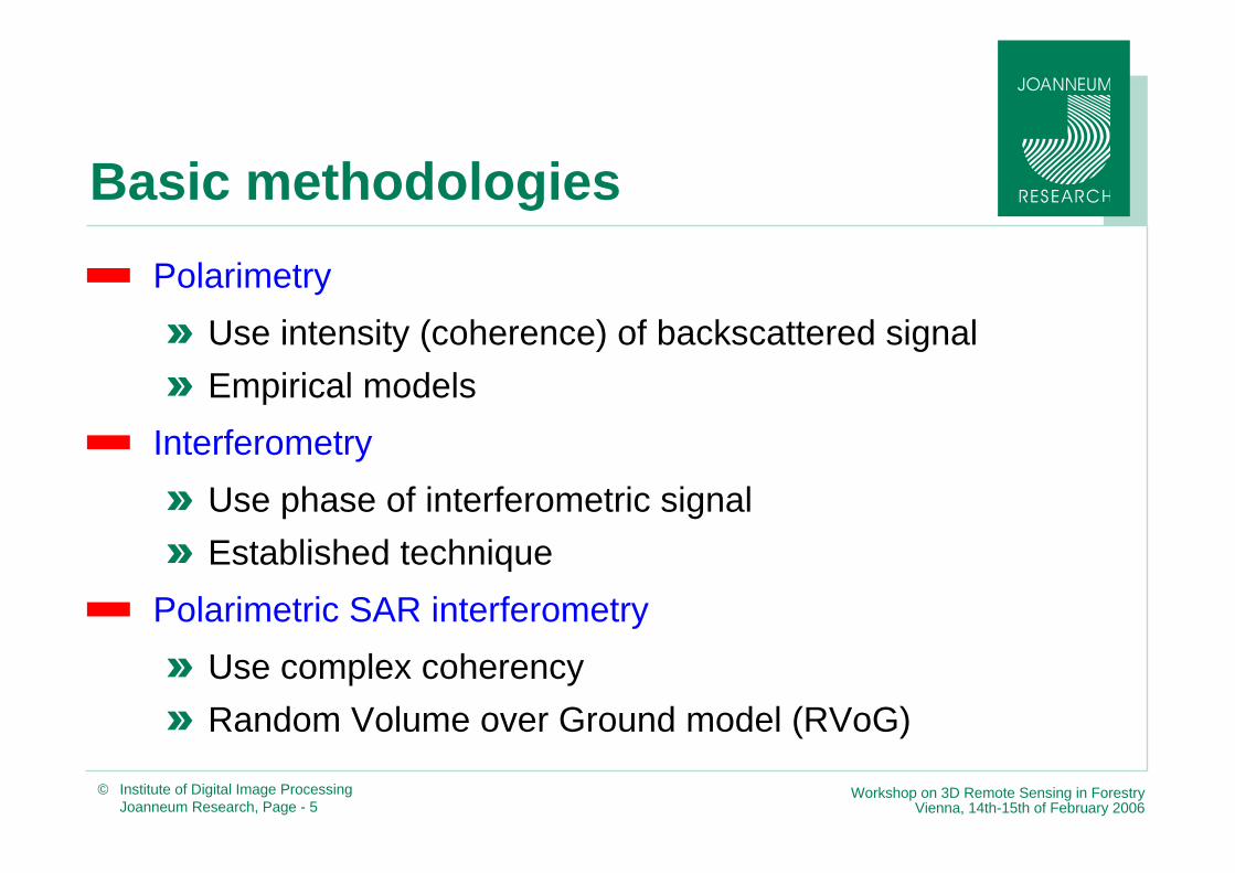
Basic methodologies— Polarimetry
» Use intensity (coherence) of backscattered signal» Empirical models
— Interferometry» Use phase of interferometric signal» Established technique
— Polarimetric SAR interferometry» Use complex coherency» Random Volume over Ground model (RVoG)

Workshop on 3D Remote Sensing in ForestryVienna, 14th-15th of February 2006
© Institute of Digital Image ProcessingJoanneum Research, Page - 7
SAR interferometry— Approximation
( )sinr Bδ ζ θ= ⋅ −
( )( ) 0cos cosz h hhr r
θ θ−= = −
( ) ( )( )( )
( )
0
0
0
22 3
0
sin
cossin
cos...
2 sin
r h B
Bh
r
Bh
r
δ ζ θ
ζ θθ
ζθ
= ⋅ − +
⋅ −⋅ +
⋅
⋅⋅ +
( ) ( ) ( )( )
00
0
cos4 sin ...sinabs
Bh hr
ζ θπφ ζ θλ θ
⎡ ⎤−= ⋅ − + ⋅ +⎢ ⎥⋅⎣ ⎦
Workshop on 3D Remote Sensing in ForestryVienna, 14th-15th of February 2006
© Institute of Digital Image ProcessingJoanneum Research, Page - 8
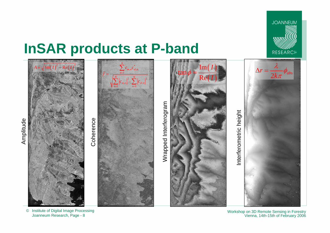
InSAR products at P-band
Wra
pped
Inte
rfero
gram
Inte
rfero
met
riche
ight
Am
plitu
de
( ) ( )2 2Im ReA I I= +
Coh
eren
ce
*, ,
1
2 2, ,
1 1
ˆ
N
m n sl nn
N N
m n sl nn n
c c
c cγ =
= =
=
⋅
∑
∑ ∑
( )( )
Imtan
ReII
φ = 2 absrkλ φπ
Δ =

Workshop on 3D Remote Sensing in ForestryVienna, 14th-15th of February 2006
© Institute of Digital Image ProcessingJoanneum Research, Page - 9
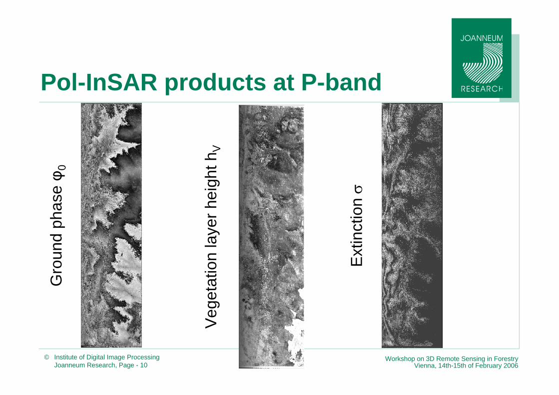
Polarimetric SAR Interferometry
( )
[ ]0
11
21
32
3
expVh
Mmmm
ϕγ
σγγ
−
⎡ ⎤⎢ ⎥ℑ⎢ ⎥ ⎡ ⎤⎢ ⎥ ⎢ ⎥=⎢ ⎥ ⎢ ⎥⎢ ⎥ ⎢ ⎥⎣ ⎦⎢ ⎥⎢ ⎥⎢ ⎥⎣ ⎦
Random Volume over Ground model*
*K. P. Papathanassiou and S. R. Cloude: Single-baseline polarimetric SAR interferometry.In IEEE Transactions Geoscience Remote Sensing, Vol. 39, No. 11, 2352-2363, 2001.
hV = tree heightϕ0 = ground topographyσ = mean volume extinctionm = ground to volume scattering amplitudeγ = complex interferometric coherence[M] = scattering model operator
Workshop on 3D Remote Sensing in ForestryVienna, 14th-15th of February 2006
© Institute of Digital Image ProcessingJoanneum Research, Page - 10
Pol-InSAR products at P-bandG
roun
dph
aseφ 0
Ext
inct
ionσ
Veg
etat
ion
laye
rhei
ghth
V

Workshop on 3D Remote Sensing in ForestryVienna, 14th-15th of February 2006
© Institute of Digital Image ProcessingJoanneum Research, Page - 11
Laser scanner reference DHMsN
orth
ern
part
Sou
ther
n pa
rt
Workshop on 3D Remote Sensing in ForestryVienna, 14th-15th of February 2006
© Institute of Digital Image ProcessingJoanneum Research, Page - 12
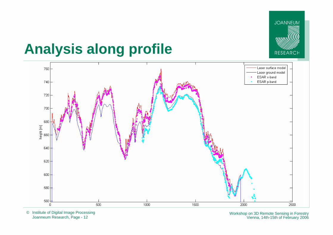
Analysis along profile

Workshop on 3D Remote Sensing in ForestryVienna, 14th-15th of February 2006
© Institute of Digital Image ProcessingJoanneum Research, Page - 13
InSAR canopy height model (CHM)

Workshop on 3D Remote Sensing in ForestryVienna, 14th-15th of February 2006
© Institute of Digital Image ProcessingJoanneum Research, Page - 14
Pol-InSAR canopy height model

Workshop on 3D Remote Sensing in ForestryVienna, 14th-15th of February 2006
© Institute of Digital Image ProcessingJoanneum Research, Page - 15
Combined canopy height model

Workshop on 3D Remote Sensing in ForestryVienna, 14th-15th of February 2006
© Institute of Digital Image ProcessingJoanneum Research, Page - 16
Correlation
Interferometry Combination
Correlation Coefficient: 0.64 Correlation Coefficient: 0.81
Workshop on 3D Remote Sensing in ForestryVienna, 14th-15th of February 2006
© Institute of Digital Image ProcessingJoanneum Research, Page - 17
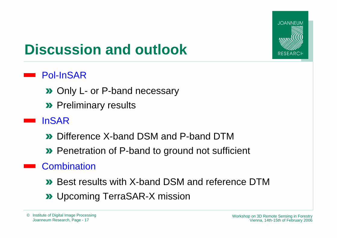
Discussion and outlook— Pol-InSAR
» Only L- or P-band necessary» Preliminary results
— InSAR» Difference X-band DSM and P-band DTM» Penetration of P-band to ground not sufficient
— Combination» Best results with X-band DSM and reference DTM» Upcoming TerraSAR-X mission