Embed Size (px)
Citation preview
Results from a GPS Timing Criticality Assessment
European Navigation Conference, GNSS 2008Session 2b - Timing
James Carroll, DOT/RITA Volpe Center
April 2008

2
Introduction
Timing Criticality Assessment Goals:• Analyze the consequences of GPS timing services
outages or disruptions• Update the Department of Homeland Security/
Homeland Security Institute timing criticality study• Determine the benefits and relative costs of alternate
systems that mitigate the impact of a GPS outage or disruption on the national Time and Frequency (T/F) infrastructure critical to the safety, security or economic well-being of the United States
• Get information from T/F Subject Matter Experts• Focus of this briefing: civilian T/F applications
NOTE: The material in this briefing reflects the opinion ofThe material in this briefing reflects the opinion ofthe author only, and does not reflect U.S. Government policythe author only, and does not reflect U.S. Government policy

3
Major Conclusions
• The T/F application sectors are Electric Power and Telecommunications play a vital role and are highly reliant on GPS– Electric Power and Telecommunications also have large
influence on the performance of the rest of the national infrastructure
• GPS is increasingly used for highly accurate timing services
• Because GPS (& GNSS) are vulnerable to radiofrequency interference, using backup T/F sources is crucial in mitigating GPS disruptions during critical applications
• Many important applications (e.g., many financial transactions) may not require accurate timing now, but evolving trends support a growing need for more accurate time - for efficiency, safety, and security
4
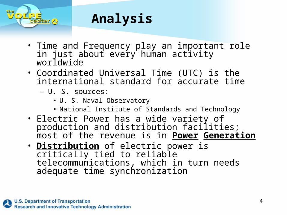
Analysis
• Time and Frequency play an important role in just about every human activity worldwide
• Coordinated Universal Time (UTC) is the international standard for accurate time– U. S. sources:
• U. S. Naval Observatory• National Institute of Standards and Technology
• Electric Power has a wide variety of production and distribution facilities; most of the revenue is in Power Generation
• Distribution of electric power is critically tied to reliable telecommunications, which in turn needs adequate time synchronization

5
LORAN-C
WWV / WWVB
SATCOM
INTERNATIONALTIMING
CENTERS
UTC (XYZ)NUTC (USNO)
UTC (NIST)
GPS
SBAS
SBAS INTERNET - NTP
NAVIGATION
POWER SYSTEMS
TELECOMMUNICATIONS
SPACE - GEOPHYSICS
CELLULAR / WIRELESS WIRED/CABLE/FIBER
COMSAT
TWSTFT
DISSEMINATION SYSTEMS
Ron Beard, NRL, 2003 CGSIC
Timing/Frequency Overview
LORAN-C/eLORAN

6
Timing User Range
0.1 ns 1 ns 10 ns 100 ns 1 µs 10 µs 100 µs 1 ms 10 ms 100 ms 1 s
PTTI/R&D- NIF
Scientific/Experimental
High Precision Military
Advanced Comms
Power Systems- Fault Location- Phasor Meas- Data Sharing
CDMA2000- Base Stations
Low Precision Military
Astronomy
Financial Transactions
National Timing Labs
Wide Area Data Logging- Seismic monitoring- Nuclear Blast Detection
Digital Time Servers- NTP, etc
Authentication- Internet login
Timing user survey is not intended to be a complete representation of all users. Requirements have been generalized and averaged over user groups
Timing AccuracyCapabilities: GPS eLORAN WWVB
Tom Celano, 2003
7
UTC Time Synchronization
• Systems that meet Stratum 1 Primary Reference Source (“clock”) requirements:– GPS– Other GNSS (Galileo, GLONASS, Compass, etc.)– WAAS– Networks/Atomic Clocks (e.g., CDMA, GSM)– Loran-C (legacy) and Enhanced Loran (eLoran)– NIST Broadcast Radio (WWVB)
• The emphasis in this briefing is on civilian applications

8
GPS: Enabling Technology
o Electric Powero Telecommunications/
Communications/Radio Broadcast
o Transportation/maritime/aviation/land
o Emergency Response o Internet/Cyber
o Defenseo Bankingo Water Supplyo Agriculture o Chemical
Industry/Hazmato Postal/shippingo Weather
• Provides Stratum 1 capability globally Backup clocks will mitigate loss of the GPS signal
• Supports Critical T/F Application Areas, e.g.,
= Focus Area
9
Electric Power Distribution
• There are four major power grids (“Interconnections”) in North America: Texas, Quebec, Western U.S., and Eastern U.S.– Also six Independent System Operators
• Operating revenues of the share-holder owned electric companies are $325.6B per year (2004 data)
• The total annual cost of “large” blackouts only is estimated at $100B per year
• The industry is reluctant to utilize new technology• Those responsible for grid architecture and operation
should assess risks to reliable power distribution

10
GPS Role in Electric Power
• Present GPS T/F uses include asset management & performance analysis; the grid does not at this time depend on GPS to function – could change in future– Electric power timing requirements are at, or are approaching,
1 μsec absolute accuracy• Energy management systems monitor consumption
generation and the electric power paths. The newer systems use GPS for time stamps
• In the event of loss of a usable GPS signal, the quality of data on system operation deteriorates; the system does not fail, but very often revenue is needlessly lost– Actual diagnosis of the August 2003 blackout took a year to
complete – and still had information gaps– A more effective T/F system could have taken about two
weeks or less
11
Short Term Prognosis for Power
• U.S. & similar grids are increasingly burdened by growing demand; serious power failures occur almost annually; the next major failure is a matter of “when,” not “if”– U.S. grid monitoring equipment is decades old– There are concerns about grid robustness in near term future
• Deregulation has not worked as well as planned– Restructuring has obscured responsibility for a given region– Power plants have more revenue focus than the distribution
grid• A way out: “smart grids” – real time control, self-
healing, and superconductivity– Superconductivity cables have 10% diameter, do not need
bulky circuit breakers– Hydro Quebec is very active in using GPS for grid stability
12
Telecommunications
• The telecommunications industry considers GPS as the primary precise time reference source, and “the network” as secondary
• GNSS and Loran are somewhere in between GPS and network timing, in terms of performance
• “Signals of Interest” (to selected commercial entities)– GPS, WAAS, EGNOS, Loran
• Mobile phones can operate globally– Protocols for this are Global System Mobile (GSM)
or Code Division Multiple Access (CDMA)
13
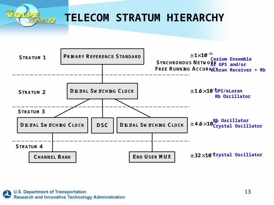
TELECOM STRATUM HIERARCHY
PRIMARY REFERENCE STANDARD
DIGITAL SWITCHING CLOCK
DSC
CHANNEL BANK END USER MUX
STRATUM 1
STRATUM 2
STRATUM 3
STRATUM 4
SYNCHRONOUS NETWORK
FREE RUNNING ACCURACY
DIGITAL SWITCHING CLOCKDIGITAL SWITCHING CLOCK
111 10
81.6 10
64.6 10
632 10
Cesium Ensembleor GPS and/oreLoran Receiver + Rb
GPS/eLoranRb Oscillator
Rb OscillatorCrystal Oscillator
Crystal Oscillator
14
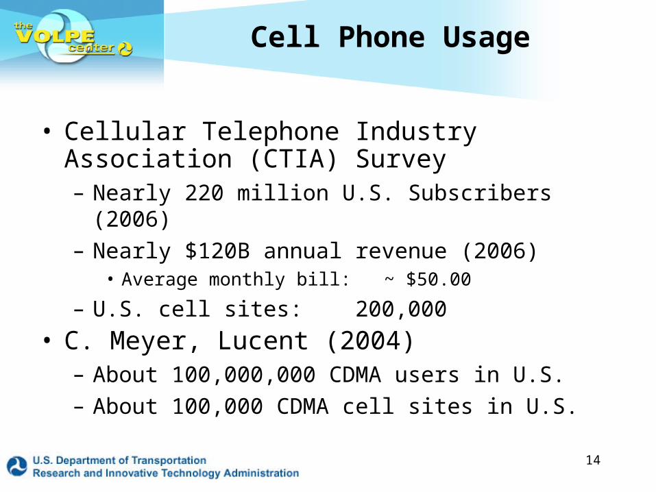
Cell Phone Usage
• Cellular Telephone Industry Association (CTIA) Survey– Nearly 220 million U.S. Subscribers (2006)– Nearly $120B annual revenue (2006)
• Average monthly bill: ~ $50.00
– U.S. cell sites: 200,000
• C. Meyer, Lucent (2004)– About 100,000,000 CDMA users in U.S.– About 100,000 CDMA cell sites in U.S.
15
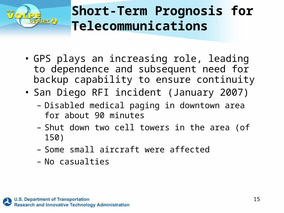
Short-Term Prognosis for Telecommunications
• GPS plays an increasing role, leading to dependence and subsequent need for backup capability to ensure continuity
• San Diego RFI incident (January 2007)– Disabled medical paging in downtown area for
about 90 minutes– Shut down two cell towers in the area (of 150)– Some small aircraft were affected– No casualties
16
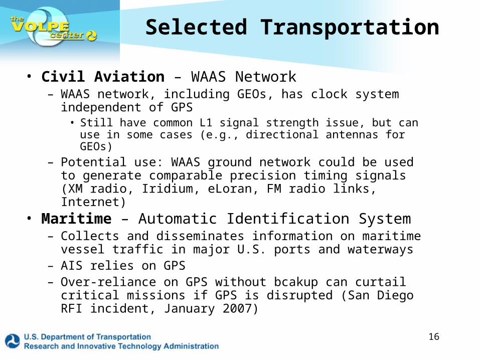
Selected Transportation
• Civil Aviation – WAAS Network– WAAS network, including GEOs, has clock system
independent of GPS• Still have common L1 signal strength issue, but can use in some
cases (e.g., directional antennas for GEOs)
– Potential use: WAAS ground network could be used to generate comparable precision timing signals (XM radio, Iridium, eLoran, FM radio links, Internet)
• Maritime – Automatic Identification System– Collects and disseminates information on maritime vessel
traffic in major U.S. ports and waterways– AIS relies on GPS– Over-reliance on GPS without bcakup can curtail critical
missions if GPS is disrupted (San Diego RFI incident, January 2007)

17
Summary of Activities
• Several Subject Matter Experts (SMEs) throughout the T/F area have contributed
• Analyzed the electric power distribution, wireless telecom, and some transportation application areas– Not all areas require precision T/F (e.g.,
banking/finance requires msec accuracy)
• DHS and DoT are supporting the study• Project report is under review• Volpe has a prototype eLoran Research
Receiver and is testing its performance

19
Project Background
• An updated U.S. Space-Based PNT Policy was signed by the President in December 2004
• The 2004 Policy tasked DHS to develop an Interference Detection and Mitigation (IDM) plan
• A PNT Working Group, tasked by the IDM plan, was set up by DHS to implement the plan– Elements for plan implementation include
• Timing Criticality update study (HSI, January 30, 2006)• Update of Volpe GPS Vulnerability study (2001)
20
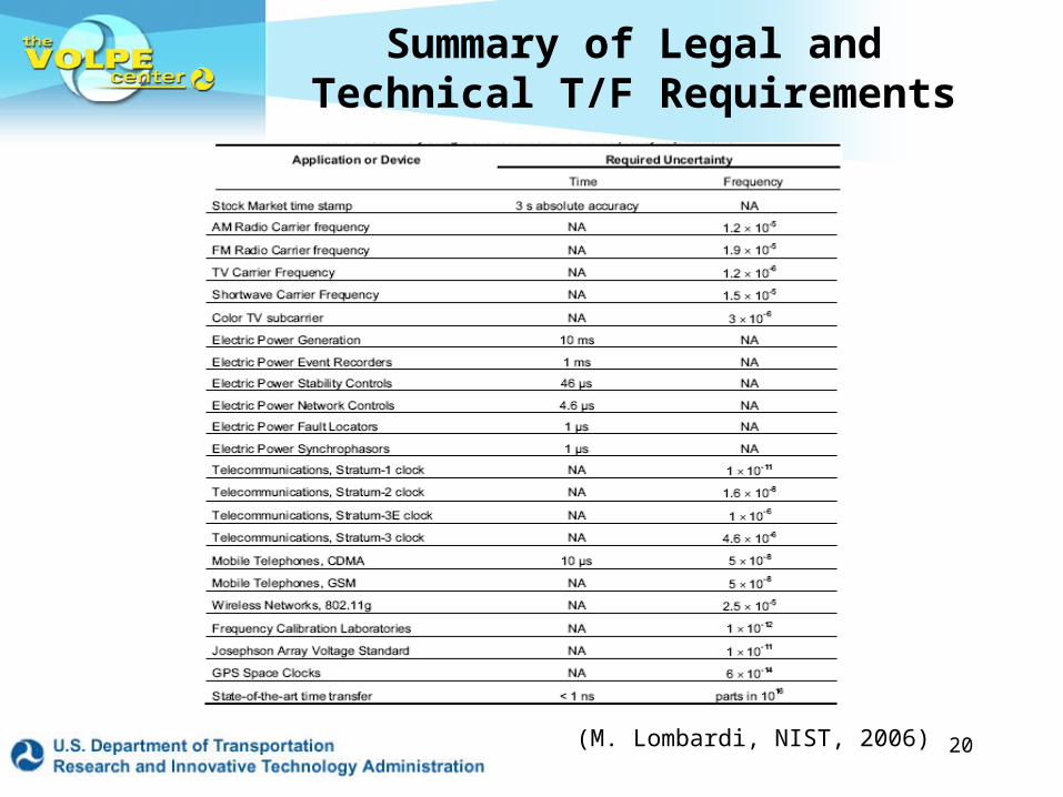
Summary of Legal and Technical T/F Requirements
(M. Lombardi, NIST, 2006)
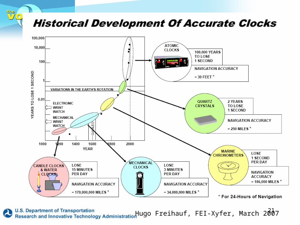
21Hugo Freihauf, FEI-Xyfer, March 2007

22
CTIA: 2006 Industry Survey, U.S.

23
• A GPS signal disruption in 2006 did not disable system operation in the affected area but did disrupt billing. It became very difficult to determine which grid sector was lending or borrowing power during this disruption
• Phasor synchronization devices are regularly being installed. Each device will be time-stamped using GPS. This evolving trend may leave system operators unsure of how to respond if GPS is disrupted
• Grid stability analysis researchers at Cornell, Carnegie-Mellon and VA Tech say GPS “could” be a real help– They recommend GPS-based real-time network monitoring and
time-stamping of phasors; sub-millisec precision is needed– Industry approach is to “go slowly” with high tech; DOE & North
Am. Elec. Reliability Corp. (NERC) want an automatic network for real-time monitor and control of grid (P. Overholt, DOE)
GPS Role in Electric Power (2)
24
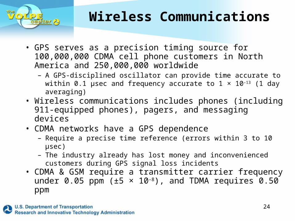
Wireless Communications
• GPS serves as a precision timing source for 100,000,000 CDMA cell phone customers in North America and 250,000,000 worldwide– A GPS-disciplined oscillator can provide time accurate to within
0.1 µsec and frequency accurate to 1 × 10-13 (1 day averaging)• Wireless communications includes phones (including
911-equipped phones), pagers, and messaging devices • CDMA networks have a GPS dependence
– Require a precise time reference (errors within 3 to 10 µsec)– The industry already has lost money and inconvenienced
customers during GPS signal loss incidents• CDMA & GSM require a transmitter carrier frequency
under 0.05 ppm (±5 × 10⁻⁸), and TDMA requires 0.50 ppm
25
Transportation – Aviation (2)
• Automatic Dependent Surveillance – Broadcast: Multilateration– Two types of multilateration: Active and Passive
• Active uses existing transponder equipment; can, but not required to, use ADS-B data links
• Passive must equip with ADS-B data links
– In either case, Loran is the recommended GPS data link backup T/F source for MLAT, because of cost, performance and availability in the U.S. National Airspace System
• Note: multilateration is not under active consideration for the ADS-B backup system at this time