Embed Size (px)
Citation preview

Resource Consent Application WGN130103: Hydrogeology Technical Review
Dr Douglas Mzila Senior Environmental Scientist – Groundwater Environmental Science Department
May 2013
www.gw.govt.nz [email protected]


Contents
Summary of key points 1
A Introduction 2
B Scope of this report 2
C Summary of the proposal 3 Proposed adaptive management for large drawdowns below streams and
wetlands: 4 Proposed adaptive management for large drawdowns in deep aquifers 4 Proposed adaptive management for control of saltwater Intrusion 4
D Description of the environment 4 Conceptual Hydrogeology of Waikanae 5 Water Balances 6 Shallow and deep groundwater level responses 6 Groundwater/surface water interaction 8 Saltwater Intrusion 12
D Adequacy and completeness of information 14 General Assessment 14 Construction and calibration of the applicant’s model 15
E Assessment of environmental effects (AEE) 17 Cumulative effects on the environment 17 Effects on Wetlands and Small Streams 17 Saltwater intrusion potential 18
F Comments on submissions 21 Potential effects on wetlands and surface water 21 Potential effects on other groundwater users 21 Potential for saltwater intrusion 22 Potential risk from aquifer injection 22
G Draft monitoring plan, mitigation and proposed consent conditions 22
Draft monitoring plan 22 Mitigation against excessive groundwater level decline in aquifers 22 Saltwater Intrusion 24
H Recommendations for conditions of consent 25
I Recommendations 26
J References 26


WGN_DOCS-#1211068-V3 PAGE 1 OF 27
Summary of key points
1. The applicant has undertaken a significant amount of work in attempting to understand the potential effects of the River Recharge with Groundwater (RRwGW) proposal. The overall strategy and quality of the investigations is considered reasonable. Further drilling and investigations were of high standard but surface water investigations were limited to the Waikanae River. There remains some uncertainty in the assessment of effects from the proposed RRwGW scheme in terms of groundwater level drawdowns around wetlands, surface water bodies and at the coast. The magnitude of predicted drawdown could result in a potential for wetland degradation, stream flow depletion, saltwater intrusion and effects on other aquifer users. The applicant provided high level information on the adaptive management measures that are not adequate to demonstrate that they can effectively address the predicted effects. If an adaptive management approach is decided as an appropriate way forward, the applicant must first provide significantly more information on the proposed monitoring, thresholds and mitigation.
2. A notable gap in the AEE methodology is that the hydraulic functioning of many wetlands is unknown as is their groundwater dependency. Therefore, in the absence of such information, it is impossible to assess potential adverse effects associated with the proposed abstraction. Further investigations and baseline monitoring of wetlands are recommended to address this information gap. Potential wetland degradation from the proposal are discussed in Myers (2013).
3. I disagree with some of the conclusions made in relation to the extent of saltwater intrusion and proposed deep aquifer injection as a mitigation measure against saltwater intrusion as presented in the technical reports that informed the AEE. If the resource consent is granted, I do not recommend deep aquifer injection as a mitigation measure. Given the high risk to the aquifer, I believe a precautionary approach is required by Greater Wellington Regional Council (GWRC) when processing this application.
4. Since the applicant has not modelled stream depletion effects, the applicant has accepted that results from the GWRC model should be used to provide guidance for targeted stream flow monitoring. Largest stream depletions were calculated for the Waimeha Stream, Ngarara Stream, Kakariki Stream, Mangaone Stream and Kowhai Stream. Further information is needed to fully characterise these streams and baseline streamflow monitoring is necessary. Furthermore, data collection and possibly further modelling should include the Kowhai stream and the south tributaries of the Mangaone Stream.
5. The applicant identified drawdown and interference effects to include potential effects on other groundwater resource users. The applicant has identified 49 wells that are likely to be impacted. However, I believe the applicant’s model has not been calibrated well enough to adequately characterise aquifer drawdowns. There remains some uncertainty with the number and distribution of wells that are likely to be impacted by the proposal.

PAGE 2 OF 27 WGN_DOCS-#1211068-V3
A Introduction
6. The Kapiti Coast District Council (KCDC; the applicant) has applied for resource consents to increase abstraction from the Waikanae River, from their public water supply borefield as well as authorise the discharge of groundwater to the Waikanae River (just downstream of the existing water supply abstraction point). The consents are required as a part of a proposed medium term (50-year) solution to securing a reliable potable water supply for the communities of Waikanae, Raumati and Paraparaumu. The application was lodged in November 2012.
7. The duration sought for the consents is 35 years.
8. This technical report is one of four that serves to support the GWRC section 42a officer’s report and therefore a full description of the proposed activities and the planning aspects relevant to the applications will not be repeated here.
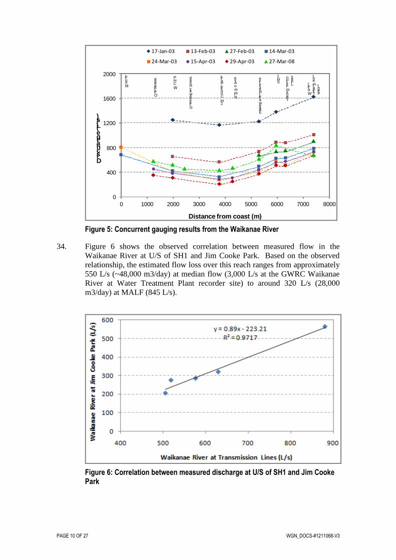
B Scope of this report
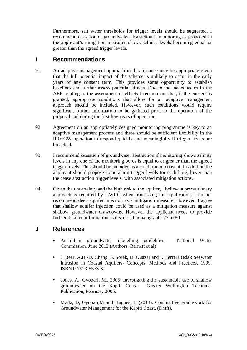
9. This report focuses on the groundwater technical aspects of the Kapiti Water Supply AEE (and associated documents) submitted by KCDC. The report includes:
(a) A description of the River Recharge with Groundwater (RRwGW) proposal;
(b) A brief description of the Kapiti Coast groundwater management zones and groundwater flow system;
(c) A brief overview of the receiving environment, including the effects of the existing abstractions;
(d) Review of the construction and calibration of the applicants groundwater model to assess the level of confidence which can be invested in the models ability to characterise and quantify the effects of the proposed activity, particularly in regards to freshwater ecosystems.
(e) An evaluation of the applicant’s proposed monitoring and options for mitigating the effects of their proposal;
(f) A brief summary and evaluation of matters raised by submitters in relation to the proposal, particularly in terms of monitoring and managing the effects of the abstractions on surface water systems and saltwater intrusion potential.
(g) Recommendations on granting the consent applications and draft consent conditions that provide a regulatory framework for managing and monitoring the effects of the proposal on the receiving environment.

WGN_DOCS-#1211068-V3 PAGE 3 OF 27
10. In addition to the original and revised AEE documents, I have reviewed the following supplementary material:
• Beca 2012. Kapiti Water Supply Project: River recharge with groundwater. Volumes One (Summary Report), Two (Assessment of Environmental Effects Report) and Three (Technical Reports). Prepared for Kapiti Coast District Council by Beca, November 2012.
• Beca 2013a. Response to Greater Wellington Regional Council’s request for further information under section 92(1) of the Resource Management Act. Prepared by Beca (Beca reference#NZ1-7012332-3 0.3), dated 11 February 2013.
• Beca 2013b. Draft monitoring plan. Summary tables prepared by Beca (Beca reference#NZ1-7149772-4 0.4), dated 13 March 2013.
• Beca 2013c. Response to S92 questions relating to hydrology. Prepared by Michael Law, Beca (Beca reference#NZ1-7171059-7 0.7), dated 20 March 2013.
• CH2M Beca Limited, 2012. Kapiti Coast – Revised Aquifer Testing and Groundwater Modelling. Prepared for Kapiti Coast District Council 7th November, 2012.
11. Other reports and material consulted in the preparation of this report are cited in the text and listed in the references section at the end of the report.
12. Comments in this report are limited to groundwater hydrology. Technical material relating to hydrology, river and stream water quality and ecology, wetland ecology and hydrology has been reviewed by Thompson (2013), Perrie (2013) and Myers (2013), respectively.
C Summary of the proposal
13. The consent application describes the proposed activity in detail and will be summarised in the section 42a officer’s report. My comments here are restricted to describing the actual and potential effects of the activity and assessing the applicant’s proposed monitoring and mitigation measures. In doing so, I have recognised the importance of KCDC’s water supply strategy, but I also understand the importance of protecting the quality of the Kapiti Coast’s environment.
14. The applicant is seeking a replacement consent for surface water abstraction from the Waikanae River, groundwater abstraction from the Waikanae borefield and, at the same time, authorisation to discharge groundwater to the Waikanae River and also inject some of the water into deep and shallow aquifer systems.
15. While reference is made to the River Recharge with Groundwater proposal, it is important to recognise that the applicant has a current consent to abstract up to two-thirds of their proposed groundwater take. However, it is also

PAGE 4 OF 27 WGN_DOCS-#1211068-V3
recognised that the applicant has not fully exercised the consent to abstract the total consented amount for the consented duration in any given year. It is not known what environmental effects could have resulted if the applicant had fully exercised their current consent.
16. The applicant currently has authorisation (i.e., resource consent) to take up to 23,200 m3/day of groundwater from the deep aquifers in the Kapiti Coast. The well field is centred in the current Waikanae groundwater management zone but extends from the Raumati/Paekakariki to the Coastal and Otaki groundwater management zones i.e from Peka Peka Road in the north to approximately 1km south of the Waikanae River. Hence the proposed scheme will affect groundwater allocations in three other groundwater management zones.
17. As part of the new consents, the applicant proposes to undertake more comprehensive monitoring of the receiving environment. This includes the monitoring of:
• Water levels in wetlands that are identified as having greater impacts from the proposed RRwGW
• Stream flow gauging in streams that have been identified as being at greater risk of depletion due to the proposed RRwGW, and
• Salinity/saltwater intrusion monitoring for shallow and deep aquifers using dedicated monitoring wells.
18. As part of the new consent, the applicant has proposed an adaptive management approach in which adverse effects are mitigated as they occur. Under the adaptive management process the following responses are proposed:
Proposed adaptive management for large drawdowns below streams and wetlands: 19. The applicant has proposed mitigation measures such as bore reconfigurations
and decommissioning of bores in areas where adverse effects are observed. The applicant has also proposed injection of river water to the shallow aquifer and engineering measures to minimise adverse declines in wetland water levels.
Proposed adaptive management for large drawdowns in deep aquifers 20. The applicant has proposed mitigation measures such as bore reconfigurations
and decommissioning of bores in areas where adverse effects are observed. The applicant has also proposed injection of river water to the deep aquifer.
Proposed adaptive management for control of saltwater Intrusion 21. The applicant has proposed mitigation measures such as bore reconfigurations
and decommissioning of bores in areas where adverse effects are observed. The applicant has also proposed injection of river water to the deep aquifer.
D Description of the environment
22. This section provides a brief description of the hydrogeological environment of the project area, focussing on areas covered by the applicant’s new borefield.

WGN_DOCS-#1211068-V3 PAGE 5 OF 27
The discussion includes a description of the hydrogeology of the Waikanae area including discussion of the proposed GWRC revision of groundwater management zones on the Kapiti Coast. For descriptions of the hydrological (Waikanae River and smaller streams), wetland and ecological environments, refer to peer review reports of Thompson (2013), Myers (2013) and Perrie (2013), respectively.
Conceptual Hydrogeology of Waikanae 23. The Waikanae groundwater zone hosts an extensive groundwater resource in a
complex, relatively heterogeneous sequence of later Quaternary alluvial materials.
24. The Holocene (Q1) sand and gravel deposits form an extensive unconfined aquifer system which is recharged by local rainfall as well as flow loss from the Waikanae River. The aquifer system is also hydraulically connected to numerous wetlands and streams on the coastal plain.
Alluvial fan
K = 5-10 m/day
Holocene sandK = 1-2 m/day
Q1 gravelsK = 250 m/day
Greywacke Basement
Keff = 0 m/day
Q6 gravel and sand
K = 5-10 m/day
Sideslopeinf iltration
Offshore discharge
Rainfall recharge
Wetland Evaporation/ET
Waikanae River loss550 L/s
Lowland stream basef low/springf low = 250 L/s
Diffuse Leakage
Offshore throughflow?
Figure 1. Conceptual Description of the Waikanae Hydrogeology
25. Limited vertical hydraulic gradient is observed between individual water-bearing layers throughout the entire stratigraphic sequence although both responses to seasonal recharge and abstraction can vary both spatially and with depth reflecting the heterogeneity of the alluvial materials. Groundwater levels on the basement high (i.e. ~east of Ngarara Road) appear to respond in a very similar manner to seasonal recharge suggesting relatively good hydraulic connection across the entire sedimentary sequence, possibly due to the irregular occurrence of the lower hydraulic conductivity Q5 sediments in this area and the geometry of the basement ‘ridge’. To the west, the deeper Q6 aquifer appears to be relatively well confined by the overlying Q5 sediments exhibiting different seasonal response to the overlying Q2 aquifer. However, in places the Q5 materials appear to exhibit sufficient hydraulic conductivity to allow appreciable vertical leakage in response to large-scale pumping induced drawdown in the Q6 aquifer.

PAGE 6 OF 27 WGN_DOCS-#1211068-V3
26. The underlying sequence of Q2 to Q6+ alluvial materials form a thick stratified aquifer system. Along the coastal margin these deposits can be separated into three distinct water-bearing units (the Q2, Q4 and Q6 aquifers respectively) which are separated by accumulations of predominantly fine-grained (sand and silt) materials. These units restrict the hydraulic connection between successive water bearing intervals resulting in progressively lower rates of groundwater flow circulation through the deeper aquifer system. However, the similarity in piezometric head observed throughout the stratigraphic sequence indicates sufficient vertical hydraulic conductivity exists to allow leakage to occur in response to fluctuations in the aquifer water budget (e.g. recharge or abstraction).
27. Groundwater levels in the Holocene (Q1) sand respond to localised rainfall recharge exhibiting the characteristic short-term hydrograph response observed in these deposits along the entire coastal margin of the Kapiti Coast.
Water Balances 28. Information indicates infiltration of rainfall and runoff from the Tararua
foothills is a significant source of recharge to the Q1 sand aquifer. Streamflow gaugings also indicate a flow loss of approximately 550 L/s from the Waikanae River to the surrounding Q1 alluvium between U/S of SH1 and Jim Cooke Park, as shown in Figure 7. A proportion of the flow loss from the Waikanae River appears to flow along the former channel of the ‘Waimeha River’ and emerge in headwater springs in the Waimeha Stream which carries a discharge of approximately 150 L/s. Appreciable baseflow discharge also occurs in the lower reaches of the Waikanae River (possibly of the order of 300 L/s) as well as the Mazengarb Drain (~50 L/s) and Ngarara Stream (30 L/s). An unknown component of groundwater throughflow is discharged offshore, although the observed reduction in piezometric gradient along the coastal margin may suggest that vertical leakage in this area may be a more important component of the water balance in the Q6 and Q2 aquifers.
Shallow and deep groundwater level responses 29. Figure 2 shows the fluctuations of shallow and deep groundwater in response
to seasonal recharge. It is shown that the fluctuations are synchronous reflecting that both shallow and deep groundwater respond as a unit and are both responsive to natural seasonal recharge.

WGN_DOCS-#1211068-V3 PAGE 7 OF 27
Figure 2: Groundwater levels recorded in bores on the eastern side of the coastal plain
30. The equalisation of piezometric head between bores of varying depths suggests vertical hydraulic connection (i.e. leakage) between water-bearing intervals across a majority of the stratigraphic sequence. This is consistent with the observation of (limited) drawdown in shallow bores during aquifer testing undertaken on KCDC production bores screened in the Q6 layer (URS 2003, Beca 2010).
31. However, figure 3 shows that the degree of interconnection between individual water bearing layers can vary both spatially and with depth reflecting the overall hetereogeneity of the alluvial materials. This figure shows drawdown in response to abstraction from the Q6 aquifer during March 2008 of up to ~3 metres in R26/6378 (110 metres deep) reflecting localised pumping effects. During this period a drawdown (~1 metre) was observed in the WCHP deep observation bore (R26/6594, 76 metres) while limited response was observed in the shallow monitoring bore at the same site (R26/6916, 19 metres). In contrast, at the KCDC Estuary monitoring site approximately 0.4 metres drawdown was observed in the shallower piezometer (R26/6956, 52 metres) while drawdown was less than 0.1 metres in the deeper piezometer at the same site (R26/6566, 76 metres).

PAGE 8 OF 27 WGN_DOCS-#1211068-V3
Figure 3: Drawdown in response to abstraction from the Q6 (Waimea) aquifer, Jan to May 2008
Groundwater/surface water interaction 32. The Waikanae River drains the western slopes of the Tararua Range and flows
across the coastal plain in the vicinity of Waikanae Beach. Other streams draining the Waikanae groundwater zone include the Ngarara Stream which drains wetland areas on the coastal plain north of Waikanae, the spring-fed Waimeha Stream originating on the paleochannel of the ‘Waimeha River’, the Mazengarb Drain which drains the coastal plain south of the Waikanae River and the Wharemauku Stream which flows from the Tararua foothills reaching the coast at Raumati Beach. Figure 4 shows the location of concurrent flow gauging sites in the Waikanae area.

WGN_DOCS-#1211068-V3 PAGE 9 OF 27
Figure 4: Concurrent gauging sites in the Waikanae groundwater zone
33. Gauging data indicate significant interaction between the Waikanae River and surrounding Q1 gravels. As illustrated in Figure 5, data indicate appreciable flow loss over the reach between U/S of SH1 and Jim Cooke Memorial Park1. During periods of low flow gauged losses over this reach are generally of the order of 300 L/s (26,000 m3/day) which may account for between 40 to 60 percent of the upstream flow. The few gauging data in the lower section of the river indicate an increase in flow reflecting baseflow discharge to lower reaches of the river from the surrounding unconfined aquifer.
1 Both sites located downstream of KCDC water supply intake so observed flow variation not affected by abstraction
PAGE 10 OF 27 WGN_DOCS-#1211068-V3
0
400
800
1200
1600
2000
0 1000 2000 3000 4000 5000 6000 7000 8000
Discharge (L/s)
Distance from coast (m)
17-Jan-03 13-Feb-03 27-Feb-03 14-Mar-03
24-Mar-03 15-Apr-03 29-Apr-03 27-Mar-08
Mouth
Otaihanga
WCHP
Greenaway Road
Jim Cooke Park
NimmoAve
Edgewater Reserve S
H1
Transmission
Lines
Water
Treatment
Plant
Figure 5: Concurrent gauging results from the Waikanae River
34. Figure 6 shows the observed correlation between measured flow in the Waikanae River at U/S of SH1 and Jim Cooke Park. Based on the observed relationship, the estimated flow loss over this reach ranges from approximately 550 L/s (~48,000 m3/day) at median flow (3,000 L/s at the GWRC Waikanae River at Water Treatment Plant recorder site) to around 320 L/s (28,000 m3/day) at MALF (845 L/s).
Figure 6: Correlation between measured discharge at U/S of SH1 and Jim Cooke Park

WGN_DOCS-#1211068-V3 PAGE 11 OF 27
35. A proportion of the throughflow occurring in the Q1 gravel aquifer adjacent to the Waikanae River is interpreted to follow the paleochannel of the ‘Waimeha River’ and discharge into (what is now) the Waimeha Stream. As illustrated in Figure 7, flow in the Waimeha Stream increases rapidly in its headwaters downstream of Park Avenue, with typical discharge of approximately 150 L/s at Te Moana Road indicating significant baseflow discharge over this reach.
Figure 7: Concurrent gauging results from Waimeha Stream, 27 March 2008
36. The Ngarara Stream drains the Te Harakeke and Nga Manu wetlands which occur on the coastal plain north of Waikanae. Limited flow gaugings on the Ngarara Stream indicate that the flow upstream of the Waimeha Stream confluence ranges from 30 to 400 L/s. Due to the ephemeral nature of runoff to this stream (with a significant contribution from urban stormwater), it is assumed that the lower figure represents the likely magnitude of baseflow discharge from shallow groundwater during summer conditions.
37. The Mazengarb Drain is a similar stream which drains the coastal plain south of the Waikanae River. Jones and Gyopari (2005) suggested a groundwater contribution of the order to 50 L/s to the lower reaches of this stream.
38. Waikanae groundwater zone hosts a number of significant wetland areas on the coastal plain both north and south of the Waikanae River (Figure 15). Jones and Gyopari (2005) note that these ecosystems are largely sustained by groundwater inflow in areas where the water table in the Holocene (Q1) sand aquifer intersects (or lies close to) the land surface, particularly in interdunal depressions. In localised areas, evaporation from open water and evapotranspiration from wetland vegetation may comprise a relatively small component of the overall water budget in the unconfined aquifer which increases in significance during extended periods of low rainfall.

PAGE 12 OF 27 WGN_DOCS-#1211068-V3
Saltwater Intrusion 39. Current monitoring shows that saltwater is present in the coastal zones in the
Waikanae area. Table 3-2 of Volume 2 Appendix 5 (Monitoring Manual –Waikanae borefield, URS 2010) of the application lists the electrical conductivity ranges in coastal monitoring bores. An analysis of electrical conductivity from the key monitoring wells clearly shows that saline water is present in the Waikanae borefield. Rutherford Drive well located 600m from the coast, Estuary shallow and deep bores located approximately 300m from the coast (PW1-MW1/1 and PW1-MW1/2 which are screened between 52-53.5m and 76-78m deep, respectively). The tables show conductivity values of about 6,000 and 10,000 µS/cm (freshwater <1,000 µS/cm). This indicates the potential presence of the saltwater interface close to the shoreline.
Recent GWRC groundwater investigations and proposed management zone revision
40. GWRC has recently undertaken investigations and modelling work to develop a methodology for the conjunctive management of groundwater and surface water for the Kapiti Coast. This work is being undertaken to inform policy on allocable volumes of groundwater within the Kapiti Coast aquifer system. The methodology proposes significant modifications to the existing GWRC Regional Freshwater Plan (RFP)2 in the way that the region’s freshwater resources are allocated to ensure that they are sustainable.
The framework makes provision for the regulation of groundwater pumping in order to mitigate immediate effects on freshwater ecosystems (streams, rivers, springs and wetlands). It also considers the longer-term cumulative effects of groundwater abstraction on the surface water environment on a catchment-wide scale to establish sustainable groundwater allocation limits.
The objectives of the investigation are to:
• Review and revise the conceptual hydrogeology of the Kapiti Coast;
• Characterise and quantify the flow dynamics and waters balances of the various aquifers;
• Characterise groundwater and surface water connectivity;
• Quantify groundwater abstraction effects on surface water ecosystems;
• Review and revise groundwater management zones;
The work has resulted in the reduction of the Kapiti Groundwater Management zones from the existing six zones to the proposed four zones. Figure 1 shows the extent of the existing and proposed zones.
2 WRC (1999)

WGN_DOCS-#1211068-V3 PAGE 13 OF 27
Figure 8. Existing and Proposed Kapiti Coast Groundwater Management Zones
41. The applicant’s proposed activity is centred within the proposed Waikanae groundwater management zone but extends further south to parts of the Raumati groundwater management zone and north to parts of the Te Horo groundwater management zone. Figure 2 shows the areal extent of the Waikanae groundwater management zones and also a general distribution of surface water features such as streams and wetlands.

PAGE 14 OF 27 WGN_DOCS-#1211068-V3
Figure 9. The proposed Waikanae Groundwater Management Zone (Approximate Coverage of the Applicant’s borefield)
D Adequacy and completeness of information
General Assessment 42. The applicant has undertaken a significant amount of work in attempting to
understand the potential effects of the RRwGW proposal. However, I believe that there is still uncertainty around the potential effects of excessive groundwater level drawdown on small streams, wetlands, saltwater intrusion and individual shallow wells. Numerous groundwater dependent ecosystems such as rivers, springs, streams and wetlands occur in the project area showing that there is a high degree of connectivity between the shallow groundwater and surface water environments. Characterisation and quantification of the potential effects of the proposed groundwater abstractions on freshwater ecosystems is therefore an important function of the groundwater modelling and the AEE overall.
43. The applicant has developed a numerical groundwater flow model to simulate the drawdown and interference effects that might be associated with abstraction from the current and proposed wells to evaluate the long term feasibility of the RRwGW option. Other purposes of the model were to identify where effects

WGN_DOCS-#1211068-V3 PAGE 15 OF 27
would occur, design a monitoring programme to measure the effects at these locations, and develop a mitigation strategy as part of an adaptive management approach.
44. The model forms a fundamental basis for the technical evaluation of the potential environmental effects associated with the RRwGW proposal. A strongly implicit purpose of the model is also to assess potential effects on the shallow groundwater environment and connected freshwater ecosystems. I had reservations about the calibrations of the applicant’s model mainly resulting from imposed aquifer boundary conditions (edge effects) and recharge calculations.
45. GWRC, as part of the investigations for the development of the Kapiti water allocation conjunctive framework, has also recently developed a model of the Kapiti aquifer systems. The applicant and GWRC have been in discussions with regards to shared data for input into their respective models. GWRC sent to the applicant’s consultants (Beca Ltd) their draft model calibration report as part of the data sharing agreement. However, following the meeting of 14 September 2012 and a telephone conversation between Mark Utting and Doug Mzila (GWRC), Beca Ltd withdrew the groundwater report for further work. The applicant re-submitted the groundwater report (dated 7 November 2012) as part of Volume 3: Technical Reports).
46. It is recognised that all groundwater flow models have degrees of uncertainty. GWRC and the applicant held several meetings to address identified limitations with the modelling work. Discussions between the applicant and GWRC reduced but did not entirely eliminate concerns related to the applicants groundwater modelling. However, GWRC and the applicant agreed that the results from the two models could be used to inform monitoring and mitigation. The applicant submitted data to GWRC to model stream depletion and depletion below identified wetlands. This modelling exercise was undertaken by GWRC on a non-committal basis.
47. Results showed areas of disagreement between the models in the calculated drawdowns below identified wetlands. However, the differences between GWRC and the applicant were not considered critical. The modelling is used to provide guidance on areas potentially affected by the activity for the purposes of informing proposed monitoring rather than the magnitude of drawdown. Since the applicant has not modelled stream depletion effects, the GWRC model results have been accepted by the applicant to provide guidance for targeted stream flow monitoring.
Construction and calibration of the applicant’s model 48. The following is a review on the construction and calibration of the applicant’s
model to assess the level of confidence which can be invested in the model’s ability to characterise and quantify the effects of the proposed activity, particularly in regards to freshwater ecosystems.
49. The applicant has used the USGS finite difference code MODFLOW for groundwater modelling. The model grid size is variable to provide for better resolution of land use and river features without greatly affecting the

PAGE 16 OF 27 WGN_DOCS-#1211068-V3
dimensionality of the model (i.e. with greatly increasing model run times and file sizes). The overall model domain extends offshore to allow for leakage to the sea as a dominant discharge process. The vertical grid discretisation adequately represents the conceptual hydrogeologic framework. The modelling work was stated to incorporate recommendations made by GNS Science who were commissioned by the applicant to peer review an earlier model developed for the client. The applicant has not allowed GWRC access to this peer review and has instead provided their own summary table (Appendix 3 of Volume 3 ).
50. The geology and hydrogeology in the model presents a reasonable level of understanding and conceptualisation of the groundwater environment. Large volumes of geological and hydrogeological data were collected and analysed to characterise the three dimensional structure of the area. This data is presented as a series of cross sections. The data included the drilling and pump testing of exploration wells. Analysis of pumping test data appears to be of good quality.
51. Boundary condition placement and assignment have been of particular interest in this review since they can critically influence the calibration and subsequently affect the predictive behaviour of the model. Discussions were held with the applicant with regard to the placement of boundary conditions and edge effects.
52. The calculation of recharge in the model is unclear. The methodology for calculating recharge is not documented and appears to have been based on a previous modelling study (Jones and Gyopari, 2005). The earlier GWRC study employed a daily soil moisture balance methodology but the report provides no explanation as to how the Beca model has used this. I consider that reliance on an older model for recharge input is not ideal and that recharge should be an adjustable calibration parameter. I therefore consider the model to be deficient in terms of rainfall recharge calculation since model calibration is highly sensitive to this parameter.
53. In addition to recharge calculation it is generally standard practice to conduct independent water balance calculations (conceptual and semi-quantitative inflows and outflows) in order to verify the model and also to minimise non-uniqueness issues which affect most models. Such an approach does not seem to have been adopted or reported.
54. Other identified weaknesses of the model included the following:
(a) Impact of no-flow boundary interference for pumping test calibrations;
(b) The lack of reported water balance outputs and comparison/verification to observed temporal river loss/gain patterns or spring/drain flows;
(c) There was no evidence that the transient model is adequately simulating the interaction between the Waikanae River and underlying aquifer.

WGN_DOCS-#1211068-V3 PAGE 17 OF 27
(d) Justification for fixing a constant stage in the Waikanae River during the transient calibration and how this affects river-aquifer fluxes;
(e) The assumption of laterally continuous aquitards with very low vertical hydraulic conductivity above the pumped aquifer which control drawdowns in the unconfined aquifer and lack of sensitivity analysis of these.
55. The applicant’s model did not adequately assess the effects of the proposed activity on the small streams that are likely to be connected to groundwater. For this reason the GWRC model was used and five streams wereidentified that may be affected to a potentially significant degree; the Muaupoko Stream, Kakariki Stream, Ngarara Creek, Waimeha Stream and Kowhai Stream. Drawdown-induced depletion rates in these streams (and/or water level declines in the Holocene sands around them) are predicted to be relatively high. The effects on these streams are discussed further in the hydrology report. For this analysis, GWRC has applied worst case drought conditions as supplied by the applicant to calculate stream flow depletions under these conditions.
E Assessment of environmental effects (AEE)
Cumulative effects on the environment 56. The applicant states that cumulative effects from other factors such as land use
changes, climatic changes and drainage changes would not have a significant impact on the proposed activity. I do not agree with this for the reasons that the potential cumulative stresses will change the dynamics of the groundwater flow system (e.g. changes in recharge, groundwater surface-water interactions, sea level etc) and therefore the system would be expected to behave differently under pumping stresses. Furthermore it cannot be assumed that the water demand model would be valid under potentially compounded stress scenarios.
57. The applicant has not defined or proposed any ‘thresholds’ of what they consider might be appropriate or acceptable change in either water quality or measures of ecosystem health other than stating that where a change may occur it may be acceptable. I consider thresholds need to be established that clearly define when an effect has occurred and set in motion appropriate mitigation. This is discussed further in subsequent sections of this report.
Effects on Wetlands and Small Streams 58. Relatively little attention has been focussed on characterising groundwater-
surface water interaction – for example the groundwater dependency of various wetlands, spring characteristics, and the losing/gaining patterns in the Waikanae River and other smaller streams. Some existing information is available (for example concurrent gaugings, spring flows, wetland levels), however much of this information has not been presented and there has been no attempt by the applicant to identify and supplement any information gaps.
59. Overall, there appears to have been minimal attempt to characterise groundwater dependent ecosystems which may be affected by this activity. These ecosystems should be the focus of modelled effects, monitoring and mitigation. I also believe that any proposed mitigation methodology must rely

PAGE 18 OF 27 WGN_DOCS-#1211068-V3
upon a sound understanding of the hydrologic functioning of wetland systems in conjunction with a sufficient baseline monitoring record. In the absence of these, an adaptive management approach is difficult to implement. Furthermore, significant (unintentional) damage may result from the artificial manipulation of water levels and potential changes in water quality.
60. The applicant states that drawdown during a 50-year drought would have no further impact on a stream or reach that was dry during the 50-year drought. I do not agree with this assumption as the dependence of surface water on groundwater baseflow has not been established and there is a lack of information on the hydrology of small streams. It is likely that streams are dependent on groundwater sustained baseflow and may not dry up during a 50-year drought scenario. Therefore groundwater drawdowns due to wellfield abstraction could cause flows in small streams to decrease or go dry and prolong the duration of extreme low flows or dry conditions. The magnitude of groundwater drawdown beneath the stream bed could therefore be important. Rainfall will cause a quick response on surface flows which may recede rapidly in the absence of baseflow and a depressed water table.
Saltwater intrusion potential 61. The applicant recognises that the proposal may increase the risk of saline
intrusion because the borefield is located close to the coast and abstracts water primarily from the Waimea and lower Pleistocene Sand Aquifers, which underlie a system of leaky alluvial aquifers (as shown in Figure 3). However, the applicant states that the risk of saltwater intrusion from the proposal is very low due to the following:
• The contact (location of the interface) of the aquifers with seawater is expected to be some several kilometres offshore;
• The borefield will have a setback of at least 1km from the coast.
• Water quality samples from wells N1, N3, S1, S3 and KCDC production wells do not indicate the presence of sea water at depth;
• Water level recovery occurs after pumping ceases such that groundwater returns to its “normal” off-shore direction.
• Proposed mitigation measures that include reconfiguring bore use, decommissioning bores, creating new bores to spread the effects and aquifer injection.
These points are discussed further in the remainder of this section.
62. Location of the interface: I do not agree that the saltwater/freshwater interface is located several kilometres off-shore. GWRC monitor conductivity in a number of saline intrusion sentinel wells in the Waikanae area on behalf of KCDC. GWRC have used conductivity values from the newly installed replacement conductivity sensors to provide clarity on currently observed conductivity values at key locations. The new sensors have been factory calibrated and field verified and are accurate to within 2% of the

WGN_DOCS-#1211068-V3 PAGE 19 OF 27
measurements. The new data was used to plot the lateral distribution of conductivity from the coastline to a distance of approximately 750m. Electrical conductivity at the coastline was assumed to be 30,000µS/cm. Figure 10 shows the changes in conductivity with distance from the coastline. From this figure it is clearly evident that the saltwater wedge is located within the aquifer. Furthermore, the applicant (personal communications with Mark Utting) analysed groundwater chemistry for the deep aquifers in the Waikanae area and concluded that groundwater with seawater signatures extends more than 2km onshore. This analysis is consistent with observed plots of electrical conductivity i.e. if the graph is extended further to 2 km.
Figure 10. Electrical Conductivity and groundwater elevation with distance from the coastline.
63. Setback Distances: Further analysis on potential movement of the interface with decline in natural or artificial groundwater levels was undertaken on the Rutherford Drive well. The well is located approximately 750m from the coastline. The Rutherford Drive well has a screen depth of between 110-122m, the conductivity sensor in this well is at a depth of 108m (i.e. within the casing). A new sensor has been installed at this location, the old sensor showed erratic conductivity results which were about 200µS/cm higher than calibration standard solutions and readings from the new sensor. The new sensor has been calibrated and showed conductivity values with an error of less than 2%. Figure 11 is a plot of changes in electrical conductivity with changes in groundwater levels for the period September 2012 to May 2013. The figure clearly shows that electrical conductivity responds to groundwater level changes at this location. This implies that sustained groundwater drawdowns have a potential to induce landward movement of the interface and could extend further than the proposed 1 km setback distance.

PAGE 20 OF 27 WGN_DOCS-#1211068-V3
Figure 11 Groundwater level and conductivity changes (Rutherford Drive Well)
64. As stated in paragraph 61, the applicant analysed groundwater chemistry for the deep aquifers in the Waikanae area and concluded that groundwater with seawater signatures extends more than 2km onshore. There is a need for detailed investigations on the source of the seawater in these areas. Consequently, a precautionary approach is strongly advised.
65. In the AEE, the applicant states that there is no indication of seawater at depth. I do not agree with the statement with this statement for the reasons that as stated in paragraph 61, the applicant analysed groundwater chemistry for the deep aquifers in the Waikanae area and concluded that groundwater with seawater signatures extends more than 2km onshore. There is a need for further detailed investigations on the source of the seawater in these areas. Furthermore, the current well field has not been extensively used and the abstracted volumes are relatively minor when compared to the proposed takes.
66. The applicant states that water level recovery occurs after pumping ceases such that groundwater returns to its “normal” off-shore direction infers that groundwater recovery would result in pushing back any saltwater intrusion. I do not I agree with this simplistic approach. If reestablishment of groundwater levels was efficient in repulsing saltwater intrusion, the aquifer could have been flushed of any saline water that is evidently present. Therefore higher groundwater level may not result in quick recovery of the aquifer from saline water contamination.
67. The AEE proposes an adaptive management approach to saltwater intrusion mitigation. In my opinion, the stated mitigation measures are not adequate. The applicant has modelled worst case aquifer drawdown of more than 10m along

WGN_DOCS-#1211068-V3 PAGE 21 OF 27
the coastline. Moving the bores further inland is stated to reduce drawdown to about 5m. In my opinion the saltwater/freshwater interface is currently in a precarious equilibrium, any sustained groundwater abstraction could result in rapid and almost irreversible aquifer contamination from saline water. Figure 11 shows that any increase in drawdown will result in increases in conductivity.
68. I do not agree with the proposed deep aquifer injection as a mitigation measure. This is discussed further in section G below.
F Comments on submissions
69. I have reviewed the summary of submissions. My comments are on aspects of
the submissions that relate to groundwater drawdown effects on the environment including potential for saltwater intrusion. The submitter comments on groundwater fall into five basic categories:
1) Saltwater intrusion; 2) Aquifer injection; 3) Excessive drawdown in domestic wells; 4) Monitoring and adaptive management measures 5) Effects on wetlands and surface water
I regard that most submitters have valid comments and are informed on the proposed RRwGW.
Potential effects on wetlands and surface water 70. Eleven submitters showed some concern about the effects of the proposed
RRwGW on wetlands and surface waters. I agree that the concerns are valid, it is also my opinion that the applicant did not reasonably characterise surface water and groundwater connectivity as a basis for assessing the effects of the proposed RRwGW. However, I do believe that further investigations and baseline monitoring of small streams and wetlands could be undertaken as a condition of consent to provide data to address this information gap.
Potential effects on other groundwater users 71. Nine submitters commented on the potential effect of groundwater drawdown
on domestic wells and how the applicant is going to provide mitigation against excessive individual well drawdowns that may result in loss of useable well heads. In my opinion these are valid concerns that the applicant should be required to address. The applicant, through investigations and modelling has identified a number of wells that may be affected by large drawdowns due to the proposal. There is a lot of uncertainty with the developed model and there is a possibility that not all wells that may be at risk were identified. I think the concerns could be addressed if the applicant could make a provision to respond to drawdown effects as they occur.

PAGE 22 OF 27 WGN_DOCS-#1211068-V3
Potential for saltwater intrusion 72. Five submitters have raised concerns about the potential risk of saltwater
intrusion resulting from aquifer drawdown. I agree this is a valid concern, about which I have discussed in previous sections. The applicant has proposed mitigation measures against saltwater intrusion which I regard not to be adequate to mitigate against saltwater intrusion.
Potential risk from aquifer injection 73. Five submitters have raised concerns about the potential risk of aquifer
injection to control excessive groundwater level drawdowns. I do agree that aquifer injection to deep groundwater is of concern. However, I believe aquifer recharge could be used to control shallow groundwater drawdown. The applicant would need to prove that this mitigation measure has benefits. I am concerned that the injection is proposed for the winter and spring when the effects have already ‘passed’.
G Draft monitoring plan, mitigation and proposed consent conditions
Draft monitoring plan 74. Overall the applicants draft monitoring plan lacks sufficient detail to enable a
comprehensive review; with that in mind I have outlined the following comments and/or questions that should be given further consideration or require clarification. Given the uncertainty of the effects of the proposal on the groundwater hydrology, groundwater/surface water interactions and risk of saltwater intrusion, the proposed monitoring plan should be comprehensive and its development will require significant consultation with GWRC and stakeholders.
Mitigation against excessive groundwater level decline in aquifers 75. An adaptive management approach can be taken to ensure that adverse effects
to the environment can be minimised, provided that an appropriate monitoring programme is agreed and that there is sufficient flexibility in the borefield operation to reduce the level of impact should agreed trigger levels be breached. I agree with the proposed measures, locations, frequency and methods for monitoring as outlined in the draft monitoring plan. However, there are issues around the proposed responses and adaptive management measures, which are discussed below.
76. The applicant’s draft monitoring plan requires that if adverse environmental effects are considered to be due to the proposal then measures will be assessed for implementation by the adaptive management committee. The applicant would need to provide information to show that effects are due to the proposal. The proposed adaptive management measures generally fall into the following four categories and in order of preference:
1) Reconfigure bore use (reduce take from bores near the affected area).
2) Aquifer injection.

WGN_DOCS-#1211068-V3 PAGE 23 OF 27
3) Decommission bores or create new bores in other areas.
4) Replace or upgrade affected bores.
77. I agree that the proposed adaptive management measures (1, 3 and 4 above) are conceptually valid as options for controlling or mitigating drawdowns in aquifers with direct hydraulic connections with wetlands and streams. However, I have concerns with regards to deep aquifer injection as a mitigation measure. I do not recommend deep aquifer injection as an appropriate mitigation measure due to the high risk of aquifer contamination and also of the slow recovery of the aquifer from such contamination. I note in the applicant’s AEE, aquifer injection was originally rejected by KCDC due to high risk of aquifer contamination and this method of Aquifer Storage and Recovery (ASR) has not been tested under New Zealand conditions. Furthermore, the lateral extent and hydrogeology of the Waikanae aquifer system does not permit for adequate travel times between the injection and abstraction wells. The applicant also proposed to use abstraction wells for injection. In my opinion this proposal further compounds the risks associated with deep aquifer injection.
78. I consider that any contaminants that may be in the river water introduced into the deep aquifer from injection would be difficult to flush out. Deep aquifer injection has a high risk potential and furthermore it has not been tested under New Zealand conditions. Furthermore, the applicant has stated that the aquifer recovers rapidly from recharge. What then would be the purpose of aquifer injection in winter and spring when the effects would have passed?
79. However, I agree that shallow aquifer injection could be used as a mitigation measure against shallow groundwater drawdowns. However, the applicant needs to provide further detailed information. The timing of shallow aquifer injection as a mitigation measure has not been explained. The applicant needs to provide information on environmental benefits of the proposed injection as compared to natural recharge. The following are some of the issues the applicant would need to discuss in detail:
• The selection of this mitigation measure noting that KCDC rejected ASR as a groundwater resource augmentation measure due to the risk and uncertainty and the relative untested nature of this approach in New Zealand.
• Proximity of aquifer injection to areas of demand including seasonal demand
• Suitable quality of source water
• Available storage capacity for recharge water storage in the aquifer
• Potential rate of aquifer recharge and mounding
• Residence times (timing of recharge against effects)

PAGE 24 OF 27 WGN_DOCS-#1211068-V3
• Potential effects on other water users
• Potential flooding effects
• The effectiveness of winter and spring injection. The aquifers and groundwater levels in the Waikanae recover relatively quickly to autumn and winter rainfall. What would be the objective of recharge when the aquifers would have fully recovered naturally?
The above information is critical to enable a complete assessment of aquifer injection as a mitigation measure against excessive shallow groundwater level drawdown and therefore must be provided by the applicant before this activity is undertaken.
80. I believe that there is still some uncertainty around the potential effects of excessive groundwater level drawdown on small streams, wetlands, saltwater intrusion and individual shallow wells. Numerous groundwater dependent ecosystems such as rivers, springs, streams and wetlands occur in the project area showing that there is a high degree of connectivity between the shallow groundwater and surface water environments. Mitigation measures can only be developed when there is an understanding of the interactions between shallow groundwater and surface water systems. Further investigations to characterise relationships between shallow groundwater and surface water would need to commence in the early years of any consenting period, should the consent be granted.
Saltwater Intrusion 81. The applicant’s monitoring plan proposes to mitigate groundwater drawdown
by reconfiguring bore use, aquifer injection and/or relocating bores to spread the effects.
82. I question the viability of reconfiguring bore use or relocating bores to mitigate the risk of saltwater intrusion. Considering the applicant’s model results as presented in Appendix Three of the applicant’s technical reports (Figures D6-D11) and GWRC’s predictions, it does not appear that it would be possible to avoid large drawdowns at the coast by moving or reconfiguring the bores. The applicant’s model indicated that the highest drawdowns could be reduced from 10m to 5m by moving the pumping centres inland by 1 km. I still consider that the drawdown would still be high and could therefore result in saltwater intrusion into the aquifer.
83. The applicant presented aquifer injection as a conceptually feasible option to reduce aquifer drawdown and mitigate against potential seawater intrusion. I do not agree with this mitigation measure. Deep aquifer injection has the highest potential for aquifer contamination due to absence of purification processes related to unsaturated soil conditions. Furthermore, the quick aquifer recovery, as stated by the applicant, would result in winter and spring groundwater levels fully recovering from any preceding aquifer drawdowns due to natural processes and thereby making any aquifer recharge redundant.

WGN_DOCS-#1211068-V3 PAGE 25 OF 27
H Recommendations for conditions of consent
84. The following comments relate to what I believe would be required as conditions of consent if this application is to be granted. I have read the proposed conditions by the applicant (Appendix Four, AEE) but given the lack of detail, especially around the monitoring plan and associated conditions, I have therefore just stated the ‘intent’ of what I would expect to be captured by consent conditions. Details around monitoring conditions and suitable methodology require significantly more work by the applicant and these need to be agreed in consultation with GWRC.
85. The applicant proposed to mitigate or minimise the potential effects on streams, wetlands and coastal drawdowns through an adaptive management approach which incorporates a set of monitoring and mitigation measures. Conceptually, I agree that an adaptive management approach can be taken to ensure that adverse effects on the environment can be minimised, provided that an appropriate monitoring programme is implemented.
86. Further information is needed to fully characterise streams that are potentially at risk. Streams that were identified at risk in which baseline monitoring is required are the Waimeha Stream, Ngarara Stream, Kakariki Stream, Mangaone Stream and Kowhai Stream. Furthermore, data collection and possibly further modelling should include the Kowhai Stream and the south tributaries of the Mangaone Stream. Given the uncertainty around some of the effects, these investigations should be carried out in the first few years of any consent, should it be granted, to ensure that adverse effects can be identified early and any changes in mitigation measures are suggested.
87. I consider that regarding shallow aquifer injection the applicant should carry out a desktop study of the geochemistry of mixing river water and shallow groundwater followed by a pilot injection programme as part of the consent condition. This should be carried out before undertaking any shallow aquifer injection..
88. Furthermore, the applicant should provide an explanation on the benefits of winter and spring injection (artificial recharge) when compared to natural recharge occurring during this time. This information is required to adequately assess the application for aquifer injection to mitigate against shallow groundwater drawdown. This information should be provided prior to any hearing.
89. The applicant should undertake a sufficient ecological and hydrological investigation of targeted wetlands to collect baseline information. Given the uncertainty around some of the effects, these investigations should be carried out in the first few years of any consent, should it be granted, to ensure that adverse effects can be identified early of any consenting period and any changes in mitigation measures could be suggested.
90. The applicant should construct or upgrade the current saltwater monitoring wells such that data from these wells is of a high standard and appropriate for conductivity measurements, purging and also collection of samples.
PAGE 26 OF 27 WGN_DOCS-#1211068-V3
Furthermore, salt water thresholds for trigger levels should be suggested. I recommend cessation of groundwater abstraction if monitoring as proposed in the applicant’s mitigation measures shows salinity levels becoming equal or greater than the agreed trigger levels.
I Recommendations
91. An adaptive management approach in this instance may be appropriate given that the full potential impact of the scheme is unlikely to occur in the early years of any consent term. This provides some opportunity to establish baselines and further assess potential effects. Due to the inadequacies in the AEE relating to the assessment of effects I recommend that, if the consent is granted, appropriate conditions that allow for an adaptive management approach should be included. However, such conditions would require significant further information to be gathered prior to the operation of the proposal and during the first few years of operation.
92. Agreement on an appropriately designed monitoring programme is key to an adaptive management process and there should be sufficient flexibility in the RRwGW operation to respond quickly and meaningfully if trigger levels are breached.
93. I recommend cessation of groundwater abstraction if monitoring shows salinity levels in any one of the monitoring bores is equal to or greater than the agreed trigger levels. This should be included as a condition of consent. In addition the applicant should propose some alarm trigger levels for each bore, lower than the cease abstraction trigger levels, with associated mitigation actions.
94. Given the uncertainty and the high risk to the aquifer, I believe a precautionary approach is required by GWRC when processing this application. I do not recommend deep aquifer injection as a mitigation measure. However, I agree that shallow aquifer injection could be used as a mitigation measure against shallow groundwater drawdowns. However the applicant needs to provide further detailed information as discussed in paragraphs 77 to 80.
J References
• Australian groundwater modelling guidelines. National Water Commission. June 2012 (Authors: Barnett et al)
• J. Bear, A.H.-D. Cheng, S. Sorek, D. Ouazar and I. Herrera (eds): Seawater Intrusion in Coastal Aquifers- Concepts, Methods and Practices. 1999. ISBN 0-7923-5573-3.
• Jones, A., Gyopari, M., 2005; Investigating the sustainable use of shallow groundwater on the Kapiti Coast. Greater Wellington Technical Publication, February 2005.
• Mzila, D, Gyopari,M and Hughes, B (2013). Conjunctive Framework for Groundwater Management for the Kapiti Coast. (Draft).

WGN_DOCS-#1211068-V3 PAGE 27 OF 27
• The New Zealand Groundwater model audit guideline - Ministry for the Environment (NZME, 2002);
• URS, 2003; Waikanae/Otaihanga Borefield Drilling Strategy. Report prepared for Kapiti Coast District Council, May 2003.
• URS, 2004; Waikanae Borefield Technical Report. Report prepared for Kapiti Coast District Council, July 2004.
• Welch, C., 2004; Groundwater Recharge from the Waikanae River. BSc (Hons) Thesis, Victoria University of Wellington.