Embed Size (px)
Citation preview

Research Strategy
1. Significance 1.A. Importance of the problem
Malaria is among the most refractory and deadly of infectious diseases. In 2008, the most recent year for which official statistics are available, 243 million cases contributed to 863 thousand deaths.2 While most of this burden of disease is concentrated in sub-Saharan Africa, the Amazon region is the most important reservoir of
the disease in the Americas. Furthermore, the future trajectory of the disease in Amazonia is unclear. The disease was nearly eradicated in Peru during the 1960s, but recent years have seen a striking resurgence, peaking in 1998 (see Figure 1).3 Understanding the forces behind these dynamics is a top-priority public health goal for the region, and is a necessary condition for the future success of malaria control efforts. Existing evidence, while scant, points to an important role for land-use change. For example, a recent study in the Peruvian Amazon found that Anopheles darlingi biting was 278 times higher in deforested sites, relative to sites with intact forest cover. This is particularly important given two long-term secular trends in Amazonia: an expanding road network, and climate
change. Road building is proceeding rapidly in the entire Amazon basin, and with it large-scale deforestation and in-migration.4-7 Anthropogenic climate change is likely to result in substantial
changes in hydrology and fire regimes, with attendant changes in the distribution of malaria vectors.8-11 These trends have the potential to create a surge in malaria akin to that seen in Brazil in the 1970s and 1980s, when malaria cases increased 10-fold.1 These environmental changes are occurring against the backdrop of increasing drug resistance.12
1.B. How we propose to improve scientific knowledge
In addition to the broad public health importance of the proposed research, our study will also address significant gaps in scientific understanding of malaria dynamics. Numerous studies have established linkages between land use and land cover and malaria vector activity.
With only a handful of exceptions, current literature on the influence of demographic and environmental change falls into one of two categories.
o Look at national or regional aggregate data and attempt to infer underlying forces (e.g., work on frontier malaria in Brazil).
o Collect cross-sectional data on we will improve on past efforts by collecting longitudinal data in treatment and control sites in a “natural”
experiment
1.C. Potential impacts of the research
Environmental change affects infectious disease dynamics. Understanding the nature of these effects is critical to disease control efforts, but the complexity of human-ecological-disease systems casts up significant barriers to understanding causality. The proposed study exploits an unusual large-scale perturbation to a malaria-prone ecosystem to formulate a natural experiment that will allow significant new insights into the deforestation-demographics-disease nexus. The imminent construction of the Inter-Oceanic Highway that will link some of the most isolated regions of western Amazonia to the rest of South America, offers an extraordinary opportunity to understand and monitor process of change in communities of vectors of Malaria and other important infectious diseases as land use and land cover changes dramatically, and human
19901992
19941996
19982000
20022004
20060
50,000
100,000
150,000
200,000
250,000
300,000
Figure 1: Malaria cases in Peru, 1990 - 2007 (MINSA)
settlement and use patterns shift due to highway construction. As in other regions of Amazonia, the Inter-Oceanic Highway is expected to result in extensive deforestation, changes in agriculture production from biologically and spatially diverse smallholder-based or indigenous-based systems to large-scale commercial monocropping and livestock production.
2. INNOVATION
2.A. How the proposal seeks to shift current paradigms
Current insight into the environmental and demographic determinants of malaria dynamics come primarily from cross-sectional studies, and are thus vulnerable to familiar problems of causal inference. The proposed work would be the first to exploit a natural experiment to
{this is where we should present current paradigms}
2.B. novel aspects of the proposed research
interdisciplinary scope. We are unaware of other efforts to understand malaria dynamics through the lens of both environmental changes and changes in the
reliance on a natural experiment scope and scale of the environmental perturbation current degree of isolation in the Purus region
2.C. refinements of existing research tools
Anthropogenic alterations of the environment are contributing drivers of emerging and re-emerging infectious diseases in Western Amazonia and other regions that are subject to major infrastructure development (Hunter et al. 1982, Patz et al. 2004, Norris 2004, Keiser et al. 2005). Development projects such as road building and improvements, dam construction, irrigation, changing crop production, mining, and industrialization have all been known to affect mosquito communities, increasing the proliferation and transmission of malaria and other infectious diseases (Tadei et al. 1998, Gratz 1999, Mäki et al. 2001, Singer and Castro 2001, Chaves et al. 2008). A road transforms the physical conditions of the land it is constructed on, as well as the areas adjacent to it (Trombullak and Frisell 2000). Hydrological disruption associated with road building increases the breeding sites available for some vectors species, for example, populations of Anopheles darlingii, the major vector of malaria in Amazonia. A further change introduced by road construction is the decrease in forest cover that has been linked to increased incidence of malaria in several regions of Amazonia (Mäki et al. 2001, Dourojeanni 2006), Vittor et al. 2006). Deforestation first occurs as a direct result of road construction, but more extensive deforestation follows the completion of the road, as the road enables access and settlements of formerly remote areas.
Road development has the potential to change the vector community and the rates of infection within vector communities by combining features, such as deforestation, hydrological shifts, and new and enlarged human settlements (Wolfe et al. 2000, Patz et al. 2000). The increase facility and frequency of human population movements has facilitated the introduction of disease vectors and infectious agents. Migrants can transport a disease endemic to their native locality into non-immune communities. Migrations of this sort have brought malaria to novel regions, and have also been known to move malaria back into regions where it was once eradicated (Martens and Hall, 2000). Disease can also be harbored in communities that have acquired immunity. When migrants colonize and co-inhabit in an area, they are then susceptible to contracting endemic pathogens (Patz et al. 2000). Another way in which migration changes patterns of disease transmission is through the introduction of domestic animals brought from their regions of origin or acquired during transit; for instance when Andean migrants bring their dogs to Amazonia, they may be introducing visceral leishmaniasis to the region (Llanos-Cuentas et al. 1999).
1. Putting it all together – what do we need to know about the environmental determinants of malaria, and what are the important unanswered questions?
3. APPROACH
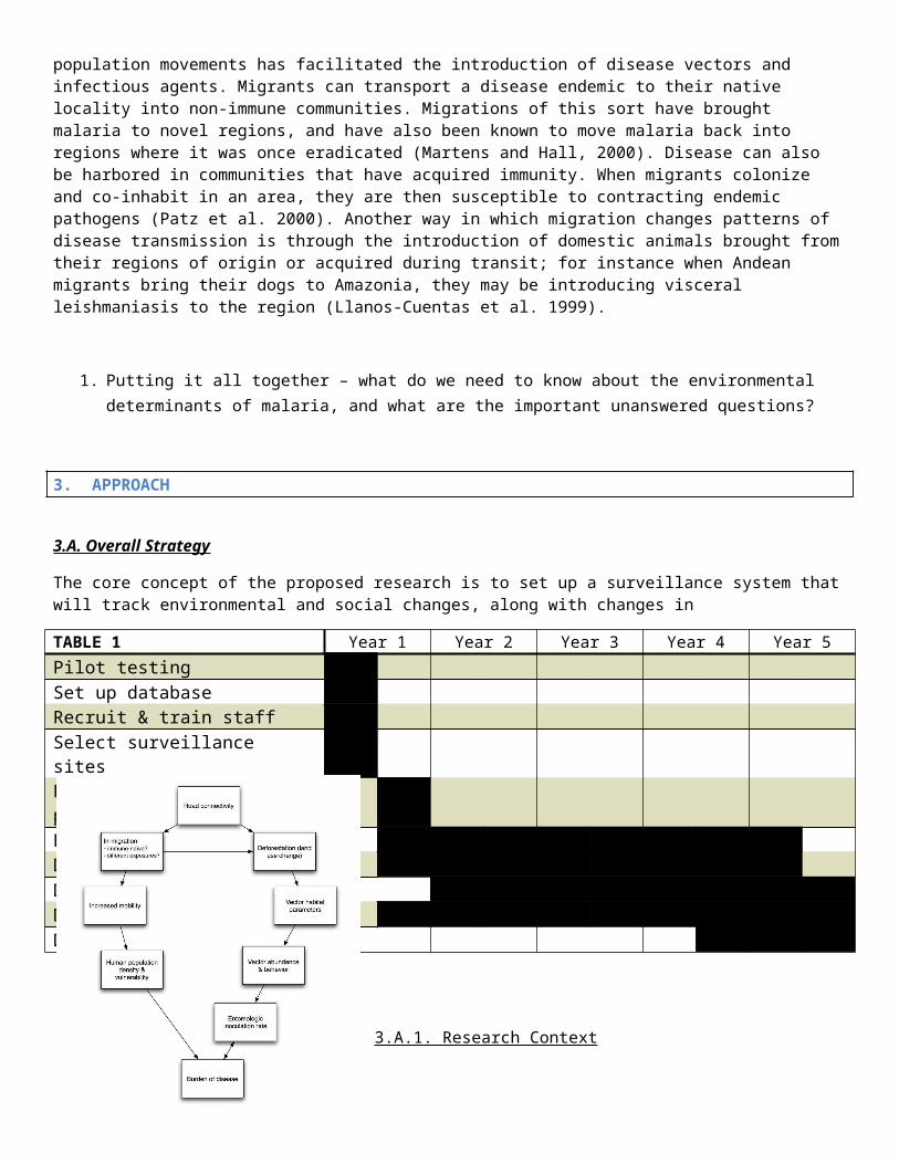
3.A. Overall Strategy
The core concept of the proposed research is to set up a surveillance system that will track environmental and social changes, along with changes in
TABLE 1 Year 1 Year 2 Year 3 Year 4 Year 5Pilot testingSet up databaseRecruit & train staffSelect surveillance sitesRecruit study participantsEnvironmental variablesDemographic variablesDisease variablesData managementData analysis
3.A.1. Research Context
As part of a continent-wide initiative that has as its stated goal to promote the development of an integrated and more efficient infrastructure in 12 South American countries, the Initiative for the Integration of the Regional Infrastructure of South America (IIRSA), launched in 2000, has a planned portfolio of ten “axes of integration” each of which includes scores of infrastructural projects (Dourojeanni 2006, Killeen 2007). One of IIRSA’s current major foci is the Inter-Oceanic Highway, an effort that encompasses several dozen projects including, as mentioned above, the paving and other improvements to roads and bridges that link Brazil with Peru and Bolivia. The Inter-Oceanic will connect of paved roads in the Brazilian State of Acre with roads in the Peruvian region of Madre de Dios. The improvement of these highway links and the building of multiple new bridges is greatly facilitating the movement of goods from Brazil to the Pacific coast of the continent and eventually to ports in Asia. It is also
facilitating the circulation of people and goods within
southwestern Amazonia, as well as between Amazonia and the heavily populated Andean highlands and coastal cities of Peru. In Peru, it is also expected to contribute to the development of a poor and little developed regions of Madre de Dios and Upper Purus (Dourojeanni 2006). The road work in Peru that consisted in upgrading, including paving of approximately 2,586 km of roadways and bridges between the town of Iñapari in Madre de Dios, on the border with Brazil, and the Pacific ports of Ilo, Matarani and San Juan de Marcona has ended a couple of months ago this year (Fig. ???).
Figure 2: Map of study region
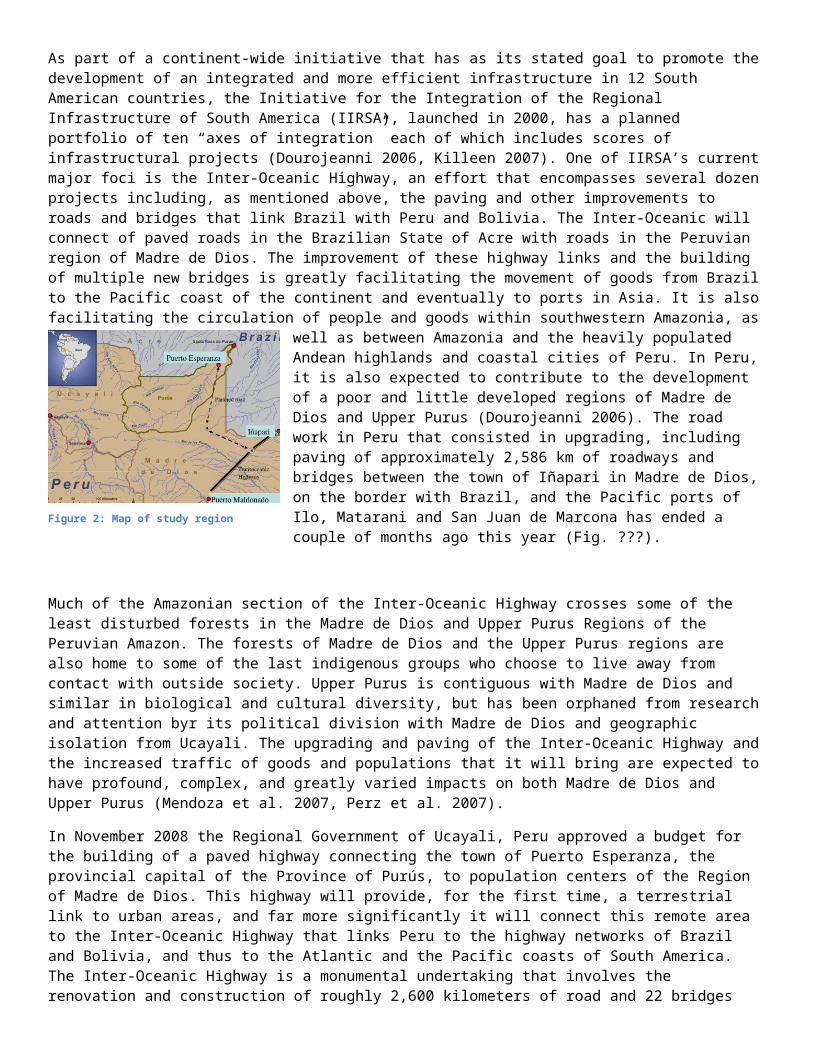
Much of the Amazonian section of the Inter-Oceanic Highway crosses some of the least disturbed forests in the Madre de Dios and Upper Purus Regions of the Peruvian Amazon. The forests of Madre de Dios and the Upper Purus regions are also home to some of the last indigenous groups who choose to live away from contact with outside society. Upper Purus is contiguous with Madre de Dios and similar in biological and cultural diversity, but has been orphaned from research and attention byr its political division with Madre de Dios and geographic isolation from Ucayali. The upgrading and paving of the Inter-Oceanic Highway and the increased traffic of goods and populations that it will bring are expected to have profound, complex, and greatly varied impacts on both Madre de Dios and Upper Purus (Mendoza et al. 2007, Perz et al. 2007).
In November 2008 the Regional Government of Ucayali, Peru approved a budget for the building of a paved highway connecting the town of Puerto Esperanza, the provincial capital of the Province of Purus, to population centers of the Region of Madre de Dios. This highway will provide, for the first time, a terrestrial link to urban areas, and far more significantly it will connect this remote area to the Inter-Oceanic Highway that links Peru to the highway networks of Brazil and Bolivia, and thus to the Atlantic and the Pacific coasts of South America. The Inter-Oceanic Highway is a monumental undertaking that involves the renovation and construction of roughly 2,600 kilometers of road and 22 bridges and is scheduled for completion in 2009. The construction of the Purus road will commence within two years. The Ucayali Regional Government is set to commission impact statements and to take bids on highway construction. The Purus plan has aroused opposition as well as support from many quarters; there is virtually no doubt now that highway construction will commence sometime in 2010 (A. Ruiz, pers. comm.).
3.A.2. A network of surveillance sites
We propose to create a system of 9 surveillance sites centered on human settlements that capture situations ranging from complete isolation to completely connected by road. The basic idea is to look at differences-in-differences (i.e., compare the time trend in the treatment sites to the time trend in the control sites).
Three sites in the Transoceanic influence zone Three sites in the Purus road zone of potential influence Three control sites
We will use remote sensing methods to identify suitable candidates.
3.A.3. Aim 1: Ecological and entomological parameters to measure
The primary aim of the ecological monitoring will be to trace the relationships between the following factors:
A. land use, B. land cover C. vector habitat D. vector abundance E. vector behaviorF. entomologic inoculation rate
We need to define exactly what measures will take place in the field – what are the key parameters that we need to measure? E.g., A, B and C can be measured with appropriate plots and transects. Vector biting behavior is a key parameter here.
To date, studies on the socio-environmental impact of road building suggest that demographic and land-use changes have combined to create and diversify habitats for mosquitoes and other vectors of infectious diseases in Western and other regions of Amazonia (Patz et al. 2000). Experts report that occupation of areas along roads leads to complex changes in vector breeding sites and behavior (Vittor et al. 2006). Some effects of these changes on the distribution, dispersal, and reproduction of malaria mosquito vectors have been documented along roads in Western Amazonia (Vittor et al. 2006, Castro et al. 2006). We aim to look at the complex interactions between the diversification of mosquito microhabitats and behavior and the Plasmodium

parasite. Is the increase of habitat leading to an increase in mosquito vector populations and facilitating the transmission of malaria along the Transoceanic Highway?
Experts have suggested that the landscape transformation that ensues road construction, coupled with the human preference for unpolluted, clear water, fosters the breeding sites of malaria vectors such as Anopheles darlingi and marajoara (Conn et al. 2002). The Transoceanic Highway has the potential to increase malaria by combining features conducive to greater transmission such as forest clearing, hydrological shifts, and development of settlements without any sanitation. We believe that spread of settlements make ideal breeding habitats for Anopheles darlingi in the region along the Transoceanic Highway. This species is the most important vector transmitting malaria in Amazon because it is highly anthropophilic, readily enters homes to feed, has a wide range of feeding times, and is susceptible to both P. vivax and P. falciparum (Fachin and Fernandez 2002, Flores-Mendoza et al. 2004). Based on these and other findings, we expect events of the population explosion of Anopheles darlingi, that will result in localized epidemic events of malaria as secondary roads are built along the Transoceanic Highway.
We proposed to implement a monitoring system that based on the results of monitoring systems tested by Cayetano Heredia (Gamboa et al. 2008, Branch et al. 2005), the US Naval Medical Research Center Detachment that is based in the Peruvian Amazon (NAMRCD) and the MOH. Through the infrastructure established by researchers from the above institutions, we will gain access to a historical database of localized mosquito captures including both light traps, e.g., Schoeler et al. (2004) and baited samples Vittor et al. (2006). We will conduct our own baited mosquito sampling in selected villages, concurrent with the malaria census in consenting households. Sampling will begin at dusk and continue until midnight, with mosquito collectors rotating among sites to eliminate biases from individual variation (Vittor et al. 2006). Mosquito collections will be identified using the morphological key for Amazonian Brazil (Consoli and Lourenço-de-Oliveira 1994).
The members of the team at Cayetano Heredia will develop a system for quantifying mosquito infection rates (Gamboa et al. 2008). We will use the laboratory facilities at Cayetano Heredia to test mosquitoes for P. falciparum and P. vivax infection using ELISA. ELISA allows rapid and accurate determination of malarial sporozoite loads in mosquitoes by using monoclonal antibodies to identify proteins on the sporozoite surface (de Arruda et al. 2004). Determination of infection rate in sampled mosquitoes will help us understand transmission dynamics within and between households. This information will determine what species serve as primary vectors in the selected sites under study. While Anopheles darlingi is clearly linked to the transmission of malaria (Vittor et al. 2006), vectors such as A. benarrochi contribute to maintaining low-level transmission throughout the region (Flores-Mendoza et al. 2004). By controlling for the composition of vector communities and infection rate in the selected sites, we will establish the relative importance of household landscaping practices, ranging from house construction to forest clearing, in heightening malaria risk.
We used remote sensing imagery to adapt a standard method for defining a gradient land-use for identifying and describing the microhabitats where mosquito samples will be collected by a well trained field team of Cayetano Heredia that will be under the supervision of D. Gamboa and E. Perez. Gradients of land use are reported to be more practical for understanding the diversification of mosquito habitats and for understanding how road building and changes in demographic and land use patterns affect vector distribution measured and diversity within a defined landscape (Johnson et al. 2008). We will define a land use gradient using percent pervious and impervious surface coverage as a proxy for land use change (Vittor et al. 2008). We will use a composite Landsat Sensor ETM image (2000-2010) of the Transoceanic track between Puerto Maldonado and Iñapari from the Global Land Cover Facility (glcf.umiacs.umd.edu) and process it with RSI Envi 4.2 (ITT Corp., Boulder, CO) using supervised classification to define pervious surface categories including vegetation and water. The classified image will be imported into ArcGIS 9.0 (ESRI, Redlands, CA) and combined with a data layer containing coordinates of collection sites. Sites will be classified into three levels of human influence (settlements, fields and forests). All data on microhabitat will be organized in a GIS database.
The most important insect vectors that will be collected the malaria vectors Anopheles spp. for each selected cell. Other biting insects, e.g., Culex spp., will be collected, quantified and stored, but not studied further. We expect to encounter higher relative abundance Anopheles close to houses and settlements along the selected sites, particularly in agriculture- forest mosaics. Sampling localities in agriculture-forest boundaries and mosaics will be especially important because these areas are where many environmental modifications will occur as road-building advances.
The vector collections will be made using methods described by Perez et al. (1988) and Ogusuku & Perez (2002). These methods are currently being used by the vector surveillance system of the Peruvian Ministry of Health. J. Enrique Perez will lead collections in selected cells using the following methods:
Anopheles spp. and other biting insects will be collected with CDC light traps between the hours of 6 pm and 6 am. With this collection approach, we expect to collect both anthropophilic and non-anthropophilic species, including anthropophilic males.
Well-trained insect collectors working with the Ministry of Health in nearby Puerto Maldonado will collect insect vectors. These collectors will work with four young researchers who have recently completed their theses on disease vectors of the region. The identification of the material will be made at the Entomology laboratory of Instituto de Medicina Tropical Alexander von Humboldt in Lima. The collections will also be preserved and deposited there. Vouchered identification of disease vectors will provide response variables for non-parametric comparisons between cells (e.g., at different phases of road construction), as well as models of insect communities as a function of landscape heterogeneity and forest cover. The presence of disease vectors, their biting rate, and abundance relative to total captures will be response variables in binary (for presence absence) and ordinal (for ranks of biting rates and relative abundances) logistic regressions.
PCR assays will be used to detect and identify Plasmodium spp. in Anopheles mosquitoes (Branch et al. 2005, Perez et al. 2008). Half the vectors collected at each sampling locality will be randomly selected for these assays. Pooled samples of 10 individuals will be used to extract DNA and amplify protein-coding genes of the relevant parasites with published primers (Branch et al. 2005, Perez et al. 2008). Pooling samples reduces cost, while enabling the detection of infection for each sampling locality. PCR assays will be verified by randomly selecting 10% of the positive bands for DNA sequencing. Sequences generated in this project will be deposited in GenBank. Malaria infection rates will be modeled as a function of the size and composition of the people using for each geographic cell. J. Enrique Perez will supervise all disease detection procedures at the molecular laboratory of the Instituto de Medicina Tropica Alexander von Humboldt.
Logistics for implementing ecological/entomological monitoring plan
3.A.4. Aim 2: Social parameters to measure
Communities both along the new highway and in Purus province present several challenges for social and demographic research. The population along the road is extremely mobile with both new settlers and transients predominating in some areas. The 2007 National Census (INEI 2007) showed, for example that the population of Madre de Dios is by several measures Peru's most mobile. For example, only 65% of the total population in all of Madre de Dios' districts had lived in the same district 5 years before, the lowest percentage in the country. Purus has a somewhat lower 74%. In some districts along the new highway only 31% of the 2007 population had been born in the same district. Over 11% of the population of Madre de Dios could be classified as transients, i.e., not living in the district where they were censused; in some districts along the roads transients made up almost a quarter of the total. Purus, on the other hand still shows a much lower 4% of transients. We believe that many of the census data, especially in Madre de Dios seriously underestimate the number of migrants and of transients, especially in the various "pueblos dispersos" and other informal communities that are found along many of the highways new feeder roads. Puerto Maldonado-based personnel Peru's National Institute of Statistics and Informatics (INEI) suggested that since most of these communities had fewer than 150 persons, they were not censused.
Madre de Dios residents, both more older communities and new immigrants, tend to engage in a large number of economic activities, each one of these practiced in various ways and at different scales. Many if not most rural dwellers are, simultaneously or serially, farmers, miners, livestock producers, collectors of Brazil nits, marketers, and wage laborers. Each of these activities may change the susceptibility of the individual and his or her household to malaria.
Basic social and demographic information will be collected at each of the nine sites in the first year, expected to begin in January 2011. Data collection will begin with compilation of all existing demographic,
economic, educational, and health data available at the provincial, district and community levels. Each household in the sample sites will then be visited and interviewed and demographic data on each individual in the household, including age, gender, place of birth, and length of residence will be collected. These basic data will serve as a demographic baseline. Each household will be recensused annually and any new households and individuals will be added to the census as they appear in the site. Special efforts will be made to include transient populations and those residing away from villages and traditional communities, including those engaged in artisanal mining and logging .
Information on resource use and other economic activities will also be gathered through interviews with each adult and economically active individual residing in the research sites. Data that will be gathered will include: principal economic activities, place and time of principal economic activities (with emphasis focused on both seasonal and diurnal variation), size and location of landholdings, and the history of history of land use at this site. These data will then be cross-referenced with those gathered from remotely sensed images. Each household will be reinterviewed every 3 months to capture the great dynamism of economic activities in the research sites.
Data on travel and mobility apart from that done in the course of economic activities will also be gathered through initial interviews and will be updated every three months. All adults will be asked about the destination and duration of any travel outside the site, including travels to the city and to other regions.
We will begin to collect baseline information at each site in the first year, expected to begin on September 2009. As described above, data on social variables will be conducted initially through semi-structured interviews. Data collected will include: place of origin of household heads or landowners, length of residence in the region, size of landholding, and plans for developing the property over the coming 5 years, especially plans to convert large areas to commercial agricultural production. At the FB site, longer histories of land use change will be collected through semi- structured interviews in the first year. Every selected household or landholding will be revisited and re- interviewed every six months to collect data on changes in land use and plans for the ensuing 5 years.
Interviews will focus on: 1) members of households with land holdings overlapping the selected cells, and 2) people who spend time gathering, hunting, logging, fishing, conducting other kinds of labor, or en route to other sites. The first category of users is relevant to managing and modifying the landscape, while the second category is expected to affect the infection rate of vectors (which depends on the continued presence or introduction of infected individuals and/or domestic animals). Users of each cell will be identified through interviews of residents and observation. Land use associated with each cell will be characterized as household-based (smallholder agriculture) or commercial (large-scale agriculture or cattle ranching), and users will be characterized as local or non-local (i.e., recent immigrant arriving as a result of road construction). The expectation is that household-based agriculture will be more closely linked to local people and tend to maintain some forest patches and heterogeneity, whereas immigrants from outside the region will practice commercial agriculture more frequently, leading to complete forest loss and landscape homogeneity. These expectations are based on on-going and as yet unpublished field research in the Ucayali region by Pinedo-Vasquez and Padoch. Household-based or commercial land use will be used as one categorical independent variable in models of land cover change from forest to non- forest. In cases where more than one type of agriculture is present in the cell, we will score the cell as corresponding to the highest percent of agriculture in the sample (for example if 30% of land use is commercial and 15% is non-commercial, the cell will be scored as commercial.) The total number of users and proportion of users (percent) of a cell will be used as independent variables to analyze both the change in land cover and the infection rate of vectors.
3.A.5. Aim 3: Health parameters to measure
Active case finding in the surveillance sites, with fieldworkers based out of existing health posts. This will entail trained field workers visiting a sample of households every week and using a questionnaire to detect cases. Fieldworkers will refer suspected cases to a clinic for serological confirmation. We need to specify exactly what kind of diagnostics we will use, and what supply costs they imply.
Additional immunological assay to assess immunity to lowland diseases? Need background information on prevalence of Malaria.
Need to address what will occur when a case is found. Currently, the Peruvian national government provides free care.
3.A.6. Data management plan
The proposed research will create a large volume of data. We will adopt the following practices to ensure data quality, security.
In year 1, we will engage a database experience with experience with complex data structures from remote field sites to design a relational database and data handling procedures. This outside expert will perform annual audits to ensure that appropriate procedures are being followed.
Reliance on electronic data entry in the field A full time position at Cayetano Heredia for a database manager.
3.A.7. Data analysis plan
Analysis will begin with examination of the distributions of all variables to identify potential outliers and to explore appropriate transformation of variables. Descriptive statistics will be calculated for all variables. Bivariate analyses will be used to explore the association between outcome measures and all control variables. We will first inspect bivariate scatter plots for patterns of association that may suggest proper modeling and data transformations. The difference between continuous and categorical measures of exposure will be explored using box-plots by exposure categories. Chi-square test will be used to test for association between categorical variables. T-tests will be used to detect differences in continuous variables between categories of a binary variable if distributions of the (transformed) continuous variables are approximately normal; otherwise non-parametric test such as Wilcoxon rank sum test will be used. Similarly, analysis of variance will be used to compare three or more groups for continuous variables with approximate normal distribution. Otherwise non-parametric Kruskal-Wallis test will be used. Correlation analysis will be conducted to examine the relationships between quantitative variables.
To test the effect of
3.A.8. Project management
Drs. Miguel Pinedo-Vasquez, Darby Jack, Enrique Perez, and Dionicia Gamboa will comprise an executive committee, responsible for final decisions on all major issues of study design and methodology. They will be joined in bi-weekly project conference calls by co-investigators, including TBN Field Coordinator/Project Manager. In addition to these bi-weekly teleconferences, the project team will hold two in-person meetings per year, one in Peru and one in New York.
Dr. Pinedo-Vasquez will have overall responsibility for scientific and fiscal management. Dr. Darby Jack will have final responsibility for demographic and other social science aspects of the
project. Dr. Enrique Perez will have final responsibility for ecological and entomological monitoring. Dr. Dionicia Gamboa will have final responsibility for health monitoring.
Field staff training will take place in the first six months of year 1, and will involve all members of the research team, with responsibilities divided as above. Recertification of staff will occur at six-month intervals thereafter through the midpoint of year 5.

3.B. Potential problems and alternative strategies
* challenges of operating in remote regions
* malaria
3.C. Strategy for addressing risky aspects of our approach
3.D. Hazards to personnel
References
1. Oliveira-Ferreira J, Lacerda MV, Brasil P, et al. Malaria in Brazil: an overview. Malar J. 2010;9(1):115.
2. WHO. World Malaria Report 2009. Geneva, Switzerland: WHO
3. Aramburu Guarda J, Ramal Asayag C, Witzig R. Malaria reemergence in the Peruvian Amazon region. Emerging Infect. Dis. 1999;5(2):209-215.
4. Pfaff AS. What Drives Deforestation in the Brazilian Amazon?:: Evidence from Satellite and Socioeconomic Data. Journal of Environmental Economics and Management. 1999;37(1):26–43.
5. M\äki S, Kalliola R, Vuorinen K. Road construction in the Peruvian Amazon: process, causes and consequences. Environmental Conservation. 2002;28(03):199–214.
6. Soares-Filho BS, Nepstad DC, Curran LM, et al. Modelling conservation in the Amazon basin. Nature. 2006;440(7083):520–523.
7. Laurance WF, Cochrane MA, Bergen S, et al. The future of the Brazilian Amazon. Science(Washington). 2001;291(5503):438–439.
8. Cochrane MA, Laurance WF. Synergisms among fire, land use, and climate change in the Amazon. Journal Information. 2008;37(7).
9. Malhi Y, Arag\ ao LE, Galbraith D, et al. Exploring the likelihood and mechanism of a climate-change-induced dieback of the Amazon rainforest. Proceedings of the National Academy of Sciences. 2009;106(49):20610.
10. Li W, Fu R, Juárez RI, Fernandes K. Observed change of the standardized precipitation index, its potential cause and implications to future climate change in the Amazon region. Philosophical Transactions of the Royal Society B: Biological Sciences. 2008;363(1498):1767.
11. Malhi Y, Roberts JT, Betts RA, et al. Climate change, deforestation, and the fate of the Amazon. Science. 2008;319(5860):169.
12. Bacon DJ, McCollum AM, Griffing SM, et al. Dynamics of malaria drug resistance patterns in the Amazon basin region following changes in Peruvian national treatment policy for uncomplicated malaria. Antimicrobial
agents and chemotherapy. 2009;53(5):2042.