Embed Size (px)
Citation preview
RESEARCH Open Access
Spatial patterns of malaria in a land reformcolonization project, Juruena municipality,Mato Grosso, BrazilElaine Cristina de Oliveira1, Emerson Soares dos Santos2, Peter Zeilhofer3, Reinaldo Souza-Santos4 andMarina Atanaka-Santos5*
Abstract
Background: In Brazil, 99% of malaria cases are concentrated in the Amazon, and malaria’s spatial distribution iscommonly associated with socio-environmental conditions on a fine landscape scale. In this study, the spatialpatterns of malaria and its determinants in a rural settlement of the Brazilian agricultural reform programme called“Vale do Amanhecer” in the northern Mato Grosso state were analysed.
Methods: In a fine-scaled, exploratory ecological study, geocoded notification forms corresponding to malariacases from 2005 were compared with spectral indices, such as the Normalized Difference Vegetation Index (NDVI)and the third component of the Tasseled Cap Transformation (TC_3) and thematic layers, derived from the visualinterpretation of multispectral TM-Landsat 5 imagery and the application of GIS distance operators.
Results: Of a total of 336 malaria cases, 102 (30.36%) were caused by Plasmodium falciparum and 174 (51.79%) byPlasmodium vivax. Of all the cases, 37.6% (133 cases) were from residents of a unique road. In total, 276 cases werereported for the southern part of the settlement, where the population density is higher, with notification rateshigher than 10 cases per household. The local landscape mostly consists of open areas (38.79 km²). Training forestoccupied 27.34 km² and midsize vegetation 7.01 km². Most domiciles with more than five notified malaria caseswere located near areas with high NDVI values. Most domiciles (41.78%) and malaria cases (44.94%) wereconcentrated in areas with intermediate values of the TC_3, a spectral index representing surface and vegetationhumidity.
Conclusions: Environmental factors and their alteration are associated with the occurrence and spatial distributionof malaria cases in rural settlements.
BackgroundIn Brazil, and more specifically in the state of MatoGrosso, the population in rural land reform settlementsand occupations increased dramatically in the 1980s and1990s. Additionally, thousands of people migrated to thenorthern regions of the state during this period,attracted by the discovery of gold there. Unregulatedmining became a principal economic activity, increasingthe occupation of the region [1] and leading to intense
land use and dramatic environmental transformations inthe Amazon landscapes [2].The informal gold extraction techniques that predomi-
nate in these mining areas favor the creation of environ-ments appropriate for malaria vector reproduction, withnumerous bodies of standing water and small areas withhigh population densities [3].As a consequence of the complex network of factors
involved in the transmission of malaria, one techniquefor the analysis of the disease has utilized GeographicalInformation Systems (GIS). GIS allow information fromdifferent sources to be stored and integrated, enablingan analysis of the interactions between relevant variablesin their spatio-temporal context, the development and
* Correspondence: [email protected] of Public Health, Federal University of Mato Grosso, Av. FernandoCorrêa, Cuiabá, Mato Grosso State, 78.060-900, BrazilFull list of author information is available at the end of the article
de Oliveira et al. Malaria Journal 2011, 10:177http://www.malariajournal.com/content/10/1/177
© 2011 de Oliveira et al; licensee BioMed Central Ltd. This is an Open Access article distributed under the terms of the CreativeCommons Attribution License (http://creativecommons.org/licenses/by/2.0), which permits unrestricted use, distribution, andreproduction in any medium, provided the original work is properly cited.

testing of hypotheses, supervision and evaluation ofinterventions and the construction of predictive modelsas part of preventive operations [4-6].As the spatial patterns of malaria in a territory reflect
complex interactions between parasites, vectors, andhuman hosts, studies of the influences of environmentalfactors on malaria allow the simulation of epidemiologi-cal risk situations as a tool for health care decision-mak-ing and the definition of priority actions for malariacontrol [7]. Many large-scale studies exist, as shown byEISEN and WRIGHT [8], but studies at different spatialscales are required to understand fully the relationshipsbetween landscape features, parasite distribution, andmalaria infection. As the risk of malaria infection isrelated to multiple factors, the interactions betweenwhich have rarely been explored at local scales in thesouthern Amazon, the present study identifies and ana-lyses the influences of multiple socio-environmentalcharacteristics on the spatial distribution of malariacases in the “Vale do Amanhecer” settlement of the Bra-zilian land reform programme in northern Mato Grosso.
MethodsStudy areaThe “Vale do Amanhecer” settlement is located innorthern Mato Grosso, about 6.2 km from the city ofJuruena, at 10°22’53.84” S latitude and 58°25’27.35” Wlongitude. Founded by the Federal Institute of Coloniza-tion and Land Reform [9] in 1998, the settlement com-prises 14,400 ha. One half of the area was designated forsettlement by 250 families, whereas the other was setaside as a permanent protection area. Each land unit hasan area of about 26 ha, and units are distributed alongprojected, linear roads numbered from 01 to 14(Figure 1). The average demographic density is 10.41inhabitants/km2. The main economic activities of thesettlement are cattle farming and agricultural subsis-tence and, mainly along the streams, some informal goldmining.
Data acquisition and analysisEpidemiological dataA total of 585 notification forms from the EpidemiologicSurveillance Information System [10] from the year 2005were obtained from the municipal health care adminis-tration. All registries were cross-checked and georefer-enced in a TerraView 3.1.4 [11] spatial database.Spatial data layersSpatial data sets were elaborated using TerraView 3.1.4(INPE), ArcGIS 9.2 (ESRI), SPRING 4.3 (INPE) andENVI 4.1 (RSI) software. A multispectral TM-Landsat 5image from 25-06-2005 (WRS 229/67) was obtainedfrom the Instituto Nacional de Pesquisas Espaciais(INPE) and georeferenced. A land-use map was created
through the visual interpretation of a #3#4#5 color com-posite, where the following three thematic classes weredifferentiated: (a) Forests, (b) Agricultural area, and (c)Secondary vegetation.Two spectral indices were derived from the Landsat
TM imagery: the Normalized Difference VegetationIndex (NDVI), a widely used measure of the amount ofgreen biomass, and the third component of the TasseledCap Transformation [12], an index representing thehumidity of the first reflectance layer (vegetation coveror soil surface). The NDVI was calculated in theSPRING 4.3 software by the combination of the red (#3)and near infrared (#4) bands ([#3-#4]/[#3+#4]) scaledinto 256 grey levels. Then, three classes were defined:low (0 to 100), intermediate (101 to 200) and high (>200). The Tasseled Cap Transformation (hereafterTC_3) was performed by the respective module in ENVI4.1 and then differentiated into the following classes:low (0 to 76.5), intermediate (76.6 to 165.8) and high (>165.8).The following distance layers were created using the
buffer command of the TerraView 3.1.4 software: Onefor the distance to potential procreation habitats, withthree 100-m zones (100, 200 and 300 m); one for thedistance to streams, with 100-m zones between 100 mand 1,500 m; and one for the distance to mining areas,in 300-m zones from 300 m to 6,900 m. These valueswere selected considering knowledge of the feeding andreproduction habits of Anopheles species, which can flyfurther than 1.5 km but generally remain near theirreproductive habitat [13].This study is part of the “Malaria spatial analysis in
rural land reform settlements project” and was approvedby the Julio Muller Hospital Ethics Committee.
ResultsIn 2005, the settlement was occupied by 718 inhabitants,394 (54.87%) of them male and 324 (45.13%) female. Atotal of 359 malaria cases were reported, 23 of whichwere excluded from the sample because no residenceaddress was given and 18 because the patient’s residencewas located outside of the settlement.From the remaining total of 336 cases, 133 positive
smears were from residents of Road 08, which corre-sponds to 37.60% of all reported cases. For Roads 13and 05, 124 (35.10%) and 58 (16.40%) malaria caseswere reported, respectively (Figure 2).Cases were concentrated in the southern part of the
settlement, where 276 cases were reported, often withmore than 10 cases per domicile. In this area, 102 cases(30.36%) were caused by Plasmodium falciparum and174 (51.79%) by Plasmodium vivax. The northern partof the settlement presented 60 cases, and most domi-ciles reported fewer than 10 cases per domicile. Of these
de Oliveira et al. Malaria Journal 2011, 10:177http://www.malariajournal.com/content/10/1/177
Page 2 of 9

cases, 16 (4.76%) were caused by P. falciparum and 44(13.09%) by P. vivax.The visual interpretation of the Landsat TM imagery
showed that 38.79 km² of the settlement’s land wasdeforested, including terrains used for housing, pasturesand agriculture. Forest reminiscents occupied 27.34 km²and secondary vegetation 7.01 km² (Figure 3).The concentration of malaria cases in the southern
part of the settlement coincides with the predominanceof deforested areas there and its proximity to mostmining areas. As expected, 154 (75.86%) of the 203domiciles (200 in the settlement proper and 3 in thepermanent protection area) were located in open areas,which are generally characterized by low NDVI values(from 0 to 100). This result documents the intense landtransformation process initiated with the occupation in2000, which has included the transformation of naturalvegetation into pastures, the opening of mines and theinstallation of mining equipment since 2002. Residentsin this area presented 239 (71.13%) malaria cases, withan average of 1.56 per domicile (Table 1).Whereas this area of the settlement, where the popu-
lation density is highest, reported the majority of the
malaria cases in terms of absolute numbers, the highestinfection rates occurred in areas with denser vegetation.Domiciles located within or near the forested permanentprotection areas with high NDVI values (> 200) reported2.8 cases per domicile; the domiciles with more thanfive reported cases are located in areas of high NDVIvalues as well, mainly near the stream network (Figure4).In absolute terms, the highest numbers of domiciles
(41.78%) and malaria cases (44.94%) were located inareas with intermediate values of TC3. Humid surfaceswith high values of TC_3 occurred mainly in denselyvegetated areas and near the stream network. The aver-age number of malaria cases per domicile in these areas(1.85) is slightly higher than that in areas with inter-mediate TC_3 values (1.82). The number of cases perdomiciles is much lower (1.30 cases per domicile) inareas with low TC_3 values (Figure 5).Domiciles reporting malaria cases were observed
across the whole range of distances from the streamnetwork. Most malaria cases, however, occurred in dom-iciles up to 900 m from streams. Domiciles with morethan 15 cases were concentrated even closer to the
Figure 1 Study area.
de Oliveira et al. Malaria Journal 2011, 10:177http://www.malariajournal.com/content/10/1/177
Page 3 of 9

hydrographic network, at a maximum distance of 300metres (Figure 6).All domiciles with malaria cases were located less than
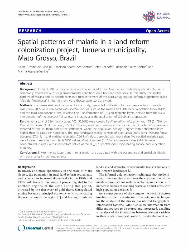
1.6 km from the nearest potential reproductive habitatof Anopheles species, including watercourses, standingwater, springs, wells and small dam reservoirs. Casesdecreased on a gradient with increasing distance fromthese locations (Figure 7).Cases were also negatively related to the distance from
mining areas. The 70 domiciles (34.48%) located lessthan 1.2 km from a mining area accounted for 237malaria cases (70.5%), with an average of 3.38 cases perdomicile. All domiciles with more than five cases werelocated at most 2.1 km from the nearest mining area,whereas all domiciles with fewer cases (between one andfive) were at least 1.2 km from the nearest mining area(Figure 8).
DiscussionIn the Vale do Amanhecer settlement, malaria washighly prevalent in 2005, with about 47% of the settle-ment’s 718 inhabitants affected by the disease. There-fore, the study area provides a clear example of the focal
nature of malaria occurrence in the Amazon region,where malaria is often concentrated in settlements andareas of mining activity. The average prevalence in theJuruena municipality is about five times lower than inVale do Amanhecer.The comparison of the spatial pattern of malaria
occurrence with geographic layers representing vegeta-tion distribution and distances to watercourses andmining areas showed variable findings in this fine-scaleepidemiological study.Numerous studies have shown that malaria infection
is influenced by environmental factors, such as tempera-ture, precipitation, humidity and altitude. In tropicalregions, such as the Amazon region, year-round hightemperatures and precipitation favor malaria transmis-sion [14-16,2]. Most studies have been large-scale sur-veys on a regional or country scale [14,17,7]. Asvariations at these scales can be governed by otherexternal factors, local-scale studies, such as those carriedout within a single settlement [18], are crucial forunderstanding the driving factors of malaria transmis-sion and for community-based health planning [19]. Atthis scale, transmission rates are not only governed by
Figure 2 Distribution of malaria cases.
de Oliveira et al. Malaria Journal 2011, 10:177http://www.malariajournal.com/content/10/1/177
Page 4 of 9

demographic or ecological factors but are alsoinfluenced by the social and cultural contexts of localpopulations [20].In the studied settlement, relationships between the
environment and spatial patterns of malaria occurrencewere observed. For risk evaluation, the combination ofland use and vegetation cover must be considered. Morecases are reported in deforested areas with low NDVIand TC_3 values, but this is exclusively due to thehigher local population density and population fluxes.The highest rates of malaria per domicile were reportedwithin or near forest reminiscent with high spectralindices. Additionally, at a local scale, it must be consid-ered that infection did not necessarily take place in thedomicile.Vegetation cover plays an important role in the biolo-
gical cycles of vectors and infectious agents, particularlyif other environmental conditions, such as precipitation,temperature or humidity, are altered [21,22]. This altera-tion explains the elevated incidence of malaria cases indomiciles inside or near forested areas with high valuesof NDVI, which may be characterized by higher vector
Figure 3 Land use and malaria cases.
Table 1 Absolute (AF) and relative frequencies (RF),average (Av) and standard deviation (SD) of Land-use,NDVI and TC_3
Variables Classes AF RF (%) AF1 RF1 Av SD N.D2
Land-use Agriculturalarea
239 73.31 239 73.31 1.49 2.84 160
Secondaryvegetation
17 5.21 256 78.53 2.13 4.85 8
Forest 70 21.47 326 100.00 1.71 2.74 41
Total 326 100.00 - - 1.56 2.90 209
NDVI Low 209 64.11 209 64.11 1.49 2.78 140
Intermediate 64 19.63 273 83.74 1.28 2.96 50
High 53 16.26 326 100.00 2.79 3.44 19
Total 326 100.00 - - 1.56 2.90 209
TC_3 Low 78 23.93 78 23.93 1.24 2.11 63
Intermediate 151 46.32 229 70.25 1.70 3.44 89
High 97 29.75 326 100.00 1.70 2.75 57
Total 326 100.00 - - 1.56 2.90 2091 - Accumulated2 - Number of domiciles
de Oliveira et al. Malaria Journal 2011, 10:177http://www.malariajournal.com/content/10/1/177
Page 5 of 9

Figure 4 Vegetation index (NDVI) and malaria cases.
Figure 5 Vegetation and soil humidity index (TC_3) and malaria case distribution.
de Oliveira et al. Malaria Journal 2011, 10:177http://www.malariajournal.com/content/10/1/177
Page 6 of 9

densities. The low absolute numbers of cases in theseareas are caused by their low housing density (18.2% ofall domiciles) and low population flux.High TC_3 values were observed inside forested areas
and areas with dense vegetation succession. The highestaverage case rate per domicile (1.82) was found in areaswith high TC_3 values, possibly due to the presence ofhumid areas favoring vector proliferation. These areasmainly coincide with buffer zones near streams, explain-ing the concentration of cases in domiciles less than 1km from the hydrographic network, which is densethroughout the settlement.High malaria infection rates in the settlement are sup-
posedly related to the changes in land use carried outby a population that originated partially from non-ende-mic regions. FERREIRA [23] identified a malaria preva-lence of 56.0% in individuals who migrated to thesettlement from non-endemic regions, who have aninfection probability 2.9 times higher than individualsfrom endemic regions, a difference supposedly causedby their low immunity and lack of knowledge aboutmeasures to protect against the disease [16,24].
Studies such as [7,21,25,26] have pointed out that thedistribution and dynamics of malaria cases are related tothe phase of land occupation. Deforestation, aggregatedwith an influx of migrants, frequently produces newreproduction and principal feeding habitats, favoring theoccurrence of epidemics in communities with popula-tions characterized by high mobility, low immunity andlow risk perception [24,3].Infection rates are also thought to be elevated due to
the lack of an adequate sanitation infrastructure, whichmotivates inhabitants to construct their housing nearstreams to facilitate domestic tasks and personalhygiene. Vasconcelos et al [7] described a similar spatialpattern of domicile distribution in the Jacundá munici-pality, attributing elevated malaria infection rates to thislack of sanitation infrastructure.The observed malaria infection rates can be explained
by the great number of potential reproduction habitatsand mining areas in the settlement; cases are highlyconcentrated near these areas, which favor the survivaland circulation of the main vector, Anopheles darlingi[7]. Close relationships between mining activities and
Figure 6 Distance to nearest stream (buffers) and malaria cases.
de Oliveira et al. Malaria Journal 2011, 10:177http://www.malariajournal.com/content/10/1/177
Page 7 of 9
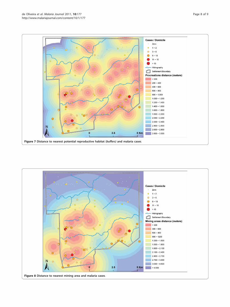
Figure 7 Distance to nearest potential reproductive habitat (buffers) and malaria cases.
Figure 8 Distance to nearest mining area and malaria cases.
de Oliveira et al. Malaria Journal 2011, 10:177http://www.malariajournal.com/content/10/1/177
Page 8 of 9

malaria cases in the Amazon region have also beenreported by Santos et al. [27] and Duarte & Fontes [28].
ConclusionsConfiguration of land use with a mosaic of reminiscentforests and occupied deforested areas, a dense streamnetwork, numerous breeding habitats and mining activ-ity, paired with a mobile population with low immunityand low-risk perception, can explain the high malariaincidence in the studied settlement. Malaria, which isknown to be a focal disease, presents a heterogeneousspatial distribution of cases, even in the current fine-scaled local study. Findings of this study demonstrateincreased exposure to malaria in areas near potentialmosquito vector breeding sites, namely near streamsand mining areas and near more densely-vegetatedareas.
Author details1Epidemiological Surveillance, Health Secretary of Mato Grosso. Rua D,Political Administrative Center, Cuiabá, Mato Grosso State, 78.050-970, Brazil.2Department of Geography, School of Philosophy, Literature and HumanSciences, Av. Prof. Lineu Prestes, 338. Cidade Universitária. University of SãoPaulo, São Paulo, São Paulo State, 05.508-080. Brazil. 3Department ofGeography, Federal University of Mato Grosso, Av. F. Corrêa, Cuiabá, MatoGrosso State, 78.060-900, Brazil. 4Department of Endemic Disease, BrazilianNational School of Public Health, Oswaldo Cruz Foundation. Rua LeopoldoBulhões, 1480, Rio de Janeiro, Rio de Janeiro State, 21.041-210, Brazil.5Institute of Public Health, Federal University of Mato Grosso, Av. FernandoCorrêa, Cuiabá, Mato Grosso State, 78.060-900, Brazil.
Authors’ contributionsECO and ESS contributed to the study design, data acquisition, processingand analysis and manuscript preparation. RSS, MAS, PZ, and ESS participatedin the study conception, scientific coordination and revision of themanuscript. All authors read and approved the final manuscript.
Competing interestsThe authors declare that they have no competing interests.
Received: 1 December 2010 Accepted: 26 June 2011Published: 26 June 2011
References1. Barbieri AF, Sawyer DO: Heterogeneity of malaria prevalence in alluvial
gold mining areas in Northern Mato Grosso State, Brazil. Cadernos deSaúde Pública 2007, 23:2878-2886.
2. Castro MC, Singer BH: Meio ambiente e saúde: metodologia para análiseespacial da ocorrência de malária em projetos de assentamento. RevistaBrasileira de Estudos Populacionais 2007, 24:247-262.
3. Barbieri AF, Sawyer DO: Uso do solo e prevalência da malária em umaregião da Amazônia Brasileira. Caderno de Geografia 2005, 15:9-30.
4. Fotsing JM, Gurgel HC, Zaninetti JM: Estudo de casos de malária emRoraima a partir de técnicas de análise espacial. Anais XIII SimpósioBrasileiro de Sensoriamento Remoto - INPE, Florianópolis; Brasil; 2007,2705-2712.
5. Camara G, Monteiro AMV: Geocomputation techniques for spatialanalysis: are they relevant to health data? Cadernos de Saúde Pública2001, 17:1059-1071.
6. Graham AJ, Atkinson PM, Danson FM: Spatial analysis for epidemiology.Acta Trop 2004, 91:219-225.
7. Vasconcelos CH, Novo EMLM, Donalisio MR: Uso do sensoriamentoremoto para estudar a influência de alterações ambientais na
distribuição da malária na Amazônia brasileira. Cadernos de Saúde Pública2006, 22:517-526.
8. Eisen RJ, Wright NM: Landscape features associated with infection by amalaria parasite (Plasmodium mexicanum) and the importance ofmultiple scale studies. Parasitology 2001, 122:507-513.
9. INCRA (Instituto Nacional de Colonização e Reforma Agrária) Dados doAssentamento de Vale do Amanhecer - Juruena-MT. SuperintendênciaRegional de Mato Grosso, Cuiabá; 2006.
10. Brasil. Ministério da Saúde. Secretaria de Vigilância em Saúde: Sistema deInformação de Vigilância Epidemiológica da Malária.[http://www.saude.gov.br/sivep_malaria], Disponível em.
11. INPE. Instituto Nacional de Pesquisas Espaciais. São Jose dos Campos;[http://www.dgi.inpe.br/CDSR/], Disponível em.
12. Crist EP, Kauth RJ: The Tasseled Cap demystified. Photogrammetric EngRemote Sens 1986, 521:81-86.
13. Borror DJ, Delong DM: Introdução ao Estudo dos Insetos. São Paulo;Edgard Blücher; 1988.
14. Cox JM, Craig DS: Mapping malaria risk in the Highlands of Africa.Mapping Malaria Risk in Africa/Highland Malaria Project (MARA/HIMAL)Technical Report MARA/Durban, London School of Hygiene and TropicalMedicine, London; 1999 [http://www.mara.org.za], Acesso em Outubro/2008. Disponível em.
15. Sawyer DR, Sawyer DO: Malaria on the Amazon frontier: economic andsocial aspects of transmission and control. Belo Horizonte, Cedeplar; 1987.
16. Sawyer DR, Sawyer DO: The malaria transition and the role of socialscience research. Westport: Auburn House; 1992:2:105-122.
17. Kazembe LN, Kleinschmidt I, Holtz TH, Sharp BL: Spatial analysis andmapping of malaria risk in Malawi using point-referenced prevalence ofinfection data. Int J Health Geographics 2006, 5:41-49.
18. Jannuzzi PM: Projeções populacionais para pequenas áreas: método eaplicações. Rio de Janeiro: Escola Nacional de Ciências Estatísticas; 2006.
19. Yazoumé Yé, Hoshen M, Kyobutungi C, Louis VR, Sauerborn R: Local scaleprediction of Plasmodium falciparum malaria transmission in an endemicregion using temperature and rainfall. Global Health Action 2009, 2:10.
20. Mota EGF: Fatores determinantes da situação da malária na Amazônia.Revista da Sociedade Brasileira de Medicina Tropical 1992, 25(suppl 2):13-22.
21. Correia VRM, Monteiro AMV, Carvalho MS, Werneck GL: Uma aplicação dosensoriamento remoto para a investigação de endemias urbanas.Caderno de Saúde Pública 2007, 23:1015-1028.
22. Forattini OP: Culicidologia Médica. São Paulo: Edusp; 20022.23. Ferreira IM: Fatores associados à ocorrência da malária em área de
assentamento, município de Juruena/MT [dissertação de mestrado].Cuiabá: Instituto de Saúde Coletiva da Universidade Federal de MatoGrosso; 2007.
24. Confalonieri UEC: Saúde na Amazônia: um modelo conceitual para aanálise de paisagens e doenças. Estudos Avançados 2005, 19:221-236.
25. Rodrigues AF, Escobar AL, Souza-Santos R: Análise espacial edeterminação de áreas para o controle da malária no Estado deRondônia. Revista da Sociedade Brasileira de Medicina Tropical 2008,41:55-64.
26. Souza-Santos R: Distribuição Sazonal de vetores da malária emMachadinho d’Oeste, Rondônia, Região Amazônica, Brasil. Cadernos deSaúde Pública 2002, 18:1813-1818.
27. Santos VR, Yokoo EM, Souza-Santos R, Atanaka-Santos M: Fatoressocioambientais associados à distribuição espacial de malária noassentamento Vale do Amanhecer, Município de Juruena, Estado deMato Grosso, 2005. Revista da Sociedade Brasileira de Medicina Tropical2009, 42:47-53.
28. Duarte EC, Fontes CJF: Associação entre a produção anual de ouro emgarimpo e incidência de malária em Mato Grosso-Brasil, 1995-1996.Revista Sociedade Brasileira de Medicina Tropical 2002, 35:665-668.
doi:10.1186/1475-2875-10-177Cite this article as: de Oliveira et al.: Spatial patterns of malaria in a landreform colonization project, Juruena municipality, Mato Grosso, Brazil.Malaria Journal 2011 10:177.
de Oliveira et al. Malaria Journal 2011, 10:177http://www.malariajournal.com/content/10/1/177
Page 9 of 9