Embed Size (px)
Citation preview

Chen Environmental Systems Research 2014, 3:13http://www.environmentalsystemsresearch.com/content/3/1/13
RESEARCH Open Access
GIS-based multi-criteria analysis for land usesuitability assessment in City of ReginaJiapei Chen
Abstract
Background: Land use suitability assessment is a key factor in any urban and suburban planning anddecision-making processes. The assessment is evaluated by a series of criteria involving socio-economic needs. Todeal with the conflicting, disproportionate and multiple criteria, land usage will be characterized with respect to thepreferences and importance. Meanwhile, many spatial decision problems can be typically analyzed and interpretedvisually by applying GIS for mapping and analysis. Accordingly, this study is to introduce the Multi-criteria decisionanalysis into the land use suitability analysis along with the existing perspective evolving the role of GIS.
Results: For case study, it is the first time to conduct the identification of the current land use situations in City ofRegina by using GIS, combined with multi-criteria analysis ideology for existing condition analysis with three criteriareferring to social and economic factors. Finally, the study identified five suitability levels, which has revealed thetrends, challenges and prospects of land use analysis for urban extension in City of Regina.
Conclusion: Comparing the simulated land use suitable classes to the existing land use pattern, difference andoptionality have been presented. The results are providing valuable information for the urban extension for policyand decision makers. To improve the accuracy and the reliability of the real-world case study, criteria selection andweight assignments ranks the first place. The integrated use of data analysis and Multi-criteria Decision Analysisapproach, in a GIS context, resulted in a visible assessment of current land use in Regina.
Keywords: Land use suitability; Multi-criteria decision analysis; GIS; Urban extension; Regina
BackgroundDue to the increasing population and economic growth,human activities have continuous impacts on land use.Those impacts might lead to a series complexities towardenvironment and land resources development (Huang andXia 2001). Issues related to population and land use com-petition has emphasized the need for more effective landuse planning and policies. In Canada, in particular, thepopulation has been projected to be 47.7 million by 2036and 63.8 million by 2061, in comparison to 33.7 millionin 2009. This pressure of the population will increasethe requirement of land use enormously. Land use suit-ability assessment is to afford a reasonable and sustainablemanner for land resource development. Meanwhile, thegrowing demand for urbanization, land resources used fora variety of purpose will interact and compete with each
Correspondence: [email protected] of Engineering and Applied Science, University of Regina, S4S 0A2Regina, SK, Canada
© 2014 Chen; licensee Springer. This is an OpeAttribution License (http://creativecommons.orin any medium, provided the original work is p
other. Rational and sustainable decision support based onthe land use suitability assessment is an issue of great con-cern to governments and land users. Thus, an effectiveway to assess suitability of the current land use and pro-vide policy support to the future land use is desired.Previously, various methods of spatial analysis for land
use are commonly used in the suitability assessmentstudies. The problem of land use suitability assessmenthave often been tackled using multi-criteria decision ana-lysis (MCDA) since 1980s (Antoine et al. 1997, Collinset al. 2001, Kiker et al. 2005, Sharifi et al. 2006, Kunwaret al. 2010). Cheng et. al., has reported an integratedMCDA linear programming approach to support selectionof an optimal landfill site (Cheng et al. 2003). To createvisualized suitability map for users and decision makers,the integration of MCDA and GIS has been widely pro-moted for solving spatial problems in urban assessmentand planning (Phua and Minowa 2005). (Malczewski
n Access article distributed under the terms of the Creative Commonsg/licenses/by/2.0), which permits unrestricted use, distribution, and reproductionroperly credited.

Collection and collation of dataLand use PopulationAverage incomeEmployment
Define land use categories
Human activities
Multi-criteria evaluationComputation of weights of factors
Establishment of spatial database
Policy analysis and literature review
Criteria and Standards Determination
GIS-based Land-use Suitability Assessment
Overlay
Figure 1 Flowchart of the study.
Chen Environmental Systems Research 2014, 3:13 Page 2 of 10http://www.environmentalsystemsresearch.com/content/3/1/13
2006) conducted a survey of literature of the GIS-basedMulti-criteria analysis from 1990 to 2004. There hasbeen a substantial acceleration in the number of theGIS-MCDA articles published in this field. Joerin et al.(2001) put forward an outranking multi-criteria analysismethod and output a set of land use suitability maps
Figure 2 Location of study area and the Saskatchewan Canada.
incorporating complex criteria integrating several stake-holders' points of view. Meanwhile, some case studieswere performed using the method of integrating GISand multi-criteria analysis. Hanyang lake area located inWuhan city, China, was studied with this comprehen-sive method to analyze the suitability of future land use

Figure 3 Current land use pattern in Regina.
Residents, 37%
Open Space, 20%
Urban Holdings, 18%
Industry, 11%
Commercial, 5%
Air Port, 4% Insistitution, 3%Railway, 1%
Current land use types in Regina
Residents Open Space Urban Holdings Industry
Commercial Air Port Insistitution Railway
Figure 4 The current land use types and proportion in Regina.
Chen Environmental Systems Research 2014, 3:13 Page 3 of 10http://www.environmentalsystemsresearch.com/content/3/1/13

Figure 5 The Multi-criteria Analysis Process.
Table 1 The weight of each criterion
Criteria Wj
Population 10
Employment 6
Average_income 4
Chen Environmental Systems Research 2014, 3:13 Page 4 of 10http://www.environmentalsystemsresearch.com/content/3/1/13
according to specified requirements, preferences andpredictions in Yong Liu et al.’s research (Liu et al. 2007).Dai et al. (2001) conducted a study of the urban landuse planning based on GIS and multi-criteria analysismethod, which was applied in Lanzhou city, and itsvicinity in north-western China.However, the research has seldom focused on the
Prairie Provinces in Canada, especially for the city withless proportion of population. For the further developmentand urbanization, the land use suitability assessment willplay an important role. Thus, the primary aim of this studyis to provide recommendation for integrated and sustain-able plan for land use development referring to accessibil-ity, economic, integration and environment by means ofweighting the selected criteria. Since the required criteriaare heterogeneous and measured on various scales in thismethod. In addition, the data is limited, this research willonly analyze the current situation and future exploitationforecasting based on simplified factors, such as populationand income.The assessment is often assessed by a number of cri-
teria. To deal with the inconsistent, incommensurateand multiple criteria, a comprehensive method is neededto analysis the land use scheme under current situation.Then it can be applied to the land use forecasting andplanning. The individual criteria will be characterized withrespect to the significance and preferences. Meanwhile,spatial decision problems can also be typically analyzedand demonstrated on the base of visualization. Accord-ingly, the study is to introduce the Multi-criteria decisionanalysis into the land use suitability analysis along withthe existing perspective evolving the role of GeographicalInformation Systems (GIS).In this study, the existing land use situation was ana-
lyzed and evaluated. Then, based on the analysis theimportance of each factor or criterion, the multi-criteria analysis system for land use suitability will be
applied. Finally, comparison between the existing landuse pattern and forecasting land use possibility of thesame area will be conducted. The flowchart is shown inFigure 1. Provided data sets in order to generate andstore them in a GIS framework, while, as far as the lastdata sets are concerned, MCDA was involved in thecalculation and acquisition in a GIS environment.
The study areaThe study area is the City of Regina, located in southernSaskatchewan, Canada (as shown in Figure 2). The coordinateof the site is 50°27′17″N, 104°36′24″W. The area of thecity is 118.87 km2. Total population of the study areawas 179,246 according to census record in 2006. As thecapital city of Saskatchewan, city of Regina ranks thesecond largest in the province, and is a cultural andcommercial metropolis in southern Saskatchewan.The current land use map is presented in Figure 3.
There are eight main categories in this study area: Airport,Commerce, Industry, Resident, Institution, Open space,Railway, and Urban holdings. Figure 4 shows the pro-portion of different land use types. As see form thegraph, most of the land in Regina is used as residentialarea, and then is the open space.It is reported that strong economic growth has led to
employment and population growth in the Population,Employment and Economic Analysis of city of Regina.Thus population, employment and income are chosen associal and economic effect factors. The data source and

Chen Environmental Systems Research 2014, 3:13 Page 5 of 10http://www.environmentalsystemsresearch.com/content/3/1/13
information are obtained from TerraServer of TERRALab, website of Bureau of Saskatchewan and CanadaStatistics. On the basis of “A Guide to the MunicipalPlanning Process in Saskatchewan”, a comprehensive pol-icy framework to guide physical, environmental, eco-nomic, social, and cultural development in municipality isprovided. As social development is one of the most im-portant factors in land use planning, it is considered separ-ately. The data that will be used in the multi-criteriaanalysis would be related to population, average income ofparticular census, and employment.
MethodsMulti-Criteria Decision Analysis (MCDA), developedin the environmental of Operation Research, aids ana-lysts and decision-makers in situations in which thereis a need for identification of priorities according tomultiple criteria. This usually happens in situationswhere conflictive interests coexist (Gomes and Lins
Figure 6 The population distribution of Regina.
2002). MCDA can incorporate both geographical dataand stakeholders’ preferences into quantified valuesfor assessment and further decisions (Malczewski2004). The GIS analysis, if integrated with a proced-ure of data analysis and structuring, can be usefullydeveloped when data are available but the decisioncontext cannot indicate how these data have to beused to produce information and support decisions.The GIS support the solution of complex spatialproblems, providing the decision-maker with a flexibleenvironment in the process of the decision researchand in the solution of the problem. The visualizationof the context, structure of the problem and its alter-native solutions is one for the most powerful compo-nents of a decision support system (Gomes and Lins2002). Thus the integration GIS-MCDA has the ob-jective of the supporting decision-makers, providingthem with ways to evaluate several alternatives, basedon multiple, conflictive criteria.

Chen Environmental Systems Research 2014, 3:13 Page 6 of 10http://www.environmentalsystemsresearch.com/content/3/1/13
GISGIS is a set of tools for inputs, storage and tetrieval, ma-nipulation and analysis, as well as outputs of spatial data(Malczewski, 1999). ArcGIS is acknowledged to be apowerful tool in solving the spatial problems. ArcGISby ESRI GIS and mapping software was applied forspatial data analysis and mapping in this study. All therelated data were collected from Terrasever and Terralab at University of Regina. Land-use maps and ad-ministrative information were input into GIS digitallyto establish a new geo-database, then overlapped witheach other.Meanwhile, policy analysis based on community plans
and literature reviews were completed, serving as founda-tion for land use type categories. According to availabledata, land use for human activity were divided into fivesuitability levels. In this process, multi-criteria analysismethod was used for classifying and weighing criteria.Quantitative analysis is necessary for multi-criteria ana-lysis, including scoring, ranking and weighting.
Figure 7 The employment situation of Regina.
Finally, an output map of the land use suitability withfive classes was displayed and a comparison was con-ducted between the new land use pattern and the pre-existing land use status. The Halme et al. approach in-troduces the decision-maker’s preference in the effi-ciency analysis, by explicitly locating his most preferredsolution vector on the efficient frontier.The same authors highlight that when systematically ex-
ploring the neighborhoods of the Most Preferred Solution(MPS), one does not know explicitly the decision-maker’svalue function, but its form becomes known when the endof the search for MPS is reached.
Weight productWeight product (WP) method has been introduced cen-turies ago and been advocated in the past few years. WP isa relative simple multiple attribute utility methods. SinceWP is easily understood by decision makers and is easy tobe conducted, this method have been widely applied in

Figure 8 The average income of census.
Chen Environmental Systems Research 2014, 3:13 Page 7 of 10http://www.environmentalsystemsresearch.com/content/3/1/13
many fields. In this study, based on the WP method, threefactors including population, employment and average in-come, hold significance in municipal land use planning. Inthe multi-criteria analysis process as showed in Figure 5,they were assign different weight to obtain a total score ofevery region based on the following formula (Gomes andLins 2002):
Sf ¼X3
j¼1
Wj � Ai ð1Þ
Where Wj –- is weight of each criterion j = 1,2,….m,And Ai—is the normalize the value of each grid cell,
i = 1,….., n.The general MCAD approach for this case may be
seen in (1), where Xi, Yi,…, represent the value of thecriterion X, Y…, for the alternation i; λ are the decisionvariables that represent the decision-maker’s preferences
for the alternative i, i = 1,…,n. For this case study, λ vectorrepresenting the decision maker preferences.
maxXn
i¼1
Xi � λi
maxXn
i¼1
Y i � λi⋮
s: t:Xn
i¼1
λi ¼ 1
λ≥0; i ¼ 1;…; n:
Defining the criteriaThe expansion of land has overwhelmingly been a re-sponse to fast-rising population decades ago, so popu-lation is considered the most essential drive force ofland exploitation. The weight of each criterion has beenshown in Table 1. Meanwhile, as the increasing ofurban population, the urbanization of Regina fringe is

Chen Environmental Systems Research 2014, 3:13 Page 8 of 10http://www.environmentalsystemsresearch.com/content/3/1/13
an inevitable trend. Study of population can not onlyhelp analysis the existing land use pattern, but also as-sist land use trend forecasting. Based on the above-mentioned consideration, that population is specifiedthe maximum weight among the criteria. The popula-tion distribution of Regina is shown in Figure 6.The employment is expanded to labor force, which is
in turn expanded to population equivalents. From a landuse point of view, although a city or a region is usuallystudied as a whole, it is also necessary to examine employ-ment changes brought about by changes in economic.Therefore, employment is defined as a factor in the processof land use or land development. The employment situ-ation of Regina is showed in Figure 7.Furthermore, as like Hok Lin Leung mentioned that
income investigate is essential in house marketing, in-come is equivalent important in land use planning.The income census of a certain area can reflect theconsumption level and trend in a certain extent(Leung 2003). Thus, as one of the economic factor,income is also taken into account when it comes tothe land use suitability assessment. The average
Figure 9 The land use suitability assessment output.
income of a certain census tract in Regina is showedin Figure 8.
Results and discussionAfter the spatial analysis through ArcGIS, a land usesuitable level map was obtained. In this map, the suit-ability of land use was divided into 5 classes (shown inFigure 9). The most suitable level was defined as thehighest score among the weighted values, marking red inthe legend. The red areas are in high rate of employment,as well as high income with large population, so they arecapable for more human activities area like commercialand residential regions. On the contrary, the least suitableareas were defined to be more suitable for open sources,since there are less human beings and low income orbenefit. Based on this interpretation, it could be predictedthat the development tendency of Regina would be atnorth-west and south-east part of the city.Meanwhile, the current land use map is jointed into
the suitability assessment output (Figure 10). Com-parison is conducted between these two land usepatterns in Table 2. As shown in Table 2, there is a
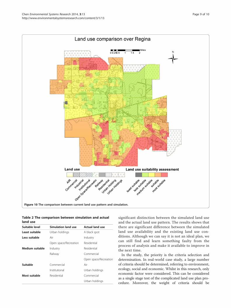
Figure 10 The comparison between current land use pattern and simulation.
Table 2 The comparison between simulation and actualland use
Suitable level Simulation land use Actual land use
Least suitable Urban holdings A black spot
Less suitable Air Industry
Open space/Recreation Residential
Medium suitable Industry Residential
Railway Commercial
Open space/Recreation
Suitable Commercial Air
Institutional Urban holdings
Most suitable Residential Commercial
Urban holdings
Chen Environmental Systems Research 2014, 3:13 Page 9 of 10http://www.environmentalsystemsresearch.com/content/3/1/13
significant distinction between the simulated land useand the actual land use pattern. The results shows thatthere are significant difference between the simulatedland use availability and the existing land use con-ditions. Although we can say it is not an ideal plan, wecan still find and learn something faulty from theprocess of analysis and make it available to improve inthe next time.In the study, the priority is the criteria selection and
determination. In real-world case study, a large numberof criteria should be determined, referring to environment,ecology, social and economic. Whilst in this research, onlyeconomic factor were considered. This can be consideredas a single stage test of the complicated land use plan pro-cedure. Moreover, the weight of criteria should be

Chen Environmental Systems Research 2014, 3:13 Page 10 of 10http://www.environmentalsystemsresearch.com/content/3/1/13
determined by both experts and stakeholders. In this re-search, the weight was just determined by literal evalu-ation from municipal land use project plan.Secondly, the simulation of suitable level is simplified,
whilst in the real world, the development pattern iscomplicated. In the analysis, development scenarios inland use are not easy to pin down. There are no univer-sal rules as to what they should or should not include,and there are no tools available to generate them auto-matically. F.C. Dai et al. set two scenarios in their studyof urban fringe land use planning. One is mainly basedon the actual development simulation, and the otherscenario is mainly depended on the government plan-ning. Thus, setting scenarios might increase the accuracyof the simulation as well as the reliability.Moreover, as it is under a small scale analysis, the sim-
plified definition is considered to be acceptable. However,the definition of suitability level results in unprofessional.Take the black spot in the least suitable level for example.It is hard to explain its appearance. It might be assumedto be the fault in the multi-criteria analysis procedure.And beyond the public opinion survey and social investi-gation, the suitability assessment seems to be groundless.Thus, the result might be better if the operational researchis implemented in the future study.
ConclusionAssessing the land use development problem has be-come an important task under the increasing aware ofland resource conservation. Land use suitability assess-ment is a practical tool to make decision on land use de-velopment. However, less works could be found that usequantized index to evaluate the land resource usage atPrairie Provinces in Canada. This study applied GIScombined with multi-criteria decision analysis ideologyin the City of Regina to assess land use condition withthree important criteria referring to social and economic.Finally, a map with five suitability levels can be obtained.When comparing the simulated land use suitable classes
with the existing land use pattern, we can find that: thesignificant differences between these two land use patternsreflect the limitation of the approach and data availability.Two possibilities are put forward to increase the reliabilityand accuracy of land use suitability assessment, where theresearch is potentially valuable. Urban land use categoriesare complicated process. Recommendations made for fu-ture studies is to improve the efficacy and objectivity oflocal land use evaluation to support the land use suitabilityassessment and avoid the subjectivity. As for the accuracyof the real-world case study, the criteria selection and theweight assignment should be widely and deeply discussedand researched.The results represent the potential of GIS-based evalu-
ation for urban planning purpose. However, it needs to
be emphasized that the reliability of the assessment re-sults depends on a multitude of factors ranging from thequality of the database to the potential errors in the GIS.Meanwhile, the modeling results are highly significant tothe weights applied. The determination of a multitude offactors and weights for the various factors is one of themost important challenges in the future.
Competing interestsThe author declares that she has no competing interests with anyone.
Author’s contributionsJC carried out the data collection, methods, results analysis and finish themanuscript.
AcknowledgementThis research has been conducted within University of Regina. The Terraseverand Terra lab provided the equipment and materials for this research. Thisresearch is also supported by Dr. Joe Piwowar in the data collection andDr. Gordon Huang.
Received: 12 December 2013 Accepted: 11 March 2014Published: 2 July 2014
ReferencesAntoine J, Fischer G, Makowski M (1997) Multiple criteria land use analysis. Appl
Math Comput 83:195–215Cheng S, Chan CW, Huang GH (2003) An integrated multi-criteria decision
analysis and inexact mixed integer linear programming approach for solidwaste management. Eng Appl Artif Intel 16(5):543–554
Collins M, Steiner F, Rushman M (2001) Land-use suitability analysis in the UnitedStates: historical development and promising technological achievements.J Environ Manage 28(5):611–621
Dai F, Lee C, Zhang X (2001) GIS-based geo-environmental evaluation for urbanland-use planning: a case study. Eng Geol 61(4):257–271
Gomes E, Lins M (2002) Intergrating geographical information systems andmulti-criteria methods: a case study. Ann Oper Res 116:243–269
Huang G, Xia J (2001) Barriers to sustainable water-quality management.J Environ Manage 61:1–23
Joerin F, Thériault M, Musy A (2001) Using GIS and outranking multicriteriaanalysis for land-use suitability assessment. Int J Geogr Inf Sci 15(2):153–174
Kiker G, Bridges T, Varghese A, Seager T, Linkov I (2005) Application ofmulticriteria decision analysis in environmental decision making. IntegrEnviro Assess Manage 1(2):95–108
Kunwar P, Kachhwaha T, Kuma A, Agrawal AK, Singh A, Mendiratta N (2010) Useof high-resolution IKONOS data and GIS technique for transformation oflanduse/landcover for sustainable development. Curr Sci India 98(2):204–212
Leung H (2003) Land use Planning Made Plain. University of Toronto Press,Toronto, Canada
Liu Y, Lv X, Qin X, Guo H, Yu Y, Wang J, Mao G (2007) An integrated GIS-basedanalysis system for land-use management of lake areas in urban fringe. LandScape Urban Plan 82(4):233–246
Malczewski J (1999) GIS and multicriteria decision analysis. John Wiley & Sons.Malczewski J (2004) GIS-based land-use suitability analysis: a critical overview. Pro
Plann 62(1):3–65Malczewski J (2006) GIS‐based multicriteria decision analysis: a survey of the
literature. Int J Geogr Inf Sci 20(7):703–726Phua M, Minowa M (2005) A GIS-based multi-criteria decision making approach
to forest conservation planning at a landscape scale: a case study in theKinabalu Area, Sabah, Malaysia. Land Scape Urban Plan 71(2):207–222
Sharifi M, Boerboom L, Shamsudin K, Veeramuthu L (2006) Spatial MultipleCriteria Decision Analysis in Integrated Planning for Public Transport andLand use Development Study in Klang Valley, Malaysia. ISPRS TechnicalCommission 2nd Symposium, United States, pp 85–91
doi:10.1186/2193-2697-3-13Cite this article as: Chen: GIS-based multi-criteria analysis for land usesuitability assessment in City of Regina. Environmental Systems Research2014 3:13.