Embed Size (px)
Citation preview

1
THREE VALLEYS MUNICIPAL WATER DISTRICT REQUEST FOR PROPOSALS
GEOGRAPHIC INFORMATION SYSTEM (GIS) ENTERPRISE EXPANSION PROJECT
PROPOSAL DUE DATE: 5:00 pm on Wednesday, August 4, 2021
1. INTRODUCTION
The THREE VALLEYS MUNICIPAL WATER DISTRICT (TVMWD or District) is requesting proposals from professional consulting firms for an enterprise expansion of its Geographic Information System (GIS). TVMWD plans to further develop and implement its existing GIS system into an enterprise system that can be expanded and improved to address the current and future needs of the District. Three Valleys Municipal Water District is one of twenty-six-member agencies of the Metropolitan Water District of Southern California (MWD). The District is a public wholesale water purveyor that supplies supplemental potable water to its thirteen member-agencies within the Pomona, Walnut, and East San Gabriel Valleys along eastern Los Angeles County. TVMWD owns and operates the Miramar Water Treatment Plant (Miramar), a 25-million-gallon per day treatment facility located in the City of Claremont along with approximately 8 miles of large diameter transmission mains. The District’s Miramar plant and transmission system delivers supplemental potable water to its thirteen-retail municipal, publicly and privately held water companies who supply drinking water to its retail customers in addition to imported water purchases from MWD to meet all drinking water needs within the District’s service area.
2. BACKGROUND
TVMWD currently uses ArcGIS Online and recently decommissioned a proprietary GIS system. The existing technical limitations present a technology gap that limit the District from achieving strategic goals and objectives. The overall goal of the project is to implement a scalable, centralized, and customizable enterprise-wide GIS to support our existing and future requirements in a cost-efficient manner. TVMWD conducted a data conversion in 2006-2007 timeframe into ArcGIS. Other assets have been installed since then and will require conversion: Fulton Reservoir, Miramar Pipeline Manways, Valves, Meters, SCADA Cabinets, groundwater

2
production wells, and other assets. The District has contracted with a GIS consultant to accomplish this data conversion task and updated the core GIS data layers upon which to build other GIS layers and applications. With this GIS data in place, TVMWD is seeking proposals to further develop its GIS data, improve asset data quality, enhance workflows, and increase enterprise accessibility to GIS information.
3. PROPOSAL OBJECTIVES
TVMWD is in the early stages of our GIS program. The approach is to setup a solid foundation by focusing on:
data development and quality, establishing best practices, staff training, increasing user adoption, introducing low-risk/high-reward workflows, enabling the District to pursue future initiatives that are dependent on GIS.
The main objectives of this project are as follows:
1. Expand the existing GIS capabilities to an enterprise-wide system to support current and future goals.
2. Centralize disparate GIS data into a single source of truth relational database designed with an industry standard asset information model.
3. Maintain the most up-to-date, accurate, and high-quality asset infrastructure data by developing new workflows and applications to view, edit, update, remove, and collect GIS asset infrastructure data in an operationally efficient and effective manner.
4. Provide staff focused training with GIS tools to maximize benefits of an enterprise GIS and enhance staff capabilities.
4. CURRENT SYSTEMS AND IT INFRASTRUCTURE
4.1 Geographic Information System
TVMWD currently uses ArcGIS Online with a Standard Feature Datastore to access data, web maps, and conduct basic analysis. Future TVMWD goals provide an opportunity to integrate systems with GIS and enhance reporting capabilities to make informed, data-driven business decisions.

3
Table 1 - Current ArcGIS Online Members
User Department
User Type Role
Information Technology
GIS Professional Basic
Administrator
Administration Viewer Viewer Engineering Creator Viewer Engineering Viewer Viewer Operations Viewer Data Editor Operations Viewer Viewer Operations Field
Worker Data Editor
GIS Data
One of TVMWD’s GIS data sources is from a recently decommissioned proprietary GIS export. It contains the most up-to-date asset infrastructure data. The geodatabase is stored in Microsoft Access format and contains 257 tables with 626,827 records. This data is identified in the Scope of Work to migrate into the proposed geodatabase and can be available for review by contacting Robert Peng at [email protected]. TVMWD currently has an ArcGIS Online subscription with a Standard Feature Datastore.
Table 2 – Asset Objects in ArcGIS Online Dataset - Object Objects Reservoir 3 Booster Station 12 Hydro Station 2 Lateral Line – Air Release 83 Lateral Line - Blowoff 28 Lateral Line – Commercial 9 Lateral Line – Sampling 14 Main Line - Distribution 235 Main Line - Transmission 395 Casing 3 Easement 3 Water Structure – Booster Pump 1 Water Structure - Hydro 2 Water Structure – Meter Connection 14

4
Water Structure – Pump back Station 2 Water Structure – Reservoir 2 Water Structure - Vault 24
4.2 Enterprise Systems and Business Applications Table 3 – Enterprise Systems Related to GIS
System Product Email Exchange Online Automatic Vehicle Location
Network Fleet
Supervisory Control and Data Acquisition (SCADA)
Contact Robert Peng at [email protected] for vendor/product. Accessible data historian development in progress.
Hydraulic Modeling Innovze InfoWater Software Access and Identity Active Directory, Azure AD File Repositories SharePoint Online
4.3 IT Infrastructure and Hardware
Servers Windows-based servers are 100% virtualized with two physical hosts running on VMWare. TVMWD is also capable of provisioning servers hosted on Microsoft Azure and Amazon Web Service (AWS).
GNSS Receiver TVMWD has a GPS Trimble R1 GNSS Receiver, pole mount, and receiver antenna to support data collection. Devices Mobile devices include Microsoft Surface Pros, iPads, and smart phones (iOS and Android).
5. FUTURE GOALS
The following list contains potential future TVMWD goals that are anticipated to interact or integrate with the proposed system. Consultants shall take these future goals into consideration in relation to future phases of TVMWD’s GIS program and identify any limitations or opportunities with their proposed solution:
Asset Management System

5
Digitize and enhance workflows o Work Orders
Preventative Maintenance Reactive Maintenance
o Meter Reading o Inspections
Document Management System integration Financial Accounting System integration Emergency Response/Emergency Preparedness/Emergency Operations
Center Enhancements SCADA Historian integration Advanced Metering Infrastructure integration Water Information System (Metropolitan Water District of Southern
California) data integration Business Intelligence/Data Analytics
6. SCOPE OF WORK
6.1 Meetings
Consultant will conduct a project kick-off meeting with TVMWD staff to discuss the approach, technical requirements, project schedule, existing GIS data, and other data sources that will integrate with GIS.
Consultant will coordinate and conduct bi-weekly, or as needed, project status
update meetings with TVMWD staff to discuss project schedule, open issues, completed tasks, backlog, action items, risks and mitigations, and changes to scope related to the project. Meeting agendas and notes shall be provided to TVMWD as deliverables.
Consultant will coordinate and conduct planning meetings for all proposed
workflows to understand TVMWD existing business processes, collect staff input, identify business and technical requirements, and provide new workflow recommendation(s) to implement.
6.2 System Implementation
TVMWD will provision servers and related licensing based on a mutually agreed system architecture design. Consultant will install, configure, test, and deploy Esri ArcGIS 10.6.1 (minimum) for the following compute environments:

6
Development (on-premise) – The primary purpose of the development environment is to test for changes and upgrades.
Production (on-premise) – This environment will contain the enterprise geodatabase and serve as the central repository of authoritative data.
Production (cloud) – This environment will include the District’s ArcGIS online which is used to host public-facing maps and applications. It will also be used to securely serve maps and services to users outside of the District firewall.
TVMWD will acquire Esri licenses for the project (“Exhibit B”). Consultant will
download, install, configure, test, and deploy software and services.
Migrate personal geodatabase to a SQL based Esri enterprise geodatabase. The Consultant shall develop detailed data conversion specifications, validation rules and load the data accurately in a single coordinate system without any data loss.
Install, configure, test, and deploy the Innovyze InfoWater interface.
Update digital aerial imagery sufficient to meet National Map Accuracy for the
capture of features at 1” = 50’ scale. The maximum pixel resolution should be no greater than 6 inches. Provide the District a seamless mosaic if its service area and surrounding areas with a pixel resolution of 2 feet or less.
6.3 Applications and Workflows Implementation
Optimize the Underground Service Alert (“DigAlert”) workflow with software capable of integrating DigAlert’s web service to enable Positive Response. Application will support responsive-design and is usable on both desktop browsers and mobile devices. Mobile app can be used as an alternative for a web browser on mobile devices. Additional requirements include a DigAlert monitoring dashboard, automated email notifications and visually representing the DigAlert ticket boundary on the interface.
Develop a standardized workflow to convert and load AutoCAD files into the
enterprise geodatabase. The workflow should allow TVMWD staff to define a spatial reference, add CAD data to a map, change display properties, and georeference CAD data.
Develop a standardized workflow and application for redlining assets that
have moved, changed, or added in the field. The application should be designed for mobile devices and work in both connected and disconnected (offline) modes. The TVMWD Trimble R1 GNSS receiver should be

7
incorporated into the workflow to capture location information when applicable. The workflow shall capture field observation, data collection, and commit changes to the geodatabase. Incorporate quality control and quality assurance methods to ensure high data quality.
Document hyperlinking (As-builts, photos, link the pipe inspection videos by
segments, etc.). This will allow field Operations Staff to access As-Builts, photos, and other types of data for specific assets while in the field on a mobile device in both disconnected and connected modes.
6.4 Services
Provide 40 hours of field data collection and/or field verification service to capture vertical assets at TVMWD water treatment plant and assets at two new well sites. Consultant will also provide hourly rates for field data collection and/or verification services.
6.5 Documentation
The Consultant will provide documentation for system architecture, system manuals, software licenses, user guides, workflow maps, training documents, video tutorials, maintenance plans, and any other documents related to the project.
6.6 Training
The Consultant will provide two (2) or more hours of comprehensive “on-the-job” training to impacted stakeholders for new software and implemented workflows to enable the proficient use of the proposed system.
6.7 Support (Optional) Provide 1-year of general support for configuration and interface changes, end user support, software maintenance, and administration of the geodatabase. 7 PROPOSAL REQUIREMENTS AND INFORMATION
7.1 Proposal Requirements
Cover Letter
The Consultant’s legal name, address, telephone number, e-mail address, and the principal contact person.

8
Any qualifying statements or comments regarding the Consultant’s proposal, including proof of the Consultant’s capabilities to meet the DWR (Department of Water Resources) Guidebook; and
Statement indicating the validity of the proposal for a minimum period of 90 calendar days after the proposal due date.
Statement of Experience and Qualifications
Provide an organization chart of the proposed team for the project, including
resumes for key personnel with their roles and responsibilities. At a minimum, identify the project manager to work on this project.
Provide information on at least three (3) similar projects completed in the last seven (7) years. For each project, describe the project by name, type, location, year completed, and contact information. Project references should list contact name, telephone number, and email address.
Provide additional relevant information that demonstrates the team’s qualifications.
Project Schedule
Provide a project schedule showing the time required to complete the
scope of work. The schedule should include tasks, milestones, and dependencies.
Project Understanding and Approach
Describe your understanding and approach of the project objectives and
address your approach to the major elements outlined in the scope of work. You may include additional tasks that may add value to the project.
Provide a high-level system architecture design of servers,
desktops/devices, applications, web portals, services, data, and other technology to support an enterprise implementation framework. The system architecture design should be able to meet the District’s existing business needs and be scalable to meet future business needs identified as Future Goals in Section 5.
Cost Proposal
Submit a detailed cost proposal of all services, licenses, labor, and materials anticipated in completing the scope of work.
The cost submittal should indicate the number of anticipated hours by the Project Manager and key project personnel. The estimated level of hours for other staff can be summarized in general categories.

9
The cost proposal should include the names, title, hourly rates, overhead factors along with any other details by which the overall project element costs have been derived.
Objections to Professional Services Agreement
Objections shall be submitted in writing with justification clearly stated. Any Consultant with objections to the terms contained in the District’s Professional Services Agreement (“Exhibit A”) must advise the District of such objections and requested modifications as part of its Technical proposal. Failure of a proposer to accept the terms of the District’s Professional Services Agreement may result in the rejection of the proposal. It shall be the responsibility of the prospective Consultant to review all sections and exhibits of the Professional Services Agreement, including insurance requirements. If no objections are received, the District will assume the proposer is able to and will enter into the Professional Services Agreement and fulfill the terms and requirements set therein. The District may recover any damages accruing to the District as a result of the successful Consultant’s failure or refusal to execute the District’s Professional Services Agreement.
7.2 Proposal Submittal The District requests that the proposals be submitted electronically (email) to Robert Peng at [email protected] on or before 5:00 p.m. on August 4, 2021. All proposal components must be received by the deadline. Late proposals will not be accepted. The official and determining time of proposal submission shall be according to the timestamp that indicates receipt of the proposal submission in Mr. Peng’s email inbox. It is the proposer’s sole responsibility to see that its proposal is received by the deadline. 7.3 Anticipated Schedule RFP Event Date - Time RFP Issued July 1, 2021 Deadline for Clarifications/Questions July 21, 2021 Answers to Questions Provided July 28, 2021 Deadline for Proposal Submittal August 4, 2021 5:00 PM Finalists Notified August 12, 2021 Finalists Presentations/Interviews August 25, 2021 Complete Proposal Evaluations September 8, 2021 Contract Award September 15, 2021

10
8 SELECTION CRITERIA
The District is seeking the most responsive and best qualified Consultant to collaborate with the District and successfully implement an enterprise GIS relative to the District’s needs. District staff will convene a Selection Team to evaluate each proposal for completeness and content. Each proposal will be evaluated based upon the criteria listed below. Failure to submit a proposal that does not adhere to all the requirements of the RFP shall result in disqualification. The proposal evaluation will focus on the following criteria:
Experience and Qualifications
Project Understanding and Approach
System Architecture Design
Costs
Schedule
Presentation/Interview
TVMWD will select the consultant based on the merits of the proposal including criteria listed above. At least three current references should be provided for relevant work. Depending on the number of proposals received, TVMWD may elect to invite selected firms to give a brief presentation of its proposal and answer questions at TVMWD headquarters. Upon final review, TVMWD staff will recommend a final selection to its Board of Directors. Award of contract for this project is anticipated on September 15, 2021. TVMWD will select the proposal(s) that best meet its needs and no one criteria will be determinative. TVMWD may conduct oral interviews, which may be scheduled after initial review and ranking of the proposals. Consultant selection for the short list shall be done in writing. Contract negotiation will commence following the selection oral interviews and TVMWD Board of Directors approval of selected Consultant. 9 TERMS AND CONDITIONS
9.1 Professional Services Agreement
The District will identify the firm that best meets the needs of the District and enter contract negotiations with that highest ranked firm. Should the District fail to reach an agreement with the top ranked firm, the District may enter negotiations with the next highest rated firm and so on. District staff will make recommendations to the Board for the award of the Professional Services Agreement to the firm the best

11
furthers the District’s objectives. The successful Consultant will be expected to execute the attached Professional Services Agreements (“Exhibit A”) by September 22, 2021.
9.2 Insurance Requirements
The successful Consultant shall secure all insurance required under the Professional Services Agreement, and provide any necessary documentation to the District, by September 22, 2021 if an award is made.
9.3 Acceptance or Rejection of Proposal
The District reserves the right to accept or reject any and all proposals. The District also reserves the right to waive any informality or irregularity in any proposal or in the bidding as deemed to be in its best interest. Additionally, the District may, for any reason, decide not to award an agreement as a result of this RFP or cancel the RFP process. The District shall not be obligated to respond to any proposal submitted, nor be legally bound in any manner by the submission of the proposal. The District reserves the right to negotiate project deliverables and associated costs.
9.4 Gratuities
No person will offer, give, or agree to give any District employee, its representative, or participating member agency any gratuity, discount or offer of employment in connection with the award of contract by the District. No District employee or its representative will solicit, demand, accept or agree to accept from any other person a gratuity, discount or offer of employment in connection with a District contract.
9.5 Equal Opportunity Clause
Contractors shall ensure against discrimination in employment practices on the basis of race, color, national origin, ancestry, sex, or religion will be required. The District hereby ensures that minority business enterprises will be afforded full opportunity to submit proposals in response to this notice and will not be discriminated against on the basis of race, color, national origin, ancestry, sex, or religion in any consideration leading to the award of contract.
9.6 Equal Opportunity Employment Compliance
Proposer certifies that it has sought out and considered minority business enterprises for those portions of the work to be subcontracted and has fully documented such actions that said documentation is open to inspection, and that said action will remain in effect for the life of any contract awarded hereunder. Furthermore, Proposer certifies that all steps will be taken to meet all equal employment opportunity requirements of the contract documents. Proposer certifies that in all previous contracts or subcontracts, all reports which may have been due
12
under the requirements of any agency, State, or Federal equal employment opportunity orders have been satisfactorily filed, and that no such reports are currently outstanding.
9.7 Legal Responsibilities
All proposals must be submitted, filed, made, and executed in accordance with State and Federal laws relating to proposals for contracts of this nature whether the same or expressly referred to herein or not. Any company submitting a proposal will by such action thereby agree to each and all of the terms, conditions, provision, and requirements set forth, contemplated, and referred to in the RFP, and other contract documents, and to full compliance therewith.
9.8 Proposal Preparation Costs
The District will not pay any costs associated with the preparation, submittal, or presentation of any proposal.
9.9 Proposal Withdrawal
To withdraw a proposal, the Proposer must submit a written request electronically (email), signed by an authorized representative, to the RFP Coordinator identified in Section 7. After withdrawing a previously submitted proposal, the Proposer may submit another proposal at any time up to the deadline for submitting proposals.
9.10 Proposal Errors
Proposers are liable for all errors or omissions contained in their proposals. Proposers will not be allowed to alter proposal documents after the deadline for submitting a proposal.
9.11 Incorrect Proposal Information
If the District determines that a Proposer has provided, for consideration in the evaluation process or contract negotiations, incorrect information which the Proposer knew or should have known as materially incorrect, the proposal will be determined non-responsive, and the proposal will be rejected.
9.12 Discrepancies and Misunderstandings
Contractors and consultants must satisfy themselves by personal examination of the work site, specifications, and other contract documents and by any other means as they may believe necessary, as to the actual physical conditions, requirements, and difficulties under which the work must be performed. No contractor or consultant will at any time after submission of a proposal make any claim or assertion that there

13
was any misunderstanding or lack of information regarding the nature or amount of work necessary for the satisfactory completion of the job. Any errors, omissions, or discrepancies called to the attention of the District of will be clarified by the District in writing to all proposers prior to the submission of proposals.
9.13 Proposer Interested in More than One Proposal
No person, firm, or corporation will be allowed to make or file, or be interested in more than one proposal for the same work unless alternate bids are specifically called for. No proposal will be accepted from a consultant who has not been licensed in accordance with the provisions of the State Business and Professional Code.
9.14 Non-Collusions Affidavit
Proposer declares that the only persons or parties interested in this proposal as principals are those named herein; that no officer, agent, or employee of the District is personally interested, directly or indirectly, in this proposal; that this proposal is made without connection to any other individual, firm, or corporation making a bid for the same work and that this proposal is in all respects fair and without collusion or fraud.

14
EXHIBIT A

15

16

17

18

19

20

21

22

23
24

25

26
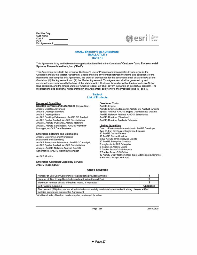
EXHIBIT B
Page 27

Page 28

Page 29

Page 30

Page 31

Page 32