Embed Size (px)
Citation preview
Report to: EXECUTIVE CABINET
Date: 12 December 2018
Executive Member/Reporting Officer:
Councillor Warren Bray – Executive Member, Strategic Development and Transport.
Peter Taylor – Head of Planning
Subject: SITES OF BIOLOGICAL IMPORTANCE AND REGIONALLY IMPORTANT GEOLOGICAL AND GEOMORPHOLOGICAL SITES REVIEW UPDATE
Report Summary: This paper provides an update on changes which have occurred to designated Sites of Biological Importance (SBI) and Regionally Important Geological and Geomorphological (RIGs) sites within the Borough. These are sites which have been surveyed by or under the supervision of the Greater Manchester Ecology Unit in 2016.
Recommendations: That the changes to the Boroughs SBI and RIGS designated Sites of Biological Importance (SBI) and Regionally Important Geological and Geomorphological (RIGs), be approved.
Links to Community Strategy:
SBI are a designation introduced in the 1980’s and have been adopted as a key planning guide and environmental protector by Greater Manchester. RIGs have received recent support for designation across Greater Manchester as a local designation. Both are closely linked to the Community Strategy, making Tameside a more attractive place to live.
Policy Implications: SBI and RIGs are integral to retaining Tameside’s biological and geological diversity and underpin the Authority’s existing Local Plan the Unitary Development Plan, proposed Local Plan and the Tameside Countryside Strategy.
Financial Implications: (authorised by Section 151 Officer)
There are no direct financial implications as a result of this report.
Legal Implications:(authorised by Borough Solicitor)
The designation and review of SBI are non-statutory functions. However, the designation and evidence base behind it would be material considerations in considering any development that might affect the land concerned. It is important that we ensure any planning documentation are aligned and do not contradict each other before published.
Risk Management : The consequence of not adopting the revisions to Tameside’s existing SBI and RIGs will result in the Council failing to utilise the most recent and up to date specialist ecological and geological advice available. This may result in the Council determining planning applications, formulating policy, managing its countryside or providing advice, based on out of date information and evidence.
Access to Information : The background papers relating to this report can be inspected by contacting Graham Holland, Senior Planning Policy Officer
1.0 BACKGROUND
1.1 Sites of Biological Importance (SBI) are a non-statutory designation used by all Greater Manchester Combined Authorities (GMCA) to protect locally valued sites of biological diversity and ecological importance. Sites are based on a detailed survey, first carried out between 1980 and 1983 in conjunction with key naturalist groups.
1.2 Regionally Important Geological and Geomorphological Sites (RIG’s) are a local designation recognising locations which are the most important places for geology and geomorphology outside of statutorily protected land such as Sites of Special Scientific Interest (SSSI) and are used across GMCA.
1.3 The review process of SBI’s is conducted on an annual basis and updated by the Greater Manchester Ecology Unit (GMEU), guided by selection criteria adopted in 2008 and recently updated in 2016. The full criteria can be viewed online at www.tameside.gov.uk/ecologyunit/sbi. The annual review usually covers around 15% of sites, by number, within any one Borough. It may therefore be several years since the sites listed below in Table 1 were last reviewed.
1.4 The review process of RIGs is undertaken by a group of suitably qualified volunteer geologists from the Greater Manchester RIGs Group associated with the Manchester Geological Association, assessing sites in accordance with nationally agreed guidance and overseen by the Greater Manchester Ecology Unit.
1.5 The SBI site review process may propose a number of changes including to boundaries, site suitability, list descriptions, reclassify grades, include new sites or delete existing ones. As the review process is seasonal in nature and conducted across GMCA, there is typically a lag between the onsite survey, write up and spatial mapping of information and therefore the review being presented to all councils.
1.6 Although there are a large number of potential RIG’s across Greater Manchester, for a number of years these have not been brought forward for formal adoption until relatively recently as a result of a more positive policy position contained within the National Planning Policy Framework (NPPF) and professional capacity to survey such locations. RIG’s unlike SBI are not graded (detailed further below) with updates either confirming sites for selection or not, amending boundaries or updating descriptions.
1.7 It is the results of the 2016 review of SBI and RIGs which are presented.
1.8 The council is obliged to adopt advised updates to enable them to be covered by local plan policy. SBI and RIGs are given protection from inappropriate development in section 15 of the National Planning Policy Framework (NPPF) and Unitary Development Plan (UDP) policies N1a (International Nature Conservation Sites), N1b (National Nature Conservation Sites) and N2 (Locally Designated Nature Conservation Sites).
1.9 A grading system (detailed below, 1.10) is used in selecting SBI in order to reflect the range of both ecological and landscape characteristics of an area and the diversity of habitats which sites support rather than the level of planning protection afforded. Sites identified as grade C therefore do not necessarily have lesser protection from development through the planning system, as the merits of sites are considered on an individual basis.
1.10 SBI grade designated dependent on type and condition. These are: Grade A: Of Regional or County Importance Grade B: Of District Importance Grade C: Of importance within the identical geographical locality.
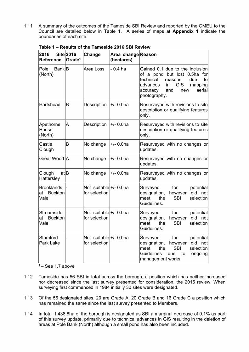
1.11 A summary of the outcomes of the Tameside SBI Review and reported by the GMEU to the Council are detailed below in Table 1. A series of maps at Appendix 1 indicate the boundaries of each site.
Table 1 – Results of the Tameside 2016 SBI Review 2016 Site Reference
2016 Grade1
Change Area change (hectares)
Reason
Pole Bank (North)
B Area Loss - 0.4 ha Gained 0.1 due to the inclusion of a pond but lost 0.5ha for technical reasons, due to advances in GIS mapping accuracy and new aerial photography.
Hartshead B Description +/- 0.0ha Resurveyed with revisions to site description or qualifying features only.
Apethorne House (North)
A Description +/- 0.0ha Resurveyed with revisions to site description or qualifying features only.
Castle Clough
B No change +/- 0.0ha Resurveyed with no changes or updates.
Great Wood A No change +/- 0.0ha Resurveyed with no changes or updates.
Clough at Hattersley
B No change +/- 0.0ha Resurveyed with no changes or updates.
Brooklands at Buckton Vale
- Not suitable for selection
+/- 0.0ha Surveyed for potential designation, however did not meet the SBI selection Guidelines.
Streamside at Buckton Vale
- Not suitable for selection
+/- 0.0ha Surveyed for potential designation, however did not meet the SBI selection Guidelines.
Stamford Park Lake
- Not suitable for selection
+/- 0.0ha Surveyed for potential designation, however did not meet the SBI selection Guidelines due to ongoing management works.
1 – See 1.7 above
1.12 Tameside has 56 SBI in total across the borough, a position which has neither increased nor decreased since the last survey presented for consideration, the 2015 review. When surveying first commenced in 1984 initially 30 sites were designated.
1.13 Of the 56 designated sites, 20 are Grade A, 20 Grade B and 16 Grade C a position which has remained the same since the last survey presented to Members.
1.14 In total 1,438.8ha of the borough is designated as SBI a marginal decrease of 0.1% as part of this survey update, primarily due to technical advances in GIS resulting in the deletion of areas at Pole Bank (North) although a small pond has also been included.
1.15 Full details of Tameside’s SBI review and a complete list of SBI are given at Appendices 2 and 3.
1.16 There are a total of two RIG sites in Tameside, both of which were identified through the 2015 review. They are former quarry faces at Arden Bridge, Denton and Park Bridge, Ashton. No further sites have been identified through this 2016 review.
2.0 CONCLUSION
2.1 The GMEU review process provides consistency in reporting, recording and monitoring across Greater Manchester in supporting existing and forthcoming planning policy and the wider management and protection of local nature conservation assets.
2.2 It is important, therefore, that revisions to SBI and RIGS are noted and agreed by the Council.
3.0 RECOMMENDATIONS
3.1 As set out on the front of the report
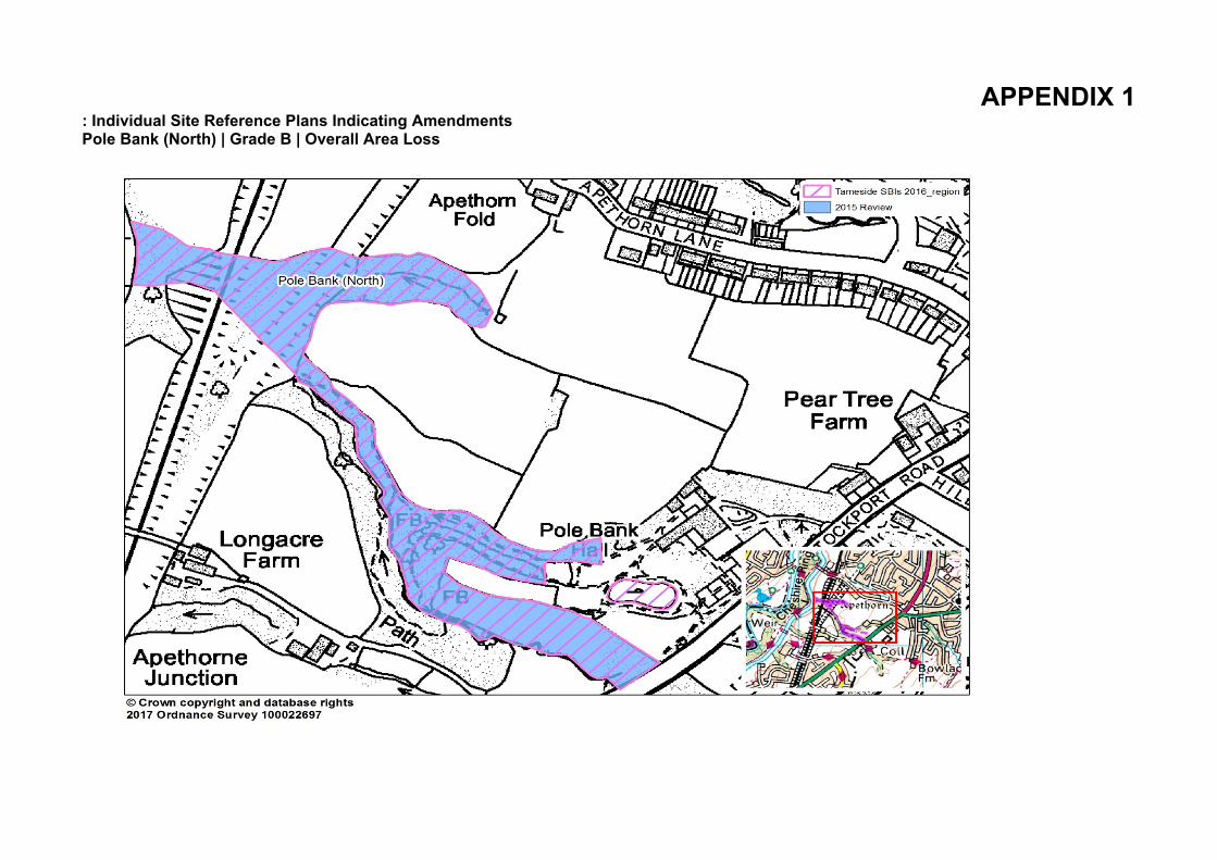
APPENDIX 1: Individual Site Reference Plans Indicating Amendments Pole Bank (North) | Grade B | Overall Area Loss
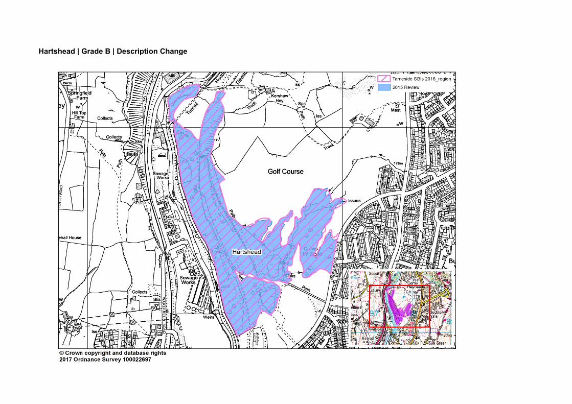
Hartshead | Grade B | Description Change
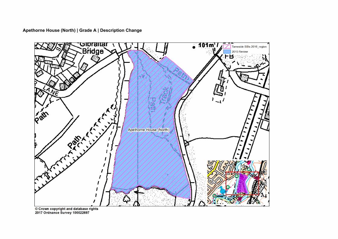
Apethorne House (North) | Grade A | Description Change
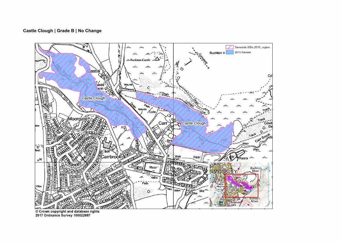
Castle Clough | Grade B | No Change
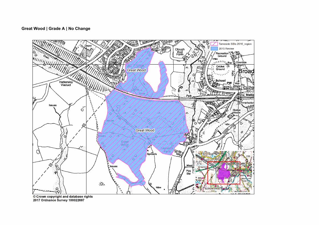
Great Wood | Grade A | No Change
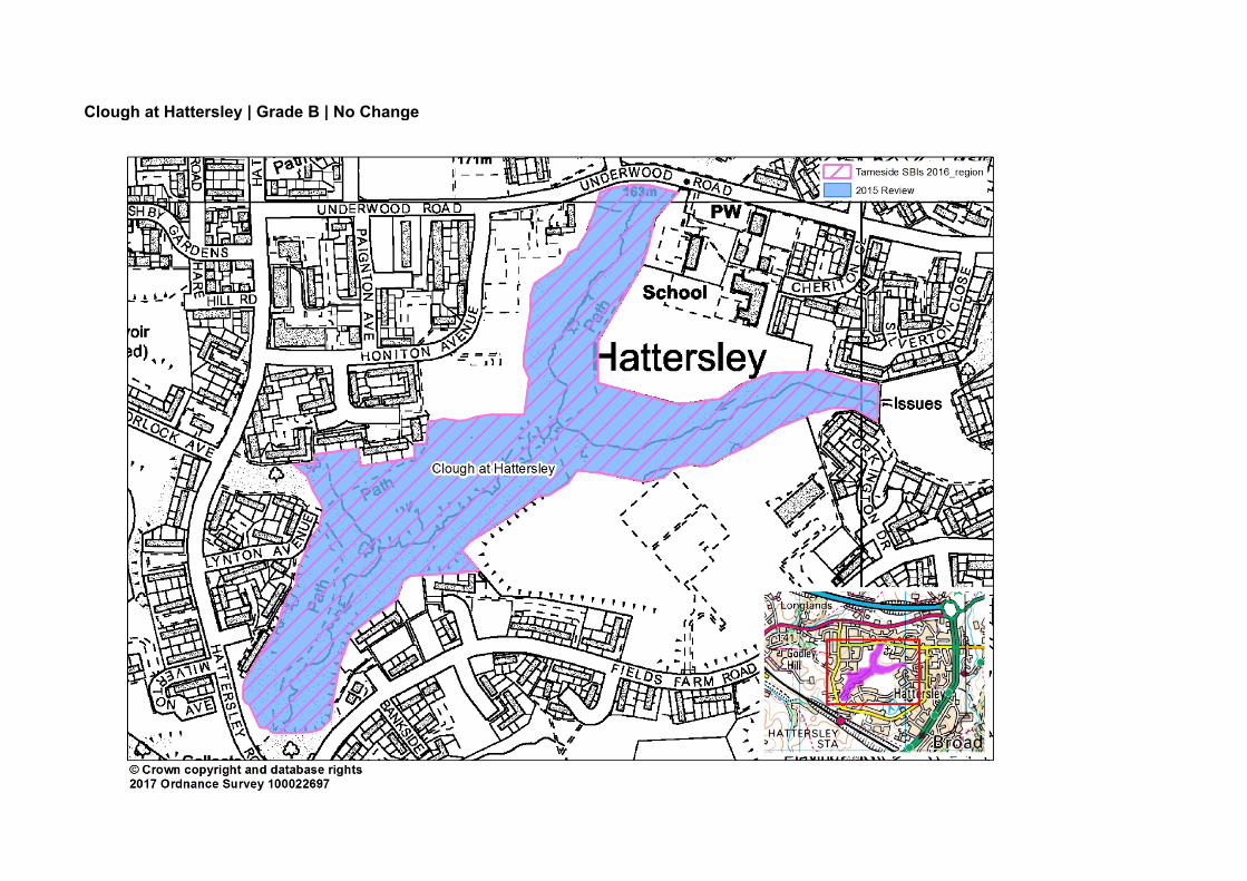
Clough at Hattersley | Grade B | No Change
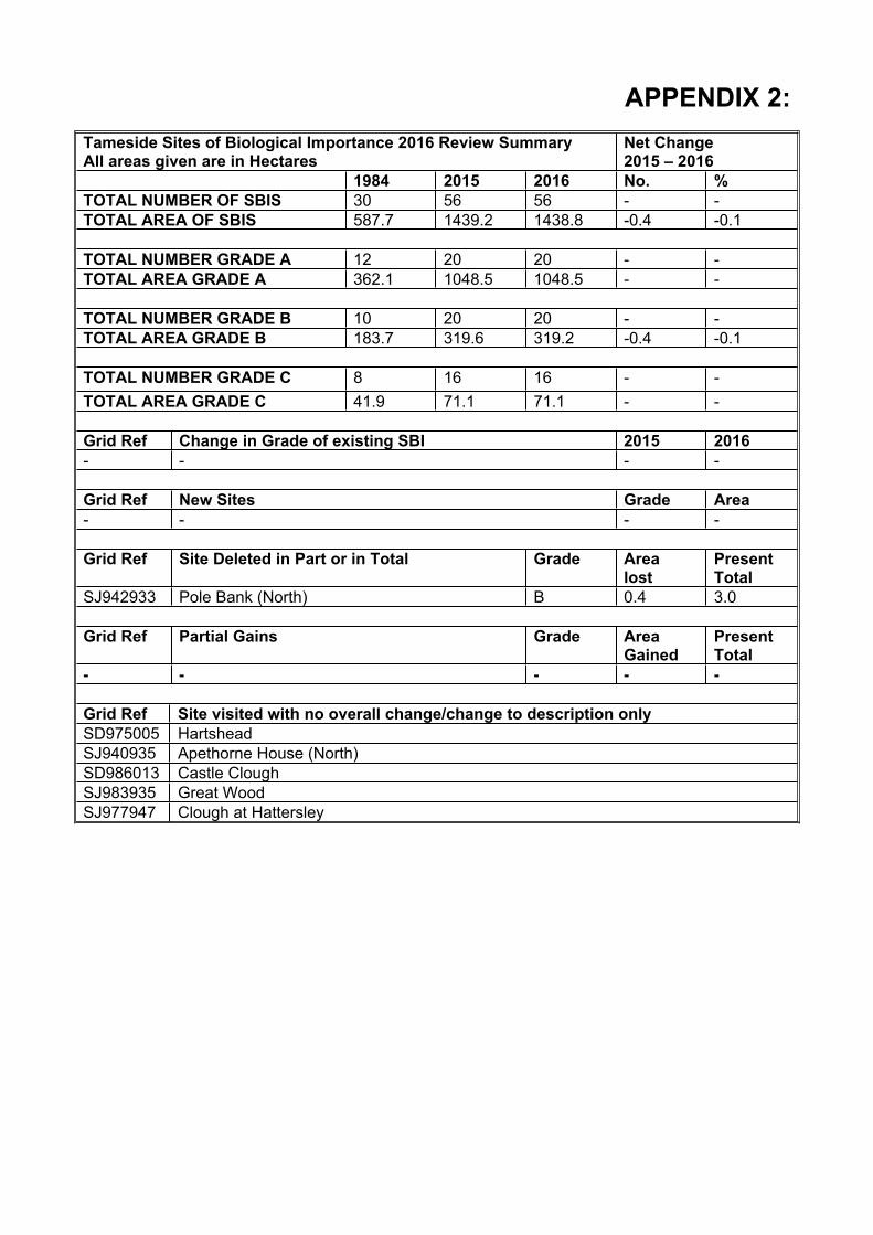
APPENDIX 2:Tameside Sites of Biological Importance 2016 Review SummaryAll areas given are in Hectares
Net Change2015 – 2016
1984 2015 2016 No. %TOTAL NUMBER OF SBIS 30 56 56 - -TOTAL AREA OF SBIS 587.7 1439.2 1438.8 -0.4 -0.1
TOTAL NUMBER GRADE A 12 20 20 - -TOTAL AREA GRADE A 362.1 1048.5 1048.5 - -
TOTAL NUMBER GRADE B 10 20 20 - -TOTAL AREA GRADE B 183.7 319.6 319.2 -0.4 -0.1
TOTAL NUMBER GRADE C 8 16 16 - -TOTAL AREA GRADE C 41.9 71.1 71.1 - -
Grid Ref Change in Grade of existing SBI 2015 2016- - - -
Grid Ref New Sites Grade Area- - - -
Grid Ref Site Deleted in Part or in Total Grade Arealost
PresentTotal
SJ942933 Pole Bank (North) B 0.4 3.0
Grid Ref Partial Gains Grade AreaGained
PresentTotal
- - - - -
Grid Ref Site visited with no overall change/change to description onlySD975005 HartsheadSJ940935 Apethorne House (North)SD986013 Castle CloughSJ983935 Great WoodSJ977947 Clough at Hattersley
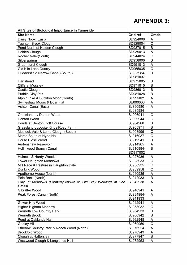
APPENDIX 3:All Sites of Biological Importance in TamesideSite Name Grid ref GradeDaisy Nook (East) SD924008 ATaunton Brook Clough SD929004 CPond North of Holden Clough SD937015 BHolden Clough SD939013 ARocher Vale (South) SD944024 CSilversprings SD958000 BGreenhurst Clough SD951013 AOld Kiln Lane Quarry SD965035 CHuddersfield Narrow Canal (South ) SJ935984-
SD981037B
Hartshead SD975005 BCliffs at Mossley SD971010 BCastle Clough SD986013 BPuddle Clay Pits SD981028 BAlphin Pike & Buckton Moor (South) SD995021 ASwineshaw Moors & Boar Flat SE000000 AAshton Canal (East) SJ890980 -
SJ935984A
Grassland by Denton Wood SJ906941 CDenton Wood SJ909944 CPonds at Denton Golf Course SJ904960 BGrassland opposite Kings Road Farm SJ905971 BMedlock Vale & Lumb Clough (South) SJ903995 CMarsh South of Hyde Hall SJ916937 CHorse Close Wood SJ919941 BAudenshaw Reservoir SJ914965 AHollinwood Branch Canal SJ910994-
SD917002B
Hulme’s & Hardy Woods SJ927936 ALower Haughton Meadows SJ928933 CMill Race & Pasture in Haughton Dale SJ938935 CDunkirk Wood SJ939958 CApethorne House (North) SJ940935 APole Bank (North) SJ942933 BClay Pit Meadows (Formerly known as Old Clay Workings at Gee Cross)
SJ942938 A
Gibralter Wood SJ940941 APeak Forest Canal (North) SJ934984-
SJ941933A
Gower Hey Wood SJ942941 AHigher Higham Meadow SJ958932 CWerneth Low Country Park SJ964933 BWerneth Brook SJ960942 BPond at Oaklands Hall SJ962948 AGodley Hill SJ969950 CEtherow Country Park & Roach Wood (North) SJ976924 ABrookfold Wood SJ970943 AClough at Hattersley SJ977947 BWestwood Clough & Longlands Hall SJ972953 A

Clough at Matley SJ973962 AEastwood & Acre Clough SJ971974 AMarshes at Staley Hall SJ974995 CBack Wood SJ979930 AStalybridge Country Park SJ982991 BGreat Wood SJ983935 AHurst Clough SJ987941 BRoe Cross Quarry SJ988966 CWild Bank Hill SJ984980 BBrushes SJ996993 BWoodland & Grassland at Landslow Green SK001971 BHollingworth Hall Wood SK007976 B