Embed Size (px)
Citation preview

REPORT ON THE SUTTON PROPERTY
MORRISETTE TOWNSHIP KIRKLAND LAKE, ONTARIO
Submitted by:
M.W. SuttonB.SG. Geology HonoursKirkland Lake, Ontario
42A01NE2049 2.26078 MORRISETTE 010


Previous work
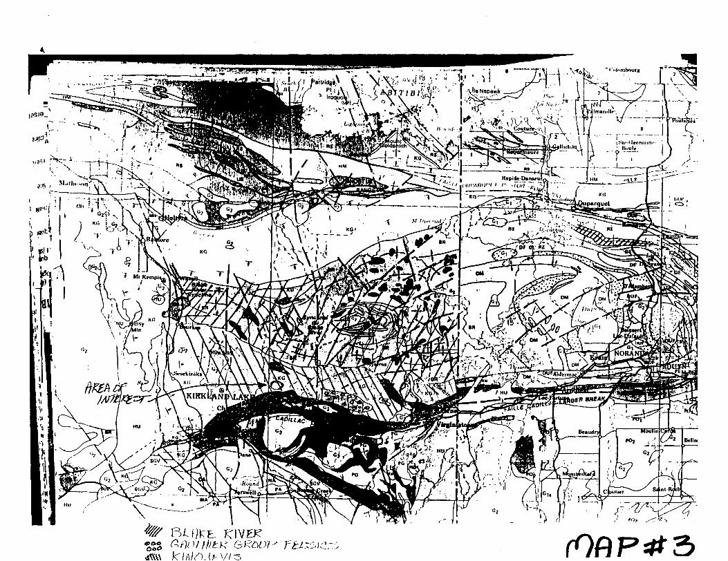
The Sutton claim units are located immediately north of the Kirana Mine. Although in close proximity to this mine, and along the same structure that mineralized it, the three claim units have no assessment work filed on them at the Mining Recorders office. The claims were patents until they came open in 2001 when I staked them. The only assessment work filed therefore was a more regional exploration programme carried out by Minnova in the period of 1987 to 1990. Minnova carried out extensive soil sampling, I.P. and magnetometer-VLF surveys, and did some drilling and trenching. They were focused on delineating gold zones such as the one at Kirana where 50,000 tons are reported to exist between surface and the top level at 0.48 ounce per ton (see Fig. #2, and #3). The shaft was reportedly sunk on a vein that returned "high values" in the shaft.
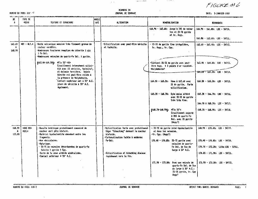
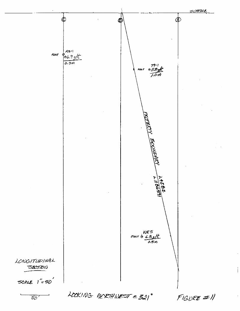
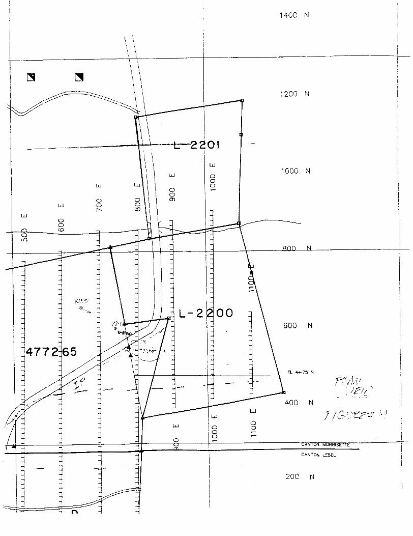
Minnova found difficulties in dealing with "cultural effects". Their geochemical soil surveys proved to be totally misleading due to the presence of wind-blown contaminants (tailings from nearby operations). They dropped the option due to overall unsatisfactory results. However, it appears that they did not drill the Kirana ore zone itself, and they did not follow up on some rather good individual results. Only one hole was drilled on the eastern part of the Kirana structure covering a one mile strike length; the hole they did drill is located on the Sutton claim. This hole, KIR-5, drilled in 1990, returned 6810 ppb (6.8 g/t) over 0.5 metre one one vein, and 1669 ppb (l .7 g/t) over 0.3 metre on another. The intersections are 164, and 204 metres downhole (@-50 degrees) respectively. This hole was drilled to follow up on a previously drilled hole, V-79-1, that had returned 11.8 g/t over 1.0 metre (see figures #4,#5,#6, #7, and #8). There is no record of this hole at the ministry office. There were no drill sections or plans provided for assessment purposes by Minnova either. The only location plan provided is at a poor scale (see fig.#9).
There was a trench completed beside the highway on a gossanous zone, with very coarse pyrite, that graded up to 1650 ppb gold. This outcrop appears to line up with the intersections in the two holes. The Kirana Break is in close proximity to these intersections, and a strong I.P. anomaly is coincident with them (see attached plans).

Proj ect/Rationale
The project consists of the drilling of one 386' hole to further the size of the zone identified by the previous holes described above. As there exists a strong east-west Break, co-incident I.P. anomaly, and only two drill holes over a mile strike length of promising geology, both of which intersected relatively good grading gold values (close to economic for mining), the property deserved follow-up. Indeed, Minnova recommended that this one area be the final focus for their work; however the property was apparently dropped without follow-up (see fig.#10). The hole was spotted by me to intersect the zone at 150 feet west of 79-1. It was designed to be as perpendicular to the zone as possible, while utilizing an existing skidder trail (from previous drilling), and while keeping within the claim boundary. A long section has been developed using a grid perpendicular to the zone at roughly 321 degrees (see fig.#l 1). The drilling was done by Heath and Sherwood for S12.95 per foot (all-inclusive), with no mod/demob due to the location so close to their operation.
Results
The hole successfully intersected the moly-pyrite zone at approximately the same location of the previous drill holes (79-1, and KIR 5). The zone is located in all three holes in highly pyritic basalt breccia (flow top?), prior to entering Feldspar-Quartz Porphyry. Several every strong faults were intersected, two of which had appreciable graphite associated with them (see fig.#12 and #13). Which structure may be the Kirana Break is a matter of conjecture-perhaps this entire zone (virtually the whole hole) represents the deformation. The hole has significant narrow pale grey to dull white, quartz to cherty quartz to quartz-ankerite veining at various angles to the core, most of which have significant concentrations of pyrite.
Conclusions
More drilling is definitely warranted, but the neighbouring claims should be acquired first, as mineralization may become stronger to the east. The intersection of this zone with the Porphyry would be a good target to evaluate. More sampling should be undertaken to ensure that nothing is missed. The question of whether this is basalt or andesite could be solved with whole-rock. The possibility of sphalerite in the core, or a near-by source for the extensive massive pyrite (VMS?), should be followed up with some whole-rock work.

Bibliography
Minnova-1987-1990- "Kirana Property"-Daniel Bernard-resident geologists office
Illustrations
Fig.#l Stratigraphic Succession of the Kirkland Lake AreaMap#3 Location of claims vis-a-vis stratigraphyFig.#2 Minnova-resource in areaFig.#3 Kirana Mine-veins in areaFig.#4 Minnova-KIR-5 assaysFig.#5 Minnova-79-1 assaysFig.#6 Minnova-KIR-5 zone descriptionFig.#7 Minnova-79-1 zone descriptionFig.#8 Minnova-KIR-5 rationaleFig.#9 Minnova-KIR-5 cfe 79-1 location mapFig.#10 Minnova-recommendationsFig.#l l Zone Longitudinal SectionFig.#12 Drill Hole MS-1 SectionFig.#13 Drill Hole MS-1 PlanFig.#14 Drill Hole Plan relative to highwayFig.#15 Drill Hole Plan relative to surface rights

TABLE 1: STRATIGRAPHIC SUCCESSION OF THE KIRKLAND LAKE AREA.
SOUTH LIMB OF SYNCLINORIUM Upper Supergroup
Timiskaming GroupVolcanic rocks: Mafic, intermediate, felsic trachyte, and K-rich dacite and rhyolite flows and tuffs.Sedimentary rocks: Fluvial conglomerate, sandstone, and argillite.Intrusions: Stocks and dikes of syenodiorite, syenite, quartz monzonite, and lamprophyre.
Blake River GroupVolcanic rocks: Calc-alkalic basalt, andesite dacite and rhyolite flows and tuffs. Sedimentary rocks: Volcaniclastic slump deposits.Intrusion: Stocks and dikes of gabbro, quartz gabbro, hornblende gabbro, diorite, quartz diorite,
and subvolcanic rhyolite domes.
Kinojevis GroupVolcanic rocks: Mg-rich and Fe-rich tholeiitic basalts, and tholeiitic andesite, dacite and rhyolite
flows and tuffs.Sedimentary rocks: Thin interflow argillite and chert. ' Intrusions: Sills of Mg-rich and Fe-rich gabbro.
Larder Lake GroupVolcanic rocks: Flows of peridotitic and basaltic komatiite, and Mg-rich tholeiitic basalt, and minor
Fe-rich tholeiitic basalt and minor Fe-rich tholeiitic basalts and interflow rhyolite tuff- breccias. Sedimentary rocks: Turbiditic conglomerate, greywacke and argillite, and iron formation chert
limestone, and dolostone. Intrusions: Sills and stocks of peridotite, pyroxenite, and gabbro.
Lower Supergroup(Unnamed Unit)
(Conglomerate with trachyte and syenodiorite pebbles).
Skead GroupVolcanic rocks: Mainly calc-alkalic rhyolite tuff-breccia with some calc-alkalic basalt, andesite and
dacite flows and tuff- breccias. Sedimentary rocks: Chert and cherty argillite. Intrusions: Stocks of feldspar porphyry and quartz diorite.
Catherine GroupVolcanic rocks: Mg-rich and Fe-rich tholeiitic basalts. Sedimentary rocks: Interflow chert Intrusions: (None mapped)
Wabewawa GroupVolcanic rocks: Peridotitic and basaltic komatiite, Mg-rich tholeiite basalt and minor Fe-rich
tholeiitic basalt and a few interflow rhyolite tuffs. Sedimentary rocks: (None mapped) Intrusions: Layer sills (possibly flows) of dunite, pyroxenite, and gabbro.
Pacaud Tuffs (Ridler 1970)Volcanic rocks: Calc-alkalic andesite, dacite, and rhyolite tuffs. Sedimentary rocks: Chert argillite, iron formation. Intrusions: Trondhjemite of Round Lake Batholith.
From: Jensen and Langford 1985
W.A. HDBACHECK CONSULTANTS LTD.

l <
H
Q ^JO
" h /- 7 '. T/,. C-*-? -f ; i" l y A 'i '' -ib- -- -~ -s- ^ii^--\ iT'—---' ,;V;--V/riM.- (^s^|;--.^,c s-^'^-r/--r ^ ;:^ '^yE-U L"'^^ r ^ ^"' !:^i^--:--V- -.••'•- ;:-——— - - ' - . - " '
S^&iSS^r'^^JL*^ty#?^':-. ;. ;, : ' J.;:- ;-;'
'•-:t^-: v iii/'^^ '-v S-v ; ' ; - :p s'^ E R
'iVii,.; ^ 1V "H co, a-'-*w'•j-iiiy .^•jn4 ?06 poBf^Tc^^iB !fi,;\7/. XI/^JS) iVLi. ^^T" tJ*-viSCV: 2. A,'-l^ 'bW I ,-,i L,^- :, .i7™f \ /-'J"l ..;—v .ilW
-ri !M"^ 1l -4l-|i'S Nb.3Sha lc f V . lrvlb'-I J 1 -c; ~2 T JUO'-t\VM^'!f ̂ ifi .Us*
S )2! K T" la', II - ^OOllJlillLM l}no^jL^r :̂ \~ - -,-;k. r^'-Y^ l
" l ' l kn T* *"*^^^
y* ' li
?SEV- k-.i^'^Ur.'^\ "•••.-'••J" J VC^.
S^-lsS:

- o/ -
KIRANA fPN 074)
P. Bertrand
INTRODUCTION
La propriety Kirana est situ^e b, 3km au Nord de Kirkland
Lake. Elle comprend quelques 670 hectares dans les cantons Teck,
Bernhardt, Morrisette et Lebel en Ontario.
Gette proprie'te',^ Nova BeaAic^i^e^ejLjJlSJTia e"te
tardivement en 1986. Les faits saillants sont un inven-
taire mineral de 50,000 tonnes a 0.48 oz/T Au et la presence de
six (6) pu its d'exploration peu prpfonds dans une ._zpne^.de
cisaillement virtuellement non testee sur plusieurs kilometres.
PROGRAMME D'EXPLORATION DE MINNOVA EN 1987
Coupe de lignes:
Geophysique:
Geochimie:
Geologic:
Decapage:
Phase 1: 25.32km, Phase 2: 39.2km, Total: 64.52km
Mag: 25.2kmVLF: 25.2kmSpectral IP "Test Survey": 1.7kmSpectral IP: 7.5km
Humus "Test Survey": 125 6chantillons Lithogeochimie: ~25km
~25km
87 heures de pelle mecanique.
Echantillonage (Scie a roche): 49 ech. totalisant 61.9m.
Forages: KIR-1 O - 181.4 = 181.4 metresKIR-2 O - 242.0 = 242.0 metresKIR-3 O - 181.1 = 181.1 metresKIR-4 O - 179.53 = 179.53 metres
Total 784 metres

-' .ti'is'w s y fr ,*ffw-y /'A t .-fciptf}' .-X '
* '-* .';*- '" ' V ^' * l* t*'* ''l I'fc A *'' * s *"-.......^Mv---X l\j ...-j- - - ~
M-.^, ' ,... *y-*\\fr'.tec.ttfc*\ "\ s
CCOLQCilCAL PLAN OF PROPEBTYor
KIRANJA KIRKLAND OOID MINES LIMIT HP
pCAWN rPQM ORIGINAL PLAN BV
GEOLOGIST A MININO

NUNERO DU TROU: K1R-5 RESUUATS D'ANALYSE DATE: 2-AVRIL-1990
Echant.
546B2546B3546B454685546B6546B7546BB546875469054671546725467354694544755469654697516785467954703547015470254703547045470554706547075470854709547105471154712547135471454715S471654717547185471954720i4721i47221472314724
De i Lau;, d) d) d)
16.30 16.7520.35 21.3533.55 33.9035.60 37.1044.20 44.6045.15 45.7045.85 48.1050.45 50.6061.40 61.7064.45 64.8565.80 66.1071.95 72.2576.60 77.1077.10 78.6096.70 78.4099.40 100.50
100.80 101.10110.75 111.40112.95 113.20120.20 120.40122.60 123.30125.40 125.70139.70 140.80140.80 142.00142.00 143.00155.75 156.70157.20 159.90157.90 160.70160.70 161.80161. BO 162.60162.60 163.40163.40 164.00164.00 164.50164.50 165.20165.20 166.70166.70 16B.70168.70 168.90168.70 170.40170.40 170.85170.85 171.70171.70 172.80188.70 189.50204.20 204.50
0.451.000.351.500.400.552.250.150.300.400.300,300.501.501.501.100.300.650.250.200.700.301.101.201.000.950.701.000.700.800.800.600.500.701.502.000.201.500.451.050.700.600.30
ANALYSES Cu In Ag Au
Z Z g/t g/t
.
..
.
.-.
--.-.-
--.
-.---..-..--.
-.-- '
--..-
- -.
.
.
.
BEOCHIHIE Cu Zn Ag Au As No
ppi ppi ppi ppb ppi ppi
- 1.555 119 1.3
- 1.1157 90 1.2120 53 1.0110 67 1.3
1.6- 1.0
1.11.1
- 2.2- 0.9
289 111 1.9153 126 1.3
- 1.1- 0.6- 0.8- 0.4- 1.0- 0.8
490 137 1.0- l.B- 1.4- 0.7- 0.9- 1.7- 1.0- 0.9- 1.0- 0.9
0.6- 0.5- 0.6
1.0- 0.8
1.0- 0.7
1.4- 0.8- 0.7
2.00.61.1
57638
64
101011154060271210
BB
127
19413539
439114110
11221
62520"-17
140130 . -
16B10 V230"' -148148
729994
107121129
-, 1669 N
\
f
,,,., ^''
f-
i/i ! '\V'- " ,
,, ( .
- .t^
COtlNENTAIRES
"i
- .
UhERD DU TROU: KIR-5 RESULTATS D'ANALYSE PAGE: l

'f- -J! '"'^
NUtlERO DU TRDU: 79-1 RESULTATS D'ANALYSE DATE: 30-HARS-1990
Echant.
5163965351834648634669518375193B5183965051B406585184161B6206565184264151B4360651B4463563663763B63964065765264260762166360B6645194551846518476176675184B66651849
De d)
10.6511.9014.6515.2516.0016.4517.9019.7026.752B.0530.4033.4034.5536.1037.3039.6041.2541.2541.7541.7542.7542.7543.4044.0044.8045.4046.0048.5049.1066.156B.9070.9074.0574.7075.3075.6079.70BO. 6081.40B1.9082.9083.5084.45
1 ( l
11.9012.2015.2516.0016.4517.3518.7520.0528.052B.6531.6533.8534. BS36.6337. W40.3541.7541.7542.7542.7543.4043.4044.0044.8045.4046.0046.3049.1049.7066.6569.3071.3074.7075.3075.6076.6080.6081.4081.7082.50B3.1083.8084.75
Long, (i)
1.250.300.600.750.450.900.850.351.300.601.250.450.300.550.650.750.500.501.001.000.650.650.60O.BO0.600.600.300.600.600.500.400.400.650.600.301.000.90O.BO0.300.600.200.300.30
AHALYSES Cu In Ag Au I l g/t q/t
.
.
.
.
.
.
.
.--
-.
.
.' -
- --~ ~ ----.
--
-.-.
--
--
.--.
---
-.
--
6EOCH1H1E Cu Zn Aq Au As No ppi ppi ppi ppb ppi ppi
- 1.0.
-1.0---
- 1.0- 1.0
51 - 1.0-50 - 0.9-
1140 - 1.0---
- 0.9 - .
- 10.4.
- 1.0-...-.-..--..-
1.0- 0.9
0.9-.
- 0.9.
- 0.7
35702070
34069011321B18
MILH70917070-
40 2.5 1.070 - -
Tiaasfm.o ""530024340J - 4900ISO 6.0 1403407017034034070.
340707070.
70-
12012567170
.16.
123
COKHEMTA1RES
NUHERD DU TRDU: 79-1 RESULTATS D'ANALYSE PAS!
NUHFRO DU IROU: Kit'H1NNOVA IN!
JOURNAL DE SONDAGE DATE: 5-JANVIER-1989
DE A
162.60 A
168.70
TYPE DE ROCHE TEXTURE ET STRUCTURE
ANGLE A/C ALTERATION
OY - ALT.i -Roche volcanite imive tres fineient grenue de couleur verdStre.-Noibreuses fractures reiplies de chlorite i qtz i Fe Dal.-Noibreuses veinules de quartz-Fe Dal. i pyrite.
J163.40-164.SOf: iFle 55'-VGiCisailleient intenstient silici- fie avec li sericite, fuchsite?, et doloiie ferrifere. Teinte bleutee est peut-ftre reliee a la presence de Molybdenite.
'Contact superieur net J 55' A.C. plans de sericite i 59* A.C. egaleient.
MINERALISATION
-Silicification avec peut-?tre sericite et fuchsite.
HO.90 - 162.601 Jusqu'l 201 de veinu- les et 2Z-3Z pyrite et tr. Aspy.
- 11-31 de pyrite fine irreguliere, tr. Aspy., tr. Cpy.
REHARQUES
140.70 - 141.80: LDZ - 54710.
161.80 - 162.60: LBI - 54711.
162.40 - 163.40: LOI - 54712.
/-Contient 21-31 de pyrite avec peut- flre Aspy. l 3 points d'or visible!.-Holybdenite?
164.50 - 165.20: Idei a 162.60 avec 51 de pyrite. Forte silicification.
16S.20 - 168.70: Dyke eoins alter*avec 3I-5Z de pyrite tres tres fine.
}168.70-168.90[j iFle 55'iCisailleeent inject* a BOX de quartz-Fe Dal. avec 31 pyrite (Aspy?)
163.40 - 164.00: LDI - 54713
Ltl - 54714.
164.50 - 165.20: LDZ - 54715.
165.20 - 146.70: LDZ - 54716.
166.70 a 168.70: LIZ - 94717.
168.70 - 148.90: LIZ - 54718.
168.90 A
172.80
iBAS BH (SIL!
-Basalte brechique probableient coussin* de couleur vert pile blafard.-Materiel hyaloclastite abondant entre les fragients.-Nan visiculiire.-Aphyrique.- 51-71 de veinules desordannees de quartz-Fe
Calcite t pyrite i Cpy.-Suite de la zone alteree tineralisee.-Contact inferieur s 55' A.C.
-Silicification forte avec probableient Uger 'bleaching* donnant la couleur blafarde.-Cjrbonatisation faible a iod*ree: Fe-Dol.
-Silicification et bleaching diiinue rapideient vers U fin.
- 31-51 de pyrite inter-hyaloclaitite et dans les veinules.
-Tr. Cpy. (Aspy?)
170.40 - 170.85: 5Z-7Z pyrite avec veinules de quartz- Fe Dol. de 5ci de large a 35* A.C.
171.90 - 172.8 Avec une veinuie de quartz-Fe Dol. de 5ct de large a 50' A.C.: 3Z-5Z pyrite, tr. Cpy Aspy?
168.90 - 170.40: LDI - 54719.
170.40 - 170.85: LW - 54720.
170.70 - 172.20: Litho LW - 53961.
170.85 - 171.90: LDJ - 54721.
171.90 - 172.80: LDJ - 54722.
NUHERO DU TRDU: KIR-5 JOURNAL DE 50NDA6E DECRIT PAR: DANIEL BERNARD PAGE:

MERO DO TROD: 79-1minim ne.
JOMIAt DE SOIDAGE DATE: 22-AmM988
yDE
A
21.00A
Si.60
THE D! 10CEE IEII0EE EI SIEOCMEE
1GIE WC ILimilO! RllEULISmOI EEHAESOES
Andesite Mtiititt (And. Bi)
in situ priuiit ITCC utitiel hjaloclastique. Vert nojen, lot. grisStre.•Fragnents de In i 7ci.•Aphanitique.•Peu fracture sauf localeieat.• 251 li m de frag, globaleuit.
•Eelatiyeieut pen alte're', un pen carbo- natisi.
•Ugireient chloritem.
-Pea liidalici sauf localeunt.
26.15 i 28.05: S! gti - calcite fines Teinules disotdonntec, tr. CM., Po (?),( n PI.ID! -51139.
30.40 i 31.(5: Siiilaiie i 5183). IDI - 51840.
34.55 i 34.85: Siiilaiie avec 0.31 Cpy Po? LDI - 51841.
41.25 i 41.75: l*g. silicifii. Eitn de particulier. ( It Solfnes. IDI - 51842.
21.00 i 24.00: G6o. LDI - 50867.
28.05 i 28.65: f 650. lil.
33.40 i 33.85: l 658, l sept. 0.002 Oz/T Aa
36.10 i 36.65: l (18. 19 aout 79,0.002 Oi/T Au
37.30 i 37.95: l 620. 0.002 Oi/T Au
39.60 a 40.35: l 656, sept, l, nil
41.25 a 41.75: l 6(1, 25 aofit 87,0.002 Oz/T AD
41.75 i 42.75: Eiche en Hos2, Py. en reiplissage et plaque1 dans les fractures, 51 a 71 PI., 71 i 101 Hos2, Pr. *ga- leieot diss. IDI - 51843.
————————————
42.75 i 43.40: Suilaire a 51842. li. Sulfures.
41.75 a 42.75: l 606, 19 aotit 79, 0.71 Oz/I Au
I Ag
42.75 a 43.40: l 635, 25 aodt 79, 0.01 Oz/T Au
43.40 a 44.00: 25 aout, l 636 0.002 Oz/T Au
44.00 i 44.8 l 637, 25 aout 79, 0.005 Oz/T Au
IMEEO DO IEOO: 19-1 JOUEflAL DE SOIDAGE DECEIT PAE: O All IE t BEEIABD PAGE: 3

ff t
p-SSSZ——
[ YEAR
1987
1988
1989
HOLE NUMBER
KIR-1
IIR-2
SIR-3
IIR-4
KIR-5
SIR-G
SIR-7
IIR-8
KIR-9
KIR-10
IIR-11
SIR-12
SIR-13
KIR-14
LOCATION
1+63 N 3+42 H
2+23 N 1+50 V
2+55 N 1 0+50 V
2+74 N 0+4G E
G+52 N 6+45 E
2+15 S 1+00 E
2*87 N 0*00 E
1*80 S 9*50 V
1*05 N 16+00 V
7+40 S 10+00 V
0+70 N 0+50 V
7+10 N 7+00 E
4 + 15 N 4+34 E
0+45 S 7+00 E
ORIENTATION
1807-45'
1807-60'
1807-45'
1807-45'
i n MM i m li i —"' mumii -H
1177-50'
1807-50'
2107-45*
2607-45*
0907-45*
1807-45*
1807-45'
1177-45'
1177-45*
1807-45'
LENGTH (a
181.40
242.00
181.10
179.55- — -
107.90
326.00
219.45
253.00
152.50
155.45
155.45
96.60
121.00
148.40
' TARGETS
down-dip extension of the no. 1 shaft liberalization.
saie as KIR-1.
saie as KIR-1.
sane as KIR-1.
down-dip extension of V-79-1 gold in- section (11.8 gr/1.0 it) and I. P. ano- j,-^ ——— — - ——— -—-Thuius and I. P anonalies.
follow-up on KIR-3 (21.0 gr/0.4 n) and to test a possible fault at 325*.
down-dip extension of the Fidelity shaft liberalization and the Py-Ho-Au showing.
intersection of two interpreted faults near a huius anosaly.
geophysically interpreted fault near a huius and I. P. anonalies.
stratigraphic drill hole near a VLF conductor.
follow -up on V-79-1 and KIR-5.
intersection of the "lajor" shear zone-with the QFP in a gold anonalous area.
south-west extension of the gold ano- lous area near an I. P. anomaly and a VLF conductor.
TABLE 4: List of holes drilled by MINNOVA on the Kirana property,

KIR-Z /RQF"o'
LEGENDEBASALTt PORPHYRrnoDE "' it ' BASAL TE APHYRIQUE f '
*^. CONTACTS GEOLOGIQUES ,- : CC ZONE DE CISAILLEMENT OU TAILLE fS, ANOMAUES D'HUMUS" Jr- ANOMAUES D' AXE I.P. B PU1TS ''- — i SONOAGES 1 989 4
PROPRIETE KIRANA (674)

Forages CiblesKIR-5 Anoma-lie P.P. et verifier l'intersection
aunfere de V-79-1 (11,8 gr/t sur 1,0 metre) KIR-6 Anomalies P.P. et d'humus KIR-7 Suivi sur KIR-3 (21,0 gr/t Au sur 0,4 metre)
et verifier une faille probable a N325" KIR-8 Tester la mineralisation du puits Fidelity et
1'indice Py-Mo-Au decouvert en 1988 KIR-9 Tester la rencontre de 2 failles pres d'un
secteur fortement carbonatise et d'une anoma-1 ~i e d ' humus
KIR-10 Verifier une faille geophysique pres d'uneanomalie d'humus et une falb!e anomalie P.P.
KIR-11 Forage geologique pres du puits #1 et testerun conducteur VLF
TOTAL
Longueur 307,9 m
326,0 m 219,5 m
253,0 m
152,5 m
155,5 m
155,5 m
1569,95 m
La campagne de forage de 1988 s'avere decevante; aucune intersection aurifere significative n'a ete rencontree dans les forages KIR 6-7-8-9-10 et 11. Seul le forage KIR-5 a recoupe des zones alterees et des zones de cisaillement auriferes avec presence d'or visible. La meilleure valeur obtenue a ete de 6,8 gr/t Au sur 0,5 metre, a 1'interieur d'une zone anomale de 13,6 metres titrant 241 ppb Au.
RECOMMANDATIONS
En 1989, 11 est recommande de terminer les travaux de- cartographie. Une attention particuliere sera portee au secteur de V-79-1 et KIR-5, oO les meilleurs resultats ont jusqu'a present ete obtenus. La presence d'un till de base enrichi en Au-As-Sb devra etre confirmee. Finalement, 600 metres de forages
iroposes dans les secteurs .iuaes favor;
79-1

337
aa D fi P
7
f/G uce,

i
/////x
of
x

RES- OJO Acs. ?f5- 1 1.29 Acs.
AND- 8.83 Acs. - 29 O3 Acs.
'"l O , ~) /~*s. s-U U
PART400' RES.- 3OC' RES.- HWY R/W.- REM LAND- TOTAL
3.Od 18.872.O9
32 57 56.61
Acs. Acs. Acs. Acs. Acs.
477265
V/fk ̂

Rec.u de Received from
Date Ji
.100 Dollars
OA/
N" d'enr. de taxe Tax Reg. No.: _
No.HEATH 4 SHERWOOD DRILLING (1986) INC.

Certification of Qualifications
l, Michael Sutton, do hereby certify:
1) that l am a Geologist and reside at Box 534, Kirkland Lake, Ontario, P2N3J5, (Crystal Lake)
2) that l graduated in 1984 from the University of Toronto, with an Honours Bachelor of Science Degree in Geology
3) that l have practiced my profession continuously since graduation, mostly related to gold mining or exploration; mines l have worked at include Witwatersrand Nigel (South Africa), Renabie (Missanabie, Ont.), Holt-McDermott (Kirkland Lake), and Macassa (Kirkland Lake)
4) that my report on this property is based on my experience and on my knowledge of the geology ofWfHff Township
Respectively submitted,
Michael Sutton Geologist/Prospector Sept. 14/98

1 V^^X 1 Northern Development C y V J and Mines G Ontario
Drilling Company Compagnie de forage
Date Hole Started Date de commencement du forage
........- — - uompiete tnis rorm and Jeveloppement du Nord [} r jj|j ng forage 3U related sketch in du P |ica*e. Fill in on every page
mes Loa diamant ~y ^~yO djy^f" -Remplir en deux exemplaires (a Remplir ces cases a 9 ^ L^^\ (—t^A^ presente formule et le croquis annexe chaque page
Collar Elevation Elevation du collier
^
Date Completed Date Logged Date d' achievement Date description au
, journal
Exploration Co., Owner or Optionee Date Submitted Compagnie d'expioration, proprietaire ou titulaire d'option Date de depat
Footage/A vancementFrom/Oe
^
~7,o
•^2 r-% Sis* L/
To/A
Z&
5g,C
9^5-
Rock TypeType de roche
^5M)A
Z^TVt-^/?^ f
v /^ ^ I^^O X/^ I\}T^)S
' 5/^5^7'(fei^^^TT)
v&st M^r-f^ fft&f* pf-fvt+tnrr,.*
Searing of hols from true i Total Footage Dip of Hole at " North/Position au forage j Avancement total du inciinaison du forage au par rapport au nord vrai forage
L4~-~7 ^ * -7*9 y -, i xt^C FT/fL^ J^^^.^J 1 Collar/colliar I*-S
Logged Dy " Inscrit par ^^ j r
fl~))C^hfci' "^^"T^f") jSuomittea by (Signature) F( ;pi
Fl./Pi
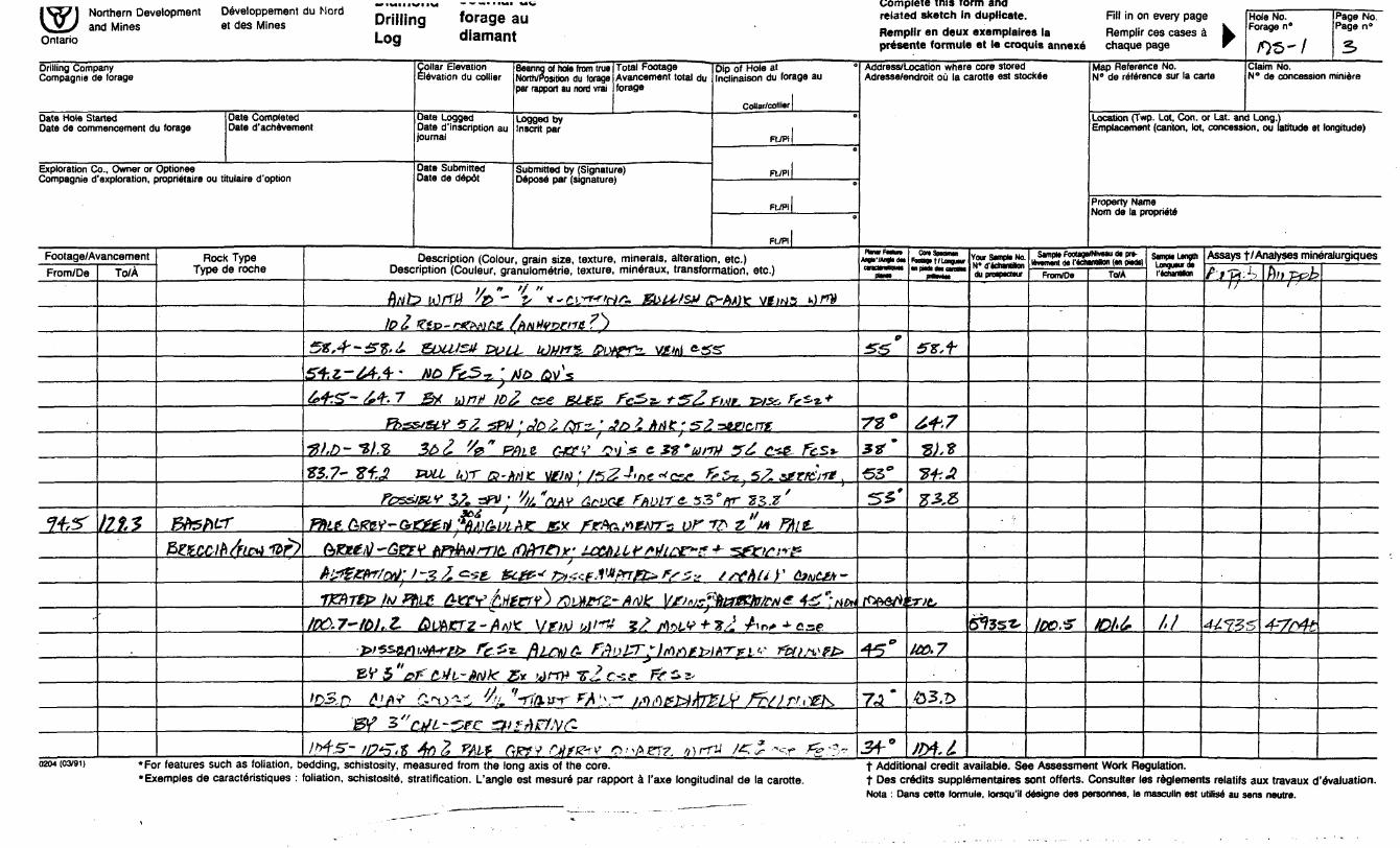
Description (Colour, grain size, texture, minerals, alteration, etc.) Description (Couleur, granulometrie, texture, mineraux, transformation, etc.)
/O^DfLV) gZZ&fi) y^2XD(^#M0Kil2..fZfc:AL'rt*\rn*
i^^mj&yxzf^': *r.^f-SfV QDhZTz, /JAiTz
MD ti ft A A/iE- "flu, , Uf&Kij jplfS? "* P'j'&s&tyflfyTEp
z^ xz&crfc *2rtALL.v S
\*S,7-n,7 flteWY ^\
s? JD/J^ UWrte-'Fyt^.ae'jFr.t&eAur6*uAerz.-Adarz77K v&ti^ te*. fa "-3*3 h.f Wa&tri/rr&xkjgZie&ce^'ZZ CszF*S^ LDCMl'S rsrt'tfl'rKfyrS3* hi Y*Ms'
Iffitfcfre 4?" ' -' ;* -TT? J"A ^3 *-7^ " u^tiy /f- z l fes?
37,7-2*7.*- .tmiwrfti*]?'- Mn srzv&nKZ i)S)fzut
A+.z-te.'S Mfizf^ m2S.D - 3^. 3 L i^^/'T/?}
t-Zt,*-**-.? tit*g*Z~' 2 *~~ j?'~7' "? f-v, ,, , , * t l.^r ^^X ' -^ -^ *' *-*-~ J*^ -? it-- A irff/i
C&rrfcrejnOAnc
vi-M ts. ticsf CM
i- C~v &V i-s 'A'torrW l^, -Z /^.^ * ,4/ *
^ * tiswrr^^ HSA-^L^' zrrw/z FMLT"TV fi f ' t.gffST' fa CUt ̂ C-&-3C-&
B /ODf^PT^ fiflicfKfTS:. l/fJ/.j fitrfJ- L&f&tKG'*— , f "^ &F'"
i
-iZ,f- 43, D ^ " -^ 'W j)V s/^-f " /,1/rV /*?/ C-;?~ F)^ ^ 5-4g,7^'?4-,cr Fos^'&is, l?
Isz.o-S+t- -?e Z FA, j r.
tytocjj&ft-s, Z-wf
^ y ^ t, c, ^-, * , t ^ ^7 J,^ ^rar fr s^^
Address/Location where core stored Adresse/endroit ou la carotte est stockee
fa/ZQ-^Jd-^ ^fc^
0H}fs
Planar feature AngM'/A/iglA das caractamtiauea
piams
•S5T3-75-'
^/*
Con Speomen Footage t /Longueur en fn&as QB3 cartxtes
X o ' r
^ Qr *S^*
^^
^o c
AS 0
O
tr^
?f,/.
* 7fZ,
4-5,b
55,3
Your Sample No. N" d'tosraition du prosoecteuf
1 Hole No. Page No. k Forage n 0 Page n"•T -^^ j : a
Map Reference No. Clasm No. N" de reference stir la carte N 0 de concession miniere
Location (Twp. Lot, Con. or Lat. and Long.) Emplacement (canton, lot, concession, ou latitude et longitude)
Property Name Nom de la propriete
Sampja Footage/Niveau ae pre- I6vecnem de i'6chantitton (en pisd^s
From/Oe ( To/A
Sf^fff
,, ,, ,, , , ., ,
^75-
Sample Lengtn longueur de
J. o'
Assays t /Analyses mineraiurgiques
An Av ^^i
,4^
0204(03/91) .por features such as foliation, bedding, schistosity, measured from the long axis of the core. t Additional credit available. See Assessment Work Regulation. •Exemples de caracteristiques : foliation, schistosity, stratification. L'angte est mesure par rapport a I'axe longitudinal de la carotte. t Des credits supplementaires sont offerts. Consulter ies regfements relatifs aux travaux devaluation.
rf-sw— - f~\ r v\if~f'^ \i trin) r^ ,,iv- N \^ -- Nota : Dans cette formula, lorstau'il desiqne des personnes, le mascuiin est utilise au sens neutre.SPV^i^UOCJZ. VZw HA'K^.'VraoTr C.^^^AJ^^ tf-^ ^ F"-?err?
42A01NE2049 2.26078 MORRISETTE 020

twill! QIIU
i -IT i — -— — .-..r . . ---—rr......... — ..W.W, nrillirm foraae an related sketch in duplicate. Fill in on every page Hole No. Page No. VV^ and Mines et des Mines J".limg ^^^ Remplir en deux exemp.aires la Remp.ir ces cases a L Forasa "' Pa9e "' Ontano 9 presente formule et le croquis annexe chaque page r ^w — J* 4
Drilling Company Compagnie de forage
Date Hole Started Date de commencement du forage
Date Completed Date d'achevement
Exploration Co., Owner or Optionee Compagnie d'exploration, proprietaire ou titulaire d'option
Footage/AvancementFrom/De
33. CTo/A
74.5-
Rock Type Type de roche
S'fashl-'
(P^l^tOfZ^
i.
1
Collar Elevation Elevation du collier
Date Logged Date (^inscription au journal
Date Submitted Date de depot
Bearing of hole from true Total Footage Dip of Hote at " North/Position du forage Avancement total du Inclinaison du forage au par rapport au nord vrai forage
CoHar/collierLogged by " Inscrit par
FUPi
Submitted by (Signature) Ft ,P, Deposd par (signature) ———— ——— '- ' ——————— -
Ft/Pi0
Ft./Pi
Description (Colour, grain size, texture, minerals, alteration, etc.) Description (Couleur, granulometric, texture, mineraux, transformation, etc.)
Ffrisf. G&fAJ. L&tbLLV si*.hc.}iet-?tefe'crnz*^ TK ifti-UW'**)??'&X /M -
J
t-iwrizzx*-m TzKzt&xtftiZ&FVfn^';
f'
Address/Location where core stored Adresse/endroit ou la carotte est stockee
PlMVFMlm
pttm
Fbottgtt/LonguMr •n piM dM c*MH
Your Sampte No.
du prospsctBur
Map Reference No. Claim No. N0 de reference sur la carte N 0 de concession miniere
Location (Twp. Lot, Con. or Lat. and Long.) Emplacement (canton, lot, concession, ou latitude et longitude)
Property Name Nom de la propriety
Sample FootagafldvMu d* prt- Mjvamtm d* I'WiandSon Im owdsl
From/Oe TOMSmpto Langtti Longueur* f'AcnandNon
Assays t /Analyses mineralurgiques
0204 (03191) *For features such as foliation, bedding, schistosity, measured from the long axis of the core. t Additional credit available. See Assessment Work Regulation. •Exemples de caracteristiques : foliation, schistosity stratification. L'angle est mesur6 par rapport a I'axe longitudinal de la carotte. t Des credits supplemental sent efforts. Consulter les reglements relatifs aux travaux devaluation.
i Nota : Dans cette formule, lorsqu'il designs des personnes, le masculin est utilise au sens neutre.
• veil IWI l VI Complete this form andIWJ Northern Development uw/eiuppwiwiii uu uuiu nrillinn foraae au related sketch In dupHcate. RI in on every page Hole No. Page NO \3J and Mines e, des Mines "filling S6 .3" Rempl.r en deux ex.mp.aires .a Remplir ces cases . F **"' **" Ontano L09 Qiamant prisente formule et le croquls annexe chaque page T /r)^-/ 3
Drilling Company Compagme de forage
Date Hole Started Date de commencement du forage
Collar Elevation Elevation du collier
Date Completed Date Logged Date d'aehevement Date description au
Journal
Exploration Co., Owner or Optionee Date Submitted Compagnie d'exploration, proprietaire ou titulaire d'optkm Date de depdt
Footage/AvancementFrom/De
Cf+tf
-
To/A
/2f,2
Rock Type Type de roche
BfrsfttfBlzcofi/fiiWr?
Beanng of hole from true Total Footage Dip of Hole at North/Position du forage Avancement total du Indinaison du forage au par rapport au nori vrai forage
Collar/collmLogged by Inscrit par
RTPiq
Submitted by (Signature) Fl /Pi
FtJPIo
FIVPI
Description (Colour, grain size, texture, minerals, alteration, etc.) Description (Couleur, granulometric, texture, mineraux, transformation, etc.)
;/ " f/ " /7/Vt? idfT/j fa " V* * ~ 2.i~fr'rfrjrt' IZbit'tStf @~AA)ie vtifjs *0f#
106 ^iu-^VVJAK fANtfV!yWfZ ,)
SX,*-*^,^ &1U1Z* cvu, WITS, towrn. VJSMI frjss-S+z-JA*' NO /5^5^ ',
s6*4-.^- 64-* 7 B* tint ID/
*to /pvs
? cse BLfg, fvSs'-t-^Z.rMr fris*, frz.*.*
Fbs&stV 52 'SPtf ' Jo Z /Or^ ' ^/o ^ A fi C ' s Z ^6f)c,nt
Z5.7- Zf,M tvLi kyr G?-A
PC'S&lR'f SA r^V 'Xsd *
/
'f '
rA/K MfJH ' /fs2-t'*e *w t*Z~ 5^ sfT^Tt
'fa'nAY A*tX*. fAMTe. 33 efiT -2?,.?'i/ TOAJC SK ftrAatffArr-; ofrfr z, M PMt-
(Ofr7f))f' J-CC&lif fitfL^F*? -f- "SfrtfsrpS
-n&Tf&ivFbip. AxxvAm?crr") saix*fz-AM Vfins^teaKbiMe. 42*: M*./fiO.7~ffiJ,,Z- fbVhKTZ-' fltf^C VfJuJ blt'ftt Z? foLV + Hs, -Aioif -*- c&e
frt^^1if}i.'W*f'tfr ff.'Sft ~ ftL^Z r-AuZTrlrtMWKTvLV T&tsvrt*
W S 'W' z*tL-Wk E* ^nv *s2 c*e. fct**'
'ff&irr fy \~ MfiP&ArZUr' /^//^,^KJh TT-, ft
15tf 3 C-)JL 5PC Z& ff\itfN(^-
VrfS' tP'S'it 4f)Z VAt-f CrKyy Mf&rV O-'^ET?, /y)rr~iJ /*Z Z --sr- fy'^-
Address/Location where core stored Adresse/endroit oil la carotte est stockee
cmMMquM (MM
tt*
rv*** 935"
5^5'
/^fVS/^J
^"
7J*
Jf 0
- Omananm
tt,f
6+J
-8), t 2*3
#-3,5
U0.7
tolfr
Jtti.t*
Your SmpH No.
dupmptctwr
6^3sz-
Map Reference No. Claim No. N" de reference sur la carte N" de concession miniere
Location (Twp. Lot, Con. or Lat. and Long.) Emplacement (canton, lot, concession, ou latitude et longitude)
Property Name Norn de la proprieW
SampM Foottgert*mu di prt- Ummnt d* I'MwHtton (m oMil
From/De
IDO.X
ToM
JDt'6
SampH LengOi Loigiwrdt rfchrtfcn
/,1
Assays f/Analyses mineralurgiquesf't"p-^
li
44733
hit pc?}?t '
4--7f~tft
0204 (03/91) *For features such as foliation, bedding, schistosity, measured from the long axis of the core. t Additional credit available. See Assessment Work Regulation. 'Examples de caracteristiques : foliation, schistosity, stratification. L'angle est mesure par rapport i I'axe longitudinal de la carotte. t Des credits supplementaires sont offerts. Consulter les reglements relatifs aux travaux devaluation.
Nota : Dans cette formule, lorsqu'il designe des personnes, le masculin est utilisd au sens neutre.

iNVI Northern Development ueveiupptiiiieni uu IMUIU nrillinn foraap au related sketch in duplicate. Fill in on every page Hole No. Page No. VsS; and Mines et des Mines ^"'""9 Wraga ,ail Remp.ir en deux exemp.alre, la Remplir ces cases a k ""- "' Ontano L09 aiamant presente formule et lecroquis annexe chaque page T fig-/ -f-
Drilling Company Compagnie de forage
Date Hole Started Date da commencement du forage
yollar Elevation Elevation du collier
Date Completed Date Logged Date d'achevement Date description au
journal
Exploration Co., Owner or Optionee Date Submitted Compagnie d'exploration, proprietaire ou titulaire d'option Date de depot
Footage/AvancementFrom/De
li?, 5
/6te
To/A
&4-S
237-?
Roct Type c
(Type le roche
A/rKSl^
5/teA^T"
BftG&A
i
Beanng of hole from true Total Footage Dip of Hole at " NorttvPositJon du forage Avancament total du Inclinaison du forage au par rapport au nord vrai forage
Collar/collierLogged by " Inscrit par
FUPi
Submitted by (Signature) n /pi Depose par (signature) -. . ————— -^- ——————— -
FUPIO
FITPi)
Description (Colour, grain size, texture, minerals, alteration, etc.) Description (Couleur, granulometric, texture, mineraux, transformation, etc.)
f)3J-n3,S ft,*zuL,l, M if? /2-ADV if*jAi jJ/TW^/^JW^sc
r&Si*
tyD.O-LJL.D VfU&f)-- f&ff I'/^A^KO ' tt&CJTlS tJi&tfiy hifElZFj.
ItirfH •S'^/^-^tFHtoGJOitfXD MbttMf
CbtiTht! *-)ZSt.Z '"S&JS&fL
' S
\Jlfdh]S "f ^ Sr ^Sf StZ-'^l* TjJjE&tZ&M&tJf
/Djf^/y/tl ^.K'ff'ft"1" Gj^ftf. Ir^fctLr*** l*} /TV-*
s
StfaZf H&UJ0& CcftT/lCfSNA+.Ofai) ftl~ #Z,*'rtDH fthfcNtrtfLt 'iftnH CfttfL
P& bSbVg' BUT ItidPKM 'UALV AiT^r^X^ T&ttti^iS Sftore. Z&Mte
T* tff~)ZKtx*ili*fb-K5tZwusrv /?L*erz* ^mZtejt ^S-\jAir^^y ^eAft^ff*irs /y^ rt?xrTrgxp' w^rj foteN&nt,' tiMtv flPaiKt*-
PrrtJ? ' '
ffi^-ltf,7 1 k* Hue &P 6)jfi?r Z? \teM urfp ^-^fcstfo'-Aft^ Fe.^
ftilftfffATflV t*!?L #t,\#I
ftZ,2-~ ftl. ? A&2, TfiH fi
/rer.s--/*^ -^-^e-t/:MiMeM.itt.* VMJ
/9A4-/FZ, l rvrrLL jlu&n
> ZP 1.2.' fif fT.Sts. f- fc -S 2- ^ ̂ 'i "-0 //l* ,
!V "- " ^ZCSe-^^r fe-LrtuXU^
^ZfV.*Jb2. c" *' ,'*1 V)CrZ. [///;V* * ̂ 2 05*v^- 5?
Ift) .^- /ft- b ff&Z mLJL &V O Ml).-** tifflt 'sZcz.e- ff^t.
Address/Location where core stored Adresse/androit ou la carotte est stockee
^(•^"(•4"
38*
4-3"
*t*
0
6-3*
^*
^5*57*7fi'
ConSpKmn
frttaj"*"
U3 J
Jtf.Z
lAKS
y y ^A ^^~ f^^ffjt
fit,*-
1*853
m.L/JSg
Your Sanpl* No.N- d'Mwittton au pnapacttur
i
N" de reference sur la carte N* de concession miniere
Location (Twp. Lot, Con. or Ut. and Long.) Emplacement (canton, lot, concession, ou latitude et longitude)
Property Name Norn de la propriete
Samprt FootagWNivMU d* prt- Itvmenl da r*dunt*jn (w oMsl
From/De To/A
SanpWUngmLongunrdi I'Wmilon
Assays t /Analyses mineralurgiques
0204 (03/91) *por features such as foliation, bedding, schistosity, measured from the long axis of the core. t Additional credit available. See Assessment Work Regulation. •Examples de caracteristiques : foliation, schistosity stratification. L'angle est mesure par rapport a I'axe longitudinal de la carotte. t Des credits supplementaires sont offerts. Consulter les reglements relatifs aux travaux devaluation.
Nota : Dans cotte formule, lorsqu'il designe des parsonnes, la masculin est utilise au sens neutra.
1 tV 1 l"wll"c" 1 wvBiuKiiin." i^.o.uHH'niio"' "" '""'" nHllinn foraae au related sketch m duplicate. Fill m on every page Hole NO. Page NO. \VJ and Mines et des Mines ur.l.mg g 1 u flemplir en deux exemp.aires .a Remplir ces cases a L Fora" "' Pa*' "' Ontano L09 uittiiidiH presente formule et le croquis annexe chaque page T /ffc-- l *5
Drilling Company Collar Elevation Rmmm *i hoi. imm M.* Tntai Pnntano r.,- -i u-.- -i " A-'-' — -" — *- — — - —— — - —— ' -- "' Compagnie de forage
Date Hole Started Date de commencement du forage
Collar Elevation Elevation du collier
Date Completed Date Logged Date d'achevement Date ^inscription au
journal
Exploration Co., Owner or Optionee Date Submitted Compagnie d'exploration, proprietaire ou titulaire d'option Date de depot
Footage/AvancementFrom/De
JM?
To/A
•W-3
Rocli Type c
' Type e roche
PcxrtwrY
Beanng of hole from true Total Footage Dip of Hole at " North/Position du forage Avancement total du Inclinaison du forage au par rapport au nord vrai forage
Collar/colliarlLogged by " Inscnt par i
FI./P1 10
Submitted by (Signature) R ,pj 1 Depose par (signature) —— ————— : — ' ——————— -
R./PI 1o
FtVPl|
Description (Colour, grain size, texture, minerals, alteration, etc.) Description (Couleur, granulometric, texture, mineraux, transformation, etc.)
IftA'Z&O.'S 6c*J*TrtLt CH? QTL ,.irrV- Z&2 C&* f&Sz-
Jct-.A-Ji&A &D2 " 'Alt. fi *-An. e W&LM
r*DLT Zertt
Jfr.S'-Ml fa?~ ASA
Ant zettejvori ^AAit&f&A *fa* MM /tftOAA
W, 3 '' * "
•f *' fi V if II
&CO&& e Jix*3 4 ^ 4 to. 5- : -wBPA)6r
fcS-L, M W: /i w 0rz-C#L*-tvM, MlTS,
ItrtC./tn f^KUT FZG**t!St't 5^ STH
fitoisr" * '
Jft.f -Jj/,3 *5*eAc vent, -ALL C#! **efr* AN*, -f /A^A* fs~-*
3A),2 -^3/.^ MUt- DL)MZ~
toer5feLSf-s ] nor /OJ&.^JS+S- fezhnrrz 2.
Gttffl'.Kfaa GDkzrz-'#2. t** fas? /x)r s
JtH- SA**^A
:^AJfi M /rf 4*2 fftit- QofiXr* *Jbtte?fr5't'
J3+Z W&Stirtint fAMT f* 6" " tvu. *W]7Z Bw+isif Amur*js+.f-te'?.? (M~ ^ -jwrr Ft** ^r or?-fokw*-F*vc*rf* f^r/^i
veufte f&Tfrbx w*Afcpywfr^Ass;jteKi AkP*
J??? '//A"eL*t /lev** **ML
T'C-V r Jr l '/z "mn cxtf &VK&T * &S, fa "x&ciCPffi', t* Ffttf, Vguc*) - AKfjFjo 3irtr!a mt-o
^r*e ;' ito'sw * fitanknMfn,rf
*?I?.3 s^t" MfaWtfii. tDtfTfc-r
Address/Location where core stored Adresse/endroit ou la carotte est stockee
PUrarFMun An^-lfcyj. ON anainmm
*m
*r&Tto*t*'
tt0tt*
*?S/.f
7(*fa*
ConSmomn FaougifUnguHr w pra an OOM
P**.
m*JD+,2.
J61.D
J/B.3,
JMA.J
JJ13
23*4*3*3
J&J
J&A
Your Sample No. N' d'*cfant*on du prospacteur
Map Reference No. Claim No. N' de reference sur la carte N 0 de concession miniere
Location (Twp. Lot, Con. or Lat. and Long.) Emplacement (canton, lot, concession, ou latitude et longitude)
Property Name Norn de la propriety
Sample FootaoMNiveau da ore- levament de l'4ctiam*on (en piads)
From/De To/A
Sample Length
I'eehantillon
Assays f 1 Analyses mmeralurgiques
0204(03/91) *For features such as foliation, bedding, schistosity, measured from the long axis of the core. t Additional credit available. See Assessment Work Regulation. •Exemples de caracteristiques : foliation, schistosite, stratification. L'angle est mesurS par rapport a I'axe longitudinal de la carotte. t Des credits supplementaires sont offerts. Consulter les reglements relatifs aux travaux d'evaluation.
Nota : Dans cette formule, lorsqu'H designe des personnes, le masculin est utilise au sens neutre.

1 *TV I '™ll "el " ueveiuH"""" L,ovB,uMMBintjiii uu uuiu nrillinn forpfip sil related sketch in duplicate. Rll in on every page Hole No. Page No. VV^ and Mines et des Mines Willing 9*?" Remplir en deux exemplars la Remplir ces cases a k, Fori*e "' Page n ' Ontario i-og uiaiuaiu presente formule et le croquis annexe chaque page T f^tt^l ^
Compagnie de forage
Date Hole Started Date de commencement du forage
Collar Elevation Bearing of hole from true Total Footage Dip of Hole at Elevation du collier North/Position du forage Avancement total du Inclinaison du forage au
par rapport au nord vrai forageCollar/collier |
Date Completed Date Logged Logged by " Date d'acnevement Date description au Inscrit par l
journal Ft./Pi |
Exploration Co., Owner or Optionee Compagnie d'exploration, proprietaire ou titulaire d'option
Footage/AvancementFrom/De
&IT.S
?3?,t5
rW/
To/A
W*
o"4 U
3ft.o
Rock Type Type de roche
S-fe^U-f
^r^vrf
5/ferV-rf&tervp&F
Date Submitted Submitted by (Signature) F, ,PI l Date de depot Depose par (signature) ——— - —— ̂ ^ ——————— -
FUPi jo
FL/Pi l
Description (Colour, grain size, texture, minerals, alteration, etc.) Description (Couleur, granulometric, texture, mineraux, transformation, etc.)
C#LP?"A-6?tiW'V extCClA-rri? GUFF - FA16 ilKez*) ZAzflLT* J-zJ/
^rf. FfSt.
-SAW* ftS ftS&VS
J37.Z -sHfrKP rifoozpds Cffftic-'
J4},! " CtfL ^Llf "
/OASSIV^ , "mg r-ZSV ISteArf ,"z H)G-Vi,*f iTAWCfX* 5V AKKr^rre-
Cifir?nt S*jr*Tfr q, "vfMSi} e-^ 0/*/^? lyft^i^ittM Mwfr-z
24-1. -f" ^ "G&fVng ftoiT te SmziriA
/4J. f "J+^.P " GrtTVrrZ /7p 2^*3*2 fi*K- Vixtrr? : ff&se. fez
MZA-Jtf'.? - /DAsstVJL fe^} cse ̂ 2^ fTz5*-, 5V 6t3r^'-r#}
teZfaKgariL-QnAtr*J&0- Jsu Sd^ *M*sue Z5& fez *Jt&X-Js?.) &IXUS1/ M/f wrre, AMisrz'fritlc MfejrvJ^/^ WZLA? bcvbZ fAD&r iM^S&IAT&v t&MXAeo &V*
rzzce&e^ tzr /"&ULUS/J XVLL IM/VB. p'Jh#r^~MK. V^/MSMM tlcs&jJtoiYe&z,
/ty.z.s fa"dLhf GtxjGe FtiL&r MiO, fou-tyjzp* gy/'-steArSseif****'(*3Zcsc. EUZE. fe-s*
Mx.7~4tf.4' K2fr*L BJ&, F^v *3"suu,z* a-Afc van
Adresse/endroit oil la carotte est stockee
ntnvFmun AngHVAngk IM arKtMMMi
(On,
MS4-**
97*
tt*
*-6j0
^*
M'
/ot-*
4*'
^B
fnr'
CortSpKimtn FoouqiT/Longwur mpiMidncvoaw
prMirtM
ten341)
JUX)M*-rJW
JrtfJ5U
j&'l
Ml,*
*fcX3
MM
Your Sample No. N* d'achantillon du prospect**
^
Sfsr*
s&st
M 0 de reference sur la carte N0 de concession miniere
Location (Twp. Lot. Con. or Lat. and Long.) Emplacement (canton, lot, concession, ou latitude et longitude)
Property Name Nom de la propriete
Sampla Footage/Nimau da pra- Mmmant da I'achanolan (an piads)
From/De
J&+
JSbX
To/A
W?
J&te
Sample Length Longueur da 1 flChflnMon
i,t'/,o'
Assays t/Analyses mineralurgiques
tfjxf?"
o?/?
-f-?7
0204 (03/91) .For features such as foliation, bedding, schistosity, measured from the long axis of the core. ' t Additional credit available. See Assessment Work Regulation. •Exemples de caracteristiques : foliation, schistosity stratification. L'angle est mesur6 par rapport a I'axe longitudinal de la carotte. t Des credits supplementaires sont offerts. Consulter les reglements relatifs aux travaux o" evaluation.
Nota : Dans cette formule, lorsqu'il designe des personnes, le masculin est utilise au sens neutre.
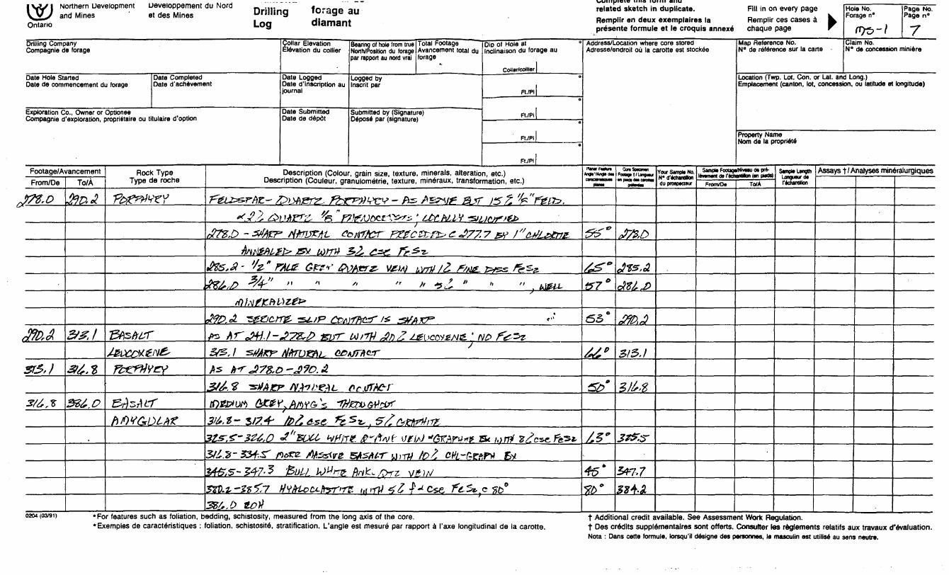
ixxnpieie mis torm anal \-y l Northern Development ueve.oppeii.eni au NUIU Dri|||no foraae au related sketch in duplicate. Fill in on every page Hole No. Page NO. V^/y and Mines ' et des Mines ""'""3 ^ " " Remplir en deux exemplaires la Remplir ces cases a L Forage "' Pa9e "' On I0 " presente formule et le croquis annexe chaque page r fjy^ -j -^
Drilling Company Collar Elevation Compagnie de forage Elevation du collier
Date Hole Started Date Completed Date Logged Date de commencement du forage Date d'achevement Date d 'inscription au
journal
Exploration Co., Owner or Optionee Date Submitted Compagnie d'exploration, propriataire ou titulaire d'option Date de ddpot
Footage/AvancementFrom/De
JTt.0
3fo,A
ST5,)
3/6, -5
To/A
to* A
&&J
3t6.t
326,0
Rock Type Type de roche
T^^veT
J&tiStftsT
XftJ^X^f^/V^'
72^/frY
e^^*^/*^/! t,/
A vO tf/* 1 ^ / A^^
Bearing of hole from true Total Footage Dip of Hole at ' North/Position du forage Avancement total du Inclinaison du forage au par rapport au nord vrai forage
Collar/collierLogged by Inscrit par
FUPi
Submitted by (Signature) f. ;pi Depose par (signature) —————— - —— 1 ——————— -
FtJPIe
Ft./PI
Description (Colour, grain size, texture, minerals, alteration, etc.) Description (Couleur, granulometric, texture, mineraux, transformation, etc.)
^eiz^rfa- fciMsrz. fhrrtiwt-frs. Azr\if &JT if Z 'k" ten*.*f1 A* MlfTZ, 'fa " FVfAXXX'&r-s ' H* NLlX TSlt ir*n*fto
r#Tg,S -ZtfAZF' rifrUZAL A
fatWLtb' sx umi .&S.A- 'k* FHUS. Gfv* 0\
#Z6,D 3*4-" "
/•s *i*f4^^t l*^^4f /** ^^^"f^**- ^ v"7^^ "7 ^^J 3 t ft ijj **^*rxjfyy/TC-i rZ^-C- i^uix^ c- *s/ /, s ^t? s c^ri^frfs.
Z2, Z*tL rr&t.
)HcrZ' UfW LWiJ/2 /fcufc rvss f^&s.
" * ^^ * " " usu.rf))tifK-Pi\MZ**
29D.oi *sfX)C-rrE' sti.tf3 CDA
#z Arj+j.l-JT&p firr
3/2, 1 SfJAKF flffTDISftL, G&i
}TKzri* Z&AKT
w '/7H 4nZ ̂ ( W2M& ' NO fe^J
fJTfivr
As trrJ)7Z,D~J?O.A
3/6. ̂ TstfAxy /VAffc^i, PC (/TAC~r
/OJ25f U^ &Z& r\ Aft Y Gf k "^tex* 6tf;W
S \, ^ttettfVlT?.
3lS".Z-S24,O J''fUU- WiTZ fi" fat VfisJ "GKAPV*? S* MTff ?^cse7fe5*3163- 53?^ f)*re- AfizsdrZ
26t?iS- .547- ^ '&LH-L W^rriZ.
B#sfieru,iv tot c*fc-AwPM Evfa^/Zrz v*W
52tli- — J? 5/7 Wl?frl*oCJ-tryT''fT?. tijiiTJ *yfc r^Cze, "fc^v c fib0
386.0 toti
Address/Location where core stored Adresse/endroit oil la carotte est stockee
FlnvFMun
cvtcMnHquM
tt"
t&E?
#7*
255 0
66'
0
/.S*
45*
W
ConSpKiiNn ftxngtt/Longu*.
•*rtT*"
J7&D
ifts.A
aM6J
3fo.3
315,1
21^8
3^.5-
5*7,7
32^2
Your SampK No. N* D'echanHlan
Map Reference No. Claim No. N" de reference sur la carte N" de concession minttre
Location (Twp. Lot, Con. or tat. and Long.) Emplacement (canton, lot, concession, ou latitude et longitude)
Property Name Norn de la propridte
Sampw FootagaMwau de prt- lemmnt M 1' fchanttlon In owBI
From/Oe TO/A
San*** LengthLongueur d* I'fcramnion
Assays f /Analyses mineralurgiques
0204(03/91) *For features such as foliation, bedding, schistosity, measured from the long axis of the core. t Additional credit available. See Assessment Work Regulation. *Exemples de caracteristiques : foliation, schistosity stratification. L'angle est mesure par rapport d I'axe longitudinal de la carotte. t Des credits supplemental sont offerts. Consutter les reglements relatifs aux travaux d'evaJuation.
Nota : Dans cette formule, lorsqu'il designe des personnes, le masculin est utilise au sens neutre.

RECEIVEDAU6 O 7 2003
GEOSCIENCE ASSESSMENT _____OFFICE

Swastika Laboratories LtdEstablished 1928 Assaying - Consulting - Representation
Geochemical Analysis Certificate 3W-2507-RG1Company: M. SUTTON Date: AUG-05-03Project:Attn: M. Sutton
We hereby certify the following Geochemical Analysis of 4 Core samples submitted AUG-01-03 by .
Sample Au Au Check Zn Number PPB PPB PPM
59351 146 -59352 46835 4704059353 525 49759354 219 -
Certified by-
l Cameron Ave., P.O. Box 10, Swastika, Ontario POK l TO Telephone (705) 642-3244 Fax (705) 642-3300

FORM 105 HEATH 81 SHERWOOD DRILLING (1986) INC.FORAGE HEATH 81 SHERWOOD (1986) INC.
DAILY REPORT - Rapport journalier
CONTRACTOR'S TIME/temps de ('entrepreneur Included in the Drilling Rate/Indus dans le tarif de forage
Date.y.^:./:.-?.^..... .Shift.......-.'!.'..... .......Machine No.... ...tL'.i..............Heure de travail # de la machine
Drilling at...................... .................Hole Angle..................................Lieu de forage Angle du trou Overburden:Hole No. From TO Total ft/mWdu trou De A Total de, pd/m•...::1:............ .......G......... .....z:........ .....z........Hole No. From To Total ft/m
( , ' V 1 .................................Z.............. ...../..':......................:.h:........
Z..2*A#.tt..:JJ..——^# de meche Sorte pd/m
Shell No..................................... Type......................... ft/m................if de la cartouche Sorte pd/m
TIME DISTRIBUTION/ Distribution de temps
Drilling/Forage......................................'^... Rhr. .........'f............... Mhr
OverburdenMortterrain............................'....Rhr..........":'.'............... Mhr
Moving7Deplacement....................,...............Rhr...........................Mhr
Walking Time/Tempsdemarche. . . . . . . . . . . . . . . . . . . . . . . Rhr. . . . . . . . . . . . . . . . . . . . . . . . . . Mhr
Repairing/Reparation................... ..................Rhr.......................... Mhr
(What?WQuoi?l.................................................................................
Other/Autre. . . . . . . . . . . . . . . . . . . . . . . . . . . . . . . . . . . . . . . . . . . . . . . . .Rhr . . . . . . . . . . . . . . . . . . . . . . . . . . . Mhr
(What?KIQuoi?l.............................................................................
Casing Placed in Hole/ Tubage placer dans le trou:
AW BW NW HW
2'..............................................,............
ft 5'..................... ......................f...............
10'.........................................................
Casing Recovered/Tubage recuperer: AW BW NW HW
2'...........................................................
5'...........................................................
10'................................................-........4 ;
RUnner^Perateur...^^{..^f:.rl...^r.^. ;f.^.....Y.^..............Hrs
Runner^perateur.........................................................................Hrs
H.IP.rWssistant...^,U.L^........^:l^.^..^.....L^...............Hr.
Helper/Assistant.......................................................................... Mrs
Other/Autre................................................................................. Mrs
COMPANY TIME AND MATERIALSTemps et materiels de la compagnie Time Distribution/Distribution de temps
Drilling/Forage....... .............................................Hrs................... Mhr
Overburden From/Mort terrain de. . . . . . . . . . . . . . . . . . . . . . . .TO/a.
Bit No...................................... Type................. ft/m........................# de meche Sorte pd/m
Shoe No... .................................Type................... ft/m......................
Shell No. ....................................Type.................... ft/m....................# de la cartouche Sorte pd/rn
MovingyDeplacement.....,......................................Rhr.. ......... . Mhr
Pulling Casing/Retirer tubage. . . . . . . . . . . . . . . . . . . . . . . . . . . . . . . . . . . .Rhr.. . . . . . . . . . . . . . . Mhr
Cemented At/Cimenter a......... ...............ft/m.... ........Rhr............... Mhr
Cement to set/Durcir le ciment..................................Rhr......... . Mtir
Drilling Cement/Forage du ciment . . . . . . . . . . . . . . . . . . . . . . . . . . . . . .Rhr. . . . . . . . . . . . . . Mhr
FronVde...............................TO7a..................................
Reaming (Hole Conditionsl/l'etat du trou............ .........Rhr.............. Mhr
Waterline At/Ligne d'eau a. ..^.'.-.-.'.'.h........ ..ft/m. ..(J. .'.....Rhr.... Vi....... Mhr
Survey Testing At/Assessment a...... .........ft/m. ...........Rhr............ Mhr
Acid Testing At/Analyse (acide)............ .....ft/m... .........Rhr............ Mhr :
Delays/Retard I......................................)................... Rhr............ Mhr
Walking Time/Temps de mar one................................... Rhr........... Mhr
Wedging At/Coincer le trou a........... ...........ft/m... ........Rhr............ Mhr
Other/Autre.................................................... ...........Rhr............ Mhr
(What?)AQuoi?).................................. ...............................
Materials Used, Lost or Damaged ^^
Materiels utiliser, perdu ou endommaaer: ^,
GENERAL REMARKS/Observations g6n6ral:
*
APPROVED BY: 7. ''J /', i 'l rf lApprouver par:
CO. REP. /' '' (, . .., , , - .-;. ,V//;Co. Rep.
FOREMANCoiilicni.iilir
Whita-OfflM/Blanc Bureau Ysllow-Co. Rep./Jaune-Co Rap

FORM 105 HEATH 81 SHERWOOD DRILLING (1986) INC.FORAGE HEATH 81 SHERWOOD (1986) INC.
DAILY REPORT - Rapport journalier
CONTRACTOR'S TIME/temps de l 'entrepreneurIncluded in the Drilling Rate/Indus dans le tarif de forage
Oat** "V -^/^Shift /W Y Machine No "? @JHpure de travail # de la machine f i —
Drilling at ~f''i ,' feJii^^trW^!? . , . . . . . . . Hote Angle ~ ^Lieu de forage fT^"^// , S Angle du trou Overburden: ' ' " -x y-, -QHole No. From ' To Total ft/m*du trou De A Total de pd/m
Hole No. From/ ^ To ^ Total ft/m
s v ^ 7 M3P ^ ̂ p
BitNo 4-77 ,X/ Type /^ ̂ ' C -^^ ft/m
Shoe No........... ..........................Type......... ................ft/m................
Shell No.. ...................................Type...... ...................ft/m................# de la cartouche Sorte pd/m
TIME DISTRIBUTION/ Distribution de temps
Drilling/Forage..................:... ............../.-'....Rhr..... .............^.7.. ..Mhr
OverburdenMortterrain................................Rhr........................... Mhr
Repairing/Reparation... ..................................Rhr.......................... Mhr
Casing Placed in Hole/ Tubage placer dans le trou:
AW BW NW HW
2'...........................................................
5'...........................................................
10'.........................................................
Casing Racovered/Tubage recuperer: AW BW NW HW
2'...........................................................
5'........:..................................................
10'.........................................................
"~~\ r l |YA \\ 4A. \ iHelperWssistant.............wr*..0--"-\----'------'''-V.'iX..:*)fX...^....l.i^t,.....Hrs
Helper/Assistant.......................................................................... Hrs
Other/Autrqr"................................................................................ Hrs
COMPANY TIME AND MATERIALSTemps et mate'riels de la compagnie Time Distribution/Distribution de temps
Drilling/Forage.................................................... Hrs...............
Overburden7Mortterrain.......................................Hrs..
Overburden From/Mort terrain de....................'....TOVa...............
Bit No...................................... Type....... ..........ft/m...............# de meche Sorte pd/m
Shoe No.................................... Type................... ft/m............
Shell No..................................... Type.................... ft/m...........
Moving^eplacement............................................Rhr. .............
From/deft...... .....................TO/aff................... Distance............
Reaming (Hole Conditions)/!' etat du trou............ .........Rhr..........
Waterline At/Ligne d'eau a.............. .........ft/m. ...........Rhr.........
Survey Testing At/Assessment a..... ..........ft/m. ...........Rhr.........
Acid Testing At/Analyse (acide)......... ........ft/m.. ..........Rhr........
Delays/Retard l.....,................................)...................Rhr........
Wedging At/Coincer le trou a........... ...........ft/m. ..........Rhr.......
Materials Used. Lost or Damaged
Materials utiliser, perdu ou endommager:
•r ^
\ .
lt\
i '
*y V'
V
1
Mhr
....Mhr
.... Mhr
....Mhr
.... Mhr
....Mhr
....Mhr
... Mhr
... Mhr
... Mhr
... Mhr
... Mhr
... Mhr
....Mhr
....Mhr
—i
\
GENERAL REMARKS/Observations general:.
APPROVED BY:-—- Approuver par; fWhtte-Of f lce/Blan c- Bureau '
./i J I CO. REP.Co. Rep.
Yellow-Co. Rep./Jaune-Co -Rep
\ /FOREMAN^ - : ConVemaTtre
Pink-Fore mbiVRose-Ccf^tremaitre

FORM 105 HEATH k SHERWOOD DRILLING (1986) INC.FORAGE HEATH 81 SHERWOOD (1986) INC J
DAILY REPORT - Rapport journalierJ 4 i b
CONTRACTOR'S TIME/temps de ('entrepreneur Included In the Drilling Rate/Indus dans le tarif de forage
Date/*?. X. .?^...... .Shift.. ..^\............ .Machine No.....^r??...............Wgure.de travail # de la machine ^^
Drilling at.... ..../...'...V.ff.................Hole Angle....... ~..V^T.............Lieu de forage - Angle du trou Overburden:Hole No. From To Total ft/m#du trou De A Total de pd/m
Drilling: Hole No. From To Total ft/m
Bit *~1 ff de rffeche Sorte pd/m
Shoe No................. ....................Type.. .......................ft/m................
Shell No..................................... Type......................... ft/m................tt de la cartouche Sorte pd/m
TIME DISTRIBUTION/ Distribution de temps
Walking Time/Tempsdemarche. . . . . . . . . . . . . . . . . . . . . . .Rhr. . . . . . . . . . . . . . . . . . . . . . . . . . Mhr
Repairing/Reparation...................... ...............Rhr.......................... Mhr
Other/Autre................................................. Rhr...........................Mhr
Casing Placed in Hole/ Tubage placer dans le trou:
AW BW NW HW
2'...........................................................
5 1 ...........................................................
10'.........................................................
Casing Recovered/Tubage recuperer: AW BW NW HW
2'...........................................................
5 1 ...........................................................
10'.........................................................
Helper/Assistant.,^^*?.......^
Helper/Assistant............................................................... .'.......... Hr*
Other/Autre ............................................................................... Hrs
COMPANY TIME AND MATERIALSTemps et materials de la compagnie Time Distribution/Distribution de temps
Drilling/Forage........................................
Bit No...................................... Type......# de meche Sorte
Shell No..................... ................Type.....# de la cartouche Sorte
Pulling Casing/Retirer tubage
...........Hrs...............
..........TO/a...............
...........Hrs................
.......'..TO/a...............
...........ft/m...............pd/m
.............ft/m.............
...............ft/m...........pd/m
.............Rhr..............
.......Distance............
...............Hhr...........
Cemented At/Cimenter a........................ ft/m............ Rhr...........
Waterline At/Ligne d'eau a.......................
Survey Testing At/Assessment a . . . . . . . . . . . . . .
Wedging At/Coincer le trou a...................
Other/Autre...........................................
Materials Used, Lost or Damaged
Materials utiliser, perdu ou endommager:
................Rhr..........
.................Rhr..........
TO/a........................
.................Rhr..........
ft/m... .........Rhr.........
ft/m.. ..........Rhr.........
.ft/m, ..'.i—rV. Rhr.......'.
...................Rhr........
....................Rhr.......
..ft/m.... .......Rhr........
...................Rhr........
... Mhr
....Mhr
...Mhr
....Mhr
... Mhr
....Mhr
....Mhr
... Mhr
... Mhr
.. Mhr
... Mhr
... Mhr
... Mhr
....Mhr
....Mhr
.
............................l..............................i
, i
T . \vr
\
fact P6fltV To BfZtk 6*r
APPROVED BY: ^ ̂{(jfc\~ —— CO. REP.Approuver par: Co. Rep.
,. . J
V \ * FOREMAN. Contr^maTtre
4 l ; ^Whlte-Offtee/Blanc-Bureau YvHow-Co. Rsp./Jaune-Co.-Rep

FORM 106 .HEATH * SHERWOOD DRILLING (1986) INC.FORAGE HEATH b SHERWOOD (1986) INC.f
DAILY REPORT - Rapport journalier
CONTRACTOR'S TIME/temps de 1 'entrepreneur Included In the Drilling Rate/Indus dans le tarif de forage
n Tt// y 2 '%-^sh-f i}/} 1/ - 2^~' 'Heure de travail # de la machine
Drilling at. ..IW.JC&J...J!...... ...........Hole Angle..................................Lieu de forage . Angle du trou Overburden:Hole No. From To Total ft/m#du trou De A Total de pd/m
Drilling: Hole No. From To Total ft/m
*i'Cr
*7 JT~ X Z/'X "-7 1 iJr6ri* f /* No..^...J..,r...^..S..~^.....,...........T'Ype.'!,.{(r...tr...f..fr.....ftlm...............9 de meche Sorte pd/m
Shoe No.............. .......................Type. ........................ft/m................
Shell No............ .........................Type.......... ...............ft/m................# de la cartouche Sorte pd/m
TIME DISTRIBUTION/ Distribution de temps
Drillin^Forage......................................yjO.Rhr.....................j?y^?hr
OverburdenMortterrain................................Rhr........................... Mhr
Walking Timefi"empsdemarche.......................Rhr..........................Mhr
Other/Autre..................................... ............Rhr........ ...................Mhr
Casing, Placed in Hole/ Tubage placer dans le trou:
AW BW NW HW
2 1 ..............................................:'............
5'...........................................................
10'.........................................................
Gating Recovered/Tubagd recuperer: AW BW NW HW
2'...........................................................
5'.............................,,............................
10'.........................................................
J '")R.Foreman/Contremattre op6rateur..^7..r*rrTf!^^..(^..............V..u^Hr*
Runner/Operateur.............. ............................................................Hr*
Other/Autre .. . ...............................................................Hr*
COMPANY TIME AND MATERIALSTemps et matdriels de la compagnie Time Distribution/Distribution de temps
Drilling/Forage........................................
Drilling From/Forage de............................
Bit No...................................... Type......9 de meche Sorte
Shell No.......................... ...........Type.....n de la cartouche Sorte
Pulling Casing/Retirer tubage. .
...........Hr*..............
..........TO/a.............
.....'....TO/a..............
...........ft/m..............pd/m
.............ft/m...........
...............ft/m.........pd/m
.............Rhr............
...............Rhr..........
Cemented At/Cimenter a... .....................ft/m....... .....Rhr..........
Cement to set/Durcir le ciment..................................Rhr.........\
Drilling Cement/Forage du ciment ....';.......
Survey Testing At/Assessment a..............
Delayi/Retard I......................................1
Walking Time/Temps de marche...............
Other/Autre...........................................
Materials Used. Lost or Damaged
Materials utiliser, perdu ou endommager:
.................Rhr........
.................Rhr.........
ft/m. ...........Rhr........
ft/m.......... ..Rhr........
.ft/m.. ..........Rhr.......
...................Rhr......
....................Rhr......
..ft/m..... ......Rhr......
...................Rhr......
Mhr
.....Mhr
..... Mhr
......Mhr
.....Mhr
.....Mhr
.....Mhr
..... Mhr
..... Mhr
.... Mhr
.... Mhr
..... Mhr
..... Mhr
.....Mhr
.....Mhr
*
rf t^r? /r ^4r.frl0 l/U*/^
^(2 ' /^Y fa /7APPROVED BY:Approuver par:
,h')^^*'
CO. REP.Co. Rep.
j/ ) JTZr? ? '' FOREMANContremaTtre
Pink. Fora man/Rose-Contremalt reWhlta-Office/Blanc-Bureau ..,' J*t-Y*llow-Co. Rep./Jaune-Co.-Rep
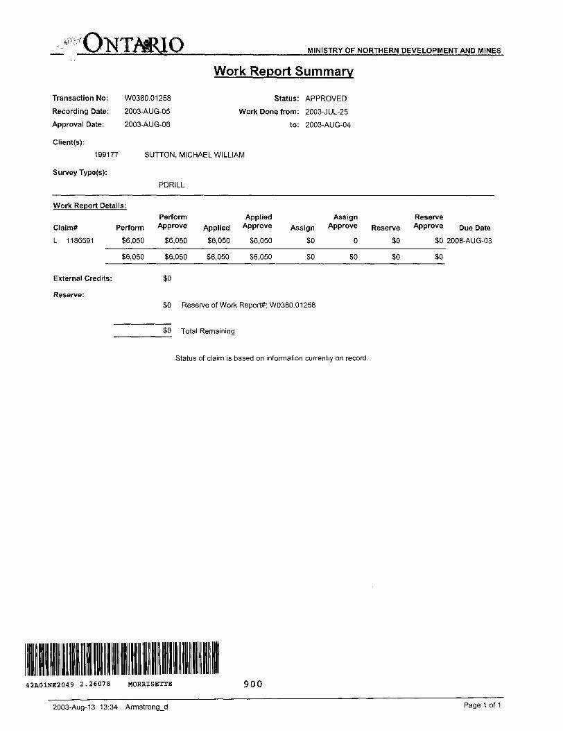
MINISTRY OF NORTHERN DEVELOPMENT AND MINES
Transaction No: W0380.01258
Recording Date: 2003-AUG-05
Approval Date: 2003-AUG-08
Work Report Summary
Status: APPROVED
Work Done from: 2003-JUL-25
to: 2003-AUG-04
Client(s):
199177
Survey Type(s):
SUTTON, MICHAEL WILLIAM
PDRILL
Work Report Details:
Claim*
L 1186591
Perform Applied Assign ReservePerform Approve Applied Approve Assign Approve Reserve Approve
36,050 86,050 -- ---S6.050 56,050 SO SO
Due Date
SO 2008-AUG-03
S6,050 S6.050 56,050 S6.050 SO SO SO
External Credits:
Reserve:
so
SO Reserve of Work Report#: W0380.01258
SO Total Remaining
Status of claim is based on information currently on record.
42A01NE2049 2.26078 MORRISETTE 900
2003-Aug-13 13:34 Armstrong-d Page 1 of 1

Ministry ofNorther i Developmentand Mines
Date: 2003-AUG-11
Ministers du Developpement du Nord et des Mines Ontario
GEOSCIENCE ASSESSMENT OFFICE 933 RAMSEY LAKE ROAD, 6th FLOOR SUDBURY, ONTARIO P3E 6B5
MICHAEL WILLIAM SUTTON BOX 534KIRKLAND LAKE, ONTARIO P2N 3J5 CANADA
Tel: (888) 415-9845 Fax:(877)670-1555
Dear Sir or Madam
Submission Number: 2.26078 Transaction Number(s): W0380.01258
Subject: Approval of Assessment Work
We have approved your Assessment Work Submission with the above noted Transaction Number(s). The attached Work Report Summary indicates the results of the approval.
At the discretion of the Ministry, the assessment work performed on the mining lands noted in this work report may be subject to inspection and/or investigation at any time.
If you have any question regarding this correspondence, please contact PIERRE DESCOTEAUX by email at [email protected] or by phone at (705) 670-5858.
Yours Sincerely,
Sheila LessardActing Senior Manager, Mining Lands Section
Cc: Resident Geologist
Michael William Sutton (Claim Holder)
Assessment File Library
Michael William Sutton (Assessment Office)
Visit our wcbsite at http://www.gov.on.ca/MNDM/LANDS/mlsmnpge.htm Page: 1 Correspondence 10:18575

42A01NE2049 2.26078 MORRISETTE 200
5?DOOOt
5340000N-—
msaam
67CCOCE 675000E
UTM Zona 17 6000m srU
Thosa wlstiino to dak* mining claims should consull with the Provincial Mining RBCordars1 Officn of the Ministry of Northern Davwapnwit out Minx tx additional General Infofmalion and Limitations Thh map may no! (how unraglttareil land tenure and intarests ininformation on tha status of tha lands shown h*r*on. This mat) is not intended for navlgBtlonal, survey, or land tit!* determination purpo*8s**thft Information Contact Information- Tot! Fnt* Map Datum: HAD 63 }*niJ indudfng certain patantB, l*as*ft, easamant*. right of ways,shown on this mie Is compilod from various tourcet. Completenms and accuracy ire not guaranteed. Additional Information may also tie obtained through the Provincial Mining Recorder*' Office- Tel: 1 (888) 416-9845 ext 57IMbiectian: UTM (6 degree) flooding rights, licences, or other forms of disposition of rights andlocal Land Titles or Registry Office, or the Ministry of Natural Resource!!. Willet oteen Miller Centre 033 Rwnsey Luke Roed Fax: 11877) 670-1444 Topoawohlo tola Source: Lend Information Ontario Mere* from the Crown, Also certein lend tenure end lend uses
Sudbury ON P3E BBS Mining Land Tenure Source: Provincial Mining Recorders' Office th!l1 "X*11* w P'ohlblt free entry to itoke mining claims may not beThe Information shown Is dinved from digital date available In the Provincial Mining Recorders' OWc* st the time of downloading from the Ministry of Northern Home Page: wviw.mndm.gov.on.ra/MNDM/MIN6S/LANDS/mlsinnp8e.htm illustrated.
t anr! Mln*ft WM* dtM
ONTARIOCANADAMIHISTR V OF HOHTHEKH MVtLOPMENT MUD MIMBI
PROVINCIAL MIHINOMooMHr* OFFICE
Mining Land Tenure Map
Date l Time of Issue: Men Aug 11 14:51:49 EDT 2003
TOWNSHIP/AREA PLAN MORRISETTE G-3217
ADMINISTRATIVE DISTRICTS / DIVISIONSMining DivisionLand Titles/Registry DivisionMinistry of Natural Resources District
Larder Lake TIMISKAMING KIRKLAND LAKE
TOPOGRAPHIC| j Administrative Bocndurtw
n
Land Tenure
PjTj
Mi Provincial Park
t"""l Indian Rmerw Uftmhi*i Patent
r,
A
Contour
Min* Shall*
Surface And Mining Hlghta
Surface Night* Only
Trail
Natural BM Pip**
UtHSMS
Tower
Surface And Mining Rights
Surf** msl* O*
Una Uis Purmll
OWer IB Connell (Not open lw i
! :: ...taw..BW Only MMne Claims
LAND TENURE WITHDRAWALS
,:|:[^^jt j ; j Areas WtUidl'aWn tram OteposWon
WmiWaWm
WVtt W.Wm
OnWf In OcwrnKI WKimmwal T
IMPORTANT NOTICE
LAND TENURE WITHDRAWAL DESCRIPTIONSIrnntltof Type Dill DeiOipllon
W 20/7* Wm W 20/79 Wtm W 66/80 Wm
Warn Wsm Wm w*
W-LL-P1821 Wsm
W.L.31/96
Jin 1,2001 Jun 1,2001 M.rS, 2001 Jan 3,1980 M.y 27.2000 Apr 27. 2000 Auj 11,1998 Out 27,1998 Aug 29, 2002
20/1 1 Me S.R O. 185464SECTION 36(80 MR W 20/70 S-3-7B SR 4 MR 160705SECTION J6/80 NR W 20/79 6-3-79 SR t MR 190708SECTION 36/80 NR W 50/80 3-140 M.R.0. 160705SEC.35W-1.-17/00 2000/05/27 S+M 105130Sac, 3S VV-L-19/00 2000/04/27 Mf8195160SBC. S6W4.-31/B* 11/08/96 MROSEC.35 W-L J6/08 OCT 27/88 S.R.0. 1651 SOen hrerlz" hltpv/w**.mndm.gov on.ca/MNDM/WINES/LAMDS.llvleB/b,
IMPORTANT NOTICES
ta und*r which special fttouiatlon, limitations or conditions ftxist that aff*ct n , staking *nd