Embed Size (px)
Citation preview

Development of master curricula for natural disasters risk management in
Western Balkan countries (573806-EPP-1-2016-1-RS-EPPKA2-CBHE-JP)
Report on established practices in EU countries for natural
disaster risk management (NDRM)
Project title Development of master curricula for natural disasters risk management in Western Balkan countries
Project acronym NatRisk Project reference number 573806-EPP-1-2016-1-RS-EPPKA2-CBHE-JP Coordinator University of Nis
Project start date October 15, 2016 Project duration 36 months
Reference no and title of workpackage
WP1 Analysis of natural disasters needed to be managed in Western Balkan regions
Institution BOKU, UNI, MU, UNIME, OE, TUC
Author(s) BOKU (Kurt Glock, Michael Tritthart)
UNI (Milan Gocić), MU (Sally Priest, Simon McCarthy, Josie Joyce, Emeline Matheou, Louise Story), UNIME (Giuseppe Aronica, Giovanni Falsone, Giovanni Randazzo, Ernesto Cascone), OE (Agota Dregelyi-Kiss), TUC (Georgios Stavroulakis, Vassilis Moustakis, Yannis Tsompanakis, Maria Bakatsaki, Magda Marinaki)
Document status Final Document version and date
v.01, 03/10/2017
Dissemination level Public
Project number: 573806-EPP-1-2016-1-RS-EPPKA2-CBHE-JP "This project has been funded with support from the European Commission. This publication reflects the views only of the author, and the Commission cannot be held responsible for any use
which may be made of the information contained therein"
Development of master curricula for natural disasters risk management in
Western Balkan countries (573806-EPP-1-2016-1-RS-EPPKA2-CBHE-JP)
Table of contents 1 Introduction .........................................................................................................................................1
2 Identification of natural disasters .....................................................................................................1
2.1 Austria............................................................................................................................................1
2.1.1 Natural hazards of alpine torrents .....................................................................................2
2.1.2 Avalanches .............................................................................................................................2
2.1.3 Mass movements...................................................................................................................3
2.1.4 Floods in large rivers ............................................................................................................4
2.2 Greece .............................................................................................................................................7
2.2.1 Earthquakes............................................................................................................................8
2.2.2 Tsunamis ..............................................................................................................................10
2.2.3 Fire.........................................................................................................................................10
2.2.4 Landslides and floods.........................................................................................................10
2.3 Hungary .......................................................................................................................................10
2.4 Italy ...............................................................................................................................................14
2.4.1 Earthquakes..........................................................................................................................14
2.4.2 Floods....................................................................................................................................15
2.4.3 Landslides or rockfalls .......................................................................................................15
2.4.4 Coastal erosion ....................................................................................................................17
2.4.5 Volcanic eruption ................................................................................................................17
2.5 United Kingdom .........................................................................................................................19
2.5.1 Flooding................................................................................................................................22
2.5.2 High temperatures and heatwaves...................................................................................27
3 Analysis of established risk management strategies ...................................................................27
3.1 EU .................................................................................................................................................27
3.1.1 EU Water Framework Directive........................................................................................27
3.1.2 EU Floods Directive ............................................................................................................28
3.2 Austria..........................................................................................................................................30
3.2.1 Deployment..........................................................................................................................31
3.2.2 Corrective Maintenance .....................................................................................................31
3.2.3 Reconstruction .....................................................................................................................32
3.2.4 Preventive Measures...........................................................................................................32
3.2.5 Precautionary measures .....................................................................................................34
3.3 Greece ...........................................................................................................................................34

Development of master curricula for natural disasters risk management in
Western Balkan countries (573806-EPP-1-2016-1-RS-EPPKA2-CBHE-JP)
3.3.1 Building and design requirements ...................................................................................34
3.3.2 Weather prediction .............................................................................................................35
3.4 Hungary .......................................................................................................................................35
3.4.1 Implementation of the Floods Directive ..........................................................................35
3.5 Italy ...............................................................................................................................................36
3.5.1 Hazard information for seismic classification ................................................................37
3.5.2 River Basin Hydrogeological Plans and implementation of EU Floods Directive ....38
3.6 England ........................................................................................................................................38
3.6.1 Prevention: Spatial planning and development control................................................40
3.6.2 Protection measures: Flood defence and mitigation......................................................42
3.6.3 Preparation, awareness-raising and resilience ...............................................................43
3.6.4 Response and crisis management .....................................................................................45
3.6.5 Recovery and reconstruction .............................................................................................46
4 Analysis of responsible institutes ...................................................................................................47
4.1 Austria..........................................................................................................................................47
4.1.1 Federal administration .......................................................................................................48
4.1.2 Provincial administration ..................................................................................................49
4.1.3 Municipal administration ..................................................................................................49
4.1.4 General public......................................................................................................................50
4.1.5 Media ....................................................................................................................................50
4.1.6 Insurance companies ..........................................................................................................50
4.1.7 Science and standardisation institutes .............................................................................50
4.1.8 NGOs ....................................................................................................................................50
4.2 Greece ...........................................................................................................................................50
4.2.1 Civil protection agency ......................................................................................................50
4.2.2 Weather forecast and warning ..........................................................................................51
4.2.3 Organization for Aseismic Design and Protection.........................................................51
4.3 Hungary .......................................................................................................................................51
4.4 Italy ...............................................................................................................................................53
4.5 England ........................................................................................................................................53
4.5.1 National management ........................................................................................................56
4.5.2 Local-level management ....................................................................................................57
4.5.3 General public......................................................................................................................59
4.5.4 Private market actors: Insurance companies and water companies............................59
Development of master curricula for natural disasters risk management in
Western Balkan countries (573806-EPP-1-2016-1-RS-EPPKA2-CBHE-JP)
4.5.5 Media ....................................................................................................................................60
4.5.6 Other organisations.............................................................................................................60
5 Assessment of risk management aspects.......................................................................................60
5.1 Austria..........................................................................................................................................60
5.1.1 Advantages ..........................................................................................................................60
5.1.2 Disadvantages......................................................................................................................61
5.1.3 Knowledge gaps ..................................................................................................................62
5.2 Greece ...........................................................................................................................................62
5.3 Hungary .......................................................................................................................................62
5.3.1 Advantages ..........................................................................................................................62
5.3.2 Disadvantages......................................................................................................................63
5.3.3 Knowledge gaps ..................................................................................................................64
5.4 Italy ...............................................................................................................................................64
5.5 England ........................................................................................................................................65
5.5.1 Advantages ..........................................................................................................................65
5.5.2 Disadvantages......................................................................................................................65
6 Analysis of EU master curricula .....................................................................................................66
6.1 Austria..........................................................................................................................................66
6.2 Greece ...........................................................................................................................................67
6.3 Hungary .......................................................................................................................................67
6.4 Italy ...............................................................................................................................................67
6.5 United Kingdom .........................................................................................................................67
7 Literature ............................................................................................................................................68

Development of master curricula for natural disasters risk management in
Western Balkan countries (573806-EPP-1-2016-1-RS-EPPKA2-CBHE-JP)
1
1 Introduction
Information about established practices for natural disasters risk management in EU countries is indispensable for developing master curricula for risk management in Western Balkan regions. In work package 1.2 (WP 1.2) a collaborationbetween BOKU and all partners from EU countries is foreseen to close the knowledge gap concerning natural disaster risk management. In the following chapters information about natural disasters, analysis of risk management, survey of responsible institutes and analysis of education possibilities are documented for different EU countries.
2 Identification of natural disasters
In each country the development of risk management practices is correlating highly with the types of natural disasters occurring there. In the following chapters overall statistics and relevant natural disasters are presented for each EU project partner. These data sets have been the basis for establishing practices for natural disasters risk management in these countries.
2.1 Austria
Due to the fact that approximately two thirds of the Austrian national territory account for alpine regions, the greatest natural hazards are related to mountains. A distinction is drawn between hazards of alpine torrents (e.g. debris flows or floods) and avalanches. Additionally, due to geological conditions, mass movements like landslides or rockfalls are repeatedly occurring in Austria. However, the highest damage potential is related to floods in large rivers, like Danube, Drava, Inn and Mur, crisscrossing the alpine valleys as well as the hilly and flat regions in the north-east of Austria (Interpraevent, 2009). A ranking of natural disasters was defined by Rudolf-Miklau (2009) considering personal risk, damage risk and disaster potential.
Table 1: Ranking of natural disasters in Austria (Rudolf-Miklau, 2009)
Position Type of natural disaster Personal risk Damage risk Disaster potential
1. Flood Medium Very high Very high
2. Avalanche Very high Medium High 3. Storm (hurricane) Medium High Very high
4. Earth quake High High Medium 5. Debris flow High Medium Medium 6. Landslide High Medium Medium
7. Rockslide Medium Medium Medium 8. Forest fire Low Medium Medium
9. Heavy rainfall (hail) Low Medium Medium 10. Rockfall High Low Low 11. Thunderstorm High Low Low
12. Snow pressure Medium Low Low 13. Drought Low Medium Low
14. Frost Low Low Very low

Development of master curricula for natural disasters risk management in
Western Balkan countries (573806-EPP-1-2016-1-RS-EPPKA2-CBHE-JP)
2
2.1.1 Natural hazards of alpine torrents
A total number of around 17.800 torrential events have been reported since the year 600 AD, but it must be taken into account that usually only events with personal or material damage have been documented. In Figure 1 the spatial distribution of the documented events is shown, whereby in general the majority of events took place in the alpine regions. A distinction between debris flows and floods is drawn in the following figure(Interpraevent, 2009).
Figure 1: Spatial distribution of torrential events in Austria (Events of Lower Austria and Burgenland have not been collected completely.) (Interpraevent, 2009)
2.1.2 Avalanches
Due to the fact that several institutions collected information about avalanches over centuries and an overall database has not been set up so far, an accurate number of occurred avalanche disasters is not available. According to estimates around 5.000 to 10.000 disasters have been documented since the first in the year 1450. In Figure 2 the spatial distribution of avalanches, documented by the Federal Service of Torrent and Avalanches control, is shown (Interpraevent, 2009).
Development of master curricula for natural disasters risk management in
Western Balkan countries (573806-EPP-1-2016-1-RS-EPPKA2-CBHE-JP)
3
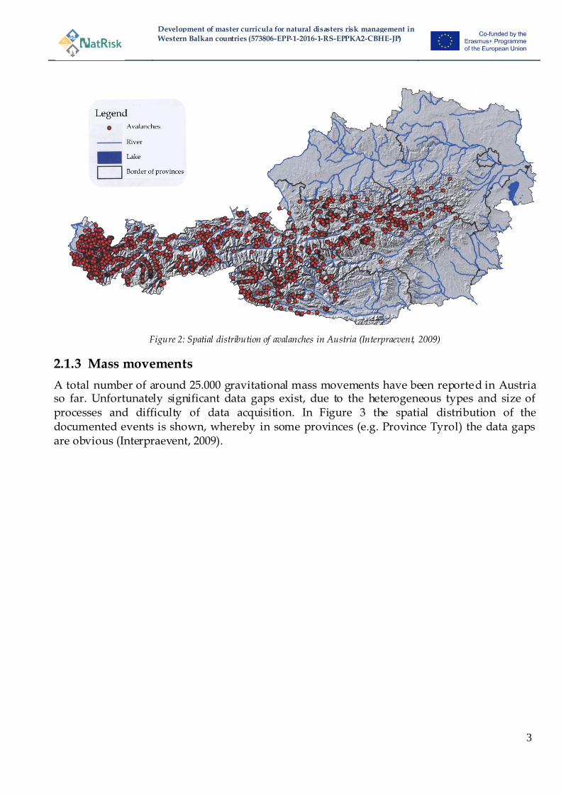
Figure 2: Spatial distribution of avalanches in Austria (Interpraevent, 2009)
2.1.3 Mass movements
A total number of around 25.000 gravitational mass movements have been reported in Austria so far. Unfortunately significant data gaps exist, due to the heterogeneous types and size of processes and difficulty of data acquisition. In Figure 3 the spatial distribution of the documented events is shown, whereby in some provinces (e.g. Province Tyrol) the data gaps are obvious (Interpraevent, 2009).
Development of master curricula for natural disasters risk management in
Western Balkan countries (573806-EPP-1-2016-1-RS-EPPKA2-CBHE-JP)
4
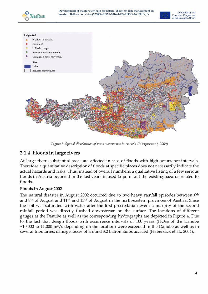
Figure 3: Spatial distribution of mass movements in Austria (Interpraevent, 2009)
2.1.4 Floods in large rivers
At large rivers substantial areas are affected in case of floods with high occurrence intervals. Therefore a quantitative description of floods at specific places does not necessarily indicate the actual hazards and risks. Thus, instead of overall numbers, a qualitative listing of a few serious floods in Austria occurred in the last years is used to point out the existing hazards related to floods.
Floods in August 2002
The natural disaster in August 2002 occurred due to two heavy rainfall episodes between 6th and 8th of August and 11th and 13th of August in the north-eastern provinces of Austria. Since the soil was saturated with water after the first precipitation event a majority of the second rainfall period was directly flushed downstream on the surface. The locations of different gauges at the Danube as well as the corresponding hydrographs are depicted in Figure 4. Due to the fact that design floods with occurrence intervals of 100 years (HQ100 of the Danube ~10.000 to 11.000 m³/s depending on the location) were exceeded in the Danube as well as in several tributaries, damage losses of around 3.2 billion Euros accrued (Habersack et al., 2004).
Development of master curricula for natural disasters risk management in
Western Balkan countries (573806-EPP-1-2016-1-RS-EPPKA2-CBHE-JP)
5
Figure 4: Overview of the gauges (Wallsee (W), Ybbs (Y), Melk (M), Kienstock (K), Altenwörth (A), Greifenstein (G), Freudenau (F)) and corresponding hydrograph of the gauges during the floods in August 2002 (Habersack et al., 2004)
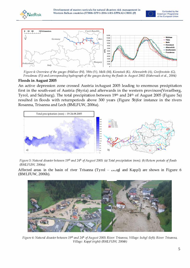
Floods in August 2005
An active depression zone crossed Austria inAugust 2005 leading to enormous precipitation first in the south-east of Austria (Styria) and afterwards in the western provinces(Vorarlberg, Tyrol, and Salzburg). The total precipitation between 19th and 24th of August 2005 (Figure 5a) resulted in floods with returnperiods above 300 years (Figure 5b)for instance in the rivers Rosanna, Trisanna and Lech (BMLFUW, 2006a).
Figure 5: Natural disaster between 19th and 24th of August 2005: (a) Total precipitation (mm); (b) Return periods of floods
(BMLFUW, 2006a)
Affected areas in the basin of river Trisanna (Tyrol – Ischgl and Kappl) are shown in Figure 6 (BMLFUW, 2006b).
Figure 6: Natural disaster between 19th and 24th of August 2005: River: Trisanna, Village: Ischgl (left); River: Trisanna, Village: Kappl (right) (BMLFUW, 2006b)
Niederschlagssummen vom 19. bis 24. August 2005
0
20
40
60
80
100
120
140
160
180
200
220
240
260
280
Total precipitation (mm) – 19-24.08.2005
Hauptstädte.shp
Gewässer
< HQ1
HQ 1 - 5
>HQ 5 - HQ10
>HQ10 - HQ30
>HQ30 - HQ50
>HQ50 - HQ100
>HQ100 - HQ300
> HQ300 - extrem
a) b)

Development of master curricula for natural disasters risk management in
Western Balkan countries (573806-EPP-1-2016-1-RS-EPPKA2-CBHE-JP)
6
Floods in June 2013
In June 2013 enormous precipitation led to floods in large areas of Austria. According to estimates around 866 million Euros in losses were caused by these natural disasters. The occurrence intervals in different river basins are depicted in Figure 7. River basins in the north of the Alps were strongly affected and the water masses of these rivers discharged into the Danube resulting in a more than 100-years flood in the largest river of Austria(BMLFUW, 2015).
Figure 7: Overview of the recurrence intervals during the floods in June 2013 in Austria (BMLFUW, 2015)
The following photo documentation (Figure 8) shows the effects of this serious flood in rural areas and is referenced in Figure 7 at position 1.
Figure 8: Areal image of municipality Goldwörth during the floods in June 2013 (BMLFUW, 2015)
Development of master curricula for natural disasters risk management in
Western Balkan countries (573806-EPP-1-2016-1-RS-EPPKA2-CBHE-JP)
7
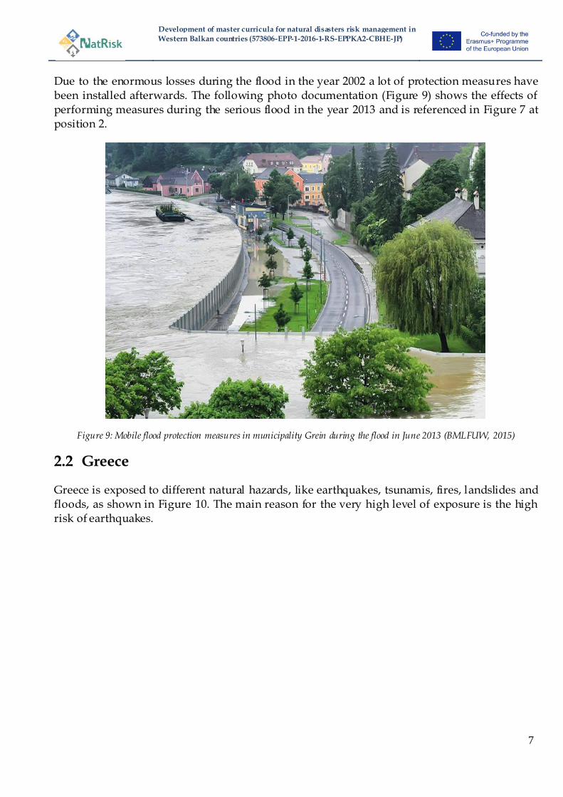
Due to the enormous losses during the flood in the year 2002 a lot of protection measures have been installed afterwards. The following photo documentation (Figure 9) shows the effects of performing measures during the serious flood in the year 2013 and is referenced in Figure 7 at position 2.
Figure 9: Mobile flood protection measures in municipality Grein during the flood in June 2013 (BMLFUW, 2015)
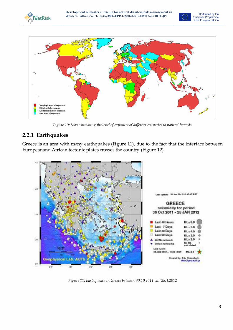
2.2 Greece
Greece is exposed to different natural hazards, like earthquakes, tsunamis, fires, landslides and floods, as shown in Figure 10. The main reason for the very high level of exposure is the high risk of earthquakes.
Development of master curricula for natural disasters risk management in
Western Balkan countries (573806-EPP-1-2016-1-RS-EPPKA2-CBHE-JP)
8
Figure 10: Map estimating the level of exposure of different countries to natural hazards
2.2.1 Earthquakes
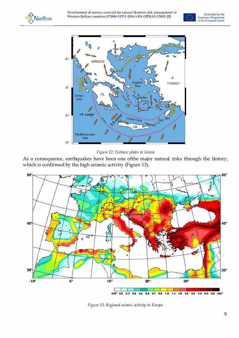
Greece is an area with many earthquakes (Figure 11), due to the fact that the interface between Europeanand African tectonic plates crosses the country (Figure 12).
Figure 11: Earthquakes in Greece between 30.10.2011 and 28.1.2012
Development of master curricula for natural disasters risk management in
Western Balkan countries (573806-EPP-1-2016-1-RS-EPPKA2-CBHE-JP)
9
Figure 12: Tectonic plates in Greece
As a consequence, earthquakes have been one ofthe major natural risks through the history , which is confirmed by the high seismic activity (Figure 13).
Figure 13: Regional seismic activity in Europe

Development of master curricula for natural disasters risk management in
Western Balkan countries (573806-EPP-1-2016-1-RS-EPPKA2-CBHE-JP)
10
2.2.2 Tsunamis
Evidence that some tsunami risks appeared in the past does exist. The pre-hellenic, minoan civilization in Crete may have been destroyed from a tsunami created in the Aegais and stroke the island after an earthquake.
2.2.3 Fire
Ancient city-centers with narrow roads and many wooden houses traditionally suffered from big fires. A considerable part of old city in Thessaloniki has been destroyed due to a fire. Modern regulations and use of inflammable materials usually reduce this risk. On the other side, new fire thread appears, like the installation of photovoltaic installations on the top of residential buildings. Another modern risk which is expected to dominate fire engineering in Greece in the coming decades, is the fire and disaster management in on shore and off shore installations. On shore facilities do exist, off shore facilities are being expanded.
2.2.4 Landslides and floods
Extreme weather phenomena, like heavy rainfalls, lead to natural disasters including landslides and floods in Greece.
2.3 Hungary
Hungary has always been endangered by natural disasters. As the country has a downhill character, the most frequent and typical crisis type is flood. Flood protection has thus historically been an important task for its inhabitants. The two largest rivers are the Danube and Tisza. Over 50 percent of the overall territory of Hungary, including two thirds of the arable land is endangered by flood hazards. On the Danube with a 10 -12 year interval and on the Tisza every 5-6 years, there are larger floods (Janik, 2006 pp.71-76, Vari, 2002).
Development of master curricula for natural disasters risk management in
Western Balkan countries (573806-EPP-1-2016-1-RS-EPPKA2-CBHE-JP)
11
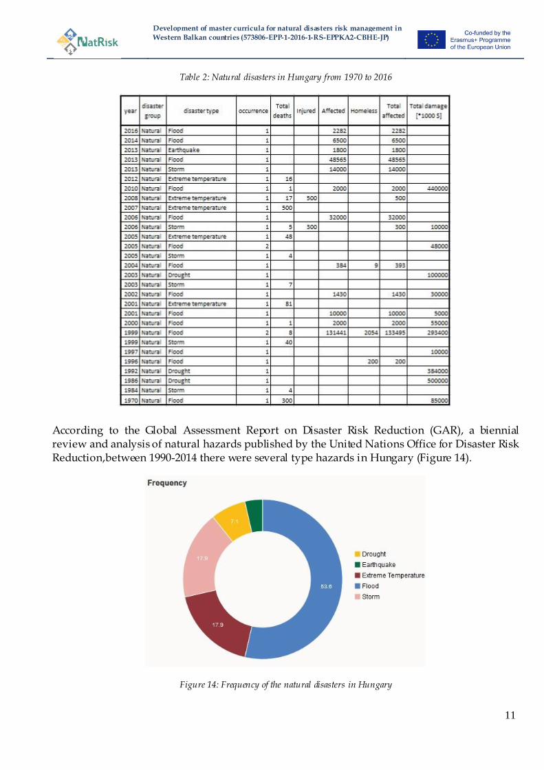
Table 2: Natural disasters in Hungary from 1970 to 2016
According to the Global Assessment Report on Disaster Risk Reduction (GAR), a biennial review and analysis of natural hazards published by the United Nations Office for Disaster Risk Reduction,between 1990-2014 there were several type hazards in Hungary (Figure 14).
Figure 14: Frequency of the natural disasters in Hungary
Development of master curricula for natural disasters risk management in
Western Balkan countries (573806-EPP-1-2016-1-RS-EPPKA2-CBHE-JP)
12
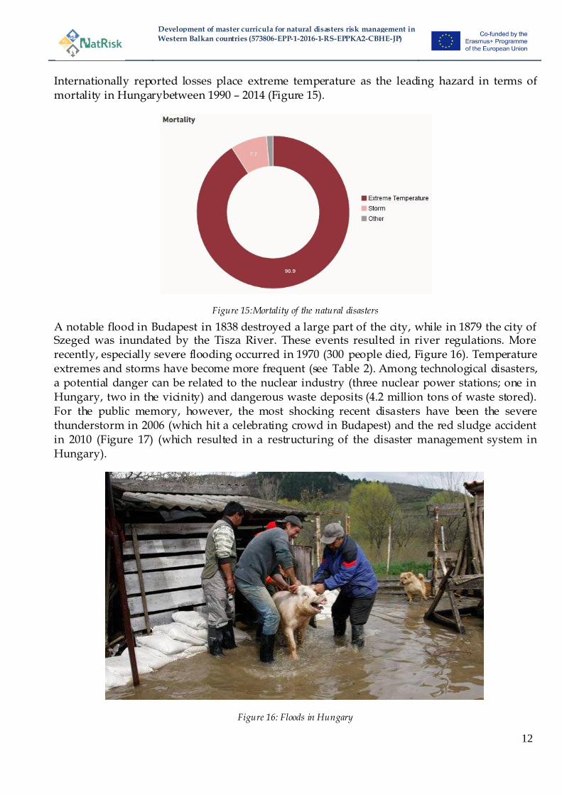
Internationally reported losses place extreme temperature as the leading hazard in terms of mortality in Hungarybetween 1990 – 2014 (Figure 15).
Figure 15:Mortality of the natural disasters
A notable flood in Budapest in 1838 destroyed a large part of the city, while in 1879 the city of Szeged was inundated by the Tisza River. These events resulted in river regulations. More recently, especially severe flooding occurred in 1970 (300 people died, Figure 16). Temperature extremes and storms have become more frequent (see Table 2). Among technological disasters, a potential danger can be related to the nuclear industry (three nuclear power stations; one in Hungary, two in the vicinity) and dangerous waste deposits (4.2 million tons of waste stored). For the public memory, however, the most shocking recent disasters have been the severe thunderstorm in 2006 (which hit a celebrating crowd in Budapest) and the red sludge accident in 2010 (Figure 17) (which resulted in a restructuring of the disaster management system in Hungary).
Figure 16: Floods in Hungary

Development of master curricula for natural disasters risk management in
Western Balkan countries (573806-EPP-1-2016-1-RS-EPPKA2-CBHE-JP)
13
Figure 17: Red sludge accident in Hungary, 2010
In Hungary, disaster was officially defined first in 1999 (Disaster Management Law 1999) and further clarified in 2011 (Disaster Management Law CXXVIII /2011). Disaster is an event that endangers people and people‘s goods or infrastructure to such an extent that it is not possible to cope within the normal responsibility and cooperative framework of institutions. A description of conditions related to this special legal order is given in the New Fundamental Law (articles 48-53). Civil protection activity started in 1937 (protecting civilian life and property against air offensives during the war). In 1950 the civil protection system was reorganized with the priority task still ―protection against airoffensives‖,thoughofteninvolvedduringothertypesofcrisis response (under the Ministry of Defense). From the end of the 90‘s the civil protection law (XXXVII /1996) enumerated the main tasks of civil protection (as it is stated in the Geneva agreement). Following the disaster management law in 1999, the Civil Protection Directorate became a part of the disaster management system (Hoffmann and Nemeth 2010). The disaster management and civil protection systems are in general separated from the army. However, in case of natural disaster the army can be involved (Defence Law 2004, later 2011 article 36/2). Army involvement can be initiated by the government or army authorities (the leader of the armed forces or the minister of internal affairs). There are distinct institutions assigned for specific hazards. However, recent changes have led towards an all hazard approach. From 2012, all civil protection and most firefighting tasks were moved under the disaster management authorities. Also, flood protection issues of water management were moved under the Ministry of Interior (previously under the Ministry of Environment). Based on the new disaster management law, the disaster management authorities (National Directorate General for Disaster Management, NDGDM) located within the Ministry of Interior and regional directorates have a supervising position over the cooperating institutions.

Development of master curricula for natural disasters risk management in
Western Balkan countries (573806-EPP-1-2016-1-RS-EPPKA2-CBHE-JP)
14
2.4 Italy
The whole territory is exposed at a high seismic risk, as witness by the continuous emergencies occurring in different region of Italy. Volcanic risks are concentrated in south Italy, mostly in Sicily (including Aeolian Islands) and Campania. Because approximately two thirds of the Italian national territory account for Alpines and Apennines regions, the natural hazards related to mountains are important, but they have a different develop depending from the sector. A distinction is drawn among hazards of northern rivers (floods), of southern streams and slopes (e.g.: mud and debris flows) and of avalanches occurring both in Alps or Apennines. Additionally, due to geological conditions, mass movements like landslides or rockfalls are repeatedly occurring in several areas in Italy. Italy with its 8,300 km of coastlines is the second longest one in Europe and 25% of these ones are under erosion with a land lost in the la 25 years of about 15- 16 Km2.
2.4.1 Earthquakes
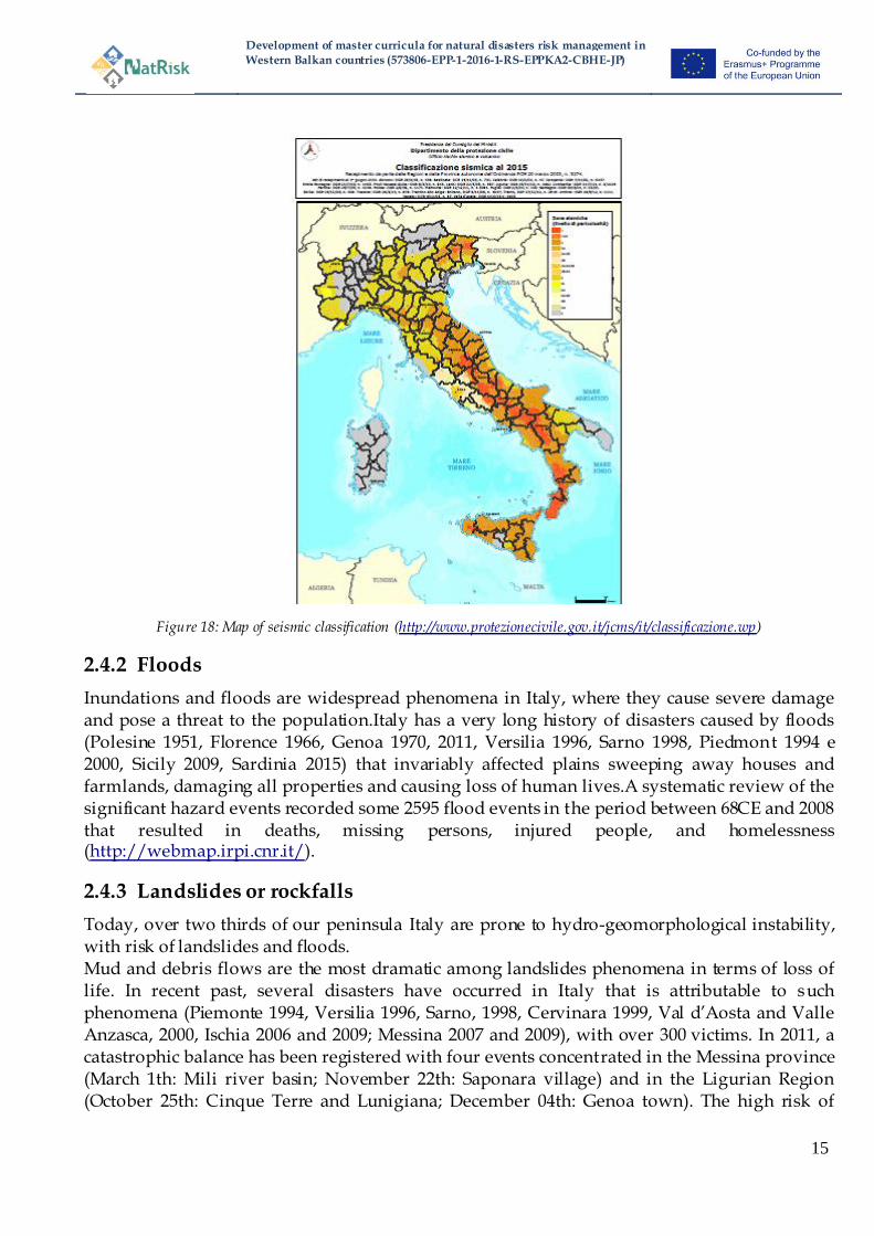
In Italy, numerous studies and documents regarding the seismicity have been produced. The first considerations, often imaginary, about the origin of earthquakes and the seismic characteristics of Italy can be traced right back to works in the fifteenth century. But it was only in the nineteenth century, with the development of seismological sciences, that research into the causes and geographic distribution of earthquakes started to be published. Wider use of seismic instruments from the end of the nineteenth century and monitoring networks in the twentieth century finally provided input for studies into seismic characterisation in Italy. One of the newest maps of seismic classification was drawn in the year 2015 and is shown in Figure 18.
Development of master curricula for natural disasters risk management in
Western Balkan countries (573806-EPP-1-2016-1-RS-EPPKA2-CBHE-JP)
15
Figure 18: Map of seismic classification (http://www.protezionecivile.gov.it/jcms/it/classificazione.wp)
2.4.2 Floods
Inundations and floods are widespread phenomena in Italy, where they cause severe damage and pose a threat to the population.Italy has a very long history of disasters caused by floods (Polesine 1951, Florence 1966, Genoa 1970, 2011, Versilia 1996, Sarno 1998, Piedmont 1994 e 2000, Sicily 2009, Sardinia 2015) that invariably affected plains sweeping away houses and farmlands, damaging all properties and causing loss of human lives.A systematic review of the significant hazard events recorded some 2595 flood events in the period between 68CE and 2008 that resulted in deaths, missing persons, injured people, and homelessness (http://webmap.irpi.cnr.it/).
2.4.3 Landslides or rockfalls
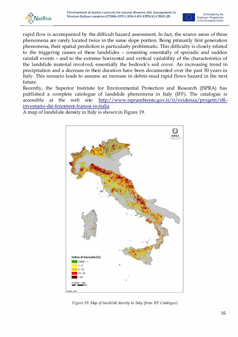
Today, over two thirds of our peninsula Italy are prone to hydro-geomorphological instability, with risk of landslides and floods. Mud and debris flows are the most dramatic among landslides phenomena in terms of loss of life. In recent past, several disasters have occurred in Italy that is attributable to such phenomena (Piemonte 1994, Versilia 1996, Sarno, 1998, Cervinara 1999, Val d‘Aosta and Valle Anzasca, 2000, Ischia 2006 and 2009; Messina 2007 and 2009), with over 300 victims. In 2011, a catastrophic balance has been registered with four events concentrated in the Messina province (March 1th: Mili river basin; November 22th: Saponara village) and in the Ligurian Region (October 25th: Cinque Terre and Lunigiana; December 04th: Genoa town). The high risk of
Development of master curricula for natural disasters risk management in
Western Balkan countries (573806-EPP-1-2016-1-RS-EPPKA2-CBHE-JP)
16
rapid flow is accompanied by the difficult hazard assessment. In fact, the source areas of these phenomena are rarely located twice in the same slope portion. Being primarily first generation phenomena, their spatial prediction is particularly problematic. This difficulty is closely related to the triggering causes of these landslides – consisting essentially of sporadic and sudden rainfall events – and to the extreme horizontal and vertical variability of the characteristics of the landslide material involved, essentially the bedrock‘s soil cover. An increasing trend in precipitation and a decrease in their duration have been documented over the past 50 years in Italy. This scenario leads to assume an increase in debris-mud rapid flows hazard in the next future. Recently, the Superior Institute for Environmental Protection and Research (ISPRA) has published a complete catologue of landslide phenomena in Italy (IFF). The catalogue is accessible at the web site: http://www.isprambiente.gov.it/it/evidenza/progetti/iffi -inventario-dei-fenomeni-franosi-in-italia A map of landslide density in Italy is shown in Figure 19.
Figure 19: Map of landslide density in Italy (from IFF Catalogue)

Development of master curricula for natural disasters risk management in
Western Balkan countries (573806-EPP-1-2016-1-RS-EPPKA2-CBHE-JP)
17
2.4.4 Coastal erosion
According to the Atlas of the Italian Beaches (Fierro and Ivaldi, 2001), 27 % of the Italian beaches which constitute 61 % of the total Italian coastline are retreating, 70 % in equilibrium, and only 3 % prograding. A map of coastal susceptibility in Italy is shown in Figure 20. The causes can be natural but mostly are anthropogenic ones.
Figure 20: Map of coastal erosion susceptibility in Italy
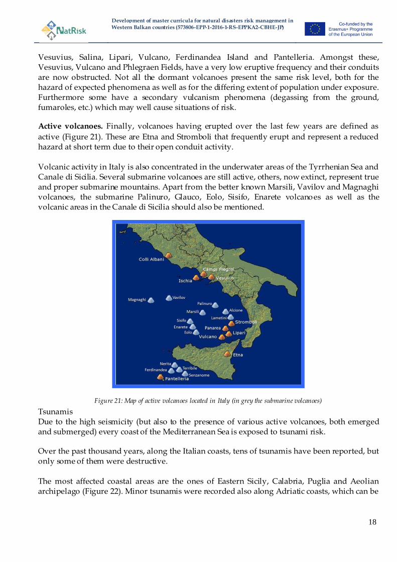
2.4.5 Volcanic eruption
Amongst the criteria adopted by the international scientific community to classify Italian volcanoes, we have the Activity Status dividing them into extinct, dormant and active. Extinct volcanoes.Volcanoes, which last erupted over 10,000 years ago, is defined as extinct.
These include the Amiata, Vulsini, Cimini, Vico, Sabatini, Pontine Islands, Roccamonfina and Vulture volcanoes. Dormant volcanoes.Whereas dormant volcanoes have erupted during the last 10,000 years but
are currently in a period of dormancy. According to a more exacting definition, volcanoes with a current period of dormancy shorter than the longest period of dormancy registered previously are considered dormant. Here we have: ColliAlbani, Phlegraen Fields, Ischia,
Development of master curricula for natural disasters risk management in
Western Balkan countries (573806-EPP-1-2016-1-RS-EPPKA2-CBHE-JP)
18
Vesuvius, Salina, Lipari, Vulcano, Ferdinandea Island and Pantelleria. Amongst these, Vesuvius, Vulcano and Phlegraen Fields, have a very low eruptive frequency and their conduits are now obstructed. Not all the dormant volcanoes present the same risk level, both for the hazard of expected phenomena as well as for the differing extent of population under exposure. Furthermore some have a secondary vulcanism phenomena (degassing from the ground, fumaroles, etc.) which may well cause situations of risk. Active volcanoes. Finally, volcanoes having erupted over the last few years are defined as
active (Figure 21). These are Etna and Stromboli that frequently erupt and represent a reduced hazard at short term due to their open conduit activity. Volcanic activity in Italy is also concentrated in the underwater areas of the Tyrrhenian Sea and Canale di Sicilia. Several submarine volcanoes are still active, others, now extinct, represent true and proper submarine mountains. Apart from the better known Marsili, Vavilov and Magnaghi volcanoes, the submarine Palinuro, Glauco, Eolo, Sisifo, Enarete volcanoes as well as the volcanic areas in the Canale di Sicilia should also be mentioned.
Figure 21: Map of active volcanoes located in Italy (in grey the submarine volcanoes)
Tsunamis Due to the high seismicity (but also to the presence of various active volcanoes, both emerged and submerged) every coast of the Mediterranean Sea is exposed to tsunami risk. Over the past thousand years, along the Italian coasts, tens of tsunamis have been reported, but only some of them were destructive. The most affected coastal areas are the ones of Eastern Sicily, Calabria, Puglia and Aeolian archipelago (Figure 22). Minor tsunamis were recorded also along Adriatic coasts, which can be

Development of master curricula for natural disasters risk management in
Western Balkan countries (573806-EPP-1-2016-1-RS-EPPKA2-CBHE-JP)
19
reached by tsunamis generated far away (e.g. following a strong earthquake in the sea of Greece).
Figure 22:Tsunamis in the central Mediterranean region
2.5 United Kingdom
The United Kingdom (UK) is a decentralised unitary state which is composed of England and three other countries (Scotland, Northern Ireland and Wales) which have differing degrees of devolved responsibilities. Some aspects of managing natural risks are therefore managed separately by the fours nations and as such the UK has a very complex mix of agencies, laws and policies. For example, the Floods Directive was transposed into legislation separately for England and Wales, Scotland and Northern Ireland (e.g. see Flood Risk Regulations 2009 (E and W); Flood Risk Management (Scotland) Act 2009; The Water Environment (Floods Directive) Regulations (Northern Ireland) 2009). Due to these differences, the sections in this report will primarily focus on the circumstances related to England, however where the discussion is focussing more generally on the UK, this will be indicated. Two key approaches are utilised herein to identify and select the key natural risks affecting the United Kingdom; governmental-led risk assessments which aim to identity and plan for current and future risks and also examples of past events. The UK government have produced a National Risk Register of Civil Emergencies (Cabinet Office, 2015) which assesses the risks in the
UK over the next five years with the aim of providing information to assist the public and other authorities with managing them. One risk category that is defined is that of ‗natural risks‘, however this has a very broad definition and importantly considers the impact of any natural event on the country, not only those which originate from within the UK. Principally, this ‗natural risk‘ category includes Human Diseases (e.g. Pandemic Flu), Flooding (divided here into coastal and inland, Poor Air Quality events, Volcanic hazards (e.g. examining the impacts of overseas eruptions), severe space weather (e.g. solar flares, radiation storms), Severe weather (including storms and gales, low temperatures and heavy snow, heatwaves, drought), Severe

Development of master curricula for natural disasters risk management in
Western Balkan countries (573806-EPP-1-2016-1-RS-EPPKA2-CBHE-JP)
20
Wildfires and Animal diseases (e.g. foot and mouth disease, rabies etc.). This risk assessment then identifies those risks which it considers to be most significant on two risk matrices which consider the scale of the impact and the probability of occurrence. The matrix related to ‗other risks‘ (i.e. non-terrorism/malicious attack) is presented in Figure 23. This figure highlights the key concern of coastal flooding, with inland flooding, heatwaves and low temperatures/heavy snow having a medium risk concern.
Figure 23: Risk matrix of „other risks‟ to the UK (Cabinet Office, 2015; 13).
Another body of work that has contributed to the UK debate in this area is the Climate Change Risk Assessment 2017 which aims to provide evidence for and ―assess the urgency of further action to tackle current and future risks, and realise opportunities, arising for the UK from climate change.‖ (CCC, 2017). This report also emphasises that the greatest increase in risk magnitude are in the areas of flooding and coastal risks and the risks to health and well -being and productivity from high temperatures (CCC, 2017). Data from the EM-DAT database (CRED, 2009) can provide some indication of the scale of events which have affected the UK in past years. Although the dataset has some limitations if the absolute values are presented (i.e. there are questions about how deaths or damages are attributed to specific events) and the resolution of the data, it is very useful in providing some indication of the relative importance of different type of natural risks in the UK. (This database

Development of master curricula for natural disasters risk management in
Western Balkan countries (573806-EPP-1-2016-1-RS-EPPKA2-CBHE-JP)
21
enters a record in the database if any of the following criteria are are present: 10 or more people killed, 100 or more people affected/injured/homeless, significant disaster, e.g. ‗worst disaster in the decade‘, significant damage, e.g. ‗most costly disaster‘.) Table 3 highlights the ten most severe natural events experienced in the last 30 years (i.e. 1986-2016). Events in these cases have been ranked based on the different types of impact that have been experienced: numbers of fatalities, numbers of people affected and an estimate of the economic damages.
Table 3: Top ten natural disasters in the UK ranked by fatalities, total number of people affected and total damages sustained
Total Fatalities Ranking Disaster No Type Date Totals deaths
1 2013-0549 Extreme temperature Jul-13 760 2 2003-0391 Extreme temperature Jul-03 301
3 1991-0004 Storm 05/01/1991 48
4 1990-0717 Storm 25/01/1990 47 5 1987-0191 Storm 15/10/1987 20
6 1990-0722 Storm 25/02/1990 18
7 1990-0723 Storm 28/02/1990 18
8 1998-0007 Storm 01/01/1998 15 9 1997-0004 Extreme temperature 04/12/1997 14
10 2007-0019 Storm 18/01/2007 13
Total People Affected Ranking Disaster No Type Date Total affected
1 2007-0278 Flood 20/07/2007 340000
2 1998-0419 Storm 24/12/1998 250000
3 2015-0561 Flood 26/12/2015 48000 4 2007-0247 Flood 25/06/2007 30000
5 2000-0714 Storm 28/10/2000 19504
6 2014-0067 Storm 14/02/2014 18000 7 2015-0525 Storm 04/12/2015 15600
8 1996-0252 Storm 27/10/1996 12000
9 2007-0692 Earthquake 28/04/2007 4501 10 2013-0517 Storm 06/12/2013 4200
Total Damages Ranking Disaster No Type Date Total damage ('000 US$)
1 2000-0662 Flood 11/10/2000 5900000
2 2007-0247 Flood 25/06/2007 4000000 3 2007-0278 Flood 20/07/2007 4000000
4 1990-0717 Storm 25/01/1990 3400000
5 2012-0552 Flood 21/11/2012 1630000 6 1987-0191 Storm 15/10/1987 1565000
7 2000-0714 Storm 28/10/2000 1500000
8 2013-0572 Flood 27/12/2013 1500000 9 2015-0561 Flood 26/12/2015 1200000
10 2007-0019 Storm 18/01/2007 1200000
When considering fatalities three of the most severe events relate to deaths from extreme temperature, whilst the remaining seven relate to storm events. However, what also is important is a consideration of the difference in magnitude of the deaths experienced with 760 fatalities being attributed to the effects of extreme temperature in July 2013 and 301 in July 2003, whilst the fatalities from storm events only reaching a maximum of 48. By comparison, when
Development of master curricula for natural disasters risk management in
Western Balkan countries (573806-EPP-1-2016-1-RS-EPPKA2-CBHE-JP)
22
considering the other ways of ranking the most severe impacts (e.g. total numbers affected and economic damages) principally floods and storms dominate. Although the UK is potentially subject to a wide range of natural risks if a broad definition is considered, the following sections will concentrate on a more narrow focus of natural risks as understood in the NatRisk project (i.e. concentrating principally on hydro -meteorological events).Furthermore, although there may be natural risks which will have locally important impacts (e.g. landslides), the following sections will also focus on those risks which had higher impacts in recent years and which are identified as being more nationally significant.
2.5.1 Flooding
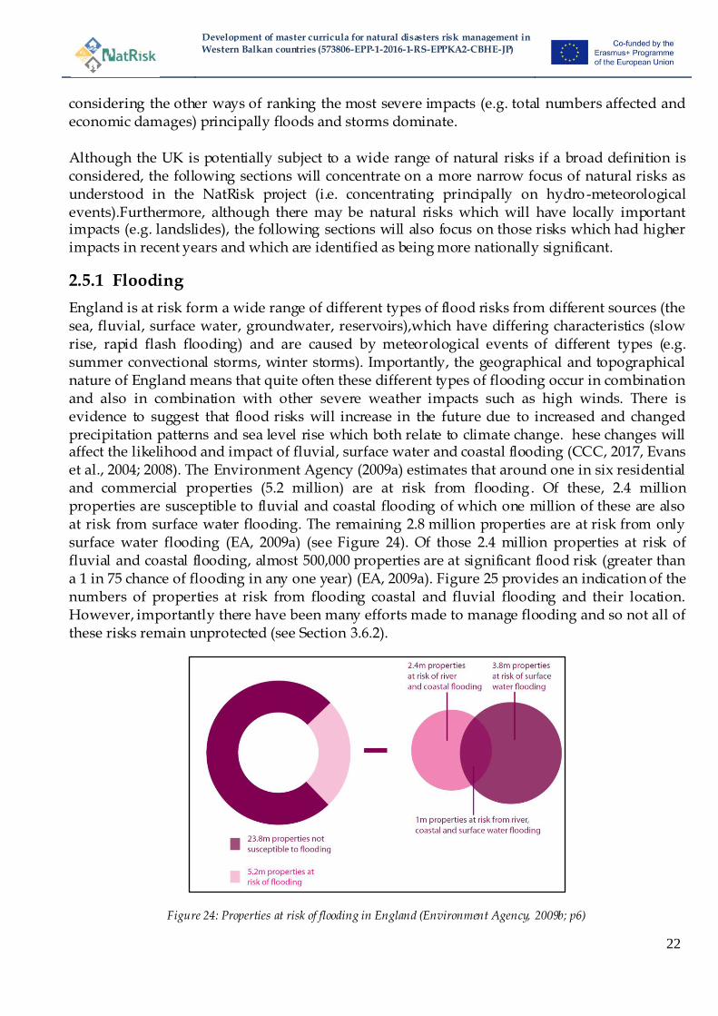
England is at risk form a wide range of different types of flood risks from different sources (the sea, fluvial, surface water, groundwater, reservoirs),which have differing characteristics (slow rise, rapid flash flooding) and are caused by meteorological events of different types (e.g. summer convectional storms, winter storms). Importantly, the geographical and topographical nature of England means that quite often these different types of flooding occur in combination and also in combination with other severe weather impacts such as high winds. There is evidence to suggest that flood risks will increase in the future due to increased and changed precipitation patterns and sea level rise which both relate to climate change. hese changes will affect the likelihood and impact of fluvial, surface water and coastal flooding (CCC, 2017, Evans et al., 2004; 2008). The Environment Agency (2009a) estimates that around one in six residential and commercial properties (5.2 million) are at risk from flooding. Of these, 2.4 million properties are susceptible to fluvial and coastal flooding of which one million of these are also at risk from surface water flooding. The remaining 2.8 million properties are at risk from only surface water flooding (EA, 2009a) (see Figure 24). Of those 2.4 million properties at risk of fluvial and coastal flooding, almost 500,000 properties are at significant flood risk (greater than a 1 in 75 chance of flooding in any one year) (EA, 2009a). Figure 25 provides an indication of the numbers of properties at risk from flooding coastal and fluvial flooding and their location. However, importantly there have been many efforts made to manage flooding and so not all of these risks remain unprotected (see Section 3.6.2).
Figure 24: Properties at risk of flooding in England (Environment Agency, 2009b; p6)
Development of master curricula for natural disasters risk management in
Western Balkan countries (573806-EPP-1-2016-1-RS-EPPKA2-CBHE-JP)
23
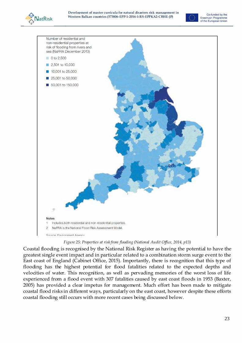
Figure 25: Properties at risk from flooding (National Audit Office, 2014, p13)
Coastal flooding is recognised by the National Risk Register as having the potential to have the greatest single event impact and in particular related to a combination storm surge event to the East coast of England (Cabinet Office, 2015). Importantly, there is recognition that this type of flooding has the highest potential for flood fatalities related to the expected depths and velocities of water. This recognition, as well as pervading memories of the worst loss of life experienced from a flood event with 307 fatalities caused by east coast floods in 1953 (Baxter, 2005) has provided a clear impetus for management. Much effort has been made to mitigate coastal flood risks in different ways, particularly on the east coast, however despite these efforts coastal flooding still occurs with more recent cases being discussed below.

Development of master curricula for natural disasters risk management in
Western Balkan countries (573806-EPP-1-2016-1-RS-EPPKA2-CBHE-JP)
24
Various types of fluvial flood risk are experienced including rapid onset flash flooding within steeper catchments as well as slow rise flooding from smaller or larger rivers. The Cabinet Office (2015) suggests that the frequency of inland flooding is increasing with significant floods occurring in 2007, 2009, 2010, 2012, 2013 and 2014. Although efforts have been made to manage flooding (see Section 3.6) not all of these measures are oriented towards preventing flooding or flood protection and therefore it is expected that some residual risk will remain and will need to be managed in different ways. Recent flooding, and initiatives to assess risk following these events, has highlighted the significance of surface water flooding (see Figure 26) and increasing addition has been paid to managing these risks. Surface water flooding includes inundation from run-off, but is also related to inadequate drainage, and this type of flooding has been present in all of the recent events discussed below.
Figure 26: Number of properties located in areas at significant risk of flooding by Local Authority boundary (Environment Agency, 2009a; 27).
Development of master curricula for natural disasters risk management in
Western Balkan countries (573806-EPP-1-2016-1-RS-EPPKA2-CBHE-JP)
25
2007 Summer floods
The floods experienced in Summer 2007 is one of the most widespread and nationally significant flood events of recent years. England and Wales experienced extremely wet weatherwith a cumulative rainfall total of 395.1mm (for both England and Wales) for May to July 2007 which is more than twice theaverage amount of rainfall (Pitt, 2008). Fluvial and surface water flooding were the principal sources of flooding with the numbers of properties flooded from surface water considered to behigher. It is important to recognise that the flooding did not just occur on one occasion andextended over a considerable period of time, but that there were two key distinct flood events. The north of England was affected by heavy thunderstorm rainfall in mid-June and led to flooding across many counties (Yorkshire, Humberside, Lincolnshire, Derbyshire and Worcestershire) with the cities of Hull and Sheffield being particularly severely affected (Chatterton et al., 2010). Further flooding was experienced in late July caused by heavy rainfall from a depression slowly moving from south-east England northwards falling on already saturated ground (Pitt, 2008). There were thirteen fatalities in the floods and a total around 48,000 homes and 7,300 business properties were flooded. Additionally, the event caused widespread disruption to transport and utility networks (Pitt, 2008). Indeed, in Gloucestershire, c. 140,000 properties lost access to a clean water supply for up to 17 days (Chatterton et al., 2010). The total economic costs of the flooding were estimated to be around £3.2 billion at 2007 prices (Chatterton et al., 2010). The widespread scale and types of impacts (i.e. significant amount of disruption to critical infrastructure) led the government to commission an independent review into the floods conducted by Sir Michael Pitt (Pitt, 2008) which made 92 recommendations for changes to all areas of flood risk management (e.g. see Defra, 2008; 2009; 2012). These recommendations, in combination with other initiatives and requirements (such as the Floods Directive) have seen recent clarifications and changes to English flood risk management (see sections 3.6 and 4.5).
Winter 2013/14 storms and floods
In contrast to the summer 2007 event, the 2013/14 floods occurred during winter and originated from a period of stormy weather which affected all of the UK during the four months from October 2013 to February 2014. Various areas of the country experienced flooding from a series of different weather events. Coastal flooding occurred in a variety of different areas. The east coast of England suffered from the highest tidal surge in 60 years in early December 2013 which caused an evacuation of thousands of residents and to the inundation of 2,800 houses (Cabinet Office, 2015; Chatterton et al., 2016). Storms around Christmas in December 2013 caused inland flooding across southern England, travel disruption to roads, rail and Heathrow airport and an extensive loss of power. Both Wales and the south-west of England (Devon and Cornwall) were affected by storms in early January as well as February 2014. Many roads to this region were cut (the A631 being shut for 12 weeks) (Chatterton et al., 2016) and the nature of the infrastructure in this part of England means this results in severe disruption and lengthy detours. Furthermore, a 100 metre stretch of railway near Dawlish in Cornwall was destroyed, completely shutting the line for a number of weeks and leading to thousands of train cancellations (Chatterton et al., 2016). This period of flooding was also unusual due to theduration of the impacts being experienced. The Somerset Levels, in the south of England, suffered significant flooding throughout this period, with areas and a small number of properties being inundated for many weeks during the floods (DCLG, 2014).

Development of master curricula for natural disasters risk management in
Western Balkan countries (573806-EPP-1-2016-1-RS-EPPKA2-CBHE-JP)
26
In total it was estimated that 8,342 homes and 4,459 businesses were directly flooded, with a further 7,000 properties suffering from a loss of water or other essential services (DCLG, 2014). The total economic damages of the event were in the region of £1,300 million in England and Wales (Chatterton et al., 2016). Not all of the disruption, however, was caused directly by flooding, but also by high winds associated with the severe weather with roads being affected by fallen trees and electricity being affected by fallen power lines. However, despite the losses and disruption experienced, the event also served to highlight the effectiveness of many of the existing flood management responses. It was estimated by the Environment Agency that flood defences prevented the inundation of around 1.4 million properties (DCLG, 2014). Winter 2015/16 storms and floods
Similar to the events of winter 2013/14, the floods in winter 2015/16 are characterised by a series of severe weather events some of which were linked to named storm events (e.g. Storms Desmond, Eva and Frank; Priestley, 2016) and rainfall that was considered to be the highest since records began (Marsh et al., 2016). Unlike the floods in 2013/14 which affected many different parts of the country in winter 2015/16 the floods were primarily concentrated in the north and west of England where the rainfall was highest, the catchments affected were steep and had relatively thin soil cover so that insufficient rainfall was absorbed (Marsh et al., 2016). Areas significantly affected by flooding included Cumbria, and in particular the city of Carlisle, as well as Manchester, Lancashire and Yorkshire. Investigations into the 2015/16 floods remain ongoing and the Environment Agency official report about the total costs of the floods is yet to be published. However, estimates suggest that there are insured flood losses of £1.3 billion (ABI, 2016) although the total costs of Storm Desmond on all of the UK are estimated to be around £5 billion (EFRA, 2016). Similarly, there are multiple estimates of the numbers of properties impacted and are complicated by the fact that some properties flooded multiple times. The Association of British Insurers (2016) estimated a total of 22,000 flood claims of which c. 5600 were for businesses and 6700 were motor claims. However, the government also estimated that flood defences helped to protect over 11,000 properties and provided time to evacuate both people and property (UK Government, 2016). Part of the significance of the winter 2015/16 floods on flood risk management was that it affected areas such as Cumbria which had previously been flooded (notably in 2005 and 2009: Cowen and Mallinson, 2009; Cumbria Resilience, 2011) and had received considerable investment in flood defence infrastructure which many thought would prevent future flooding. Following assessment of the causes of flooding it was considered that the defences did not ‗fail‘ but significant amount of rainfall experienced caused flooding was above the design standard for the defences. It has also reignited the debate about whether natural flood management might be used in certain areas to reduce flooding (Environment Agency, 2016; HMGovernment, 2016). The floods also reinforced existing concerns about risks to infrastructure and led to a major review to consider these aspects (HM Government, 2016); whereby actions from the recommendations remain ongoing.
Development of master curricula for natural disasters risk management in
Western Balkan countries (573806-EPP-1-2016-1-RS-EPPKA2-CBHE-JP)
27
2.5.2 High temperatures and heatwaves
Public Health England (PHE) (2015a) have analysed the risk of the health impacts and an increased number of deaths associated with high temperatures and heatwaves in England and are responsible for setting out a plan for managing them. PHE (2015a; 3) report that in England in Summer 2006 ―a linear relationship between temperature and weekly mortality was observed…with an estimated 75 extra deaths per week for each degree of increased temperature.‖ Concern is growing that these extreme weather events may become more common and/or severe under climate change (CCRA, 2017) and thus a greater emphasis is being placed on preparing and managing these events (PHE 2015a; 2015b).
3 Analysis of established risk management strategies
3.1 EU
The European Union decided to set up joint strategies on how to deal with natural disasters. This approach is justified, due to the fact that natural disasters often occur in large areas ignoring national borders and affecting many different states. These joint strategies are documented in EU-directives, which should be further implemented in national laws of the member states. The main aspects within these directives are the implementation of uniform standards, mutual learning based on national experiences and a rapid information transfer in case of emergency.
3.1.1 EU Water Framework Directive
The EU Water Framework Directive (WFD) (EU Directive 2000/60/EG) came into force on 22ndof December 2000 and unified the legal framework for water policy within the EU. The guiding principle was to align the water policy towards a sustainable and environmental friendly usage. In detail, the following purposes have been defined for the protection of inland surface waters, transitional waters, coastal waters and groundwater:
a) prevents further deterioration and protects and enhances the status of aquatic ecosystems and, with regard to their water needs, terrestrial ecosystems and wetlands directly depending on the aquatic ecosystems;
b) promotes sustainable water use based on a long-term protection of available water resources;
c) aims at enhanced protection and improvement of the aquatic environment, inter alia, through specific measures for the progressive reduction of discharges, emissions and losses of priority substances and the cessation or phasing-out of discharges, emissions and losses of the priority hazardous substances;
d) ensures the progressive reduction of pollution of groundwater and prevents its further pollution, and
e) contributes to mitigating the effects of floods and droughts
In the main purposes of the WFD mitigating effects of floods and droughts have already been mentioned, which have been specified in the EU Floods Directive.

Development of master curricula for natural disasters risk management in
Western Balkan countries (573806-EPP-1-2016-1-RS-EPPKA2-CBHE-JP)
28
Additionally, some guiding principles have been defined in the WFD and are also valid in the EU Floods Directive.
Coordination of management activities within river basins
Consideration of definition within the WFD Consideration of defined river basin management plans
Consideration of public participation Consideration of subsidiarity etc.
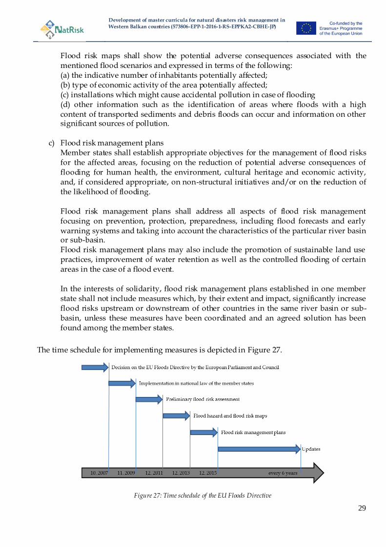
3.1.2 EU Floods Directive
The EU Floods Directive (EU Directive 2007/60/EC) on the assessment and management of flood risks came into force on 23rd of October 2007. The purpose of this directive is to establish a framework for the assessment and management of flood risks to reduce the risk of adverseconsequences, especially for human health and life, theenvironment, cultural heritage, economic activity andinfrastructure associated with floods. This directive is subdivided into three implementation measures:
a) Preliminary flood risk assessment Based on available or readily derivable information, suchas records and studies on long term developments, in particularimpacts of climate change on the occurrence of floods, a preliminaryflood risk assessment shall be undertaken to provide anassessment of potential risks. On the basis of this information member states shall identify those areas for which theyconclude that potential significant flood risks exist or mightbe considered likely to occur.
b) Flood hazard maps and flood risk maps Member States shall, at the level of the river basin district,or unit of management, prepareflood hazard maps and flood risk maps. The preparation of these mapsfor areas which are shared with other member states shall be subject to prior exchange of information. Flood hazard maps Flood hazard maps shall cover the geographical areas which could be flooded according to the following scenarios: (a) floods with a low probability, or extreme event scenarios; (b) floods with a medium probability (likely return period >= 100 years); (c) floods with a high probability, where appropriate. For each scenario the following elements shall be shown: (a) the flood extent; (b) water depths or water level, as appropriate; (c) where appropriate, the flow velocity or the relevant water flow; Flood risk maps
Development of master curricula for natural disasters risk management in
Western Balkan countries (573806-EPP-1-2016-1-RS-EPPKA2-CBHE-JP)
29
Flood risk maps shall show the potential adverse consequences associated with the mentioned flood scenarios and expressed in terms of the following: (a) the indicative number of inhabitants potentially affected; (b) type of economic activity of the area potentially affected; (c) installations which might cause accidental pollution in case of flooding (d) other information such as the identification of areas where floods with a high content of transported sediments and debris floods can occur and information on other significant sources of pollution.
c) Flood risk management plans Member states shall establish appropriate objectives for the management of flood risks for the affected areas, focusing on the reduction of potential adverse consequences of flooding for human health, the environment, cultural heritage and economic activity, and, if considered appropriate, on non-structural initiatives and/or on the reduction of the likelihood of flooding. Flood risk management plans shall address all aspects of flood risk management focusing on prevention, protection, preparedness, including flood forecasts and early warning systems and taking into account the characteristics of the particular river basin or sub-basin. Flood risk management plans may also include the promotion of sustainable land use practices, improvement of water retention as well as the controlled flooding of certain areas in the case of a flood event. In the interests of solidarity, flood risk management plans established in one member state shall not include measures which, by their extent and impact, significantly increase flood risks upstream or downstream of other countries in the same river basin or sub-basin, unless these measures have been coordinated and an agreed solution has been found among the member states.
The time schedule for implementing measures is depicted in Figure 27.
Figure 27: Time schedule of the EU Floods Directive
Development of master curricula for natural disasters risk management in
Western Balkan countries (573806-EPP-1-2016-1-RS-EPPKA2-CBHE-JP)
30
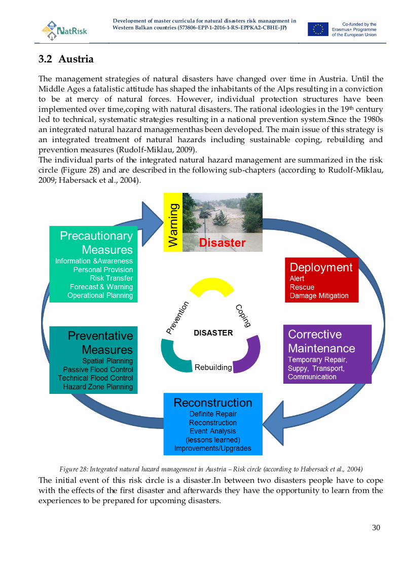
3.2 Austria
The management strategies of natural disasters have changed over time in Austria. Until the Middle Ages a fatalistic attitude has shaped the inhabitants of the Alps resulting in a conviction to be at mercy of natural forces. However, individual protection structures have been implemented over time,coping with natural disasters. The rational ideologies in the 19th century led to technical, systematic strategies resulting in a national prevention system.Since the 1980s an integrated natural hazard managementhas been developed. The main issue of this strategy is an integrated treatment of natural hazards including sustainable coping, rebuilding and prevention measures (Rudolf-Miklau, 2009). The individual parts of the integrated natural hazard management are summarized in the risk circle (Figure 28) and are described in the following sub-chapters (according to Rudolf-Miklau, 2009; Habersack et al., 2004).
Figure 28: Integrated natural hazard management in Austria – Risk circle (according to Habersack et al., 2004)
The initial event of this risk circle is a disaster.In between two disasters people have to cope with the effects of the first disaster and afterwards they have the opportunity to learn from the experiences to be prepared for upcoming disasters.

Development of master curricula for natural disasters risk management in
Western Balkan countries (573806-EPP-1-2016-1-RS-EPPKA2-CBHE-JP)
31
3.2.1 Deployment
Immediately after the natural disaster urgent measures have to be implemented. Responsible authorities (e.g. Police, fire brigade, Red Cross, Austrian Armed Forces, etc.) will be alerted in case of emergency to man and property or in case of danger to medical, technical and public safety. Additionally, emergency measures are implemented to mitigate damages. Besides the mentioned national authorities a voluntary aid organisation called ―Team Österreich‖ has been established by the radio station ―HitradioÖ3‖ and the Red Cross in the year 2007. In the meantime around 50.000 volunteers joined ―Team Österreich‖, who will be informed in case of emergency and support the national authorities (e.g. filling of sandbags, shovelling snow, clean-up exercises, childcare, etc.).
Figure 29: Emergency measures – Filling of sandbags by “Team Österreich” (Hitradio Ö3)
3.2.2 Corrective Maintenance
In the course of corrective maintenance necessary infrastructure (e.g. bridges (Figure 30), streets, power and water supply, telecommunication network, etc.) will be temporarily repaired to rehabilitate standard processes and humanitarian and financial support will be provided to affected persons.During and after the event information will be collectedincluding mapping, marks on buildings, flow paths, damage reports, photos, etc.
Figure 30: Corrective Maintenance – Temporary repair of a bridge (Bundesheer, Moser, 2009)
Development of master curricula for natural disasters risk management in
Western Balkan countries (573806-EPP-1-2016-1-RS-EPPKA2-CBHE-JP)
32
3.2.3 Reconstruction
This phase includes the definitive reconstruction of buildings, roads and infrastructure. Based on the available disaster documentations analyses and reflections of the natural disaster will be done. Committed mistakes will be evaluated and knowledge gaps will be shown to draw conclusions (―lessons learned‖) and learn for upcoming events. The gained information will be further used for the improvement or upgrade of future protection measures or strategies.
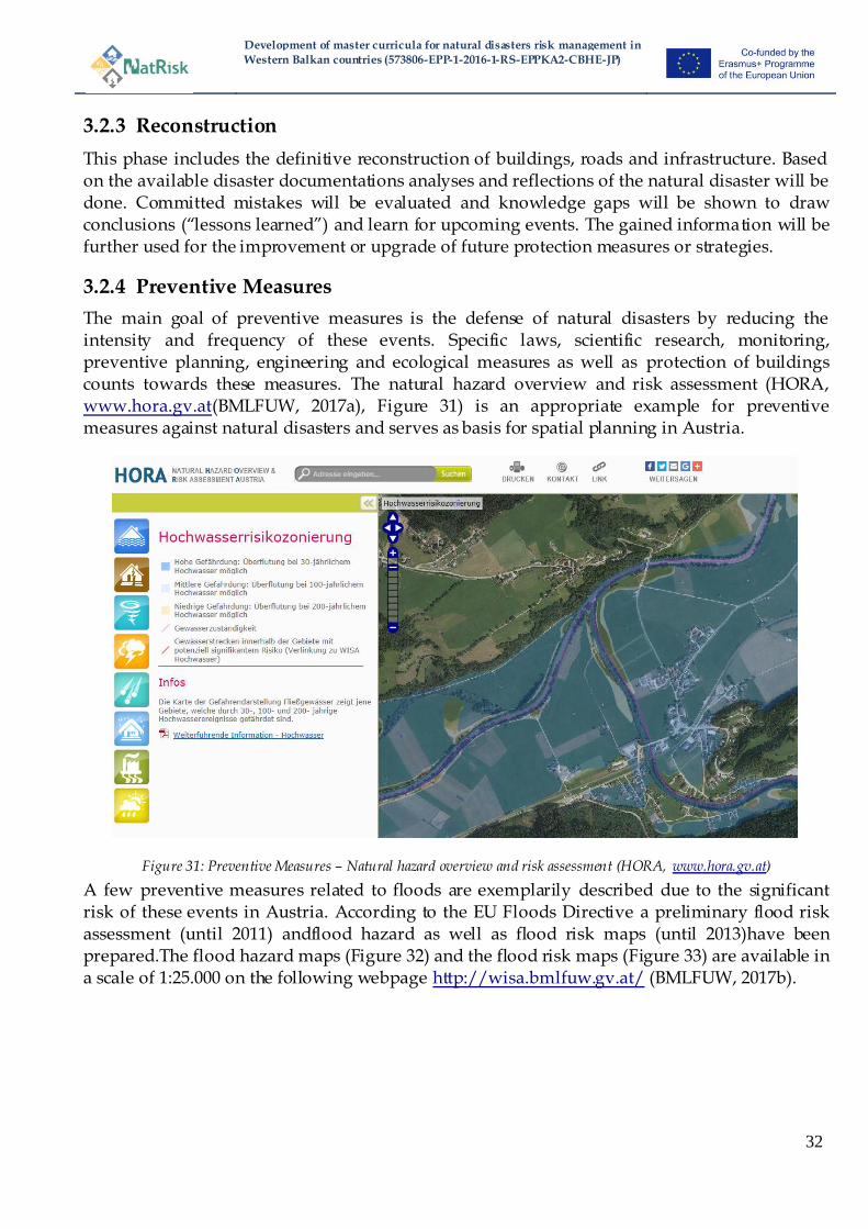
3.2.4 Preventive Measures
The main goal of preventive measures is the defense of natural disasters by reducing the intensity and frequency of these events. Specific laws, scientific research, monitoring, preventive planning, engineering and ecological measures as well as protection of buildings counts towards these measures. The natural hazard overview and risk assessment (HORA, www.hora.gv.at(BMLFUW, 2017a), Figure 31) is an appropriate example for preventive measures against natural disasters and serves as basis for spatial planning in Austria.
Figure 31: Preventive Measures – Natural hazard overview and risk assessment (HORA, www.hora.gv.at)
A few preventive measures related to floods are exemplarily described due to the significant risk of these events in Austria. According to the EU Floods Directive a preliminary flood risk assessment (until 2011) andflood hazard as well as flood risk maps (until 2013)have been prepared.The flood hazard maps (Figure 32) and the flood risk maps (Figure 33) are available in a scale of 1:25.000 on the following webpage http://wisa.bmlfuw.gv.at/ (BMLFUW, 2017b).

Development of master curricula for natural disasters risk management in
Western Balkan countries (573806-EPP-1-2016-1-RS-EPPKA2-CBHE-JP)
33
Figure 32:Preventive Measures – Flood hazard map (HORA, http://wisa.bmlfuw.gv.at/)
Figure 33:Preventive Measures – Flood risk map (HORA, http://wisa.bmlfuw.gv.at/)

Development of master curricula for natural disasters risk management in
Western Balkan countries (573806-EPP-1-2016-1-RS-EPPKA2-CBHE-JP)
34
Based on the assessment and the existing maps a national flood risk management plan – RMP (BMLFUW, 2016) has been developed until 2015. In this national flood risk management plan appropriate objectives to reduce the risk as well as measures and their ranking to reach these targets are defined. The fundamental framework of this ―RMP‖ is based on the risk circle and includes coping, rebuilding and preventing measures.
3.2.5 Precautionary measures
Precautionary measures serve as preparation for coping with upcoming natural disasters. Public information and awareness as well as risk transfer (e.g. insurances)count towards these measures. Efforts to promote personal provisions (e.g. incentives) are also included in precautionary measures. The second main part is related to measures needed to be taken shortly before a natural disaster. Weather forecast and early warning systems provide information for disaster control and emergency services, which use the generated data for operational planning.
3.3 Greece
3.3.1 Building and design requirements
The society gradually used to survive with risks, especially earthquakes, and adopted suitable measures, for example building small houses with flexible upper stories,integrating wooden elements in stone houses, leaving aseismic gaps between neighboringbuildings and so on. In the last thirty years, Greek Building Regulations have been evolved and have covered efficiently this risk, at least for houses made of reinforced concrete structural elements,new buildings and renovation of older ones. Masonry buildings, which are the majority of oldbuildings, are partially covered, since the state-of-the art of knowledge does not yet allow usfully explain the mechanical behavior and, at the same time, these buildings have beenconstructed with less or no quality control. Steel or the few wooden structures are usuallyearthquake-resistant, since they are lighter, although collapse of secondary elements during anearthquake, like glass facades, may become a risk. Special design requirements have been set up in various parts of Greece to mitigate damage potential in case of earthquakes (Figure 34).
Figure 34: Earthquake design requirements in various parts of Greece
Development of master curricula for natural disasters risk management in
Western Balkan countries (573806-EPP-1-2016-1-RS-EPPKA2-CBHE-JP)
35
Additionally periodic inspections of infrastructure are performed to prevent losses from natural hazards.
3.3.2 Weather prediction
Weather prediction services are quite well-organized in Greece. The responsible authorities work in close cooperation with international ones.
3.4 Hungary
3.4.1 Implementation of the Floods Directive
The content of the Commission Directive 2007/60/EC on the assessment and management of flood risks(26/11/2007):
Designation of managing authority Preliminary flood risk assessment (Art. 4(3))
Areas of potential significant flood risk (Art. 5(2)) – completed (2011.DEC) Flood hazard and risk maps (Art. 6(2)) – completed(2013.DEC)
Flood risk management plans (art. 8(2)) – completed (2015.DEC)
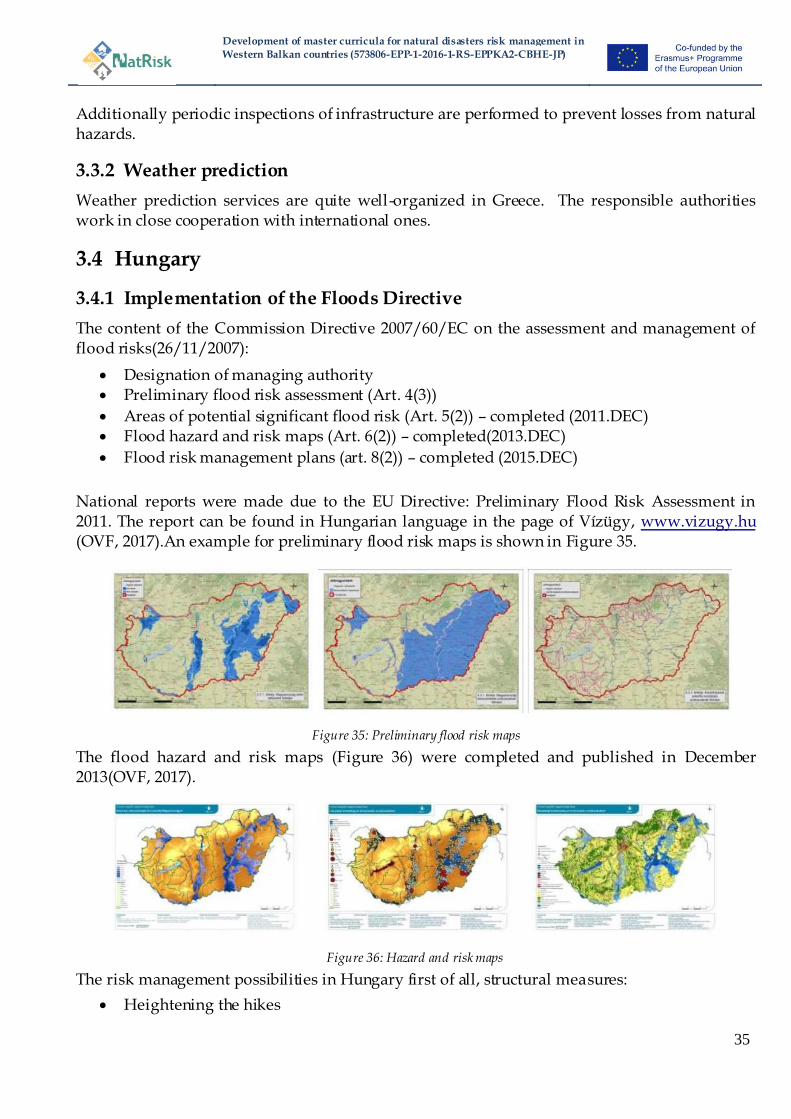
National reports were made due to the EU Directive: Preliminary Flood Risk Assessment in 2011. The report can be found in Hungarian language in the page of Vízügy, www.vizugy.hu (OVF, 2017).An example for preliminary flood risk maps is shown in Figure 35.
Figure 35: Preliminary flood risk maps
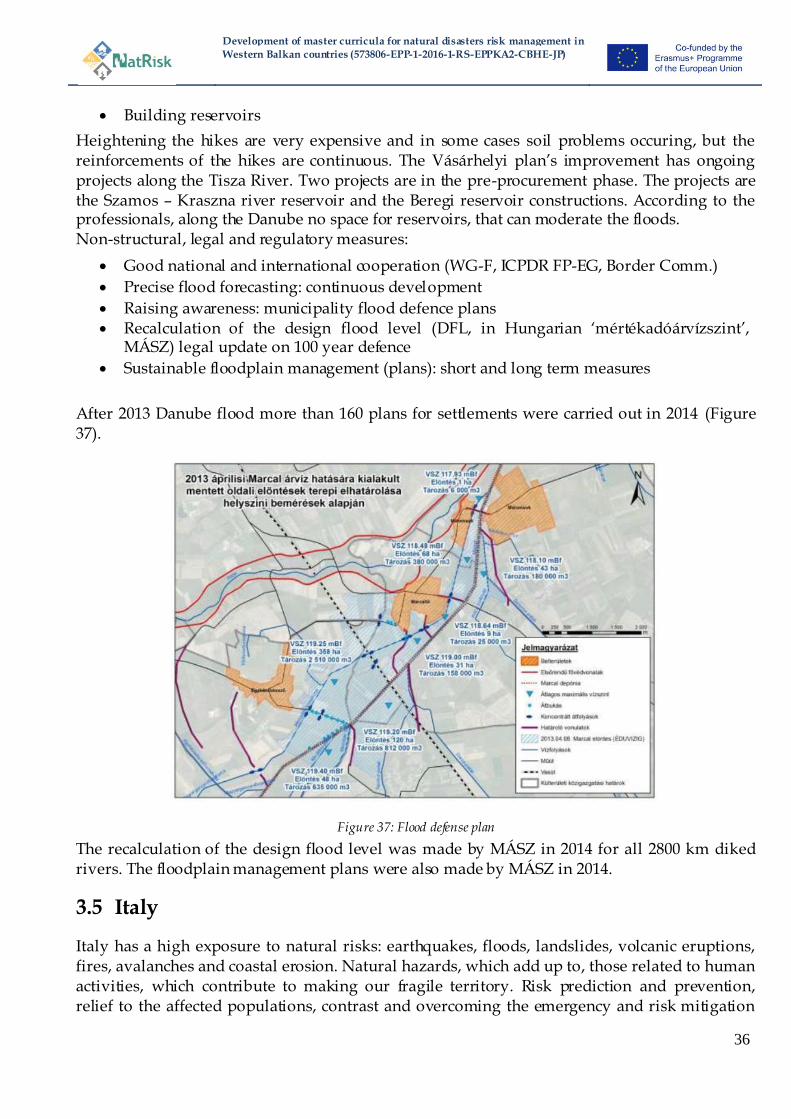
The flood hazard and risk maps (Figure 36) were completed and published in December 2013(OVF, 2017).
Figure 36: Hazard and risk maps
The risk management possibilities in Hungary first of all, structural measures:
Heightening the hikes
Development of master curricula for natural disasters risk management in
Western Balkan countries (573806-EPP-1-2016-1-RS-EPPKA2-CBHE-JP)
36
Building reservoirs
Heightening the hikes are very expensive and in some cases soil problems occuring, but the reinforcements of the hikes are continuous. The Vásárhelyi plan‘s improvement has ongoing projects along the Tisza River. Two projects are in the pre-procurement phase. The projects are the Szamos – Kraszna river reservoir and the Beregi reservoir constructions. According to the professionals, along the Danube no space for reservoirs, that can moderate the floods. Non-structural, legal and regulatory measures:
Good national and international cooperation (WG-F, ICPDR FP-EG, Border Comm.)
Precise flood forecasting: continuous development
Raising awareness: municipality flood defence plans Recalculation of the design flood level (DFL, in Hungarian ‗mértékadóárvízszint‘,
MÁSZ) legal update on 100 year defence
Sustainable floodplain management (plans): short and long term measures
After 2013 Danube flood more than 160 plans for settlements were carried out in 2014 (Figure 37).
Figure 37: Flood defense plan
The recalculation of the design flood level was made by MÁSZ in 2014 for all 2800 km diked rivers. The floodplain management plans were also made by MÁSZ in 2014.
3.5 Italy
Italy has a high exposure to natural risks: earthquakes, floods, landslides, volcanic eruptions, fires, avalanches and coastal erosion. Natural hazards, which add up to, those related to human activities, which contribute to making our fragile territory. Risk prediction and prevention, relief to the affected populations, contrast and overcoming the emergency and risk mitigation
Development of master curricula for natural disasters risk management in
Western Balkan countries (573806-EPP-1-2016-1-RS-EPPKA2-CBHE-JP)
37
are the civil protection activities identified by the Law no. 225/92, which established the National Service. Protection of people and safeguard of the territory are the main objectives of these activities - which the Department addresses, promotes and coordinates in collaboration with regional governments and local self-government. Prediction activities - carried out with the participation of relevant scientific and technical subjects - aim to assess risk scenarios and, when possible, to give notice, monitor and supervise events and risk levels expected. Early warning, planning, training, dissemination of knowledge of civil protection, information to the population, drills, and application of technical regulations are the main instruments of civil protection for the prevention of territorial risks and are intended to prevent or limit damage in the event of an emergency. Relief activities consist in the set of first assistance interventions to the affected populations. Finally, the emergency overcoming comprises all the necessary steps to remove obstacles in order to resume normal life conditions in the affected territories.
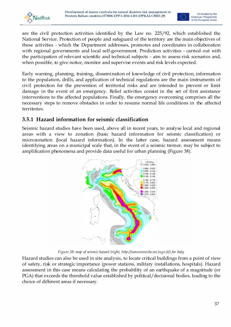
3.5.1 Hazard information for seismic classification
Seismic hazard studies have been used, above all in recent years, to analyse local and regional areas with a view to zonation (basic hazard information for seismic classification) or microzonation (local hazard information). In the latter case, hazard assessment means identifying areas on a municipal scale that, in the event of a seismic tremor, may be subject to amplification phenomena and provide data useful for urban planning (Figure 38).
Figure 38: map of seismic hazard (right, http://zonesismiche.mi.ingv.it/) for Italy
Hazard studies can also be used in site analysis, to locate critical buildings from a point of view of safety, risk or strategic importance (power stations, military installations, hospitals). Hazard assessment in this case means calculating the probability of an earthquake of a magnitude (or PGA) that exceeds the threshold value established by political/decisional bodies, leading to the choice of different areas if necessary.

Development of master curricula for natural disasters risk management in
Western Balkan countries (573806-EPP-1-2016-1-RS-EPPKA2-CBHE-JP)
38
3.5.2 River Basin Hydrogeological Plans and implementation of EU Floods Directive
The safeguard protection concept has been implemented by establishing the rules responding to the appropriate land management principles. The river basin has been identified as basic unit for developing the proper land management in an integrated, multisectorial way and through consultation. On this basis, in 1989, the first Law for the ―soil protection‖ in Italy was enacted; the Law fixed the rules for the actions needed to guarantee the hydrogeological land planning, suitable to the safety of the population, the protection of the cultural heritage, the envi ronment and human activities. Later, in 1998, in order to strengthen and enhance the previous Law, a new Act has been issued, defining the procedures to obtain a hydrogeological land planning aimed at more clearly applying the concept of safeguarding and protection. The concept of risk was introduced, occurring as a result of the combination of the hazard, the value and the vulnerability of the elements at risk. The constraints for the land use were defined with the aim of avoiding new risk and also the measures to reduce the existing risk through its classification, so identifying the degree of attention and the priority actions. The above rules and principles have been implemented by the River Basins Hydrogeological Plans which provided the following results: • hazard and risk maps for floods and landslides, showing all scenarios; • provisions regarding land use in ―high risk‖ and ―high hazard‖ areas to prevent the increasing or generation of risk; • priority actions for risk reduction, identified according to the degree of risk; On the basis of the Plans, the Map of the areas at high hydrogeological critical state has been prepared to support the priority actions. Only to face up these actions, a planned strategy of the required initiatives will be needed, to be financed by EU, National, Regional, Local and Private Funds. Italy accepted the (EU Floods Directive) in 2010 with the Decree n.49. As the Floods Directive has entered into force the implementation of the Directive is starting. The activities of the EU Floods Directive have been implemented in the eitgh river basin districts in which the national territory was divided, out of which 2 are international sharing water courses with France to the west, Switzerland and Austria to the north and Slovenia to the east. The Flood Risk Management Plans can be found on the pages of the respective competent authorities:http://www.isprambiente.gov.it/pre_meteo/idro/Piani_gest.html.
3.6 England
Disaster management has a long tradition in England and has developed in an iterative and piecemeal way over considerable centuries. As in many countries the first priority is to address issues which impact public safety and adopts principally a cost-benefit approach (CBA) to managing risks, whereby investment is targeted to those situations which can provide most
Development of master curricula for natural disasters risk management in
Western Balkan countries (573806-EPP-1-2016-1-RS-EPPKA2-CBHE-JP)
39
economic benefits, although these are often adjusted to account for other factors (e.g. environmental benefits, recognising social vulnerabilities). Importantly, there is a mix of public and private responsibility for managing disasters and although the government leads the management of many risks, individuals are also expected to take responsibility for managing their own risk. An example of this is demonstrated within the case of flood risk, whereby despite government interventions and investment, the legal responsibility for managing flood risk continues to rest with the land/property owner (Environment Agency, 2013). This has been reinforced more recently with the pol itically and resource driven move towards Localism and a shift towards increasing the proportion of funding (Partnership Funding; Defra, 2012) for flood risk management which comes from local sources (Thaler and Priest, 2014). Furthermore, due to the extent and complexity of the flood risks experienced in England it has long been recognised that it is impossible to protect all properties from all floods. Therefore, over the past 60 years or more a highly diversified strategy of risk management has develo ped (Alexander et al., 2016) which is highlighted in the many different categories described below. This approach recognises that in areas with a lower flood risk it may be more appropriate to live with flooding and develop other approaches to management including increasing community resilience and facilitating ways to absorb impact and recover. Figure 39 presented by the Environment Agency (2009a; 8) illustrates the ways in which they expect flood likelihood and impacts to both increase and decrease through management actions and future scenarios.

Development of master curricula for natural disasters risk management in
Western Balkan countries (573806-EPP-1-2016-1-RS-EPPKA2-CBHE-JP)
40
Figure 39: Managing flood risk – addressing likelihoods and impacts (Environment Agency, 2009a; 8)
3.6.1 Prevention: Spatial planning and development control
England has a long-standing and well-developed approach to spatial planning and development control which aims to minimise the exposure of people by prohibiting or discouraging inappropriate development in areas susceptible to flooding. This approach was strengthened in 2001 with the first iteration of the indicative flood map (Priest et al., 2008) which provided a means for spatial planners to identify flood risk. The ‗Flood Map for Planning‘ is still a product offered by the Environment Agency (see Figure 40). Principally, England has a non-zoning discursive approach to spatial planning and any (re)developments are required to submit a planning application locally and receive planning consent prior to their construction. Therefore, spatial planning is primarily undertaken at local levels, although decisions are required to be consistent with national planning policy. The National Planning Policy Framework (NPPF) (DCLG, 2012) includes flood risk as a
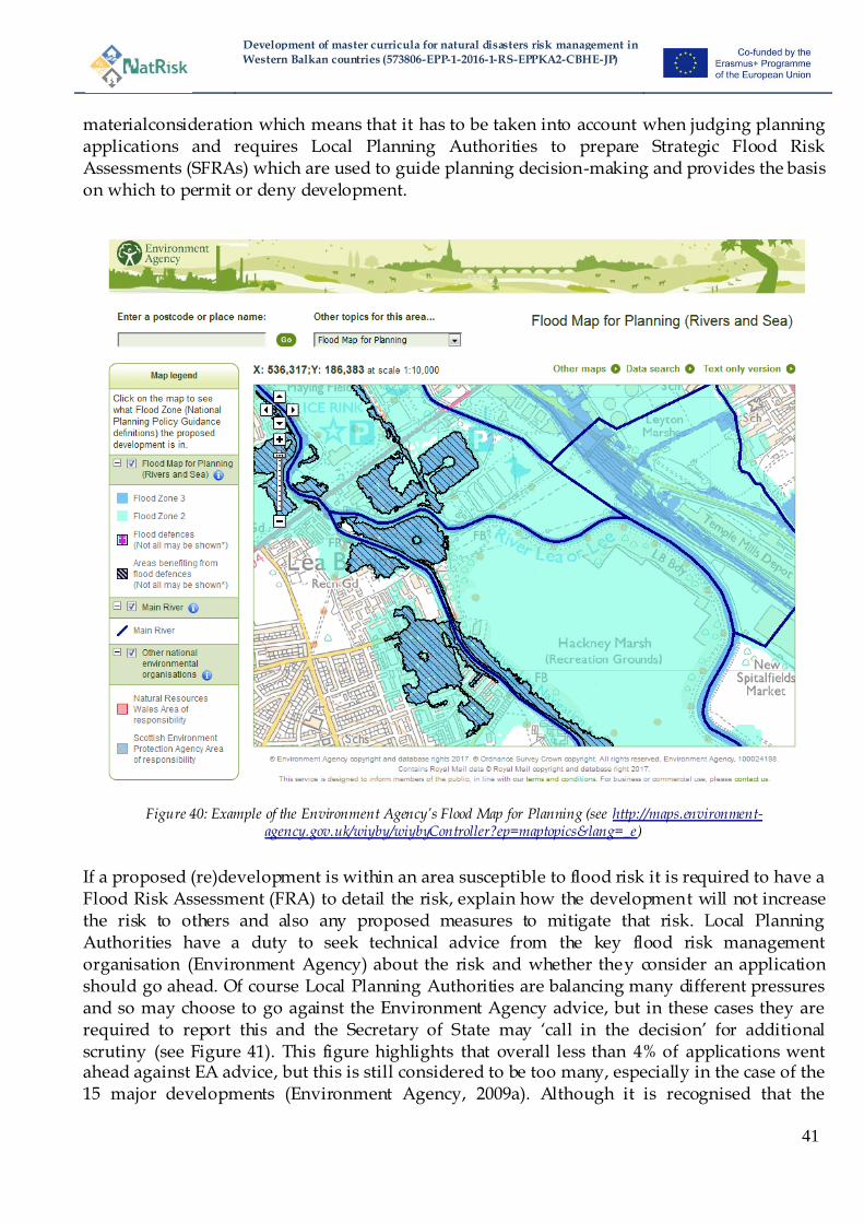
Development of master curricula for natural disasters risk management in
Western Balkan countries (573806-EPP-1-2016-1-RS-EPPKA2-CBHE-JP)
41
materialconsideration which means that it has to be taken into account when judging planning applications and requires Local Planning Authorities to prepare Strategic Flood Risk Assessments (SFRAs) which are used to guide planning decision-making and provides the basis on which to permit or deny development.
Figure 40: Example of the Environment Agency‟s Flood Map for Planning (see http://maps.environment-agency.gov.uk/wiyby/wiybyController?ep=maptopics&lang=_e)
If a proposed (re)development is within an area susceptible to flood risk it is required to have a Flood Risk Assessment (FRA) to detail the risk, explain how the development will not increase the risk to others and also any proposed measures to mitigate that risk. Local Planning Authorities have a duty to seek technical advice from the key flood risk management organisation (Environment Agency) about the risk and whether they consider an application should go ahead. Of course Local Planning Authorities are balancing many different pressures and so may choose to go against the Environment Agency advice, but in these cases they are required to report this and the Secretary of State may ‗call in the decision‘ for additional scrutiny (see Figure 41). This figure highlights that overall less than 4% of applications went ahead against EA advice, but this is still considered to be too many, especially in the case of the 15 major developments (Environment Agency, 2009a). Although it is recognised that the
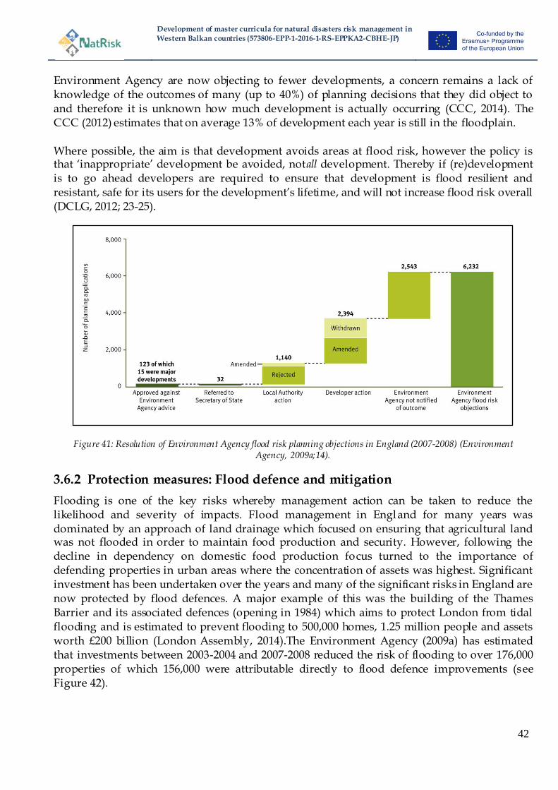
Development of master curricula for natural disasters risk management in
Western Balkan countries (573806-EPP-1-2016-1-RS-EPPKA2-CBHE-JP)
42
Environment Agency are now objecting to fewer developments, a concern remains a lack of knowledge of the outcomes of many (up to 40%) of planning decisions that they did object to and therefore it is unknown how much development is actually occurring (CCC, 2014). The CCC (2012) estimates that on average 13% of development each year is still in the floodplain. Where possible, the aim is that development avoids areas at flood risk, however the policy is that ‗inappropriate‘ development be avoided, notall development. Thereby if (re)development is to go ahead developers are required to ensure that development is flood resilient and resistant, safe for its users for the development‘s lifetime, and will not increase flood risk overall (DCLG, 2012; 23-25).
Figure 41: Resolution of Environment Agency flood risk planning objections in England (2007-2008) (Environment Agency, 2009a;14).
3.6.2 Protection measures: Flood defence and mitigation
Flooding is one of the key risks whereby management action can be taken to reduce the likelihood and severity of impacts. Flood management in England for many years was dominated by an approach of land drainage which focused on ensuring that agricultural land was not flooded in order to maintain food production and security. However, following the decline in dependency on domestic food production focus turned to the importance of defending properties in urban areas where the concentration of assets was highest. Significant investment has been undertaken over the years and many of the significant risks in England are now protected by flood defences. A major example of this was the building of the Thames Barrier and its associated defences (opening in 1984) which aims to protect London from tidal flooding and is estimated to prevent flooding to 500,000 homes, 1.25 million people and assets worth £200 billion (London Assembly, 2014).The Environment Agency (2009a) has estimated that investments between 2003-2004 and 2007-2008 reduced the risk of flooding to over 176,000 properties of which 156,000 were attributable directly to flood defence improvements (see Figure 42).
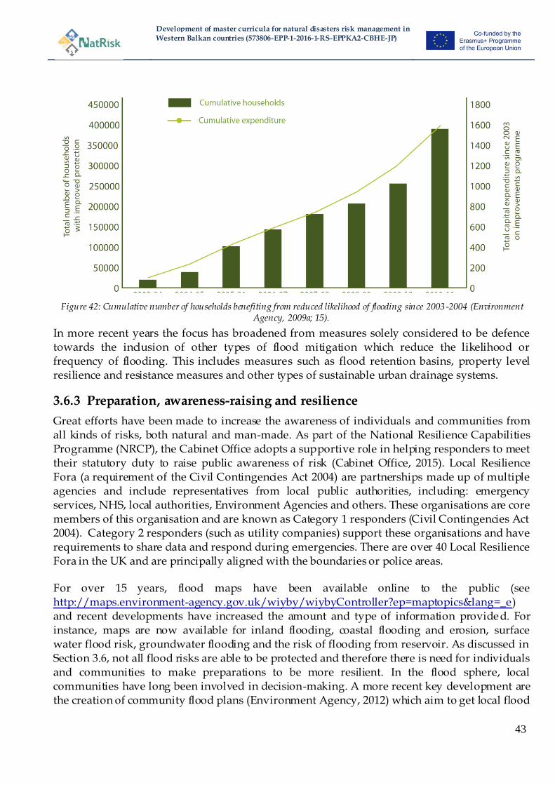
Development of master curricula for natural disasters risk management in
Western Balkan countries (573806-EPP-1-2016-1-RS-EPPKA2-CBHE-JP)
43
Figure 42: Cumulative number of households benefiting from reduced likelihood of flooding since 2003-2004 (Environment Agency, 2009a; 15).
In more recent years the focus has broadened from measures solely considered to be defence towards the inclusion of other types of flood mitigation which reduce the likelihood or frequency of flooding. This includes measures such as flood retention basins, property level resilience and resistance measures and other types of sustainable urban drainage systems.
3.6.3 Preparation, awareness-raising and resilience
Great efforts have been made to increase the awareness of individuals and communities from all kinds of risks, both natural and man-made. As part of the National Resilience Capabilities Programme (NRCP), the Cabinet Office adopts a supportive role in helping responders to meet their statutory duty to raise public awareness of risk (Cabinet Office, 2015). Local Resilience Fora (a requirement of the Civil Contingencies Act 2004) are partnerships made up of multiple agencies and include representatives from local public authorities, including: emergency services, NHS, local authorities, Environment Agencies and others. These organisations are core members of this organisation and are known as Category 1 responders (Civil Contingencies Act 2004). Category 2 responders (such as utility companies) support these organisations and have requirements to share data and respond during emergencies. There are over 40 Local Resilience Fora in the UK and are principally aligned with the boundaries or police areas. For over 15 years, flood maps have been available online to the public (see http://maps.environment-agency.gov.uk/wiyby/wiybyController?ep=maptopics&lang=_e) and recent developments have increased the amount and type of information provided. For instance, maps are now available for inland flooding, coastal flooding and erosion, surface water flood risk, groundwater flooding and the risk of flooding from reservoir. As discussed in Section 3.6, not all flood risks are able to be protected and therefore there is need for individuals and communities to make preparations to be more resilient. In the flood sphere, local communities have long been involved in decision-making. A more recent key development are the creation of community flood plans (Environment Agency, 2012) which aim to get local flood
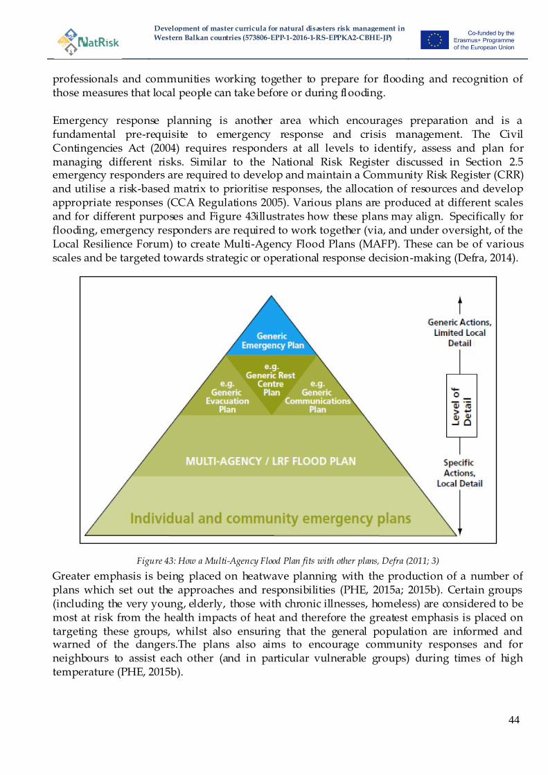
Development of master curricula for natural disasters risk management in
Western Balkan countries (573806-EPP-1-2016-1-RS-EPPKA2-CBHE-JP)
44
professionals and communities working together to prepare for flooding and recognition of those measures that local people can take before or during flooding. Emergency response planning is another area which encourages preparation and is a fundamental pre-requisite to emergency response and crisis management. The Civil Contingencies Act (2004) requires responders at all levels to identify, assess and plan for managing different risks. Similar to the National Risk Register discussed in Section 2.5 emergency responders are required to develop and maintain a Community Risk Register (CRR) and utilise a risk-based matrix to prioritise responses, the allocation of resources and develop appropriate responses (CCA Regulations 2005). Various plans are produced at different scales and for different purposes and Figure 43illustrates how these plans may align. Specifically for flooding, emergency responders are required to work together (via, and under oversight, of the Local Resilience Forum) to create Multi-Agency Flood Plans (MAFP). These can be of various scales and be targeted towards strategic or operational response decision-making (Defra, 2014).
Figure 43: How a Multi-Agency Flood Plan fits with other plans, Defra (2011; 3)
Greater emphasis is being placed on heatwave planning with the production of a number of plans which set out the approaches and responsibilities (PHE, 2015a; 2015b). Certain groups (including the very young, elderly, those with chronic illnesses, homeless) are considered to be most at risk from the health impacts of heat and therefore the greatest emphasis is placed on targeting these groups, whilst also ensuring that the general population are informed and warned of the dangers.The plans also aims to encourage community responses and for neighbours to assist each other (and in particular vulnerable groups) during times of high temperature (PHE, 2015b).

Development of master curricula for natural disasters risk management in
Western Balkan countries (573806-EPP-1-2016-1-RS-EPPKA2-CBHE-JP)
45
3.6.4 Response and crisis management
The Civil Contingencies Act 2004 is the fundamental legislation which governs crisis management and response during disasters. As described in Section 3.6.3 this principally requires a whole range of different authorities planning and working together to respond. Like most countries, the principal of subsidiarity pervades this area and the response and crisis management responsibilities and actions vary depending on the severity of the event and its scale. Across all types of emergency events, integrated emergency response is key and is coordinated through a tiered command structure, convened at operational (hands on response), tactical (Tactial Co-ordinating Group (TCG)) and strategic(for emergencies with high severity or
geographical spread a Strategic Co-ordinating Group (SCG)) levels. Strategic decision-making is essentially concerned with the ―bigger picture‖ and involve difficult decisions about the allocation and prioritisation of response resources. Often, the SCG (and TCG) is often chaired by a representative from the Police or LA Chief Executive and will be attended by representatives for all Category 1 Responders. Crucially, within these multi -agency coordinating groups, no single responding agency has command control (HM Government, 2012). In the UK, emergencies are categorised into 3 levels indicating different levels of Government involvement. Figure 44 illustrates these trigger levels and some examples of natural and other events which fit into each category. For levels 2 (serious) and 3 (catastrophic) the government plays a strategic coordinating role and COBR (Cabinet Office Briefing Room) would be established and there will be a higher degree of reporting to government. For Level 3 the Civil Contingencies Secretariat (CCS) coordinates a centralised response.
Figure 44: UK emergency levels and their trigger levels (Defra, 2014; 10)
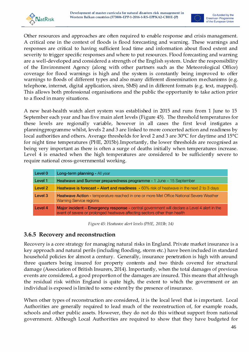
Development of master curricula for natural disasters risk management in
Western Balkan countries (573806-EPP-1-2016-1-RS-EPPKA2-CBHE-JP)
46
Other resources and approaches are often required to enable response and crisis management. A critical one in the context of floods is flood forecasting and warning. These warnings and responses are critical to having sufficient lead time and information about flood extent and severity to trigger specific responses and where to put resources. Flood forecasting and warning are a well-developed and considered a strength of the English system. Under the responsibility of the Environment Agency (along with other partners such as the Meteorological Office) coverage for flood warnings is high and the system is constantly being improved to offer warnings to floods of different types and also many different dissemination mechanisms (e.g. telephone, internet, digital application, siren, SMS) and in different formats (e.g. text, mapped). This allows both professional organisations and the public the opportunity to take action prior to a flood in many situations. A new heat-health watch alert system was established in 2015 and runs from 1 June to 15 September each year and has five main alert levels (Figure 45). The threshold temperatures for these levels are regionally variable, however in all cases the first level instigates a planningprogramme whilst, levels 2 and 3 are linked to more concerted action and readiness by local authorities and others. Average thresholds for level 2 and 3 are 30°C for daytime and 15°C for night time temperatures (PHE, 2015b).Importantly, the lower thresholds are recognised as being very important as there is often a surge of deaths initially when temperatures increase. Level 4 is enacted when the high temperatures are considered to be sufficiently severe to require national cross-governmental working.
Figure 45: Heatwave alert levels (PHE, 2015b; 14)
3.6.5 Recovery and reconstruction
Recovery is a core strategy for managing natural risks in England. Private market insurance is a key approach and natural perils (including flooding, storm etc.) have been included in standard household policies for almost a century. Generally, insurance penetration is high with around three quarters being insured for property contents and two thirds covered for structural damage (Association of British Insurers, 2014). Importantly, when the total damages of previous events are considered, a good proportion of the damages are insured. This means that although the residual risk within England is quite high, the extent to which the government or an individual is exposed is limited to some extent by the presence of insurance. When other types of reconstruction are considered, it is the local level that is i mportant. Local Authorities are generally required to lead much of the reconstruction of, for example roads, schools and other public assets. However, they do not do this without support from national government. Although Local Authorities are required to show that they have budgeted for

Development of master curricula for natural disasters risk management in
Western Balkan countries (573806-EPP-1-2016-1-RS-EPPKA2-CBHE-JP)
47
these types of losses and are encouraged to take out insurance to cover any losses, they are permitted to recover some of the uninsurable costs for some events from national government. Under the Bellwin Scheme (DCLG, 2013) the government can designate an event and open the scheme to claims for funding assistance from Local Authorities, police and fire authorities according to set criteria. Furthermore, there are often other organisations are involved within reconstructio n following a natural risk, depending upon the damages which are faced. This may include damage to major roads (Highways Agency), rail (Network rail), hospitals (NHS trusts), water companies or other private organisations.
4 Analysis of responsible institutes
The responsible authority for implementing risk management of natural disasters differs from one country to another. Responsible institutes for coping, rebuilding and prevention practices are described in the following chapter. Additionally, the qualifications of their staff are outlined and any lack of qualified employees is pointed out.
4.1 Austria
In the existing organizational structures of the national natural hazards management, the tension between "central control" and "local action" becomes apparent as three prerequisites must be fulfilled simultaneously for optimal coping, rebuilding and prevention of natural catastrophes: Regional presence, immediate availability of necessary resources and coordinated action by all stakeholders. The balancing act between ―central control‖ and ―local action‖ is subject to the national organizational principles, the federal principles and subsidiarity principles. Additionally to the governmental organization, private institutes (insurances, associations, media, citizens, etc.) contribute to the natural hazards management. A successful, integrated risk management has to consider the mentioned boundary conditions and distribute responsibilities and tasks in all conscience.
Figure 46: Organizational structure of natural hazards management in Austria
Natural hazardsmanagement
Federal administrati
on
Provincialadministrati
on
Municipaladministrati
on
General pu
blic
Insurance compani
es
Science
s
NG
Os

Development of master curricula for natural disasters risk management in
Western Balkan countries (573806-EPP-1-2016-1-RS-EPPKA2-CBHE-JP)
48
4.1.1 Federal administration
The federal administration focuses on prevention measures in the natural hazards management including the consideration of Water Act, forest law, traffic law and public health care. Related federal authorities are listed below:
Railway agency Cableway agency
Highway agency Security policy
Health care agency
Related public-sector institutions and special services are listed below:
Central Institution for Meteorology and Geodynamics (ZAMG) www.zamg.ac.at
Federal Geological Office (GBA) www.geologie.ac.at
Central Hydrographical Bureau www.wassernet.at
Federal Agency for Water Management (BAW) www.baw.at
Federal Research and Training Centre for Forests, Natural Hazards and Landscape (BFW) http://bfw.ac.at
Forest Engineering Service in Torrent and Avalanche Control (WLV) www.die-wildbach.at
Federal Water Engineering Administration (BWV) Federal Waterway Administration (via donau)
www.via-donau.org
Civil Defense, Civil Protection, and Disaster Management (BWZ) http://www.bmi.gv.at/cms/BMI_Zivilschutz_en/
All mentioned authorities, public-sector institutions and special services are governed by different federal Ministries:
Ministry of Finance (BMF)
Ministry of Agriculture, Forestry, Environment and Water Management (BMLFUW) Ministry for Transport, Innovation and Technology (BMVIT)
Ministry for the Interior (BMI), Ministry of National Defence and Sport (BMLVS) Ministry of Science, Research and Economy (BMWFW) Ministry of Labour, Social Affairs and Consumer Protection (BMASK)
Ministry for Europe, Integration and Foreign Affairs (BMEIA)

Development of master curricula for natural disasters risk management in
Western Balkan countries (573806-EPP-1-2016-1-RS-EPPKA2-CBHE-JP)
49
4.1.2 Provincial administration
The provincial administration focuses on coping measures in the natural hazards management including spatial planning, disaster management and fire brigades, which are enshrined in provincial laws.Additionally, official tasks related to federal laws (e.g. Water Act, forest law, environmental impact assessment, etc.) are executed by provincial administration. Related provincial authorities are listed below:
Forestry authority
Water authority
Environmental authority Nature Conservation authority
Regional Planning authority Transport authority Disaster Control authority
Related public-sector institutions and special services are listed below and are available in each of the nine Austrian provinces:
Hydrographic Services (HD)
Federal Water Engineering Administration (BWV) (branch office in each province) Forest Services (LFD)
Provincial Road Administration Provincial Geology
Provincial Warning Centre (LWZ) Avalanche Warning Service (LWD)
Information on all mentioned authorities, public-sector institutions and special services are available on the official websites of the nine Austrian provinces.
4.1.3 Municipal administration
The municipal administration focuses on the execution of federal and provincial laws related to measures in the municipal district including traffic police, fire brigade, building inspection and health care. Related municipal authorities are listed below:
Building authority
Related public-sector institutions and special services are listed below and are available in each of the 2100 municipalities in Austria:
Mayor Avalanche Commission
Development of master curricula for natural disasters risk management in
Western Balkan countries (573806-EPP-1-2016-1-RS-EPPKA2-CBHE-JP)
50
Information on mentioned authorities, public-sector institutions and special services are available on the official websites of the municipalities.
4.1.4 General public
The most important services of the population in connection with natural hazards are personal provision and behavioral provision as well as self-help in emergency and disaster situations (Rudolf-Miklau, 2009).
4.1.5 Media
Media are important multipliers of knowledge about natural hazards and are used to spread information during disasters. The dissemination of calls and announcements by federal and provincial authorities in case of a disaster is foreseen by law (Media Act and ORF Act) (Rudolf-Miklau, 2009).
4.1.6 Insurance companies
Private insurance companies provide an opportunity for the risk transfer of natural catastrophes. However, this opportunity has rarely been established in Austria, due to the fact that federal disaster funds are available in case of emergency. Exceptions here are storm and hail insurances, which are common in Austria (Rudolf-Miklau, 2009).
4.1.7 Science and standardisation institutes
Due to the high relevance of natural disasters a lot of public and private scientific research institutes focus on this important and interdisciplinary topic in Austria. The University of Natural Resources and Life Sciences, Vienna (BOKU), Vienna University of Technology (TU Wien), Graz University of Technology (TU Graz) and University of Innsbruck (UIBK) are prominent representatives of research institutes. In cooperation with federal and provinci al authorities projects are managed to clarify outstanding scientific issues. In addition, standards and guidelines related to natural disasters are developed by federal agencies(Rudolf-Miklau, 2009).
4.1.8 NGOs
Non-governmental organizations (NGO), which are working in the field of environmental protection, concentrate on research on natural disasters, due to their high impact on the environment. Prominent representatives of NGOs in Austria are CIPRA, Austrian Alpine Association (ÖAV), WWF, Greenpeace and Austrian League of Nature Conservation(Rudolf-Miklau, 2009).
4.2 Greece
4.2.1 Civil protection agency
A civil protection agency of the Greek Ministry of Interior Affairs, coordinates all civil
protection measures in the country and informs citizens and civil authorities involved in this

Development of master curricula for natural disasters risk management in
Western Balkan countries (573806-EPP-1-2016-1-RS-EPPKA2-CBHE-JP)
51
issue. The agency has an informative web site in several languages,
http://civilprotection.gr/en, where further information can be found.
4.2.2 Weather forecast and warning
Weather forecast and warning is coordinated by the Hellenic Weather Forecast authority, their
web side in Greek/English provide relevant information
http://www.hnms.gr/hnms/english/index_html.
4.2.3 Organization for Aseismic Design and Protection
The Organization for Aseismic Design and Protection (oasp), coordinates earthquake design,
and information for citizents in Greece, see http://www.oasp.gr/ (use Google translation
integrated in the page in order to see the material in several languages). An online system for
tracking earthquake activity has been created by the geophysical laboratory of the University of
Athens http://www.geophysics.geol.uoa.gr/stations/maps/recent.html
4.3 Hungary
The highest level of planning and coordination of disaster related actions is the government. The minister of interior is responsible for disaster management (the NDGM belongs to this ministry). The Coordination Steering Committee for Disaster Management (KKB, from 01.2012 the name was changed) is an intergovernmental committee (with several expert teams, members are ministers, the head is the premier) and coordinates the highest level decision making allowing for cooperation among several involved institutions. The structure of disaster management in Hungary can be found in Figure 47.
Figure 47:Thestructureofdisastermanagement in Hungary

Development of master curricula for natural disasters risk management in
Western Balkan countries (573806-EPP-1-2016-1-RS-EPPKA2-CBHE-JP)
52
At regional and local levels, the county and local defense boards are in charge of decision making for crisis response and preparation (the structure of the boards was changed from 2012). Defense boards are under central coordination; the members are stakeholders (local authorities, representatives of disaster management authorities, army, police, health care system, water management system (Disaster Management Law 9-17 §). At the local level, crisis preparation and response is the mayor‘s responsibility. During a special order event, the mayor or the leader of the general assembly have the decision-making power, without the necessity of calling for the defense boards (at local level the representative of the disaster management authorities can replace the mayor in decision making (Disaster Management Law 46§). Local and regional defense boards coordinate the preparation, planning and response in the fields of their competence. Official disaster management authorities are under the supervision of the minister of interior. The minister of interior is in charge of running the official disaster management institutions, and preparing reports on risk assessment and disaster management planning and performance to Parliament (DM Law 8 §). The disaster management authorities are the following: the NDGDM (central body with competence for the whole country), regional (county) directorates of disaster management (regional bodies, under the supervision of the central body), local branches and disaster management post (see Figure 47). These institutions are primarily in charge of professional disaster preparation and response, coordinating the activities of stakeholders in disaster management. There are other stakeholders and cooperating organizations – among these the Hungarian army forces, rescue institutions, the national meteorological services and rescue NGO‘s. These institutions have agreements with the disaster management authority. Disaster management institutions are centralized, though primary response and planning rests at the local level (with the mayors), supervising and coordination is the task of the disaster management authorities. Within the official disaster management hierarchy, leaders are appointed on a top-down basis (Figure 48); though initiatives are accepted from the local levels as well (website of NDGDM). In the governance of disaster management, also the top down approach is dominant, e.g. the government decides about the guidelines of disaster prevention, education and response, and coordinates the work of county defense boards and these boards coordinate the actions of local defense boards (DM Law 6-14§).
Figure 48: Disaster management authorities in Hungary

Development of master curricula for natural disasters risk management in
Western Balkan countries (573806-EPP-1-2016-1-RS-EPPKA2-CBHE-JP)
53
4.4 Italy
The National Department of Civil Protection of Prime Minister Office, coordinates all civil protection measures in the country and informs citizens and civil authorities involved in this issue. The agency has an informative web site (http://www.protezionecivile.gov.it/jcms/it/home.wp) in Italian and in English, where further information can be found. The Functional Centre for the Hydro-meteorologicalRisk (http://www.protezionecivile.gov.it/jcms/it/cfcri.wp) is the branch of the National Department of Civil Protection in charge for weather forecast and warning of extreme events as rainstorms, floods, landslides, etc. Earthquake monitoring is officialy carried out by National Insititute for Geophysiscs and Vulcanology (INGV) which provide in real time (and after any event) all the information (as magnitude, localisation, etc) regarding any sesimic event occurred in Italy (http://terremoti.ingv.it/it/)
4.5 England
The management and response to natural risks in England has developed in quite a piecemeal way over many decades. It displays various modes of governance ranging from functions which are highly centralised and controlled by central government, right though to encouraging individuals to take responsibility for their own risks (Alexander et al., 2016). In many cases, there has been a pulling back of centralised control of central government and a move towards encouraging responsibilities at the local level. This recognises that although a consistent national policy may be desirable and necessary, often decisions need to recognise local conditions and involve local experts. As previously mentioned, the principle of subsidiarity is important (especially in crisis management) with responsibility resting with those closest to relevant scale of the event that is occurring. The role of the private market in managing risks is long established in England with the role of the insurance industry, however the privatisation of water companies in the 1980s and a desire to enhance public-private partnerships has meant a greater role for private actors and the greater inclusion of market principles within risk management. The piecemeal development of roles and responsibilities and the broadening of the number of actors identified as having a stake and expertise in natural risk management have led to a complex mix of organisations at different levels with varying roles and responsibilities. Alexander et al. (2016) summarise this complexity and the administrative structure that exists for English flood risk management.
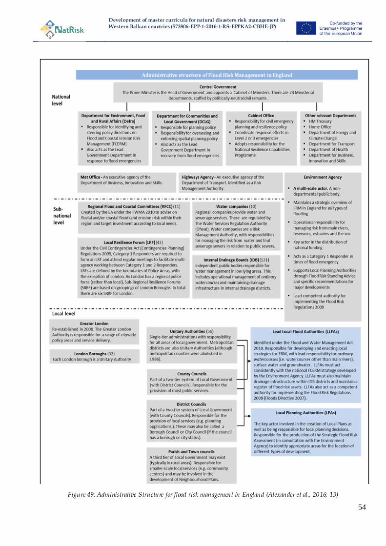
Development of master curricula for natural disasters risk management in
Western Balkan countries (573806-EPP-1-2016-1-RS-EPPKA2-CBHE-JP)
54
Figure 49: Administrative Structure for flood risk management in England (Alexander et al., 2016; 13)
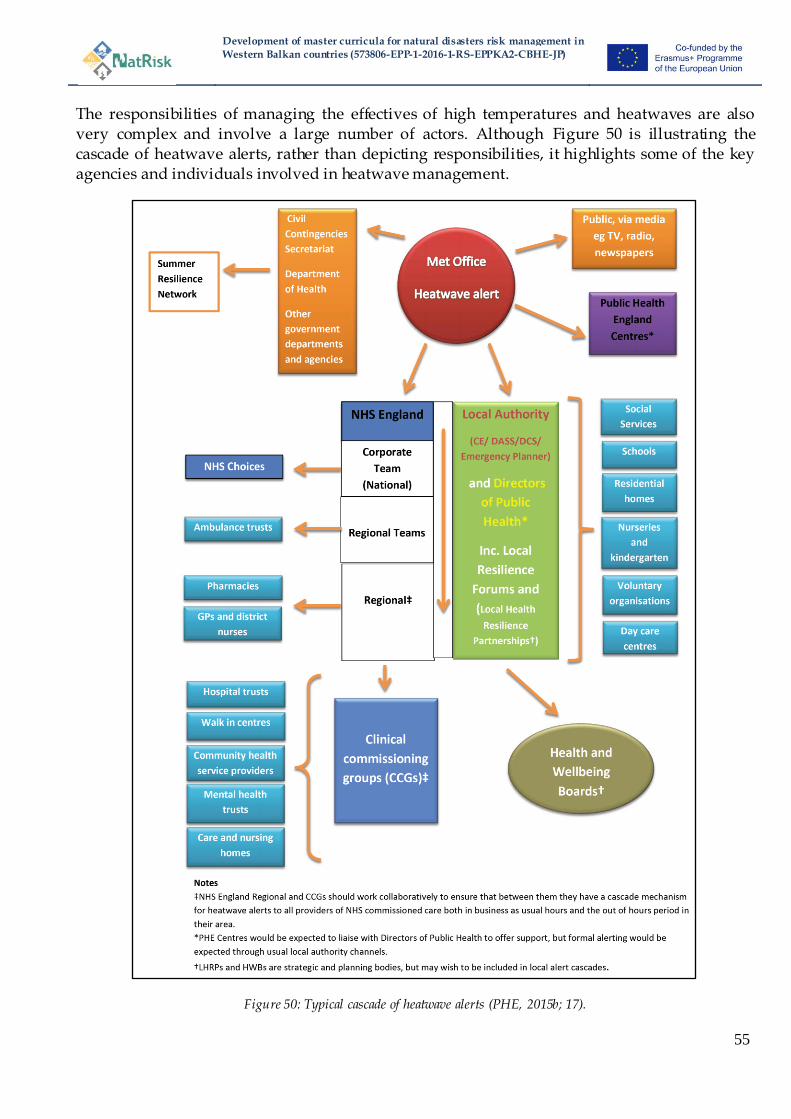
Development of master curricula for natural disasters risk management in
Western Balkan countries (573806-EPP-1-2016-1-RS-EPPKA2-CBHE-JP)
55
The responsibilities of managing the effectives of high temperatures and heatwaves are also very complex and involve a large number of actors. Although Figure 50 is illustrating the cascade of heatwave alerts, rather than depicting responsibilities, it highlights some of the key agencies and individuals involved in heatwave management.
Figure 50: Typical cascade of heatwave alerts (PHE, 2015b; 17).
Development of master curricula for natural disasters risk management in
Western Balkan countries (573806-EPP-1-2016-1-RS-EPPKA2-CBHE-JP)
56
4.5.1 National management
A wide range of different government agencies have responsibilities for the management of different aspects of natural risks. They are required to enact and have different responsibilities under a whole host of different pieces of legislation and/or their associated regulations and policies. This includes (but is in no way limited to) the Reservoirs Act 1975, Town and Country Planning Act 1990, Land Drainage Act 1991, Civil Contingencies Act 2004, Flood RiskRegulations 2009, Flood and Water Management Act 2010. The Flood and Water Management Act 2010 principally transposed the Floods Directive in England (along with the Flood Risk Regulations 2009). The lead governmental agencies vary depending upon the type of management (i.e. crisis management, planning, proactive response) and may vary depending upon the specific natural risk. Principally, but not exclusively, the national level is responsible for setting policies, whereas operational actions are more often undertaken at more local levels. Key governmental ministries/Agencies with responsibilities for some aspects of natural risk management:
Department for Environment, Food and Rural Affairs (Defra) – Lead government department for flooding: flood, coastal erosion risk, response to flood emergencies;
Department for Communities and Local Government (DCLG) – Planning policy, Recovery (administers the Bellwin Scheme), co-ordinates fire service assets;
Cabinet Office – civil emergency planning, response co-ordination for Level 2 and 3 emergencies. The Civil Contingencies Secretariat – the department of the Cabinet Office responsible for emergency planning;
HM Treasury – set rules of funding and investment; Department for Transport – would be responsible for elements of disaster planning and
response related to transport networks;
Department of Health – policy and planning related to health-related impacts (e.g. heatwaves etc.), initiate and direct the government health response and ensure that resources are available;
Department for Business, Energy and Industrial Strategy (BEIS) – oversees the Meteorological Office and Climate change policy and also will liaise with certain sectors (e.g. telecommunications) to ensure their preparation;
Ministry of Defence – there are no official duties and responsibilities but they may be
called upon during an emergency to provide assistance;
Related public-sector organisations
Highways Agency – identified as a risk management authority under the Civil Contingencies Act (2004);
Public Health England – an executive agency of the department for health which assesses health risks and provides guidance on preventing the health impacts of flood
and heatwaves;
Key role of the Environment Agency
The Environment Agency (EA) is a non-departmental public organisation which works under the supervision of the Department for Environment, Food and Rural Affairs (Defra) and is the competent authority for many of the Floods Directive functions. It has many permissive powers
Development of master curricula for natural disasters risk management in
Western Balkan countries (573806-EPP-1-2016-1-RS-EPPKA2-CBHE-JP)
57
(but not statutory obligations) and is the key operating agency as well as having the strategic overview for flood risk management. It has responsibilities for managing ‗main rivers‘ and also a supervisory role for overseeing others (such as internal drainage boards and local authorities) who manage watercourses. The EA also has responsibilities for flood forecasting and warning, to responding during flooding, for mapping flood risk, raising public awareness of flooding and assisting communities to be more resilient. Importantly, in the context of flood risk management, the EA work at both the national level (more strategic roles) and the local level (more operational roles) and herein will appear under both headings. Since their inception in 1996 the Environment Agency have become the lead experts in flood risk management, have assumed more permissive powers and have undertaken to adopt a more holistic approach to managing flooding. Another national-level organisation that plays a role is the Meteorological Office which is the national weather service and is an executive agency of the Department for Business, Energy and Industrial Strategy. This organisation will provide valuable forecasting information about many natural risks (e.g. floods, storms, heatwaves, etc.) and guidance and warnings are based on these predictions. In particular in recent years there has been a much closer working relationship between the Met Office and the Environment Agency with the creation in 2009 of a jointly–run Flood Forecasting Centre (Defra, 2014).
4.5.2 Local-level management
Local level management is a key area for the management of natural risks in England and herein the term local means anything that is not considered to be a national -level agency. Significantly, however this includes organisations and agencies with differing geographical boundaries and of different sizes (i.e. there are various types of Local Authority (municipality) for historical reasons: see Figure 49). Furthermore, this level is characterised by the presence of actors which have been specifically created/designated for natural risk management functions and others where the management of natural risks is only part of their role and responsibilities. The enactment of the Flood and Water Management Act (FWMA) 2010, following the implementation of the Floods Directive and the recommendation of the independent review of the 2007 floods (Pitt, 2008), clarified management responsibilities particularly at the local level. These responsibilities reflect the view presented above that local actors have a greater role to play in both the decision-making and funding of flood risk management. The FWMA 2010established Lead Local Flood Authorities (LLFAs) which comprise one or more LocalAuthorities (see Figure 49) and is the competent authority for some functions under the Floods Directive. LFFAs are now responsible for planning and implementing local strategies for manging flooding from surface water, groundwater and also from ‗ordinary watercourses‘ (i.e. those which are not considered to be ‗main rivers‘). Local Authorities under their roles as Local Planning Authorities also have a critical role at the local level in spatial planning and development control. These responsibilities include the creation of Local Plans and undertaking a Strategic Flood Risk Assessment (SFRA, see Section3.6.1), but also providing evidence to planning committees (elected local members) who make planning decisions about (re)development. Finally, Local Authorities are a Category 1
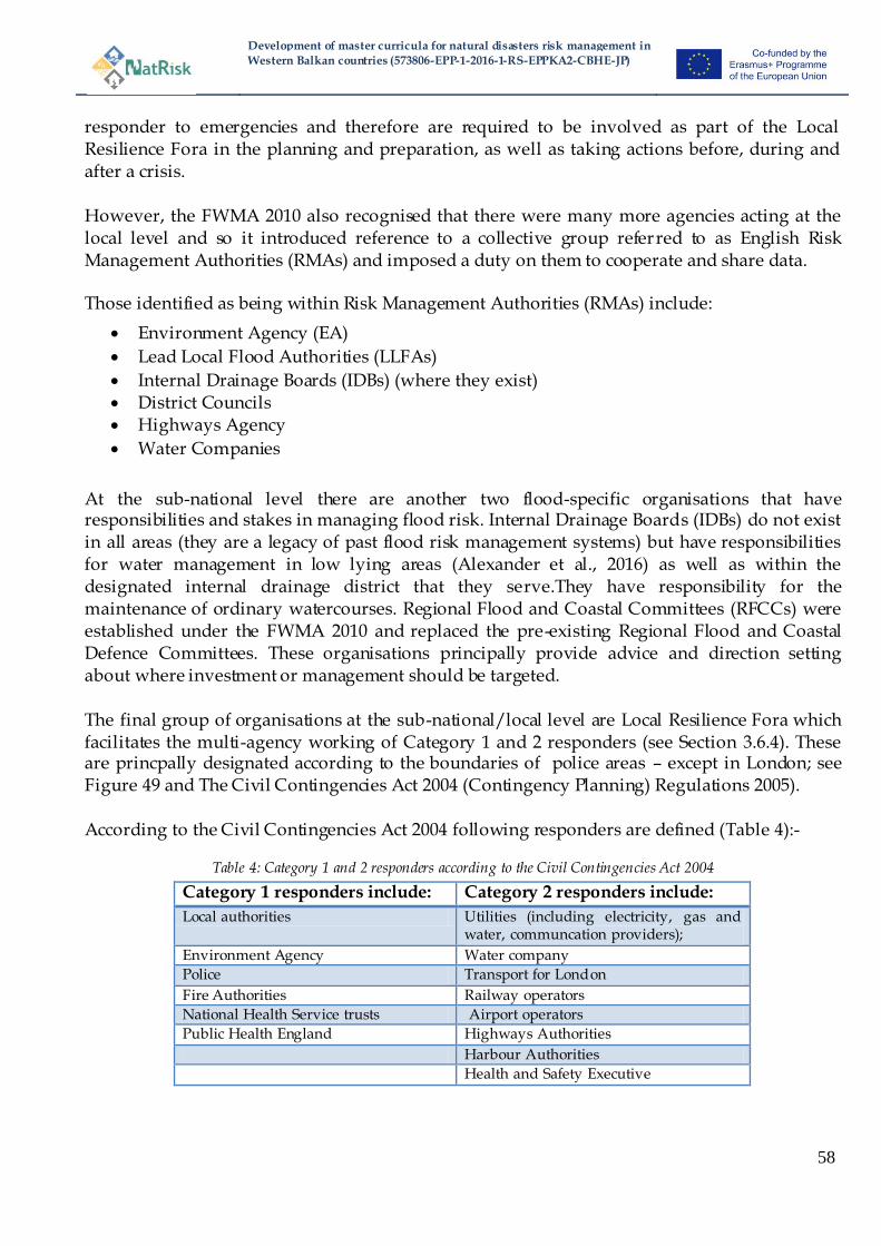
Development of master curricula for natural disasters risk management in
Western Balkan countries (573806-EPP-1-2016-1-RS-EPPKA2-CBHE-JP)
58
responder to emergencies and therefore are required to be involved as part of the Local Resilience Fora in the planning and preparation, as well as taking actions before, during and after a crisis. However, the FWMA 2010 also recognised that there were many more agencies acting at the local level and so it introduced reference to a collective group referred to as English Risk Management Authorities (RMAs) and imposed a duty on them to cooperate and share data. Those identified as being within Risk Management Authorities (RMAs) include:
Environment Agency (EA)
Lead Local Flood Authorities (LLFAs)
Internal Drainage Boards (IDBs) (where they exist) District Councils Highways Agency
Water Companies
At the sub-national level there are another two flood-specific organisations that have responsibilities and stakes in managing flood risk. Internal Drainage Boards (IDBs) do not exist in all areas (they are a legacy of past flood risk management systems) but have responsibilities for water management in low lying areas (Alexander et al., 2016) as well as within the designated internal drainage district that they serve.They have responsibility for the maintenance of ordinary watercourses. Regional Flood and Coastal Committees (RFCCs) were established under the FWMA 2010 and replaced the pre-existing Regional Flood and Coastal Defence Committees. These organisations principally provide advice and direction setting about where investment or management should be targeted. The final group of organisations at the sub-national/local level are Local Resilience Fora which facilitates the multi-agency working of Category 1 and 2 responders (see Section 3.6.4). These are princpally designated according to the boundaries of police areas – except in London; see Figure 49 and The Civil Contingencies Act 2004 (Contingency Planning) Regulations 2005). According to the Civil Contingencies Act 2004 following responders are defined (Table 4):-
Table 4: Category 1 and 2 responders according to the Civil Contingencies Act 2004
Category 1 responders include: Category 2 responders include:
Local authorities Utilities (including electricity, gas and water, communcation providers);
Environment Agency Water company
Police Transport for London
Fire Authorities Railway operators
National Health Service trusts Airport operators
Public Health England Highways Authorities
Harbour Authorities
Health and Safety Executive
Development of master curricula for natural disasters risk management in
Western Balkan countries (573806-EPP-1-2016-1-RS-EPPKA2-CBHE-JP)
59
In the context of heatwaves, alongside the responsibilities of the Local Resilience Fora and the Category 1 and 2 responders, there are multi-agency Local Health Resilience Partnerships (LHRPs) which have been established for strategic planning purposes and to bring together local health sector organisations (e.g. NHS Trusts, Ambulance Trusts etc.) (PHE, 2015b). Furthermore, Health and Wellbeing Boards (which act as forums for commissioners across health, social care and public health providers) are also involved in the strategic planning and preparation for heatwaves and other health-related risks.
4.5.3 General public
Many responsibilities for managing natural risk remain with the general public and the individual affected. As introduced in Section 3.6the legal responsibility for managing flood risk rests with the land or property owner and there is not statutory duty on the government to manage flood risks (Environment Agency, 2013). However, the government and local authorities have adopted certain permissive powers and this has made the situation more confusing for individuals, many of whom are unaware that; firstly that they are at flood risk and; secondly, that ultimately they are responsible for managing it. This confusion has led to a disparity between responsibilities and expectations of flood risk management. Therefore, in recent years there has been a concerted effort to try to inform and encourage local communities (in particular those living in unprotected areas and where residual risk is quite high) about their risk and enhance resilience. Pilot schemes (e.g. Flood Resilience Community Pathfinder; Twigger-Ross et al., 2015) have examined and evaluated different ways to engage the community better in flood risk management.
4.5.4 Private market actors: Insurance companies and water companies
Private market insurance-based recovery is a key element of managing some natural risks (flood, windstorm) in England. From April 2016 a new flood insurance scheme, Flood RE, was initiated which is a private market initiative under the regulation and scrutiny of central government (Penning-Rowsell and Priest, 2015). The scheme has established a pool which has formalised existing cross-subsidies which caps premium insurance costs in high flood risk areas. The pool is funded via those insurance premiums from the properties entered and a levy on all domestic insurance policies and pays for any claims of those properties in high risk areas which are entered into the pool. The scheme is a transition arrangement for 25 years which aims to maintain the availability and affordability of flood insurance to high risk properties whilst hoping to encourage homeowners to reduce their risk. As such, the insurance industry acts as a buffer for flood risk management and in managing residual risk (Penning-Rowsell et al., 2014; Alexander et al., 2016). Water companies in England were privatised in the 1980s and therefore are classified as being a private market actor although they are heavily regulated by the government and have commercial restrictions. The nine water companies in England are designated RMAs under the FWMA 2010 and have responsibilities for manging the risks of flooding from water and foul and/or combined sewers systems which provide drainage to buildings and yards.
Development of master curricula for natural disasters risk management in
Western Balkan countries (573806-EPP-1-2016-1-RS-EPPKA2-CBHE-JP)
60
4.5.5 Media
The broadcast media have an important role to play during natural events through the warning and dissemination of information to both professional partners and, in particular, the public. These relationships to broadcast messages have been formalised through the establishment of contractual agreements (Alexander et al., 2016). However, in England the media are also recognised as potentially influencing management and decision-making following events. Often media criticism of floods has been both severe and wide-reaching and has fuelled the increased politicisation of events. Following recent past events, the media have been critical of the performance and lack of defences, planning decisions, management decisions (such as the failure to dredge) and the response to flooding; some criticisms have been justified and others less so. These reports have often been followed by principally politically-driven knee-jerk reactions to respond to these very public negative criticisms and either the offer of increased assistance or the implementation of new management measures, sometimes with little scientific basis or without financial justification, have resulted (Alexander et al., 2016).
4.5.6 Other organisations
Some organisations within England can have an influence on the management of natural risks, in particular flood risk and coastal erosion. Organisations of this nature tend to be those which own large amounts of land such as the National Trust (an organisation which aims to purchase land or buildings to protect cultural/natural heritage) which are able to have a say about how their land is managed or enable opportunities such as natural flood management to be exploited. Other organisations have a particular interest such as the RSPB (Royal Society for the Protection of Birds) which again lobbies government for actions which promote (or do not harm) the conservation of birds and their habitats. Other interest groups and organisations, such as the National Farmers Union, also lobby government in order to represent their members‘ interests.
5 Assessment of risk management aspects
The objectives within this project include an assessment of the existing risk management in the participating EU countries. Advantages and disadvantages of the used strategies are outlined and any knowledge gaps are pointed out.
5.1 Austria
5.1.1 Advantages
Integrated natural hazard management
The integrated approach of risk management including coping, rebuilding and prevention measures offers several benefits for Austrian inhabitants. This approach provides comprehensive services for parties concerned including affected persons, companies and municipalities. The compliance with the risk circle ensures a sustainable treatment of natural disasters.
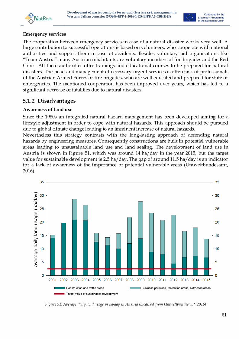
Development of master curricula for natural disasters risk management in
Western Balkan countries (573806-EPP-1-2016-1-RS-EPPKA2-CBHE-JP)
61
Emergency services
The cooperation between emergency services in case of a natural disaster works very well. A large contribution to successful operations is based on volunteers, who cooperate with national authorities and support them in case of accidents. Besides voluntary aid organisations like ―Team Austria‖ many Austrian inhabitants are voluntary members of fire brigades and the Red Cross. All these authorities offer trainings and educational courses to be prepared for natural disasters. The head and management of necessary urgent services is often task of professionals of the Austrian Armed Forces or fire brigades, who are well educated and prepared for state of emergencies. The mentioned cooperation has been improved over years, which has led to a significant decrease of fatalities due to natural disasters.
5.1.2 Disadvantages
Awareness of land use
Since the 1980s an integrated natural hazard management has been developed aiming for a lifestyle adjustment in order to cope with natural hazards. This approach should be pursued due to global climate change leading to an imminent increase of natural hazards. Nevertheless this strategy contrasts with the long-lasting approach of defending natural hazards by engineering measures. Consequently constructions are built in potential vulnerable areas leading to unsustainable land use and land sealing. The development of land use in Austria is shown in Figure 51, which was around 14 ha/day in the year 2015, but the target value for sustainable development is 2.5 ha/day. The gap of around 11.5 ha/day is an indicator for a lack of awareness of the importance of potential vulnerable areas (Umweltbundesamt, 2016).
Figure 51: Average daily land usage in ha/day in Austria (modified from Umweltbundesamt, 2016)
Development of master curricula for natural disasters risk management in
Western Balkan countries (573806-EPP-1-2016-1-RS-EPPKA2-CBHE-JP)
62
Organizational structure of natural hazards management
The federal administration focuses on prevention measures in risk management, which are different depending on the natural hazards. Due to this fact different administrations are responsible employing specialists of various scientific areas. The federal organization ―WLV‖ (Austrian Federal Torrent and Avalanche Control) focuses on natural hazards in alpine regions including mass movements, debris flows, rock falls, etc. and the federal organization ―BWV‖ (Austrian Federal Water Engineering Administration) deals with risk management in large rivers. However, the discrepancy is evident in successive or overlapping areas. The influence of tributaries on large rivers is important and therefore preventive measures have to be coordinated and information in case of emergency has to be distributed among the mentioned organizations. Similar issues are discernible between federal and provincial administrations as well as between different provincial administrations. The Austrian national territory is subdivided in nine different provinces leading to nine administrations and their corresponding legal bases. The various lawsparticularly affect spatial planning issues (controlled by federal administrations) resulting in different regulations in case of vulnerable areas. An improved cooperation between the different authorities as well as a standardization of legal bases is therefore desirable.
5.1.3 Knowledge gaps
Scientific research
Data acquisition has a long tradition in Austria and forms a solid base for scientific research. Nevertheless an expansion of gauges related to different research areas (e.g. permafrost, sediment transport, etc.) might close the existing knowledge gaps and improve the physical process understandings. Based on the new findings the existing risk management strategies might be improved to be prepared for future challenges like climate change.
Public awareness
In the Austrian general population there exists often a lack of understanding of natural hazards and their impacts due to the existing prevention measures. Only a small percentageis aware of residual risks and the need of individual responsibility. In the scope of information and participation events the public awareness should be increased to be better prepared in case of natural disasters.
5.2 Greece
5.3 Hungary
5.3.1 Advantages
Improved organization
In Hungary, both the constitutional and legislative environments for disaster management are new, implemented from 2012. There have been important changes in DM, especially concerning organization and responsibilities. The formulation of the DM Law was partially a result of experience with financial deficits during earlier disasters, and investigations on disasters and on the DM sector as a whole.

Development of master curricula for natural disasters risk management in
Western Balkan countries (573806-EPP-1-2016-1-RS-EPPKA2-CBHE-JP)
63
Just to give some examples: investigations after the severe thunderstorm in 2006 and floods in 2009-2010 pointed to the necessity of clear responsibility lines, education and emergency exercises, improvement of coordination among the stakeholders during disaster recovery, clear supervisory roles, and the importance of local disaster management planning. The red sludge disaster showed discrepancies of improper task division in supervising low and high threshold Seveso companies, procedures of issuing building permits, and dangers of improper implementation of EU requirements into the national legislative system. The DM system has become more centralized; responsibility lines and supervision are clearer at all levels of disaster management. At the local level, risk assessment, and for the high risk settlements, obligatory DM plans have been introduced. At the same time, mayors get help in coordinating and organizing DM tasks. There have been organizational changes concerning water management and municipal firefighters. The NDGDM coordinates other bodies during disaster response and holds a supervisory position.Special importance is given to education andsettlement-basedcivilprotection duties. In the new curricula of education there are elements of crisis management at all levels. From 2012, civil protection duties of the inhabitants have become more defined.
Clarification of responsibilities
The newcrisismanagementsystemintroducedinHungaryin2012 clarified the supervision over related institutions in disaster management and in industrial supervision. As the disaster management system has many supervising institutions, in case of a disaster there is a leading – supervising institution. In such a way the appropriate response as well as a clear responsibility line is kept. This is of special importance in the case of supervision of industrial objects – obtaining permissions from several institutions (environmental, mining directorates, local authorities, etc.) in order to avoid discrepancies (like in the case of the red sludge disaster) it is important to have one authority for supervising.
New position of the disaster management referee
An importantelementof thenew crisis(disaster) management system has been institutionalizing the help to politicians to fulfil crisis management related tasks and decision making. From 2012, a new position of the disaster management referee is established. They are employees of local governments, trained for helping the mayors in crisis management tasks. Their duties include: cooperating with crisis management authorities, preparing risk assessment plans and disaster prevention plans. They are trained by the Education Center for Disaster Management. The reasons for establishing the position of referee was related to the cases when mayors did not have qualifications for disaster response. During an emergency state the mayors‘ executive responsibility is overtaken by the directors of crisis management of the local authorities. In this way it is ensured that the response can be done by professional experts, timely and accurately.
Reference point for other countries
AsHungaryisanEUmember,legislativeandorganizationalelementsofEUcivilprotectionare implemented in the national legislation. The experience of this particular country in reforming the DM system can be a useful reference point for other countries facing reforms in the future.
5.3.2 Disadvantages
Initial problems of novel management
Development of master curricula for natural disasters risk management in
Western Balkan countries (573806-EPP-1-2016-1-RS-EPPKA2-CBHE-JP)
64
After implementing the new system, there probably are many things yet to be changed, and it will be revealed in reality if this system is more able to cope with crises than the previous ones.Potential bottlenecks of the system can be the result of novel elements like the newly introduced emergency call system, which requires time to get used to. Other potential difficulties can appear concerning the divided supervision of water management; water quality monitoring remains at the environmental authorities while flood protection is under the disaster management authorities. The system is not yet tested.
Shortage of finances for flood protection and disaster management
Another important consideration is a long-standing shortage of finances for flood protection and DM. This is difficult to change because of the present economic situation in Hungary. There has been a plan to implement a DM fee from industrial plants. However, partially due to legislative discrepancies, and the lobby against this from private enterprises, this part of the DM law has been withdrawn. At the same time, there is still no unified insurance system for high disaster risk areas. As a result, there remains an overall lack of finances in the sector.
5.3.3 Knowledge gaps
Awareness-raising and voluntarism
Inaddition toawareness-raising,theideaofinvolving inhabitantsthrough obligatorycivilprotection exercises and voluntarism is promising, and it might be a cost effective solution. Involving local people in disaster response is a good idea, since public acceptance of local help is higher than the ranking of official help from the central government. The future is evidently towards the involvement of private parties – outsourcing certain tasks and increasing the level of volunteering. There are examples of this at present in Hungary. However in the new system there is still a lot to be done in these fields.
5.4 Italy
Approach of coastal erosion management
In the 80s and 90s the problem was solved building hard structures like breakwaters, groins and seawall which protected the areas immediately behind, but moved the process downdrift. Starting from 2000 some intervention of nourishment has been realized, but until now there is not a clear awareness about the need of monitoring and management this intervention, the builded beach will be stable for few months/years. According with EUROSION (2004), a more strategic and proactive approach to coastal erosion is needed for the sustainable development of vulnerable coastal zones and the conservation of coastal biodiversity. In light of climate change it is recommended that coastal resilience is enhanced by: (a) restoring the sediment balance; (b) allocating space necessary to accommodate natural erosion and coastal sediment processes and (c) the designation of strategic sediment reservoirs.

Development of master curricula for natural disasters risk management in
Western Balkan countries (573806-EPP-1-2016-1-RS-EPPKA2-CBHE-JP)
65
5.5 England
Alexander et al. (2016) in their analysis of the governance of English Flood risk management highlighted a number of key strengths and weaknesses of the system. Many of these are pertinent to this discussion and are summarised and presented below.
5.5.1 Advantages
Long-established, integrated and diverse approach to management
Flood risk management in England has evolved in a piecemeal and flexible way which means that it is well-placed to respond quickly to emerging challenges. The diverse approach to management can also be regarded as a strength as it adopts a more proportional and efficient approach to managing flooding.
Balance between national and local management
The approach presented in England aims to balance the guidance and steer from national government, whilst maintaining the responsibilities at the local and individual level. lexander et al. (2016) highlighted the strong policy steer provided by national governments on a range of issues and a dedicated budget for investing in flood risk management measures. However, retaining legal responsibility with the land/property owner, the inception of Partnership Funding (Defra, 2012) which requires more local, as well as efforts to engage local stakeholders in flood risk management decision-making is reinforcing the message that responsibility and action rests with all those at risk. Public participation and awareness raising efforts are also recognised as key strengths (Alexander et al., 2016).
Private market recovery
The long-standing availability and penetration of insurance in England is a strength of the system and provides a key buffer to losses. The approach facilitates the diverse approach to risk management that has been adopted and means that a protectionist approach does not dominate.
Flood Forecasting and warning capabilities
Flood forecasting and warning are recognised strength of the English system. There is a clear framework for responsibilities for flood forecasting, warning and action exists which provides the best chance for effective action, in particular by professional responders and an established culture of multi-agency working and decision making.
5.5.2 Disadvantages
Funding
Although the push towards local level funding is beneficial and a recognised advantage of the English approach, it is debatable the extent to which these funds are bringing in new sources of funding. Many of the initial examples highlighted that the majority of the local funding was still coming from public finances that was being merely redistributed at the local level (Alexander et al., 2016). Furthermore, there were some concerns that Partnership Funding would interfere with the transparency and legitimacy of the process and allow some organisations to ‗jump the funding queue‘ (Thaler and Priest, 2014). A further criticism of Alexander et al. (2016) relates to whether sufficient funding will be made available for flood asset maintenance. Concern is also

Development of master curricula for natural disasters risk management in
Western Balkan countries (573806-EPP-1-2016-1-RS-EPPKA2-CBHE-JP)
66
raised about whether there is sufficient funding for Local Authorities to successfully fulfil their role as LLFAs as well as undertaking their responsibilities in planning and crisis planning and response. Government reductions in funding have seen the budgets of Local Authorities reduce in recent years which are placing pressure on all services that they provide including flood risk and crisis management (CCC, 2014).
Enforcement of planning conditions and encroachment of new development on the floodplain
The policy for spatial planning is in England is well-regarded and it is thought that large-scale inappropriate development in high risk areas is being prevented. However, there is concern that smaller developments or redevelopments are being permitted to encroach into floodplain areas and as such increasing the risk in those locations (CCC, 2014). Furthermore, there is a lack of enforcement of conditions placed on planning applications and therefore the true extent of any increase of inappropriate development in flood risk is unknown.
Managing SWF and sustainable urban drainage
Alexander et al. (2016) report a lack of progress in promoting sustainable urban drainage systems (SUDs) and ensuring their effectiveness. Provisions to strengthen the legal and policy framework in this area was included within the FWMA 2010, however opposition from developers (and others) meant that these provisions were not able to be implemented. The promotion of SUDs is still prominent within the spatial planning system and is required to be considered during (re)development, however it is not really clear i f this is resulting in better urban drainage outcomes.
6 Analysis of EU master curricula
The risk management of natural disasters requires well-developed professionals with appropriate knowledge. It is the responsibility of national institutions including universities to educate the mentioned specialists. In a few European member states special master curricula dealing with natural disaster risk management have been established. Other member states in turn have included appropriate courses in existing master curricula. Lists of relevant master programmesare outlined for each EU project partner country. Further details on the master programmes are provided in an additional report specialized on master curricula.
6.1 Austria
In Austria a few master‘s degree programmes related to natural disaster risk management are available at different universities (Table 5).
Table 5: Relevant master´s programmes in Austria
Master´s programme Academic degree
University
Alpine Natural Dangers /
Watershed Regulation
MSc University of Natural Resources and Life
Sciences, Vienna
Civil Engineering and Water Management
MSc University of Natural Resources and Life Sciences, Vienna
Geotechnical and Hydraulic MSc Graz University of Technology
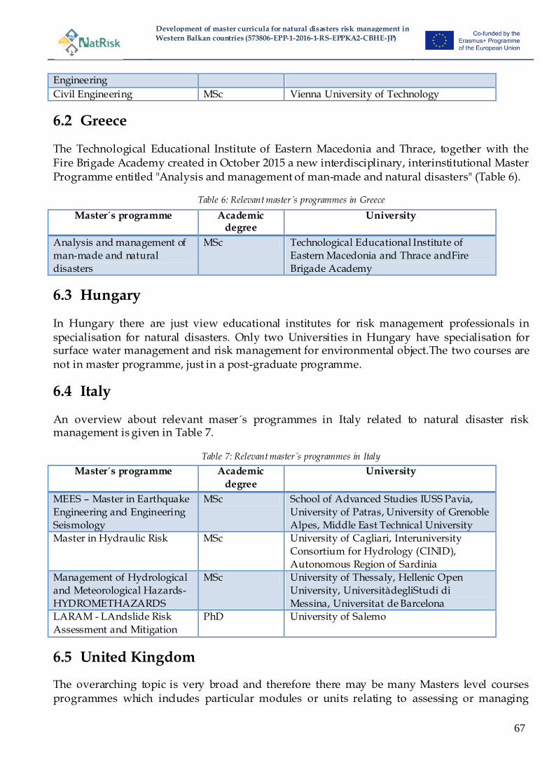
Development of master curricula for natural disasters risk management in
Western Balkan countries (573806-EPP-1-2016-1-RS-EPPKA2-CBHE-JP)
67
Engineering
Civil Engineering MSc Vienna University of Technology
6.2 Greece
The Technological Educational Institute of Eastern Macedonia and Thrace, together with the Fire Brigade Academy created in October 2015 a new interdisciplinary, interinstitutional Master Programme entitled "Analysis and management of man-made and natural disasters" (Table 6).
Table 6: Relevant master´s programmes in Greece
Master´s programme Academic degree
University
Analysis and management of
man-made and natural
disasters
MSc Technological Educational Institute of
Eastern Macedonia and Thrace andFire
Brigade Academy
6.3 Hungary
In Hungary there are just view educational institutes for risk management professionals in specialisation for natural disasters. Only two Universities in Hungary have specialisation for surface water management and risk management for environmental object.The two courses are not in master programme, just in a post-graduate programme.
6.4 Italy
An overview about relevant maser´s programmes in Italy related to natural disaster risk management is given in Table 7.
Table 7: Relevant master´s programmes in Italy
Master´s programme Academic
degree
University
MEES – Master in Earthquake
Engineering and Engineering
Seismology
MSc School of Advanced Studies IUSS Pavia,
University of Patras, University of Grenoble
Alpes, Middle East Technical University
Master in Hydraulic Risk MSc University of Cagliari, Interuniversity
Consortium for Hydrology (CINID),
Autonomous Region of Sardinia
Management of Hydrological
and Meteorological Hazards-
HYDROMETHAZARDS
MSc University of Thessaly, Hellenic Open
University, UniversitàdegliStudi di
Messina, Universitat de Barcelona
LARAM - LAndslide Risk
Assessment and Mitigation
PhD University of Salemo
6.5 United Kingdom
The overarching topic is very broad and therefore there may be many Masters level courses programmes which includes particular modules or units relating to assessing or managing

Development of master curricula for natural disasters risk management in
Western Balkan countries (573806-EPP-1-2016-1-RS-EPPKA2-CBHE-JP)
68
natural risks. However, the analysis presented for the UK herein only focusses on those Masters Programmes which predominantly focus on natural disasters and/or their management (Table 8).
Table 8: Relevant master´s programmes in the United Kingdom
Master´s programme Academic degree
University
Disasters, adaptation and development
MA/MSc Kings College London
Risk and Disaster Science MSc Institute for Risk and Disaster Reduction,
University College London
Risk and Disaster Resilience MSc Institute for Risk and Disaster Reduction,
University College London
Risk and Disaster Reduction MSc Institute for Risk and Disaster Reduction, University College London
Disaster Management and
Sustainable Development
MSc Northumbria University
MA/MSc in Risk MA/MSc Durham University
Crisis and disaster
management
MSc University of Portsmouth
Disaster Management MSc Coventry University
Emergency Planning and
Management
MSc Coventry University
Risk Disaster and
Environmental Management
MSc University of Huddersfield
International Disaster Management
MSc University of Manchester
Disaster Resilience and
Management
MRes University of Salford
Disaster Management for
Environmental Hazards
MSc University of South Wales
Crisis and Disaster Management
MSc University of Lincoln
Risk, Crisis and Disaster
Management
MSc University of Leicester
7 Literature
Alexander, M., S. Priest, A.P. Micou, S. Tapsell, C. Green, D. Parker, and S. Homewood.(2016). Analyzing and evaluating flood risk governance in England – Enhancing societal resilience through comprehensive and aligned flood risk governance.STAR-FLOOD Consortium. Flood Hazard Research Centre, Middlesex University. Available online http://www.starflood.eu/documents/2016/03/wp3-en-final-webversion.pdf
Association of British Insurers (ABI) (2014). UK Insurance and Long-Term Savings; Key Facts, ABI: London. Available online: https://www.abi.org.uk/~/media/Files/Documents/Publications/Public/2016/KeyFacts/ABI-UKInsuranceAndLongTermSavings-KeyFacts.pdf
Development of master curricula for natural disasters risk management in
Western Balkan countries (573806-EPP-1-2016-1-RS-EPPKA2-CBHE-JP)
69
Association of British Insurers (ABI) (2016). 2015/16 floods: the story so far, https://www.abi.org.uk/Insurance-and-savings/Topics-and-issues/Flooding/Flooding-in-numbers
Baxter, P.J. (2005) The east coast Big Flood, 31 January–1 February 1953: a summary of the human disaster, Philosophical Transactions of the Royal Society A: Mathematical, Physical and Engineering Sciences, 363 (1831) 1293-312.
BMLFUW – Bundesministerium für Land- und Forstwirtschaft, Umwelt und Wasserwirtschaft (2006a). Hochwasser 2005 – Ereignisdokumentation, Teilbericht des Hydrographischen Dienstes, Vienna.
BMLFUW – Bundesministerium für Land- und Forstwirtschaft, Umwelt und Wasserwirtschaft (2006b). Hochwasser 2005 – Ereignisdokumentation der Bundeswasserbauverwaltung, des Forsttechnischen Dienstes für Wildbach- und Lawinenverbauung und des Hydrographischen Dienstes, Vienna.
BMLFUW – Habersack, H., Pucher, K., Schober, B., Samek, R. (2015).Hochwasser Juni 2013 Ereignisdokumentation. In: Bundesministerium für Land- und Forstwirtschaft, Umwelt und Wasserwirtschaft (ed.). Wien.
BMLFUW – Bundesministerium für Land- und Forstwirtschaft, Umwelt und Wasserwirtschaft (2016).Nationaler Hochwasserrisikomanagementplan RMP 2015 GZ: BMLFUW-IL.99.1.1/0191-IV/2015, Vienna.
BMLFUW – Bundesministerium für Land- und Forstwirtschaft, Umwelt und Wasserwirtschaft (2017a). HORA - Natural hazard overview and risk assessment. www.hora.gv.at. Accessed in Jan 2017
BMLFUW – Bundesministerium für Land- und Forstwirtschaft, Umwelt und Wasserwirtschaft (2017b). Wasserinformationssystem Austria.http://wisa.bmlfuw.gv.at/. Accessed in Jan 2017
Cabinet Office (2015) National Risk Register of Civil Emergencies, 2015 edition, Cabinet Office, London.
Chatterton, J., Clarke, C., Daly, E., Dawks, S., Elding, C., Fenn, T., Hick, E., Miller, J., Morris, J., Ogunyoye, F. and Salado, R,. (2016) The costs and impacts of the winter 2013 to 2014 floods Report (SC140025/R1) Environment Agency, Bristol, UK.
Chatterton, J., Viavattene, C., Morris, J., Penning-Rowsell, E. and Tapsell, S. (2010) The costs of the summer 2007 floods in England (Project: SC070039/R1), Environment Agency, Bristol, UK.
Civil Contingencies Act 2004.Chapter 36.HMSO:London. Committee on Climate Change (CCC) (2012) Climate Change: is the UK preparing for flooding
and water scarcity? Adaptation Sub-Committee, CCC: London Committee on Climate Change (CCC) (2014) Managing climate risks to well-being and the
economy, Adaptation Sub-Committee Progress Report 2014, CCC: London https://www.theccc.org.uk/wp-content/uploads/2014/07/Final_ASC-2014_web-version-4.pdf
Committee on Climate Change (CCC) (2017) UK Climate Change Risk Assessment 2017 Evidence Report: Key messages from the Synthesis Report www.theccc.org.uk/uk-climate-change-risk-assessment-2017
Cowen , L. and Mallinson, J. (2005) Carlisle storm and flood January 2005, recovery phase debrief report, Carlisle City Council and Cumbria Country Council,

Development of master curricula for natural disasters risk management in
Western Balkan countries (573806-EPP-1-2016-1-RS-EPPKA2-CBHE-JP)
70
https://www.gov.uk/government/uploads/system/uploads/attachment_data/file/78990/carlisle-recovery-phase-debrief-report.pdf
CRED – Centre for Research on the Epidemology of Disasters (2009). EM-DAT: The OFDA/CRED International Disaster Database. www.emdat.be. Accessed in Feb 2017.UniversitéCatholique de Louvain – Brussels – Belgium.
Cumbria Resilience (2011) Cumbria floods November 2009 learning from experience recovery phase debrief report, http://www.cumbria.gov.uk/eLibrary/Content/Internet/533/561/4066711109.pdf
Department for Communities and Local Government (DCLG) (2012) National Planning Policy Framework. DCLG; London
Department for Communities and Local Government (DCLG) (2013) The Bellwin Scheme of Emergency Financial Assistance to Local Authorities: Guidance notes for claims 2013, DCLG: London.
Department for Communities and Local Government (DCLG) (2014) Winter 2013/14 severe weather recovery progress report - An overview of the Government‘s recovery support November 2014, DCLG, London.
Department, Flood and Rural Affairs (Defra) (2008) The Government‘s Response to Sir Michael Pitt‘s Review of the Summer 2007 Floods, Defra, UK. Online at https://www.gov.uk/government/uploads/system/uploads/attachment_data/file/194675/govtresptopitt2008.pdf.
Department, Flood and Rural Affairs (Defra) (2009) The Government‟ s Response to Sir Michael Pitt‘s Review of the summer 2007 Floods Progress Report Defra, UK.Online https://www.gov.uk/government/uploads/system/uploads/attachment_data/file/69426/pb13565-pitt-progress-091215.pdf.
Department for Environment, Food and Rural Affairs (Defra)(2011) Detailed guidance on Developing a multi-agency flood plan. June 2011. Available from https://www.gov.uk/government/uploads/system/uploads/attachment_data/file/254294/pb14046-develop-multi-agency-flood-plan.pdf
Department for Environment, Food and Rural Affairs (Defra) (2012) Principles for implementing flood and coastal resilience funding partnerships.Defra; London. Available online: http://a0768b4a8a31e106d8b0-50dc802554eb38a24458b98ff72d550b.r19.cf3.rackcdn.com/LIT_6696_f143f7.pdf
Department, Flood and Rural Affairs (Defra) (2012) The Government‘s Response to Sir Michael Pitt‘s Review of the summer 2007 Floods Final Progress Report, 27 January 2012, Defra, UK. Online at https://www.gov.uk/government/uploads/system/uploads/attachment_data/file/69489/2012-01-31-pb13705-pitt-review-progress.pdf
Department, Flood and Rural Affairs (Defra) (2014) The National Flood Emergency Framework for England, December 2014, Defra: London, UK.
Environment Agency (2009a) Flooding in England: A National Assessment. Environment Agency: Bristol, UK.
Environment Agency (2009b) Investing in the Future: Flood and Coastal Risk Management in England. A long term investment strategy. Environment Agency: Bristol.
Environment Agency (2012) Flood plan guidance for communities and groups – practical advice to help you create a flood plan, Environment Agency: Bristol. Online at
Development of master curricula for natural disasters risk management in
Western Balkan countries (573806-EPP-1-2016-1-RS-EPPKA2-CBHE-JP)
71
https://www.gov.uk/government/publications/flood-plan-guidance-for-communities-and-groups
Environment Agency (2013) Living on the Edge. A guide to your rights and responsibilities of riverside ownership. Environment Agency: Bristol.
Environment Agency (2016) Reducing flood risk from source to sea: First steps toward an integrated catchment plan for Cumbria, Environment Agency: Bristol, UK.
Environment, Food and Rural Affairs Committee (EFRA) (2016) Future flood prevention.Published 2nd November 2016 by authority of the House of Commons. London, UK.
EU-Directive (2000/60/EG).Directive for establishing a framework for Community action in the field of water policy (water framework direction).European Parliament and Council , Official Journal of the European Union, L 327/1-73.
EU Directive (2007/60/EC). Directive on the assessment and management of flood risks.European Parliament and Council, Official Journal of the European Union, L 288/27-34.
EUROSION. 2004. Living with coastal erosion in Europe: Sediment and Space for Sustainability. A guide to coastal erosion management practices in Europe.
Evans, E., Ashley, R., Hall, J., Penning-Rowsell, E., Sayers, P., Thorne, C. and Watkinson, A. (2004) Foresight future flooding: Scientific Summary II Managing Future Flood Risks. Office of Science and Technology: London
Evans, E.P., Simm, J.D., Thorne, C.R., Arnell, N.W., Ashley, R.M., Hess, T.M., Lane, S.N., Morris, J., Nicholls, R.J., Penning-Rowsell, E.C., Reynard, N.S., Saul, A.J., Tapsell, S.M., Watkinson, A.R., Wheater, H.S. (2008) An update of the Foresight Future Flooding 2004 qualitative risk analysis. Cabinet Office; London
Fierro, G. &Ivaldi, R., 2001. The Atlas of the Italian Beaches: a review of coastal processes, (E. Özhan, Ed.), Proc. of the Fifth International Conference on the Mediterranean Coastal Environment, MEDCOAST 01, MEDCOAST Secretariat, Middle East Technical University, Ankara, Turkey, v: 3, pp: 1557-1566.
Flood and Water Management Act 2010.Chapter 29. The Stationery Office: London Flood Risk Regulations 2009. No.3042. The Stationery Office: London. Habersack H, Bürgel J, Petraschek A (2004).Analyse der Hochwasserereignisse vom August
2002—FloodRisk Synthesebericht. Bundesministeriumfür Land- und Forstwirtschaft, Umwelt und Wasserwirtschaft, Vienna.
HM Government (2012) Emergency response and recovery: Non statutory guidance accompanying the Civil Contingencies Act 2004.Cabinet Office 2012.
HM Government (2016) National Flood Resilience Review, September 2016, HM Government, UK Crown Copyright.
Interpraevent - Internationale Forschungsgesellschaft (2009). Alpine Naturkatastrophen Lawinen Muren Felsstürze Hochwässer. Leopold Stocker Verlag GmbH, Graz.
Land Drainage Act 1991,Chapter 59, HMSO: London. Marsh, T., Kirby, C., Muchan, K., Barker, L., Henderson, E. and Hannaford, J. (2016) The winter
floods of 2015/2016 in the UK - a review, National Hydrological Monitoring Programme, Centre for Ecology and Hydrology, Wallingford, UK.
National Audit Office (2014) Strategic flood risk management, Report by the Comptroller and Auditor General, HC 780 Session 2014-15 5 November 2014, National Audit Office, London, UK.
Development of master curricula for natural disasters risk management in
Western Balkan countries (573806-EPP-1-2016-1-RS-EPPKA2-CBHE-JP)
72
OVF - OrszágosVízügyiFőigazgatóság [General Directorate of Water Management] (2017).VízügyHonlap [Website of the Watermanagement].www.vizugy.hu. Accessed in Mar 2017.
Penning-Rowsell, E.C and Priest, S.J. (2015) Sharing the burden: who pays for flood insurance and flood risk management in the UK, Mitigation and Adaptation Strategies to Global Change, 20(6), pp 991-1009.
Penning-Rowsell, E.C., Priest, S.J. and Johnson, C.J. (2014) The evolution of UK flood insurance: Incremental change over six decades, International Journal of Water Resources Development, 30 (4), 694-713.
Pitt, M. (2008) Learning lessons from the 2007 floods. The Pitt Review, Cabinet Office: London Priest, S.J., Clark, M.J. and Colclough, S. (2008) Public awareness of flood risk: The Role of the
Environment Agency Flood Map - Nominated report submitted to the ESRC, June 2008. Priestley, S. (2016) Winter floods 2015-16, Briefing Paper No. CBP7427, 21 January 2016, House
of Commons Library, London, UK. Public Health England (PHE) (2015a) Heatwave plan for England – Making the case: the impact
of heat on health – now and in the future, Public Health England: London, UK. Public Health England (PHE) (2015b) Heatwave plan for England – Protecting health and
reducing harm from severe heat and heatwaves, Public Health England: London, UK. Reservoirs Act 1975, Chapter 23, HMSO: London. Thaler, T. and Priest, S.J. (2014) Partnership funding in flood risk management: new localism
debate and policy in England, Area, 46(4), 418-425. Rudolf-Miklau F, (2009). Naturgefahren-Management in Österreich. LexisNexis Verlag ARD
Orac GmbH & Co KG, Vienna. The Civil Contingencies Act 2004 (Contingency Planning) Regulations 2005.Statutory
Instruments.No. 2042. HMSO: London. The Water Environment (Floods Directive) Regulations (Northern Ireland) 2009, Statutory rules
of Northern Ireland 2009 No. 376, The Stationery Office: London. http://www.legislation.gov.uk/nisr/2009/376/pdfs/nisr_20090376_en.pdf
Town and Country Planning Act 1990, Chapter 8, The Stationery Office: London. Twigger-Ross, C., Orr, P., Brooks, K., Sadauskis, R., Deeming, H., Fielding, J., Harries, T.,
Johnston, R., Kashefi, McCarthy, S., Rees, Y and Tapsell, S. (2015) Flood Resilience Community Pathfinder Evaluation, Final report FD1664, Defra: London.
UK Government (2016). Winter 2015 to 2016 floods: government response. https://www.gov.uk/government/news/north-west-england-floods-2015-government-response. Accessed in Jan 2016.
Umweltbundesamt (2016).ElfterUmweltkontrollbericht. Umweltsituation in Österreich.Umweltbundesamt, Vienna.