Embed Size (px)
Citation preview

November 2020 |
Report of the Manning River Taskforce Investigating options to improve safety and navigability of the Manning River entrance

Report of the Manning River Taskforce November 2020 2
Contents 1. Executive Summary ................................................................................................ 4
Introduction to the Taskforce ............................................................................... 4 Purpose of this report .......................................................................................... 4
2. The Manning River Entrance – realising a long overdue opportunity ..................... 6
3. The Manning Valley – a vibrant regional destination .............................................. 8 The Manning Valley ............................................................................................ 8 Economic benefits for the Manning Valley .......................................................... 9
Tourism and the visitor economy ............................................................... 9 Agriculture and Aquaculture ..................................................................... 10
Existing river entrance conditions ..................................................................... 11 Over 100 years of “thinking” .............................................................................. 12
4. Supporting NSW Government Ambitions for Regional NSW ............................... 13 Policy context .................................................................................................... 13
Maritime Infrastructure Plan ..................................................................... 13 Coastal Management Program(s) ............................................................ 13
Using improved river access to drive economic opportunity ............................. 14
5. Alignment with NSW Government policy and objectives ...................................... 15
6. Scope to take forward ........................................................................................... 17 Options to address navigability and safety of the Manning River Entrance ...... 17 Base case – Status quo/Do nothing .................................................................. 17 Do minimum- Routine dredging scheme ........................................................... 17 Southern entrance breakwater option ............................................................... 19 Manning Point twin breakwaters ....................................................................... 21 Supporting activity ............................................................................................. 23
7. Taskforce Recommendations ............................................................................... 24 Attachment 1 – Manning River Taskforce Terms of Reference ........................ 25 Attachment 2 – Reference reports .................................................................... 28 Attachment 3 – Strategic Business Case – scope and governance ................. 29

Report of the Manning River Taskforce November 2020 3
Report of the Manning River Taskforce November 2020 4
1. Executive Summary Introduction to the Taskforce
In March 2020, the Minister for Transport and Roads, together with the Member for Myall Lakes, announced the establishment of the Manning River Taskforce to review options for providing a permanent entrance to the Manning River1. The purpose of the Taskforce as described in the Terms of Reference (Attachment 1) was to consider the potential economic impacts, and review options, to improve the navigability of this complex and dynamic estuarine environment - within the context of the Coastal Management Act 2016 (the Act). The Taskforce has relied on the significant body of existing work, as well as updated and new analysis, to arrive at the recommendations contained within this report. The Taskforce was comprised of experts in coastal engineering, maritime infrastructure, coastal management and maritime industry, and was Chaired by NSW Maritime. To assist Government in its deliberations, the Taskforce has also considered local community sentiment, potential flow-on consequences of options, and the likely cost and timing of progressing this initiative to the next stage of analysis - the preparation of a Strategic Business Case (SBC), in accordance with the NSW Government’s Infrastructure Investment Assurance Framework.
Purpose of this report
This Report summarises the work undertaken by the Taskforce to identify the most viable options to take forward for further analysis, and to assist Government decision making in relation to the project.
Leveraging off community support and current focus on stimulating the economy in Regional NSW, the Taskforce has explored options to deliver a permanent entrance at the northern Harrington inlet, with a possible additional investment to similarly improve the accessibility of the southern reach of the Manning at Farquhar inlet.
Improving navigability may contribute to both NSW and Local Government objectives, including:
• Enabling job creation and opportunities for economic growth • Creating a positive business environment • Providing efficient and environmentally acceptable transport networks • Maintaining or enhancing natural environmental qualities • Providing adequate and appropriate open space • Providing community facilities in an equitable manner.
There are a variety of constraints and influences which will require significant investigation, with no single, simple, cost effective intervention immediately identifiable. Taskforce has identified 3 options to progress to more detailed consideration in an SBC. The SBC process provides an opportunity for a more detailed analysis of both the problem and potential solutions, including rigorous economic analysis.
1 Media Release 20 March 2020
Report of the Manning River Taskforce November 2020 5
Given that there is likely to be a significant investment cost in a permanent solution and a lengthy planning and approvals process, particularly in relation to the protection of endangered species and management of coastal industries (including oyster farms), detailed economic and financial analysis (as is normal in an SBC) should be undertaken to properly understand the full range of benefits that investment in the Manning River Entrance Project (MREP) is likely to yield. As required by its Terms of Reference, this Taskforce Report has had regard for the Act, in particular its relevant objects which are reproduced below (emphasis added as appropriate).
“ Section 3: Objects of this Act The objects of this Act are to manage the coastal environment of New South Wales in a manner consistent with the principles of ecologically sustainable development for the social, cultural and economic well-being of the people of the State, and in particular— (a) to protect and enhance natural coastal processes and coastal environmental values
including natural character, scenic value, biological diversity and ecosystem integrity and resilience, and
(b) to support the social and cultural values of the coastal zone and maintain public access, amenity, use and safety, and
(d) to recognise the coastal zone as a vital economic zone and to support sustainable coastal economies, and
(f) to mitigate current and future risks from coastal hazards, taking into account the effects of climate change, and
(g) to recognise that the local and regional scale effects of coastal processes, and the inherently ambulatory and dynamic nature of the shoreline, may result in the loss of coastal land to the sea (including estuaries and other arms of the sea), and to manage coastal use and development accordingly,
(i) to encourage and promote plans and strategies to improve the resilience of coastal assets to the impacts of an uncertain climate future including impacts of extreme storm events.”
Should Government determine that it is appropriate to progress to further stages of analysis, this will require consideration of all related NSW Government legislation, policies and strategies in place as part of a strategic alignment analysis within any Strategic Business Case.

Report of the Manning River Taskforce November 2020 6
2. The Manning River Entrance – realising a long overdue opportunity
The Manning River is a large river on the Mid North Coast of NSW which has two main inlets from the Pacific Ocean, one located at Harrington in the North and the other at Farquhar Inlet near Old Bar to the south. It is the only double delta river system in NSW with two entrances to the ocean2. This unique feature impacts available options for improving access to the River due to the interactions between the northern and southern inlets. The area hosts agricultural lands, commercial oyster farms, commercial fishing, and boating related industry. The Manning River is a significant drawcard for tourism and water sports.
Figure 1 The Manning River entrance, Harrington
The unstable state of the entrance to the Manning River is viewed by some members of the community as stifling both the economic and social growth of communities along the river. Over the course of several decades, Government has undertaken studies in attempt to clearly articulate the problems associated with the river inlet, and potential solutions. The major issues considered in previous studies are summarised as:
• Heavy shoaling at Harrington can make conditions treacherous for entry • Navigation through both Harrington and Farquhar inlet is unpredictable and heavily
influenced by tides • Detrimental effect to the local community and business caused by both shoaling and
erosion • Detrimental impacts on Harrington inlet when Farquhar inlet is open, and vice versa • Manning Point beach is vulnerable to both coastal erosion and marine and river
inundation • Spoil and sediment from dredging or activity to open Harrington may affect commercial
oyster leases • The impact of tidal flushing of the estuary.
2 Manning Valley Tourism, http://visitmanningvalley.com.au/activities/river/ accessed 09 September 20203 Taree-Great Lakes Regional Boating Plan

Report of the Manning River Taskforce November 2020 7
Several benefits may be delivered by improving the river entrance. These include:
• Stimulation of marine development • Improved safety for commercial and recreational vessels • Reduce risk of flooding and damage to infrastructure and property especially at
Manning Point • Increase in property values • Promotion of local boat industry • Increased opportunity for marina berth construction and operation • Growth in tourism.
These benefits (and potentially others yet to be identified) require thorough investigation and proper consideration through economic analysis for Government to clearly understand the net impacts of progressing any improvements to the river entrances.
Key message: Quantifiable economic benefit has not yet been extensively considered. This should be carefully analysed and fully quantified so that the true impacts of stabilising the entrance are understood.
Report of the Manning River Taskforce November 2020 8
3. The Manning Valley – a vibrant regional destination
The Manning River is the only double delta river system in Australia with two entrances to the ocean, and one of the few large waterways in NSW that has not been dammed for water supply purposes. The estuary is a very popular waterway for a diverse range of recreational activities, as well as being the home to a sizable oyster industry. Usage of the region’s waterways swell during the summer months, with approximately 250,000 tourists that visit the Manning Valley each year. This places pressure on existing infrastructure, and can increase safety risks. During peak times, conflicts occur between recreational and non-recreational users sharing the Manning River, and between power boaters and non-powered craft users There are approximately 15,000 boat licence holders in the Taree – Great Lakes region. This represents approximately 2.8% of all boating licences in NSW3. There are approximately 8,700 registered recreational vessels in the region. This represents approximately 3.7% of all registered recreational vessels in NSW. The most common vessel hull types in this region are open runabouts followed by punts and cabin runabouts. The vast majority of registered vessels are below 6 m and the average vessel length is 4.7 m. These statistics are of interest to provide context and scale, however, they do not capture vessels from other regions utilising the Manning, or potential opportunities missed due to variable access and navigation challenges.
The Manning Valley
The population of the Mid-Coast Council area, which covers the Manning Valley, is approximately 95,000 people. This is expected to grow by some 19% to 113,000 by 20364. The area’s contribution to the economy represents approximately $3.41 billion5. This has remained relatively stagnant since at least 2006. More specifically, the communities of Harrington, Manning Point and Old Bar are home to some 7,600 people, many of whom are either retired or employed in accommodation and hospitality industries. The dynamic estuary environment presents a risk to the homes and workplaces of these communities. Recent coastal events at Wamberal NSW6 demonstrate the extent of damage that can be caused by unchecked coastal erosion in developed areas. This event, triggered by a weather event known as an “East Coast Low”, resulted in significant damage to over 20 homes, and a further 44 homes rendered unsafe to inhabit for a period of time. In the ensuing weeks, government was forced to act to shore up the coastline and protect it from further damage, and form a Taskforce to determine a long-term solution for the beachfront. Given that Manning Point has long been identified as susceptible to similar catastrophic impacts should there be a significant flooding event, the Taskforce has taken into account the need to protect private and publicly held assets in considering its advice to government.7
3 Taree-Great Lakes Regional Boating Plan 4 Idcommunity demographic resources http://economy.id.com.au/midcoast accessed 15/09/20 5 Idcommunity demographic resources http://economy.id.com.au/midcoast accessed 15/09/20 July 2020 6 Coast Community News, “Wamberal Beach erosion prompts action” 7 Manly Hydraulics Laboratory, “Manning River’s Harrington Entrance Expert Workshop Summary Report”

Report of the Manning River Taskforce November 2020 9
Key message: Work to protect Manning Point from potential flood events are necessary and expedient
Economic benefits for the Manning Valley
Health care and social assistance is currently the largest employment sector in the area, employing approximately 18% of the working population, however the retail, accommodation, and food services sectors collectively employ some 23% of the working population8.
Tourism and the visitor economy
The visitor economy encompasses hospitality, retail, cultural programs and many activities that may affect a visitor’s travelling experience. In the Mid Coast local government area, tourism (including accommodation and food services) directly employs 25.1% of the local working population9. In the five years to 2016, the overall employment in the tourism and visitor economy sector decreased marginally (by 0.8%) as retail and associated employers failed to thrive. However, employment in Manning Valley, particularly in the areas of accommodation and food services (which grew by around 160 jobs between 2011 and 2016) is expected to grow in the wake of COVID 19, as domestic travel and “staycations” become more accessible than international travel for most Australians. Figure 2 Employment by sector in the Mid-Coast LGA
Natural assets are key to the region’s tourism strategy, particularly the coastline, Manning River, and seaside villages. Manning Valley River Cruises operates a scenic river cruise along the Manning between Wingham and Harrington, providing access and commentary on the
8 Idcommunity demographic resources http://economy.id.com.au/midcoast accessed 15/09/20 9 Reference to Visitor Economy Action Plan http: / / www.business.nsw.gov.au / doing-business-in-nsw / industry-action-plans / visitor-economy
Health care and social assistance
18%
Construction7%
Agriculture, forestry and
fishing6%
Tourism economy
Mining1%
Manufacturing6%
Other37%
EMPLOYMENT BY SECTOR - MID-COAST LGA

Report of the Manning River Taskforce November 2020 10
history of the area. There is a small boat shed at Manning Point, which provides boat hire and facilitates fishing/boating tourist activity. The entrance and challenging navigational environment of the Manning River is not dissimilar to that of the Richmond River. The Richmond River is located on the far north coast of NSW and has its entrance at the town of Ballina. The river is permanently open due to twin breakwaters that were constructed in the 1900s. The Richmond River experiences strong recreational use, along with commercial and tourism offerings, including sunset cruises and charter fishing tours which commence in Ballina, cross the bar and operate in the open fishing grounds. It is likely that with more predictable access and capability to navigate the entrance of the Manning, both recreational boaters and commercial operators would be similarly encouraged to make greater use of the waterway.
Key message: It is likely that local tourism and commercial opportunities will increase if the project proceeds.
Agriculture and Aquaculture
Agriculture is a significant industry in the Manning Valley, with the beef industry alone generating approximately $87.4 million per annum. The dairy industry produces a further $91.5 million. The health and viability of low lying grazing lands, in particular impacts from erosion and ability to drain land is of importance to local land holders. Aquaculture is also an important industry in NSW, valued at over $200m annually, and is integral to the economy of coastal regional NSW. The state is the largest producer of oysters in Australia10. In 2018/19 annual oyster production was 6.3 million dozen oysters, at a market value of approximately $54.8 million11. Of this, 125,673 dozen oysters were produced on the Manning, with a value of $1.1 million to the local economy. One of the key requirements for productive oyster growth is healthy environmental conditions. On the Manning River, in addition to the existing oyster leases, significant portions of both the northern and southern reaches have been identified by the Department of Primary Industries as priority oyster aquaculture areas (refer figures 3 and 4 below).
10 NSW Oyster Industry Sustainable Aquaculture Strategy 2016 11 Aquaculture Production report 2018-2019

Report of the Manning River Taskforce November 2020 11
Figure 3 Oyster farming, Manning River North
Figure 4 Oyster farming, Manning River South
The availability of fresh, locally produced oysters is a key tourism influencer, and regional tourism studies have found that 89% of visitors to regional and coastal areas expect to eat local seafood when they visit12.
Existing river entrance conditions
The Manning River entrance at Harrington is an open estuary which is influenced by catchment water flows, floodplain hydrological changes, dredging, entrance opening, and
12 Barclay, K., McIlgorm, A., Mazur, N., Voyer, M., Schnierer, S., and Payne A. December 2016 Social and Economic evaluation of NSW Coastal Aquaculture
Key message: The relationship between Farquhar Inlet and Harrington must be front of mind in planning so that agriculture and aquaculture are not adversely impacted.

Report of the Manning River Taskforce November 2020 12
climate change impacts. A single breakwater is in place to the north of the Harrington entrance, which is approximately 3km long (2km extending upstream; 1km seaward). The Farquhar Inlet to the south has no permanent entry and is naturally opened/closed at various times by sand movements. Management of the river estuary itself is subject to a range of management plans, including Mid Coast Council’s Manning River Estuary Management Plan and Draft Farquhar Inlet and Old Bar Opening Management Plan. The Farquhar Inlet Opening Strategy also deals with options to manage flood waters and water quality, which is necessary largely due to manage the water quality requirements imposed by the NSW Food Authority for oyster production. Mid Coast Council has indicated that the Manning River is highly valued by the local community, particularly for its aquatic ecosystem health, visual amenity, cultural and spiritual value.
Over 100 years of “thinking”
Addressing the lack of stability in the Manning River entrance at Harrington has been the subject of multiple studies and reports, starting with the original surveying activity in the mid-to-late 1800s. Over the past 35 years in particular there has been detailed consideration on multiple occasions, with very little progress on determining what may deliver the optimal outcome for the river and the region. This is partly because, while the implementation of a southern breakwater to fully train the Harrington inlet is by far the most frequently raised solution, each body of work appears to have focused on understanding the existing processes and drivers, as opposed to detailed investigation of the consequences, both positive and negative, of various types of interventions. While this is not uniformly the case, it is largely applicable to the vast majority of investigations to date. The taskforce has considered the significant previous work in its deliberations. A list of the reports reviewed can be found in Attachment 2. The large volume of high-quality technical work has added to the overall body of knowledge regarding how the coastal processes operate and resulting erosion/transport of sediment. However, in terms of considering the need for government intervention, full cost-benefit analysis and broader strategic reasons for improving the stability of the inlet, little value is added. As part of its work, the taskforce, has been careful to consider the management of the Manning River entrance from a broader range of perspectives and has come to its recommendations with these in mind.
Key message: In order to progress beyond informal “ideas”, it is necessary to complete a properly considered strategic business case.

Report of the Manning River Taskforce November 2020 13
4. Supporting NSW Government Ambitions for Regional NSW
Policy context
Maritime Infrastructure Plan
The key document guiding investment in maritime infrastructure in NSW is the Maritime Infrastructure Plan 2019-2024 (MIP). It was developed by Transport for NSW to guide evidence based decision making that will deliver the greatest benefits to recreational boaters, commercial fishers and the tourism industry. The MIP identifies 14 strategically significant locations across the state as priorities for investment. The Manning River is not identified as one of these strategically significant locations. However it should be noted that no significant economic analysis or stakeholder consultation specific to the MREP has been undertaken at this stage.
Coastal Management Program(s)
The Coastal Management Act 2016 (CMA) enables councils and state agencies to develop integrated new “programs” (termed CMPs) for managing the NSW coast. The purpose of CMPs is to “set the long-term strategy for the co-ordinated management of land within the coastal zone”13, although they tend to be largely focused on risk management tools. Public authorities (including Transport for NSW) are to “have regard to” CMPs developed by councils. Mid-Coast Council (MCC) is well underway in the development of two CMPs that cover the Manning River area. The relevant draft CMP for this project covers the open coastline, the other the estuary extending inland two kilometres from the open coast. The development of a CMP occurs in five stages. Stage 1 (identification and scope) and Stage 2 (determination of risks, vulnerabilities and opportunities) of the CMPs have been progressed, however, at this stage are not significantly focussed on potential economic and social opportunities that may be present within the coastal zone. MCC and its predecessor, Greater Taree, has undertaken numerous analyses and plans to address coastal and estuary issues in the Manning River area. This work has involved considerable community consultation and studies by a range of consultants. The challenge associated with this body of work is that many of the studies have been framed from a starting point of advice from the State that investment in a permanent opening at Harrington is unlikely at least in the short to medium term. MCC has contracted Department of Planning, Industry and Environment (DPIE) to undertake water quality monitoring, and additional work has been undertaken through UNSW, including assessment of acid sulphate soil problems. These studies, along with MCC’s ongoing issues analysis, indicate that the southern breakwater at Harrington may create additional risks to the river system and to the management of the Farquhar Inlet. Should the Government decide to proceed to Strategic Business Case, the project will need to work with MCC to ensure that these complexities are properly considered and (if approved) a trained river entrance is included as an element of the CMP.
13 CMA s12

Report of the Manning River Taskforce November 2020 14
Using improved river access to drive economic opportunity
The NSW Government is considering whether the MREP is a potential opportunity to drive economic development in the Manning Valley and the broader Mid-North Coast region. In developing the options to take forward for further analysis, the Taskforce has focused on providing safe access for local and visiting vessels, improving navigability, safeguarding the future of existing towns on the riverbank, and providing opportunity for economic growth. For the proposed SBC, these objectives will be tested and refined so that it is appropriately defined, and outcome focused, providing added confidence that the proposed investment will realise the desired objectives and benefits. The NSW Government objectives relating to management of the coastline were refined to develop the following project objectives which will guide any further work in relation to Harrington and the Farquhar Inlet (Manning River Entrance Project or “MREP”):
• Objective 1: Provide safer and more reliable access for all maritime users, • Objective 2: Improve navigability to optimise utilisation of existing recreational and
commercial capacity, • Objective 3: Increase provision of recreational and commercial opportunities, and • Objective 4: Prevent damage to vessels, property and people as a result of inlet
constraints and prevailing weather/wave conditions.
Currently the most common vessel hull types in the region are open runabouts followed by punts and cabin runabouts. What is unclear is the extent to which establishing a permanent opening at the Harrington entrance, potentially supplemented by improved access through Farquhar’s inlet, will drive investment in the local area, and open the river up to larger and/or more commercial vessels. The Taskforce agrees that day trippers and recreational fishing vessels would use the improved access to the estuary. However, it is not clear to what extent coastal cruisers navigating the east coast would choose to enter the Manning River instead of using existing facilities at Port Stephens (60Nm south) and Port Macquarie (40 Nm north). Should a decision be made to progress to SBC, a willingness to pay-type survey should be undertaken to determine likely consumer behaviour in response to the improved river access.
Key message: Industry consultation is needed to better understand commercial demand and the economic opportunity
November 2020 |
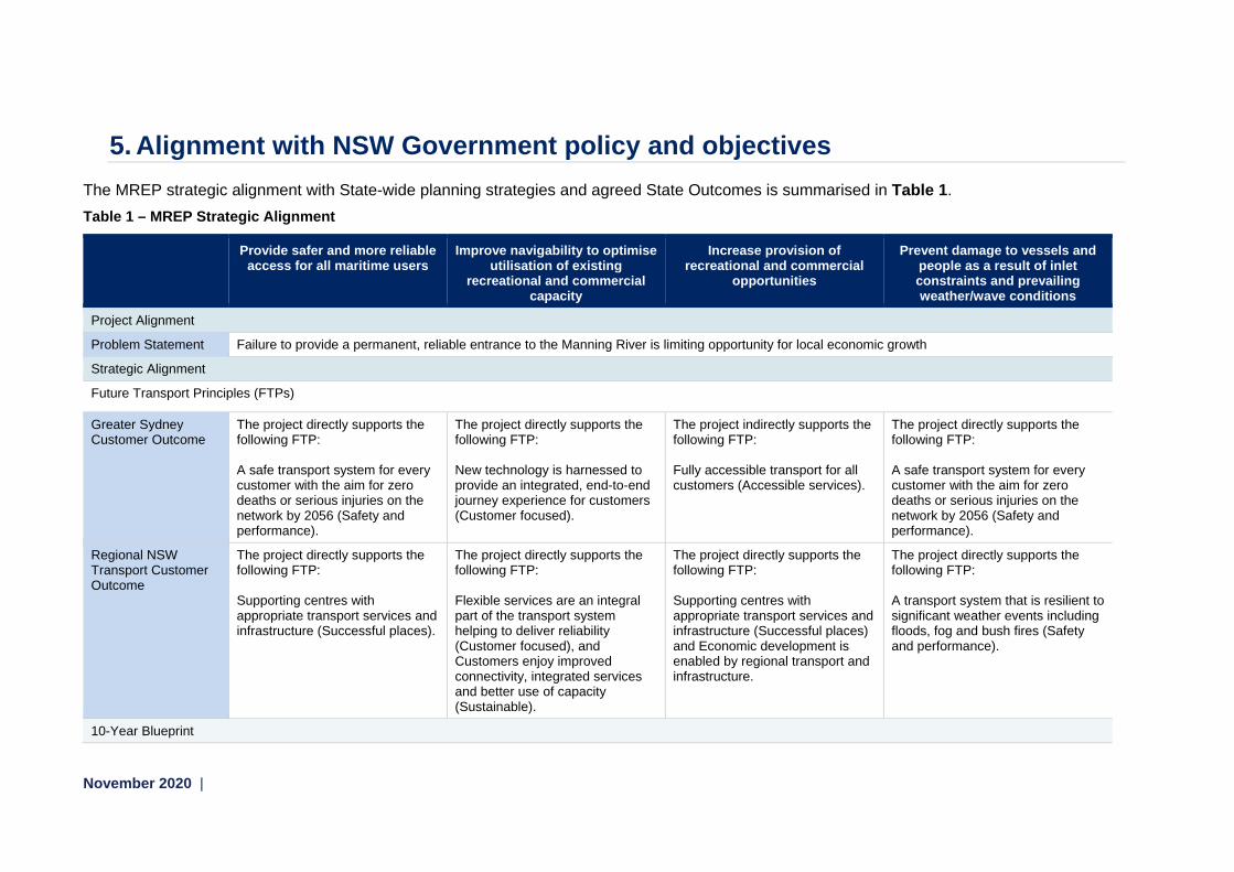
5. Alignment with NSW Government policy and objectives The MREP strategic alignment with State-wide planning strategies and agreed State Outcomes is summarised in Table 1. Table 1 – MREP Strategic Alignment
Provide safer and more reliable access for all maritime users
Improve navigability to optimise utilisation of existing
recreational and commercial capacity
Increase provision of recreational and commercial
opportunities
Prevent damage to vessels and people as a result of inlet constraints and prevailing weather/wave conditions
Project Alignment
Problem Statement Failure to provide a permanent, reliable entrance to the Manning River is limiting opportunity for local economic growth
Strategic Alignment
Future Transport Principles (FTPs)
Greater Sydney Customer Outcome
The project directly supports the following FTP: A safe transport system for every customer with the aim for zero deaths or serious injuries on the network by 2056 (Safety and performance).
The project directly supports the following FTP: New technology is harnessed to provide an integrated, end-to-end journey experience for customers (Customer focused).
The project indirectly supports the following FTP: Fully accessible transport for all customers (Accessible services).
The project directly supports the following FTP: A safe transport system for every customer with the aim for zero deaths or serious injuries on the network by 2056 (Safety and performance).
Regional NSW Transport Customer Outcome
The project directly supports the following FTP: Supporting centres with appropriate transport services and infrastructure (Successful places).
The project directly supports the following FTP: Flexible services are an integral part of the transport system helping to deliver reliability (Customer focused), and Customers enjoy improved connectivity, integrated services and better use of capacity (Sustainable).
The project directly supports the following FTP: Supporting centres with appropriate transport services and infrastructure (Successful places) and Economic development is enabled by regional transport and infrastructure.
The project directly supports the following FTP: A transport system that is resilient to significant weather events including floods, fog and bush fires (Safety and performance).
10-Year Blueprint

Report of the Manning River Taskforce November 2020 16
Provide safer and more reliable access for all maritime users
Improve navigability to optimise utilisation of existing
recreational and commercial capacity
Increase provision of recreational and commercial
opportunities
Prevent damage to vessels and people as a result of inlet constraints and prevailing weather/wave conditions
Primary Outcome (PO)
The project indirectly supports the following PO: Safe seamless journeys for people and goods (connecting our customer’s whole lives).
The project indirectly supports the following PO: Growing people, culture and capability (thriving people doing meaningful work)
The project directly supports the following PO: Transport investments and solutions that service the people of NSW (strong economy and quality of life)
The project directly supports the following PO: Protecting and enhancing communities and their environments (successful places).
State Outcomes14 (SO) and Premiers Priorities (PP)
Aligned to: SO: Safe and reliable travel PP: A strong economy, quality jobs and job security for workers of today and tomorrow
PP: A strong economy, quality jobs and job security for workers of today and tomorrow, and Well-connected communities with quality local environments
SO: Successful places PP: A strong economy, quality jobs and job security for workers of today and tomorrow, and Well-connected communities with quality local environments
SO: Safe and reliable travel PP: Well-connected communities with quality local environments
Indicative timeframe for implementation
Medium term (6-10 years) Medium term (6-10 years) Short term (0-5 years) Short term (0-5 years)
State Infrastructure Strategy 2018-2038
Responds to key transport challenges and recommendations: Unlock capacity in existing assets (addressing capacity constraints).
Responds to key transport challenges and recommendations: Addressing local regional constraints.
Responds to key transport challenges and recommendations: Overcoming local regional constraints.
14 State Outcomes to be delivered by NSW Treasury cluster (NSW Treasury, 2019).

November 2020 |
6. Scope to take forward Options to address navigability and safety of the Manning River Entrance
A number of previous studies have been undertaken to investigate the issues associated with the entrance to the Manning River, and possible interventions that would improve safety and access. These preceding studies identified a variety of possible options including:
• Base Case – Status quo/do nothing • Enhancement of an alternative harbour • Routine dredging scheme • Relocation of the gantry • Creation of a tombolo • Manning Point sand pit stabilisation • Southern entrance breakwater • Manning Point twin breakwaters
These options have been assessed at a preliminary level for their feasibility and merits using a Multi-Criteria Analysis and peer review process.15 Based upon the expert engineering advice provided to the Taskforce, a short list of options was identified for further analysis in a future phase of the Project’s development. The short-listed options are:
• Base Case – Do nothing/Status quo • Do Minimum – Routine dredging scheme (Option 1) • Southern entrance breakwater (Option 2) • Manning Point twin breakwaters (Option 3)
The sand pit stabilisation and tombolo options were discounted due to uncertainty of longevity of these options, which could mean significant investment in an option which may prove to be short term only. The gantry re-location was considered a secondary option only, as it is unlikely to impact on the stability of the entrance. The enhancement of an alternative harbour does not meet the fundamental objectives of the project, as it would not address improved access and safety to the Manning River entrance.
Base case – Status quo/Do nothing
Further investigation of the base case of ‘do-nothing’ is required to better understand the risks and issues of not progressing with any intervention. The base case reflects the status quo, as some ad-hoc dredging has occurred but this is sporadic and unplanned.
Do minimum- Routine dredging scheme
Description of proposed works A routine dredging scheme option would require regular dredging to maintain accessibility to the entrance. The extent of the dredging would be in the order of 400,000 cubic metres every five
15 See analysis contained within Manning River southern Breakwater Feasibility study, 2019 and Manning River’s Harrington Entrance Expert Workshop Summary Report, 2020.
Report of the Manning River Taskforce November 2020 18
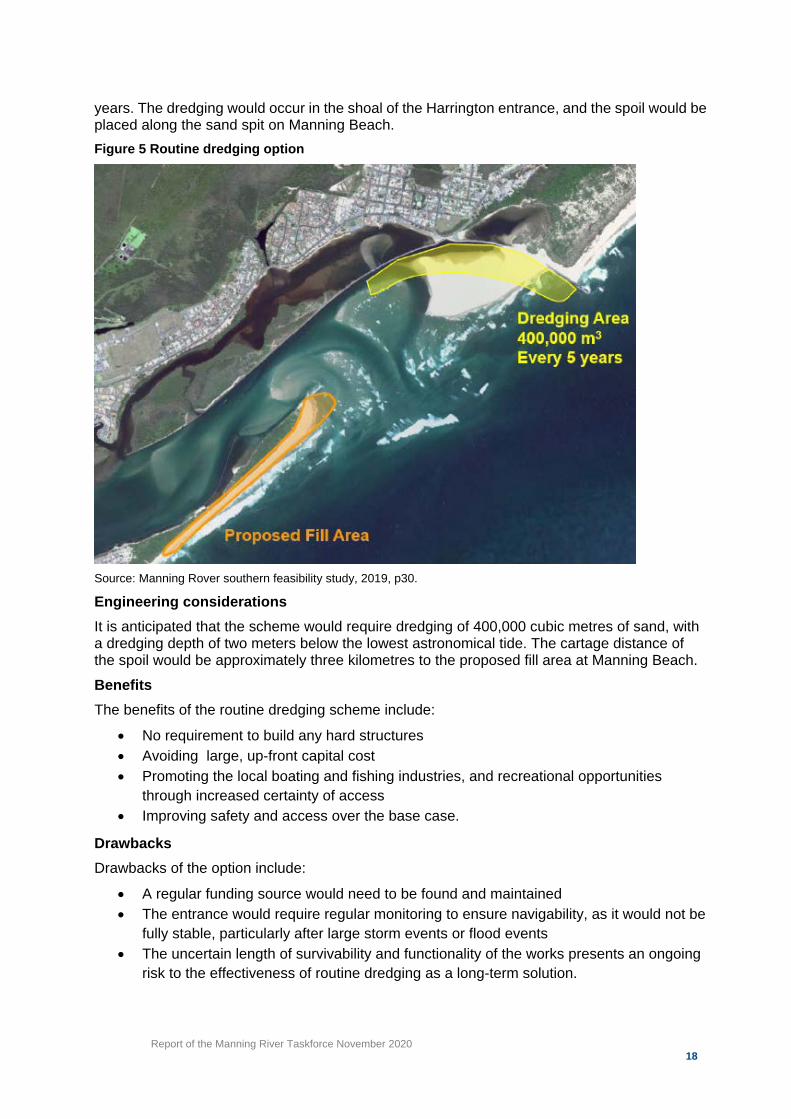
years. The dredging would occur in the shoal of the Harrington entrance, and the spoil would be placed along the sand spit on Manning Beach. Figure 5 Routine dredging option
Source: Manning Rover southern feasibility study, 2019, p30.
Engineering considerations It is anticipated that the scheme would require dredging of 400,000 cubic metres of sand, with a dredging depth of two meters below the lowest astronomical tide. The cartage distance of the spoil would be approximately three kilometres to the proposed fill area at Manning Beach. Benefits The benefits of the routine dredging scheme include:
• No requirement to build any hard structures • Avoiding large, up-front capital cost • Promoting the local boating and fishing industries, and recreational opportunities
through increased certainty of access • Improving safety and access over the base case.
Drawbacks Drawbacks of the option include:
• A regular funding source would need to be found and maintained • The entrance would require regular monitoring to ensure navigability, as it would not be
fully stable, particularly after large storm events or flood events • The uncertain length of survivability and functionality of the works presents an ongoing
risk to the effectiveness of routine dredging as a long-term solution.
Report of the Manning River Taskforce November 2020 19
Potential costs The potential cost of this option is $4 million every five years (excluding escalation) based on current dredging costs in similar conditions. Option recommendations The routine dredging option is similar to the status quo, given the ad-hoc dredging works that occur in the area. It should be further considered for comparative purposes to assess the relative costs and benefits of the options that require the construction of hard structures, at a significant cost.
Southern entrance breakwater option
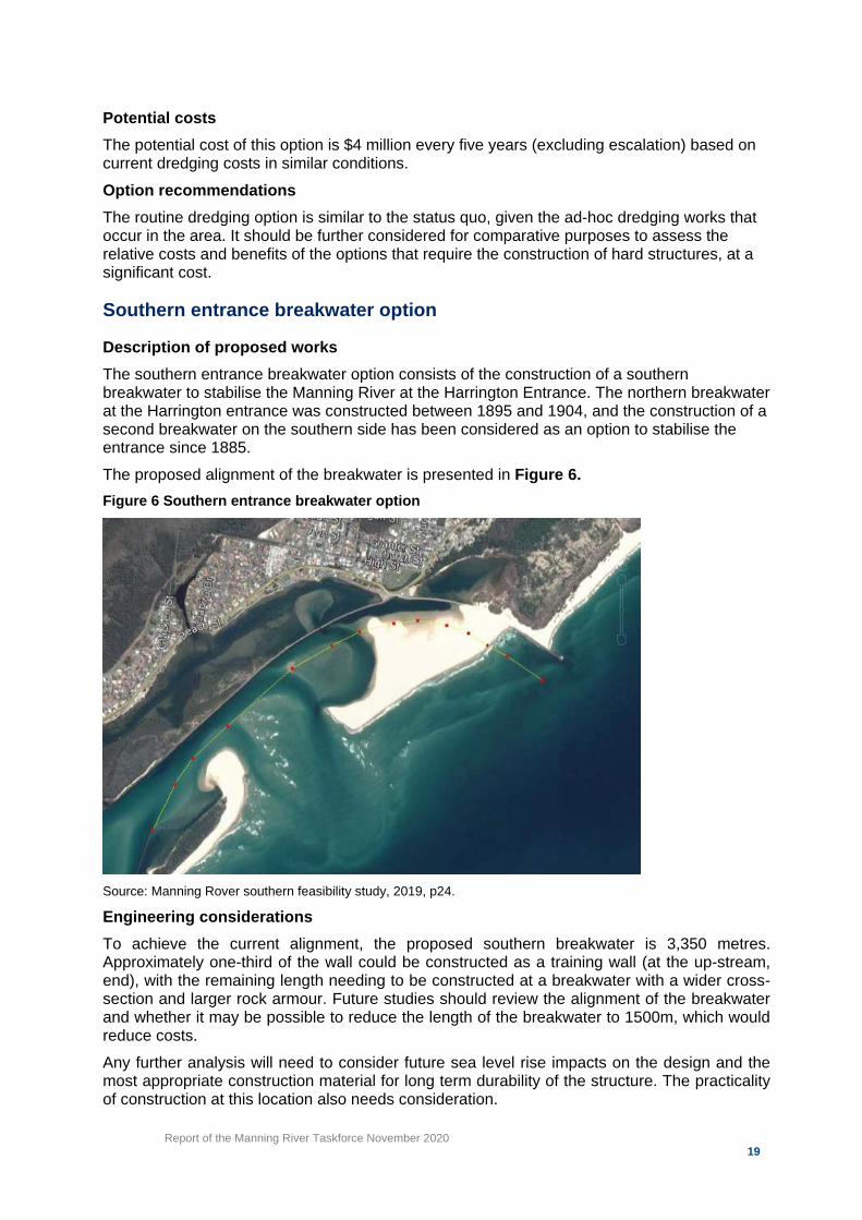
Description of proposed works The southern entrance breakwater option consists of the construction of a southern breakwater to stabilise the Manning River at the Harrington Entrance. The northern breakwater at the Harrington entrance was constructed between 1895 and 1904, and the construction of a second breakwater on the southern side has been considered as an option to stabilise the entrance since 1885. The proposed alignment of the breakwater is presented in Figure 6. Figure 6 Southern entrance breakwater option
Source: Manning Rover southern feasibility study, 2019, p24.
Engineering considerations To achieve the current alignment, the proposed southern breakwater is 3,350 metres. Approximately one-third of the wall could be constructed as a training wall (at the up-stream, end), with the remaining length needing to be constructed at a breakwater with a wider cross-section and larger rock armour. Future studies should review the alignment of the breakwater and whether it may be possible to reduce the length of the breakwater to 1500m, which would reduce costs. Any further analysis will need to consider future sea level rise impacts on the design and the most appropriate construction material for long term durability of the structure. The practicality of construction at this location also needs consideration.

Report of the Manning River Taskforce November 2020 20
Benefits The benefits of the southern entrance breakwater include:
• Improved navigation, with certain and safer access to the Manning River and entrance • A constantly open entrance generating new conditions, including improved tidal
flushing and discharge of flood water • Improved estuary health for oyster farmers and recreational fishermen • A further stabilised entrance by reducing the rate of sediment influx during the
incoming flood tide.
Drawbacks Drawbacks of this option include:
• The high capital cost • Complex and difficult constructability due to poor access to the southern side of the
entrance by land.There are safety and practical risks in brining materials in by barge or the provision of temporary bridge access from the north. Most of the structure is also required to be constructed “in the wet”
• Constructing a southern breakwater would significantly change the local hydraulic and hydrodynamic behaviour. This could adversely impact the existing northern breakwater that may require modification to withstand the higher flows and stronger currents
• The introduction of a southern entrance breakwater would generate significant changes to the existing coastal processes, which are not yet well understood
• The breakwater will eventually be bypassed and need maintenance, including possible routine dredging
• Possible riverbank erosion could result from such an option, and further investigation of the impact on flood behaviour among other factors would be required
• A permanent entrance may lead to more frequent closure of the Farquhar inlet, and therefore interaction between the Manning River entrance and the inlet needs to be considered. An open inlet at Farquhar may lead to more extensive erosion of nearby coastline, however more frequent closure could have adverse impacts on the local water quality.
• A more efficient tidally flushed entrance has uncertain impacts on tidal levels upstream that may adversely impact agricultural lands.
Potential costs The potential cost of this option could be in the order of $170 million in construction costs, and further maintenance costs would be incurred over the life of the breakwater. This figure does not include any potential costs flowing from compensation or acquisition costs of agricultural land. A shorter version of the southern breakwater (approximately 1350 metres) may also be feasible, subject to further investigation. This would reduce costs to approximately $62 million. However, such an option would need to be associated with construction and vegetation of a dune on the southern side of the southern breakwater. Construction of the dune is estimated to cost $19 million. Any solution involving the construction of a new southern breakwater is also likely to require additional reinforcement of the northern breakwater, which would add an additional cost of approximately $11 million.

Report of the Manning River Taskforce November 2020 21
Note: Theses estimate should only be used for comparative purposes and would need to be validated and further worked up through further design and due diligence activities.
Option recommendations The introduction of a southern breakwater option performs well against the project objectives, as it would provide safer and more reliable access to the Manning River, and enable increased use of the River and entrance for commercial and recreational purposes. The southern breakwater option requires further engineering and environmental analysis to determine an optimal design outcome that will minimise impact on the surrounding area and whole-of-life project costs.
Manning Point twin breakwaters
Description of proposed works The twin breakwaters entrance option is the creation of a new opening at the narrowest point of Mitchell Island sand spit. The opening of 250 – 300 metres would be stabilised by two breakwaters, each stretching 500-700 metres offshore. The option would enable the use of the existing entrance as a harbour or area for other development. Figure 7 Manning Point twin breakwaters option
Source: Manning River’s Harrington Entrance Expert Workshop Summary Report, 2020, p11. Engineering considerations Of the twin breakwaters, the southern breakwater would be longer than the northern one to reduce the impact of sediment bypassing, and align the channel in a northerly direction. The use of spoil on the southern side of this breakwater would also provide additional protection to the Manning Point township in severe coastal storms. Any further analysis will need to consider future sea level rise impacts on the design, the most appropriate construction material for long term durability of the structure, and the practicality of construction at this location.

Report of the Manning River Taskforce November 2020 22
Benefits The benefits of the Manning Point twin breakwaters option include:
• The potential for development of a harbour or marina in the old channel, and a shorter route to the ocean from developed areas which would be beneficial for the boating industry and may generate potential economic and tourism benefits
• The construction of the twin breakwaters can mostly be undertaken “in the dry” before opening the entrance, which would simplify construction.
• The shorter channel would pass flood waters more easily and would reduce the flood tide deltas (the shoals that make navigation difficult in the existing entrance)
• Constructing this option at the narrowest point of the sand spit will mitigate the risk of a natural breakout at this location and will instead enable that to occur in a controlled way.
• This option is less expensive and less complex to construct than the southern entrance breakwater option
• This option will provide additional protection to the township of Manning Point in severe storm events.
Drawbacks Drawbacks of this option include:
• While the option has potentially strong coastal engineering merits it has not been the subject of community consultation
• The option has a high capital cost and has not been the subject of detailed design works, which may alter the potential cost
• The introduction of the twin breakwaters would generate significant changes to the existing coastal and estuarine processes, which are not yet well understood
• Careful design consideration would be required for the existing wetland areas and back channel entrance directly west of the proposed breakwaters, where storm wave penetration could otherwise generate erosion
• As with the southern entrance breakwater option, interactions with the Farquhar Inlet need to be carefully modelled.
Potential costs The potential cost of this option could be in the order of $100 million in construction costs and further maintenance costs will be incurred over the life of the breakwater. This estimate should only be used for comparative purposes and would need to be validated and further worked up through further design and due diligence activities. This figure does not include any potential costs flowing from compensation or land acquisition costs in relation to agricultural lands. Option recommendations The introduction of the Manning Point twin breakwater option performs well against the project objectives, as it would provide safer and more reliable access to the Manning River and enable increased use of the River and entrance for commercial and recreational purposes. It may also have supplementary benefits as it will protect the township of Manning Point in severe storms. However, this option has not been subject to community consultation. The Manning Point twin breakwater option requires further engineering and environmental analysis to determine an optimal design outcome, which minimises impact on the surrounding area and whole-of-life project costs.
Report of the Manning River Taskforce November 2020 23
Supporting activity
There are multiple levels of government involved in the management of the coastline in NSW. Within the State government, Transport for NSW has primary carriage of maritime infrastructure planning and delivery. However, additional departments including the Department of Regional NSW and the Department of Planning, Industry and Environment, and also have important roles to play. The MCC has obligations for developing and managing the coast under the Coastal Management Act 2016. MCC is in the process of developing its Coastal Management Plan, which will impact on the next steps for the MREP project. While work has been done on the development of technical options, NSW Government has not yet had the opportunity to consult extensively with the local community on the project, and its benefits and risks. It is important that the community understand the trade-offs required with each of the options. For example, the extent to which intervention at Harrington may impact on the Farquhar Inlet and vice versa. As with any stakeholder engagement activities, guiding principles need to be established to direct efforts and achieve a mutually acceptable outcome. Engagement must be:
• Purposeful: Engagement should have a clear purpose, scope and outcomes. • Inclusive: All relevant stakeholders should be identified and included, ensuring a
diversity of people and range of opinions. • Timely: Engagement should be timely with stakeholders involved from the beginning
and knowing when to expect engagement and how often. • Considered: Engagement should provide opportunities for feedback, suggestions and
ideas. The expertise, perspective and needs of different stakeholders should be acknowledged, respected, and considered where appropriate in decision making processes.
The Taskforce considers stakeholder engagement as an enabler, and understands that to maintain the momentum that the MREP project has recently gained, it is important that all of the various objectives and priorities of government and community are clearly understood and appropriately considered. This will require substantial engagement with the local community and MCC, as well as across NSW Government to foster understanding, support and collaboration.
Report of the Manning River Taskforce November 2020 24
7. Taskforce Recommendations The Taskforce reviewed options to improve safety and access to the Manning River, and it is clear that further engineering and consultation work is required to determine the best outcome for the entrance, and the impacts on the broader geographic area, including Farquhar Inlet. Recommendation 1: The Taskforce recommends that the project is entered into the Infrastructure NSW Investor Assurance and NSW Treasury business case process. The development of a Strategic Business Case (SBC) is required to further analyse the optimal engineering outcome, the broader impacts of intervention in the area, and the relative costs and benefits of the identified options. If the benefits are found to outweigh the costs of the project, a more rigorous engineering, constructability, and environmental impact assessment should be undertaken in a Final Business Case prior to a decision to invest in a permanent solution. Further detail on the scope, duration and governance requirements for SBC is provided at Attachment 3. Recommendation 2: It is recommended that any future process should be supported by an extensive stakeholder consultation process that includes the local community and impacted industries and stakeholders as well as consideration of progress in the development of Mid-Coast Council’s two CMPs. Broader stakeholder consultation will enable greater understanding of the potential economic benefits and risks of a permanent entrance, including the appetite for any supplementary development.

November 2020 |
Attachment 1 – Manning River Taskforce Terms of Reference
Manning River Taskforce Terms of Reference
May 2020
Context Local stakeholders have claimed that a safer and more reliable entrance to the Manning River would bring significant economic benefits to the region by enhancing recreational boating, fishing activity and increasing opportunities for private sector investment in marinas and other marine based industries.
The issue has been subject of much consideration over many decades, including most recently in a 2018 Feasibility Study undertaken by Manly Hydraulics Laboratory (a NSW government agency and specialists in water and coastal engineering) on behalf of the former NSW Department of Industry. The study looked at options for improving the entrance and found that construction of a southern breakwater is technically feasible and would likely reduce shoaling and improve the stability of the entrance. Given the significant capital and recurrent costs, the study suggested that economic benefits in the order of $200 million would need to be demonstrated for the proposal to achieve a favourable cost benefit ratio as part of an economic appraisal.
The study considered a range of other options including routine dredging, stabilisation of the Manning Point sand spit and the creation of an artificial tombolo using large sandbags. While all of these options are substantially less expensive, the study identified concerns about the longevity of these solutions given the significant changes in dynamics at the river entrances that can occur following major flood or weather events.
Purpose The objective of the Taskforce is to build on the work from the 2018 Manly Hydraulics Laboratory study by providing expert advice to NSW Government about the expected economic benefits that could be generated by a permanent entrance to the Manning River at Harrington, the optimal engineering solution and consideration of how such a proposal could be designed and delivered in the context of the requirements of the Coastal Management Act 2016. This will also include consideration of issues
The Taskforce will also consider implications for potential improvements at the southern entrance of the river at Farquhar Inlet.

Report of the Manning River Taskforce November 2020 26
Membership The Taskforce membership draws on government, industry and local knowledge from individuals and/or representatives of organisations who hold relevant experience. The Taskforce is comprised of 8 members:
• Andrew Mogg – Transport for NSW, NSW Maritime (Chair)
• Anna Zycki – Transport for NSW, Regional and Outer Metropolitan
• Asher Miners – Office of the Minister for Transport and Roads
• Professor Bruce Thom – Coastal Expert
• Darren Vaux – Boating Industry Association
• Adrian Panuccio – Mid Coast Council
• Chris Hanger – Department of Regional NSW
The Taskforce can be further supported by additional individuals with specific skill sets (e.g. coastal engineering, infrastructure etc.) as options are considered.
Meetings The Manning River Taskforce will meet monthly (or as required).
Secretariat Support A Taskforce Secretariat will be appointed by NSW Maritime. Meeting minutes will be prepared by the Secretariat and distributed to members within one week of each meeting.
Key deliverables A final report outlining the options to provide a permanent entrance to the Manning River will be issued via a briefing note to the Minister for Transport and Roads, and the Minister for Regional Transport and Roads.
Expenses and Related Allowances Members of the Taskforce will not be remunerated for participation. Members will be reimbursed for travel expenses incurred in relation to site meeting attendance. Expenses incurred must be supported by receipts and all reimbursement claims are to be lodged with the Secretariat.
Personal and Professional Behaviour Taskforce members will undertake their role using due care, honesty and integrity. Communication will be open and constructive.
Public Comment Members will not make public comment on behalf of the Taskforce without the specific agreement of the Chair. It is understood that as a citizen (and in performing other professional roles) members have the right to make comments and enter into public debate, providing it is not perceived to be an official comment on behalf of the Taskforce.

Report of the Manning River Taskforce November 2020 27
Conflict of Interest Representatives are to declare any potential or actual conflicts of interest as and when required and, if necessary, remove themselves from certain discussions.
Confidentiality Taskforce members may have access to confidential information which must not be disclosed. Members agree to be bound by this protocol both during the term of their membership and following the completion of the Taskforce.

November 2020 |
Attachment 2 – Reference reports
Old Bar Coastal Erosion Study16 (1982)
Manning River Entrance Study – Background and Issues of Concern17 (1987)
Manning River Estuary Processes Study18 (1997)
Manning River Estuary Management Study – Numerical Modelling Report19 (2001)
Manning River Entrance Improvement Project – Economic Scoping Study20 (2003)
Manning River Estuary Management Study21 (2009)
Greater Taree Coastline Management Study Black Head to Crowdy Head22 (2010)
Manning River Maintenance Dredging Strategy 2010-2015
Manning River Southern breakwater feasibility study (2018)
16 Sinclair, Knight & Partners, 1982, “Old Bar Coastal Erosion Study” 17 PWD, 1987, “Manning River Entrance Study – Background & Issues of Concern” 18 Webb, McKeown & Associates, 1997, “Manning River Estuary Processes Study” 19 WBM, 2001, Manning River Estuary Management Study – Numerical Modelling Report 20 Rolyat Services, 2003, “Manning River Entrance Improvement Project – Economic Scoping Study” 21 WorleyParsons, 2009, “Manning River Estuary Management Study” 22 Worley Parsons, 2010, “Greater Taree Coasltline Management Study Black Head to Crowdy Head”

November 2020 |
Attachment 3 – Strategic Business Case – scope and governance
SBC Scope
Purpose
One of the recommendations of the Manning River Taskforce is the development of a Strategic Business Case (SBC) for a permanent entrance to the Manning River at Harrington (the Project). Undertaking further analysis in the form of an SBC will enable Transport for NSW (TfNSW) to:
• Assess the feasibility and practicality of each of the proposed options • Provide a cost benefit analysis for each of the options (against the base case) • Quantify the estimated cost of the options • Undertake structured stakeholder and community engagement regarding the project
and proposed options • Provide recommendations on a short list or preferred of option for detailed analysis in a
Final Business Case.
This document describes the Project scope for the preparation of the SBC, including, but not limited to, the shortlist of project options identified by the Taskforce:
• Base case – status quo/do nothing • Do minimum – routine dredging scheme (Option 1) • Southern entrance breakwater – (Option 2) • Manning Point twin breakwaters (Option 3)
SBC Scope The SBC will be prepared in accordance with the NSW Treasury Guidelines for Capital Business Cases (TPP18-06), and the Infrastructure NSW (INSW) Infrastructure Investor Assurance Framework (IIAF). The Cost Benefit Analysis (CBA) within the SBC will be undertaken in line with the NSW Treasury Cost-Benefit Analysis Guidelines (TPP17-03) and with consideration to the Transport for NSW Cost-Benefit Analysis Guide.
The analysis within the SBC should include the following elements:
I. Description of the Problem a. Further analysis of the case for change, including definition of the investment
logic and rationale for a permanent entrance b. Survey studies of peak and non-peak usage and likely consumer behaviour in
response to a permanent entrance. II. Strategic Alignment
a. Further assessment of the strategic priority of the project and alignment with key NSW Government priorities.
III. Options Development a. Further analysis of the impacts and implications of the ‘do-nothing’ option,
including flood studies and a coastal hazard assessment b. Confirmation of the quantities and frequency of the routine dredging option c. Concept level design development of the breakwater options, including
alternative options for length and different construction methods d. Engineering studies including:
i. Hydrology and land surveys of the area

Report of the Manning River Taskforce November 2020 30
ii. Estuary Modelling & Hydraulic Modelling for baseline water quality and riverbank erosion, sand transport changes, tidal prism, dual entrance gradients and interactions
iii. Scenario testing of the various options to assess the hydrodynamic impacts on the surrounding area, including impacts on the Farquhar Inlet.
e. Review of the planning approval pathway and key environmental issues and considerations for each option including:
i. Assessment of the impact on marine ecology ii. Assessment of the impact on surrounding waterways and landscape,
including Farquhar Inlet and Harrington Waters iii. Consideration of heritage, including indigenous heritage
issues/constraints iv. Consideration of other potential environmental impacts of the option.
IV. Cost Analysis a. Completion of detailed costing for each option which would need to consider:
i. Design and engineering outputs ii. plant and quarry availability of materials for breakwater structures iii. outcomes of a market sounding exercise with potential contractors.
b. Estimated capital, operating and recurrent cost of the options for a period of 30 years
c. Identification and quantification of key Project risks including option specific risks, and costing of any significant controls that are required to be implemented based on the risk assessment.
V. Strategic Assessment of the Options a. Further development and refinement of the multi-criteria analysis b. Development of a Cost Benefit Analysis c. Development of a Financial Appraisal and Financial Impact Assessment in line
with the NSW Government Guidelines d. Funding analysis identifying funding options, likely sources of funding, and
threshold approval requirements e. Market sounding of the building industry to understand the constructability and
practical implications of the construction of the project f. Lessons learnt from other relevant Australian and international projects.
VI. Project Management a. Ongoing governance arrangements (see below) b. Stakeholder engagement and consultation activities and planning c. A risk management plan that identifies risks and mitigation for all project options
in accordance with TfNSW’s Enterprise Risk Management Policy, Risk Management Framework, as well as AS/NZS ISO 3100:2009 Risk Management
d. Procurement and delivery planning for the options.
Timing
Based upon engineering advice and benchmark maritime projects undertaken by Transport for NSW, a SBC of this nature is expected to take approximately 12 – 18 months, once a project team is established and can commence work.
Report of the Manning River Taskforce November 2020 31
A high-level project programme through the SBC and FBC has been prepared by Transport for NSW to assist the Taskforce in its report. The mandatory milestones and activities included within the schedule are summarised below, noting the start and completion dates for each item are indicative only. The MREP holds no dependency on any other alternative or concurrent activities. However, the project will require consistent and coordinated stakeholder communication and consultation. A detailed stakeholder management plan should be developed as part of the SBC stage.
Resourcing Arrangements
Transport for Maritime will have responsibility for the preparation of the SBC and will engage suitably qualified consultants and technical experts as required
Project Governance
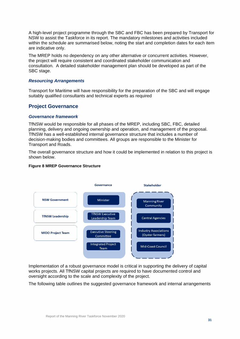
Governance framework TfNSW would be responsible for all phases of the MREP, including SBC, FBC, detailed planning, delivery and ongoing ownership and operation, and management of the proposal. TfNSW has a well-established internal governance structure that includes a number of decision-making bodies and committees. All groups are responsible to the Minister for Transport and Roads. The overall governance structure and how it could be implemented in relation to this project is shown below.
Implementation of a robust governance model is critical in supporting the delivery of capital works projects. All TfNSW capital projects are required to have documented control and oversight according to the scale and complexity of the project. The following table outlines the suggested governance framework and internal arrangements
Figure 8 MREP Governance Structure

Report of the Manning River Taskforce November 2020 32
Table 2 – Governance roles and responsibilities
Roles Responsibilities
Governance arrangements
Executive Steering Committee (ESC)
The project is required to report to an executive level steering committee (ESC). The ESC is responsible for approving and providing key direction on decisions concerning both the project and overarching program. Given the level of interaction with Mid-Coast Council, it is suggested the ESC for the SBC stage should comprise the following:
• Executive Director, TfNSW Maritime. • Nominated representative, Mid-Coast Council • Nominated representative, Department of Regional NSW • Nominated representative, DPIE, Crown Lands and EES • Independent expert(s)
Project Control Group (PCG)
The PCG reports to and takes direction from to the ESG. The PCG is responsible for approving and providing key direction on decisions that do not require endorsement of the ESC yet concern both the project and overarching program. The PCG should comprise the following:
• Director, TfNSW Maritime Infrastructure Delivery Office • Project Manager, TfNSW Maritime Infrastructure Delivery
Office • Technical and business case consultants as required • Additional members as appropriate
Project Director (PD)
Director, MIDO is the PD for the SBC. The PD is required to lead the project team and provide oversight on the SBC process and deliverables.
Project management arrangements
Senior Project Manager (SPM) SPM, MIDO is required to supervise the project team and escalate matters and key considerations to the PD for review, approval or endorsement.
Project Manager (PM) PM, MIDO is responsible for the day-to-day management of the project, the project team and project deliverables according to programme. The PM reports to the SPM.


![NSW Decentralisation Taskforce Report [ - 677.8 KB]](https://img.dokumen.tips/doc/110x75/6207410549d709492c2f89ba/nsw-decentralisation-taskforce-report-6778-kb.jpg)