Embed Size (px)
Citation preview
Please Quote Ref: LG/9/WRCDR:GHlSSl
16 November 2000
Wellington Regional CouncilP OBox 11646WELLINGTON
Attention: Tony Brennand
Dear Sir
REPORT FOR REGIONAL LAND TRANSPORT COMMITTEE
Set out below is a report to the Regional Land Transport Committee (RLTC) on anumber of projects being undertaken in the region by the Wellington office of TransitNew Zealand (Transit).
Attached are copies of recent newsletters and publications, namely:
1. SHl : Waikanae to Himatangi Strategy2. SHl - Beach Road Intersection, Paekakariki.3. Media Release: SHl Pukerua Bay to MacKays crossing4. SHl - Plimmerton to Pukerua Bay.5. SH2 - Dowse to Petone Upgrade6. October issue of “Top n Tails”7. Letter to WRC sent to all Territorial Authorities
At the previous meeting the RLTC discussed reports from the road controllingauthorities and the Regional Council (in terms of passenger transport) as a form ofimplementation report of the Regional Land Transport Strategy (RLTS).Accordingly, I have structured the report below in a similar manner to the RLTS.
WESTERN CORRIDOR
RLTS Corridor Plan:
Roading Projects to 2004
. Construct a new two-lane bridge at Paremata ($4.3~1)
. Complete the sufety improvements on State Highwuy I north of Paremutn($8.7m).
W e l l i n g t o n R e g i o n a l O f f i c e
2nd Floor,Transport House l 275 - 283 Cuba Street l PO Box 27 477 . W ellington . N e w Zealand
Telephone 04 801 2580 l Facsimile 04 801 2599

Complete the su$ety improvements at McKrlys Crossing ($12.3m).
Implement the Active Trafjc Management System nt Ngnurnnga Gorge md
three lanes in each direction south to the State Highwrlys 1 and 2 merge(Urn).
Construct the river crossing stage of the Kapiti Local Connecting Road($3 7m).
Provide other sufetp and capacity improvements on Stage Highway I betweenPurematu and McKays Crossing appropriate to the timing of theTransmission Gully (new project).
Develop proposals for the future of the existing State Highway withappropriate agencies for once Transmission Gully is built.
Resolve funding, legislative and resource management issues relating toTransmission Gully, purchase required land and commence construction ifpossible.
Roading Projects Beyond 2004
. Construct Transmission gully as a toll road as soon us possible ($233m;
. Construct the remainder of the Kapiti Local Connecting Road ($24m).
SHl: Himatangi to Waikanae Strategy Study
In October 2000, the Transit Authority considered a strategy for State Highway 1between Waikanae and Himatangi comprising:
(1) A four lane highway in or near the existing corridor between Waikanae(Peka Peka Road) and Levin;
(2) A two lane eastern bypass of Levin;
(3) Retaining the existing two lane highway north of Levin withimprovements comprising seal widening, additional passing lanes anda short realignment south of Foxton.
This draft strategy will be used as the basis of consultation with the Kapiti Coast andHorowhenua District Councils, community boards and other interested parties will beconsidered next year by Transit to confirm the strategy (amended as necessary) asappropriate.
Regarding the section of SHl within the Wellington region, the draft strategyproposes four laning primarily on the existing alignment from Waikanae to just southof Otaki, and then an eastern bypass around Otaki. Initial project economics indicatethat it is appropriate to now make further progress on the planning for the four laningof the existing section south of Otaki and investigate further the eastern bypass ofOtaki, noting that it is likely to be some years before construction of the Otaki Bypass
2
- - - *.m

is justified.Submission.
Further details are included in the attached Transit Authority
SHl: Waikanae to Poplar Avenue Strategy Study
This strategy study considers the long term development of this section of SHl. Itaccepts that the Western Link Road (WLR) being jointly taken between Transit andthe Kapiti Coast District Council (KCDC) is expected to be progressively constructed,with initial construction programmed to commence in 2004. The results of thisstrategy study are expected to be reported early in the new year.
SHl: Hadfields Road to Peka Peka Road
Transit has recently obtained the necessary planning consents and land required forthis $l.lM project. The project will be constructed as soon as funding is available.The project provides for straightening of the road as the first stage of improvements toSHl through this section, with the second stage to be undertaken when the highway iseventually four laned.
SHl: Vicinity of Otaihanga Road
The high accident rate on this section of SHl has resulted in Transit initiating detailedinvestigation for improvement of this section of SH 1. While a number of small scaleimprovements have been undertaken at the intersection over the last five years, asignificant accident history is still apparent at the intersection, due both to turningvehicles and loss of control accidents for state highway traffic.
SHl: Lindale to Nikau Palms Drive, North of Paraparaumu
The proposed $2M project provides for construction of an underpass for the twoconnecting side roads, with full turning movements provided for by on /off ramps.The high quality access will also provide for all turning movements in and out of theLindale tourist complex, with the existing entrance on to SHl being closed onceconstruction is complete.
The project has recently received the necessary planning consents, and design isalmost complete. The design is consistent with future four laning. Funding forconstruction will be sought to allow a start in early 2001.
SHl: Poplar Avenue to MacKays Crossing (Raumati Straight)
The contract for this $2.3M project was awarded in October, and construction hascommenced to widen the carriageway and provide a median barrier to separateopposing traffic. It is anticipated that this project will take eighteen months toconstruct, including a winter close-down period in 2001 to allow for settlement of theadditional formation width on the western side of the existing highway.
3

SHl: MacKays Crossing
Applications for the designation and necessary resource consents will be made shortlyfor this project. The project will provide four lanes across the North Island MainTrunk Rail line, and it’s two stage construction will provide the northern terminationof the Transmission Gully Motorway (TGM).
The first stage provides for the rail crossing with the new alignment crossing the railssome 200 metres north of the existing crossing, and the route rejoining SHl on thefirst straight south of the existing crossing.
The second stage will be constructed when TGM is constructed, and provides for newalignment passing west of the existing highway through the Sang Sue property andthen looping back across existing SHl and south toward the Wainui Saddle.
SHl: MacKays Crossing to Pukerua Bay
In my last report to the RLTC, I noted that Transit had reacted to an emergingaccident pattern on this section of road by reducing the speed limit of Beach Road to80 km/l-u to increase awareness by motorists of the intersection. Since that time,Transit has investigated a number of measures which are aimed at making thishighway particularly conspicuous for motorists in a way such that they will improvetheir behaviour on this section of SHl. Attached is a press release which details theresponses proposed, most of which will be installed prior to Christmas.
SHl: Pukerua Bay Bypass
This project is still “on hold” pending confirmation of the timing of construction ofTGM. Transit has however bought two properties over the last two years as a resultof widespread knowledge of the project within the community making properties onthe preferred alignment unmarketable.
SHl: Pukerua Bay to Plimmerton
This $9.3M project is proceeding on programme for completion in August 2001.Approximately two thirds of the earthworks have been completed and it is anticipatedthat pavement construction will commence over the next month. Porirua CityCouncil (PCC) are expected to confirm shortly funding of the off-road cyclewaybetween the highway and the Taupo Swamp which will be constructed as part of thecontract works.
SHl: Plimmerton to Paremata
The Environment Court hearing commenced on 28 August and involved 11 days incourt. Subsequently Transit, PCC and WRC have agreed most of the conditionswhich should be attached to the designation for the project with the appellants, in theevent the Court approves the Notice of Requirement. The appellants,notwithstanding agreement on most of these conditions, maintain their view that theproject should not proceed.
4

It is uncertain when a result from the Environment Court will be available, howeverassuming a positive outcome in the early part of 2001, then completion ofconstruction of the $18.4M project is expected to be in the 2002/2003 year.
SHl : Whitford Brown Intersection
Additional options to consider grade separation are being considered in consultationwith PCC. The project economics recognise the uncertainty of timing of TGM andthe result of the investigations are now expected to be reported early next year.
Transmission Gully Motorway (TGM)
Transit is progressing a number of appeals to the designation arising from the hearingin front of independent commissioners in 1997. A further mediation hearing washeld with the Tawa Community Board (TCB) of the Wellington City Council on 14November. Further work and discussions with Transit and TCB will occur early inthe new year. Transit is hopeful of a suitable settlement.
Other appeals are being progressed, however the appeal by the Paremata Residents’Association related to the eight year time frame for advance ecological mitigation isthe most substantial.
In recognition of the desire for early construction of the Transmission GullyMotorway, the Transit Authority resolved in October to proceed with all activitiesrequired to enable early construction of the route. Specifically this includes thefollowing:
(1) Proactive property acquisition (or securing of necessary leases) forcritical properties or those required for early ecological or landscapemitigation works. (Transit currently owns twelve of the 62 requiredproperties).
(2) Further investigation and preliminary design work necessary to supportWRC consent applications.
(3) Development of a detailed procurement strategy. This activity isparticularly necessary as it has an interaction with the strategy requiredto obtain the remaining consents for the route.
Transit is working with the Department of Conservation and WRC staff in order todevelop a sound strategy for obtaining the necessary consents.
A letter was forwarded to each of the territorial local authorities (copy attached)which details the future activities.
Transit’s view is that the earliest possible completion date of TGM is the end of 2006,assuming that mitigation works are only required for three years. Transit hasidentified that the major risks to the completion date, and their effect are as follows:
5

Compulsory land acquisition. If this is required then it is likely thatcompletion of the route will not be possible until 2007.
(2) If substantial appeals are lodged against the WRC consents, thencompletion of the route could be held up until the end of 2008.
These completion dates require that funding for early construction, including anysupporting legislation, for early construction must be in place by mid 2002.
Key risks for the early delivery of TGM are as follows:
(1)
(2)
Inability to secure funding/legislation for TGM.
Inability to secure funding for fees for essential preparatory work,particularly related to WRC consents, procurement strategydevelopment and land purchase as described above.
(3) Inability to secure resource consents in a suitable form to alloweconomic construction of the route.
(4)
(5)
Potential technical difficulties in the design.
Increased cost estimates after detailed investigation and design workhas been completed.
SHl: Ngauranga Gorge Active Traffic Management System (ATMS)
The system is currently being tested, and members’ who travel through this sectionwill have observed this in progress. It is anticipated that the system will be fullycommissioned within the next month. For the first few months, the highway will bemaintained at 80 km/hr until motorists become familiar with the operation of thevariable messages, at which time the variable speed limit will then be operated toimprove traffic flows, particularly during times of peak demand, or accidents. Oncemotorists have become familiar with the system, then at a 100 km/hr speed limitduring low flow conditions and good weather will occur.
NGAURANGA TO WELLINGTON CBD
RLTS Corridor Plan
Reading Projects to 2004
. Construct the Ngauranga-Aotea tidalflow system ($lbm)
. Construct the next phase of the inner city bypass through Buckle andArthur Streets ($26m); and
. Enhance traffic management to improve pedestrian and vehicle flows($Zm).
6

Ngauranga to Aotea Capacity Improvement
The Terms of Reference for the detailed scheme assessment is currently with theWellington City Council (WCC). The Terms of Reference recognise that the WCCstreet network has only limited ability to accept traffic at an increased rate during themorning peak. Development of the detailed proposal for capacity improvement,including provision of a moveable lane barrier will be developed in the early part of2001.
SHl: Wellington Inner City Bypass - Stage 2 (WICB2)
Transit is awaiting a response from Transfund on the funding application for thedetailed design of this project. The project has been independently peer reviewed andshows a B/C of 3.8 based on tangible benefits, and 4.2 including other non road userbenefits. Transit holds all the necessary land and consents for the project.
Transfund have engaged an independent reviewer to further consider the project.Subject to funding being confirmed by Transfund, it is expected that the first work onsite will occur in the first half of next year.
WELLINGTON SOUTH TO AIRPORT
RLTS Corridor Plan
This corridor covers that area of Wellington City south and east of the BasinReserve through to the Wellington Airport.
Roading Projects to 2004
. Undertake further investigation of this transport corridor with relevantreading and transport authorities
Projects beyond 2004
. Investigate alternative solutions, and if cost effective construct Mt VictoriaTunnel duplication in conjunction with a road toll on the tunnels ($SOm).
SHl: Basin Reserve
See attached “Top n Tails”. The consultative working group has met twice, and it isexpected that a short list of options will be presented to WCC in February and usedas a basis to further develop the long term strategy for this key traffic junction.
WAIRARAPA CORRIDOR: MASTERTON TO UPPER HUTT
RLTS Corridor Plan
Roading Projects to 2004
7
l Construct improvements 017 the Kaitoke Hill Road ($/Om),
. Maintain continuous improvements 017 the Rimutaka Hill Road,
. Complete the 70 kph standard design jbr the Rimutaka Hill Road,
. Develop passing lanes on the Featherston-Masterton Road.
Projects beyond 2004
. Develop the Rimutaka Hill road to 70 kph standards ($3Om),
. Develop additional passing lanes on the Featherston-Masterton Road.
SH2: Mt Bruce to Featherston Strategy Study
The strategy study is currently being finalised and will be reported to the TransitAuthority shortly. Key outcomes are the ongoing development of passing lanesbetween the four Wairarapa townships, and specific improvements such as WaiohineBridge (see below) and sections of highway where land use causes significantinteraction with passing traffic (eg the fruit stalls north of Greytown). Theseidentified deficiencies will be the subject of more detailed investigation work over thenext year.
SH2: Waiohine Bridge
This relatively narrow highway bridge over the Waiohine River north of Greytownhas caused significant adverse comment from road users over the years however theaccident history for the bridge itself is relatively minor, notwithstanding a number ofanecdotal reports to the contrary. The bridge provides a constriction in the WaiohineRiver, and contributes to the higher flood levels in the river and surroundingfloodplain north of Greytown.
Transit has been working closely with the South Wairarapa District Council (SWDC)and WRC on a scheme to replace the bridge with a wider structure, and carry thewater level area to meet the desires of both agencies, and the local community.Transit has recently received the detailed investigation report, and will be reviewingthis over the next several weeks. An outcome from this report is expected early inthe new year.
SH2: Rimutaka Hill
Transit is currently seeking tenders for development of the detailed strategy for SH2over the Rimutaka Hill. This recognises the development to 70 km/hr standards in theRLTS and will move forward strategy work undertaken over the last seven years.
In terms of physical work, the present focus is on elimination of the tight bends some500 metres south of the summit. This is the only corner now left where heavyvehicles regularly track across the centre line due to the narrow carriageway and tight
8

alignment. Additional geotechnical investigations have been undertaken to confirmkey design assumptions and these are currently being interpreted and final castingsand project economics being established. Assuming they confirm the initialassumptions, then further physical work at this side is likely in the next eighteenmonths.
SH2: Kaitoke Realignment
This $lOM project was the subject of a planning hearing at Upper Hutt City Council(UHCC) late last year. Subsequently, of the two landowners who appealed to theEnvironment Court one has been formally resolved, and we have been advised thatthe consent order resolving the final appeal will be lodged with the EnvironmentCourt next week. Transit is actively purchasing property on the route, and hascompleted four of the sixteen purchases necessary, with others well advanced.Detailed design work is on target, and assuming remaining property can be purchasedwithout undue delays, then it is expected that the project will be advertised forconstruction in early to mid 2001.
HUTT CORRIDOR: UPPER HUTT TO NGAURANGA MERGE
RL,TS Corridor Plan
Roading Prqjects to 2004
. Design and construct an upgrade of the Korokoro/Dowse intersections onState Highway 2 ($37m);
. Design and construct SH2/58 intersection improvements involving gradeseparation and removal of trafic signals,. and
Transit has recently sought tenders for a professional services contract for the detailedinvestigation for this section of road from Te Marua to Akatarawa Road. This sectionincludes the “Colliers Dip” section of SH2 which is flooded from time to time and hasbeen the scene of several fatal accidents. Currently through this section there are anumber of paper roads which potentially could significantly affect the safety of thehighway in the future as adjoining development continues. The objective of thescheme is to provide a development plan to mitigate the ongoing affects of thesedevelopments and provide a secure highway corridor long term.
SH2: Dowse Drive, Korokoro to Petone
Public consultation for the redevelopment of this section of SH2 is now virtuallycomplete. Transit anticipates lodging the planning consent applications with WRCand Hutt City Council (HCC) in early March 2001. More detailed commentary isincluded in the attached project newsletter.
9
SH2: Petone to Ngauranga
WCC and Transit have been working together to improve cycle facilities on this busysection of SH2. It is anticipated that the first stage of the upgraded cycleway north ofthe Ngauranga interchange will be opened jointly by WCC and Transit next week.This has provided improvements to the surfacing of the cycle/footway for the first l-2kilometres north of the interchange.
PORIRUA TO HUTT VALLEY
RLTS Corridor Plan
Roading Projects to 2004
. Provide safety improvements to State Highway 58 and its junction with SHI($lbm); and
. Construct a replacement Pauatahanui bridge ($2.5m)
. Address the needs for high quality roading links between Porirua and the HuttValley
Projects Beyond 2004
. Construct the Hutt Valley-Porirua Road link in conjunction with the WesternCorridor Implementation Plan ($62m). (Under review in Eastern CorridorImplementation Plan).
SH58: SH2 Intersection to Harris Road
The Notice of Requirement and related consent applications for this $24M project willbe publicly notified in the week commencing 20 November. The project involvesreconstruction of SH2/SH58 intersection to provide for a full interchange similar inlayout to the Mungavin interchange in Porirua. The project addresses particularly thevery poor accident record on the section of SH58 from the Dry Creek Quarry to HarrisRoad. 75% of the project benefits relate to safety improvements.
It is anticipated that hearings will occur in March/April 2001.
SH58: Pauatahanui Bridge
The contract for physical works for this project was awarded in September andphysical works has commenced. The project provides for the construction of aroundabout some 200 metres east of the existing single lane bridge, construction of anew two lane bridge across the Pauatahanui Stream, and related works. The projectalso includes the realignment of the S bend (known locally as Hendersons Bend)which is immediately west of the Joseph Banks Drive intersection. It is expected thatthis $2.5M project will be substantially complete in June, with some final restorationwork undertaken during the spring.
10
CLOSURE
I have not detailed all activities that Transit is involved in, and will be happy toexpand on these, or in more detail on the above as required at the meeting.
Yours faithfully
Dave RendallREGIONAL MANAGER
11
i~sCCSiiN E W Z E A L A N D
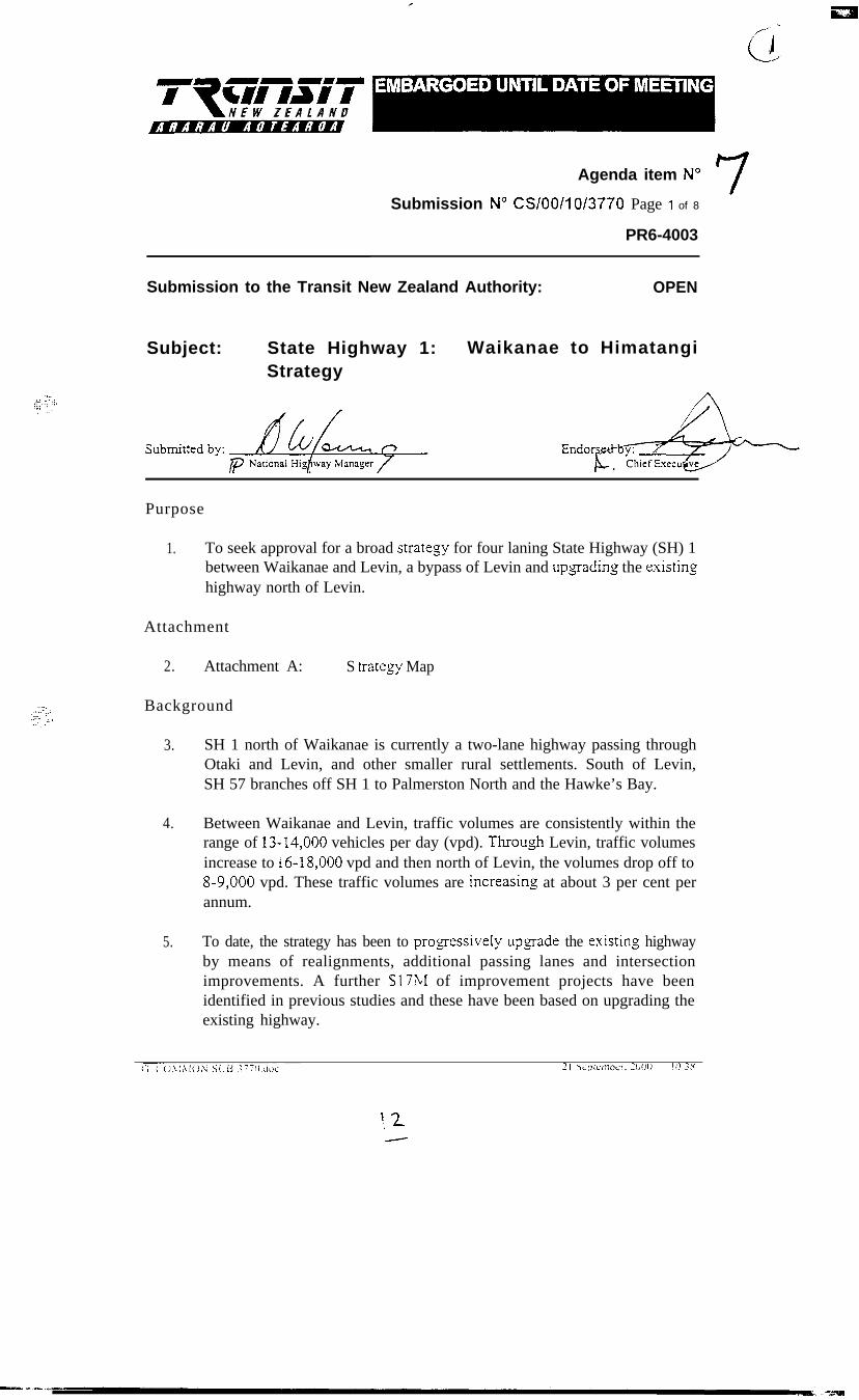
Agenda item N” 7Submission N” CS/OO/lO/3770 Page I of 8
PR6-4003
Submission to the Transit New Zealand Authority: OPEN
Subject: State Highway 1: Waikanae to HimatangiStrategy
Purpose
1. To seek approval for a broad strategy for four laning State Highway (SH) 1between Waikanae and Levin, a bypass of Levin and upgading the existinshighway north of Levin.
Attachment
2. Attachment A:
Background
S trate,oy Map
3. SH 1 north of Waikanae is currently a two-lane highway passing throughOtaki and Levin, and other smaller rural settlements. South of Levin,SH 57 branches off SH 1 to Palmerston North and the Hawke’s Bay.
4. Between Waikanae and Levin, traffic volumes are consistently within therange of 13-14,000 vehicles per day (vpd). Throu$r Levin, traffic volumesincrease to i6-18,000 vpd and then north of Levin, the volumes drop off to8-9,000 vpd. These traffic volumes are increasin,o at about 3 per cent perannum.
5. To date, the strategy has been to progessively upsade the existins highwayby means of realignments, additional passing lanes and intersectionimprovements. A further S17;Ll of improvement projects have beenidentified in previous studies and these have been based on upgrading theexisting highway.
‘. 2-

Page 2 of 8Submission CS/OO/10/3770
1
,
6. The practical capacity of a two lane rural highway in flat terrain is in therange of 16-15,000 vpd and traffic volumes between Waikanae and Levinare expected to reach this capacity within the next 5 to 10 years. InAustralia and North America, the thresholds for four laning are in the rangeof 8- 12,000 vpd.
7. Through Otaki and Levin, traffic volumes are expected to increase to over20,000 vpd within 10 years which will require the existing highway to bewidened or bypassed within this timeframe
8. It is now appropriate to plan for four lanin,0 the existing hi,ohway (or a newtwo or four lane highway) between Waikanae and Levin, and bypasses ofOtaki and Levin (or for widening the existing hishxvay). North of Levin, atwo lane highway will be adequate for the next 20 years and accordingly itis appropriate to retain a two lane highway with improvements as required.
Strategy Study
9. A study has been underway since 1998 to develop a broad strategy. Inparticular, the study has been to investigate the following options:
(a) Waikanae to Levin(9 a four lane expressway on or close to the existing highway
alignment, or(ii) a new two or four lane highway on a new coastal route.
(b) Levin Bypass(9 a bypass west of Levin, or(ii) a bypass east of Levin, or(iii) widening the existing highway through Levin.
(c) North of Levin(9 improvements to the existins two lane highway.
Waikanae to Levin
10. The forecast traffic volume on the corridor in 20 10 is 17,000 vpd, and of thisvolume, 9,500 would be attracted to a new coastal route. This would onlywarrant a hvo-lane highway, at least initially, and a four-lane highway ona new coastal route would only be justified in 30 - 50 years when the trafficvolume increased to at least 15,000 vpd.
11. Accordingly, the options are either for a pair of tn.o-lane highwayscomprising a new coastal highway and the existins hi,oh\vay, or a four-lanehighway on or close to the existing ali,onment. The comparative costs andbenefits of these options from north of Waikanae to Waitarere (including
i3.-
Page 3 of 8Submission CS/OO/10/3770
7,, <..%
-. __,;y
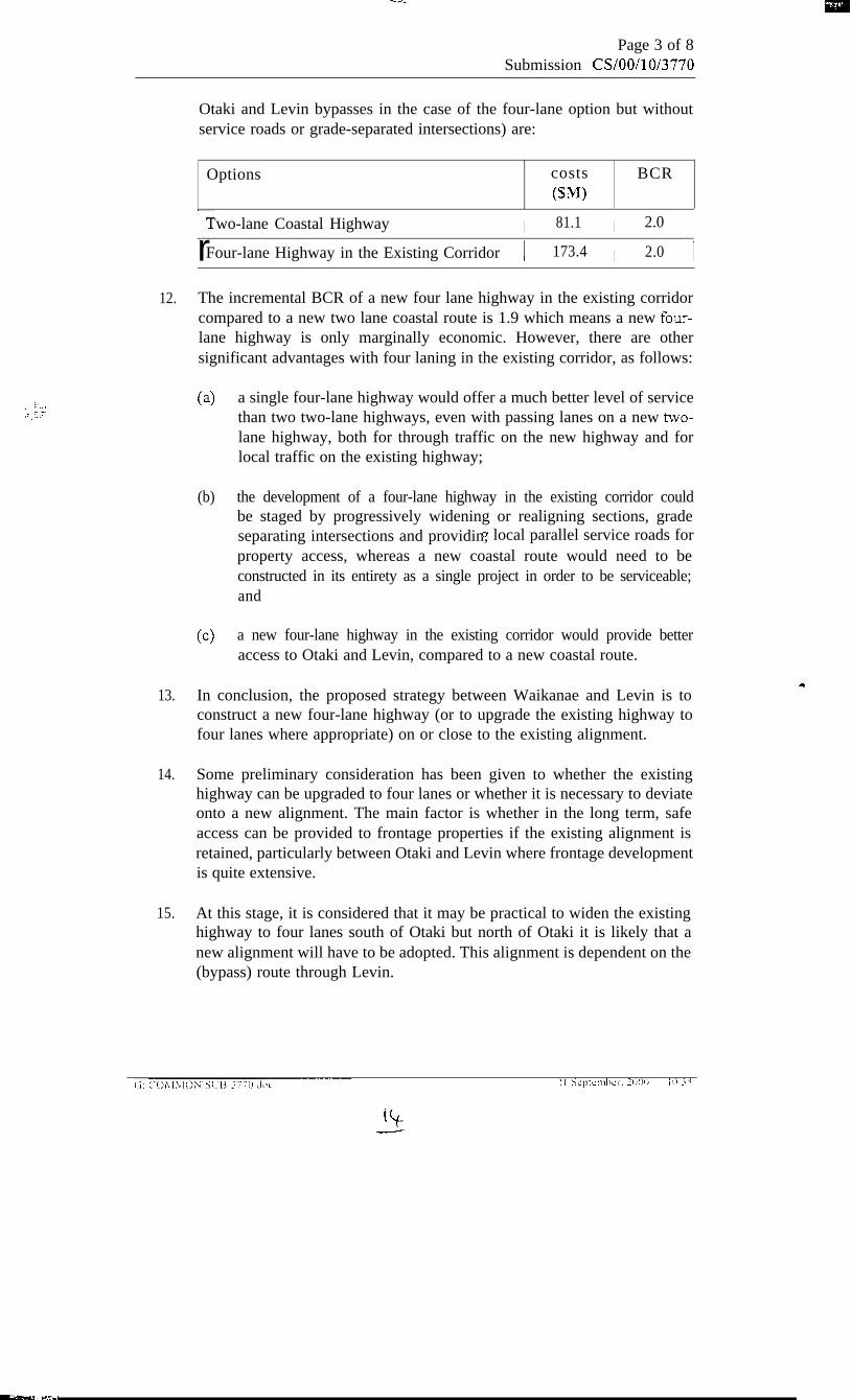
Otaki and Levin bypasses in the case of the four-lane option but withoutservice roads or grade-separated intersections) are:
Options costs BCRcw
r--Two-lane Coastal Highway I 81.1 I 2.0 I
rFour-lane Highway in the Existing Corridor 1 173.4 I 2.0 I
12. The incremental BCR of a new four lane highway in the existing corridorcompared to a new two lane coastal route is 1.9 which means a new four-lane highway is only marginally economic. However, there are othersignificant advantages with four laning in the existing corridor, as follows:
(a> a single four-lane highway would offer a much better level of servicethan two two-lane highways, even with passing lanes on a new two-lane highway, both for through traffic on the new highway and forlocal traffic on the existing highway;
(b) the development of a four-lane highway in the existing corridor couldbe staged by progressively widening or realigning sections, gradeseparating intersections and providin,0 local parallel service roads forproperty access, whereas a new coastal route would need to beconstructed in its entirety as a single project in order to be serviceable;and
cc> a new four-lane highway in the existing corridor would provide betteraccess to Otaki and Levin, compared to a new coastal route.
13. In conclusion, the proposed strategy between Waikanae and Levin is toconstruct a new four-lane highway (or to upgrade the existing highway tofour lanes where appropriate) on or close to the existing alignment.
14. Some preliminary consideration has been given to whether the existinghighway can be upgraded to four lanes or whether it is necessary to deviateonto a new alignment. The main factor is whether in the long term, safeaccess can be provided to frontage properties if the existing alignment isretained, particularly between Otaki and Levin where frontage developmentis quite extensive.
15. At this stage, it is considered that it may be practical to widen the existinghighway to four lanes south of Otaki but north of Otaki it is likely that anew alignment will have to be adopted. This alignment is dependent on the(bypass) route through Levin.
Page 3 of 8Submission CS/OO/10/3770
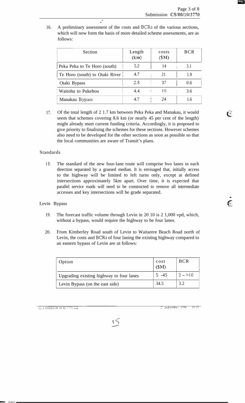
d‘16. A preliminary assessment of the costs and BCRs of the various sections,
which will now form the basis of more detailed scheme assessments, are asfollows:
Section Length costs BCR(km) (SM)
/ Peka Peka to Te Horo (south) 1 5.2 i 14 I 3.1 I
/ Te Horo (south) to Otaki River 1 4.7 I 21 I 1.8 I
Otaki Bypass
1 Waitohu to Pukehou
I 2.8 I 37 I 0.6 I
I 4.4 I 10 I 3.6 I
Manakau B,ypass 4.7 I 24 1.6
17. Of the total length of 2 1.7 km between Peka Peka and Manakau, it wouldseem that schemes covering 8.6 km (or nearly 45 per cent of the length)might already meet current funding criteria. Accordingly, it is proposed togive priority to finalising the schemes for these sections. However schemesalso need to be developed for the other sections as soon as possible so thatthe local communities are aware of Transit’s plans.
Standards
18. The standard of the new four-lane route will comprise hvo lanes in eachdirection separated by a grassed median. It is envisaged that, initially accessto the highway will be limited to left turns only, except at definedintersections approximately 5km apart. Over time, it is expected thatparallel service roads will need to be constructed to remove all intermediateaccesses and key intersections will be grade separated.
Levin Bypass
19. The forecast traffic volume through Levin in 20 10 is 2 1,000 vpd, which,without a bypass, would require the highway to be four lanes.
20. From Kimberley Road south of Levin to Waitarere Beach Road north ofLevin, the costs and BCRs of four laning the existing highway compared toan eastern bypass of Levin are a-s follows:
Option cos t BCR(SM)
Upgrading existing highway to four lanes
Levin Bypass (on the east side)
5 -45 2->lO
34.5 3.2

r:. .::.---,
Page 5 of SSubmission CS/OO/10/3770
21
22.
23.
24.
25.
The cost of upgrading ‘through’ Levin is dependent on accepted standards.For example, four lanes could be achieved by removing parking, taking outthe existing trees, banning turns at intersections and painting a doubleyellow line down the road centre-line. Alternatively the construction of acentral median with right turn bays and additional lanes at intersections forturning traffic and retaining angle parking would be more responsive to the“main street environment”, requiring the acquisition of commercialproperties.
On the basis that improvements would be required to preserve the “mainstreet” environment through Levin, the economics of upgrading the existinghighway and a bypass of Levin are comparable. However, the level ofservice through Levin would still be poor with the traffic flow beinginterrupted by two sets of signals. More importantly, however, four laningthe existing highway street of Levin would be very disruptive to the mainstreet, seriously aggravating the existing severance and problems throughthe retail and commercial area and destroying the existing streetscapeincluding the historic plane trees. The Horowhenua District Council (HDC)is opposed to any such disruption of the main street and instead supports abypass of Levin.
Three basic options for a bypass have been considered, hvo bypass optionsto the west of Levin, one on each side of Lake Horowhenua, and one bypassoption on the east side of Levin. Compared to the option of a bypassbetween Levin and Lake Horowhenua, a bypass west of Lake Horowhenuawould be more expensive, have less benefits and would have seriouscultural effects on local iwi sites. The entire area is considered to be waahitapu. This route is also not supported by HDC due to its remoteness fromLevin.
The costs and BCRs of bypass options between Lake Horowhenua andLevin, and east of Levin, are as follows:
Option Cost (SM) BCR
Bypass behveen Lake Horowhenua and Levin 43.2 1.8
Bypass east of Levin 34.8 3.2
A bypass east of Levin has a number of other significant advantages, asfollows:
(4 it provides a connection to SH 57, as well as SH 1 to the north, andtherefore is a better strategic option;
(b) it utilises part of the existing SH 57 al@ment, whereas a bypass westof Levin would cause significant property severances; and

Page 6 of SSubmission CS/OO/10/3770
I‘cc> a bypass behveen Lake Horowhenua and Levin would seriously
impact on recreational facilities at and around Lake Horowhenuawhere there are a number of parks.
26. Accordingly, a bypass east of Levin is preferred. With forecast trafficvolumes in 2010 of 9,000 vpd, it is envisaged that, initially, this will onlyneed to be two lanes. The preliminary BCR of this strategy is 3.2 based ona preliminary cost assessment of S34.8M.
27. It is possible that the southern leg connecting the proposed Manakau bypassand the existing section of SH 57 on Arapaepae Road serving SH 57 trafficonly could be justified in advance of the northern le,o traffic but this is anissue to be determined in the full scheme assessment.
28. Again, it is proposed to proceed now to a full scheme assessment to confirmthe route and obtain a designation. It is proposed that the designationshould be wide enough for ultimate four laning with gade separated
, interchanges and full access control.
North of Levin
29. As previously stated, a basic hvo-lane highway north of Levin will besufficient for the foreseeable future. Some improvements to the safety andefficiency of the existing highway are justified includin,o:
(a> seal widening to 10m;
(b) additional passing lanes; and
(4 reali,onment of the curves south of Foxton.
30. Some preliminary consideration has been given to the economics ofconstructing new passing lanes as sections of dual carriageway which couldultimately form part of a four-laning strategy (although it is expected thatfour laning will not be required for more than 20 years). A preliminaryassessment is that the extra costs of dual carriageways compared to normalpassing lanes may be justified by accident benefits.
31. The other issues which have been addressed on these sections is the need toultimately replace the Whirikino Trestle Brid,oe across the Motua Floodwayand whether there is a need ultimately for another bypass of Foxton. The1.2 km Whirokino Trestle Bridge is nearing the end of its economic life anda replacement bridge which would only need to be 600 m Ions would costSlO-12M. Such a replacement bridge could be constructed as part of a newbypass of Foxton.
32. Between Foston and the Whirokino Trestle Bridge, there are a couple ofsubstandard curves where there have been recent accidents. While thesecurves would be bypassed by any new Foxton bypass and replacementWhirokino Trestle Bridge. it is probably more economic to realign these

Page 7 of 8
YSubmission CS/OO/10/3770
-, :.:. ,:-
;f; -1:.:
curves now and defer any replacement of the Whirokino Trestle Bridge andconstruction of the Foxton Bypass.
33. However, this strate,oy needs to be confirmed by a more detailedinvestigation into the structural life of the Whirokino Trestle Bridge. Whenthis bridge was examined in 1997, its residual life was assessed to be nomore than about 10 years but this is now beins reviewed.
Implementation
34. There are likely to be components of the work proposed between Waikanaeand Levin, including sections of the Levin bypass that can be constructedin the near future. Consideration will need to be ,oiven, however, to animplementation strate,oy for the entire route. Further work is required tofinalise such an implementation strategy and to confirm the costs and BCRsof the various sections this would form a basis for developins such astrate,oy to facilitate the contiguous development of the route in its entirety.
Consultation
35. During the development of this broad strategy, consultation has taken placewith Tan,oata Whenua, all affected Territorial Authorities, Department ofConservation, NZ Archaeological Association, Historic Places Trust, TranzRail and Horowhenua commercial interests amongt others. The nature ofthe discussion has included meetings, newsletters, media spreads and thedistribution of information packa,oes to these parties. The consultation hadbeen re,oarded as ‘preliminary’, until such time as a preferred option isdeveloped.
36. A significant outcome from the consultations with HDC is its preference fora bypass to the east of Levin rather than having four lanes constructedthrough the main street or having a bypass to the west near LakeHorowhenua.
37. It is now proposed to publish the broad strate,oy of developing a four-lanehi,ohway in the existing corridor betJveen Waikanae (Peka Peka) and Levin,developing an eastern bypass of Levin, and retainins the existing two-lanehi,ohway north of Levin. This strategy u-ill be presented to the Kapiti CoastDistrict Council (KCDC) and HDC, the local community boards, and otherinterested parties. It will need to be emphasised that the detailed ali,onment,including whether the highway is to remain on the existing ali,onment or beshifted to a new alignment has not been determined for each section but,rather, is a matter for the detailed scheme assessment phase.
38. The outcome of this communication process will be reported back for theAuthority to confirm the strategy, as appropriate. The adopted strategy willthen form the basis of detailed scheme assessments of each section and forlodsing notices of requirement for designation Lvirh the KCDC and HDC.
A
\;i
.-

39. That the Authority:
(a>
(b)
Cc)
(4
notes the proposed strate,oy for State Highway 1 between Waikanaeand Himatan,oi comprising:
(9 a four lane highway in the existing corridor between Waikanae(Peka Peka) and Levin;
(ii) a hvo-lane eastern bypass of Levin;
(iii) retaining the existing two-lane highway north of Levin withimprovements including:
. seal widening
. additional passing lanes
. a short reali,gment south of Foxton;
notes that a four-lane highway between Waikanae and Levin is likelyto have some sections on the existing ali,grnent and some sections ofnew ali,gunent, which will be an issue to be resolved in schemeassessments;
agrees to publicise and present the proposed strategy to the KapitiCoast and Horowhenua District Councils, community boards andother interested parties and request the Chief Executive to report backon the results of this consultation process for the Authority to confirmthe strategy, as appropriate; and
notes that the proposed strategy will now form the basis of detailedscheme assessments of the various sections.
Page 8 of 8Submission CS/OO/10/3770
-. _-
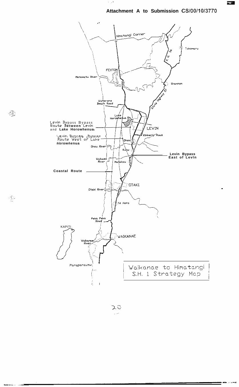
Attachment A to Submission CS/OO/l o/3770
b&Bir
p a s s B y p a s se t w e e n Levm
and Lake Horowhenua
I ovin R\,nn<c R\/nr\cc I
Levin BypassE a s t o f L e v l n
norownenua
Coastal Route
KAPITI
Paraparaumu:f....
[,
ii; I
1 Waikanae to Himatangi 1
I SH 1 Strategy MapI
Project Newsletter 1: November 2000
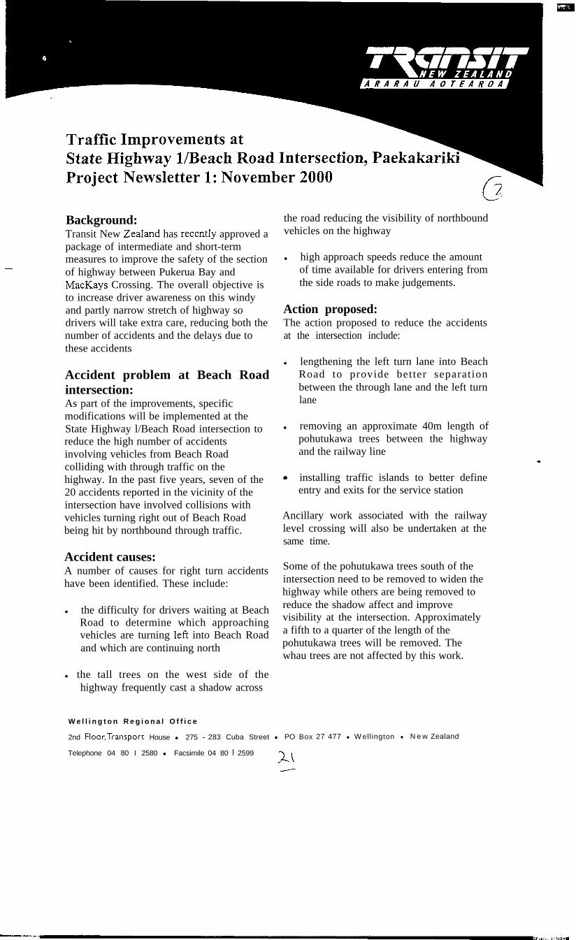
-
Background:Transit New ZeaIand has recentIy approved apackage of intermediate and short-termmeasures to improve the safety of the sectionof highway between Pukerua Bay andMa&Lays Crossing. The overall objective isto increase driver awareness on this windyand partly narrow stretch of highway sodrivers will take extra care, reducing both thenumber of accidents and the delays due tothese accidents
\L3
the road reducing the visibility of northboundvehicles on the highway
l high approach speeds reduce the amountof time available for drivers entering fromthe side roads to make judgements.
Action proposed:The action proposed to reduce the accidentsat the intersection include:
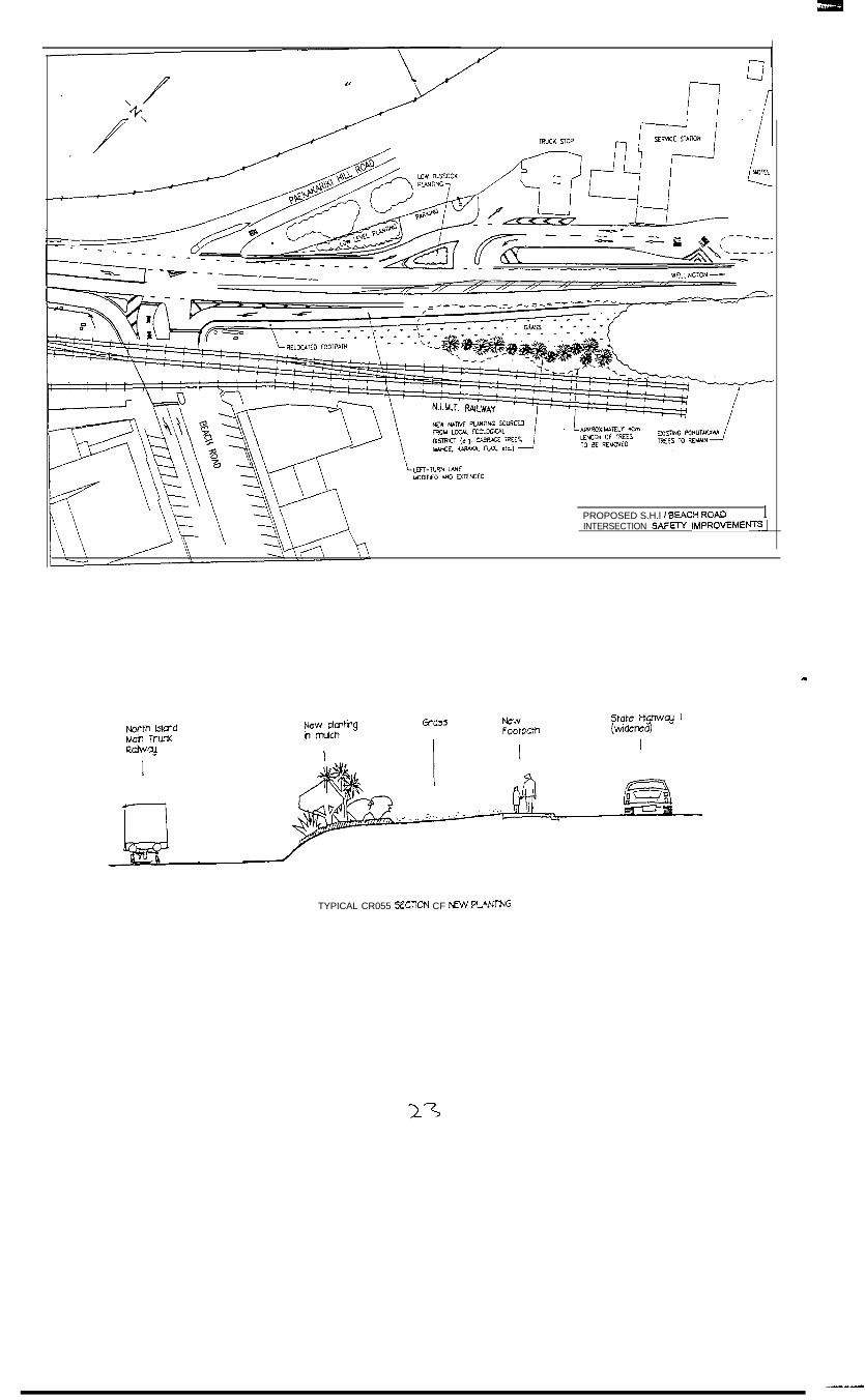
Accident problem at Beach Roadintersection:As part of the improvements, specificmodifications will be implemented at theState Highway l/Beach Road intersection toreduce the high number of accidentsinvolving vehicles from Beach Roadcolliding with through traffic on thehighway. In the past five years, seven of the20 accidents reported in the vicinity of theintersection have involved collisions withvehicles turning right out of Beach Roadbeing hit by northbound through traffic.
l lengthening the left turn lane into BeachRoad to provide better separationbetween the through lane and the left turnlane
l removing an approximate 40m length ofpohutukawa trees between the highwayand the railway line
-a
0 installing traffic islands to better defineentry and exits for the service station
Ancillary work associated with the railwaylevel crossing will also be undertaken at thesame time.
Accident causes:A number of causes for right turn accidentshave been identified. These include:
l the difficulty for drivers waiting at BeachRoad to determine which approachingvehicles are turning left into Beach Roadand which are continuing north
Some of the pohutukawa trees south of theintersection need to be removed to widen thehighway while others are being removed toreduce the shadow affect and improvevisibility at the intersection. Approximatelya fifth to a quarter of the length of thepohutukawa trees will be removed. Thewhau trees are not affected by this work.
l the tall trees on the west side of thehighway frequently cast a shadow across
W e l l i n g t o n R e g i o n a l O f f i c e
2nd Floor,Transport House l 275 - 283 Cuba Street l PO Box 27 477 l W ellington l N e w Zealand
Telephone 04 80 I 2580 l Facsimile 04 80 I 2599u-I
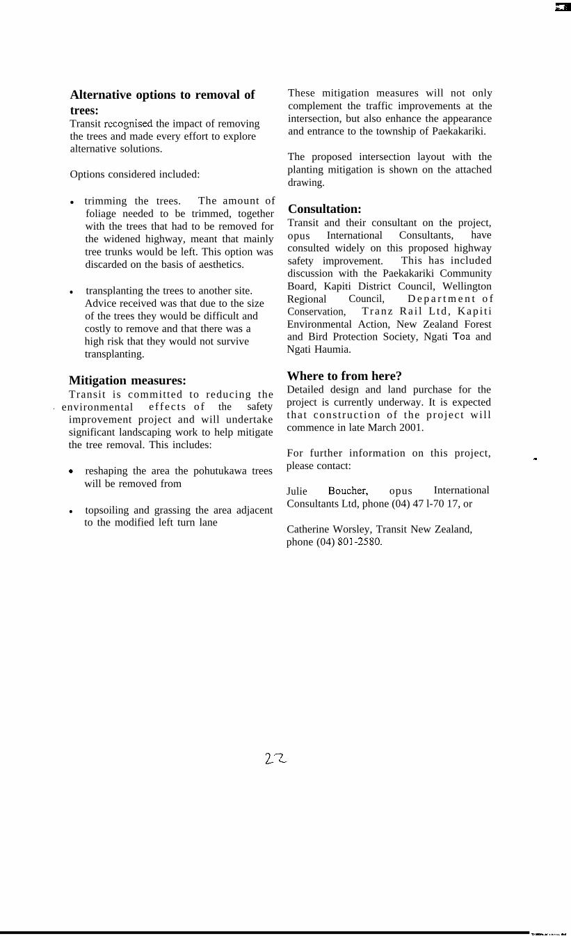
Alternative options to removal oftrees:Transit recognised the impact of removingthe trees and made every effort to explorealternative solutions.
Options considered included:
l trimming the trees. The amount offoliage needed to be trimmed, togetherwith the trees that had to be removed forthe widened highway, meant that mainlytree trunks would be left. This option wasdiscarded on the basis of aesthetics.
l transplanting the trees to another site.Advice received was that due to the sizeof the trees they would be difficult andcostly to remove and that there was ahigh risk that they would not survivetransplanting.
Mitigation measures:Transit is committed to reducing the
- environmental e f fec t s o f the safetyimprovement project and will undertakesignificant landscaping work to help mitigatethe tree removal. This includes:
0 reshaping the area the pohutukawa treeswill be removed from
l topsoiling and grassing the area adjacentto the modified left turn lane
These mitigation measures will not onlycomplement the traffic improvements at theintersection, but also enhance the appearanceand entrance to the township of Paekakariki.
The proposed intersection layout with theplanting mitigation is shown on the attacheddrawing.
Consultation:Transit and their consultant on the project,opus International Consultants, haveconsulted widely on this proposed highwaysafety improvement. This has includeddiscussion with the Paekakariki CommunityBoard, Kapiti District Council, WellingtonRegional Council, D e p a r t m e n t o fConservation, T ranz Ra i l L td , Kap i t iEnvironmental Action, New Zealand Forestand Bird Protection Society, Ngati Toa andNgati Haumia.
Where to from here?Detailed design and land purchase for theproject is currently underway. It is expectedthat cons t ruc t ion of the projec t wi l lcommence in late March 2001.
For further information on this project,please contact:
Julie Boucher, opus InternationalConsultants Ltd, phone (04) 47 l-70 17, or
Catherine Worsley, Transit New Zealand,phone (04) 801-2580.
-
1PROPOSED S.H.l I BEACH ROADINTERSECTION SAFRY IMPROVEMENTS~
TYPICAL CR055 SECTICN CF %ZW FUNT-NG
A package of immediate and short-term improvements to make SH 1 from Pukerua Bay toMackays Crossing safer was approved today by the Transit New Zealand Authority.
“Our goal is to make this stretch of road so conspicuous that people will immediatelyimprove their driving behaviour and we will see a drop in the crash rate,” says Transit’sWellington regional manager Dave Rendall.
The overall strategy is to increase driver awareness that this is a section of highway on whichdrivers must take extra care. Transit will also encourage the Police to focus on speeding drivers,as they have been a factor in crashes.
The Authority also supported further investigation of longer-term improvements.
“Transit believes both the immediate and longer-term actions outlined below will be a bigstep in addressing the problems of this stretch of highway until Transmission Gully is built,”says Mr Rendall.
Coastal Section: Pukerua Bay - PaekakarikiThe main deficiencies of this stretch of highway are poor sight distances due to the hill onone side and the seawall on the other, limited passing opportunities, and seal width which isbelow the desired minimum.
Analysis of crash data shows that the crash rate is approximately three-quarters of the NewZealand average but there is a higher proportion of serious accidents. There is also a higher rateof crashes in wet weather. A disproportionate number of crashes, 62 per cent, are in thesouthbound direction and there has been a concentration of accidents at the end of thesouthbound passing lane. Transit proposes to close this passing lane. The lane is some 220 metresshorter than the current desired standard.
Immediate improvements include:. close the existing southbound passing lanel install:
oversized “No Passing x-kms” signs on both northbound and southbound approaches withreinforcement signs on each side of Paekakariki“Accident Area” signs at either end of this section, northbound at Pukerua Bay andsouthbound south of Mackays Crossing, with reminder signs at Fisherman’s Table6km, 4km and lkm advance-warning signs of the next passing laneduplicate signs on both sides of the highway where appropriate, replace the 1 OOkm/h signswith new oversized de-restriction signs and review curve speed advisory signs, chevroncurve indicators, chevron sight and speed boards
W e l l i n g t o n R e g i o n a l O f f i c e
2nd Floor,Transport House l 275 - 283 Cuba Street l PO Box 27 477 l Wellington l New Zealand
Telephone 04 80 I 2580 l Facsimile 04 80 I 2599
2Y-

red reflector markers on the edge lines at half their normal spacing and replace those closeto the end of their reflective life
double-yellow no-overtaking vibra-lines from the northern limit of Pukerua Bay toMacKays Crossing, including the straight south of Fisherman’s Table
0 upgrade edge marker postsl paint the seawall to improve its reflection at nightl re-mark limit lines for vehicles exiting Fisherman’s Tablel liaise with the Police to promote higher levels of speed enforcement including installation
of fixed speed cameras to reduce higher speeds and also make mobile speed camera sitessafer and more accessible
l undertake further speed surveys “before” and “after” at various locations along thecoastal section.
These improvements will cost approximately $190,000 and work will begin immediately.
Another improvement to be implemented in the next two - six months involves installing stub-ends on the edge lines which encourage drivers to slow down. These are only being trialled inAustralia at the moment and have not yet been used in New Zealand. Right-turn bays will bebuilt at Fisherman’s Table and visibility improved by cutting back the bank to the north of theintersection.
Previous work on the coastal section has indicated that increasing the road width is limited byeconomic and environmental factors. Installation of a median barrier is not feasible due to thenarrow width of the road. The footpath would need to be replaced by a cycling/pedestrianshoulder or relocated to the seaward side of the wall.
Other proposals include: installing variable message signs and camera monitoring (ATMS), as inthe Ngauranga Gorge, installing smart stud lit centre line markers and other highway lighting toassist night driving, installation of no-stopping restrictions, and closing of some rest areas.
Beach Road intersection with SH 1This is a very busy stretch ofhighway with traffic volumes of approximately 23,000 vehicles perday (vpd) with side road volumes of about 1,500 vpd on Beach Road and 500 vpd on PaekakarikiHill Road.
Work to date on analysing the problems at this intersection has identified four principalproblems. They are: the risk of crashes, particularly involving traffic turning right out of BeachRoad, delays to traffic entering the state highway from the side roads, the close proximity of therailway line to the state highway, and the location of the access to the service station and moteljust south of the intersection.
The short-term improvements to the Beach Road/SH l/Paekakariki Hill Road intersection aredetailed below. These were decided upon after consulting with local groups such as the KapitiCoast District Council, the Paekakariki Community Board, Kapiti Environmental Action,local iwi, the BP service station owner and DoC, Trans Rail, and NZ Forest and Bird.
Visibility for vehicles turning right out of Beach Road onto the highway will be improved byrealigning the highway to separate straight through and left-turning traffic and the removal of40-50 metres of trees. There will also be some redefinition of the road for improved access toand from the service station (see plan).
2 5---
Other short-term improvements to be implemented include:l additional lighting to the south of the intersection to improve visibility at night over the full
sight distance of 200 metresl removal or relocation of the bus shelter to improve visibility to the north0 modifications to the approach from Beach Road to reduce the gradient for right-turn traffic
as much as possible to provide a level platform for vehicles waiting to turn right and soreduce the effect of the existing gradient on drivers’ ability to accelerate from a stationaryposition
l enhanced signage to be integrated with improved signage on the entire coastal section.
The work on these improvements will start in January and take about two - three months tocomplete.
Over the next two - six months further actions will include threshold treatments at Paekakariki tohighlight that you are entering a township area.
The cost of the above is estimated to be $225,000.
Longer-term solutions considered include: traffic signals, a roundabout, grade separation andalternative access to Paekakariki.
Both the traffic signals and roundabout options have been discarded for lack of space and safetyreasons. At this stage the grade separation of Beach Road only has a benefit cost ratio (BCR) of1.5, not sufficiently high to attract funding. There is, however, a range of options that could beinvestigated in more detail in a scheme assessment.
A further possibility is to provide an underpass at Ames Street so as to effectively grade separatethe right-turn exit from Paekakariki at the south end. This has a BCR of approximately 3.1 andso is potentially an economically viable project.
As the roads in Paekakariki township are the responsibility of the Kapiti Coast District Council,Transit will work with the KCDC in developing these latter proposals.
The Transit Authority also considered on Wednesday strategies for property acquisition andplanning consents that would allow for the early construction of Transmission Gully. Afterdiscussion with the parties directly affected, Transit will shortly release this information.
ENDS
For further information contact:
Dave Rendall: Tel 04 801 2580 or 025 907 960
Or
Deborah Willett Tel: 04 496 6653
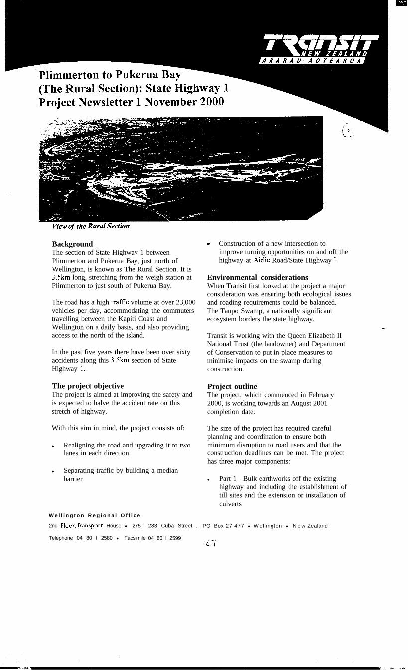
view of the Rural Section
BackgroundThe section of State Highway 1 betweenPlimmerton and Pukerua Bay, just north ofWellington, is known as The Rural Section. It is3Skm long, stretching from the weigh station atPlimmerton to just south of Pukerua Bay.
The road has a high traffic volume at over 23,000vehicles per day, accommodating the commuterstravelling between the Kapiti Coast andWellington on a daily basis, and also providingaccess to the north of the island.
In the past five years there have been over sixtyaccidents along this 3.5km section of StateHighway 1.
The project objectiveThe project is aimed at improving the safety andis expected to halve the accident rate on thisstretch of highway.
With this aim in mind, the project consists of:
l Realigning the road and upgrading it to twolanes in each direction
l Separating traffic by building a medianbarrier
0 Construction of a new intersection toimprove turning opportunities on and off thehighway at Airlie Road/State Highway 1
Environmental considerationsWhen Transit first looked at the project a majorconsideration was ensuring both ecological issuesand roading requirements could be balanced.The Taupo Swamp, a nationally significantecosystem borders the state highway.
Transit is working with the Queen Elizabeth IINational Trust (the landowner) and Departmentof Conservation to put in place measures tominimise impacts on the swamp duringconstruction.
Project outlineThe project, which commenced in February2000, is working towards an August 2001completion date.
The size of the project has required carefulplanning and coordination to ensure bothminimum disruption to road users and that theconstruction deadlines can be met. The projecthas three major components:
l Part 1 - Bulk earthworks off the existinghighway and including the establishment oftill sites and the extension or installation ofculverts
W e l l i n g t o n R e g i o n a l O f f i c e
2nd Floor,Transport House l 275 - 283 Cuba Street . PO Box 27 477 l W ellington l N e w Zealand
Telephone 04 80 I 2580 l Facsimile 04 80 I 25992-i
l Part 2 - Road construction involving’work onboth the new and existing road alignments,and including the installation of the medianbarrier. During this stage there will bedisruptions to traffic flow
l Part 3 - Landscaping and finishing workincluding roadmarking and new signs.
Part 1 -Bulk earthworks
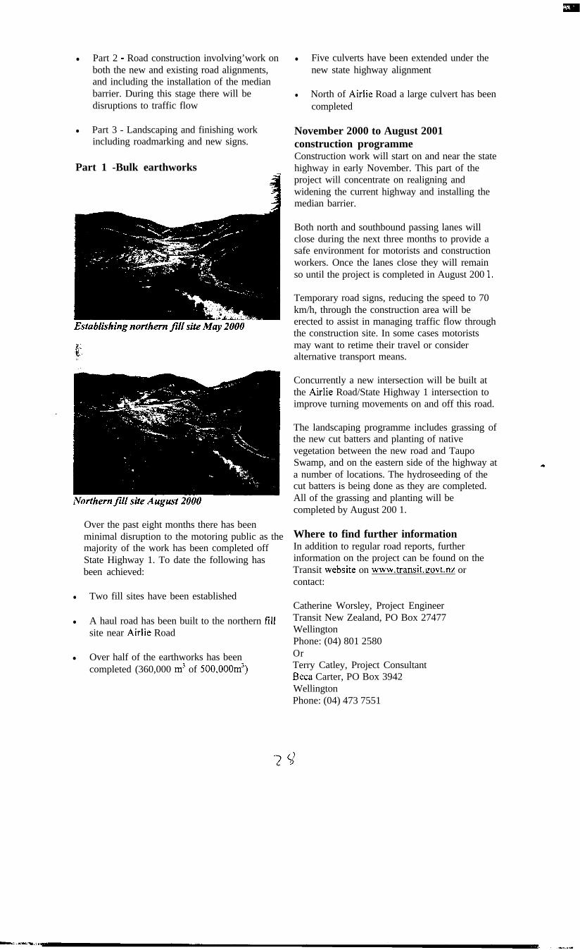
Establkhing northern fill site May 2000
Over the past eight months there has beenminimal disruption to the motoring public as themajority of the work has been completed offState Highway 1. To date the following hasbeen achieved:
l Two fill sites have been established
l A haul road has been built to the northern fillsite near Airlie Road
l Over half of the earthworks has beencompleted (360,000 m3 of 500,000m3)
l Five culverts have been extended under thenew state highway alignment
l North of Airlie Road a large culvert has beencompleted
November 2000 to August 2001construction programmeConstruction work will start on and near the statehighway in early November. This part of theproject will concentrate on realigning andwidening the current highway and installing themedian barrier.
Both north and southbound passing lanes willclose during the next three months to provide asafe environment for motorists and constructionworkers. Once the lanes close they will remainso until the project is completed in August 200 I.
Temporary road signs, reducing the speed to 70km/h, through the construction area will beerected to assist in managing traffic flow throughthe construction site. In some cases motoristsmay want to retime their travel or consideralternative transport means.
Concurrently a new intersection will be built atthe Airlie Road/State Highway 1 intersection toimprove turning movements on and off this road.
The landscaping programme includes grassing ofthe new cut batters and planting of nativevegetation between the new road and TaupoSwamp, and on the eastern side of the highway ata number of locations. The hydroseeding of thecut batters is being done as they are completed.All of the grassing and planting will becompleted by August 200 1.
Where to find further informationIn addition to regular road reports, furtherinformation on the project can be found on theTransit website on www.transit.govt.nz orcontact:
Catherine Worsley, Project EngineerTransit New Zealand, PO Box 27477WellingtonPhone: (04) 801 2580OrTerry Catley, Project ConsultantBeta Carter, PO Box 3942WellingtonPhone: (04) 473 7551
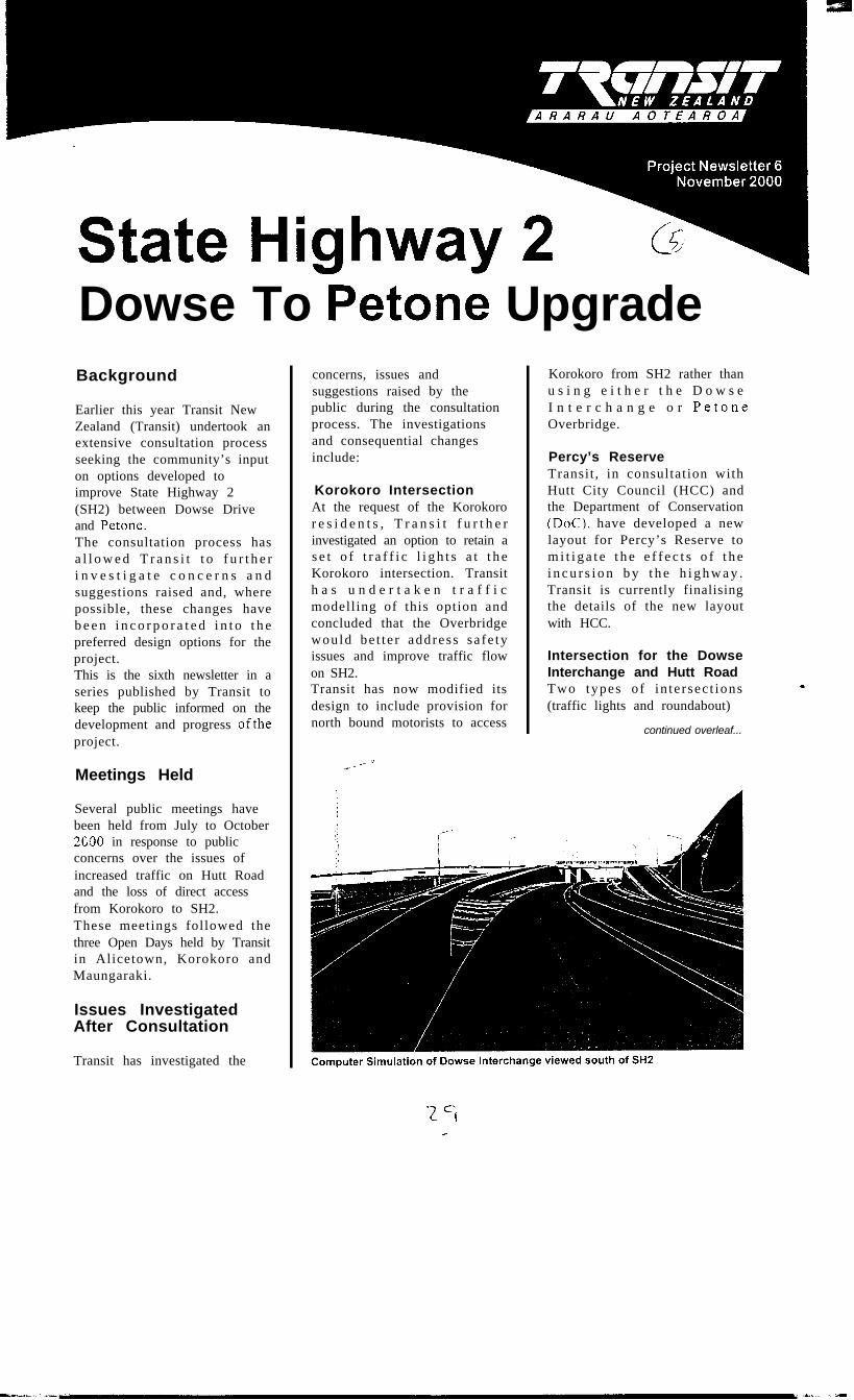
Dowse To Petone UpgradeBackground
Earlier this year Transit NewZealand (Transit) undertook anextensive consultation processseeking the community’s inputon options developed toimprove State Highway 2(SH2) between Dowse Driveand Petone.The consultation process hasa l l o w e d T r a n s i t t o f u r t h e ri n v e s t i g a t e c o n c e r n s a n dsuggestions raised and, wherepossible, these changes haveb e e n i n c o r p o r a t e d i n t o t h epreferred design options for theproject.This is the sixth newsletter in aseries published by Transit tokeep the public informed on thedevelopment and progress oftheproject.
Meetings Held
Several public meetings havebeen held from July to October2G90 in response to publicconcerns over the issues ofincreased traffic on Hutt Roadand the loss of direct accessfrom Korokoro to SH2.These meetings followed thethree Open Days held by Transitin Alicetown, Korokoro andMaungaraki.
Issues InvestigatedAfter Consultation
Transit has investigated the
concerns, issues andsuggestions raised by thepublic during the consultationprocess. The investigationsand consequential changesinclude:
Korokoro IntersectionAt the request of the Korokoror e s i d e n t s , T r a n s i t f u r t h e rinvestigated an option to retain as e t o f t r a f f i c l i g h t s a t t h eKorokoro intersection. Transith a s u n d e r t a k e n t r a f f i cmodelling of this option andconcluded that the Overbridgewould be t te r address sa fe tyissues and improve traffic flowon SH2.Transit has now modified itsdesign to include provision fornorth bound motorists to access
__, ‘f“_, _
Korokoro from SH2 rather thanu s i n g e i t h e r t h e D o w s eI n t e r c h a n g e o r PetoneOverbridge.
Percy’s ReserveTransit , in consultation withHutt City Council (HCC) andthe Department of Conservation(DoC), have developed a newlayout for Percy’s Reserve tom i t i g a t e t h e e f f e c t s o f t h ei n c u r s i o n b y t h e h i g h w a y .Transit is currently finalisingthe details of the new layoutwith HCC.
Intersection for the DowseInterchange and Hutt RoadTwo types of in te rsec t ions(traffic lights and roundabout)
continued overleaf...

for the Dowse Interchange/HuttR o a d i n t e r s e c t i o n w e r edisplayed at the previous OpenDays. The roundabout option isn o w p r e f e r r e d b e c a u s e i tprovides a freer flow for throught r a f f i c a n d b e t t e r p r o p e r t yaccess and parking along HuttRoad.
Petone R a i l w a y S t a t i o nParkand RideAccess to and from the PetoneRailway Station carpark wasidentified as a concern duringc o n s u l t a t i o n . T r a n s i t i nc o n s u l t a t i o n w i t h t h eWellington Regional Council(WRC) and Tranz Ra i l hasincorporated and extended an e w carpark l a y o u t i n t o i t sdesign and an additional carparkwes t o f SH2 wi th improvedaccess.
ProvisionsforCyclistsCycle groups suggested some
. modifications to the designsparticularly for the proposedD o w s e I n t e r c h a n g e . I nresponse to these suggestions,Transit has increased the widtho f t h e s h o u l d e r s o n t h eInterchange, the on/off rampsand on SH2 between Korokoroandpetone.
Cut Slope Near MagnoliaGroveConcerns were raised regardingthe proximity of the cut into thes l o p e a t D o w s e D r i v e t or e s i d e n t i a l p r o p e r t i e s i nMagnolia Grove. The designhas been modified to reduce thesize of the cut slope and movedthe top of the cuts away fromproperties on Magnolia Grove.
Concluding Open Days
The final design, incorporatingchanges, will be available for
t h e p u b l i c t o v i e w i n t w oc o n c l u d i n g O p e n D a y sschedu led fo r 25 November2000 (Saturday) at Hutt CentralSchool Hall, Railway Avenue,Lower Hutt between 2 - 6pm. Ont h e 2 8 N o v e m b e r 2 0 0 0(Tuesday) at George NicholsonH a l l , K o r o k o r o S c h o o l ,Korokoro, between 4 - 8pm.Staff from Transit, HCC andBeta will be available to discussthe project and the changesincorporated.
Project Web Site
Information on this project isa v a i l a b l e f o r v i e w i n g o nT r a n s i t ’ s w e b s i t e a t t h ef o l l o w i n g a d d r e s s :h t t p / w w w . transit.govt.nz.Selecting the sub title “Projects”allows access to the SH2 Dowseto Petone Upgrade web pages.
Future Programme
Transit anticipates lodging theresource consents applicationwith the consent authorities inearly March 200 1. The publicw i l l b e a b l e t o m a k e
Congestion at Korokoro
-pZ
submissions on the applicationsthat will be publicly notified atthat stage. The consent processi s expec ted to t ake severa lmonths to complete before finald e s i g n s a r e f i n a l i s e d a n dc o n s t r u c t i o n c o m m e n c e s .Trans i t an t i c ipa tes tha t thec o n s t r u c t i o n o f t h e D o w s eI n t e r c h a n g e a n d K o r o k o r oOverbridge will be undertakenbetween2002 and2004.
If you wish to receive copiesof the newsletter(s) or require
any further information, pleasecontact:
Steven Kerr or ChristineChong
Phone (04) 473 755 1Fax: (04) 496 2539
‘bBECA
PROJECT CONSULTANTS:Beta Carter Hollings & Ferner Ltd
190 Thorndon QuayPO Box 3942
WELLINGTON 4

StageEL, ,9.‘,,:$1 Blenhetm Upgrade projectto improve safety and trafficflow at several locations alongSHl through Blenheim hasbeen successfully completed.
The railway track betweenthe existing railway bridgeover the Taylor River andnorth of Dillons Point Roadwas relocated on scheduleand the new station platformis almost finished. Blenheim’shistoric railway station build-ing has been moved frombeside the state highway to
alongside the relocated trackand is currently being refur-bished by the MarlboroughDistrict Council.
Currently under construc-tion are three major round-abouts, a new bridge over theTaylor River and a new com-muter car park and bus parkat the station.
All three roundabouts areprogressing well - traffic hasbeen diverted to part of thenew Main Street roundabout.Bridge construction is alsowell underway with seven ofeight piles completed.
opened on 20 August
Work on the $4 million pro-ject started earlier this yearand is programmed to becompleted by April 2001.
One of three new roundabouts being constructed along StateHighway 1 as part of the Blenhelm Upgrade Project
The new bridge currently under constructionover the Taylor River
This year over 200,000 New Zealanders participated inremoving rubbish from highways, beaches, reserves and
communities in New Zealand’s biggest environmental clean up as partof Clean Up New Zealand week from 18-24 September.
Staff from the Wellington Regional Office assisted a Tasman DistrictCouncil initiative targeted at cleaning up Appleby Straight, SH60,Nelson and between Richmond and Wakefield on SH6, where theycollected four truckloads of rubbish. Other Wellington Regional Officestaff collected rubbish on SH2 in the Wairarapa and in Upper Hutt atMoonshine Bridge.
Kuru Love said it was great to be part of a community driven initiativeaimed at cleaning up the highways. lconttnued back pager
:s.: . . . --ca
TransitNew Zealand has formeda community based con-
sultation working group to assist in devel-oping long-term transport solutions aroundthe Basin Reserve.
The Basin Reserve is a unique part of Wellington.It combines an internationally recognised cricketground with a complex one way circulatory roadsystem. The roads function as a major hub ofurban ti,terial roads together with extensive localaccess.
While interim improvements were recentlycompleted there is a need to investigate long-termtransport solutions for the area. The project willconsider the strategy for the next 10 to 20 years.
Major areas to address include:G Improving interaction between arterial traffic
and local traffic/local accessG Congestion during peak periods0 Improving safety for cyclists, pedestrians and
vehiclesQ Safety of access to the Basin Reserve complex
and Mount VictoriaRod James, project manager, says it is essential
that any long-term solutions are developed with thesupport of the community and the local authority.
“We need a strategy that addresses safetyissues, traffic flow and access issues in the area. Acommunity consultative working group will be ableto provide valuable input on option developmentand evaluation.”
i%WatahNlUi’S BridgeReplacement project is one step closer withconstruction funding recently approved forthe $3 million project.
_ Pauatahanui Bridge is located approximately30km north of Wellington at a major intersection ofState Highway 58 with Paekakariki Hill Road.
It is the sole remaining single lane bridge on amajor arterial route in the Wellington region andcauses considerable delays when vehicles have toslow or stop to cross the bridge. It is also the siteof a high number of non-injury crashes.
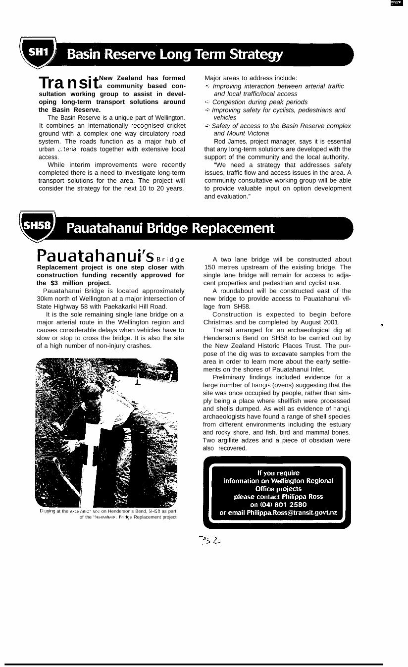
Dlgglng at the excavation site on Henderson’s Bend, SH58 as partof the Pauatahanul Bridge Replacement project
A two lane bridge will be constructed about150 metres upstream of the existing bridge. Thesingle lane bridge will remain for access to adja-cent properties and pedestrian and cyclist use.
A roundabout will be constructed east of thenew bridge to provide access to Pauatahanui vil-lage from SH58.
Construction is expected to begin beforeChristmas and be completed by August 2001.
Transit arranged for an archaeological dig atHenderson’s Bend on SH58 to be carried out bythe New Zealand Historic Places Trust. The pur-pose of the dig was to excavate samples from thearea in order to learn more about the early settle-ments on the shores of Pauatahanui Inlet.
Preliminary findings included evidence for alarge number of hangis (ovens) suggesting that thesite was once occupied by people, rather than sim-ply being a place where shellfish were processedand shells dumped. As well as evidence of hangi,archaeologists have found a range of shell speciesfrom different environments including the estuaryand rocky shore, and fish, bird and mammal bones.Two argillite adzes and a piece of obsidian werealso recovered.
_ ._ -. . ..- --...- Y.“,,Y
Ngauranga Gorge condltlons, mandatory speed srgns and lane availability signs Ml
“The amount of rubbish and debris continually dumped on the roads is a real concern. It can be hazardousto both road users and the environment,” he said. “While it was great to be part of the cleanup, the realmessage is to dispose of rubbish in the appropriate place, not on the road.”
Staff from Transit’sWellIngton RegIonal
Office and TasmanDistrict Council
partlclpate in CleanUp New Zealand
Week by plcklng uprubbish along SH6
near Nelson
)l r 1A DO.
1
Marice Jacksonhas been appointedas a project engineerin the WellingtonRegional Office. Shehas several years’experience in vari-ous areas of theroading industry.Marice has recently
shifted from Auckland where shewas employed as a project manag-er for Works Infrastructure withinthe surfacing department. She islooking after several projects,including those on the Rimutakaand Kaitoke Hills and also severalin the Blenheim area.
Mary Falconer hasbeen appointed as agraduate engineera f t e r r e c e n t l yc o m p l e t i n g herBE a t Can te rbu ryUniversity where shespecialised in hydraulicand geo techn i ca lengineering within
a wide range of engineeringdisciplines.
Mary is managing severalprojects, including SpoonersSummit upgrade (SH6) and theSH60 strategy study.
,
Gavin Gregg hasbeen seconded fromOPUS for six months tomanage several largeprojects including thePeka Peka HadfieldRoads intersection andthe structural bridgecontracts. Gavin hashad extensive experi-
ence in roading engineering, muchof it project work in theWellington/Nelson areas.
Plansfor construction of a new $1.5 millionrailway overbridge to the south of
the existing Elevation Overbridge have beenapproved.
Elevation Overbridge, approximately 2.5kmsouth of Picton on State Highway 1, has a poorsafety record and has been the scene of a numberof accidents in recent years.
The new overbridge has been designed toimprove safety for motorists. The width of the cur-rent bridge is inconsistent with the sealed width ofthe approaching roads. Furthermore, there are
two S bend alignments that require motorists tosignificantly reduce their speed to travel over thebridge.
A realignment of the current approaches willallow motorists to cross the new bridge at a speedof 90km/h, consistent with the surrounding envi-ronment
Designation and planning consents should belodged in the next couple of months.
-Work is soon to start on the realignmentof State Highway 6 between
Glenhope and Kawatiri, about 80km south ofNelson, after two years of investigation, planningand consultation.
The $6 million project aims to reduce the acci-dent problem on the 10km winding section ofhighway from the foot of Hope Saddle to KawatiriJunction.
Construction will include:- c3 Replacing the single lane Glenhope Bridge
with a two lane bridge
Q Widening two other bridges0 Creating north and south bound passing lanes
at the Glenhope end of the projectDesigned to complement the environment, the
realignment will generally follow the existing high-way and make use of the adjacent ex railwayreserve to minimise the impact on the KahurangiNational Park.
Transit has divided the project into three sec-tions to reduce the length of roadworks at any onetime in an effort to minimise disruption tomotorists.
S e v e n months into improving the3.5km rural section of State
Highway 1 between Pukerua Bay andPlimmerton, over half of the major earth workshave been completed.
Over 330,000 cubiemetres have now beenmoved and five culverts extended or installed.
When Transit first looked at the Plimmertonto Pukerua Bay project a major considerationwas ensuring both ecological issues and road-ing requirements could be balanced.
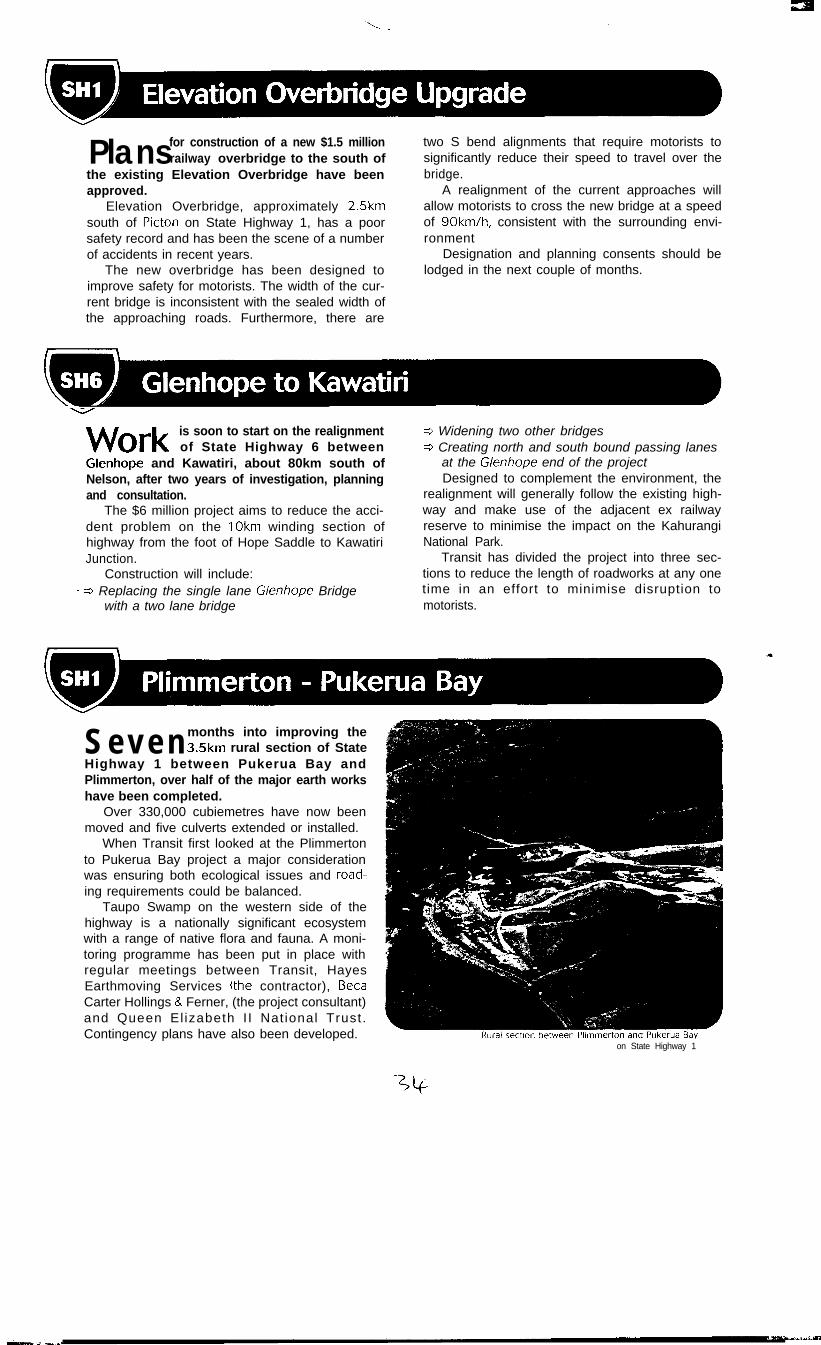
Taupo Swamp on the western side of thehighway is a nationally significant ecosystemwith a range of native flora and fauna. A moni-toring programme has been put in place withregular meetings between Transit, HayesEarthmoving Services (the contractor), BetaCarter Hollings & Ferner, (the project consultant)and Queen El izabeth I I Nat ional Trust.Contingency plans have also been developed.
on State Highway 1
10 October 2000
Wellington Regional CouncilP 0 Box 11646WELLINGTON
Attention: Tony Brennand
-Dear Sir
TRANSMISSION GULLY MOTORWAY
Further to the planning workshop held related to early construction of theTransmission Gully Motorway (TGM) in August, the Transit Authority resolved on 4October to proceed with all activities required to enable early construction of TGM.In particular the Authority resolved to:
l Commence property acquisition for all critical properties, and secure landrequired for advance mitigation works. Where appropriate, land required for theadvance mitigation works will be leased in order to secure the necessary land.
l Initiate further geotechnical and other investigations, together with preliminarydesign work to support the necessary remaining resource consent applications,and refine construction cost estimates; and
l Continue to consider the likely procurement strategy for the construction of theroute as the above actions proceed.
Transit will be seeking funding from Transfund for this additional activity as soon aspractical.
Project Programme
There are two likely programmes for the project. These are based on two options forthe engagement of the physical works contractor being conventional procurementwhich would be based on a “definitive” form of consents, and a design/refine/buildconcept based on “generic” consents. Both of these programmes assume allnecessary funding approvals and legislation will have been obtained by June 2002.The earliest completion date based on either conventional procurement or thealternative procurement delivery methods is the end of 2006, based on the key
W e l l i n g t o n R e g i o n a l O f f i c e
2nd Floor,Transport House 9 275 - 283 Cuba Street l PO Box 27 477 9 W ellington l N e w Zealand
Telephone 04 80 I 2580 l Facsimile 04 80 I 2599 35/
1
assumption that mitigation planting will only need to be in place for three years priorto commencement of earthworks.
This date makes no allowance for either compulsory land purchase or appeals againstthe resource consents. If compulsory purchase of land is required, the completiondate could be delayed until June 2007, and if there are appeals against resourceconsents, completion could be delayed until December 2008.
The programmes show a critical go/no go hold point for TGM as the date by whichlegislation needs to be passed, and funding confirmed for the “early” construction ofTGM. This hold point is currently programmed at mid 2002, but the feasibility ofwhether this date is achievable needs to be confirmed urgently by WRC.
Clearly, if a reduced period for mitigation planting of less than three years is agreed,there would be potential to advance the programme.
Closure
In summary, preliminary assessment indicates the earliest completion date of TGM tobe December 2006, assuming an immediate commencement of activities outlinedabove, and provided:
l There is early resolution of the Paremata Residents’ Association appealand the resolution of any subsequent appeals of resource consentdecisions;
l No compulsory land acquisition is needed, including mitigation areasrequired as conditions on the designation;
l Agreement to a three year mitigation retirement period (or less); and
l WRC securing the means of funding and all necessary legislation isconfirmed before mid 2002.
I will call shortly to discuss progress on our respective activities, and yourconfirmation that June 2002 is achievable in terms of securing the necessarycommitment to funding and passing of the required legislation.
Yours faithfully
D RendallREGIONAL MANAGER