Embed Size (px)
Citation preview
Grange Resources
Report for Cape Riche SeawaterDesalination Plant
Environmental Scoping 2011
June 2011
261/26005/106126 Cape Riche Seawater Desalination PlantEnvironmental Scoping Document Final (Revised June 2011)
Contents
1. Introduction 1
1.1 Background 1
1.2 Purpose of this Document 1
1.3 Proponent Details 2
1.4 Project Study Team 2
1.5 Project and Assessment Schedule 3
2. Summary Description of the Proposal 4
2.1 Project Overview 4
2.2 Project Location 4
2.3 Project Description 7
2.4 Project Justification 13
2.5 Alternatives Considered 14
3. Legislative Framework and Approvals 15
3.1 Applicable Guidelines and Standards 15
4. Environmental Setting 16
4.1 Land Use 16
4.2 Terrestrial Flora and Vegetation 16
4.3 Terrestrial Vertebrate Fauna 16
4.4 Coastal Environment 17
4.5 Marine Biodiversity 19
4.6 Marine Water Quality 21
4.7 Indigenous Heritage 21
4.8 Non-indigenous Heritage 22
4.9 Social 22
5. Potential Environmental Impacts and ManagementResponses 23
5.1 Marine Water Quality 23
5.2 Marine Biodiversity 24
5.3 Terrestrial Flora and Vegetation 24
5.4 Terrestrial Vertebrate Fauna 25
5.5 Surface Water 25
5.6 Indigenous Heritage 25
361/26005/106126 Cape Riche Seawater Desalination PlantEnvironmental Scoping Document Final (Revised June 2011)
5.7 Non-Indigenous Heritage 25
5.8 Ambient Air Quality 26
5.9 Greenhouse Gas Emissions 26
5.10 Noise and Vibration 26
5.11 Waste 27
5.12 Conservation Areas 27
5.13 Visual Amenity 28
5.14 Social Issues 28
6. Proposed Studies and Investigations 30
6.1 Terrestrial Flora and Fauna 30
6.2 Marine Habitat 30
6.3 Marine Fauna 31
6.4 Water Quality 32
6.5 Baseline Marine Data Collection 32
6.6 Hydrodynamic Modelling 33
6.7 Ecotoxicology 34
6.8 Hydrology 35
6.9 Air 35
6.10 Greenhouse Gas Emissions 36
6.11 Noise and Vibration 36
6.12 Waste 37
6.13 Social Impact Analysis 37
6.14 Indigenous Heritage 38
6.15 Landscape and Visual Impact Assessment 38
7. Commitments 39
8. Principles of Environmental Protection 41
9. Stakeholder Consultation and Communication 44
9.1 Stakeholder Consultation Plan 44
9.2 Stakeholders 45
10. Key Environmental Factors and Principles for thisProposal 47
11. References 54
461/26005/106126 Cape Riche Seawater Desalination PlantEnvironmental Scoping Document Final (Revised June 2011)
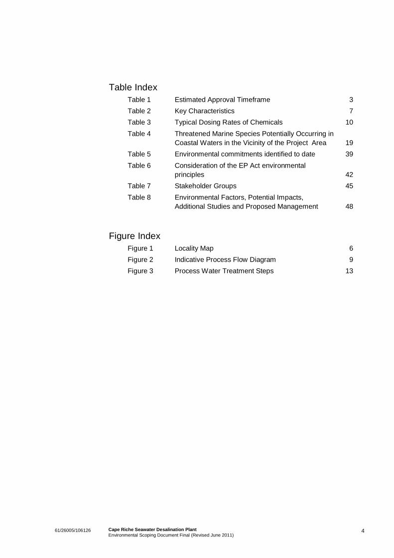
Table IndexTable 1 Estimated Approval Timeframe 3Table 2 Key Characteristics 7Table 3 Typical Dosing Rates of Chemicals 10Table 4 Threatened Marine Species Potentially Occurring in
Coastal Waters in the Vicinity of the Project Area 19Table 5 Environmental commitments identified to date 39Table 6 Consideration of the EP Act environmental
principles 42Table 7 Stakeholder Groups 45Table 8 Environmental Factors, Potential Impacts,
Additional Studies and Proposed Management 48
Figure IndexFigure 1 Locality Map 6Figure 2 Indicative Process Flow Diagram 9Figure 3 Process Water Treatment Steps 13
161/26005/106126 Cape Riche Seawater Desalination PlantEnvironmental Scoping Document Final (Revised June 2011)
1. Introduction
1.1 BackgroundGrange Resources Ltd (Grange) (the Proponent) is a leading magnetite producer and the onlycommercial producer of magnetite pellets in Australia, combining both mining and pellet productionexpertise. Grange has particular interest in developing the Southdown Magnetite project, which will seethem become one of the major suppliers of quality iron ore pellets in the region.
Grange received approval to construct and operate the Albany Iron Ore Project - Southdown Magnetiteproject on 24 November 2009 under Ministerial Statement 816. The Southdown Magnetite projectinvolves the construction and operation of an open pit magnetite mine located approximately90 kilometres (km) east north east of Albany, near Wellstead. The Southdown Magnetite project includespipelines for ore slurry and return water transport, construction of the mine site and port loading facilitiesat the Port of Albany.
The Southdown Magnetite mine site will require a reliable water source for such mining activities to occuralong the South Coast region of Western Australia. Grange proposes to develop a seawater desalinationplant to supply up to 12 Gigalitres per annum (GL/a) of water to the Southdown Magnetite mine site.
1.2 Purpose of this DocumentThe Cape Riche Seawater Desalination Project (the Project) was referred to the EnvironmentalProtection Authority (EPA) in January 2011 for assessment under s38 of the Environmental ProtectionAct (1986). The EPA has set the level of assessment for the Project at Public Environmental Review(PER) with a four week public review period.
The intention of the Environmental Scoping Document (ESD) is to assist the EPA in identifying the workrequired to ensure that all significant issues are properly considered as part of the EPA’s environmentalassessment of the proposal. Specifically this ESD has been prepared to:
Provide information on the potential impacts of the proposal and the proposed strategies to avoid,manage and mitigate these impacts;
Summarise the findings of environmental studies and investigations completed for the proposal todate; and
Outline the scope of additional studies or investigations required to further assess the environmentalimpacts of the proposal.
As listed in the Guide to Preparing an Environmental Scoping Document (EPA, 2009), other mattersincluding community consultation, peer review processes and key environmental principles are includedin this scoping document.
261/26005/106126 Cape Riche Seawater Desalination PlantEnvironmental Scoping Document Final (Revised June 2011)
1.3 Proponent DetailsThe Proponent for the Project is:
Company: Grange Resources Limited
Joint Venture Parties: Grange Resources Ltd (Grange) (70%), a company and Sojitz Resources &Technology Pty Ltd (30%). The Joint Venture is referred to as the SouthdownJoint Venture (SDJV)
Nominated contact: Julia Lawson
Position: Environmental Manager – Southdown Project
Address: c/- Level 11, 200 St Georges Terrace
Perth WA 6000
1.4 Project Study TeamA multi-discipline project team has been assembled to undertake the activities required to realise theProject. Experienced environmental practitioners are/will be providing advice to Grange Resources andundertaking the relevant environmental investigations.
1.4.1 Environmental Consultant Contact Details
Company: GHD Pty Ltd
Nominated Contact: Oliver Glade-Wright
Position: Senior Environmental Scientist
Address: 239 Adelaide Tce
Perth WA 6000
Phone: (08) 6222 8649
Fax: (08) 6222 8555
Email: [email protected]
361/26005/106126 Cape Riche Seawater Desalination PlantEnvironmental Scoping Document Final (Revised June 2011)
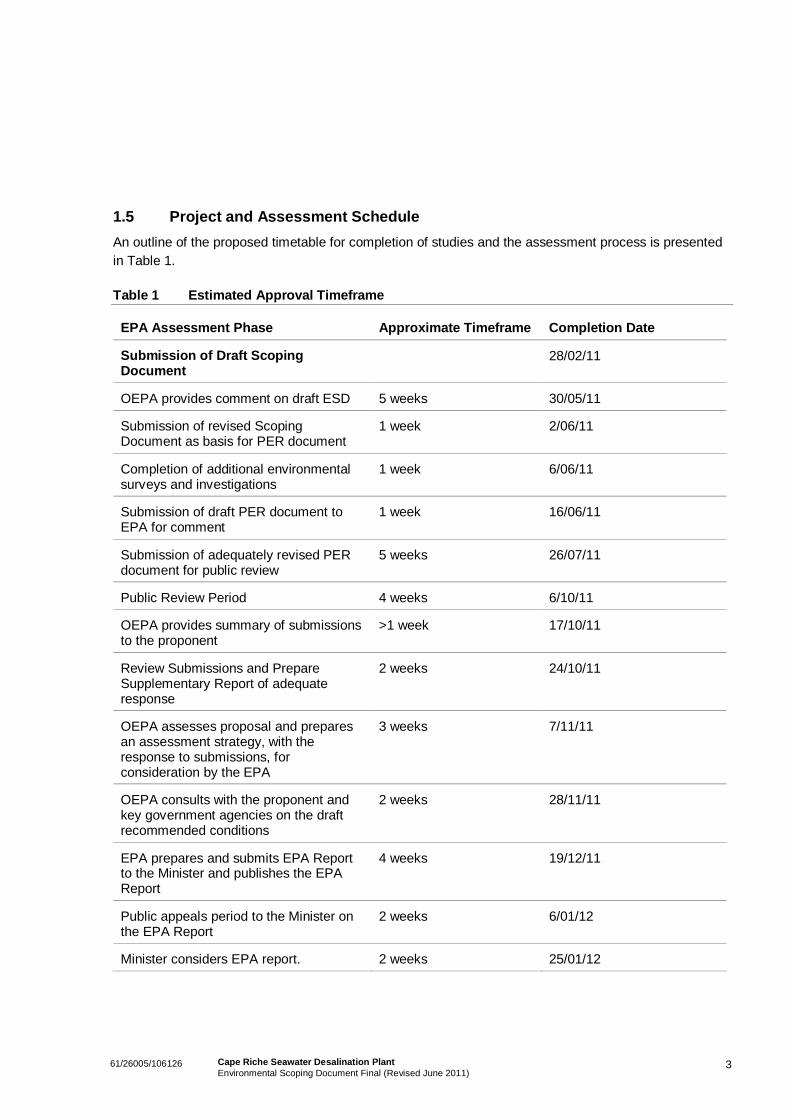
1.5 Project and Assessment ScheduleAn outline of the proposed timetable for completion of studies and the assessment process is presentedin Table 1.
Table 1 Estimated Approval Timeframe
EPA Assessment Phase Approximate Timeframe Completion Date
Submission of Draft ScopingDocument
28/02/11
OEPA provides comment on draft ESD 5 weeks 30/05/11
Submission of revised ScopingDocument as basis for PER document
1 week 2/06/11
Completion of additional environmentalsurveys and investigations
1 week 6/06/11
Submission of draft PER document toEPA for comment
1 week 16/06/11
Submission of adequately revised PERdocument for public review
5 weeks 26/07/11
Public Review Period 4 weeks 6/10/11
OEPA provides summary of submissionsto the proponent
>1 week 17/10/11
Review Submissions and PrepareSupplementary Report of adequateresponse
2 weeks 24/10/11
OEPA assesses proposal and preparesan assessment strategy, with theresponse to submissions, forconsideration by the EPA
3 weeks 7/11/11
OEPA consults with the proponent andkey government agencies on the draftrecommended conditions
2 weeks 28/11/11
EPA prepares and submits EPA Reportto the Minister and publishes the EPAReport
4 weeks 19/12/11
Public appeals period to the Minister onthe EPA Report
2 weeks 6/01/12
Minister considers EPA report. 2 weeks 25/01/12
461/26005/106126 Cape Riche Seawater Desalination PlantEnvironmental Scoping Document Final (Revised June 2011)
2. Summary Description of the Proposal
2.1 Project OverviewThe Cape Riche Seawater Desalination Plant Project is proposed by Grange to supplement in-situ watersupplies at the Southdown Magnetite mine site, for the purpose of transporting ore to processing andport facilities in Albany via the planned slurry pipeline. This Project involves supplying treated water tothe Southdown Magnetite mine site, via associated pipelines from the proposed Cape Riche SeawaterDesalination Plant.
The desalinated water will be used primarily as process water and for dust suppression at the mine site.A a small portion of the desalinated water will be further treated at the mine site to provide lower totaldissolve solids (TDS) water for the potable water supply. The proposed Cape Riche Desalination Plantwill be the major source of operational water supply for the processing plant, supplying over 85% ofmake-up water requirements. The proposed nominal capacity of the desalination plant will be 35 ML/day.
The Project is proposed to be constructed on freehold land 4.5 km east of Cape Riche, which is currentlyused for livestock and cropping agriculture.
The Project footprint includes the desalination plant, pump station, intake and discharge pipes, disposaland supply pipelines, and a treated water pipeline. Together they carry-out the following:
Seawater intake / outfall and pump station complete with upstream active screens;
Pre-treatment using Ultra filtration (UF) complete with pre-strainers;
Seawater Reverse Osmosis (SWRO) desalination complete with energy recovery;
Post-treatment consisting of re-mineralisation, pH correction and disinfection; and
Sludge thickening and dewatering using conventional thickeners and centrifuges.
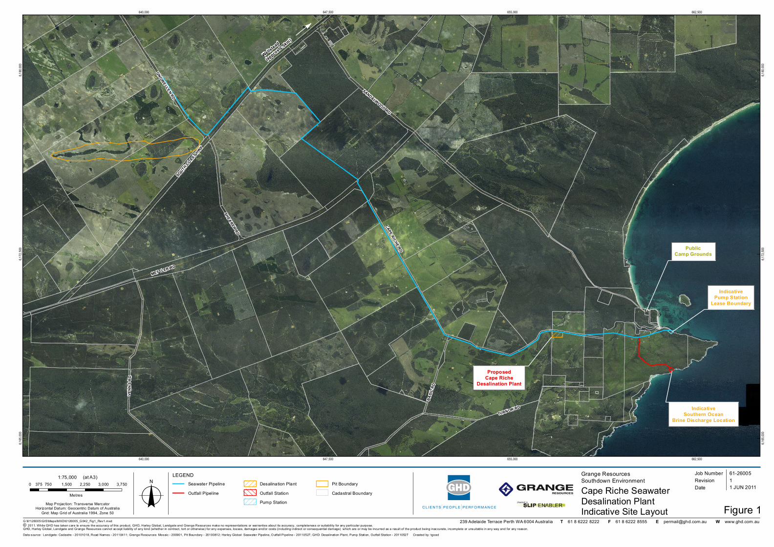
2.2 Project LocationThe proposed Cape Riche Seawater Desalination Plant proposed Project area is located in the southcoast region of Western Australia, approximately 100 km east of Albany and approximately 17 km south-west of Wellstead (Figure 1). The treated water will be transported via pipeline between the desalinationplant and the mine site.
The proposed location for the desalination plant is on cleared farming land approximately 4 km inlandfrom Cape Riche. The proposed desalination plant site is adjacent to Cape Riche Road and has beensuggested as a suitable site by the local landowner.
The proposed coastal pump station is located on the Cape Riche Homestead property, situated along thesouthern banks of the Cheyne Inlet and the Cape Riche coastline. Earlier consultation with the CapeRiche Homestead landowner has assisted in selecting the suitable site for the proposed below-groundpump station. The pump station site will be strategically positioned in consideration of the surroundingcoastal topography, minimising visual impacts upon the nearby Cape Riche Caravan Park and BoatHarbour.
The proposed pipeline corridors will consist of two sections, firstly transporting water between the coastalpump station and desalination plant, and secondly transporting treated water from the desalination plant

561/26005/106126 Cape Riche Seawater Desalination PlantEnvironmental Scoping Document Final (Revised June 2011)
to the mine site. Various infrastructure corridors traverse the Project area, with the entire proposedpipeline corridor extending across a total of 29 km. The pipelines will be located along existing clearedcorridors where available, subject to the approval of the relevant parties. The pipeline traverses an 800 msection of a proposed conservation park, however, will be located adjacent to an existing cleared corridor(Cape Riche Road). The proposed pipeline corridor alignment is shown in Figure 1.
METTLER RD
SANDALWOOD RD
CAPE RICHE RD
SOUTH COAST HWY
VENN
S RD
BASIL
RD
TURNOR RD
SHEARER RD
GNOWELLEN RD
640,000
640,000
647,500
647,500
655,000
655,000
662,500
662,500
6,165,
000
6,165,
000
6,172,
500
6,172,
500
6,180,
000
6,180,
000
Seawater PipelineOutfall Pipeline
Desalination PlantOutfall StationPump Station
Pit BoundaryCadastral Boundary
IndicativePump Station
Lease Boundary
ProposedCape Riche
Desalination Plant
PublicCamp Grounds
Wellstead
(approx 2.5km)
239 Adelaide Terrace Perth WA 6004 Australia T 61 8 6222 8222 F 61 8 6222 8555 E [email protected] W www.ghd.com.auG:\61\26005\GIS\Maps\MXD\6126005_G042_Fig1_Rev1.mxd© 2011. While GHD has taken care to ensure the accuracy of this product, GHD, Harley Global, Landgate and Grange Resources make no representations or warranties about its accuracy, completeness or suitability for any particular purpose. GHD, Harley G lobal, Landgate and Grange Resources cannot accept liability of any kind (whether in contract, tort or otherwise) for any expenses, losses, damages and/or costs (including indirect or consequential damage) which are or may be incurred as a result of the product being inaccurate, incomplete or unsuitable in any way and for any reason.
LEGEND0 750 1,500 2,250 3,000 3,750375
MetresMap Projection: Transverse Mercator
Horizontal Datum: Geocentric Datum of AustraliaGrid: Map Grid of Australia 1994, Zone 50
Cape Riche SeawaterDesalination PlantIndicative Site Layout Figure 1
Job NumberRevision 1
61-26005
1 JUN 2011o Date
Data source: Landgate: Cadastre - 20101018, Road Names - 20110411; Grange Resources: Mosaic - 200901, Pit Boundary - 20100812; Harley Global: Seawater Pipeline, Outfall Pipeline - 20110527; GHD: Desalination Plant, Pump Station, Outfall Station - 20110527 Created by: tgoad
1:75,000 (at A3) Grange ResourcesSouthdown Environment
DRAFT
IndicativeSouthern Ocean
Brine Discharge Location
761/26005/106126 Cape Riche Seawater Desalination PlantEnvironmental Scoping Document Final (Revised June 2011)
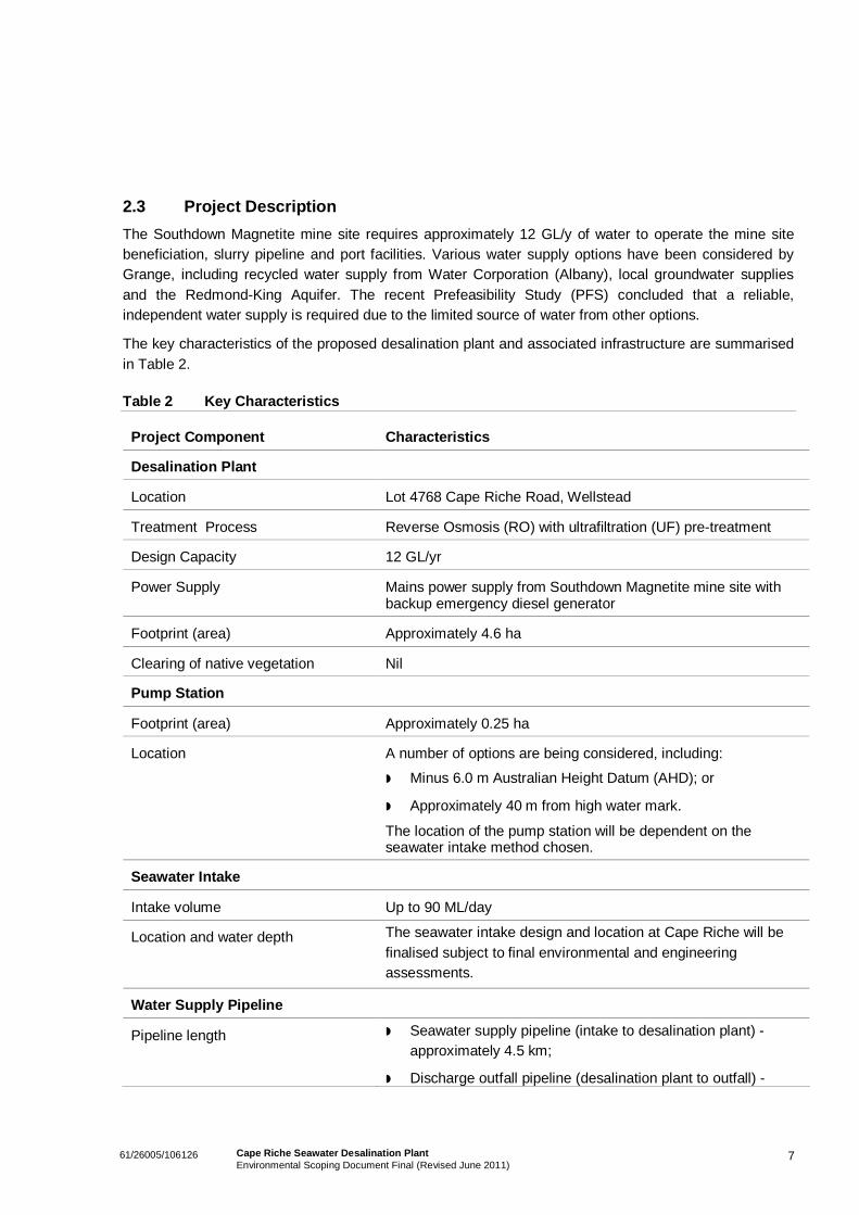
2.3 Project DescriptionThe Southdown Magnetite mine site requires approximately 12 GL/y of water to operate the mine sitebeneficiation, slurry pipeline and port facilities. Various water supply options have been considered byGrange, including recycled water supply from Water Corporation (Albany), local groundwater suppliesand the Redmond-King Aquifer. The recent Prefeasibility Study (PFS) concluded that a reliable,independent water supply is required due to the limited source of water from other options.
The key characteristics of the proposed desalination plant and associated infrastructure are summarisedin Table 2.
Table 2 Key Characteristics
Project Component Characteristics
Desalination Plant
Location Lot 4768 Cape Riche Road, Wellstead
Treatment Process Reverse Osmosis (RO) with ultrafiltration (UF) pre-treatment
Design Capacity 12 GL/yr
Power Supply Mains power supply from Southdown Magnetite mine site withbackup emergency diesel generator
Footprint (area) Approximately 4.6 ha
Clearing of native vegetation Nil
Pump Station
Footprint (area) Approximately 0.25 ha
Location A number of options are being considered, including:
Minus 6.0 m Australian Height Datum (AHD); or
Approximately 40 m from high water mark.
The location of the pump station will be dependent on theseawater intake method chosen.
Seawater Intake
Intake volume Up to 90 ML/day
Location and water depth The seawater intake design and location at Cape Riche will befinalised subject to final environmental and engineeringassessments.
Water Supply Pipeline
Pipeline length Seawater supply pipeline (intake to desalination plant) -approximately 4.5 km;
Discharge outfall pipeline (desalination plant to outfall) -
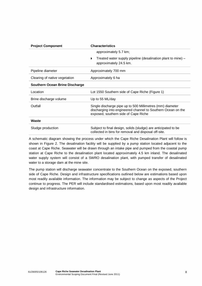
861/26005/106126 Cape Riche Seawater Desalination PlantEnvironmental Scoping Document Final (Revised June 2011)
Project Component Characteristics
approximately 5.7 km;
Treated water supply pipeline (desalination plant to mine) –approximately 24.5 km.
Pipeline diameter Approximately 700 mm
Clearing of native vegetation Approximately 6 ha
Southern Ocean Brine Discharge
Location Lot 1550 Southern side of Cape Riche (Figure 1)
Brine discharge volume Up to 55 ML/day
Outfall Single discharge pipe up to 500 Millimetres (mm) diameterdischarging into engineered channel to Southern Ocean on theexposed, southern side of Cape Riche
Waste
Sludge production Subject to final design, solids (sludge) are anticipated to becollected in bins for removal and disposal off-site.
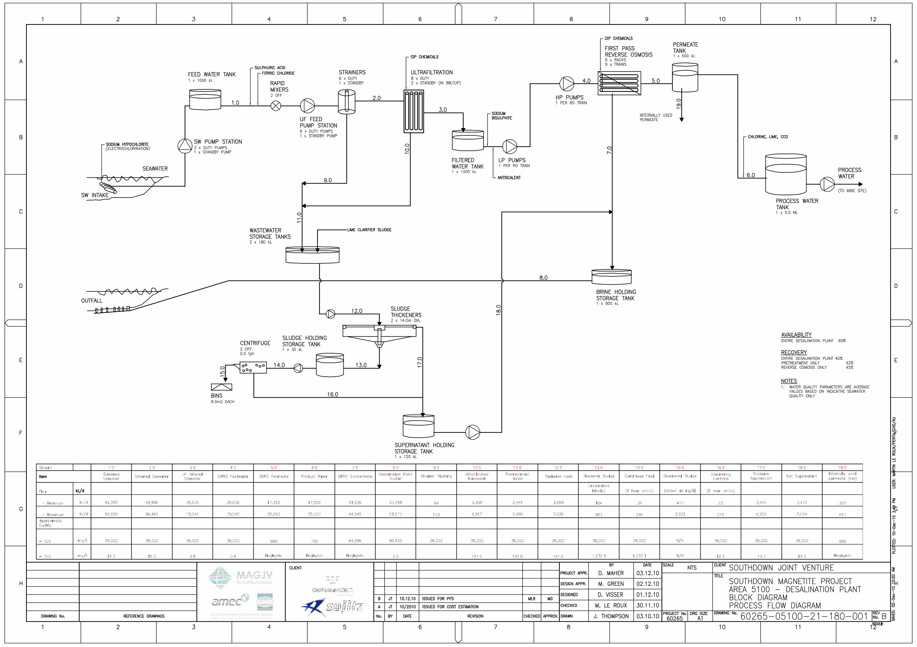
A schematic diagram showing the process under which the Cape Riche Desalination Plant will follow isshown in Figure 2. The desalination facility will be supplied by a pump station located adjacent to thecoast at Cape Riche. Seawater will be drawn through an intake pipe and pumped from the coastal pumpstation at Cape Riche to the desalination plant located approximately 4.5 km inland. The desalinatedwater supply system will consist of a SWRO desalination plant, with pumped transfer of desalinatedwater to a storage dam at the mine site.
The pump station will discharge seawater concentrate to the Southern Ocean on the exposed, southernside of Cape Riche. Design and infrastructure specifications outlined below are estimations based uponmost readily available information. The information may be subject to change as aspects of the Projectcontinue to progress. The PER will include standardised estimations, based upon most readily availabledesign and infrastructure information.
1061/26005/106126 Cape Riche Seawater Desalination PlantEnvironmental Scoping Document Final (Revised June 2011)
Desalination Plant
The desalination plant site is approximately 4.6 ha in area. Seawater extracted from the intakepump station will be stored in a 1,000 kL tank, having a 16 m internal diameter and providing atotal of 15 minutes of storage at maximum design flow. This tank will serve as control storagebetween the seawater pumping system and the desalination plant.
The desalination plant will consist of two main processes:
A UF pre-treatment plant to remove suspended solids from the seawater; and
An RO desalination plant to remove salt from the seawater.
Both the UF and RO plants will be configured as multiple trains to provide operational flexibilitywhile at the same time maintaining peak production. The RO plant will be a single pass design,i.e. the seawater will only pass through one set of membranes.
The desalination plant will have a nominal product water capacity of 35 ML/day. This willrequire approximately 90 ML/day of seawater to be brought into the desalination plant andapproximately 55 ML/day of seawater concentrate (brine) to be discharged back to the ocean.During certain times, governed by demand from the mine site, production rates will be lower,which will result in lower seawater inflow and brine discharge rates.
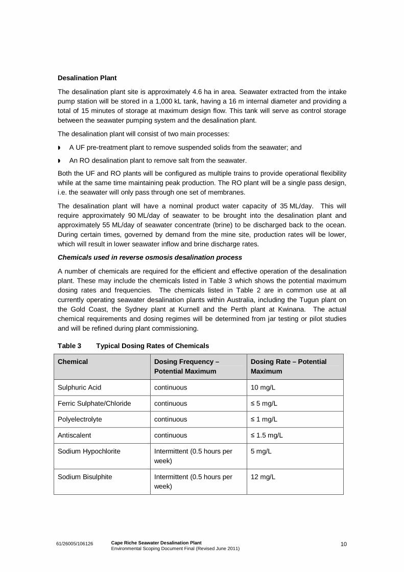
Chemicals used in reverse osmosis desalination process
A number of chemicals are required for the efficient and effective operation of the desalinationplant. These may include the chemicals listed in Table 3 which shows the potential maximumdosing rates and frequencies. The chemicals listed in Table 2 are in common use at allcurrently operating seawater desalination plants within Australia, including the Tugun plant onthe Gold Coast, the Sydney plant at Kurnell and the Perth plant at Kwinana. The actualchemical requirements and dosing regimes will be determined from jar testing or pilot studiesand will be refined during plant commissioning.
Table 3 Typical Dosing Rates of Chemicals
Chemical Dosing Frequency –Potential Maximum
Dosing Rate – PotentialMaximum
Sulphuric Acid continuous 10 mg/L
Ferric Sulphate/Chloride continuous 5 mg/L
Polyelectrolyte continuous 1 mg/L
Antiscalent continuous 1.5 mg/L
Sodium Hypochlorite Intermittent (0.5 hours perweek)
5 mg/L
Sodium Bisulphite Intermittent (0.5 hours perweek)
12 mg/L
1161/26005/106126 Cape Riche Seawater Desalination PlantEnvironmental Scoping Document Final (Revised June 2011)
Seawater Intake
The open channel seawater intake is located on the north side of Cape Riche peninsular about500 m west of the Cheyne Inlet. The intake is protected from the south west winter storms andfrom the north by Cheyne Island. The seawater intake design and location at Cape Riche aimsto minimise any potential social and environmental impacts within the surrounding area. Theproposed intake will consist of three main components:
An open channel structure to allow seawater to flow via gravity to the seawater pumpstation;
A below ground chamber with pumps located above the chamber to pump seawater fromthe intake to the desalination plant site; and
An electrical shed to house a 2.0 MVA substation.
Screening will be undertaken in the intake channel prior to water entering the seawater pumpingstation. This is to remove debris and large particulate matter prior to the water being deliveredto the desalination plant. Solids will be collected and disposed of at a licenced off-site facility
Brine DischargeWith the desalination plant having a recovery of 45%, approximately up to 55 ML/day, of brine(concentrated seawater) will be generated. Brine will be pumped to a storage tank prior to beingdischarged to the Southern Ocean via an outfall pipeline.
The brine outfall design and location at Cape Riche will aim to mitigate any potential social andenvironmental impacts within the surrounding area. In particular, the following environmentalfactors will be considered:
Water quality;
Size of the boundaries of the Low Ecological Protection Area (LEPA) and Zone of Effect;
Benthic habitat and ecology;
Seagrass and other BPP habitat;
Whales;
Penguins; and
Fish.
The outfall location will be strategically positioned to ensure that no significant environmentalimpacts will occur within the mixing zone. Investigations, including review of aerial photographs,vessel based surveys, marine investigations and discussion with local abalone divers, haveassisted in confirming the brine outfall location.
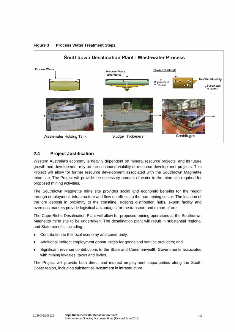
Wastewater
Wastewater will be collected in a wastewater holding tank, which will be used to buffer the flowsto the downstream treatment process (Figure 3). The tank will be mechanically agitated toprevent settlement. The mixed wastewater will be fed to circular sludge thickeners. The overflowwill be discharged to the seawater outfall while the underflow (sludge) will be sent to decantingcentrifuges to dewater the thickened sludge. Solids will be collected in bins for removal anddisposal offsite at a nearby waste facility.
1261/26005/106126 Cape Riche Seawater Desalination PlantEnvironmental Scoping Document Final (Revised June 2011)
Supply, Intake and Discharge Pipelines
The 4.5 km long intake and outfall pipeline route between the seawater pumping station and thedesalination plant follows existing cleared road corridors. The route undulates but generallyincreases in elevation from +10 m AHD at the pump station to +45 m AHD at the plant.
The pipeline route from the desalination plant to the mine site runs along Cape Road to the westthen to the northwest to the junction with Mettler Road, follows Mettler Road to the south west toShearer Road and follows the easement to the mine site. The route crosses the South CoastHighway at the South Coast Highway / Shearer Road intersection adjacent to the mine site. Theground level rises from approximately +48 m AHD at the desalination plant to approximately+135 m AHD at the mine site.
There is the possibility that the waste processing plant can be bypassed for substantial periodsof the year. During these periods the waste backwash water from the UF plant will bedischarged directly to the seawater concentrate outfall system without removal of solids. Theability to operate in this mode will depend on the seawater quality and the licence conditionssuggested for the Project under Part V of the Environmental Protection Act 1986.
Leak Detection
High-density polyethylene (HDPE) pipes and welds will be pressure tested for leaks prior toburial and commissioning, but will be subject to ongoing leak detection. Once buried routine‘pinhole’ leak detection is not practical. Major leaks will be detected through line pressure drops.The risk of leaks occurring is very low.
Pipe Cleaning
Chlorine if used will be neutralised prior to discharge through the marine outfall. Solids will becollected on the desalination plant site and trucked to a licenced landfill site. The discharge pipeis not expected to require cleaning as the concentration of brine will not promote marinegrowth. Generally inlet pipes will not require cleaning, but if required all chemicals added andsolids generated will be treated at the desalination plant site.
1361/26005/106126 Cape Riche Seawater Desalination PlantEnvironmental Scoping Document Final (Revised June 2011)
Figure 3 Process Water Treatment Steps
2.4 Project JustificationWestern Australia’s economy is heavily dependent on mineral resource projects, and its futuregrowth and development rely on the continued viability of resource development projects. ThisProject will allow for further resource development associated with the Southdown Magnetitemine site. The Project will provide the necessary amount of water to the mine site required forproposed mining activities.
The Southdown Magnetite mine site provides social and economic benefits for the regionthrough employment, infrastructure and flow-on effects to the non-mining sector. The location ofthe ore deposit in proximity to the coastline, existing distribution hubs, export facility andoverseas markets provide logistical advantages for the transport and export of ore.
The Cape Riche Desalination Plant will allow for proposed mining operations at the SouthdownMagnetite mine site to be undertaken. The desalination plant will result in substantial regionaland State benefits including:
Contribution to the local economy and community;
Additional indirect employment opportunities for goods and service providers; and
Significant revenue contributions to the State and Commonwealth Governments associatedwith mining loyalties, taxes and levies.
The Project will provide both direct and indirect employment opportunities along the SouthCoast region, including substantial investment in infrastructure.
1461/26005/106126 Cape Riche Seawater Desalination PlantEnvironmental Scoping Document Final (Revised June 2011)
2.5 Alternatives Considered
Alternative Desalination Site location
Community engagement within the lower south coast region was undertaken by the WaterCorporation in an effort to plan for new water sources in the area. Desalination was identified ashaving strong community support in the region, however, the Water Corporation suggested thatproposed seawater desalination plants will require additional investigation and consultation toidentify and select suitable sites along the coastline (Water Corporation, 2010).
Grange has researched a number of potential desalination plant sites along the Cape Richeregion, with the most suitable site located on cleared grazing land. Consultation with the locallandowner has assisted Grange in identifying the suitable site for the proposed desalinationplant.
A site closer to the coast could potentially be more economical, however, the proposed site is tohave the least impact upon:
Terrestrial environment;
Existing farming operations; and
Local residences.
Use of Existing Facilities
It is often assumed by the community that the Lower South Coast region experiences highrainfall and therefore water is abundant. However, in recent years the region has experiencedshortages in water for public supply. Some towns in the Lower Great Southern region areexperiencing potable water shortages, with existing water sources being fully used and, in somecases, temporarily overused (DoW, 2010a).
On top of this, the region’s projected economic and population growth is expected to furtherincrease demand for water, particularly for urban water supply and potentially for new industrialprojects (DoW, 2010a). The area has a limited number of known potential groundwater systemsand few river systems with water supply potential.
The Water Corporation is the main water supply provider of public water supplies for nearbytown of Wellstead. The existing water source for the town of Wellstead is a bitumen catchmentproviding a capacity of 8 megalitres per annum (ML/a). However, from 2003 to 2009 thisbitumen catchment did not receive over 2.31 ML/a, with 2008-09 only receiving 1.39 ML ofpotable water (DoW, 2010a). This existing water source is highly variable and limited in supplyvolume.
1561/26005/106126 Cape Riche Seawater Desalination PlantEnvironmental Scoping Document Final (Revised June 2011)
3. Legislative Framework and Approvals
The proposal is subject to the State and Commonwealth environmental legislation. They keypieces of State environmental legislation relevant to the proposal are:
Environmental Protection Act 1986 and associated regulations;
Aboriginal Heritage Act 1972; and
Wildlife Conservation Act 1950.
Grange referred the Project to the Environmental Protection Authority (EPA) for assessmentunder Section 38 (Part IV) of the Environmental Protection Act 1986 in January 2011. The levelof assessment was set as a PER with a four week public review period.
The Project will be referred to the Department of Sustainability, Environment, Water, Populationand Communities (SEWPaC).
3.1 Applicable Guidelines and StandardsThere are a number of State and Commonwealth policies, EPA position statements, EPAguidance statements, Codes of Practice and environmental guidelines that are applicable to theProject. The approval documentation will be undertaken in general accordance with theseguidelines and standards.
1661/26005/106126 Cape Riche Seawater Desalination PlantEnvironmental Scoping Document Final (Revised June 2011)
4. Environmental Setting
This section provides a brief description of the existing environment within which this proposedProject will be located. The information provided in this section is based on a desktopassessment and the findings of environmental studies and assessments completed for theProject area and other developments in the region.
4.1 Land UseCurrent land use for the proposed seawater desalination plant site and associated infrastructureis agriculture, predominantly grazing lands (Figure 1). Four dwellings exist in the vicinity of theplant. A camping ground is situated on the coast approximately 4 km’s to the east of theproposed intake pump station.
A number of minor road reserves exist in the area including along the proposed pipelineeasement.
Land use along the proposed pipeline easement is agricultural land.
The project area is located on freehold land as viewed on the Department of Water (DoW):Geographic Data Atlas (2010b). The proposed pipeline corridor route will follow existing clearedroad corridors. The pipeline traverses an 800 m section of a proposed Conservation Park, alongan existing cleared transport corridor. The pipeline corridor also runs alongside two areas whichare held as Crown Reserve (nature reserves), however, does not enter the Reserves.
4.2 Terrestrial Flora and VegetationThe majority of the Project footprint has been cleared of native vegetation for farming purposes.The construction of the treated water pipeline will require the clearing of a total of approximately6 ha of remnant vegetation.
The variation and composition of vegetation within the area is influenced largely by the variabledepth of leached white/grey sands. The flora of the Cape Riche region is described as diverseand significantly endemically localised in nature. Eucalypts dominate most systems in anunparalleled array of diversity (Comer, Gilfillan, Grant, Barrett and Anderson, 2001).
4.3 Terrestrial Vertebrate FaunaA vertebrate fauna assessment for the proposed Project area was undertaken by GHD inDecember 2010. The assessment included:
A reconnaissance survey was undertaken in conjunction with the botanical survey by aqualified zoologist, with regards to the Terrestrial Fauna Surveys for Environmental ImpactAssessment in Western Australia in Western Australia – EPA Guidance Statement No. 56,where possible; and
Opportunistic records of species were noted and an assessment of the likelihood of thepresences of significant fauna, fauna habitat values, and fauna linkage corridors at thesurvey area was undertaken.
1761/26005/106126 Cape Riche Seawater Desalination PlantEnvironmental Scoping Document Final (Revised June 2011)
No listed threatened species or Priority fauna were recorded during the surveys.
A final report compiling the results of the 2010 surveys will be included in the PER.
Cheyne Island
Islands off the southern coast provide important refuges for terrestrial animals including birds,mammals, reptiles, insects and molluscs, many of which are threatened by introduced predatorson the mainland (DEC, 2010).
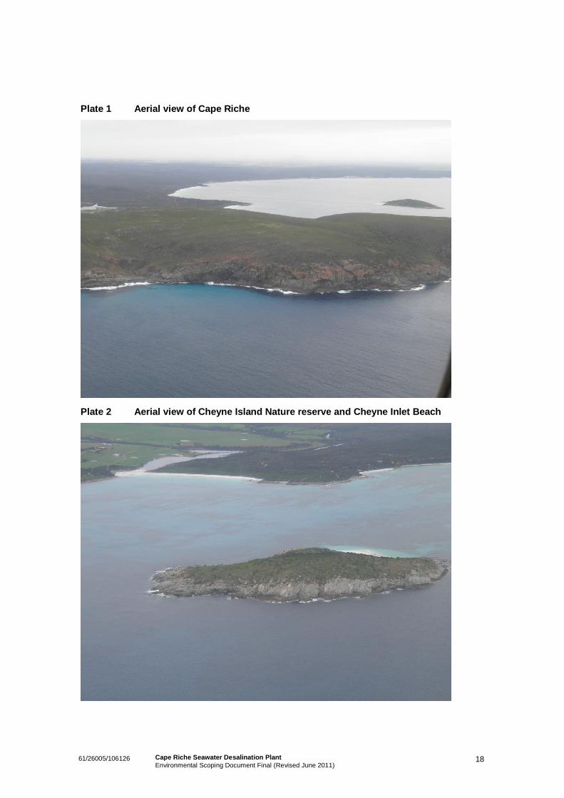
Cheyne Island Nature Reserve is situated in Cheyne Bay, approximately 1,200 m off thecoastline. It is one of very few islands in the area that has an accessible sandy beach forlanding and is within very easy boating distance of Cape Riche. There is a colony of LittlePenguins (Eudyptula minor) on the island.
4.4 Coastal EnvironmentThe South Coast marine region comprises over 1.75 million hectares of State waters andcovers some 2,600 km’s of coastline (DEC, 2010). The coast and waters of the South Coastregion cover the area from Augusta to the South Australian border. The coastal environmentaround the proposed desalination plant is characterised by a series of capes and bays with apredominantly east or south-easterly aspect.
The main factors influencing the hydrodynamics along the coastline of this region are wind, tide,waves, solar radiation, large scale currents such as the Leeuwin Current and, further away fromthe coast, the Antarctic Circumpolar Current (Colman, 1998).
The Leeuwin Current rounds Cape Leeuwin and flows eastwards towards south-easternAustralia after the summer months bringing warmer waters from the north. This current iscomparatively shallow and transports warm tropical water southward along the continental shelf,and east, all the way across to the North-West Cape of Tasmania. The Leeuwin Currentgenerally flows as a narrow band along the south coast, occasionally breaking off into largeoffshoots and eddies (Colman, 1998).
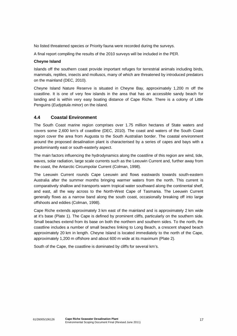
Cape Riche extends approximately 3 km east of the mainland and is approximately 2 km wideat it’s base (Plate 1). The Cape is defined by prominent cliffs, particularly on the southern side.Small beaches extend from its base on both the northern and southern sides. To the north, thecoastline includes a number of small beaches linking to Long Beach, a crescent shaped beachapproximately 20 km in length. Cheyne Island is located immediately to the north of the Cape,approximately 1,200 m offshore and about 600 m wide at its maximum (Plate 2).
South of the Cape, the coastline is dominated by cliffs for several km’s.
1861/26005/106126 Cape Riche Seawater Desalination PlantEnvironmental Scoping Document Final (Revised June 2011)
Plate 1 Aerial view of Cape Riche
Plate 2 Aerial view of Cheyne Island Nature reserve and Cheyne Inlet Beach
1961/26005/106126 Cape Riche Seawater Desalination PlantEnvironmental Scoping Document Final (Revised June 2011)
4.5 Marine BiodiversityThe South Coast marine environment is a region of high biodiversity, including granite reefs,limestone reefs, seagrass meadows, kelp gardens, sponge gardens, sand habitats and richcommunities of filter feeders in deeper waters (DEC, 2010).
The marine habitat of the Cheyne Bay area adjacent to Cape Riche was investigated during arecent (February 2011) survey for the proposed Project by GHD. The bay was found to bedominated by sandy substrate with large distinct areas of seagrass throughout the bay.
Seagrass species from the genus Posidonia and Amphibolis dominated the seagrass beds.
A small outcrop of plate coral was a notable discovery on the northern side of Cape Riche whichwas contained within an area of approximately 400m2. This outcrop will be considered alongwith seagrass when assessing potential discharge impacts and mitigation on benthic primaryproducers (BPPs).
Opportunistic fauna sightings, report reviews (Colman 1998, DEC 2010a, DEC 2010b) anddiscussions with local residents and fishermen indicate the following species are, or are likelyto, occur within the general area from time to time:
Seals (observed in vicinity during 2011 survey);
Whales; and
Little penguins.
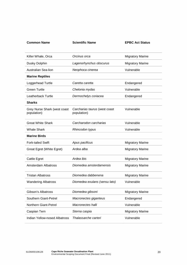
In addition, the Department of Sustainability, Environment, Water, Population and Communities(SEWPaC) Environmental Reporting Tool indicates that a number of listed marine speciesprotected under the Environment Protection and Biodiversity Act 1999 occur within marinewaters off the coast of Cape Riche. These are listed in Table 4.
Table 4 Threatened Marine Species Potentially Occurring in Coastal Waters in theVicinity of the Project Area
Common Name Scientific Name EPBC Act Status
Marine Mammals
Bryde’s Whale Balaenoptera edeni Migratory Marine
Blue Whale Balaenoptera musculus Endangered
Pygmy Right Whale Caperea marginata Migratory Marine
Southern Right Whale Eubalaena australis Endangered
Humpback Whale Megaptera novaeangliae Vulnerable
2061/26005/106126 Cape Riche Seawater Desalination PlantEnvironmental Scoping Document Final (Revised June 2011)
Common Name Scientific Name EPBC Act Status
Killer Whale, Orca Orcinus orca Migratory Marine
Dusky Dolphin Lagenorhynchus obscurus Migratory Marine
Australian Sea-lion Neophoca cinerea Vulnerable
Marine Reptiles
Loggerhead Turtle Caretta caretta Endangered
Green Turtle Chelonia mydas Vulnerable
Leatherback Turtle Dermochelys coriacea Endangered
Sharks
Grey Nurse Shark (west coastpopulation)
Carcharias taurus (west coastpopulation)
Vulnerable
Great White Shark Carcharodon carcharias Vulnerable
Whale Shark Rhincodon typus Vulnerable
Marine Birds
Fork-tailed Swift Apus pacificus Migratory Marine
Great Egret (White Egret) Ardea alba Migratory Marine
Cattle Egret Ardea ibis Migratory Marine
Amsterdam Albatross Diomedea amsterdamensis Migratory Marine
Tristan Albatross Diomedea dabbenena Migratory Marine
Wandering Albatross Diomedea exulans (sensu lato) Vulnerable
Gibson’s Albatross Diomedea gibsoni Migratory Marine
Southern Giant-Petrel Macronectes giganteus Endangered
Northern Giant-Petrel Macronectes halli Vulnerable
Caspian Tern Sterna caspia Migratory Marine
Indian Yellow-nosed Albatross Thalassarche carteri Vulnerable
2161/26005/106126 Cape Riche Seawater Desalination PlantEnvironmental Scoping Document Final (Revised June 2011)
Common Name Scientific Name EPBC Act Status
Shy Albatross Thalassarche cauta (sensu stricto) Migratory Marine
Yellow-nosed Albatross Thalassarche chlororhynchos Migratory Marine
Black-browed Albatross Thalassarche melanophris Vulnerable
4.6 Marine Water QualityThe local marine water quality is greatly influenced by the lack of river discharge into the region.The few significant rivers adjacent to the region flow intermittently and their overall dischargeare low. Consequently, there is a limited amount of nutrient inputs. When combined with thesuppression of large-scale upwelling experienced in this part of the coast, the limited nutrientinput from the land reinforces the region’s relatively nutrient-poor status compared with manyother marine environments (DEHWA, 2007).
The intermittent seasonal discharge of Cheyne Inlet results in a relatively low turbidity, makingthe waters of the region relatively clear. As a result a number of light-dependent species andassociated communities can be found in waters deeper than those in which they live in otherparts of Australia. For instance, macro-algae and seagrass are found at depths of up to 120 min some deeper parts of the South Coast region (DEHWA, 2007).
Water quality monitoring programs for the Cheyne Bay area have been undertaken between2009 and 2011 in order to establish background levels of water quality in the area. The resultsto date indicate a clean marine environment with low turbidity, nutrient and metal levelsthroughout the water column; the area also has a high level of oxygen saturation and pH levelswithin the expected range for marine waters.
To provide additional long-term data, conductivity and temperature loggers have been installedat sites of interest within the bay during the most recent water quality survey (February 2011).
4.7 Indigenous HeritageThe Southern Noongar/Waigyl Kaip people are the Traditional Owners of the land on which theproposed Project footprint will be located.
In accordance with the Aboriginal Heritage Act 1972, consultation is necessary to occur with theSouth West Aboriginal Land and Sea Council (SWALC) in regards to Native Title and HeritageAgreements for the Project. Consultation should also include informal meetings with both theWagyl Kaip and Southern Noongar people, and possibly a formal presentation to both groupsand the SWALC.
2261/26005/106126 Cape Riche Seawater Desalination PlantEnvironmental Scoping Document Final (Revised June 2011)
Heritage sites are protected under the Aboriginal Heritage Act 1972.
Aboriginal ethnographic and archaeological surveys have been completed for the proposedwater supply pipeline route as shown in Figure 1. The surveys involved members of theNoongar families and the SWALC.
A number of ethnographic sites were identified within the nearby area, however none wererecorded from the proposed pipeline route. No archaeological sites were recorded from theproposed pipeline corridor (Australian Cultural Heritage Management, 2010).
4.8 Non-indigenous HeritageDesktop investigations showed there are no known non-indigenous Heritage sites identifiedwithin the Project area. However, the City of Albany’s Municipal Heritage Inventory List (2000)identifies the Cape Riche homestead and a Woolshed on the same property, as having localhistorical importance. Site assessment and landowner consultations have occurred to ensurethat best possible design and chosen location will avoid heritage structures.
4.9 SocialCape Riche is located approximately 100 km east of Albany and approximately 19 km from thesmall rural community of Wellstead. The Wellstead district has a population of approximately250. Economic activity within the region is driven by a range of primary industries includingagriculture, silviculture, viticulture, marron farming, fishing and floriculture.
The Project area is situated on the south coast coastline, adjacent to the Southern Ocean. Tothe north-east of the coastal pump station, a shallow passage separates Cheyne Island from themainland. Directly north of the proposed pump station is Schooner Beach. The Cape RicheCaravan Park is located at the southern end of Schooner Beach, where an existing boat rampcan be used to launch small boats.
Cape Riche is a popular beach location for recreational salmon fishing, abalone diving andcommercial salmon fishing, thus being classed as a 'Designated Fishing Zone' (DFZ). DFZ’s aredesigned to allow traditional commercial fishing operations to occur in an efficient and effectiveway, whilst still allowing recreational fishing to occur.
2361/26005/106126 Cape Riche Seawater Desalination PlantEnvironmental Scoping Document Final (Revised June 2011)
5. Potential Environmental Impacts andManagement Responses
Environmental factors potentially impacted by this Proposal have been identified as a result ofsite investigations, completed baseline assessments and desktop research. The key factors thatwill be addressed in detail include:
Marine Water Quality;
Marine Biodiversity; and
Terrestrial Flora and Vegetation.
Other issues that will be addressed but not requiring the level of investigation as those issueslisted above include:
Terrestrial Fauna;
Surface Water;
Indigenous Heritage;
Non-Indigenous Heritage;
Ambient Air Quality;
Greenhouse Gas Emissions;
Noise and Vibration;
Waste;
Conservation Areas;
Visual Amenity; and
Social Issues.
The PER will describe management objectives and processes for the above listedenvironmental factors.
The following section provides additional detail on the potential impacts and proposedmanagement for the key factors identified above.
5.1 Marine Water QualityBrine discharge from the desalination plant will be pumped to a storage tank prior to beingdischarged to the ocean via an outfall pipeline. Brine discharged from the desalination plant islikely to result in a minor localised increase in salinity levels. The location of the outfall will beselected to promote rapid dispersion and dilution. Any changes in salinity are expected to beminimal and localised and are unlikely to have a significant impact on marine habitat.
2461/26005/106126 Cape Riche Seawater Desalination PlantEnvironmental Scoping Document Final (Revised June 2011)
Brine discharge will be managed in accordance with the defined LEPA requirements.
5.2 Marine BiodiversityChanges in water quality and salinity levels, along with physical disturbance of the sea bedduring construction of the intake and outfall pipelines, may potentially impact on marinebiodiversity within the local area.
The brine outfall design and location at Cape Riche considers the following environmentalfactors:
Water quality;
Size of the boundaries of the LEPA and Zone of Effect;
Benthic habitat and ecology;
Intertidal communities on wave-cut platforms adjacent to outfall location;
Seagrass and other BPP habitat;
Whales;
Penguins; and
Fish.
The final brine outfall location will be positioned such that significant areas of seagrass, or othersensitive benthic communities are located outside of the mixing zone, or LEPA (when defined).Initial investigations, including review of aerial photographs, vessel based observations anddiscussions with local abalone divers, indicate that adequate areas are available. This will beconfirmed during field investigations and habitat mapping planned for early 2011.
At the open channel seawater intake there is the potential to entrain coral larvae from thenearby communities. Detailed in the PER, the percentage entrainment during a spawning eventwill be assessed.
Marine environmental monitoring and management will be developed to mitigate for anypotential impacts to environmental factors (e.g. LEPA compliance, visual observations ofchanges to intertidal communities on wave-cut platforms adjacent to outfall location).
There are no known marine conservation reserves within the vicinity of the Project.
5.3 Terrestrial Flora and VegetationThe proposed site for the desalination plant is located on previously cleared land, hence noclearing is anticipated for construction of this infrastructure.
The construction of the treated water pipeline will require the clearing of a total of approximately6 ha of remnant vegetation within existing road reserves.
2561/26005/106126 Cape Riche Seawater Desalination PlantEnvironmental Scoping Document Final (Revised June 2011)
Initial findings of the flora and vegetation surveys suggest that the pipeline may impact on or bedirectly adjacent to three Priority Ecological Communities (PECs). The pipelines have beendesigned to follow existing road infrastructure in order to minimise clearing requirements andimpacts on native vegetation.
A number of Priority flora species have also been recorded from the pipeline corridor.
An unknown Lasiopetalum species (Lasiopetalum aff. monticola P3) was recorded from thepipeline corridor and has been lodged with the WA Herbarium for identification and furtherclarification.
Dieback (phytophthora cinnamomi) is found throughout the southern extent of WesternAustralia. The Project area is considered to be in an area susceptible to the pathogen.
5.4 Terrestrial Vertebrate FaunaAs described in Section 5.3, the proposed site for the desalination plant is located withinpreviously cleared land. Clearing is expected to be limited to small areas of remnant vegetationwithin existing road reserves, totalling approximately 6 ha. Given the linear nature of thesedisturbances, and location adjacent to existing roadways, impacts to terrestrial fauna and faunahabitat are not expected to be significant.
Groups identified as potentially harbouring Short Range Endemic (SRE) species in the Albanyarea include Mygalomorph spiders, Pseudoscorpions, true scorpions, isopods, freshwatercrayfish, centipedes, millipedes and land snails. The Project area is not considered to besuitable SRE habitat due to the environment and limited extent of further disturbance.
5.5 Surface WaterThe seawater intake and brine discharge pipelines may run within 200 m of Eyre Creek. Apotential route can be located within cleared pasture and no clearing of remnant vegetation ispredicted within 200 m of the creek.
There are no impacts anticipated with respect to surface water flows.
5.6 Indigenous HeritageHeritage surveys completed for the proposed water supply pipeline did not identify anyethnographic or archaeological heritage sites along the current proposed pipeline route.
5.7 Non-Indigenous HeritageThe Project area is recognised as containing one historical site listed on the City of Albany’smunicipal heritage register, the Cape Riche Homestead and Woolshed. The site is near theproposed coastal pump station and pipeline corridor.
2661/26005/106126 Cape Riche Seawater Desalination PlantEnvironmental Scoping Document Final (Revised June 2011)
The impact of proposed Project activities is primarily related to the social environment.Consultation with the current land owners of the homestead has indicated the most suitablelocation and pathway for the supporting desalination infrastructure. The associated pipelines willrun adjacent to transport routes upon the property, therefore minimising unnecessary vegetationclearing.
The coastal pump station and associated pipelines will not impact any structural buildings uponthe site. The closest section of the pipeline corridor will be located approximately 100 m to thenearest heritage listed structure on the property.
Consultation will continue between Grange and the City of Albany to ensure that theconstruction and operation of the facility are managed appropriately.
5.8 Ambient Air QualityThe Project is relatively remote from any existing industry other than adjacent agriculturalactivity. The primary air quality concern (albeit small) during construction of the Project is thepotential level of dust generated, particularly in very dry conditions.
Dust emissions are likely to be generated during construction and transport activities. Dustsuppression techniques, such as water sprays, and addition of dust suppression agents (i.e.Soiltac), and covers on truck trailers will be employed to minimise dust emissions if required.
Odour emissions will potentially occur from the two waste water lagoons and the two sludgethickeners during desalination operations. Both lagoons will be equipped with floating mixers toprevent settlement in the lagoons which may result in the generation of odour. The mixers willbe fixed speed and will operate continuously. The sludge dewatering and washing processeswill be housed in a building, reducing the likelihood of odour emissions.
5.9 Greenhouse Gas EmissionsThe Project is not anticipated to result in a substantial generation of greenhouse gas emissions.However opportunities to reduce greenhouse gas emissions will be investigated during thefeasibility and design stage of the proposal.
5.10 Noise and VibrationNoise and vibration associated with construction and operational activities have the potential toimpact on nearby sensitive receptors. Noise modelling will be undertaken to determine the likelyoff-site noise and vibration impacts, and to determine appropriate mitigation to ensurecompliance with the Environmental Protection (Noise) Regulations 1997. However, as there arefew sensitive receptors within the vicinity of the proposal area, noise is not considered to be asignificant environmental factor.
Construction is expected to occur over a 12 month period and will include civil excavation andearthworks, building construction, equipment fabrication and installation, waste removal and
2761/26005/106126 Cape Riche Seawater Desalination PlantEnvironmental Scoping Document Final (Revised June 2011)
materials transfer. Construction activities will generally only occur between 08:00 to 17:00Monday to Saturday.
Methods for minimising noise emissions, to reduce impact to employees and contractors, andfauna will include:
Selection of practicable plant and machinery consistent with construction and operationalnoise standards and requirements; and
Regular maintenance of plant and machinery.
5.11 WasteThe key emissions from the proposed development include the brine discharge and a solidwaste stream (sludge) from the seawater desalination. Brine discharge from the desalinationplant will be pumped to a storage tank prior to being discharged to the ocean via one of the twooutfall options identified. Sludge from the seawater desalination process will be routinelytransferred to skip bins for offsite disposal at a licenced facility.
5.12 Conservation AreasThe proposal is located in the vicinity of the following National Parks and Nature Reserves(Figure 1).
Mettler Lake Nature Reserve
Located on the southern side of Mettler Road, adjacent to the treated water pipeline. Impacts onthis Nature Reserve will be avoided by locating the pipeline within the existing road reserve.
Basil Road Nature Reserve
Basil Road Nature Reserve is located approximately 2.8 km south of the treated water transferpipeline and will not be impacted by the proposal.
Cheyne Island Nature Reserve
Cheyne Island Nature Reserve is located approximately 1.3 km offshore of the mainland. This isa terrestrial reserve, does not extend into the marine environment and will not be impacted bythe proposal.
Hassell National ParkHassell National Park is located approximately 4.6 km west of the treated water pipelinealignment and will not be impacted by the proposal.
Proposed Conservation ParkA proposed conservation park, detailed in Western Shield – Operational Boundary, Stirling,December 2007, is located approximately 1 km east of the desalination plant site and is crossedby the seawater intake and brine discharge pipeline alignment. There will be a linear
2861/26005/106126 Cape Riche Seawater Desalination PlantEnvironmental Scoping Document Final (Revised June 2011)
disturbance associated with the pipeline alignment however this section of the proposed park iscleared agricultural land and only minimal vegetation clearing will be required. Where possible,the alignment will follow existing cleared corridors to minimise this disturbance.
5.13 Visual AmenityPotential visual impacts of the nearby pump station have been resolved through strategicallypositioning the pump station as a result of extensive community consultation. The pump stationwill be below ground and situated behind a topographical mound, ensuring it is out of sight fromthe Cape Riche camp site.
The seawater intake and brine discharge pipeline will be designed and constructed to minimisephysical impacts above and below the high tide level. The southern Ocean outfall location isstrategically positioned along the remote southern coastline of Cape Riche, to avoid visualimpacts. It is not anticipated that the development will impact on significant coastal landforms.The
The visual impact of the remaining pipeline corridor, will be avoided through burying of thepipeline wherever practicable.
5.14 Social IssuesThe social surrounds of the Project stem from agricultural land use. The area has scatteredresidences associated with individual land holdings. A number of cottages are located on CapeRiche Farm for holiday use.
The Cape Riche Caravan Park and Boat Harbour Camping Reserve is located approximately18 km south of Wellstead along Sandalwood Rd. The camp site is managed by the City ofAlbany and has direct access to the beach. The camp ground includes a number of campingsites and basic amenities. It is located approximately 4 km east of the proposed desalinationplant site and 800 m north-west of the pump station.
The intake and pump station will be located on the private land. From time to time surfers walkaround the rocks to obtain access to surf about Cape Riche. It is envisaged that public accesseither over the channel or about the pump station will be provided, subject to public safety andthe landowners approval.
The major nearby recreational fisheries along the south coast and State Fisheries Departmentwill be consulted through-out the construction and operation phases of the Project.
Commercial FishingInitial public consultation undertaken by Grange has found that commercial fishing activities areundertaken within the general vicinity of the proposal. The commercial catch is primarilyrestricted to Australian Salmon, which is used for pet food production.

2961/26005/106126 Cape Riche Seawater Desalination PlantEnvironmental Scoping Document Final (Revised June 2011)
Commercial abalone fishing is also undertaken along the south coast, however initialconsultation with local abalone divers has indicated that the Cape Riche area is not consideredto be a key abalone fishery.
3061/26005/106126 Cape Riche Seawater Desalination PlantEnvironmental Scoping Document Final (Revised June 2011)
6. Proposed Studies and Investigations
6.1 Terrestrial Flora and FaunaLevel 2 flora and vegetation surveys and Level 1 vertebrate fauna surveys have beencompleted for the proposed treated water pipeline and seawater supply pipelines as well as theproposed location for the underground pump station at Cape Riche. Additional surveys of anyalternative alignments of the seawater supply pipelines will be carried out if these options arepursued.
Surveys of the proposed Desalination plant site are not proposed given the location of thisinfrastructure within an existing clearing area.
Level 2 flora and vegetation surveys will be undertaken in accordance with the EPA’s guidelinesfor flora surveys as outlined in Guidance Statement No. 51 Terrestrial Flora and VegetationSurveys for Environmental Impact Assessment in Western Australia (EPA, 2004) and TerrestrialBiological Surveys as an Element of Biodiversity Protection, Position Statement No. 3 (EPA,2002).
The Level 1 fauna assessment will be conducted in accordance with EPA Guidance StatementNo.56 Assessment of Environmental Factors for Terrestrial Fauna Surveys for EnvironmentalImpact Assessment in Western Australia. The fauna assessment will include sampling of SREspecies.
The reports will include detailed mapping of any environmental constraints identified, lists ofspecies and communities observed during field surveys and discussion and recommendationsregarding the significance of those species and communities in a local and regional sense.
Should the WA Herbarium determine Lasiopetalum aff. monticola P3 to be a new species,Grange will, seek to avoid known populations where possible. If impacts to this species areunavoidable, further targeted surveys will be undertaken to quantify the impacts on this species.
6.2 Marine HabitatMarine habitat mapping will be undertaken in the vicinity of the proposed intake / outfall ingeneral accordance with EPA Assessment Guideline No. 3 Protection of Benthic PrimaryProducer Habitats in Western Australia’s Marine Environment. The purpose of this mappingexercise will be to provide knowledge of marine benthic primary producer locations and theirhabitats, and to ultimately avoid/minimise any potential damage caused by the Projectconstruction and operation.
It is assumed that marine habitat mapping would be carried out straight after the bathymetrydata has been gathered and processed. The scope of the assessment will be to:
Confirm the interpretation of the bathymetric survey, from which a habitat classificationscheme for the survey area can be generated;

3161/26005/106126 Cape Riche Seawater Desalination PlantEnvironmental Scoping Document Final (Revised June 2011)
Provide baseline mapping of benthic primary producer habitat within the Cape Riche vicinity;
Determine the species composition, abundance and diversity, percentage cover, health andcondition of Benthic Primary Producers (BPP); and
Provide a high level characterisation of the intertidal zone by both desktop and field studies.
The report will include mapping of BPP habitat, a summary of the general composition of thelocal marine ecosystem, identification of any environmental constraints and recommendationsas to any baseline / operational monitoring that should be considered.
6.3 Marine FaunaA formal assessment of key fauna species known to occur in the region is proposed. To datespecies identified include Fairy Penguins, Cetaceans (particularly whales), Seals / Sealions andFish (Australian Salmon).
A desktop review of existing knowledge will be undertaken as well as liaison with relevant localexperts where required. It is anticipated that the outcomes of this assessment will include asummary of known and anticipated occurrence of each species at the site and a discussion onpotential impacts and mitigation measures, should they be required.
Penguin Review
A colony of Little penguins roost on Cheyne Island. An assessment of potential impacts to theLittle Penguin colony (if any) will be carried out to determine any mitigation or managementrequired.
Cetacean Review
The Southern Right Whale (Eubalaena australis) is listed as Endangered under theEnvironment Protection and Biodiversity Conservation Act (1999). This species is still at anearly stage of recovery. This is reflected by the Australian population’s limited breedingdistribution and abundance compares with pre-whaling records (DEH, 2004). Southern RightWhales have been observed calving along the Albany/Cape Riche coastline, with calving areasoften being very close to the shore (DEH, 2004). An assessment of potential impacts (if any) toSouthern Right Whales and other cetaceans will be carried out to determine any mitigation ormanagement required.
Fish/Salmon Review
The Cape Riche area (primarily Schooner Beach to the north) is known to support commercialsalmon fishing. In order to determine any potential impacts associated with the proposal on fish(in particular salmon), a desktop assessment of likely impacts will be carried out along withconsultation with fisheries and local commercial fishermen.
Early recommendations by fisheries indicate that Baited Remote Underwater Video (BRUV)surveys would be a useful way to monitor potential impacts on fish before, during and post
3261/26005/106126 Cape Riche Seawater Desalination PlantEnvironmental Scoping Document Final (Revised June 2011)
construction. These surveys, however, are not proposed as part of the PER process, as therevised outfall location occurs where no recreational fishing takes place.
6.4 Water QualityQuarterly water quality data is currently available through existing studies undertaken by 360Environmental. GHD will add to this data set by undertaking opportunistic sampling while onsitefor vessel based assessments such as the benthic habitat/seagrass assessment and AcousticDoppler Current Profiling (ADCP) deployment/retrieval.
In order to remain consistent with the work previously undertaken, GHD will collect water qualitydata at the seven locations (surface and bottom) identified in the Cape Riche Marine WaterQuality Monitoring (MWQM) Report (prepared by 360 Environmental, 2010). Water quality datawill be collected in accordance with the ANZECC/ARMCANZ Water Quality Guidelines and theCape Riche MWQM (360 Environmental, 2010) and will include:
Water column profiles of physical parameters (temperature, conductivity, dissolved oxygen,turbidity, light attenuation and pH); and
Water quality sampling for nutrients, total suspended solids and total dissolved solids, totalorganic carbon, selected metals and chemical oxygen demand.
All water samples will be analysed by a National Association of Testing Authorities (NATA)accredited laboratory.
A baseline water quality monitoring program will be commencing in 2011 to establish baselineconditions at the proposed seawater intake and brine discharge locations which will focusspecifically on the environmental values and factors identified for the area. Grange is committedto undertaking continued water quality surveys along the surrounding Cape Riche coastline.
6.5 Baseline Marine Data Collection
Bathymetric and Side Scan Sonar around Cheyne Island
As part of the prefeasibility study a bathymetry and preliminary geophysics survey wasundertaken to better define the marine environment in the vicinity of the desalination plant’sintake and outfall works. The survey was undertaken by EGS Survey Pty Ltd during October2010.
Currents and Waves
ADCP instrumentation will be deployed during two periods (preferably spring/summer andautumn/winter) in the vicinity of the proposed brine outfall location.
One ADCP unit will be deployed to provide detailed information on distribution of water currentsand suspended materials through the water column and one PUV unit will be deployed tomeasure wave height as well as current throughout the water column. Each instrument will be
3361/26005/106126 Cape Riche Seawater Desalination PlantEnvironmental Scoping Document Final (Revised June 2011)
deployed for up to 35 days each deployment, with data downloaded and analysed at the end ofthe deployment period. The initial deployment has been completed.
Seaglider
The purpose of a Seaglider is to obtain three dimensional measurements of ocean parameterssuch as salinity, temperature, turbidity, chlorophyll and oxygen.
The seaglider has been deployed in into coastal waters near Cape Riche during December2010 and February 2011. The high-density data will be downloaded and processed and feedinto hydrodynamic modelling and investigations as required.
6.6 Hydrodynamic ModellingA summary of the proposed hydrodynamic modelling is described below.
Collate and Analyse Data – This will include gathering relevant data (local meteorology,ADCP, brine outfall info, dredging plan, local bathymetry), Bureau of Meteorology (regionalmeteorology) and GHD sources (regional bathymetry, regional tides);
Hydrodynamic Modelling – DHI’s MIKE 21 HD (two-dimensional hydrodynamics model) willbe used to model the brine outfall modelling. The hydrodynamics (i.e. currents) within themodel domain will be simulated continuously over approximately a 1 year duration toprovide inputs for subsequent brine outfall modelling runs; and
Brine Outfall Modelling – GHD proposes to utilize a combination of DHI’s MIKE 21 HDhydrodynamic model and CORMIX (a near-field mixing tool) to assess the brine outfall. Wepropose to use CORMIX to map around the proposed outfall point the areal extent ofdifferent salinity concentrations emanating from the diffuser. The zone about the diffuser inwhich the brine outfall is completely vertically mixed will be defined with CORMIX. Ifnecessary (i.e. residual salinity still considered a potential risk to marine ecology), thenMIKE 21 HD will be applied outside the area that is vertically well mixed to map the brineplume extent. Maps that provide spatial representation of the extent of the brine outfall willbe developed that can be used to assess the risk to any nearby sensitive ecologicalcommunities.
Marine Outfall Near Field Model
The rate of the initial mixing of discharged brine and seawater will be determined given thatbrine is most rapidly diluted within a few tens of metres from the diffuser. This near-field analysisshall be used to define the initial conditions for the oceanographic model. The near fieldmodelling forms part of both the engineering design and environmental assessment.
Far Field ModelThe results of the near field model will be used to set the far field model brine flux entering themodel through the initial conditions or source terms.
The objectives of the far field model is to:
3461/26005/106126 Cape Riche Seawater Desalination PlantEnvironmental Scoping Document Final (Revised June 2011)
Undertake coastal circulation model simulations to evaluate the likely dispersion of the brineunder a range of forcing and boundary conditions;
Evaluate any potential stratification that may be caused by the discharged brine; and
Undertake simulations presenting adverse conditions for mixing and brine dispersion (e.g.during low wind and current speed conditions).
To achieve these objectives the following will be required:
Set up an appropriate oceanographic model for the Project area;
Undertake verification simulations of selected intensive oceanographic and water qualitysurveys;
Confirm that the model is able to simulate to sufficient accuracy important features;
Confirm that the rate of vertical and horizontal turbulent mixing and processes affecting thedispersion of the brine are consistent with known Southern Ocean parameters, includingocean wave and swell; and
Ensure that the model had been properly set up prior to undertaking the seasonal and year-round simulations of the ocean currents and mixing.
Key oceanographic, meteorological and hydrological features of the area, particularly in relationto the selection of an appropriate oceanographic model, will be considered. A description of thethree dimensional (3-D) models used in this study, overall modelling methodology, as well asboth models verifications will be presented.
6.7 EcotoxicologyAn ecotoxicology study will be carried out to investigate the effects of desalination outfall onlocal marine flora and fauna. The study will be undertaken in two stages.
A literature review of historical and current information relating to the effects of desalinationoutfall on marine flora and fauna; and
Lethal and sub-lethal toxicity tests will be carried out on cosmopolitan Australian indicatorspecies (local to the Albany bioregion) in accordance with ANZECC/ARMCANZ (2000)water quality guidelines.
Desalination effluent will be simulated using seawater processed through RO membranes inaccordance with the technical specification of the proposed desalination plant membranes, oran alternative method as required. The chemical additive dosing and/or physical processphases will be replicated in the laboratory and then assessed using a suite of acute and/orchronic bioassays to determine the safe dilution factor(s).
3561/26005/106126 Cape Riche Seawater Desalination PlantEnvironmental Scoping Document Final (Revised June 2011)
6.8 HydrologyAn assessment of surface water impacts will be undertaken which will specifically look atimpacts from development of the desalination plant and associated infrastructure (pipelines andaccess road).
Key tasks will include:
Description of existing environment;
Identification of potential impacts of surface water flows;
Identification of management options to deal with surface water flow impacts; and
Identification of gaps in knowledge / requirements based on existing literature and proposedsurface water works in order to make recommendations for additional studies / design.
6.9 AirAn air quality assessment will be completed to assess the potential air quality impacts fromconstruction and operation of the Desalination Plant at Cape Riche. Air quality impacts areassessed by comparing monitoring results or model predictions with appropriate criteria. Thecriteria referred to in the assessment will include:
National Environment Protection Measures (NEPM);
Victorian Environmental Protection Authority (Vic EPA) Design Criteria; and
WA Environmental Protection Authority (EPA) Guidance Statements.
The air quality assessment will assess the potential air quality impacts from construction andoperation of the desalination plant and associated infrastructure. The scope of this assessmentis to:
Assess odour impacts from operation of the desalination plant, including assessmentagainst relevant odour criteria;
Develop an emissions inventory for odour sources on site based on estimated odouremissions;
Use previously synthesised met data file with AUSPLUME; and
Model predicted odour concentrations for development of the desalination plant andcompare against relevant odour criteria.
A comprehensive range of mitigation measures for the desalination plant (odour) will beincluded to ensure compliance with relevant air quality.
A Dust Management Plan applicable to construction will be developed to mitigate emissionsgenerated during construction and transport activities. Dust suppression techniques, such aswater sprays, and addition of dust suppression agents (i.e. Soiltac), and covers on truck trailerswill be employed to minimise dust emissions, as required.
3661/26005/106126 Cape Riche Seawater Desalination PlantEnvironmental Scoping Document Final (Revised June 2011)
6.10 Greenhouse Gas EmissionsAn assessment of predicted annual greenhouse gas emissions for the Project will beundertaken based on the PFS design and anticipated power consumption.
The calculation of both CO2, CH4 and N2O emissions will be conducted in accordance with theemissions factors and method given by the National Greenhouse and Energy Reporting(NGER) Technical Guidelines 2009.
The GHG emissions will be compared to WA emissions, formally estimated in 2007 as part ofthe National Greenhouse Gas Inventory.
6.11 Noise and VibrationA Noise assessment of the proposed Cape Riche Desalination Plant will be undertaken. Thisreport will assess the potential noise and vibration impacts from the construction and operationof the Plant. The report’s scope will be to:
Identify noise sensitive locations surrounding the plant;
Describe the existing noise environment at noise sensitive locations surrounding the plant.Noise sensitive receptors include the Cape Riche Campsite, Moir Homestead, Homestead 2and Homestead 3;
Identify noise and vibration sources associated with operation and construction of the plant;
Develop an environmental noise model showing the impacts from the operation of the plant;
Use the noise model to assess operational noise based on the case of all plant operatingon-site continuously;
Assess the potential noise impacts on nearby noise sensitive receptors and compare theimpacts with assigned noise levels; and
Identify opportunities for the attenuation of noise impacts from the plant on noise sensitiveareas should predicted noise impacts exceed the relevant noise targets.
Noise modelling will be required to determine the likely off-site noise and vibration impacts, andto determine appropriate mitigation to ensure compliance with the Environmental Protection(Noise) Regulations 1997.
Background Noise Monitoring
The assessment will identify critical residential pinch points surrounding the Cape RicheDesalination Plant.
Ambient noise monitoring will be undertaken at appropriate reference positions close to theseresidential pinch points. Data will be presented in accordance with the EPA’s Guidance for theAssessment of Environmental Factors No. 8 – Environmental Noise.
3761/26005/106126 Cape Riche Seawater Desalination PlantEnvironmental Scoping Document Final (Revised June 2011)
6.12 WasteSolid waste from a desalination plant is often classified by the Environmentally Protection Authority(EPA) as a Class III hazardous waste. This would normally require disposal of these solid wastes to aClass III accredited landfill.
Traditionally the EPA has not allowed disposal of waste solids through the outfall if a coagulant has beenadded to the seawater. However, it is possible that a coagulant for the Cape Riche Desalination Plantmay not be required. If this is the case then the EPA may approve disposal of solids through the outfall.It is understood that the EPA recently approved this approach for the new Southern SeawaterDesalination Plant near Bunbury, WA.
An assessment will be prepared on the key waste issues, such as the disposal of solid waste from thedesalination plant. These wastes consist primarily of coagulated seawater solid and will be treatedonsite.
6.13 Social Impact AnalysisThe social context of the communities that may be impacted by the construction and operation of theCape Riche Desalination Plant will be the focus of the social issues scoping study. A social issuesscoping study will be undertaken to investigate key social issues and concerns that arise from theconsultation and will seek to identify how potential social impacts might be addressed. A social analysiswill be undertaken alongside the environmental investigations and stakeholder consultation to informoverall project investigations and planning with respect to possible impacts on local communities andland users.
The objectives of the social analysis will be:
To gain an appreciation of the current situation and existing community values relevant to the studyarea and Project;
To identify potential social impacts and provide an indication of their relative significance,interrelationships and collective impact; and
To identify possible avoidance, mitigation and offset strategies that can continue to address theseimpacts.
6.13.1 Scope of the Social Issues Analysis
The social analysis will be based upon a desktop review of existing information about the Project andstudy area (previous and current studies, reports and consultation etc), experience with similar projectsand impacts and will especially draw upon the outcomes of the stakeholder and community consultation.
The analysis will provide an appreciation of the existing situation (nature of the social environment, pastexperiences and history), the way in which the communities are likely to experience impacts and will helpto identify potential mitigation and offset strategies. It is designed to feed into the overall assessmentbeing conducted for the Project and to be proactive in providing the investigators with categories forattention.
3861/26005/106126 Cape Riche Seawater Desalination PlantEnvironmental Scoping Document Final (Revised June 2011)
6.14 Indigenous HeritageAustralian Cultural Heritage Management have completed ethnographic and archaeological culturalheritage surveys for two seawater pipeline route options, including the current preferred option shown inFigure 1. Surveys involved members of Noongar families along with representatives of AustralianCultural Heritage Management (ACHM) and Grange Resources and the SWALSC.
6.15 Landscape and Visual Impact AssessmentVisual impact potential is dependent on a number of things. Visibility is the first issue, and is determinedvery largely by topography and the proximity of locations from where the community can observe thedevelopment (e.g. ‘sensitivity receptor sites’). Visual impact is also determined to a large degree bynotions of scenic importance of the general location, which in turn is connected to landscape importantfrom the community perspective.
It is proposed that the scope of works include a rapid ‘landscape appraisal and scenic/visual impactassessment’. It is suggested that this would be a sequential process involving the following steps:
Desktop Review: assessment of the layout plans for proposal elements, including elevation and verticalheight, assessment of topography maps, adjacent land use, etc to determine potential for visibility, visualintrusion and possible implications.
Rapid Site Appraisal: undertake a site reconnaissance to determine visibility, landscape character andpotential visual impact issues.
Identify Stakeholder/Community Values toward Scenic Quality and Sensitivity Receptor Sites: arapid assessment will be undertaken to determine community values toward the locality and its scenicvalues, and to identify prime observer sites/locations where visual accessibility will occur (‘sensitivityreceptor sites’).
Seen Area Analysis: if visibility is likely to be an issue a ‘seen area analysis’ using appropriate GIS andsoftware will be undertaken to provide a quantitative understanding of visual accessibility.
Landscape Character Assessment, Visual Impact Assessment, Visual Management Measures: theoverall implications will be evaluated and recommendations made on the basis of landscape values to beprotected, possible visual impacts to be mitigated and visual management measures to achieve theseobjectives.
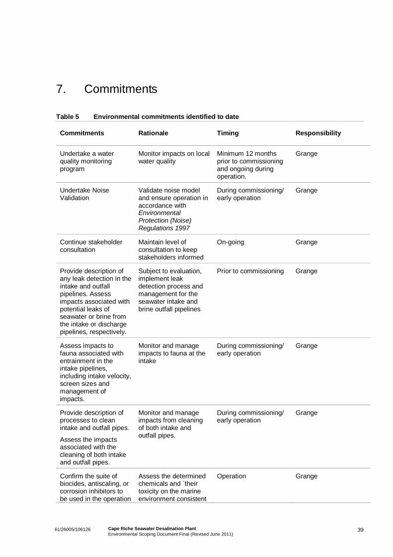
3961/26005/106126 Cape Riche Seawater Desalination PlantEnvironmental Scoping Document Final (Revised June 2011)
7. Commitments
Table 5 Environmental commitments identified to date
Commitments Rationale Timing Responsibility
Undertake a waterquality monitoringprogram
Monitor impacts on localwater quality
Minimum 12 monthsprior to commissioningand ongoing duringoperation.
Grange
Undertake NoiseValidation
Validate noise modeland ensure operation inaccordance withEnvironmentalProtection (Noise)Regulations 1997
During commissioning/early operation
Grange
Continue stakeholderconsultation
Maintain level ofconsultation to keepstakeholders informed
On-going Grange
Provide description ofany leak detection in theintake and outfallpipelines. Assessimpacts associated withpotential leaks ofseawater or brine fromthe intake or dischargepipelines, respectively.
Subject to evaluation,implement leakdetection process andmanagement for theseawater intake andbrine outfall pipelines
Prior to commissioning Grange
Assess impacts tofauna associated withentrainment in theintake pipelines,including intake velocity,screen sizes andmanagement ofimpacts.
Monitor and manageimpacts to fauna at theintake
During commissioning/early operation
Grange
Provide description ofprocesses to cleanintake and outfall pipes.
Assess the impactsassociated with thecleaning of both intakeand outfall pipes.
Monitor and manageimpacts from cleaningof both intake andoutfall pipes.
During commissioning/early operation
Grange
Confirm the suite ofbiocides, antiscaling, orcorrosion inhibitors tobe used in the operation
Assess the determinedchemicals and `theirtoxicity on the marineenvironment consistent
Operation Grange
4061/26005/106126 Cape Riche Seawater Desalination PlantEnvironmental Scoping Document Final (Revised June 2011)
Commitments Rationale Timing Responsibility
of the desalination plantand assessconsequential impacts.
with the water qualityrecommendations ofANZECC (2000).
4161/26005/106126 Cape Riche Seawater Desalination PlantEnvironmental Scoping Document Final (Revised June 2011)
8. Principles of Environmental Protection
Section 4A of the Environmental Protection Act 1986 establishes five principles of environmentalprotection, which have been expanded upon in EPA Position Statement No. 7 (EPA, 2004). Theprinciples of environmental protection have been taken into consideration during the planning and designof the proposal. A summary of the relevance and consideration to each of the five principles is includedin Table 6.
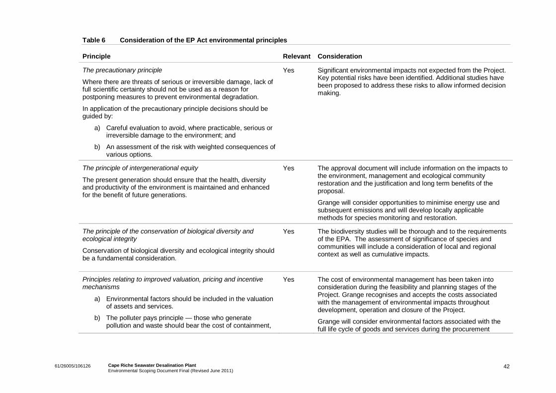
4261/26005/106126 Cape Riche Seawater Desalination PlantEnvironmental Scoping Document Final (Revised June 2011)
Table 6 Consideration of the EP Act environmental principles
Principle Relevant Consideration
The precautionary principle
Where there are threats of serious or irreversible damage, lack offull scientific certainty should not be used as a reason forpostponing measures to prevent environmental degradation.
In application of the precautionary principle decisions should beguided by:
a) Careful evaluation to avoid, where practicable, serious orirreversible damage to the environment; and
b) An assessment of the risk with weighted consequences ofvarious options.
Yes Significant environmental impacts not expected from the Project.Key potential risks have been identified. Additional studies havebeen proposed to address these risks to allow informed decisionmaking.
The principle of intergenerational equity
The present generation should ensure that the health, diversityand productivity of the environment is maintained and enhancedfor the benefit of future generations.
Yes The approval document will include information on the impacts tothe environment, management and ecological communityrestoration and the justification and long term benefits of theproposal.
Grange will consider opportunities to minimise energy use andsubsequent emissions and will develop locally applicablemethods for species monitoring and restoration.
The principle of the conservation of biological diversity andecological integrity
Conservation of biological diversity and ecological integrity shouldbe a fundamental consideration.
Yes The biodiversity studies will be thorough and to the requirementsof the EPA. The assessment of significance of species andcommunities will include a consideration of local and regionalcontext as well as cumulative impacts.
Principles relating to improved valuation, pricing and incentivemechanisms
a) Environmental factors should be included in the valuationof assets and services.
b) The polluter pays principle — those who generatepollution and waste should bear the cost of containment,
Yes The cost of environmental management has been taken intoconsideration during the feasibility and planning stages of theProject. Grange recognises and accepts the costs associatedwith the management of environmental impacts throughoutdevelopment, operation and closure of the Project.
Grange will consider environmental factors associated with thefull life cycle of goods and services during the procurement
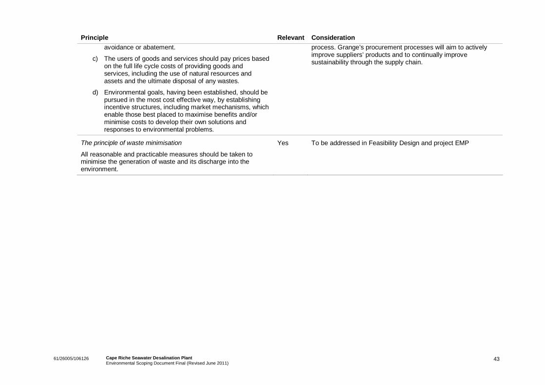
4361/26005/106126 Cape Riche Seawater Desalination PlantEnvironmental Scoping Document Final (Revised June 2011)
Principle Relevant Considerationavoidance or abatement.
c) The users of goods and services should pay prices basedon the full life cycle costs of providing goods andservices, including the use of natural resources andassets and the ultimate disposal of any wastes.
d) Environmental goals, having been established, should bepursued in the most cost effective way, by establishingincentive structures, including market mechanisms, whichenable those best placed to maximise benefits and/orminimise costs to develop their own solutions andresponses to environmental problems.
process. Grange’s procurement processes will aim to activelyimprove suppliers’ products and to continually improvesustainability through the supply chain.
The principle of waste minimisation
All reasonable and practicable measures should be taken tominimise the generation of waste and its discharge into theenvironment.
Yes To be addressed in Feasibility Design and project EMP
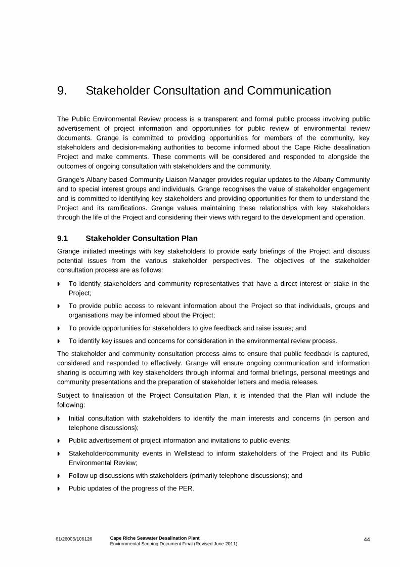
4461/26005/106126 Cape Riche Seawater Desalination PlantEnvironmental Scoping Document Final (Revised June 2011)
9. Stakeholder Consultation and Communication
The Public Environmental Review process is a transparent and formal public process involving publicadvertisement of project information and opportunities for public review of environmental reviewdocuments. Grange is committed to providing opportunities for members of the community, keystakeholders and decision-making authorities to become informed about the Cape Riche desalinationProject and make comments. These comments will be considered and responded to alongside theoutcomes of ongoing consultation with stakeholders and the community.
Grange’s Albany based Community Liaison Manager provides regular updates to the Albany Communityand to special interest groups and individuals. Grange recognises the value of stakeholder engagementand is committed to identifying key stakeholders and providing opportunities for them to understand theProject and its ramifications. Grange values maintaining these relationships with key stakeholdersthrough the life of the Project and considering their views with regard to the development and operation.
9.1 Stakeholder Consultation PlanGrange initiated meetings with key stakeholders to provide early briefings of the Project and discusspotential issues from the various stakeholder perspectives. The objectives of the stakeholderconsultation process are as follows:
To identify stakeholders and community representatives that have a direct interest or stake in theProject;
To provide public access to relevant information about the Project so that individuals, groups andorganisations may be informed about the Project;
To provide opportunities for stakeholders to give feedback and raise issues; and
To identify key issues and concerns for consideration in the environmental review process.
The stakeholder and community consultation process aims to ensure that public feedback is captured,considered and responded to effectively. Grange will ensure ongoing communication and informationsharing is occurring with key stakeholders through informal and formal briefings, personal meetings andcommunity presentations and the preparation of stakeholder letters and media releases.
Subject to finalisation of the Project Consultation Plan, it is intended that the Plan will include thefollowing:
Initial consultation with stakeholders to identify the main interests and concerns (in person andtelephone discussions);
Public advertisement of project information and invitations to public events;
Stakeholder/community events in Wellstead to inform stakeholders of the Project and its PublicEnvironmental Review;
Follow up discussions with stakeholders (primarily telephone discussions); and
Pubic updates of the progress of the PER.
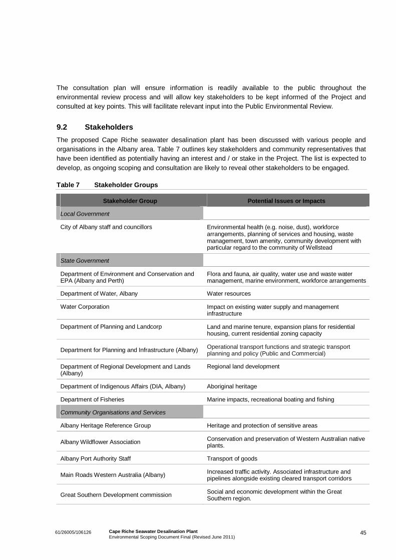
4561/26005/106126 Cape Riche Seawater Desalination PlantEnvironmental Scoping Document Final (Revised June 2011)
The consultation plan will ensure information is readily available to the public throughout theenvironmental review process and will allow key stakeholders to be kept informed of the Project andconsulted at key points. This will facilitate relevant input into the Public Environmental Review.
9.2 StakeholdersThe proposed Cape Riche seawater desalination plant has been discussed with various people andorganisations in the Albany area. Table 7 outlines key stakeholders and community representatives thathave been identified as potentially having an interest and / or stake in the Project. The list is expected todevelop, as ongoing scoping and consultation are likely to reveal other stakeholders to be engaged.
Table 7 Stakeholder Groups
Stakeholder Group Potential Issues or Impacts
Local Government
City of Albany staff and councillors Environmental health (e.g. noise, dust), workforcearrangements, planning of services and housing, wastemanagement, town amenity, community development withparticular regard to the community of Wellstead
State Government
Department of Environment and Conservation andEPA (Albany and Perth)
Flora and fauna, air quality, water use and waste watermanagement, marine environment, workforce arrangements
Department of Water, Albany Water resources
Water Corporation Impact on existing water supply and managementinfrastructure
Department of Planning and Landcorp Land and marine tenure, expansion plans for residentialhousing, current residential zoning capacity
Department for Planning and Infrastructure (Albany) Operational transport functions and strategic transportplanning and policy (Public and Commercial)
Department of Regional Development and Lands(Albany)
Regional land development
Department of Indigenous Affairs (DIA, Albany) Aboriginal heritage
Department of Fisheries Marine impacts, recreational boating and fishing
Community Organisations and Services
Albany Heritage Reference Group Heritage and protection of sensitive areas
Albany Wildflower Association Conservation and preservation of Western Australian nativeplants.
Albany Port Authority Staff Transport of goods
Main Roads Western Australia (Albany) Increased traffic activity. Associated infrastructure andpipelines alongside existing cleared transport corridors
Great Southern Development commission Social and economic development within the GreatSouthern region.
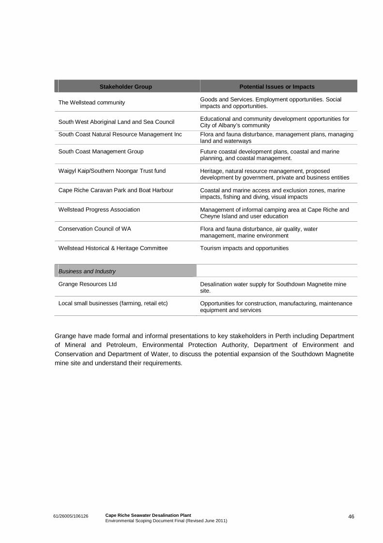
4661/26005/106126 Cape Riche Seawater Desalination PlantEnvironmental Scoping Document Final (Revised June 2011)
Stakeholder Group Potential Issues or Impacts
The Wellstead community Goods and Services. Employment opportunities. Socialimpacts and opportunities.
South West Aboriginal Land and Sea Council Educational and community development opportunities forCity of Albany’s community
South Coast Natural Resource Management Inc Flora and fauna disturbance, management plans, managingland and waterways
South Coast Management Group Future coastal development plans, coastal and marineplanning, and coastal management.
Waigyl Kaip/Southern Noongar Trust fund Heritage, natural resource management, proposeddevelopment by government, private and business entities
Cape Riche Caravan Park and Boat Harbour Coastal and marine access and exclusion zones, marineimpacts, fishing and diving, visual impacts
Wellstead Progress Association Management of informal camping area at Cape Riche andCheyne Island and user education
Conservation Council of WA Flora and fauna disturbance, air quality, watermanagement, marine environment
Wellstead Historical & Heritage Committee Tourism impacts and opportunities
Business and Industry
Grange Resources Ltd Desalination water supply for Southdown Magnetite minesite.
Local small businesses (farming, retail etc) Opportunities for construction, manufacturing, maintenanceequipment and services
Grange have made formal and informal presentations to key stakeholders in Perth including Departmentof Mineral and Petroleum, Environmental Protection Authority, Department of Environment andConservation and Department of Water, to discuss the potential expansion of the Southdown Magnetitemine site and understand their requirements.
4761/26005/106126 Cape Riche Seawater Desalination PlantEnvironmental Scoping Document Final (Revised June 2011)
10. Key Environmental Factors and Principles for thisProposal
This section summarises the anticipated environmental impacts and proposed management strategiesthat will be addressed in the PER. Table 8 outlines the proposed management to address each of theenvironmental factors identified in Section 5. For many factors, specific management requirements willneed to be further defined during the technical studies and investigations.
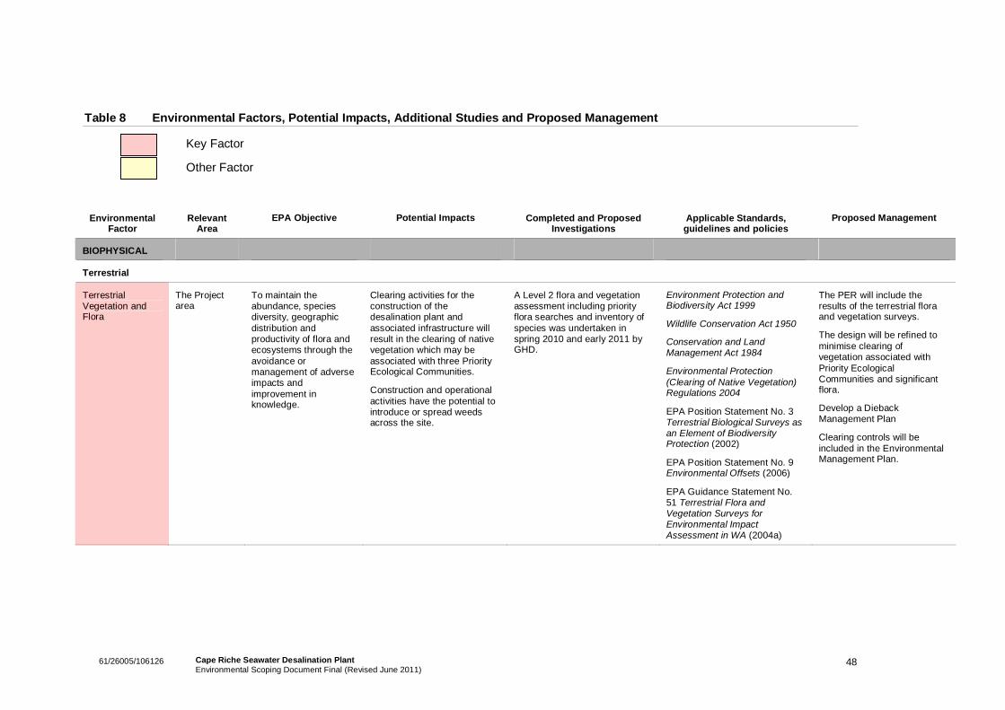
4861/26005/106126 Cape Riche Seawater Desalination PlantEnvironmental Scoping Document Final (Revised June 2011)
Table 8 Environmental Factors, Potential Impacts, Additional Studies and Proposed Management
Key Factor
Other Factor
EnvironmentalFactor
RelevantArea
EPA Objective Potential Impacts Completed and ProposedInvestigations
Applicable Standards,guidelines and policies
Proposed Management
BIOPHYSICAL
Terrestrial
TerrestrialVegetation andFlora
The Projectarea
To maintain theabundance, speciesdiversity, geographicdistribution andproductivity of flora andecosystems through theavoidance ormanagement of adverseimpacts andimprovement inknowledge.
Clearing activities for theconstruction of thedesalination plant andassociated infrastructure willresult in the clearing of nativevegetation which may beassociated with three PriorityEcological Communities.
Construction and operationalactivities have the potential tointroduce or spread weedsacross the site.
A Level 2 flora and vegetationassessment including priorityflora searches and inventory ofspecies was undertaken inspring 2010 and early 2011 byGHD.
Environment Protection andBiodiversity Act 1999
Wildlife Conservation Act 1950
Conservation and LandManagement Act 1984
Environmental Protection(Clearing of Native Vegetation)Regulations 2004
EPA Position Statement No. 3Terrestrial Biological Surveys asan Element of BiodiversityProtection (2002)
EPA Position Statement No. 9Environmental Offsets (2006)
EPA Guidance Statement No.51 Terrestrial Flora andVegetation Surveys forEnvironmental ImpactAssessment in WA (2004a)
The PER will include theresults of the terrestrial floraand vegetation surveys.
The design will be refined tominimise clearing ofvegetation associated withPriority EcologicalCommunities and significantflora.
Develop a DiebackManagement Plan
Clearing controls will beincluded in the EnvironmentalManagement Plan.
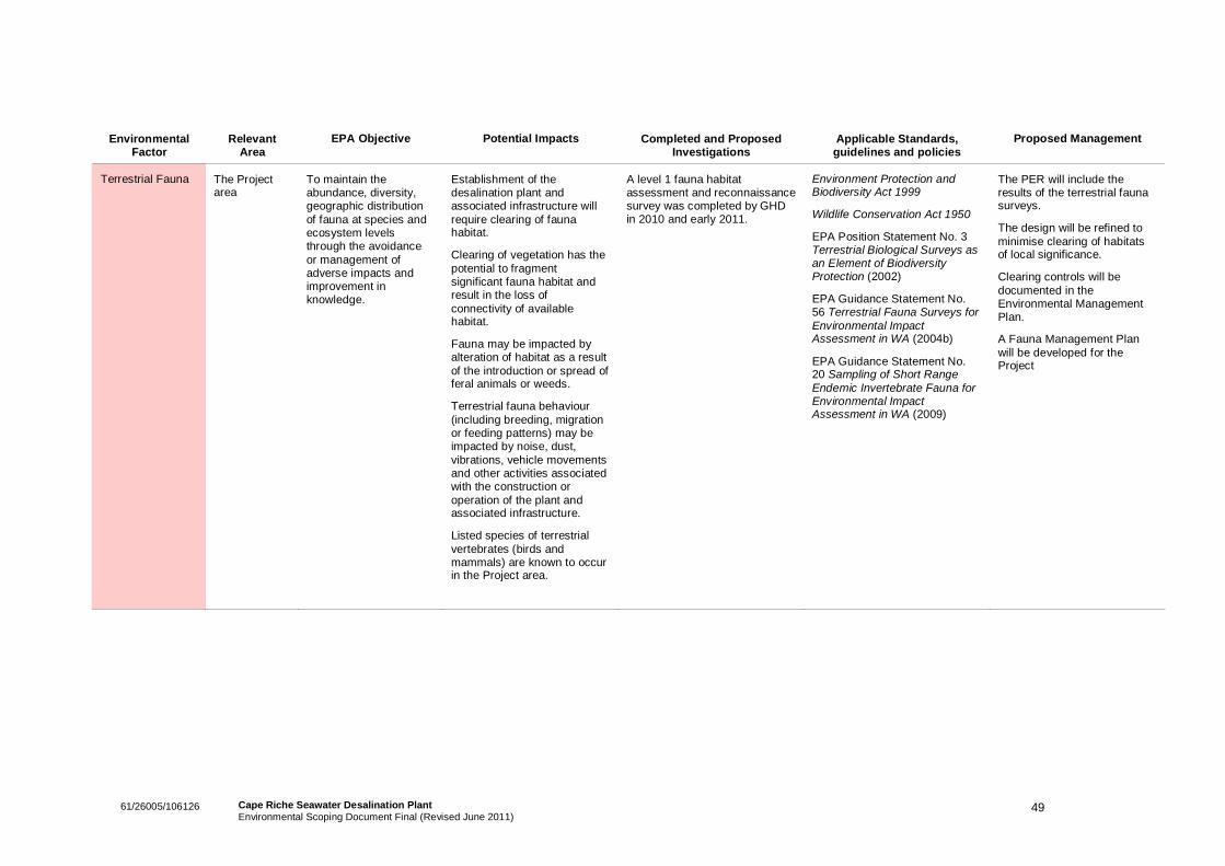
4961/26005/106126 Cape Riche Seawater Desalination PlantEnvironmental Scoping Document Final (Revised June 2011)
EnvironmentalFactor
RelevantArea
EPA Objective Potential Impacts Completed and ProposedInvestigations
Applicable Standards,guidelines and policies
Proposed Management
Terrestrial Fauna The Projectarea
To maintain theabundance, diversity,geographic distributionof fauna at species andecosystem levelsthrough the avoidanceor management ofadverse impacts andimprovement inknowledge.
Establishment of thedesalination plant andassociated infrastructure willrequire clearing of faunahabitat.
Clearing of vegetation has thepotential to fragmentsignificant fauna habitat andresult in the loss ofconnectivity of availablehabitat.
Fauna may be impacted byalteration of habitat as a resultof the introduction or spread offeral animals or weeds.
Terrestrial fauna behaviour(including breeding, migrationor feeding patterns) may beimpacted by noise, dust,vibrations, vehicle movementsand other activities associatedwith the construction oroperation of the plant andassociated infrastructure.
Listed species of terrestrialvertebrates (birds andmammals) are known to occurin the Project area.
A level 1 fauna habitatassessment and reconnaissancesurvey was completed by GHDin 2010 and early 2011.
Environment Protection andBiodiversity Act 1999
Wildlife Conservation Act 1950
EPA Position Statement No. 3Terrestrial Biological Surveys asan Element of BiodiversityProtection (2002)
EPA Guidance Statement No.56 Terrestrial Fauna Surveys forEnvironmental ImpactAssessment in WA (2004b)
EPA Guidance Statement No.20 Sampling of Short RangeEndemic Invertebrate Fauna forEnvironmental ImpactAssessment in WA (2009)
The PER will include theresults of the terrestrial faunasurveys.
The design will be refined tominimise clearing of habitatsof local significance.
Clearing controls will bedocumented in theEnvironmental ManagementPlan.
A Fauna Management Planwill be developed for theProject
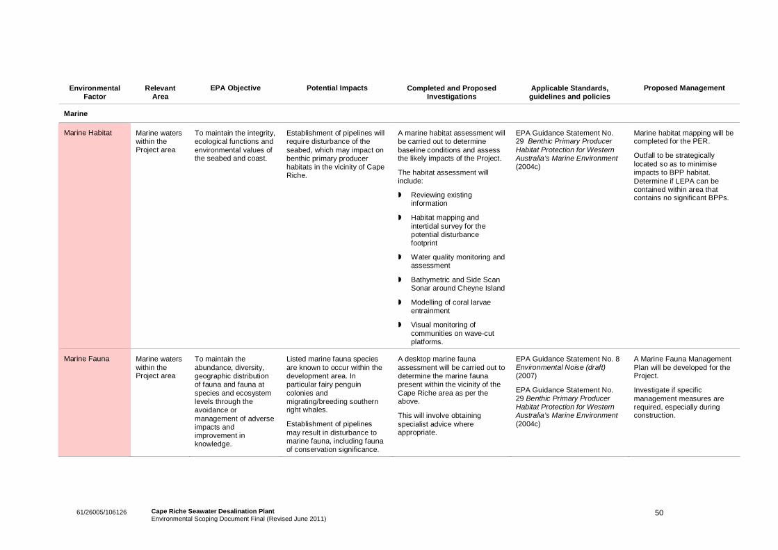
5061/26005/106126 Cape Riche Seawater Desalination PlantEnvironmental Scoping Document Final (Revised June 2011)
EnvironmentalFactor
RelevantArea
EPA Objective Potential Impacts Completed and ProposedInvestigations
Applicable Standards,guidelines and policies
Proposed Management
Marine
Marine Habitat Marine waterswithin theProject area
To maintain the integrity,ecological functions andenvironmental values ofthe seabed and coast.
Establishment of pipelines willrequire disturbance of theseabed, which may impact onbenthic primary producerhabitats in the vicinity of CapeRiche.
A marine habitat assessment willbe carried out to determinebaseline conditions and assessthe likely impacts of the Project.
The habitat assessment willinclude:
Reviewing existinginformation
Habitat mapping andintertidal survey for thepotential disturbancefootprint
Water quality monitoring andassessment
Bathymetric and Side ScanSonar around Cheyne Island
Modelling of coral larvaeentrainment
Visual monitoring ofcommunities on wave-cutplatforms.
EPA Guidance Statement No.29 Benthic Primary ProducerHabitat Protection for WesternAustralia’s Marine Environment(2004c)
Marine habitat mapping will becompleted for the PER.
Outfall to be strategicallylocated so as to minimiseimpacts to BPP habitat.Determine if LEPA can becontained within area thatcontains no significant BPPs.
Marine Fauna Marine waterswithin theProject area
To maintain theabundance, diversity,geographic distributionof fauna and fauna atspecies and ecosystemlevels through theavoidance ormanagement of adverseimpacts andimprovement inknowledge.
Listed marine fauna speciesare known to occur within thedevelopment area. Inparticular fairy penguincolonies andmigrating/breeding southernright whales.
Establishment of pipelinesmay result in disturbance tomarine fauna, including faunaof conservation significance.
A desktop marine faunaassessment will be carried out todetermine the marine faunapresent within the vicinity of theCape Riche area as per theabove.
This will involve obtainingspecialist advice whereappropriate.
EPA Guidance Statement No. 8Environmental Noise (draft)(2007)
EPA Guidance Statement No.29 Benthic Primary ProducerHabitat Protection for WesternAustralia’s Marine Environment(2004c)
A Marine Fauna ManagementPlan will be developed for theProject.
Investigate if specificmanagement measures arerequired, especially duringconstruction.
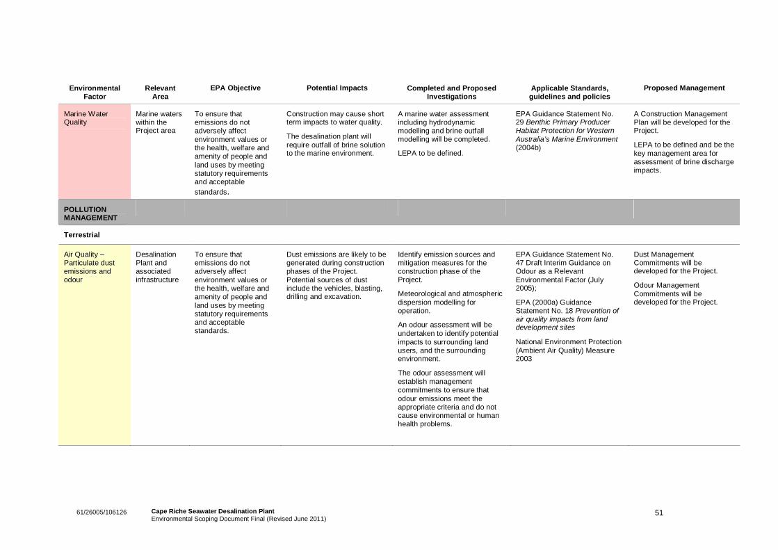
5161/26005/106126 Cape Riche Seawater Desalination PlantEnvironmental Scoping Document Final (Revised June 2011)
EnvironmentalFactor
RelevantArea
EPA Objective Potential Impacts Completed and ProposedInvestigations
Applicable Standards,guidelines and policies
Proposed Management
Marine WaterQuality
Marine waterswithin theProject area
To ensure thatemissions do notadversely affectenvironment values orthe health, welfare andamenity of people andland uses by meetingstatutory requirementsand acceptablestandards.
Construction may cause shortterm impacts to water quality.
The desalination plant willrequire outfall of brine solutionto the marine environment.
A marine water assessmentincluding hydrodynamicmodelling and brine outfallmodelling will be completed.
LEPA to be defined.
EPA Guidance Statement No.29 Benthic Primary ProducerHabitat Protection for WesternAustralia’s Marine Environment(2004b)
A Construction ManagementPlan will be developed for theProject.
LEPA to be defined and be thekey management area forassessment of brine dischargeimpacts.
POLLUTIONMANAGEMENT
Terrestrial
Air Quality –Particulate dustemissions andodour
DesalinationPlant andassociatedinfrastructure
To ensure thatemissions do notadversely affectenvironment values orthe health, welfare andamenity of people andland uses by meetingstatutory requirementsand acceptablestandards.
Dust emissions are likely to begenerated during constructionphases of the Project.Potential sources of dustinclude the vehicles, blasting,drilling and excavation.
Identify emission sources andmitigation measures for theconstruction phase of theProject.
Meteorological and atmosphericdispersion modelling foroperation.
An odour assessment will beundertaken to identify potentialimpacts to surrounding landusers, and the surroundingenvironment.
The odour assessment willestablish managementcommitments to ensure thatodour emissions meet theappropriate criteria and do notcause environmental or humanhealth problems.
EPA Guidance Statement No.47 Draft Interim Guidance onOdour as a RelevantEnvironmental Factor (July2005);
EPA (2000a) GuidanceStatement No. 18 Prevention ofair quality impacts from landdevelopment sites
National Environment Protection(Ambient Air Quality) Measure2003
Dust ManagementCommitments will bedeveloped for the Project.
Odour ManagementCommitments will bedeveloped for the Project.
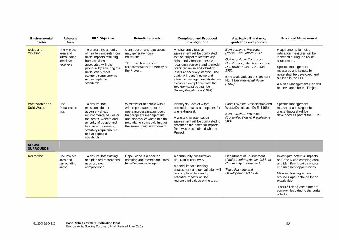
5261/26005/106126 Cape Riche Seawater Desalination PlantEnvironmental Scoping Document Final (Revised June 2011)
EnvironmentalFactor
RelevantArea
EPA Objective Potential Impacts Completed and ProposedInvestigations
Applicable Standards,guidelines and policies
Proposed Management
Noise andVibration
The Projectarea andsurroundingsensitivereceivers
To protect the amenityof nearby residents fromnoise impacts resultingfrom activitiesassociated with theproposal by ensuring thenoise levels meetstatutory requirementsand acceptablestandards.
Construction and operationsmay generate noiseemissions.
There are few sensitivereceptors within the vicinity ofthe Project.
A noise and vibrationassessment will be completedfor the Project to identify keynoise and vibration sensitivelocations/receivers and to modelpredicted noise and vibrationlevels at each key location. Thestudy will identify noise andvibration management strategiesto ensure compliance with theEnvironmental Protection(Noise) Regulations (1997).
Environmental Protection(Noise) Regulations 1997.
Guide to Noise Control onConstruction, Maintenance andDemolition Sites – AS 2436 –1981.
EPA Draft Guidance StatementNo. 8 Environmental Noise(2007)
Requirements for noisemitigation measures will beidentified during the noiseassessment.
Specific managementmeasures and targets fornoise shall be developed andoutlined in the PER.
A Noise Management Plan willbe developed for the Project.
Wastewater andSolid Waste
TheDesalinationsite.
To ensure thatemissions do notadversely affectenvironmental values orthe health, welfare andamenity of people andland uses by meetingstatutory requirementsand acceptablestandards.
Wastewater and solid wastewill be generated from theoperating desalination plant.Inappropriate managementand disposal of waste has thepotential to negatively impactthe surrounding environment.
Identify sources of waste,potential impacts and options forwaste disposal.
A waste characterisationassessment will be completed todetermine the potential impactsfrom waste associated with theProject.
Landfill Waste Classification andWaste Definitions (DoE, 1996)
Environmental Protection(Controlled Waste) Regulations2004
Specific managementmeasures and targets forwaste disposal will bedeveloped as part of the PER.
SOCIALSURROUNDS
Recreation The Projectarea andsurroundingareas.
To ensure that existingand planned recreationaluses are notcompromised.
Cape Riche is a popularcamping and recreational areafrom December to April.
A community consultationprogram is underway.
A social impact scopingassessment and consultation willbe completed to identifypotential impacts on therecreational values of the area.
Department of Environment(2003) Interim Industry Guide toCommunity Involvement.
Town Planning andDevelopment Act 1928
Investigate potential impactson Cape Riche camping areaand identify mitigation and/orenhancement opportunities.
Maintain boating accessaround Cape Riche as far aspracticable.
Ensure fishing areas are notcompromised due to the outfallactivity.
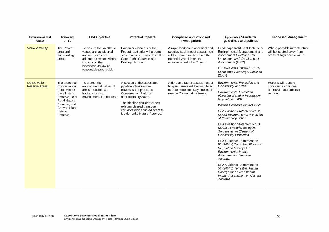
5361/26005/106126 Cape Riche Seawater Desalination PlantEnvironmental Scoping Document Final (Revised June 2011)
EnvironmentalFactor
RelevantArea
EPA Objective Potential Impacts Completed and ProposedInvestigations
Applicable Standards,guidelines and policies
Proposed Management
Visual Amenity The Projectarea andsurroundingareas.
To ensure that aestheticvalues are consideredand measures areadopted to reduce visualimpacts on thelandscape as low asreasonably practicable.
Particular elements of theProject, particularly the pumpstation may be visible from theCape Riche Caravan andBoating Harbour
A rapid landscape appraisal andscenic/visual impact assessmentwill be carried out to define thepotential visual impactsassociated with the Project.
Landscape Institute & Institute ofEnvironmental Management andAssessment Guidelines forLandscape and Visual ImpactAssessment (2002)
DPI Western Australian VisualLandscape Planning Guidelines(2007)
Where possible infrastructurewill be located away fromareas of high scenic value.
ConservationReserve Areas
The proposedConservationPark, MettlerLake NatureReserve, BasilRoad NatureReserve, andCheyne IslandNatureReserve.
To protect theenvironmental values ofareas identified ashaving significantenvironmental attributes.
A section of the associatedpipeline infrastructuretraverses the proposedConservation Park forapproximately 800m.
The pipeline corridor followsexisting cleared transportcorridors which run adjacent toMettler Lake Nature Reserve.
A flora and fauna assessment offootprint areas will be completedto determine the likely effects onnearby Conservation Areas.
Environmental Protection andBiodiversity Act 1999
Environmental Protection(Clearing of Native Vegetation)Regulations 2004
Wildlife Conservation Act 1950
EPA Position Statement No. 2(2000) Environmental Protectionof Native Vegetation
EPA Position Statement No. 3(2002) Terrestrial BiologicalSurveys as an Element ofBiodiversity Protection
EPA Guidance Statement No.51 (2004a) Terrestrial Flora andVegetation Surveys forEnvironmental ImpactAssessment in WesternAustralia
EPA Guidance Statement No.56 (2004b) Terrestrial FaunaSurveys for EnvironmentalImpact Assessment in WesternAustralia
Reports will identifyconstraints additionalapprovals and affects ifrequired.
5461/26005/106126 Cape Riche Seawater Desalination PlantEnvironmental Scoping Document Final (Revised June 2011)
11. References
360 Environmental (2010) Cape Riche Marine Water Quality Monitoring Survey Report. GrangeResources.
ABS (2006) Census QuickStats. Available from http://www.censusdata.abs.gov.au/, Accessed 21December 2010.
Australian Cultural Heritage Management (2010) Aboriginal Archaeological and Ethnographic SurveyReport, Grange Resources Desalination Pipeline, Cape Riche, Great Southern, WA. Prepared forGrange Resources, February 2010.
Bureau of Meteorology Climate Data Online. Available from http://www.bom.gov.au/climate/data/
City of Albany (2010) Economic Development. Available from http://www.albany.wa.gov.au/about-albany/economic-development/
City of Albany (2000) Municipal Heritage Inventory Review: Volume IV of IV. Outer Albany Places fromA-Z.
Comer, S., Gilfillan, S., Grant, M., Barrett, S., and Anderson, L. (2001) Esperance 1 (ESP1 - Fitzgeraldsubregion). Department of Conservation and Land Management. Available fromhttp://www.dec.wa.gov.au/pdf/science/bio_audit/esperance01_p188-208.pdf, Accessed 20 December2010.
Department of Conservation and Land Management (1992) South Coast Region Regional managementPlan 1992-2002. Management Plan No. 24. Prepared by the Department of Conservation and LandManagement for the National Parks and Nature Conservation Authority and the Lands and ForestCommission of Western Australia.
Department of Conservation and Land Management (1991) South Coast Region Regional ManagementPlan 1992-2002. Management Plan No. 24. Department of Conservation and Land Management, Perth,Western Australia.
Department of Environment and Conservation (2010) South Coast Draft Regional Marine Strategic Plan.Government of Western Australia. Perth.
Department of Environment and Conservation (2010) Oceans of Opportunity: A proposed strategicframework for marine waters of Western Australia’s South Coast.
Department of Environment and Heritage (2004) Southern Right Whale Recover Plan 2005 – 2010.National Heritage Trust. Available fromhttp://www.environment.gov.au/biodiversity/threatened/publications/recovery/e-australis/pubs/e-australis.pdf, Accessed 14 January 2011.
Department of Environment, Water, Heritage and the Arts (2007) The South-west Marine BioregionalPlan: Bioregional Profile. A Description of the Ecosystems, Conservation Values and Uses of the South-west Marine Region. Available from http://www.environment.gov.au/coasts/mbp/publications/south-west/pubs/sw-profile-full.pdf, Accessed 17 December 2010.
Department of Water (2010a) Lower Great Southern water resource development strategy, Departmentof Water, Perth, Western Australia.
5561/26005/106126 Cape Riche Seawater Desalination PlantEnvironmental Scoping Document Final (Revised June 2011)
Department of Water (2010b) Geographic Data Atlas: Cape Riche Search results. Available fromhttp://www.water.wa.gov.au/idelve/dowdataext/index.jsp, Accessed 20 December 2010.
Ecologia (2007) Albany Iron Ore Project: Public environmental Review. Southdown Magnetite ProposalEPA Assessment No 1596. Grange Resources Limited.
EPA (2010) Guide to preparing and Environmental Scoping Document. Office of the EnvironmentalProtection Authority, 30/12/2010.
South Coast NRM (2004) Southern Prospects 2004 – 2009 DRAFT: South Coast Regional Strategy forNatural Resource Management. Marine Biodiversity: Management and Planning in the South Coast.Available from:http://www.southcoastnrm.com.au/files/1/files/Background_Paper_06_Marine_Biodiversity.pdf, Accessed17 December 2010.
Water Corporation (2008) Southern Seawater Desalination Project: Visual Impact Assessment. Availablefromhttp://www.watercorporation.com.au/_files/PublicationsRegister/15/PER/Visual_Impact_Assessment.pdf,Accessed 21 December 2010.
Water Corporation (2008) Water Forever: Option for our water future. Available fromhttp://www.watercorporation.com.au/_files/PublicationsRegister/22/Water_Forever_Options_Report.pdf,Accessed 21 December 2010.
Water Corporation (2010) Water Forever: Lower Great Southern. Final Report. Available fromhttp://www.thinking50.com.au/go/lower-great-southern. Accessed 21 December 2010.
Water and Rivers Commission (1999) Albany Waterways Resource Book. Report prepared for theAlbany Waterways Management Authority.
Water and Rivers Commission (2001) South Coast Water Reserve and Limeburners Creek CatchmentArea Water Resource Protection Plan, Water and Rivers Commission, Perth.
Wellstead Community Resource Centre (2011) Our Community. Available fromhttp://www.wellstead.crc.net.au/The%20Resource%20Center/our-community