Embed Size (px)
Citation preview
Remedial Design Work Plan Remedial Design Lower 8.3 Miles of the Lower Passaic River, Operable Unit Two of the Diamond Alkali Superfund Site In and About Essex, Hudson, Bergen and Passaic Counties – New Jersey
March 2017Revision 2
LPROU2-17-2.2-0003

LPROU2‐RDWP_rev‐2_March 2017
Remedial Design Work Plan Remedial Design Lower 8.3 Miles of the Lower Passaic River Operable Unit Two of the Diamond Alkali Superfund Site In and About Essex, Hudson, Bergen and Passaic Counties – New Jersey
March 2017 Revision 2
LPROU2-17-2.2-0003
PREPARED ON BEHALF OF PREPARED BY
Settling Party Supervising Contractor
Glenn Springs Holdings, Inc. A Subsidiary of Occidental Petroleum 5 Greenway Plaza, Suite 110 Houston, Texas 77046
Tetra Tech Inc. 6 Century Drive, 3rd Floor Parsippany, NJ 07054
P +1-973-630-8000F +1-973-630-8165tetratech.com

LPROU2‐RDWP_rev‐2_March 2017

Lower 8.3 Miles of the Lower Passaic River Remedial Design Work Plan OU 2 of the Diamond Alkali Superfund Site Revision 2, March 2017
LPROU2‐RDWP_rev‐2_March 2017
REVISION RECORD
Revisions to this Work Plan will be reviewed and approved by someone qualified to have prepared the original document. All revisions must be authorized by the Tetra Tech Project Manager and the Glenn Springs Holdings, Inc. Project Coordinator, or their designee(s) and documented below.
Revision Date Portions Affected Reason Authorized By Agency
Submittal
1 2
3/8/17
3/21/17
Various 1.1, 2.2.1
EPA comments EPA comments
Juan Somoano (GSH) &
Steve McGee (Tetra Tech)
Juan Somoano
(GSH) & Steve McGee (Tetra Tech)
Yes (EPA; NJDEP)
Yes (EPA; NJDEP)

Lower 8.3 Miles of the Lower Passaic River Remedial Design Work Plan OU 2 of the Diamond Alkali Superfund Site Revision 2, March 2017
ii
LPROU2‐RDWP_rev‐2_March 2017
TABLE OF CONTENTS
ACRONYMS / ABBREVIATIONS .................................................................................................................. v
1 INTRODUCTION .................................................................................................................................... 1
1.1 REMEDIAL ACTION SUMMARY .............................................................................................. 1
1.2 PROJECT SETTING ................................................................................................................. 2
1.3 REMEDIAL DESIGN OBJECTIVES .......................................................................................... 2
1.4 OVERVIEW OF REMEDIAL DESIGN PROCESS .................................................................... 3
1.5 PERMITTING AND REGULATORY REQUIREMENTS ............................................................ 3
2 PRE-DESIGN ACTIVITIES .................................................................................................................... 5
2.1 PRE-DESIGN INVESTIGATION AND CHARACTERIZATION ................................................. 5
2.1.1 Description of Pre-Design Activities .......................................................................... 5
2.1.2 Geophysical and Bathymetric Surveys ...................................................................... 6
2.1.3 Debris and Utility Survey ........................................................................................... 7
2.1.4 Sediment Core Collection and Analysis .................................................................... 7
2.1.5 Pore Water Sampling ................................................................................................ 8
2.1.6 Dredge Elutriate Testing ............................................................................................ 9
2.1.7 Bulkhead and Shoreline Evaluation .......................................................................... 9
2.1.8 Fish Studies ............................................................................................................. 10
2.1.9 Phase I and II Cultural Surveys ............................................................................... 10
2.1.10 Habitat Survey ......................................................................................................... 11
2.1.11 Baseline/Performance Standard Water Column Sampling Plan ............................. 11
2.1.12 Borrow Site Assessment ......................................................................................... 12
2.2 SITE WIDE MONITORING PLAN ........................................................................................... 12
2.2.1 Surficial Sediment Sampling Plan ........................................................................... 13
2.2.2 Water Column Sampling Plan ................................................................................. 13
2.2.3 Long-term Fish and Invertebrate Tissue Monitoring Studies .................................. 13
2.3 REVIEW OF PERFORMANCE STANDARDS ........................................................................ 14
2.4 BASE MAPPING...................................................................................................................... 14
2.5 SEDIMENT PROCESSING SITE SELECTION AND EVALUATION ...................................... 14
2.6 TREATABILITY STUDIES ....................................................................................................... 15
3 REMEDIAL DESIGN PROCESS ......................................................................................................... 18
3.1 DESIGN PHASING AND ELEMENTS..................................................................................... 18
3.1.1 Plans and Technical Approaches for Remedy Design ............................................ 19
3.1.2 Performance Standards for Dredging and Capping ................................................ 22
3.1.3 Dredged Material Transport .................................................................................... 23
3.1.4 Sediment Processing and Water Treatment ........................................................... 25
3.1.5 Sediment Transportation and Disposal ................................................................... 26

Lower 8.3 Miles of the Lower Passaic River Remedial Design Work Plan OU 2 of the Diamond Alkali Superfund Site Revision 2, March 2017
iii
LPROU2‐RDWP_rev‐2_March 2017
3.1.6 Dredged Materials Management ............................................................................. 27
3.1.7 Habitat Restoration .................................................................................................. 28
3.2 ENGINEERING STUDIES ....................................................................................................... 28
4 REMEDIAL DESIGN DELIVERABLES ................................................................................................ 30
4.1 PROGRESS REPORTS .......................................................................................................... 30
4.2 DESIGN SUPPORT DELIVERABLES .................................................................................... 30
4.2.1 Work Plans .............................................................................................................. 30
4.2.2 Reports .................................................................................................................... 31
4.3 ENGINEERING DESIGN DELIVERABLES ............................................................................ 32
4.3.1 Preliminary (30%) Remedial Design ....................................................................... 32
4.3.2 Intermediate (60%) Remedial Design ..................................................................... 36
4.3.3 Value Engineering Analysis ..................................................................................... 37
4.3.4 Pre-Final (95%) Remedial Design ........................................................................... 38
4.3.5 Final (100%) Remedial Design ................................................................................ 41
5 REMEDIAL DESIGN SCHEDULE ....................................................................................................... 42
6 REFERENCES ..................................................................................................................................... 44

Lower 8.3 Miles of the Lower Passaic River Remedial Design Work Plan OU 2 of the Diamond Alkali Superfund Site Revision 2, March 2017
iv
LPROU2‐RDWP_rev‐2_March 2017
LIST OF TABLES
Table 2-1. Geophysical Survey Summary (in Section 2.1.2) Table 2-2. EPA Identified Potential Sediment Processing Sites (in Section 2.5) Table 4-1. Example Mass Balance Calculation for Sediment Dredging and Processing (in Section 4.3.1.1) Table 5-1. Remedial Design Schedule (in Section 5)
LIST OF FIGURES
Figure 1-1. OU 2 Location and Vicinity Map Figure 1-2. Site Operable Units and Removal Actions Figure 1-3. Selected Remedy Figure 2-1. EPA Identified Potential Sites for Processing Facility
LIST OF APPENDICES
Appendix A Emergency Response Plan Appendix B Applicable or Relevant and Appropriate Requirements (ARARs)

Lower 8.3 Miles of the Lower Passaic River Remedial Design Work Plan OU 2 of the Diamond Alkali Superfund Site Revision 2, March 2017
v
LPROU2‐RDWP_rev‐2_March 2017
ACRONYMS / ABBREVIATIONS
Acronyms/Abbreviations Definition
AOC Administrative Settlement Agreement and Order on Consent
APE area of potential effects
ARARs Applicable or Relevant and Appropriate Requirements
BMP best management practice
CERCLA Comprehensive Environmental Response, Compensation, and Liability Act
COC contaminant of concern
CQA/QCP Construction Quality Assurance/Quality Control Plan
CQAP Construction Quality Assurance Plan
CSI Construction Specifications Institute
cy cubic yard
DDT dichlorodiphenyltrichloroethane
EFDC Environmental Fluid Dynamics Code
EPA U.S. Environmental Protection Agency
ESA environmental site assessment
FCS final candidate sites
FFS Focused Feasibility Study
GIS geographic information system
GOH gross operating hour
GPS global positioning system
GSH Glenn Springs Holdings, Inc.
HASP Health and Safety Plan
HEC-RAS Hydrologic Engineering Center – River Analysis System
IC institutional control
ICIAP Institutional Controls, Implementation and Assurance Plan

Lower 8.3 Miles of the Lower Passaic River Remedial Design Work Plan OU 2 of the Diamond Alkali Superfund Site Revision 2, March 2017
vi
LPROU2‐RDWP_rev‐2_March 2017
Acronyms/Abbreviations Definition
LiDAR Light Detection And Ranging
LPRSA Lower Passaic River Study Area
MBE multibeam echosounder
MPES multi-phase echosounder
mtds metric tons of dry solids
mtons metric tons
NCP National Contingency Plan
NHPA National Historic Preservation Act
NJDEP New Jersey Department of Environmental Protection
NJ HPO New Jersey Historic Preservation Office
NMFS National Marine Fisheries Service
O&M operation and maintenance
OU Operable Unit
OU 2 Operable Unit 2 (the lower 8.3 miles of the Lower Passaic River); the Project
PAH polycyclic aromatic hydrocarbon
PCB polychlorinated biphenyls
PCS preliminary candidate site
PDI pre-design investigation
PFD process flow diagram
PMP Project Management Plan
Project Lower 8.3 miles of the Lower Passaic River (Operable Unit Two, “OU 2”) of the Diamond Alkali Superfund Site (the “Site”), located in and about Essex, Hudson, Bergen and Passaic Counties, New Jersey
PS Performance Standards
QA quality assurance
QAPP Quality Assurance Project Plan
QC quality control
RA remedial action
RAO Remedial Action Objective

Lower 8.3 Miles of the Lower Passaic River Remedial Design Work Plan OU 2 of the Diamond Alkali Superfund Site Revision 2, March 2017
vii
LPROU2‐RDWP_rev‐2_March 2017
Acronyms/Abbreviations Definition
RCRA Resource Conservation and Recovery Act
RD remedial design
RDWP Remedial Design Work Plan
RI/FS Remedial Investigation/Feasibility Study
RI/FFS Remedial Investigation/Focused Feasibility Study
RM river mile
ROD Record of Decision
SBE single beam echosounder
SHPO State Historic Preservation Office
Site Diamond Alkali Superfund Site
SOW scope of work or statement of work
SWMP Site Wide Monitoring Plan
TBC to-be-considered criteria
TODP Transportation and Off-Site Disposal Plan
TSWP Treatability Study Work Plan
UHC underlying hazardous constituent
USACE U.S. Army Corps of Engineers
UTS universal treatment standard
VE value engineering
WP Work Plan

Lower 8.3 Miles of the Lower Passaic River Remedial Design Work Plan OU 2 of the Diamond Alkali Superfund Site Revision 2, March 2017
1 LPROU2‐RDWP_rev‐2_March 2017
1 INTRODUCTION
This Remedial Design Work Plan (RDWP) has been prepared pursuant to the requirements set forth in the Administrative Settlement Agreement and Order on Consent for Remedial Design (Settlement Agreement) between the U.S. Environmental Protection Agency (EPA) and Settling Party, effective September 30, 2016, for the lower 8.3 miles of the Lower Passaic River (Operable Unit Two, “OU 2,”) of the Diamond Alkali Superfund Site (the “Site”) located in and about Essex, Hudson, Bergen, and Passaic Counties, New Jersey, refer to Figure 1-1 (Project).
The Settling Party, as defined in the Settlement Agreement, is Occidental Chemical Corporation. Communications associated with, and execution of, the Settlement Agreement are being led by Glenn Springs Holdings, Inc. (GSH) on behalf of Occidental Chemical Corporation.
The Settlement Agreement provides that the Settling Party shall undertake a remedial design, including various procedures and technical analyses, to produce a detailed set of plans and specifications for implementation of the Remedial Action selected in EPA's March 3, 2016 Record of Decision (ROD). Remedial design activities include the completion of all pre-design and design activities and deliverables associated with implementation of the Remedial Design for the remedy selected in the ROD. The selected remedy was chosen by the EPA in accordance with the Comprehensive Environmental Response, Compensation, and Liability Act of 1980 (CERCLA), as amended, 42 U.S.C. §§9601-9675, and, to the extent practicable, the National Oil and Hazardous Substances Pollution Contingency Plan (NCP).
1.1 REMEDIAL ACTION SUMMARY
The selected remedy for OU 2 set forth in the ROD is described as a final action for the sediments and an interim action for the water column. Phase 1 of a non-time-critical removal action (referred to as the “Tierra Removal”) was completed in 2012. It addressed contaminated sediments adjacent to the former Diamond Alkali facility located at 80 – 120 Lister Avenue in Newark, New Jersey (OU 1). Siting and use of a confined disposal facility as a receptacle for the dredged materials from Phase 2 of the Tierra Removal, as required by the respective Administrative Order on Consent, may no longer be practicable. If the approach for addressing the Phase 2 sediments has not been determined, this work will be integrated with the OU 2 remedy in a coordinated and consistent manner. OU 2 is comprised of the lower 8.3 miles of the Lower Passaic River. OU 3 is comprised of the entire 17 miles of the Lower Passaic River Study Area (LPRSA), for which a remedy will be selected to address surface water; and the area upstream of river mile (RM) 8.3, for which a remedy will be selected to address sediments, following completion of a remedial investigation and feasibility study (RI/FS). The remedy selected for OU 4 will address the Newark Bay Study Area. The Site Operable Units and Removal Actions are shown in Figure 1-2. This RDWP addresses only OU 2. The Selected Remedy for OU 2 is shown in Figure 1-3.
The selected remedy for OU 2 is described in the ROD as including the following:
Dredging. Bank-to-bank dredging of approximately 3.5 million cubic yards (cy) of contaminated sediments prior to cap installation. The average depth of dredging is estimated to be 2.5 feet, except in the lower 1.7 miles of the federally authorized navigation channel, which will be dredged to varying depths. The remedy, after dredging and capping, must not increase flooding potential, and must accommodate commercial use of the navigation channel and anticipated future recreational use of the area upstream of RM 1.7.
Sediment Dewatering and Disposal. Dredged sediment is to be dewatered and transported to a permitted treatment facility and/or landfill for disposal.

Lower 8.3 Miles of the Lower Passaic River Remedial Design Work Plan OU 2 of the Diamond Alkali Superfund Site Revision 2, March 2017
2 LPROU2‐RDWP_rev‐2_March 2017
Capping. A bank-to-bank engineered cap over the sediment, except in areas where backfill may be placed after all contaminated sediments have been removed. Capping of dredged mudflats will include a habitat reconstruction layer.
Institutional Controls. These controls will be used to protect the engineered caps and maintain prohibitions on fish and crab consumption until NJDEP, in consultation with EPA, determines they can be lifted or adjusted based on data from long-term monitoring. Additional community outreach will be conducted to encourage greater awareness of the fish and crab consumption prohibitions.
Long-term Monitoring and Maintenance. Long-term monitoring and maintenance of the engineered cap, and long-term monitoring of sediment, fish, crab, and water to determine when interim remediation milestones, remediation goals, and remedial action objectives (RAOs) are achieved.
1.2 PROJECT SETTING
OU 2 consists of approximately 650 acres located in northeastern New Jersey and extends from the confluence of the Lower Passaic River with Newark Bay at RM 0 to RM 8.3, which is near the City of Newark and Belleville Township border. It is located in a highly developed urban area with a population of approximately 1.4 million, with Essex County to the west and Hudson County to the east. The land uses around Newark Bay (RM 0), at the mouth of the river, are primarily commercial and industrial. At RM 4, residential and recreational uses are present as well, resulting in mixed usage. Near RM 7, park land, suburban neighborhoods, marinas and boat launches are present. Approximately 95 percent of the OU 2 shoreline area is comprised of bulkheads or riprap shorelines, while the remaining 5 percent consists of aquatic vegetation. Mudflats comprise approximately 100 acres of OU 2, and provide habitat for fish, aquatic organisms, blue crab, and waterfowl.
The Site includes a federally authorized navigation channel, constructed in the 1880s, that originally extended from RM 0 to RM 8.1. It was subsequently expanded to RM 15.4, with depths of 30 feet below mean low water (MLW) from RM 0 to RM 2.6, 20 feet below MLW from RM 2.6 to RM 4.6, 16 feet below MLW from RM 4.6 to RM 8.1, and 10 feet below MLW from RM 8.1 to RM 15.4. The channel was maintained by the U.S. Army Corps of Engineers (USACE) through the 1950s, and RM 9.0 to RM 10.2 was maintained until 1976. The channel below RM 1.9 was maintained until 1983.
As this maintenance declined and later stopped, the channel filled with sediments. Industrial and municipal discharges during this period included chemical loading coincident with the sediment accumulation.
The cross-sectional area of OU 2 decreases from RM 0 to RM 8.3, with a constriction at RM 8.3. Below this constriction, the sediment is predominantly fine-grained silts, with pockets of sand and gravel. The estimated inventory of contaminated sediments is approximately 9.7 million cy. Contaminants of concern (COCs) include dioxins and furans, polychlorinated biphenyls (PCBs), mercury, copper, lead, DDT (dichlorodiphenyltrichloroethane) and its primary breakdown products, dieldrin, and polycyclic aromatic hydrocarbons (PAHs).
1.3 REMEDIAL DESIGN OBJECTIVES
The primary objective of the RD is to achieve an expedited, cost-effective remedy that is consistent with the ROD and the SOW. The following RAOs have been established for OU 2:
Reduce cancer risks and noncancer health hazards for people eating fish and crab by reducing the concentrations of COCs in the sediments.
Reduce the risks to ecological receptors by reducing the concentrations of COCs in the sediments.
Reduce the migration of COC-contaminated sediments to upstream portions of the Lower Passaic River and to Newark Bay and the New York-New Jersey Harbor Estuary.

Lower 8.3 Miles of the Lower Passaic River Remedial Design Work Plan OU 2 of the Diamond Alkali Superfund Site Revision 2, March 2017
3 LPROU2‐RDWP_rev‐2_March 2017
These RAOs address human exposure through fish and/or crab consumption, and ecological exposures. The unacceptable exposures identified in the risk assessments are primarily derived from elevated COC concentrations in surface sediments that result in bioaccumulation of COCs in fish and crab. Addressing these sediments will reduce COC concentrations in biota, including fish and crab tissue, thereby significantly reducing potential human health risks and hazards, and ecological risks. By addressing exposure to and mobility of the surface sediments, the remedial action (RA) is expected to achieve the RAOs.
This RDWP summarizes background information pertinent to the design, describes the design process and approach, and builds upon prior work leading up to the design. This RDWP describes the following design elements, as required in the SOW:
Plans and technical approaches for implementing all RD activities identified in the SOW, in the RDWP, or required by EPA to be conducted to develop the RD;
Descriptions of any areas requiring clarification and/or anticipated problems (e.g., data gaps);
Description of any applicable permitting requirements and other regulatory requirements;
Description of plans for obtaining access in connection with the work, such as property acquisition, property leases, and/or easements;
Description of supporting design calculations and modeling runs to be performed in support of the design;
A plan for identification, screening and selection of disposal sites for waste material;
A description of plans for obtaining Congressional action to modify the depths and de-authorize portions of the federally authorized navigation channel in accordance with the navigation channel depths included in the selected remedy in the ROD;
Tasks required for implementing institutional controls (ICs);
Descriptions of how the RD and RA will be implemented using the principles specified in the EPA Region 2’s Clean and Green Policy; and
The Emergency Response Plan described as a supporting deliverable (Appendix A).
1.4 OVERVIEW OF REMEDIAL DESIGN PROCESS
The RD will be an iterative process completed in phases, as described in the SOW. The RD will also be a collaborative effort between the EPA and GSH, whereby the parties will meet regularly to discuss and resolve key design issues in advance of finalization of documents.
Pre-design investigation (PDI) activities that will be completed prior to completing the design are summarized in this RDWP, along with the deliverables that will be produced during this phase to support the design. A detailed plan for these activities will be submitted in the PDI Work Plan.
The RD will be completed in 30, 60, 95, and 100 percent design phases, as described in the SOW. The required level of detail, design elements, and deliverables to be developed for each phase of the RD process are described herein. Each deliverable will be submitted to the EPA according to the RD schedule included in the AOC.
1.5 PERMITTING AND REGULATORY REQUIREMENTS
CERCLA Section §121(d) requires selection of a RA that is protective of human health and the environment. CERCLA §121(d), 42 U.S.C. §9621(d), further specifies that a RA must require a level or standard of control of the hazardous substances, pollutants, and contaminants, which at least attains applicable or relevant and appropriate

Lower 8.3 Miles of the Lower Passaic River Remedial Design Work Plan OU 2 of the Diamond Alkali Superfund Site Revision 2, March 2017
4 LPROU2‐RDWP_rev‐2_March 2017
requirements (ARARs) under federal and state laws, unless a waiver can be justified pursuant to CERCLA §121(d)(4), 42 U.S.C. §9621(d)(4).
EPA’s approach to determining protectiveness involves risk assessment, considering ARARs and to-be-considered criteria (TBC). ARARs are derived from promulgated Federal standards, or more stringent promulgated state standards. The identification of ARARs was an iterative process and was considered complete with preparation of the ROD.
The selected remedy sequesters contaminated sediments under an engineered cap over the entire river bottom, throughout the lower 8.3 miles of the Lower Passaic River. EPA expects that during implementation, this remedy will be implemented consistent with identified action-specific and location-specific ARARs and performance standards, and once implemented, will comply with all ARARs. A complete list of the ARARs and TBCs associated with the selected remedy is presented in the ROD and in Appendix B.

Lower 8.3 Miles of the Lower Passaic River Remedial Design Work Plan OU 2 of the Diamond Alkali Superfund Site Revision 2, March 2017
5 LPROU2‐RDWP_rev‐2_March 2017
2 PRE-DESIGN ACTIVITIES
Pre-design activities will be conducted in accordance with the PDI Work Plan (WP), as stated in the EPA SOW. The primary objective of the PDI WP is to gather the additional site-specific information that is required to develop the RD. GSH will submit a PDI WP describing activities to be conducted to gather sufficient information to fully develop the RD, which will include a schedule for completing the individual activities.
The following sub-sections present an overall summary of PDI activities and objectives, and a description of each design support activity.
2.1 PRE-DESIGN INVESTIGATION AND CHARACTERIZATION
PDIs will be completed to collect data for use in the RD. These PDIs will be performed following data gap analyses to collect data to inform the following:
Dredging and capping design
Dredged material management design
Habitat restoration design
Archeological, cultural, and permitting
As part of the PDI, a review of historical data will be completed to identify usable data for the specific investigation elements and design purposes. Data gaps will be identified and the data collection approaches developed to address those data needs will be described. The PDI will proceed in a phased approach with the collection of data sequenced to provide information to support the development of subsequent data collection. The OU 2 bathymetry and geophysical data collection will be conducted during the initial phase of field work to provide data and information for subsequent pre-design activities. Following this overview of pre-design activities, each activity is summarized in Sections 2.1.2 through 2.1.12.
If needed, procedures will be developed for obtaining access agreements for land-based and in-water work, and for activities requiring waterfront access. This will include 1) identification of potential access points for upland or in-water work; 2) landowner identification; 3) development of the proposed access agreement; and 4) procedures for landowner contact and negotiation. EPA’s assistance will be requested for these activities, if needed.
2.1.1 Description of Pre-Design Activities
GSH will perform the PDI activities to support the RD elements listed below. The PDI activities are listed following the RD element they are intended to support.
Remedy Design for Dredging and Capping:
o Geophysical and bathymetric surveys, including sub-bottom profiles, and surveys of debris and utilities (Sections 2.1.2 and 2.1.3)
o Sediment core collection and analysis for chemical, waste, geological and geotechnical characterization, which will also be used for developing a plan for dredged material disposal (Section 2.1.4)
o Pore water sample collection and chemical analysis (Section 2.1.5)

Lower 8.3 Miles of the Lower Passaic River Remedial Design Work Plan OU 2 of the Diamond Alkali Superfund Site Revision 2, March 2017
6 LPROU2‐RDWP_rev‐2_March 2017
o Geotechnical investigations and geophysical surveys and assessments of the integrity of existing bulkheads, natural shoreline, riprapped areas and bridge abutments along the lower 8.3 miles of the Lower Passaic River, and a determination of the extent of temporary bulkhead installation and other protective measures required for remedy implementation (Section 2.1.7)
o Fish migration/spawning study and other surveys necessary to determine fish windows and other restrictions on in-water construction (Section 2.1.8)
o Borrow site pre-screening and preliminary borrow material characterization to identify suitable materials for design of the engineered cap (Section 2.1.12)
o Base mapping to incorporate all physical features of OU 2 into engineering design drawings (Section 2.4)
o Treatability studies to evaluate enhanced capping technologies, constructability and placement techniques for the engineered cap (Section 2.6)
Performance Standards developed by EPA:
o Dredge Elutriate Test and other laboratory studies on desorption of contaminants from solids to assess the potential impacts of dredging on water quality (Section 2.1.6)
o Physical and chemical water column sampling program to establish and refine performance standards (Sections 2.1.11 and 2.3)
o Review of performance standards (Section 2.3)
Dredged Material Management:
o Sediment processing site selection and evaluation for handling, dewatering of sediment before transport and disposal (Section 2.5)
o Treatability studies to evaluate dewatering, sand separation for beneficial use, and water treatment technologies (Section 2.6)
Habitat Restoration:
o In-river habitat survey for the purpose of designing habitat replacement measures on the mudflats and any other habitat areas affected by implementation of the selected remedy (Section 2.1.10)
o Treatability studies to evaluate constructability and placement techniques for habitat substrate (Section 2.6)
Permitting and Other Regulatory Requirements:
o Cultural and archaeological surveys (Section 2.1.9)
o Habitat surveys and assessments (Section 2.1.10)
2.1.2 Geophysical and Bathymetric Surveys
GSH will collect geophysical and bathymetric data to support the dredging and engineered cap design. The survey results will also support sediment pore water sampling design, ground water modeling, archeological survey requirements, habitat surveys and assessments, mapping of debris, and reconnaissance-level detection of utilities. A description of the proposed survey data collection method, survey vessel and systems are summarized in Table 2-1.

Lower 8.3 Miles of the Lower Passaic River Remedial Design Work Plan OU 2 of the Diamond Alkali Superfund Site Revision 2, March 2017
7 LPROU2‐RDWP_rev‐2_March 2017
Table 2-1. Geophysical Survey Summary Passaic River Surveys
Minimum Water Depth Requirements Approx. 3 ft to 6 ft of water
River Length OU 2 – 8.3 miles
River Width 250 ft to 800 ft
Equipment Survey Coverage
Multibeam 100% Coverage1/
Sidescan 100% Coverage (50 m range)
Subbottom Profiler 50-ft line spacing
Shoreline Photo/LiDAR 17 miles (both shorelines)
Magnetometer 50-ft line spacing
Sound Velocity Probes As necessary 1/ Collection of in-water surveys will be dependent on the tides and river conditions. When and where water depths of less than approximately 6 feet are present, the multibeam echosounder (MBE) bathymetry coverage may not provide bank-to-bank full coverage. When and where these shallow water areas are encountered, bathymetry will be collected along lines spaced 50 feet apart and depths between the lines will be interpolated. In shallow water less than 6 feet deep, single beam echosounder (SBE), SBE sweep and/or multi-phase echosounder (MPES) will be used in lieu of MBE.
2.1.3 Debris and Utility Survey
GSH will perform a geophysical survey to provide a reconnaissance-level map of debris and utilities located on the river bottom or in the shallow subsurface of the lower 8.3 miles of the Lower Passaic River. This effort will be conducted to support pre-construction debris removal planning and to locate utilities for avoidance and protection during construction. The debris and utility mapping will be conducted simultaneously with the geophysical and bathymetric survey data collection field work for efficiency (refer to Table 2-1). The debris and utility survey results will include:
A summary of available data, acquired through previous geophysical surveys and/or publically available sources, which identify debris fields and the location of utilities;
Description of the survey data collection methods and performance standards, survey vessel and systems;
Description of the areas targeted for survey data collection and the survey line spacing or anticipated survey coverage;
A summary of geophysical data collected and updated to map debris fields and utilities on a reconnaissance level; and
Survey findings in the form of maps, drawings and data report.
2.1.4 Sediment Core Collection and Analysis
GSH will collect sediment cores for chemical analysis, geotechnical characterization and waste characterization to provide input to dredging and engineered capping design and dredged material handling, dewatering, transport, and disposal planning.
2.1.4.1 Sediment Chemical Cores
GSH will review pertinent background data provided in the Remedial Investigation/Focused Feasibility Study (RI/FFS). GSH will also review the pre- and post-bathymetry to evaluate the effect Hurricane Irene and the resulting 90-year flood event had on the erosion and depositional pattern of the sediments in the Lower Passaic River. If the 90-year flood event resulted in significant erosion and deposition throughout the study area, pre-2011 sediment cores

Lower 8.3 Miles of the Lower Passaic River Remedial Design Work Plan OU 2 of the Diamond Alkali Superfund Site Revision 2, March 2017
8 LPROU2‐RDWP_rev‐2_March 2017
will not be helpful to define the depth and extent of sediment contamination and stratigraphy. If the 90-year flood created limited erosion, the historic sediment logs and associated analytical data will be reviewed to assess the current condition and determine a preliminary geomorphology of the river. Geomorphology can help to identify areas of the river that will be more prone to erosion, and therefore in need of armoring for caps.
Preliminary geomorphic surfaces will be mapped from the post-Irene bathymetry to provide a framework for the 2017 bathymetry and geomorphic surface mapping. During this mapping process, river reaches and sections will be defined.
Chemical sampling transects and sampling locations will be selected based on the outcome of the geomorphic evaluations and required chemistry data. GSH will provide details of planned field work and historical analytical results in the PDI work plan. Where more recent coring programs include the top of core elevation, the elevations corresponding to the data may be corrected using the updated bathymetry. For cores that lack this information, historical bathymetry may be used to estimate the elevation. The PDI work plan will include sample locations, collection methods and analytical methods to be used in the investigation. The sediment chemical sampling work plan will use data from the bathymetry survey and geomorphic evaluation to identify areas for sampling.
2.1.4.2 Geotechnical Testing of Sediment
GSH will obtain geotechnical characterization data from sediment cores. GSH will evaluate existing geotechnical data to determine the need for additional data on geotechnical properties to support dredging, engineered capping, and dewatering design. Geotechnical investigation methods will include sediment sampling, in situ testing (e.g., vane shear, cone penetrometer tests) and laboratory testing. GSH will present the details of the geotechnical investigation in the PDI work plan or an addendum to the PDI work plan, which will include the following:
Geotechnical sampling objectives
Available geotechnical data and data gaps
Locations for geotechnical borings, sampling methodology and testing
A summary of geotechnical test results
Discussion of how the data will be used to support the design
2.1.4.3 Waste Characterization
Waste characterization is an important element in identification, screening and selection of disposal sites for dewatered sediment during the RD. GSH will collect bulk sediment samples as part of the sediment chemical core sampling program for waste characterization purposes. The results will be utilized to determine if the sediment to be dredged is hazardous or non-hazardous for disposal, if it complies with landfill permit requirements for acceptance purposes, and the appropriateness of sediment for acceptance at different permitted facilities (i.e., Subtitle C, Subtitle D), with or without treatment. The specific details of the waste characterization investigation will be presented in the PDI WP or an addendum to the PDI WP.
2.1.5 Pore Water Sampling
Data for pore water will be collected to support the chemical isolation cap designs. Pore water will be collected from sediment that will lie under the planned chemical isolation caps to provide concentration data for use in the numerical cap models for the cap design. Sample locations and depths for the pore water sampling will be identified in an addendum to the PDI work plan. Sample locations and depths will be based on the geomorphic units identified from the geomorphology evaluation and expectations for the RD dredging for cap placement. Pore water samples will be collected for the identified sediment COCs for OU 2.

Lower 8.3 Miles of the Lower Passaic River Remedial Design Work Plan OU 2 of the Diamond Alkali Superfund Site Revision 2, March 2017
9 LPROU2‐RDWP_rev‐2_March 2017
In addition to the pore water data, groundwater flux at the sediment interface of the proposed engineered cap (i.e., chemical isolation layers) will be assessed. The groundwater flux data includes the vertical hydraulic gradient and the vertical groundwater flow. Data for the groundwater flux will be collected for the geomorphic units identified for pore water data collection. Data collection methods to be used for sampling the pore water (e.g., passive samplers) and measuring groundwater flux will be described in an addendum to the PDI work plan.
2.1.6 Dredge Elutriate Testing
To evaluate the potential for short-term contaminant release during dredging operations, samples for dredge elutriate tests will be collected. Proposed sample locations and number of samples will be selected based on the geomorphic units identified during the PDI planning. The locations, sample methods and sample testing details will be provided in the PDI work plan or an addendum to the PDI work plan. Results for the dredge elutriate tests will be evaluated against water quality criteria. The results will be utilized to support EPA’s development of performance standards for use during remedial construction.
2.1.7 Bulkhead and Shoreline Evaluation
GSH will survey and assess the integrity of the existing bulkheads, natural shoreline, riprapped areas and bridge abutments along the lower 8.3 miles of the Lower Passaic River. The processes for surveys, desktop evaluation, field reconnaissance, field investigations and analyses to assess the integrity of the existing structures will be detailed in an addendum to the PDI WP. The work plan will also include methodology for evaluation of the impacts of the potential dredging on the wall stability and evaluation of measures that may be required to permit safe dredging. GSH will utilize the following sources and methodologies during the survey:
Light Detection And Ranging (LiDAR), photography/video survey, and bathymetric and aerial survey
Correspondence with adjacent upland property owners to obtain available drawings, construction records, and geotechnical data for identified structures
Visual reconnaissance of structures to assess condition and nature of construction
Parallel seismic measurements to determine wall depth where plans are not available
Conducting resistivity and ground penetrating radar surveys to identify anchorage of walls where riparian access is provided
Geotechnical investigation and testing to determine soil properties for both the land side and river side of walls for use in analyses
o Marine borings
o Land borings
o Test Excavations
o Sampling
o In situ testing
o Laboratory testing
The shoreline and structure data collection field work will be coordinated with the geophysical and bathymetric survey data collection field work for efficiency.

Lower 8.3 Miles of the Lower Passaic River Remedial Design Work Plan OU 2 of the Diamond Alkali Superfund Site Revision 2, March 2017
10 LPROU2‐RDWP_rev‐2_March 2017
2.1.8 Fish Studies
GSH will perform fish distribution studies to better define the fish window (i.e., construction season), and fish and invertebrate tissue studies to support development of performance standards and institutional controls during the RD. The planned approach for fish studies is summarized below.
Fish Window. Implementation of the proposed remedy will require the assessment of potential impacts on existing fishery resources and feasibility of seeking a variance on seasonal restrictions for in-water work and dredging activities related to this resource.
o Within the New York/New Jersey harbor complex, a timing restriction of March 1st through May 31st has been established for dredging activities to protect spawning activity and sensitive life stages of the winter flounder (Pseudopleuronectes americanus). The availability of historical data on the spawning activity and occurrence of sensitive life stages of this species or other managed species within OU 2 is unknown at this time. Historical data on winter flounder life stages for Newark Bay indicate that egg and larval abundance are low within both the navigation channel and shallow water habitats of the upper bay. In consultation with the National Marine Fisheries Service (NMFS) and other stakeholders as necessary, GSH will prepare a work plan for ichthyoplankton and adult/juvenile finfish sampling to document the presence/absence of life stages of winter flounder and other species within OU 2 of the Lower Passaic River.
o Collected data will be used to document winter flounder and other species’ spawning activity (as required by NMFS), to record the presence/absence of sensitive life stages and to determine significance of use of the OU 2 area by various life stages of winter flounder. If the study results support lack of significant winter flounder spawning activity and egg and larval abundance, dialogue will be initiated with the NMFS to request a variance from, or a potential reduction in, the dredging closure window based on this evidence.
2.1.9 Phase I and II Cultural Surveys
GSH will develop an addendum to the PDI WP and perform cultural resource surveys in support of EPA’s required compliance with the archaeological requirements of Section 106 of the National Historic Preservation Act of 1966, as amended (NHPA). Studies will be conducted to document the cultural resources in areas that may be affected by the remedial activities, the area of potential effects (APE). These studies will rely in part on the geophysical data collected as described in Section 2.1.2.
The APE will be defined in discussion with the New Jersey Historic Preservation Office (NJ HPO) (functions as the State Historic Preservation Office [SHPO] in New Jersey), and EPA. The defined APE will become the basis for the various cultural and archaeological studies that will be planned and performed. GSH will coordinate with the NJ HPO and EPA regarding cultural resource issues.
The goal of the cultural resource surveys will be to identify cultural resources within the APE which may be listed in or eligible to the National Register of Historic Places, and to assess if implementation of the remedy will impact the cultural resources listed in, or potentially eligible for, the National Register of Historic Places. The surveys will include the following tasks:
A marine archaeology study to identify submerged archaeological resources that may be located in the APE and potentially affected.
An upland archaeology study to identify upland archaeological resources located along river shorelines and within other upland locations where support facilities may be constructed, and which may be affected.

Lower 8.3 Miles of the Lower Passaic River Remedial Design Work Plan OU 2 of the Diamond Alkali Superfund Site Revision 2, March 2017
11 LPROU2‐RDWP_rev‐2_March 2017
An aboveground cultural resources study to identify aboveground cultural resources, including standing structures, buildings, piers, bridges, roads, etc., that may be impacted.
In addition to the above, an Unanticipated Discovery Plan will be developed to describe the measures that will be taken in the event an unknown cultural resource is encountered during upland construction or implementation of the remedy in the river.
For each of these tasks, GSH will meet with NJ HPO and EPA to discuss the Project, define the APE for the marine and upland archaeology and the aboveground cultural resources tasks, and discuss the proposed approaches to these studies. Once the APE is defined with input from NJ HPO and EPA, GSH will initiate the work on the respective task.
2.1.10 Habitat Survey
GSH will develop an addendum to the PDI WP and will perform habitat surveys to characterize existing in-river habitats (fresh water and marine) along the lower 8.3 miles of the Lower Passaic River. The goal of habitat survey and assessments is to inform the restoration design of the mudflats and other habitats affected by the implementation of the selected remedy. The habitat survey will also be necessary to support compliance with applicable permitting requirements and other regulatory requirements. Key elements of the study include the following:
Compilation of habitat data from previously completed studies
Desktop evaluation of mapped cover types and physical features
Description of field studies required to further characterize existing habitats
The habitat data collection field work will be coordinated with the bathymetry/geophysical/debris survey, water quality data collection, and fish studies field work to reduce redundancies and allow for greater efficiency of data collection. Habitat surveys will include the following:
Identification and delineation of shoreline and in-river habitats
Characterization of sediment types (e.g., hard bottom vs. soft bottom)
Characterization of hydrology cycles along the 8.3-mile reach
Characterization of riparian vegetation
Characterization of aquatic vegetation
Assessment of functions and values of identified habitats
Documentation of wildlife use of the affected area
Assessment of diversity and abundance of wildlife
2.1.11 Baseline/Performance Standard Water Column Sampling Plan
Engineering performance standards will include monitoring criteria for water quality during the implementation of the remedy, as well as measurements of river flow and velocities. To support EPA’s development of the engineering performance standards, water column samples will be collected to establish baseline conditions for OU 2. The water column sampling plan will include the followings:
A summary of available chemical data for surface water
A summary of potentially applicable performance standards for the water column
Lower 8.3 Miles of the Lower Passaic River Remedial Design Work Plan OU 2 of the Diamond Alkali Superfund Site Revision 2, March 2017
12 LPROU2‐RDWP_rev‐2_March 2017
Sampling methods used for the collection of surface water
Analytical methods used to analyze surface water samples
Discussion of how the collected data will be used to comply with the performance standards during the remedial activities
The water column data collection field work will be coordinated with other PDI sampling tasks for efficiency and to ensure that other sampling activities do not influence the water column sampling effort.
River flow and surface and bottom water velocities will also be measured in the lower 8.3 miles of the LPR. This will be conducted over a range of tidal and seasonal conditions to develop a baseline for suspended sediment and contaminant loads to support cap erosion calculations. This data will support a more robust design based on calculations using actual measurements of these parameters, rather than based solely on model predictions.
2.1.12 Borrow Site Assessment
GSH will prepare an addendum to the PDI work plan and will evaluate potential borrow sites to supply backfill and engineered capping material. Source material identification and characterization activities will be conducted to support the development of the capping and backfill specifications as part of the engineered capping and mudflat restoration design. An initial step will be to identify the physical and geochemical characteristics of potential capping and backfill sources that can be used during the RD to assess whether the material will meet the grain size requirements to be stable under expected hydrologic stresses and will support appropriate biological communities. It is anticipated that representative samples of the available materials from various potential borrow sources would be obtained to determine the physical and chemical characteristics. The material source location(s) will be evaluated during the RD relative to available options for transport to the Passaic River.
2.2 SITE WIDE MONITORING PLAN
GSH will prepare a SWMP to:
Obtain baseline data regarding the extent of contamination in affected media (e.g., water column and fish tissue);
Obtain information, through short- and long-term monitoring, about the movement of and changes in contamination throughout OU 2 before and during implementation of the RA, including contamination in sediment;
Collect baseline data for surficial sediment for purposes of short-term and long-term monitoring to evaluate remedy effectiveness;
Establish baseline conditions of the water column for long-term monitoring for evaluating post-remedy recovery;
Establish baseline conditions for fish and invertebrate tissues for long-term monitoring to evaluate post-remedy recovery and inform fish consumption advisories established by the state;
Obtain information through short-term monitoring during implementation of the remedy regarding contamination levels to determine whether interim remediation milestones, remediation goals and RAOs are achieved;
Evaluate information to determine whether to perform additional actions, including further OU 2 monitoring; and

Lower 8.3 Miles of the Lower Passaic River Remedial Design Work Plan OU 2 of the Diamond Alkali Superfund Site Revision 2, March 2017
13 LPROU2‐RDWP_rev‐2_March 2017
Establish baseline conditions to support performance standards for remedial construction and to monitor remedy effectiveness (Section 2.3);
The SWMP will be focused on documenting contaminants in the sediment, water column, and in fish tissue. The SWMP will describe the data needed to: 1) assess movement of, and changes in, the contamination in OU 2; and 2) to determine the achievement of remediation milestones, remediation goals and remedial action objectives. The collected data will also be used to determine if additional actions are required. The plan will describe the media to be monitored, data collection methods, frequencies and schedules as well as the parameters to be monitored. The SWMP activities will be coordinated with other sampling and data collection efforts including the bathymetry surveys, fish and crab tissue studies and water column sampling. The sampling program for surficial sediment, water column, and fish tissue is summarized below.
2.2.1 Surficial Sediment Sampling Plan
Sampling of surface sediments will be performed as part of the site-wide monitoring to provide data on the achievement of interim remedial milestones, remediation goals and the RAOs. Baseline data will be collected to establish the pre-remedy conditions. The collection of short-term data during the implementation of the remedy will be used to verify cap placement while long-term monitoring data will be used to demonstrate the achievement of the RAOs. The SWMP will include;
A summary of available chemical data for surface sediments;
Sampling methods used for the collection of surface sediment;
Analytical methods used to analyze surface sediment samples and;
Discussion of how the collected data will be used to evaluate the achievement of RAOs, remediation goals and interim remedial milestones.
2.2.2 Water Column Sampling Plan
Site wide monitoring will include collecting baseline data prior to the implementation of the remedy, during implementation and long-term monitoring for water quality post implementation of the remedy. The water column sampling plan will include the followings:
A summary of available chemical data for surface water
Sampling methods used for the collection of surface water
Analytical methods used to analyze surface water samples
Discussion of how the collected data will be used to evaluate recovery after implementation of the remedy.
The water column data collection field work will be coordinated with other sampling tasks for efficiency and to ensure that other sampling activities do not influence the water column sampling effort.
2.2.3 Long-term Fish and Invertebrate Tissue Monitoring Studies
GSH will develop a plan to collect baseline and long term monitoring data to verify effectiveness of the remedy and institutional controls after completion of the remedy. RAOs related to the monitoring of the response in body burdens in biota in OU 2, include acquisition of a pre-remedy data set (collection of baseline fish and invertebrate tissue data by GSH) and post-remedy recovery study for assessing trends in body burdens in biota populations present. Data collection will be spread throughout the years and address a range of conditions likely to be encountered in the river. GSH will review historical data related to tissue monitoring in the Lower Passaic River from prior investigations to identify statistical needs and temporal windows for collection of samples for targeted species for monitoring. The

Lower 8.3 Miles of the Lower Passaic River Remedial Design Work Plan OU 2 of the Diamond Alkali Superfund Site Revision 2, March 2017
14 LPROU2‐RDWP_rev‐2_March 2017
study results will allow for a better understanding of the response in the tidal system following implementation of the remedy and better define the long-term monitoring requirements.
Fish Consumption Advisories. The fish and crab studies will be performed to provide data on current and post-remedy fish and crab tissue contaminants to support on-going consumption advisories. As stated in the ROD, New Jersey's existing prohibitions on fish and crab consumption will remain in place after remedy construction, and will be enhanced with additional community outreach to encourage greater awareness of the prohibitions until the concentrations of COCs in fish and crab tissue reach protective concentrations corresponding to remediation goals.
2.3 REVIEW OF PERFORMANCE STANDARDS
EPA has developed draft performance standards related to the remedy implementation. These draft performance standards include engineering performance standards (e.g., re-suspension and productivity) and quality of life performance standards (e.g., air quality, odor, noise and lighting) to minimize short-term impacts to the aquatic community and the surrounding area. Section 3.1.2 includes a detailed discussion of performance standards.
GSH will utilize the PDI findings (e.g., the results of fish studies, dredge elutriate testing, water column sampling), in collaboration with EPA, to obtain the information needed to support the development of the performance standards. GSH will prioritize performing the following important design elements to further inform the development of these standards:
Evaluation of sediment re-suspension during dredging and capping activities
Evaluation of vessels planned for use during RA and after RA implementation in various reaches of the river to evaluate how propeller wash from these vessels might impact re-suspension
Sediment transport and disposal planning which will impact productivity
Applicable permitting and regulatory requirements which will impact quality of life performance standards
2.4 BASE MAPPING
The base mapping activity will include incorporation of bathymetric, aerial, and LiDAR surveys into the engineering design drawings. Supplemental topographic survey of the riverbanks may also need to be performed and incorporated if other surveys do not provide sufficient data on the slopes and top elevations of the banks. Base maps will include information about debris, utilities, habitat survey results (i.e., habitat delineation) and shoreline conditions (e.g., bulkhead, riprap, sheet pile wall). The existing conditions of the lower 8.3 miles of the Lower Passaic River will be illustrated on the base maps. These maps will be used as base maps for the RD drawings.
2.5 SEDIMENT PROCESSING SITE SELECTION AND EVALUATION
GSH will identify, screen, evaluate, and select the sediment processing/treatment facility site(s) along the entire shoreline of the lower 8.3 miles of the Lower Passaic River. Locations beyond the 8.3 miles of the Lower Passaic River may be considered if there are advantages that outweigh proximity, e.g., if there is ready rail access. The ROD indicates that a single, large-scale facility is preferred, but there may be advantages to utilizing multiple smaller-scale facilities strategically positioned along the OU 2 work area. EPA identified several potential sediment processing facility sites in the ROD (Table 2-2 and Figure 2-1). GSH will review and utilize the analysis provided in the ROD during the RD. Sediment processing site selection and evaluation will include the following tasks:
Site(s) selection criteria, identification process and selection process
Collection of site evaluation data to assess the suitability of the site(s) for use as a sediment processing facility and as required for bidding purposes during contractor selection, including, but not limited to

Lower 8.3 Miles of the Lower Passaic River Remedial Design Work Plan OU 2 of the Diamond Alkali Superfund Site Revision 2, March 2017
15 LPROU2‐RDWP_rev‐2_March 2017
geotechnical, baseline chemical conditions, habitat and cultural resources surveys, topographical survey, and utility service assessment
Land leasing or acquisition plan
GSH will prepare a work plan to describe the methodology that will be utilized for the site selection process, including the siting criteria. Siting criteria will be developed by compiling and reviewing relevant information available in the project Administrative Record as well as site selection and development information from the Hudson River PCBs Superfund Site project. The use of information from the Hudson River project is being proposed since that project is also under the purview of EPA Region 2 and applying “lessons learned” will be valuable in developing a work plan that will have a format, process, and methodology that is familiar to Region 2 staff.
GSH will seek input from EPA on the screening criteria and metrics during siting criteria development. Once the criteria are developed, GSH will perform the study in the following stages:
Stage 1 - Preliminary and Final Candidate Site Evaluations. This will include compiling and reviewing information that can be obtained from both electronic and non-electronic databases and record repositories and performing limited, non-intrusive field reconnaissance (upland and on-water) in order to develop a geographic information system (GIS) database that will be used to identify, screen, and evaluate both preliminary and final candidate sites (PCSs and FCSs, respectively) for the facility. The findings from these evaluations will be summarized in a Technical Memorandum for EPA’s review and comment prior to initiating Stage 2 activities.
Stage 2 - Suitable Site Evaluation. This will include initiating contact with the FCS site owner(s) and negotiating and obtaining right of entry/access to perform site-specific intrusive and non-intrusive field investigations to collect and evaluate more detailed information about the various engineering and environmental features of the FCSs (e.g., geotechnical and environmental drilling, Phase 1 environmental site assessments [ESAs], etc.). It will also include an evaluation of construction and operation of the facility with regard to compliance with applicable Environmental Justice policies and soliciting public input on the FCSs. As with Stage 1, the findings from these evaluations will be summarized in a Technical Memorandum for EPA’s review and comment prior to initiating Stage 3 activities.
Stage 3 - Final Site Selection. This will include taking the input and comments received from GSH, EPA, and the public during Stage 2, reviewing potential changes to the siting criteria that may have occurred during concurrent RD activities, and applying these to the suitable site(s) to determine which site(s) are recommended for facility development. This will also include preparing an outline and list of key considerations for negotiating an agreement in principle with the preferred site owner(s) for land leasing and/or acquisition. The final evaluation findings and recommendations will be summarized in a Site Selection and Evaluation Report that will be issued to EPA.
2.6 TREATABILITY STUDIES
GSH will perform the Treatability Studies outlined in the SOW for the following purposes:
To evaluate enhanced capping technologies, with a focus on constructability and placement techniques, such as the use of additives or amendments (e.g., activated carbon or organoclay) to create a reactive cap or thin-layer capping technologies where conditions are conducive to such approaches
To evaluate constructability and placement techniques for habitat substrate on the mudflats and any other habitat areas affected by implementation of the selected remedy
GSH also recommends the following studies be conducted as either treatability studies or pilot tests:
Lower 8.3 Miles of the Lower Passaic River Remedial Design Work Plan OU 2 of the Diamond Alkali Superfund Site Revision 2, March 2017
16 LPROU2‐RDWP_rev‐2_March 2017
Dewatering studies for polymer/coagulant evaluation and filter cloth selection, in the event filter presses are planned for sediment dewatering
Pilot study for sand separation and reuse, which may be performed as a pilot test or via wet sieving
Evaluation of water treatment technologies
GSH will submit a Treatability Study Work Plan (TSWP) for EPA approval in accordance with EPA's Guide for Conducting Treatability Studies under CERCLA (EPA, 1992), as supplemented for RD by the Remedial Design/Remedial Action Handbook, EPA 540/R-95/059 (EPA, 1995). Following completion of the treatability study, GSH will submit a Treatability Study Evaluation Report for EPA comment.

Lower 8.3 Miles of the Lower Passaic River Remedial Design Work Plan OU 2 of the Diamond Alkali Superfund Site Revision 2, March 2017
17 LPROU2‐RDWP_rev‐2_March 2017
Table 2-2. EPA Identified Potential Sediment Processing Sites
Size Description Waterfront RR
AccessDistance Main Rd
Utilities on Site
Comments
Site 1 29 acres Rectangular (irregularly
~1100 x 550
Passaic 700 ft
Yes 0.5 miles gas, sewer,
water
Site by itself too small but 5 acres of green space adjacent to the site which, if available, would provide space for RR sidings for train car storage. Warehouse and shipping facility on northern half, industrial operations southern half, gone by 2005. New facility with ASTs constructed pre 2012. Small adjacent parcel used until ~2004, unknown purpose.
Site 2
Two parcels ‐ noncontiguous
10 acres waterfront
43 acres across street
Square ~650x700
Square ~1400x1500
Passaic 700 ft
Yes 1 mile unknown
Small parcel between RR siding and larger site that may need to be addressed by an easement for an access road. Small parcel – industrial operation on site although does not appear active after 2008; large number of AST previously on site. Large parcel ‐ open space since before 1995; used as a shipping container storage area between 2003 and 2010.
Site 3 25 acres Triangular
~1300 x1450 Passaic 600 ft
Yes unknown Located adjacent to Kearny Pt property where mudflats need to be remediated. Appears unused since before 1995. Majority of previous site infrastructure demolished by 2012.
Site 4
Two parcels ‐ contiguous 23
acres waterfront 18 acres to west
Long, irregularly shaped
Passaic 800 ft
Maybe 3 miles unknown
No spur on‐site but adjacent to switching yard. Eastern parcel clear by 1995 but indications of former ASTs on site. Parcel not used until 2010 – storage yard. Western parcel has small facility in one section, remainder unused since ~1995. Area adjacent to Bay has wetlands and dredging required to establish a docking area.
Site 5 83 acres unknown Rahway Yes available Exact property boundaries unclear and general area has a lot of wetlands, need to confirm.
Site 6 31 acres Rectangular ~1300x900
Arthur Kill 1,000 ft
Yes 1.5 miles unknown Established dock. Site industrial in 1995. Between 1995 and 2002, site leveled and not been used since before 2002.
Site 7 210 acres total Rectangular Arthur Kill,
3,000 ft Yes 1 mile available
Half of site are wetlands; site filled to BFE elevation. Multiple sites, may be possible to subdivide. 3 ASTs on site through 2009. Southern half ‐ used for material screening/sorting operations possibly as part of fill operations. Northern half ‐ major excavation operation in 2012.
Notes: Dimensions are approximate, acreage and utility information provided by broker/seller All sites on the Lower Passaic River are between RM 0 and RM 3 Main road – interstate Comments based on Google Earth historical aerial photos, no additional research on site conditions Source: EPA ROD Table III.C.2-2. Potential Site Options (EPA, 2016a).
Lower 8.3 Miles of the Lower Passaic River Remedial Design Work Plan OU 2 of the Diamond Alkali Superfund Site Revision 2, March 2017
18 LPROU2‐RDWP_rev‐2_March 2017
3 REMEDIAL DESIGN PROCESS
The goal of the design is to develop RD drawings and technical specifications, supporting plans, and reports that address all the design elements necessary to fully accomplish the remedy selected for OU 2, as outlined in the SOW (EPA, 2016b). The RD will be completed using a phased approach, beginning with identification of data gaps that need to be addressed early in the design process. Data gap analysis will continue through the PDI investigation phase until data needs are met.
3.1 DESIGN PHASING AND ELEMENTS
The RD process will start with the data gap analysis and pre-design activities described in Section 2. PDI and treatability studies will provide input to the design. The following tasks will be performed early in the RD process:
Evaluation of Data Gaps: A review of existing information on OU 2 has been performed to identify data gaps that will be addressed during the RD. These data gaps, and how each will be addressed to inform the design, are as follows:
Bathymetric surface data. An updated bathymetry is needed to reflect existing conditions and as a base map for design plans. This information will be obtained during the PDI.
Contaminant concentration data. The concentrations of contaminants in the surface below the cap are used for input into the Reible model which is used for chemical isolation layer modeling. These data are needed for various depths, depending on location, and will be obtained during the PDI.
Detailed shoreline and bulkhead information. A complete inventory of shoreline and bulkhead structures is needed, along with detailed information about these structures. A work plan will be developed for obtaining this information as part of the PDI.
Sediment composition data. These data include percent sand, gravel, silt and clay in the sediment planned to be dredged, as well as in situ density of the sediment and percent solids. This information is needed to complete mass balance calculations that will provide an estimate of the sand tonnage and filter cake to be produced for an assumed rate of dredging and processing through a sediment dewatering facility.
Propeller wash impact on caps. This is a crucial design calculation for the design of cap armoring. These calculations will be performed after information is obtained on the types, maneuvering patterns, and engine and propeller data for vessels that use the lower 8.3 miles of the river. The vessels considered will include potential vessels (tug boats, dredging and capping platforms, barges, monitoring boats, etc.) to be used during implementation of the remedy.
Hurricane surge erosion. Potential cap erosion due to hurricanes will be evaluated after additional data are obtained on erosion observed from past hurricanes.
Cap armoring to resist hydrodynamic forces. Modeling will be performed to evaluate the need for armoring of caps to resist the bottom shear stress from a 100-year flood event, increased river flowrates around bridge piers or other abutments and any other physical characteristic that can cause increased water velocity or turbulence.
The RD will be performed in a phased approach as follows:
Pre-design investigations

Lower 8.3 Miles of the Lower Passaic River Remedial Design Work Plan OU 2 of the Diamond Alkali Superfund Site Revision 2, March 2017
19 LPROU2‐RDWP_rev‐2_March 2017
Treatability studies
Preliminary (30%) design
Intermediate (60%) design
Value engineering
Pre-final (95%) design
Final (100%) design
A description of the design elements, consistent with those presented by EPA in the SOW, follows:
All design and RA elements will comply with applicable permitting requirements and other regulatory requirements.
An engineered cap will be constructed over the river bottom of the lower 8.3 miles, except in areas where backfill may be placed because all contaminated fine-grained sediments have been removed. The engineered cap will generally consist of two feet of sand and may be armored, where necessary, to prevent erosion of the sand.
Before the bank-to-bank engineered cap is installed, the river will be dredged over the 8.3 miles (approximately 3.5 million cubic yards) so that the cap can be placed without increasing the potential for flooding. Depth of dredging is estimated to be 2.5 feet on average, except in the 1.7 miles of the federally authorized navigation channel closest to Newark Bay.
The remedy will include sufficient dredging and capping to allow for the continued commercial use of a federally authorized navigation channel in the 1.7 miles of the river closest to Newark Bay and to accommodate reasonably anticipated future recreational use above RM 1.7.
Dredged materials will be barged or pumped to a sediment processing facility(s) in the vicinity of the Lower Passaic River/Newark Bay shoreline for dewatering. Dewatered materials will be transported to permitted treatment facilities (e.g., incineration) and landfills in the United States (U.S.) and/or Canada for disposal.
Mudflats dredged during implementation of the remedy will be covered with an engineered cap consisting of one foot of sand and one foot of mudflat reconstruction (habitat) substrate or approved alternative cap.
Institutional controls will be implemented to protect the engineered cap. In addition, New Jersey’s existing prohibitions on fish and crab consumption will remain in place and will be enhanced with additional community outreach to encourage greater awareness of the prohibitions until the concentrations of COCs in fish and crab tissue reach protective concentrations corresponding to remediation goals. EPA will share the data and consult with New Jersey Department of Environmental Protection (NJDEP) about whether the prohibitions on fish and crab consumption can be lifted or adjusted to allow for increased consumption as contaminant levels decline.
Long-term monitoring and maintenance of the engineered cap will be required to ensure its stability and integrity. Long-term monitoring of fish, crab and sediment will also be performed to determine when interim remediation milestones, remediation goals and remedial action objectives are reached. Other monitoring, such as water column sampling, will also be performed.
3.1.1 Plans and Technical Approaches for Remedy Design
GSH will prepare the dredge and engineered cap design based on a number of design criteria. These criteria will take into consideration EPA’s performance standards and SOW requirements. Dredging is to be designed to

Lower 8.3 Miles of the Lower Passaic River Remedial Design Work Plan OU 2 of the Diamond Alkali Superfund Site Revision 2, March 2017
20 LPROU2‐RDWP_rev‐2_March 2017
accommodate placement of an engineered cap over the river bottom, but additional dredging will be performed at some locations to accommodate anticipated future uses. Additional factors that influence dredging and cap design are described below.
Dredging Method. The ROD allows consideration of applicable dredging methods other than mechanical dredging, as identified in the Focused Feasibility Study Report for the Lower Eight Miles of the Lower Passaic River (FFS Report; EPA, 2014). Identification of dredge equipment will occur as early in the design process as practicable. Dredging methods to be considered include hydraulic dredging or mechanical dredging, with or without shoreline-based excavations. Associated design elements (i.e., dredged material transport, sediment processing, and water treatment) are highly dependent on the dredging method. During the RD, mechanical dredging with barge or hydraulic transport, and hydraulic dredging with slurry pipeline transport options will be evaluated.
Navigation Channel. Dredging depths will be designed to allow placement of an engineered cap while accommodating the continued commercial use of a federally authorized navigation channel between river mile RM 0 and RM 1.7 and reasonably anticipated future recreational use between RM 1.7 and RM 8.3.
Future Changes to the Navigation Channel. Capping the navigation channel at a depth other than the currently-authorized depth will depend on coordination with USACE and the State of New Jersey, and successful completion of the process to obtain Congressional action to modify the depths and de-authorize portions of the navigation channel. Accordingly, the actual channel dredging depths may be further refined prior to implementation of the remedy.
Stability of Shorelines, Utilities and Other Structures. Dredging may potentially impact the stability of existing bulkheads, natural shorelines, rip-rapped banks, utility crossings and bridge abutments along the lower 8.3 miles of the Lower Passaic River. During the design, the stability of these structures will be analyzed using Shoring Suite® or similar slope stability program. Protective measures, buffers, temporary bulkhead installation, and other mitigation measures will be considered where needed. Where maintaining the stability of these structures limits allowable dredging to less than 2.5 feet, and post-cap water depth requirements can be maintained, little or no dredging or other design options may be proposed to minimize the need for bulkhead or shoreline improvements.
Floodplain Storage. The concept of dredging sediment to a depth of approximately 2.5 feet was proposed in part to accommodate capping without decreasing the storage capacity of the floodplain. This is considered to be an average depth, however. If there are advantages to dredging less than this depth at some locations and deeper at other locations, this will be considered. Floodplain modeling will be performed using the Hydrologic Engineering Center River Analysis System (HEC-RAS) model, version 5.0.3, developed by the U.S. Army Corps of Engineers, to verify that any deviations from the average 2.5-foot dredging depth do not result in lower storage capacity for the floodplain throughout OU 2.
Dredging Design. Dredge plans will be developed using a three-dimensional (3D) surface generated by depth kriging using Surfer® or ARC-GIS. This will create a relatively smooth surface at the required depth below current bathymetry, as a 3D surface that can easily be incorporated into the dredge plan design in AutoCAD Civil3D, and will minimize the volume of sediment to be removed. A dredge prism design will be used for the navigation channel and at any other locations where a manual override of the kriged 3D surface is needed.
Engineered Capping Design. The cap will be designed to provide chemical isolation with allowances for consolidation, bioturbation, and erosion protection. The FFS included a conceptual cap design and estimated generally a two-foot cap thickness would be needed. The computations for the chemical isolation layer were performed using the Reible steady-state Cap Analytical Model (version 1.18). During the RD, the conceptual design will be verified and revised, as needed, based on the PDI results. Cap models such

Lower 8.3 Miles of the Lower Passaic River Remedial Design Work Plan OU 2 of the Diamond Alkali Superfund Site Revision 2, March 2017
21 LPROU2‐RDWP_rev‐2_March 2017
as the Reible steady-state Cap Analytical Model, the Reible Active Layer Model and/or CAPSIM model will be used to evaluate the chemical isolation based on the collected PDI data. If the cap needs to be designed thicker or thinner than the estimates specified in the ROD, dredging design will be revised at those locations to meet the navigation and recreation depth requirements in the navigation channel and to avoid any increased flooding risk.
Engineered Cap Erosion/Armor Layer. In the FFS, cap erosion modeling was conducted to investigate the cap stability and the need for armoring. Erosion estimates developed using projected bottom velocities based on hydrodynamic modeling indicate that certain capped areas in the river would require armoring to reduce erosion of the capping material, particularly after large storms. The need for cap armoring will be further evaluated during the RD through hydrodynamic modeling of the final cap surface using the Environmental Fluid Dynamics Code (EFDC) Model with a fine grid. The EFDC model will estimate the bottom shear stress exerted on the cap surface during high flow events, which is then correlated to an armor stone sized to resist this stress.
Propeller Wash. Erosive forces associated with engine propeller (i.e., “prop”) wash were not considered in the FFS and will be evaluated during the remedial design. The conceptual design incorporated an additional one foot of channel depth as a buffer that was assumed, on average, to limit impacts to the cap to acceptable levels. During the RD, prop wash analysis will be evaluated using methods described by Maynord and others (Maynord 1998), and dredge depths/cap thickness adjustments will be made as appropriate. This assessment will begin with an investigation into the type and size of vessels using various reaches of the river, and will include obtaining data on the engine size, power usage, keel elevations, vessel maneuvering, and other pertinent information needed to assess potential prop wash impact and the resulting armor stone size needed to protect the caps.
Ice Scour. In colder regions, there is the potential for erosion of a cap due to ice jam formations. The presence of ice reduces the cross-sectional area of the river, which causes increasing water velocities and bottom scour. Ice blocks can possibly extend to the surface of the cap and can lift off potentially large portions of the cap if the ice blocks become mobile. In the FFS, cap erosion due to ice jams was not considered a significant concern because no records of ice jams were found in the Study Area according to the Cold Regions Research and Engineering Laboratory Ice Jam Database. Ice scour risk will be re-evaluated during the RD. If appropriate, cap inspection due to ice scour will be incorporated into the cap operation and maintenance (O&M) activities.
Wind and Wave Effects. The stability of the engineered cap due to wind and wave action will be evaluated during the design. Wind and wave effects will be evaluated in accordance with the procedures for water wave prediction presented in the Coastal Engineering Manual, EM 1110-2-1100 (Part II) (USACE, 2006) and wind speed estimates using ASCE 7-10 (ASCE, 2010). Necessary modifications on cap armoring design and/or cap O&M activities will be made.
Cap Material Specifications and Placement. The cap design specifications will include materials specifications and availability, identification and selection of material source(s), evaluation and design of source material transport to OU 2 and staging for installation, and methods for placement of cap materials.
Upland Staging Areas for Cap Material. Approximately 2.7 million cy of backfill/ engineered cap material will be placed. The RD will identify potential upland staging areas.
EPA plans to follow an adaptive management approach during the remedial design and implementation of the remedy, which will allow for appropriate adjustments to ensure efficient and effective remediation. During the RD process, the GSH RD team will provide information critical to the successful implementation of the remedy to EPA based on the PDI results, treatability studies and the other critical issues of the design which may provide opportunities for modifications to the RA. As appropriate, EPA will consider remedy modifications in accordance with

Lower 8.3 Miles of the Lower Passaic River Remedial Design Work Plan OU 2 of the Diamond Alkali Superfund Site Revision 2, March 2017
22 LPROU2‐RDWP_rev‐2_March 2017
the CERCLA process, through a memorandum to the OU 2 file, an Explanation of Significant Difference or an Amendment to the ROD.
3.1.2 Performance Standards for Dredging and Capping
EPA is developing Performance Standards (PS) related to the remedy implementation. According to the SOW, performance standards will include:
Engineering performance standards, including resuspension and productivity
Quality of life performance standards, including air quality, odor, noise, lighting, navigation/use of river and traffic to minimize short-term impacts to surrounding community.
3.1.2.1 Engineering Performance Standards
EPA’s engineering PS (i.e., resuspension and productivity during dredging and capping) will be designed to balance each other. Methods to minimize COC releases during dredging, while optimizing sediment removal, will be evaluated during the RD. The resuspension standard for dredging and capping will minimize short-term releases from affecting the long-term goals and limit upstream and downstream migration of COCs. The purpose of the productivity standard is to establish a minimum annual productivity goal to determine measurable targets for the remedial work.
Resuspension. This PS will have a significant effect on the technical and operational elements of the resuspension control systems. Risks due to resuspension could be minimized through proper equipment selection, control of sediment removal rates (through careful operation of the dredging equipment) and the application of best management practices (BMPs) in all in-river operations. Issues to consider include:
Water column monitoring measurements
o Dioxin and other COCs measurement
o Conductivity, temperature, water depth, total suspended solids, acoustic backscatter and turbidity
o Surrogate of COCs for laboratory rapid turn-around
o River flow
o Frequencies
o Flux to Newark Bay and upper nine miles
Tiered contaminant thresholds/levels for action
Productivity. The productivity PS for dredging and capping will be to complete RA within the ROD estimate of 6 years, while reducing short term impacts to the river and adjacent communities. The standard will include required/target dredging productivity, monitoring, and record keeping. Productivity will be an important parameter during the selection of construction methods, but it is not to be achieved at the expense of the engineered capping design and construction or resuspension standard.
Dredging productivity is influenced by:
Dredging method –mechanical vs. hydraulic
Sediment processing facility operations
Construction season
Other key factors include:

Lower 8.3 Miles of the Lower Passaic River Remedial Design Work Plan OU 2 of the Diamond Alkali Superfund Site Revision 2, March 2017
23 LPROU2‐RDWP_rev‐2_March 2017
Sequence of work, which may affect the duration of the remedy
Dredging productivity, which could limit capping productivity
Physical constraints in the river, which will affect dredging/capping production depending on location and dredging/placement method
Changes in volume and length of fish window, which will impact dredging duration differently for different sequences and dredging/capping methods
3.1.2.2 Quality of Life Performance Standards
EPA is developing quality of life PS in the following areas: air emissions, odors, noise, lighting, navigation/use of river, and traffic. Both the RD and RA will comply with the Clean and Green Policy of EPA Region 2 to maintain these standards. A site-specific Health and Safety Plan (HASP) will be developed that will address the quality of life performance standards below. In addition, these standards will be included in the project specifications used for contracting the RA.
Air Quality. Air emissions will comply with state and federal emission limits. The compliance will be supported with modeling and calculations using AERMOD, if needed. AERMOD is an air quality and dispersion model recommended by EPA for assessing air quality under the Clean Air Act (EPA 2005). The GSH will also outline the monitoring requirements during the RA to verify compliance.
Odors. Locations and activities with the greatest potential for odor releases will be identified. GSH will also outline operational measures to be taken during the RA to minimize impacts.
Noise. Noise levels shall not exceed established limitations for daytime and nighttime operations during RA activities. Areas and activities anticipated to have the greatest impacts will be identified, along with measures to be taken during the RA to minimize impacts. Examples are the use of acoustic enclosures to mitigate the transmission of noise beyond where it originates. Compliance will be supported with modeling and calculations using the model Computer Aided Noise Abatement (CadnaA), if needed.
Lighting. Requirements for downlighting, shrouds, natural screening, etc. will be described, and the areas and activities that have the greatest lighting impacts will be identified, along with operational measures to be taken so light intrusion does not interfere with use of property or pose a safety risk to vehicular traffic (e.g., glare, blinding).
Navigation and Use of River. Access to the river will be maximized to the extent practicable through planning of the construction phasing. GSH will also outline measures to be considered during the RA to minimize limitations on river access and to communicate restrictions in a timely manner. Safety of the public concerning project activities will be prioritized.
Traffic. Traffic management during facility construction and operation phases will be considered in the RD. Other considerations will include on-site parking, truck staging, sequence of arriving/departing shipments, truck routes, penalties for use of alternative routes, and traffic at remote facilities, if applicable. During the RA, traffic at the site will be monitored and managed to ensure compliance with the traffic management plan.
3.1.3 Dredged Material Transport
As stated in the ROD, dredged materials will be barged or pumped or otherwise transported to a sediment processing facility in the vicinity of the Lower Passaic River/Newark Bay shoreline for dewatering. Dredged material transport design is part of the overall dredging program design and will be highly dependent on many factors, including:

Lower 8.3 Miles of the Lower Passaic River Remedial Design Work Plan OU 2 of the Diamond Alkali Superfund Site Revision 2, March 2017
24 LPROU2‐RDWP_rev‐2_March 2017
Type and size of dredging equipment
Production rates
Transport distances
Physical aspects of sediment processing facility (e.g., size, access, capacity)
Sediment characteristics and/or presence of debris
River characteristics (e.g., water depths, hydraulic characteristics, physical barriers, adjacent land uses, and water dependent uses)
The primary modes of dredged material transport, barge transport and pipeline transport, will be evaluated in the RD.
3.1.3.1 Barge Transport
If mechanical dredging is performed, dredged sediment will be loaded into barges and shipped to the sediment processing facility. Barge transport can also be utilized to transport dewatered dredged material to a transloading facility or directly to a disposal facility. The design of barge transport has the following key considerations:
Barge-specific factors (e.g., barge size, transport and loading methods for sediment loaded onto a barge, and off-loading methods)
River bathymetry, as the available water depth for the barge is a key consideration
Barge traffic, and the design will consider the potential use of a barge traffic planning and monitoring system
Physical obstacles such as bridge height restrictions and other river uses
Means of sediment loading, off-loading, and barge docking at the sediment processing/transfer facility
Barge transport of dredged material in the Lower Passaic River could potentially require several bridges over the river to be opened and closed, disrupting road, rail and pedestrian traffic, adversely impacting businesses, interfering with emergency response, and stressing aging infrastructure. EPA evaluated the 13 bridges in the lower 8.3 mile of the Lower Passaic River and determined that dredged material can be transported with minimal bridge openings, if any. The design process will involve the following steps to accommodate barge transport without opening and closing the bridges:
Confirm if low profile barges can pass through all but two of the bridges, as EPA identified
Evaluate if barges passing from RM 2.6 to RM 5.7 could be resolved by scheduling barge movement with the tides
Evaluate the volume of dredged material that needs to be transported between RM 5.7 and RM 6.1 by incorporating bypass pumping or other appropriate technology to minimize bridge openings
3.1.3.2 Pipeline Transport
If hydraulic dredging is performed, sediment would be pumped to the sediment processing facility as a sediment-water slurry. Pipeline transport can also be used to convey mechanically dredged sediment, which would require fluidization of the sediment by adding water to form slurry. The design of pipeline transport has the following key considerations:
Transport distance. Transportation via pipelines can be practicable if the pumped distance is manageable through the use of booster pumps.

Lower 8.3 Miles of the Lower Passaic River Remedial Design Work Plan OU 2 of the Diamond Alkali Superfund Site Revision 2, March 2017
25 LPROU2‐RDWP_rev‐2_March 2017
Presence of debris. Dredged sediment will need to be screened for debris and large solids before pumping the slurry. Maintenance and cleaning of the screen/hopper/conveying system will also be required.
Effective solids content. Solids content for pumping dredged material is typically in the range of 20 to 30 percent. Pumping sediment with higher solids content is feasible, depending on the pumping distance and if the material is relatively homogenous.
Equipment selection. Size of pumps will be evaluated based on the distance to be pumped. The weight of pumps vary with the required size. The difference in weight can impact the ease of moving the pump in the barge, which may need be moved using an excavator or crane. The discharge line dimensions would be another factor to be considered. A larger‐diameter pipe has a higher pumping capacity, but maintaining a velocity that will keep solids in suspension can be challenging, risking more frequent clogging of the line and interruption of the process.
Location of pumping stations. The number of pump stations, potential locations of land-based staging area, and the sequence of pumping from barge to barge to cross the bridges and further pumping to the sediment processing facility will be evaluated.
During the RD, these pipeline transport design considerations will be evaluated, the conceptual design outlined in the ROD will be advanced, and the optimization process for the equipment selection will be provided.
3.1.4 Sediment Processing and Water Treatment
Dredged materials will be transported to an upland sediment processing facility(s) in the vicinity of the Lower Passaic River/Newark Bay shorelines for debris screening, sand separation and active dewatering using filter presses. The facility will also include a water treatment plant to treat contaminated water generated from sediment dewatering to meet NJDEP water quality standards before discharging it to the Lower Passaic River or Newark Bay. The RD process will include the following steps:
Site Selection. Sediment processing site selection and evaluation will be conducted during the RD, using the site selection criteria established in the FFS. The criteria included location parameters, size requirements, highway access, waterfront access, railroad access, zoning, and physical constraints. EPA identified four potential sites meeting the selection criteria between RM 3 and the upper portion of Newark Bay in the ROD. Design activities will include assessment of the suitability of the site(s) for use as a sediment processing facility and, as required for bidding purposes during contractor selection, collection of site information based on PDI findings (evaluation of data including, but not limited to, geotechnical, baseline chemical conditions, habitat and cultural resources surveys, topographical survey, and utility service assessment) and development of a land leasing or acquisition plan.
Technology Selection. The RD will include identification of materials handling and sediment dewatering technologies for the sediment processing facility. The technologies to be evaluated include solids separation (e.g., screening equipment, hydrocyclones), dewatering (e.g., gravity separation, filter press, centrifuge), and water treatment (e.g., clarification, multimedia filtration, oxidation, granulated activated carbon).
Dewatering and Treatment Process. The design will include preliminary process flow diagrams (PFDs) for the dewatering and treatment processes that identify all significant components of the treatment train, the sediment slurry properties, and a draft mass balance. The PFDs will include any pretreatment requirements, and the volume and types of media requiring treatment.
Facility Operations. The sequence of facility operations include barge unloading and barge water separation (if sediment is barged); untreated sediment holding, mixing, and transport; chemical and materials unloading, storage and loading; dewatering and treatment processes; and loading for transport

Lower 8.3 Miles of the Lower Passaic River Remedial Design Work Plan OU 2 of the Diamond Alkali Superfund Site Revision 2, March 2017
26 LPROU2‐RDWP_rev‐2_March 2017
of dewatered materials to disposal. Facility operations will also include final transportation for disposal logistics (e.g., rail spurs, rail car or truck staging areas and possible loading and staging areas for capping and backfill material).
Design Optimization. There may be adaptive management opportunities during the design of the upland sediment processing facility, including the construction of smaller sediment dewatering and management units that can be expanded as necessary. On-site treatment options, and possible incorporation of treatment techniques into the sediment processing facility design, will also be investigated. Section 3.2 describes related engineering studies that would provide information to enhance and optimize the design.
3.1.5 Sediment Transportation and Disposal
Sediment transport and disposal is the final step of dredged material management. Dewatered materials will be transported to permitted treatment facilities and landfills in the U.S. or Canada for disposal. The transportation options (i.e., rail, truck, barge, or combination) will be evaluated during the RD. EPA’s community involvement activities will include getting input from the communities potentially affected during transport and disposal of dredged sediment. Sediment transport and disposal elements include:
Debris transport and disposal
Sediment transport and disposal
Beneficial use sand transport
Transport off-site for thermal treatment
Thermal treatment and disposal
The design process will include the following key considerations:
Debris and Beneficial Use Sand Transport and Disposal. Debris and non-hazardous coarse-grained materials (sand) will be separated at the upland processing facility for potential beneficial use or disposal. Debris and the beneficial use sand will be loaded into trucks or railcars to be sent to their final destination. The GSH RD team will evaluate transportation and disposal options for debris and beneficial use sand.
Transport to Landfill. The ROD states that dredged materials characterized as non-hazardous may be disposed directly in a landfill without treatment. Dredged materials from coastal or tidal waters are specifically excluded from the definition of solid waste under New Jersey Solid Waste Regulations, N.J.A.C. 7:26-1.6. Therefore, the State of New Jersey has no permitted Subtitle D landfills that are authorized to accept dredged material as solid waste for disposal. In the ROD, disposal in a U.S. or Canadian landfill is assumed as disposal in a RCRA Subtitle C landfill outside of New Jersey. In addition, hazardous dredged materials may require disposal in a Subtitle C landfill. Not all Subtitle D landfills are permitted to accept wastes with dioxin. During the RD, GSH will evaluate disposal options for dredged sediment to be disposed in RCRA Subtitle D landfills based on the waste characterization.
Thermal Treatment and Disposal. An estimated 130,000 cy has been identified as RCRA waste with an UHC, that will require incineration (the only technology available at this time). The ash generated by incineration would be disposed in a RCRA Subtitle C (hazardous waste) landfill. In addition to incinerator ash, other hazardous dredged materials may require disposal in a Subtitle C landfill. The GSH RD team will refine the studies completed during the RI/FFS, re-evaluate the volume of sediment that would be thermally treated based on the PDI results, determine the treatment vendor, facility location, and treatment process that could be used, and also identify potential disposal locations for treated sediment.

Lower 8.3 Miles of the Lower Passaic River Remedial Design Work Plan OU 2 of the Diamond Alkali Superfund Site Revision 2, March 2017
27 LPROU2‐RDWP_rev‐2_March 2017
Rail Transport. The ROD outlined a number of options for incorporating rail transport from the proposed processing facility to the ultimate disposal site(s), ranging from on‐site storage and loading for rail cars, to use of an off‐site intermodal transfer point. GSH will select the final approach during the RD, factoring in site conditions and rail access at the processing facility as well as at the potential disposal facilities.
Disposal Sites. The RD process will include evaluation and selection of off-site licensed disposal facilities that either have existing or proposed rail or barge access. Several landfills have been identified in the ROD as potentially having capacity to receive dredged material from the Lower Passaic River by rail. GSH will develop a Transportation and Off-Site Disposal Plan (TODP) that will identify the disposal sites and proposed routes for off-site shipment of waste material.
Waste Characterization. EPA has determined that Passaic River sediment is not a listed waste. However, the sediment must be managed as a hazardous waste if it exhibits a RCRA hazardous characteristic (reactivity, ignitability, flammability, toxicity). The sediment must be treated prior to disposal if it contains UHCs which exceed 10 times the UTS.
3.1.6 Dredged Materials Management
Dewatered sediment will be managed to prevent mixing of hazardous and non-hazardous wastes and cross-contamination. This will be performed during each key element of the RA as described below:
Sediment Dredging. Sediment characterized as hazardous will be dredged separately from sediment characterized as non-hazardous. After hydraulic dredging of sediment characterized as hazardous, the dredging equipment, pipelines, and dewatering equipment will be decontaminated by pumping river water through the equipment for a minimum of 24 hours. If a mechanical dredge and scows are used, the equipment will be washed with clean water and the water pumped to the sediment processing facility. During that same period, the sediment storage area(s) will also be washed with clean water to remove visible contamination. After this activity is complete, non-hazardous sediment will be dredged. If hazardous sediment is dredged following the completion of dredging non-hazardous sediment, no decontamination is required until the end of the project.
Dewatered Sediment Storage. Dewatered sediment characterized as hazardous waste will be stored separately until loaded onto trucks or in rail cars for transport to a Subtitle C landfill. After all dewatered sediment characterized as hazardous is loaded for transport to a disposal facility, the loading equipment and storage area for the dewatered sediment will be decontaminated by washing with clean water to remove visible contamination. The wash water will be collected and pumped to the sediment processing facility for treatment prior to discharge.
Debris and Beneficial Use Sand Management. Non-hazardous debris will be stored at the sediment processing facility separately from dewatered sediment or debris that may be characterized as hazardous. Debris and scalpings from the dewatering process will be disposed as hazardous or non-hazardous waste if removed from sediment characterized as such. Debris and scalpings may be mixed with dewatered sediment that is approved for disposal at the same Subtitle C or Subtitle D landfill. If sand is approved for beneficial reuse, it will be stored separately to avoid cross-contamination by waste characterized for disposal.
Waste Transport. Trucks and/or rail cars used for shipment of hazardous waste will be decontaminated by washing with clean water to removed visible contamination prior to being utilized for shipment of non-hazardous waste. Wash water will be collected and pumped to the sediment processing facility for treatment prior to discharge.

Lower 8.3 Miles of the Lower Passaic River Remedial Design Work Plan OU 2 of the Diamond Alkali Superfund Site Revision 2, March 2017
28 LPROU2‐RDWP_rev‐2_March 2017
3.1.7 Habitat Restoration
The selected remedy requires dredged mudflats to be reconstructed to their original grades. The engineered cap over the mudflats would consist of 1 foot of sand and 1 foot of mudflat reconstruction substrate that would provide a suitable habitat to support current and expected future ecological uses. The RD team will re-evaluate these engineered cap assumptions based on the PDI results. GSH will also review USACE habitat restoration plans for the New York-New Jersey Harbor Estuary, which could provide additional information on appropriate habitat reconstruction techniques.
The habitat replacement and reconstruction design will define acceptable backfill specifications based on the range of sediment characteristics determined during habitat delineation and assessment activities. The backfill design process will follow a similar process as the engineered capping design, and includes the following:
Materials specifications and availability
Depth and areal extent of backfill
Identification and selection of material source(s)
Evaluation and design of source material transport to OU 2 and staging for installation
Methods for placement of backfill materials.
3.2 ENGINEERING STUDIES
GSH will perform a series of engineering studies. These studies will mainly focus on treatment and beneficial use of sediment, and investigation of potential green remediation opportunities. Engineering studies will utilize the results of the PDI activities, including the results of treatability studies. The GSH RD team will follow a comprehensive design approach while performing treatability, engineering, and value engineering studies, as these studies will influence and inform each other. Engineering studies will include the followings design elements:
On-site Treatment. During the remedy selection process, EPA did not select the large-scale local decontamination and beneficial use option (DMM Scenario C in RI/FFS), primarily for implementability reasons (e.g., the challenges of constructing and operating a sediment decontamination and beneficial reuse facility on a scale approaching the capacity needed for the selected remedy). However, EPA plans to follow an adaptive management approach to dredged materials management that seeks opportunities for on-site treatment that allows for beneficial reuse of materials in accordance with the Clean and Green Policy of EPA Region 2.
During the RI/FFS, on-site treatment by sediment washing technology was investigated. In 2005 and 2006, a pilot demonstration was conducted with Passaic River-Newark Bay sediments that involved sufficiently high processing rates for a limited period of time to be considered equivalent to commercial scale operation. The technology achieved variable removal efficiencies (ranging from less than 10 percent to 80 percent depending on the contaminant) for dioxins and furans, PCBs, PAHs and metals. The data from the demonstration did not conclusively establish that the system would be effective in treating all contaminants to New Jersey standards to allow the end product to be used beneficially without restrictions. The ROD stated that it is possible that sediment washing, combined with solidification and stabilization technology, would enable the end product to be used as RCRA Subtitle D landfill cover. More recently, in mid-2012, bench-scale studies by two sediment washing technology vendors showed that their technologies were unable to reduce Lower Passaic River sediment contamination to levels low enough for beneficial reuse. The GSH RD team will review these studies and PDI results, and re-evaluate potential use of sediment washing combined with solidification and stabilization technology.

Lower 8.3 Miles of the Lower Passaic River Remedial Design Work Plan OU 2 of the Diamond Alkali Superfund Site Revision 2, March 2017
29 LPROU2‐RDWP_rev‐2_March 2017
Ex situ Treatment. During the RI/FFS, thermal treatment technology was identified as potentially able to treat lower 8.3-mile dredged sediments. Pilot demonstrations were conducted by USACE for three of the four identified thermal technologies with Passaic River-Newark Bay sediments and for one technology with Lower Fox River (Wisconsin) sediments. All achieved over 99 percent removal efficiencies for a variety of COCs, including dioxins, PCBs, PAHs and metals, although the demonstrations involved relatively small volumes and short durations. Implementability of thermal treatment will further be investigated during the RD based on the PDI results. The final decisions regarding treatment and disposal locations will be made during the remedy design and implementation.
In situ Treatment. Evaluation of enhanced capping technologies (e.g., the use of additives or amendments to create a reactive cap, or thin-layer capping technologies), and constructability and placement techniques will be investigated during the treatability studies. The findings will be evaluated where conditions are conducive to such approaches.
Beneficial Use. During the RI/FFS, none of the decontamination technologies tested proved implementable on a commercial scale, particularly with large volumes of sediment. Several sediment decontamination vendors are continuing to develop their technologies and continue to express interest in handling Lower Passaic River sediments. It is possible that one or more vendors may succeed in demonstrating that their technology could decontaminate Lower Passaic River sediments and may be able to site and construct a local decontamination technology facility. An engineering study will focus on the implementability of such technologies. Based on the findings of treatability and engineering studies, EPA could modify the selected remedy through a ROD amendment or an Explanation of Significant Difference in such a way as to allow for local decontamination and beneficial use of all or a portion of the sediment.
Green Remediation. The environmental benefits of the selected remedy may be enhanced by consideration of technologies and practices during the design of the remedy that are sustainable in accordance with EPA Region 2’s Clean and Green Policy. This will include consideration of green remediation technologies and practices. The RD team will select potential green and sustainable technologies including BMPs applicable to the project and perform an environmental footprint analysis to quantify the impacts of these practices. The results of the study will inform the construction phase of the project.

Lower 8.3 Miles of the Lower Passaic River Remedial Design Work Plan OU 2 of the Diamond Alkali Superfund Site Revision 2, March 2017
30 LPROU2‐RDWP_rev‐2_March 2017
4 REMEDIAL DESIGN DELIVERABLES
This section describes the deliverables to be prepared in support of the RD, including progress reports, design support deliverables, and engineering design deliverables. Elements to be included in these documents are described below.
4.1 PROGRESS REPORTS
Progress Reports will be submitted to the EPA on a quarterly basis, or as otherwise requested by EPA, in accordance with the Settlement Agreement and until EPA approves the Final (100%) RD. These reports must cover all activities that took place during the prior reporting period, including:
The actions which have been taken toward achieving compliance with the Settlement Agreement;
All results of sampling, tests, and all other verified or validated data received or generated by GSH, in an interactive, searchable database (Excel or Access format);
A description of all deliverables submitted to EPA by GSH;
An updated RD Schedule, together with information regarding approximate percentage of completion, delays encountered or anticipated that may affect the future schedule for completion of the RD, and a description of efforts made to mitigate those delays or anticipated delays;
A description of any modifications to the work plans that GSH has proposed or that have been approved by EPA ; and
A description of all activities undertaken in support of the Community Involvement Plan during the reporting period and those to be undertaken in the next reporting period.
If the schedule for any activity described in the Progress Reports changes, including activities required to be described in paragraph 4.1(d) of the SOW (e.g., a spill or release that constitutes and emergency situation or an immediate threat to human health or the environment), GSH shall notify EPA of such change at least 7 days before performance of this activity.
4.2 DESIGN SUPPORT DELIVERABLES
Design support deliverables will be developed during the RD process to present the results of design support activities, present an evaluation of the results, and specify work activities necessary to address data gaps and/or provide additional data necessary to develop the design. The design support deliverables will consist of a series of work plans and reports, as described herein.
4.2.1 Work Plans
An overall PDI WP will be submitted that discusses each of the PDI activities. A series of work plan addenda will be developed to specify activities to be conducted during the pre-design investigation activities. These PDI WP addenda include:
Geophysical and Bathymetric Surveys
Debris and Utility Survey
Sediment Core Collection

Lower 8.3 Miles of the Lower Passaic River Remedial Design Work Plan OU 2 of the Diamond Alkali Superfund Site Revision 2, March 2017
31 LPROU2‐RDWP_rev‐2_March 2017
Pore Water Sampling
Dredge Elutriate Testing
Geotechnical and Geophysical Survey for Shoreline and Structural Evaluation
Fish Studies
Cultural and Archaeological Surveys
Habitat Survey
In addition to the above PDI WP/work plan addenda, the following stand-alone work plans will be developed:
Borrow Site Assessment
Site Wide Monitoring Plan
Site Selection and Evaluation
Treatability Studies
4.2.2 Reports
The results for the design support activities will be presented in a series of reports developed and submitted to the EPA for review and approval. Each report is listed below, followed by a brief description of the report content.
PDI Evaluation Reports: The following reports will be submitted as part of the PDI activities:
o A plan for compliance with Federal and State archeological requirements, including Phase I and II cultural surveys, as required
o Supporting deliverables applicable to the PDI, including a Health and Safety Plan, Field Sampling Plan, and Quality Assurance Project Plan
o PDI Evaluation Reports for each element based on the series of work plans and investigations identified in Section 2.1. Reports for PDI activities will be submitted per the schedule provided in the PDI WP or associated subsidiary work plans (as approved or modified by EPA). Each report, as applicable to the specific activity, will include:
– A summary of the investigations performed
– A summary of investigation results
– A summary of validated data (i.e., tables and graphics)
– Data validation reports and laboratory data reports
– Narrative interpretation of data and results
– Results of statistical and modeling analyses
– Photographs documenting the work conducted
– Copies of relevant GIS files (including GIS layers/views and statistical analyses)
– Conclusions and recommendations for RD, including design parameters and criteria
– Recommendations for additional data collection or analyses
Site Selection and Evaluation Report: Following completion of the site selection and evaluation studies to identify sediment processing facility location(s), a Site Selection and Evaluation Report will be developed.

Lower 8.3 Miles of the Lower Passaic River Remedial Design Work Plan OU 2 of the Diamond Alkali Superfund Site Revision 2, March 2017
32 LPROU2‐RDWP_rev‐2_March 2017
Treatability Study Report(s): As discussed in Section 2.6, multiple treatability studies may be performed. For each unique treatability study conducted, a Treatability Study Evaluation Report will be prepared that documents and evaluates the results of the study and its application to the design or RA implementation.
Per the SOW, the PDI Evaluation Report, the Site Selection and Evaluation Report, and the Treatability Study Evaluation Report, the Final (100%) Remedial Design must be signed by the Settling Party’s Project Coordinator, or other responsible official of Settling Party, and must contain the following statement:
“I certify under penalty of law that this document and all attachments were prepared under my direction or supervision in accordance with a system designed to assure that qualified personnel properly gather and evaluate the information submitted. Based on my inquiry of the person or persons who manage the system, or those persons directly responsible for gathering the information, the information submitted is, to the best of my knowledge and belief, true, accurate and complete. I have no personal knowledge that the information submitted is other than true, accurate and complete. I am aware that there are significant penalties for submitting false information, including the possibility of fine and imprisonment for knowing violation.”
4.3 ENGINEERING DESIGN DELIVERABLES
4.3.1 Preliminary (30%) Remedial Design
The preliminary (30%) design package will be prepared by advancing the sediment remedy design from the conceptual level presented in the RI/FFS (EPA, 2014) to 30% design based on the findings from the PDI. The preliminary (30%) remedial design submittal will include a design criteria report, a basis of design report, preliminary design drawings, an outline of project specifications, a draft schedule of remedial activities and draft transportation and off-site disposal plan. The content of these deliverables is described below.
4.3.1.1 Design Criteria Report
A design criteria report will be prepared that will address the required design elements listed in EPA’s RD/RA Handbook and in the SOW, as follows:
A project description
Design requirements and provisions related to:
o Waste characterization
o Technical design standards that will be met
o A description of how ARARs, pertinent codes, and standards will be met
o Identification of dredging methods and equipment
o Identification of materials handling and sediment dewatering technology for the sediment processing facility
o A proposed Site Layout Plan for the sediment processing facility, including transportation routes, for the selected site
o Technical factors important to the design and construction, including environmental control measures, constructability, and the use of currently-accepted construction practices and techniques
o Preliminary process flow diagrams (PFDs) for the treatment processes under design, that identify all significant process components within the treatment train(s), the stream properties, and additional information related to estimated equipment sizing and material balances. The PFDs will include pretreatment requirements, and volume and types of media requiring treatment.

Lower 8.3 Miles of the Lower Passaic River Remedial Design Work Plan OU 2 of the Diamond Alkali Superfund Site Revision 2, March 2017
33 LPROU2‐RDWP_rev‐2_March 2017
An example of a mass balance calculation for a single dredge season, assuming dredging of approximately 700,000 cy for a single 32-week season using multiple dredges, is shown in Table 4-1. This calculation will be revised based on specific sediment properties and equipment parameters determined during the RD, and will provide an estimate of the average production rate needed to dredge a specified volume in a season, number of filter presses needed, and filter cake and separated sand quantities that will be produced.
The engineering PS related to remedy implementation, as described in Section 3.1.2.1, will also be addressed in the design criteria report. These standards will promote accountability and ensure that the remedy meets the action-specific ARARs. Permitting requirements for the facility, if any, will also be identified in this report.
4.3.1.2 Basis of Design Report
A basis of design report will be prepared, as described in EPA’s RD/RA Handbook, to provide a detailed description of the remedial design elements included in the SOW for the remedy selected in the ROD. The report will include, but not be limited to, the following:
A description of how PDI results will be utilized in development of the preliminary design package
Detailed design elements, assumptions, parameters, design restrictions and objectives
Identification of easement and access requirements for work in the river
Draft PS developed by EPA
Protocol for archaeological monitoring and discovery during construction
Descriptions of any applicable permitting requirements and other regulatory requirements
Discussion of .access in connection with the work, such as property acquisition, property leases, and/or easements
Discussion of Congressional action to modify the depths and deauthorize portions of the federally authorized navigation channel in accordance with the navigation depths included in the selected remedy. This is a long-lead item on the remedial design schedule, requiring extensive coordination and consultation with authorities. This activity is expected to begin in consultation with EPA by contacting partnering agencies during the Pre Design Investigation.
Description of the planned O&M requirements
Outline of tasks required for implementing institutional controls
Descriptions of how the RD and RA will be implemented using the principles specified in the EPA Region 2’s Clean and Green Policy
Discussion of the RA contracting strategy
Preliminary piping and instrumentation diagrams for the dredging and sediment processing facility

Lower 8.3 Miles of the Lower Passaic River Remedial Design Work Plan OU 2 of the Diamond Alkali Superfund Site Revision 2, March 2017
34 LPROU2‐RDWP_rev‐2_March 2017
Table 4-1. Example Mass Balance Calculation for Sediment Dredging and Processing
Mass Balance for 5 Years of Dredging
In Situ Flow Rate
(cy/GOH)
In Situ Flow Rate
(m3/GOH)
Dry Solids Flow Rate
(mtds/GOH)
Sand Removal
(% by weight)
Sand Removal
Rate (mtds/GOH)
Solids to Residue
Tank (mtds/GOH)
Filter Cake (mtons per
GOH)
Filter Cake
Produced (m3/GOH)
Flow Capacity per Press (m3/GOH)
No. of Presses @ 100% Uptime
No. of Presses @ 75% Uptime
Filter Cake
(mtons per day)
Filter Cake
(Short Tons per
Day)
No. of Truck Loads
per Day
Length of
Dredge Season (days)
Filter Cake plus Scalpings
(short tons)
Ratio of Tons of
Filter Cake to In Situ
cy
Sand Tonnage
(wet short tons)
Sand Volume
(cy)
Total Dredge Volume (In-situ
cy)
152 116 49 20 10 39 70 48 11 4 6 1,675 1,847 80 960 1,772,928 0.51 280,477 200,341 3,502,080
Mass Balance for a Single 32-Week Dredge Season
In Situ Flow Rate
(cy/GOH)
In Situ Flow Rate
(m3/GOH)
Dry Solids Flow Rate
(mtds/GOH)
Sand Removal
(% by weight)
Sand Removal
Rate (mtds/GOH)
Solids to Residue
Tank (mtds/GOH)
Filter Cake (mtons/GOH)
Filter Cake
Produced (m3/GOH)
Flow Capacity per Press (m3/GOH)
No. of Presses @ 100% Uptime
No. of Presses @ 75% Uptime
Filter Cake
(mtons per day)
Filter Cake
(Short Tons per
Day)
No. of Truck Loads
per Day
Length of
Dredge Season (days)
Filter Cake plus Scalpings
(short tons)
Ratio of Tons of
Filter Cake to In Situ
cy
Sand Tonnage
(wet short tons)
Sand Volume
(cy)
Total Dredge Volume (In-situ
cy)
152 116 49 20 10 39 70 48 11 4 6 1,675 1,847 80 192 354,586 0.51 56,095 40,068 700,416
Notes: 1) An average density of 75 pcf and percent solids of 35% were used for sediment in the analysis for dry solids flow rate. 2) An average hourly production rate of approximately 152 cy/GOH is assumed for a combination of dredges. 3) Flow capacity per press is calculated based on a total capacity of 17.7 m3, divided by a compression factor of 1.3, divided by 1.25 (75 minute/60 minute cycle time). 4) Production is assumed to take place 24 hours/day for 192 days per season, with an estimated removal volume of approximately 700,000 cy. 5) This analysis assumes a moisture content of 13% and wet density of approximately 1.4 tons/cy for the sand removed from the sediment. 6) Filter cake density of 1.45 mtons/m3 and percent solids of 56% is used in this analysis. 7) This analysis includes tonnage of scalpings in the filter cake tonnage, but does not include tonnage of other miscellaneous waste that may be disposed. 8) Number of truck loads per day is based on 23 tons per truck. 9) GOH = gross operating hour; mtds = metric tons of dry solids; mtons = metric tons

Lower 8.3 Miles of the Lower Passaic River Remedial Design Work Plan OU 2 of the Diamond Alkali Superfund Site Revision 2, March 2017
35 LPROU2‐RDWP_rev‐2_March 2017
4.3.1.3 Preliminary Drawings and Specifications
Preliminary drawings will be developed based on existing data and PDI results. Preliminary drawings will include the following:
The list of drawings
A vicinity map and a location map
Base maps using geophysical and bathymetric survey
Current conditions with shoreline and other critical structures
Existing debris and utilities
Existing habitat resources using habitat survey and assessments
Preliminary dredging and capping plans
Typical schematics of potential BMPs
A list of general specifications, in 2016 Construction Specifications Institute (CSI) format, to be provided is as follows:
o 01 00 00 General Requirements
o 02 00 00 Existing Conditions
o 03 00 00 Concrete
o 11 00 00 Equipment
o 14 00 00 Conveying Equipment
o 28 00 00 Electronic Safety and Security
o 31 00 00 Earthwork
o 32 00 00 Exterior Improvements
o 33 00 00 Utilities
o 34 00 00 Transportation
o 35 00 00 Waterway and Marine Construction
o 40 00 00 Process Interconnections
o 41 00 00 Material Processing and Handling Equipment
o 44 00 00 Pollution and Waste Control Equipment
o 46 00 00 Water and Wastewater Equipment
The list of specifications includes the main categories only. Specifications that fall within these general categories will also be provided. This list is also not intended to be all-inclusive, as the final specifications sections will be determined after critical design details are developed.
4.3.1.4 Design Elements
Design elements will be addressed in the basis of design report. Design elements as outlined in the SOW will include, but not be limited to, the following:

Lower 8.3 Miles of the Lower Passaic River Remedial Design Work Plan OU 2 of the Diamond Alkali Superfund Site Revision 2, March 2017
36 LPROU2‐RDWP_rev‐2_March 2017
A description of dredging methods and equipment
A description of the materials handling and sediment dewatering process for the sediment processing facility
Discussion of sediment processing facility site selection and evaluation
Site layout for sediment processing facility, including transportation. If rail transportation is selected, information on rail access will be included
Plans for habitat replacement on the mudflats and any other habitat areas affected by implementation of the selected remedy
A plan for debris removal, decontamination and disposal
Description of shoreline and other critical structures that will potentially be impacted during construction
Description of supporting design calculations and modeling runs to be performed in support of the design
4.3.1.5 Schedule for Remedial Action Activities
The preliminary (30%) design package will include a draft schedule of RA activities consistent with the construction timeline provided in the ROD. EPA’s estimated total construction time is approximately 6 years, considering an annual production rate calculated for operations of 24 hours a day, 6 days a week, and 32 weeks a year. EPA assumed a 17-week fish window and additional three weeks of downtime to allow for other schedule delays during the construction season. Consistent with the EPA’s adaptive management approach, the schedule of RA activities may need to be adjusted to allow sufficient time for mobilization, site preparations and demobilization before and after the in-water construction period.
4.3.1.6 Transportation and Off-Site Disposal Plan
GSH will develop a TODP. The plan will describe measures to ensure compliance with SOW Section 4.2 (Off-Site Shipments) requirements. The TODP will include:
Proposed routes for transportation of waste material from the lower 8.3 miles to the sediment processing facility
Identification of disposal sites for waste materials
Proposed routes for off-site shipment of waste materials
Identification of communities affected by shipment of waste materials
Description of plans to minimize impacts on affected communities
Proposed due diligence that will be used in the selection of disposal sites
4.3.2 Intermediate (60%) Remedial Design
GSH will develop the Intermediate (60%) RD by addressing EPA's comments on the Preliminary (30%) RD.
4.3.2.1 Revised Basis of Design Report
Intermediate RD package will include a revised basis of design report describing the design details progressed from the Preliminary RD. Some elements of revisions will include the following:
All relevant PDI data and a discussion of how it was utilized in the Intermediate RD
Conditions of shorelines and structures that could be impacted during dredging and mitigation measures

Lower 8.3 Miles of the Lower Passaic River Remedial Design Work Plan OU 2 of the Diamond Alkali Superfund Site Revision 2, March 2017
37 LPROU2‐RDWP_rev‐2_March 2017
Consistent with the adaptive management approach, discussions of appropriate adjustments, if identified, to ensure efficient and effective remediation
Incorporation of value engineering components, if completed before Intermediate RD
Detailed description monitoring and maintenance activities of the engineered cap and a draft cost estimate
Unit price list for RA
4.3.2.2 Intermediate Drawings and Specifications
The preliminary drawings will be revised with further details of the design to include the following:
Relevant construction notes including temporary controls to be installed and construction sequence notes
Instructions regarding protection of the shoreline, shoreline structures, utilities, bridges, etc.
Debris handling and disposal plan and notes
Intermediate design dredging and capping plans
Habitat restoration plan
Project-specific schematics of proposed BMPs
Intermediate RD specifications will be drafted in the format of CSI’s Master Format 2016. The specifications will cover all aspects of remediation and restoration elements based on established performance standards at 60% design level.
4.3.2.3 Design Elements
The design elements in the Preliminary RD package will be advanced to provide more details. The revisions will include, but not be limited to, the following:
Intermediate design to address placement of habitat recovery material and aquatic vegetation
A description of how the RA will be implemented in a manner that minimizes environmental impacts in accordance with EPA's Principles for Greener Cleanups (August 2009) and EPA Region 2's Clean and Green Policy
A description of how the RA will be implemented consistent with the PS developed by EPA
A description of how recontamination of the cap by COCs due to remedy implementation will be minimized
4.3.2.4 Updated Schedule for Remedial Action Activities
The preliminary RA schedule will be updated if the progress of the design warrants any revisions.
4.3.2.5 Updates of Supporting Deliverables
GSH will update the TODP if the progress of the design provides new input to the plan. Any other supporting deliverable previously submitted will also be updated if applicable.
4.3.3 Value Engineering Analysis
Value Engineering (VE) reflects a desire to design or engineer activities in the underlying project in a manner that adds “value” to the project, meaning greater efficiency, reduced time to completion, more effective production, and/or

Lower 8.3 Miles of the Lower Passaic River Remedial Design Work Plan OU 2 of the Diamond Alkali Superfund Site Revision 2, March 2017
38 LPROU2‐RDWP_rev‐2_March 2017
less cost. The objective is to implement work in the best way possible consistent with overall project (ROD) objectives. VE can be undertaken up front as a part of RD. VE can also be a critical subcomponent of adaptive management during the RA; for example, when experience shows that past practice is not the best way to perform an activity and VE can be used to optimize the project to find a successful alternative as the project moves forward. The alternative may be a minor adjustment to past practices, or it might reflect a more significant change in the approach to implementation.
GSH will implement a VE Study, to be undertaken following the Preliminary (30%) Remedial Design, but prior to the Pre-Final (95%) Remedial Design. The VE Study will be conducted in accordance with EPA's Value Engineering for Fund-Financed Remedial Design and Remedial Action Projects (OSWER 9355.5-24, April 2006) and Value Engineering (OSWER 9355.5-24FS, November 2005) (EPA, 2005 and EPA, 2006).
VE of OU 2 will be a collaborative process between EPA and GSH and/or implementing parties. The EPA and GSH will establish a VE Team to refine this plan through the use of collaborative RD/RA workgroups, and will continue the process through collaborative evaluation of field data and engineering evaluations as the RA is initiated. The VE Team will conduct regular assessments of new performance information that could have a positive impact on future actions. The VE Team will work with the EPA and GSH to re-adjust the course for future implementation as appropriate.
Major components of the remedial design will be evaluated to identify potential cost savings during the RD and RA to optimize the functions of systems, equipment, facilities, services and supplies within the remedy implementation and ensure efficient and effective remediation. GSH will submit the results of the VE Study for EPA comment and will address EPA comments in the Intermediate and/or Pre-Final RD.
4.3.4 Pre-Final (95%) Remedial Design
GSH will submit the Pre-Final (95%) RD as a continuation and expansion of the previous design submittal, by addressing EPA's comments regarding the Intermediate RD and the VE Study results. The Pre-Final RD will serve as the approved Final (100%) RD if EPA approves the Pre-Final RD without comments.
4.3.4.1 Updated Drawings and Specifications
A complete set of construction drawings and specifications will be submitted. Updated project plans will be (1) certified by a registered professional engineer; (2) suitable for procurement; and (3) follow the CSI’s Master Format 2016. Pre-final construction drawings will include but not be limited to the following:
Pre-final RD details of existing features of OU 2 such as property boundaries, easements, and other critical site conditions
Pre-final construction notes including temporary controls, construction sequence notes
Site layout for sediment processing facility
Access, staging, transportation routes
Instructions regarding protection of shoreline and other critical structures
Pre-final RD debris handling and utility protection plan and notes
Pre-final RD dredging and capping plans
Pre-final habitat restoration plan
Project-specific details of selected BMPs

Lower 8.3 Miles of the Lower Passaic River Remedial Design Work Plan OU 2 of the Diamond Alkali Superfund Site Revision 2, March 2017
39 LPROU2‐RDWP_rev‐2_March 2017
4.3.4.2 Pre-Final Design Elements and Deliverables
Pre-final design deliverables include the basis of design report, where major remedial design components will be detailed to the extent that the design package is suitable for procurement. The design elements discussed in previous design deliverables will be advanced to include, but not be limited to, the following:
Details of dredging methods and equipment
Dredging design to allow engineered capping
Engineered cap design, monitoring and maintenance
Details of materials handling and sediment dewatering technology for the sediment processing facility
Detailed plans for habitat replacement on the mudflats and any other habitat areas affected by implementation of the selected remedy
Debris removal, decontamination and disposal plan
Stability evaluations of the shoreline and shoreline structures that will be impacted during the construction, and the measures to be taken to mitigate this impact
Supporting design calculations and modeling runs
Green and sustainable remediation measures
Status of applicable permitting and other regulatory requirements, and copies if available.
4.3.4.3 Update of Supporting Deliverables and Additional Supporting Deliverables
The supporting deliverables outlined in the EPA SOW that were previously submitted will be updated as needed. GSH will also develop the following additional deliverables in accordance with all applicable regulations, guidance, and policies as stated in the SOW:
Site Wide Monitoring Plan. The purpose of the Site Wide Monitoring Plan (SWMP) is to obtain baseline information regarding the extent of contamination in affected media at OU 2 of the Site; to obtain information, through short- and long-term monitoring, about the movement of, and changes in, contamination throughout OU 2, before and during implementation of the RA; to obtain information regarding contamination levels to determine whether interim remediation milestones, remediation goals and remedial action objectives are achieved; and to obtain information to determine whether to perform additional actions, including further OU 2 monitoring. Refer to Section 2.2 for additional information on GSH’s approach on developing SWMP.
Construction Quality Assurance/Quality Control Plan (CQA/QCP). The purpose of the Construction Quality Assurance Plan (CQAP) is to describe planned and systemic activities that provide confidence that the RA construction will satisfy all plans, specifications, and related requirements, including quality objectives. The purpose of the Construction Quality Control Plan (CQCP) is to describe the activities to verify that RA construction has satisfied all plans, specifications, and related requirements, including quality objectives. The CQA/QCP will:
o Identify, and describe the responsibilities of, the organizations and personnel implementing the CQA/QCP;
o Include a description of the PS developed by EPA;

Lower 8.3 Miles of the Lower Passaic River Remedial Design Work Plan OU 2 of the Diamond Alkali Superfund Site Revision 2, March 2017
40 LPROU2‐RDWP_rev‐2_March 2017
o Describe the activities to be performed: (i) to provide confidence that PS will be met; and (ii) to determine whether PS have been met;
o Describe verification activities, such as inspections, sampling, testing, monitoring, and production controls, under the CQA/QCP;
o Describe industry standards and technical specifications used in implementing the CQA/QCP;
o Describe procedures for tracking construction deficiencies from identification through corrective action;
o Describe procedures for documenting all CQA/QCP activities; and
o Describe procedures for retention of documents and for final storage of documents.
O&M Plan. The O&M Plan will describe the requirements for inspecting, operating, and maintaining the RA. GSH will develop the O&M Plan in accordance with Operation and Maintenance in the Superfund Program, OSWER 9200.1 37FS, EPAJ540/F-01l004 (May 2001). The plan will include:
o Description of activities to be performed: (i) to provide confidence that interim remediation milestones, remediation goals and remedial action objectives will be met; and (ii) to determine whether interim remediation milestones, remediation goals and remedial action objectives have been met;
o Description of the records and reports that will be generated during O&M to EPA and State agencies;
o Description of corrective action in case of systems failure;
o Description of corrective action to be implemented in the event that interim remediation milestones, remediation goals and remedial action objectives are not achieved; and a schedule for implementing these corrective actions; and
o Description of activities to be performed to provide confidence and to determine whether interim remediation milestones, remediation goals and RAOs have been met; notification and reporting requirements; and descriptive and schedule of corrective actions.
Institutional Controls Implementation and Assurance Plan (ICIAP). This plan will describe the institutional controls planned for OU 2, and the approach to implement, maintain, and enforce these controls. GSH will develop the ICIAP in accordance with Institutional Controls: A Guide to Planning, Implementing, Maintaining, and Enforcing Institutional Controls at Contaminated Sites, OSWER 9355.0-89, EPAJ540/R- 09/001 (December 2012), and Institutional Controls: A Guide to Preparing Institutional Controls Implementation and Assurance Plans at Contaminated Sites, OSWER 9200.0-77, EPAl540/R-09/02 (December 2012). The ICIAP will include the following additional requirements:
o Institutional controls to protect the engineered cap identified by EPA to be implemented by the appropriate federal and State of New Jersey entities;
o Tools and mechanisms to conduct enhanced outreach to increase awareness of New Jersey's prohibitions and advisories on fish and crab consumption;
o Locations of recorded real property interests (e.g., easements, liens) and resource interests in the property that may affect ICs (e.g., surface, mineral, and water rights) including accurate mapping and GIS coordinates of such interests; and
o Legal descriptions and survey maps that are prepared according to current American Land Title Association Survey guidelines and certified by a licensed surveyor.
Emergency Response Plan (ERP). The ERP presented in Appendix A will be updated, as needed, following review by EPA.
HASP. The HASP will be updated periodically, as needed.
Lower 8.3 Miles of the Lower Passaic River Remedial Design Work Plan OU 2 of the Diamond Alkali Superfund Site Revision 2, March 2017
41 LPROU2‐RDWP_rev‐2_March 2017
Transportation and Off-Site Disposal Plan. This plan, previously described in Section 4.3.1.6, will be updated, as needed.
4.3.5 Final (100%) Remedial Design
GSH will submit the Final (100%) RD for EPA approval. The Final RD will address EPA's comments on the Pre-Final RD and include final versions of all Pre-Final RD deliverables. As discussed in Section 4.2.2, this submittal will be certified by a representative of the Settling Party. This submittal will also be certified by a professional engineer licensed in New Jersey.

Lower 8.3 Miles of the Lower Passaic River Remedial Design Work Plan OU 2 of the Diamond Alkali Superfund Site Revision 2, March 2017
42 LPROU2‐RDWP_rev‐2_March 2017
5 REMEDIAL DESIGN SCHEDULE
The schedule for the RD deliverables and supporting activities identified in this RDWP is provided in Table 5-1. Due to the sequential nature of many of the supporting activities, with data generated by initial investigation activities informing and guiding subsequent investigation activities, the deliverable schedule is presented relative to predecessor activities, with specific AOC deadlines also provided where applicable.
Tasks that are being managed by the EPA (e.g., establishment of performance standards, etc.) are not identified in Table 5-1. In addition, Table 5-1 does not include frequent, periodic meetings between the EPA and GSH that will be convened to discuss the status of ongoing investigation and design efforts, upcoming activities, and deliverable status in order to facilitate completion of the design project per the AOC.
Table 5-1. Remedial Design Schedule Activity Deadline1/
Submittal of Planning Documents Project Management Plan (PMP) January 17, 2017Emergency Response Plan (ERP) January 17, 2017Remedial Design Work Plan (RDWP) January 17, 2017Uniform Federal Policy Quality Assurance Project Plan (UFP-QAPP)
60 days after EPA approval of RDWP
Health and Safety Plan (HASP) 60 days after EPA approval of RDWP Site Evaluation and Selection Work Plan (SSEWP) 90 days after EPA approval of RDWP Pre-Design Investigation Work Plan (PDI WP) 60 days after EPA approval of RDWP
Geophysical and Bathymetric Survey Work Plan
Subsidiary plans to the PDI WP will be submitted per the schedule provided in the PDI WP (as approved or modified by EPA)
Debris Survey Work Plan Utility Work Plan Sediment Core Sampling Work Plan Dredge Elutriate Testing Work Plan Pore Water Sampling Work Plan Work Plan for Geotechnical Evaluation of Structures and Shorelines Fish Studies Work Plan Cultural Resources and Archeological Survey Work Plan Habitat Survey Work Plan Baseline/Performance Standard Water Column Sampling Plan Borrow Site Assessment Work Plan
Site Wide Monitoring Plan (SWMP) 60 days after EPA approval of RDWP Water Column Sampling Work Plan Subsidiary plans to the SWMP will be submitted per
the schedule provided in the SWMP (as approved or modified by EPA) Fish and Invertebrate Tissue Collection Work Plan
Treatability Studies Work Plan (TSWP) 90 days after EPA approval of PDI WP Performance of Design Support Activities PDI Activities
PDI activities will be performed per the schedule provided in the PDI WP or associated subsidiary Work Plan (as approved or modified by EPA)
Geophysical and Bathymetric Survey Debris Survey Utility Survey Sediment Core Collection Dredge Elutriate Study Pore Water Characterization Geotechnical and Geophysical Investigation of Structures Water Column Sampling Fish Studies Cultural Resources and Archeological Surveys

Lower 8.3 Miles of the Lower Passaic River Remedial Design Work Plan OU 2 of the Diamond Alkali Superfund Site Revision 2, March 2017
43 LPROU2‐RDWP_rev‐2_March 2017
Activity Deadline1/
Habitat Surveys Borrow Site Assessment
Site Wide Monitoring Activities Per schedule in SWMP (as approved or modified by EPA)Treatability Studies Per schedule in TSWP (as approved or modified by EPA)Reporting for Design Support Activities Site Selection and Evaluation Report 180 days after EPA approval of SSEWP PDI Evaluation Report 1 year and 180 days after EPA approval of PDI WP
Geophysical and Bathymetric Survey
Reports for PDI activities will be submitted per the schedule provided in the PDI WP or associated subsidiary Work Plan (as approved or modified by EPA)
Debris Survey Utility Survey Sediment Core Collection Dredge Elutriate Study Pore Water Characterization Geotechnical and Geophysical Investigation of Structures Fish Studies Cultural Resources and Archeological Surveys Habitat Surveys Water Column Sampling Borrow Site Assessment
Site Wide Monitoring Report Reports for site-wide monitoring activities will be submitted per the schedule in the SWMP (as approved or modified by EPA)
Treatability Study Report 180 days after EPA approval of the TSWP Submittal of Engineering Design DocumentsPreliminary (30%) RD 90 days after submittal of PDI Evaluation Report
Design Criteria Report (DCR) Included in Preliminary RD Basis of Design Report (BODR) Included in Preliminary RD Preliminary Drawings and Specifications Included in Preliminary RD Draft Remedial Action (RA) Schedule Concurrent with Preliminary RD submittal Draft Off-Site Disposal and Transportation Plan Concurrent with Preliminary RD submittal
Intermediate (60%) RD 120 days after receipt of EPA comments on Preliminary RD
Revised BODR Included in Intermediate RD Intermediate Drawings and Specifications Included in Intermediate RD Updated RA Schedule Concurrent with Intermediate RD submittal Revised Off-Site Disposal and Transportation Plan Concurrent with Intermediate RD submittal
Value Engineering (VE) Analysis 90 days after submittal of Intermediate RD
Pre-Final (95%) RD 90 days after the later of: Receipt of EPA comments on Intermediate RD Receipt of EPA comments on VE Study
Pre-Final BODR Included in Pre-Final RD Pre-Final Drawings and Specifications Included in Pre-Final RD Updated RA Schedule Concurrent with Pre-Final RD submittal Construction Quality Assurance/Quality Control Plan (CQA-QCP)
Concurrent with Pre-Final RD submittal
Operation and Maintenance Plan (OMP) Concurrent with Pre-Final RD submittal Institutional Control Implementation and Assurance Plan (ICIAP)
Concurrent with Pre-Final RD submittal
Final (100%) RD 60 days after EPA comments on Pre-Final RD Final BODR Included in Final RD Final Drawings and Specifications Included in Final RD Updated RA Schedule Concurrent with Final RD submittal
1/ Schedule items in bold are AOC deadlines.

Lower 8.3 Miles of the Lower Passaic River Remedial Design Work Plan OU 2 of the Diamond Alkali Superfund Site Revision 2, March 2017
44 LPROU2‐RDWP_rev‐2_March 2017
6 REFERENCES
ASCE (American Society of Civil Engineers). 2010. Minimum Design Load for Buildings and Other Structures, ASCE/SEI 7-05.
EPA (Environmental Protection Agency). 1992. Guide for Conducting Treatability Studies under CERCLA. EPA/540/R-92/071a. October 1992.
EPA. 1995. Remedial Design/Remedial Action Handbook, OSWER 9355.0-04B, EPAJ5401R-95/059. June 1995.
EPA. 2005. Value Engineering for Fund-Financed Superfund Remedial Design/Remedial Action Projects. OSWER 9355.5-24FS. November.
EPA. 2005. 40 CFR Part 51 Revision to Guideline on Air Quality Models: Adoption of a Preferred General Purpose (Flat and Complex Terrain) Dispersion Model and Other Revisions; Final Rule. November 2005.
EPA. 2006. Value Engineering for Fund-Financed Remedial Design and Remedial Action Projects. OSWER 9335.5-24. April.
EPA. 2014. Focused Feasibility Study Report for the Lower Eight Miles of the Lower Passaic River. Prepared by The Louis Berger Group, Inc. in conjunction with Battelle HDR|HydroQual. 2014.
EPA. 2016a. Record of Decision for Lower 8.3 Miles of the Lower Passaic River Part of the Diamond Alkali Superfund Site Essex and Hudson Counties, New Jersey. EPA Region 2. March 3, 2016.
EPA. 2016b. Statement Of Work for Pre-Remedial Design And Remedial Design Lower 8.3 Miles Of Lower Passaic River Part Of The Diamond Alkali Superfund Site. Essex and Hudson Counties, State of New Jersey. EPA Region 2. September 26, 2016.
Maynord, S., 1998. Appendix A: Armor Layer Design for the Guidance for In-Situ Subaqueous Capping of Contaminated Sediment. EPA 905-B96-004, Great Lakes National Program Office, Chicago, IL.
USACE (United States Army Corp of Engineers). 2006. Coastal Engineering Manual EM 1110-2-1100 (Part II), Chapter 2, Updated June 1, 2006.
Lower 8.3 Miles of the Lower Passaic River Remedial Design Work Plan OU 2 of the Diamond Alkali Superfund Site Revision 2, March 2017
LPROU2‐RDWP_rev‐2_March 2017
FIGURES

HUDSON
ESSEX
BERGENHUDSON0
8.3
3
2
4
2.2
1.2
1
7
8
8.16
5
EASTNEWARK
BOROUGH
JERSEYCITY
HARRISON TOWN
NORTH ARLINGTONBOROUGH
BELLEVILLETOWNSHIP
LYNDHURSTTOWNSHIP
NEWARK CITY
KEARNY TOWN
KEARNYTOWN
Belleville Turnpike
Railroad Crossing
Railroad Crossing
Central Avenue
Railroad CrossingI-280
Bridge Street
Railroad Crossing Jackson Street
Railroad Crossing
NJTurnpike
Railroad Crossing
US 1
US 1Truck
NewJersey
AtlanticOcean
Bergen
Passaic
Essex
nion
Hudson
NewYorkStaten
Island
AtlanticOcean
Newark
NewJersey
Hudson
0 0.5 10.25
MilesSource: ESRI Streetmap; NJGIN; NOAA
P:\1
94-5
837
Pas
saic
Riv
er\G
IS\m
aps\
Loca
tionM
ap\P
assa
icR
iver
_Loc
atio
n_M
ap_P
ort1
1x17
_ver
02.m
xd
Dat
e: 2
/13/
2017
OU2 Location and Vicinity Map
Lower 8.3 Miles of the Lower Passaic RiverFigure 1-1
Legend
Municipal Boundary
County Boundary
Highway
Primary Road
Railroad
Bridge
Approximate Navigation Channel Centerline

Figure 1-2Site Operable Units and Removal Actions
Lower 8.3 Miles of the Lower Passaic River
Focused Feasibility Study Area
(Operable Unit 2)
River Mile 10.9 Removal
Tierra Removal(Phase 1 and 2)
Lower Passaic RiverStudy Area
(Operable Unit 3)
Figure 1-2 – Site Operable Units and Removal Actions
Newark Bay StudyArea
(Operable Unit 4)(partially shown)
80-120 Lister Avenue Facility
(Operable Unit 1)

0
1
2
3
45
6
7
8
j
j
jj
j
j
jjj
jjj
j
j
US 1 TruckRoute
US 1
Rai
lro
ad C
ross
ing
NJ
Tu
rnp
ike
.tS
no
sk
ca
J
Railroad C
rossing
Bridge Street
I-280 East
I-280 West
Central Ave
Railroad Crossing
Railroad Crossing
I
F
P
J
C
B
E
D
G
A
K
L
H
N
O
Q
R
M
³
Lower 8.3 Miles of the Lower Passaic River
Selected Remedy:Capping with Dredging for Flooding and Navigation
0 1,000 2,000500Feet
Figure 1-3
Newark
Jersey City
Harrison
East Newark
Kearny
DE
PT
H R
EL
AT
IVE
TO
ML
W (
FE
ET
)
DISTANCE FROM WEST BANK (FEET)
-50
-40
-30
-20
-10
0
10
20
30
0+00 0+50 1+00 1+50 2+00 2+50 3+00 3+50 4+00 4+50 5+00 5+50 6+00 6+50 7+00
TRANSECT D
DE
PT
H R
EL
AT
IVE
TO
ML
W (
FE
ET
)
DISTANCE FROM WEST BANK (FEET)
-50
-40
-30
-20
-10
0
10
20
30
0+00 0+50 1+00 1+50 2+00 2+50 3+00 3+50 4+00 4+50 5+00 5+50 6+00 6+50 7+00
TRANSECT I
DE
PT
H R
EL
AT
IVE
TO
ML
W (
FE
ET
)
DISTANCE FROM WEST BANK (FEET)
-50
-40
-30
-20
-10
0
10
20
30
0+00 0+50 1+00 1+50 2+00 2+50 3+00 3+50 4+00 4+50 5+00 5+50 6+00 6+50 7+00
TRANSECT P
DE
PT
H R
EL
AT
IVE
TO
ML
W (
FE
ET
)
DISTANCE FROM WEST BANK (FEET)
-50
-40
-30
-20
-10
0
10
20
30
0+00 0+50 1+00 1+50 2+00 2+50 3+00 3+50 4+00 4+50 5+00 5+50 6+00 6+50 7+00
TRANSECT B
DE
PT
H R
EL
AT
IVE
TO
ML
W (
FE
ET
)
DISTANCE FROM WEST BANK (FEET)
-50
-40
-30
-20
-10
0
10
20
30
0+00 0+50 1+00 1+50 2+00 2+50 3+00 3+50 4+00 4+50 5+00 5+50 6+00 6+50 7+00
TRANSECT R
Record of DecisionTable 33
Dredging and Engineered Capping Expectations for the Selected Remedy
For RM 0 to RM 1.7 Extent of Federally-Authorized Navigation Channel
River Mile
Section
In the Navigation Channel Outside of the
Navigation Channel (in the Shoals)*
Channel Width
Dredging Depth (MLW)
Engineered Cap
Thickness*
Resulting Channel
Depth (MLW)
RM 0 to RM 0.6
300 feet 33 feet generally
2 feet 30 feet
~2.5 feet of dredging and ~2-foot cap
RM 0.6 to RM 1.7
300 feet 25.5 feet generally
2 feet 20 feet
~2.5 feet of dredging and ~2-foot cap
For RM 1.7 to RM 8.3 Dredging and Capping for Recreational Use
River Mile
Section
Areas Dredged for Recreational Use In the
Shoals* Width Dredging Depth** (MLW)
Engineered Cap
Thickness*
Resulting Depth (MLW)
RM 1.7 to RM 8.1
200 feet approx. 2.5 feet
generally 2 feet
10 feet ~2.5 feet of
dredging and ~2-foot cap
RM 8.1 to RM 8.3
150 feet approx. 2.5 feet
generally 2 feet
10 feet ~2.5 feet of
dredging and ~2-foot cap
Notes * Engineered cap thickness is expected to be, on average, 2 feet, although it may be determined during design that the cap thickness can vary in segments of the lower 8.3 miles, as long as protectiveness is maintained.
** Approximately 2.5 feet of dredging is expected to prevent the engineered cap from causing additional flooding, some additional smoothing out of a few areas to achieve at least 10 feet below MLW for reasonably anticipated recreational future use.
R'
Map Legend
Shoreline as defined by NJDEP
Proposed Extent of Cap or Backfill
Federally Authorized Navigation Channel
Navigation Channel River Mile Designation (per Federal Channel centerline)
Federally Authorized (USACE) Navigation Channel Centerline
Tidal Mudflats
Armor Areas
Tierra Removal - Phase 1 and Phase 2 (removed under separate action)
Transects
j Debris Targets (Sunken Cars)
Bridges and Bridge Abutments
Political Boundary - Municipalities
Political Boundary - Counties
Utilities (by Location)
Submerged
Overhead Cable Lines
Unknown
7
Section LegendAuthorized Navigation Channel Lateral LimitsTop of CapApproximate Removal DepthExisting Sediment Surface (2004)Future Use Depth of Navigation ChannelMLW = 0
SourceModified from EPA. 2014. Focused Feasibility Study Report for the Lower Eight Miles of the Lower Passaic River. Prepared by The Louis Berger Group, Inc. in conjunction with Battelle HDR|HydroQual. Acronymsft - feetMLW - Mean Low Water as defined by USACENJDEP - New Jersey Department of Environmental ProtectionNJDOT - New Jersey Department of TransportationNOAA - National Oceanic and Atmospheric AdministrationUSACE - United States Army Corps of EngineersNoteConceptual sections are shown. Depth, extent of dredging, and capping will be refined during the Remedial Design.

Approximate 8.3 Miles End of OU2
Mile 0 of OU2
Passaic River
Art
hur
Kill
Art
hur
Kill
1
23
4
56
NewJersey
AtlanticOcean
Bergen
ddlesex
Passaic
Essex
Union
Hudson
NewYorkStaten
Island
AtlanticOcean
Newark
NewJersey
Hudson
0 1 20.5
Miles
Source: ESRI - World Topo
P:\1
94-5
837
Pas
saic
Riv
er\G
IS\m
aps\
EPA
_Pot
entia
lSite
s_fo
r_P
roce
ssin
gFac
ility\
EPA
_Pot
entia
lSite
s_fo
r_P
roce
ssin
gFac
ility_
Por
t11x
17_v
01.m
xd
Dat
e: 1
2/9/
2016
EPA Identified Potential Sites for Processing Facility
Lower 8.3 Miles of the Lower Passaic RiverFigure 2-1
Legend
Approximate River Centerline(Passaic River OU2)
1 EPA Identified Potential Site for Processing Facility

Lower 8.3 Miles of the Lower Passaic River Remedial Design Work Plan OU 2 of the Diamond Alkali Superfund Site Revision 2, March 2017
LPROU2‐RDWP_rev‐2_March 2017
APPENDICES

Lower 8.3 Miles of the Lower Passaic River Remedial Design Work Plan OU 2 of the Diamond Alkali Superfund Site Revision 2, March 2017
LPROU2‐RDWP_rev‐2_March 2017
Appendix A—Emergency Response Plan

Emergency Response Plan Remedial Design Lower 8.3 Miles of the Lower Passaic River, Operable Unit Two of the Diamond Alkali Superfund Site In and About Essex, Hudson, Bergen and Passaic Counties – New Jersey
March 2017 Revision 1
LPROU2-17-2.3-0002

Emergency Response Plan (Appendix A to RDWP) Remedial Design - Lower 8.3 Miles of the Lower Passaic River Operable Unit Two of the Diamond Alkali Superfund Site In and About Essex, Hudson, Bergen and Passaic Counties – New Jersey
March 2017 Revision 1 LPROU2-17-2.3-0002
PREPARED ON BEHALF OF PREPARED BY
Settling Party Supervising Contractor
Glenn Springs Holdings, Inc. A Subsidiary of Occidental Petroleum 5 Greenway Plaza, Suite 110 Houston, Texas 77046
Tetra Tech Inc. 6 Century Drive, 3rd Floor Parsippany, NJ 07054
P +1-973-630-8000F +1-973-630-8165tetratech.com

Lower 8.3 Miles of the Lower Passaic River Emergency Response Plan OU 2 of the Diamond Alkali Superfund Site Revision 1 - March 2017
REVISION RECORD
Revisions to this Emergency Response Plan will be reviewed and approved through the same level of authority as the original document. All revisions must be authorized by the Tetra Tech Project Manager and the Glenn Springs Holdings, Inc. Project Coordinator, or their designee(s) and documented below.
Revision Date
Portions
Affected Reason Authorized By
Agency
Submittal
1 March
2017
various Revisions based on EPA
comments
Juan Somoano (GSH) &
Steve McGee (Tetra Tech)
Yes
(EPA; NJDEP)

Lower 8.3 Miles of the Lower Passaic River Emergency Response Plan OU 2 of the Diamond Alkali Superfund Site Revision 1 - March 2017
DISCLAIMER
Glenn Springs Holdings, Inc. and Tetra Tech, Inc. do not guarantee the health or safety of any person working on or visiting this Project. The procedures and guidelines in this plan were prepared specifically for this Project and should not be used at any other Project without prior research and evaluation by Health and Safety specialists.

Lower 8.3 Miles of the Lower Passaic River Emergency Response Plan OU 2 of the Diamond Alkali Superfund Site Revision 1 - March 2017
i LPROU2-ERP_Rev 1_March 2017 (clean, 3-7-17)
TABLE OF CONTENTS
ACRONYMS/ABBREVIATIONS ................................................................................................................... II
1 INTRODUCTION ................................................................................................................................. 1-1
1.1 SITE EMERGENCIES ............................................................................................................. 1-1
1.2 LINES OF AUTHORITY AND RESPONSIBILITIES ............................................................... 1-2
1.3 COMMUNICATION ................................................................................................................. 1-5
1.3.1 Cell Phone/Radio Communications ........................................................................ 1-5
1.3.2 Audible Signals ....................................................................................................... 1-6
2 PRE EMERGENCY PLANNING .......................................................................................................... 2-1
2.1 LOCATIONS ........................................................................................................................... 2-2
2.2 SITE SECURITY AND CONTROL .......................................................................................... 2-2
2.3 EVACUATION ROUTES ......................................................................................................... 2-3
2.4 EVACUATION NOTIFICATION AND PROCEDURES ........................................................... 2-3
2.5 SIGNAGE ................................................................................................................................ 2-3
2.6 TRAINING ............................................................................................................................... 2-3
3 EMERGENCY ACTION AND EVACUATION FORM .......................................................................... 3-1
4 SPILL CONTAINMENT PROCEDURE ............................................................................................... 4-1
5 WEATHER EMERGENCIES ............................................................................................................... 5-1
LIST OF TABLES
Table 1-1 Incident Notification Guidelines .......................................................................................... 1-5 Table 2-1 Pre-Emergency Planning Meeting Attendees .................................................................... 2-1
LIST OF FIGURES
Figure 1-1 OU 2 Incident Command Chart .......................................................................................... 1-4 Figure 4-1 Hazardous Material or Waste Release Emergency Response .......................................... 4-1 Figure 5-1 Severe Weather Actions ..................................................................................................... 5-1
LIST OF APPENDICES
Appendix A Emergency Contact List Appendix B Emergency Action and Evacuation Form

Lower 8.3 Miles of the Lower Passaic River Emergency Response Plan OU 2 of the Diamond Alkali Superfund Site Revision 1 - March 2017
ii LPROU2-ERP_Rev 1_March 2017 (clean, 3-7-17)
ACRONYMS/ABBREVIATIONS
Acronyms/Abbreviations Definition
AED Automated External Defibrillator
CPR Cardio Pulmonary Resuscitation
EC Emergency/Evacuation Coordinator
EAEF Emergency Action and Evacuation Form
EHC Extremely Hazardous Chemicals
ERP Emergency Response Plan
FOL Field Operation Leader
GSH Glenn Springs Holdings, Inc.
HSL Health and Safety Lead
IRIS Incident Reporting Information System
NJDEP New Jersey Department of Environmental Protection
NRC National Response Center
NWS National Weather Service
OSHA Occupational Safety and Health Administration
OU 2 Operable Unit 2 (the lower 8.3 miles of the Lower Passaic River); the Project
PM Project Manager
Project Lower 8.3 miles of the Lower Passaic River (Operable Unit Two, “OU 2”) of the Diamond Alkali Superfund Site (the “Site”), located in and about Essex, Hudson, Bergen and Passaic Counties, New Jersey
RQ Reportable Quantity
SDS Safety Data Sheets
Site The Diamond Alkali Superfund Site
SPCC Spill Prevention Control, and Countermeasures
SSO Site Safety Officer
TBD To Be Determined
Tetra Tech or Tt Tetra Tech, Inc.
USCG United States Coast Guard

Lower 8.3 Miles of the Lower Passaic River Emergency Response Plan OU 2 of the Diamond Alkali Superfund Site Revision 1 - March 2017
1-1 LPROU2-ERP_Rev 1_March 2017 (clean, 3-7-17)
1 INTRODUCTION
This site-specific Emergency Response Plan (ERP) specifies emergency response procedures for staff working on the lower 8.3 miles of the Lower Passaic River [Operable Unit Two, (OU 2)] of the Diamond Alkali Superfund Site (the “Site”), located in and about Essex, Hudson, Bergen and Passaic Counties, New Jersey (Project).
This ERP describes how to respond in the event of an emergency at this Project. This document addresses the process for emergency events including but not limited to medical emergencies, damage to utilities, power outages, water impoundment failure, slope failure, and other emergency events. Tetra Tech, Inc. (Tetra Tech), as the Supervising Contractor, is not expecting to respond to emergencies beyond initial actions and will initiate notifications to response agencies to handle all emergencies that may occur for the Project. This document is assumed to be a living document. As the project progresses and/or site conditions change, this document too will need to be updated. The frequency of these updates will be at the direction of the Emergency Coordinator (EC)/ Site Safety Officer (SSO) as identified below.
This ERP includes the following components in accordance with the Final OU 2 Statement of Work:
1. Name of the person or entity responsible for responding in the event of an emergency incident and associated notification procedures
2. Plan for, and date(s) of, meeting(s) with the local community, including local, State, and federal agencies involved in the cleanup and response, as well as local emergency squads and hospitals. Details regarding this meeting are presented in Section 2, Pre-Emergency Planning.
3. Spill Prevention, Control, and Countermeasures (SPCC) Plan – A Spill Containment Procedure is provided in its place as it is too early in the pre-remedial design phase to know if an SPCC Plan is needed.
4. Notification activities in accordance with Section 4.1 of the Statement of Work will be followed in the event of a release of hazardous substances.
5. A description of all necessary actions to ensure compliance with Paragraph 52 (Emergencies and Releases) of the Settlement Agreement in the event of an occurrence during the performance of the Work that causes or threatens a release of Waste Material from OU 2 of the Site that constitutes an emergency or may present an immediate threat to public health or welfare or the environment.
1.1 SITE EMERGENCIES
This ERP:
Describes the actions to be taken in response to an emergency situation.
Provides an up-to-date list of names, addresses, and telephone numbers of the primary emergency coordinator and the designated alternate, who have responsibility for responding in the event of an emergency by implementing this plan. In addition, telephone numbers to fire, police, and United States Coast Guard (USCG), and contact information required for release of any hazardous materials into the environment is contained herein.
Provides the locations of and directions to local hospitals and clinics. Project staff members should not transport patients to a hospital. They should instead rely on Emergency Medical Services (dial 911) for transport and onsite care.
For purposes of this ERP, an emergency will be declared when a sudden situation occurs that causes injury or illness, degradation in the level of site safety, and/or a threat to human health or to the environment.

Lower 8.3 Miles of the Lower Passaic River Emergency Response Plan OU 2 of the Diamond Alkali Superfund Site Revision 1 - March 2017
1-2 LPROU2-ERP_Rev 1_March 2017 (clean, 3-7-17)
Situations of this nature require time-sensitive response efforts and assistance from outside agencies or specially trained personnel in order to mitigate severe injury to individuals, adverse impacts to the environment or major damage to property. Emergencies involving site work could potentially escalate the probability of risks requiring outside assistance to respond and manage the emergency because of the incident’s impact on site personnel, site evacuation, offsite property, public, and the environment.
Certain minor incidents may occur that involve the need for incidental responses, such as minor first aid, or minor property damage responses. This ERP does not address the minor incident actions and responses, which will be covered in detail in the Site Health and Safety Plan.
1.2 LINES OF AUTHORITY AND RESPONSIBILITIES
Overall project authority rests with the Supervising Contractor’s Project Manager (PM) or their delegate.
Overall responsibility for Health and Safety rests with the Health and Safety Lead (HSL). Figure 1-1 displays
the incident response command chart. The Incident Command System is used based on the tenants of the
National Incident Management System as devised by the Department of Homeland Security and specified
in Occupational Safety and Health Administration (OSHA) 1910.120 1910.120(q)(3)(i).
Appendix A displays project emergency contact numbers and Table 1-1 lists the project incident notification guidelines.
Emergency Coordinator (EC): The Site Safety Officer (SSO) will serve as the EC. The responsibilities of the EC/SSO are:
Implementation of this ERP.
Serve as Incident Commander until relieved by municipal responders.
Notify offsite emergency response units and the appropriate management staff and coordinate with offsite emergency response units upon their arrival.
Notify Tetra Tech and Glenn Springs Holdings management in the event of an emergency.
Ensure that maps of evacuation routes and emergency equipment and contact phone numbers are communicated and available to all site workers and rehearsal drills are scheduled. The EC/SSO is responsible for conducting annual training of the Lower Passaic River project staff. This should be updated whenever conditions or procedures change at the direction of the EC/SSO.
Call 911 to request assistance for: medical emergencies; fire, explosion or damage from severe weather; personnel rescue or river emergencies; and releases of chemicals or wastes.
Assume control of all emergency events upon arrival on the scene. The EC/SSO will relinquish control of the emergency scene only to more highly trained or specially trained responders upon their arrival as appropriate.
Inform site personnel when the emergency situation is terminated, make an all clear radio announcement only after civil authorities have rendered it safe to re-enter the work area.
Maintain inventories of onsite emergency response equipment and supplies.
SSO continue site safety activities.
In the event that an emergency or incident involves the exposure of project personnel to hazardous or toxic materials, provide Safety Data Sheet (SDS) to the Emergency Responders to accompany the worker to the medical facility.

Lower 8.3 Miles of the Lower Passaic River Emergency Response Plan OU 2 of the Diamond Alkali Superfund Site Revision 1 - March 2017
1-3 LPROU2-ERP_Rev 1_March 2017 (clean, 3-7-17)
Document all emergency communications and notifications.
Operation Section Chief will be the Field Operations Leader (FOL) and will be responsible for:
Control of tactical site operations
Command of field teams
Communicating information to the Incident Commander
Establish response teams as needed (Ex: Spill Response Team, Decontamination Team etc.)
Staging Area Manager is responsible for:
Coordinating response agencies
Establishing a reporting or assembly location
Identifying and tracking resources
Establishing an assembly area for responding units
Field Teams are responsible for :
Providing tactical support to mitigate the emergency
Spill Response
Non entry rescue without putting their life in jeopardy
Decontamination Team
Public Information Officer is responsible for:
Dissemination of information to the news media in coordination with Glenn Springs Holdings, Inc. (GSH), Tetra Tech and response agencies.
Establishing media area for information dissemination
Health and Safety Lead (HSL) provides health and safety support to Incident Commander. HSL is not on site and provides support as needed.

Lower 8.3 Miles of the Lower Passaic River Emergency Response Plan OU 2 of the Diamond Alkali Superfund Site Revision 1 - March 2017
1-4 LPROU2-ERP_Rev 1_March 2017 (clean, 3-7-17)
Figure 1-1 OU 2 Incident Command Chart

Lower 8.3 Miles of the Lower Passaic River Emergency Response Plan OU 2 of the Diamond Alkali Superfund Site Revision 1 - March 2017
1-5 LPROU2-ERP_Rev 1_March 2017 (clean, 3-7-17)
Table 1-1 Incident Notification Guidelines Event FOL Notifies Timing Who Notifies Timing
Spill or permit exceedance
EC/SSO Immediately HSL Immediately if external reporting is required – The Health and Safety Plan will include a list of materials on site, whose release would require immediate reporting)
PM, Deputy PM Glenn Springs Holdings (GSH); New Jersey Department of Environmental Protection (NJDEP), or EPA
Fatality, hospitalization, fire or explosion
911 then EC/SSO Immediately HSL & OSHA* if needed; Insurance (Tetra Tech personnel only)
Immediately
PM, Deputy PM GSH
Confirmed or potential OSHA recordable *
EC/SSO Immediately HSL As soon as practical
PM, Deputy PM GSH
Equipment, property or vehicle damage
EC/SSO Immediately HSL Within 24 hours or as soon as practical PM, Deputy PM GSH
Potential insurance claim (not worker’s compensation)
PM, Deputy PM Immediately HSL, Law Department and Procurement
Within 24 hours
Near Miss PM, Deputy PM Within 8 hours
Tetra Linx by EC/SSO (Tetra Linx is a Tetra Tech intranet software system)
* Notification to OSHA by EC/SSO is required within 8 hours if the event resulted in one or more fatalities or three or more hospitalizations. The PM is responsible for notifying the client of any required OSHA notifications. These notifications must meet the 29 CFR 1910.119(m) requirements.
1.3 COMMUNICATION
The Incident Command Chart is presented as Figure 1-1 and reflects the components of the National Incident Management System. This system identifies the On Scene Incident Commander (EC/SSO) as the person in charge of the scene in the event of an emergency. He or she is responsible for coordinating communications.
A variety of communication systems will be utilized during emergency situations. They are discussed in the following section.
1.3.1 Cell Phone/Radio Communications
Cell phones and two-way radios are the primary sources of communication to be used in the event of an emergency. Emergency contact phone lists will be included on the Emergency Action and Evacuation Form (EAEF; see Section 3.0 and Appendix B), and will be posted in site vehicles and on all watercraft. Site personnel are expected to notify their supervisor immediately of emergencies and to fully cooperate with the requirements of this ERP. Information obtained shall be immediately communicated to the EC/SSO after the safety of field personnel is assured.
Two-way radios and/or cell phones shall be used to communicate with project personnel and to notify project staff. The notification procedure listed below is for immediate notification of field personnel in the event of

Lower 8.3 Miles of the Lower Passaic River Emergency Response Plan OU 2 of the Diamond Alkali Superfund Site Revision 1 - March 2017
1-6 LPROU2-ERP_Rev 1_March 2017 (clean, 3-7-17)
an emergency. Once command is established then the notification procedure in Table 1-1 shall be enacted. Initial concern is to notify emergency response agencies to limit damage and protect life.
The status of the emergency shall be identified (The EC/SSO will use the cell phone or two way radio to report an emergency by stating - “This is not a drill; report to emergency evacuation areas or shelters immediately”).
Notification by the FOL to site workers to halt site activities by issuing a “STOP, STOP, STOP” order.
Communication from the SSO to FOL and PM during a head-count for accountability of personnel will be conducted.
Issuance of the all clear will only be conducted after civil authorities have rendered the site safe for re-entry.
Communication between personnel on the water, to render assistance in the event of an emergency.
In the event of a fire, notification by cell phone by dialing 911 and radio communications to site workers and the EC.
1.3.2 Audible Signals
All site vehicles and watercraft will be required to possess compressed air horns as an audible signals to be utilized in the event of an emergency or a need to evacuate the work area. The audible signals for the following emergencies will be used:
Two blasts for weather emergencies in addition to radio communications.
In any other emergency, where personnel need to be notified to evacuate, there will be four blasts on an air horn to alert personnel.
During river activities, four blasts of an air horn will signify an emergency including weather emergencies, and will signify a response is needed. All watercraft will return to shore to the predetermined safe landing area as indicated on the EAEF.
The all clear signal will be relayed by both radio and cell phone to all site personnel and acknowledged reception back to the EC. No audible signal will be required.

Lower 8.3 Miles of the Lower Passaic River Emergency Response Plan OU 2 of the Diamond Alkali Superfund Site Revision 1 - March 2017
2-1 LPROU2-ERP_Rev 1_March 2017 (clean, 3-7-17)
2 PRE EMERGENCY PLANNING
Pre-emergency planning, as defined by OSHA 1910.120, will be conducted to identify potential hazards and threats, define hazard mitigation strategies, and prescribe the appropriate response(s) as discussed within this ERP.
Reviewing hazards at each phase of the project, prior to each task (daily safety briefings and pre-task discussions), is critical to effective pre-emergency planning.
In the event of a suspected or actual emergency, the EC/SSO will assess and evaluate the above factors, and determine a response. If in doubt if the situation is an emergency, consider it an emergency and notify the emergency response units via 911. Notification must occur quickly to prevent further damage. All work will be stopped and watercraft will return to shore and wait for the arrival of emergency response units. The EC will notify emergency response agencies thru the Newark NJ Department of Public Safety. Police, Fire, Hazmat, and Emergency Medical Services are organized under the Department of Public Safety. Prior to site work commencing, the SSO will contact Mr. Anthony Ambrose of the City of Newark and all the municipalities involved in this project and arrange a meeting to discuss site work and procedures for emergency services and planning for response if an emergency occurs.
Tetra Tech will schedule a meeting with all the entities identified in Table 2-1 to finalize emergency response procedures and the response capabilities of these entities. During this meeting, mutual aid agreements with the other municipalities involved in this Project will be identified and finalized. The date of this meeting is to be determined.
Table 2-1 Pre-Emergency Planning Meeting Invitees
Role Contact Information
EPA
EPA Project Coordinator
Alice Yeh [email protected] U.S. EPA, Region 2
Emergency & Remedial Response Div. 290 Broadway
New York, NY 10007‐1866
Hospitals
St. Michael’s Medical Center 111 Central Avenue Newark, New Jersey
Fire Department
Newark Fire Department 1 Lincoln Ave # 206a Newark, NJ 07104
or 973-972-4850
East Newark Volunteer Fire Department 34 Sherman Avenue East Newark, NJ 07029
973-481-2902 Belleville Township Fire Department 973-450-3366 or 3368 Nutley Fire Department 973-284-4940 Lyndhurst Volunteer Fire Department 201-804-2441 Kearny Fire Department 201-991-1402 Harrison Fire Department 973-483-4101 North Arlington Volunteer Fire Department
201-995-5690

Lower 8.3 Miles of the Lower Passaic River Emergency Response Plan OU 2 of the Diamond Alkali Superfund Site Revision 1 - March 2017
2-2 LPROU2-ERP_Rev 1_March 2017 (clean, 3-7-17)
Role Contact Information
Police
Newark Department 480 Clinton Avenue Newark, NJ 07108
(973) 733-6007
U.S. Coast Guard
USCG Sector New York 212 Coast Guard Drive Staten Island, NY 10305
2.1 LOCATIONS
The Project will be divided into 3 response areas in order to delineate work locations and to provide emergency response units with clear indication of the emergency location:
Lower Passaic River Operable Unit 2 Response Locations
Area From To
Area 1 Interstate 95 Bridge Frank E. Rodgers Boulevard
Area 2 Frank E. Rodgers Boulevard Central Avenue
Area 3 Central Avenue Mill Street
Each day the EC/SSO will map out the work location on the EAEF and communicate the form to emergency response agencies, if requested. If the agencies do not want the daily information, copies will be made to disseminate to emergency response agencies at the time of an emergency.
The majority of the work during OU 2 operations will be conducted on the Passaic River and will be performed on land, boats, and/or barges. Site control for safe distances during work operations and emergencies will be determined as follows:
Exclusion Zone 75 feet around work area
Contamination Reduction Zone 25 feet around Exclusion Zone
During an emergency situation, if evacuation is warranted, then efforts will be made to limit access to the exclusion zone prior to the arrival of emergency response units. If performing this activity places personnel in danger, the EC will determine a safe location, and then expand the exclusion zone and limit access to that area.
2.2 SITE SECURITY AND CONTROL
If unauthorized persons or crafts approach the work area, crews will stop work, warn the unauthorized personnel that they are interfering with operations and may be in danger of injury due to work operations occurring, and then notify the EC/SSO who will notify the proper authorities (e.g., USCG, Game Commission, Fish and Wildlife, or local police as applicable).

Lower 8.3 Miles of the Lower Passaic River Emergency Response Plan OU 2 of the Diamond Alkali Superfund Site Revision 1 - March 2017
2-3 LPROU2-ERP_Rev 1_March 2017 (clean, 3-7-17)
2.3 EVACUATION ROUTES
OU 2 work is being conducted over an 8.3 mile area. The large work area requires the FOL to determine the appropriate evacuation and access routes and complete the EAEF daily and/or when the work location changes. For planning purposes, the 8.3 mile Project is split into three areas based on work location. Maps of the three areas can be found in Appendix B and can be printed and filled in as required on the EAEF. The FOL will mark the evacuation route along with access, docking, evacuation locations, and assembly points on the map specific to the area of work and discuss at the beginning of each work shift during the daily safety briefing. The EAEF will also show the location of docking locations, Automatic External Defibrillators (AEDs), first-aid stations, severe weather shelters, the assembly points, and a secondary evacuation route. Site personnel should know at least two evacuation routes. The daily EAEF containing the evacuation route maps will be provided to each work crew at the beginning of each work day and will be carried in all site vehicles and watercraft.
2.4 EVACUATION NOTIFICATION AND PROCEDURES
During an emergency, personnel will be notified by two-way radio (channel 1 will be used for emergencies and USCG distress channel 16 VHF 156.800 will be used for VHF River radio) or:
Air horn (a signal of four bursts will be sounded by air horn) in the event of an emergency to obtain the attention of site personnel. This will indicate a site evacuation is to commence immediately.
Cell phone or radio
All personnel shall exit the Project location in a quick and orderly fashion, following the designated evacuation route to the evacuation assembly area to allow offsite emergency response units unobstructed access to the emergency location. Those in work areas being evacuated should stop work operations safely, place equipment in shutdown condition, and immediately proceed to their respective emergency evacuation area, which will be identified on the EAEF. All personnel will remain in the emergency evacuation area(s) until otherwise instructed.
2.5 SIGNAGE
The EAEF, which includes the following, shall be posted on all site vehicles and watercraft.
Emergency telephone numbers,
Emergency VHF channels,
Emergency evacuation routes and maps, staging areas, and
Route to hospitals/WorkCare clinic.
2.6 TRAINING
All site personnel are responsible for understanding how to respond in the event of an incident or emergency. Site Management will read and understand the ERP and train site personnel on response procedures. All personnel will review/supply with this ERP.
First Aid/Cardio-Pulmonary Resuscitation (CPR)-AED training is required for all Tetra Tech field personnel. Contractor personnel are encouraged to have the same level of training. As a requirement at least one

Lower 8.3 Miles of the Lower Passaic River Emergency Response Plan OU 2 of the Diamond Alkali Superfund Site Revision 1 - March 2017
2-4 LPROU2-ERP_Rev 1_March 2017 (clean, 3-7-17)
member from each subcontractor must have First Aid/CPR-AED training. Prior to arrival on site, their certifications should be forwarded to the PM.

Lower 8.3 Miles of the Lower Passaic River Emergency Response Plan OU 2 of the Diamond Alkali Superfund Site Revision 1 - March 2017
3-1 LPROU2-ERP_Rev 1_March 2017 (clean, 3-7-17)
3 EMERGENCY ACTION AND EVACUATION FORM
The FOL must complete the daily EAEF. This document is an important pre-planning task that determines emergency procedures, rescue logistics and evacuation procedures. The information on the EAEF is communicated to both the emergency response units and the EC/SSO in the event of an emergency. By completing this form, the work crew will become aware of evacuation and notification procedures. The EAEF must be reviewed at the beginning of each shift and updated and reviewed when the work location changes.
A blank copy of the EAEF is included in Appendix B.
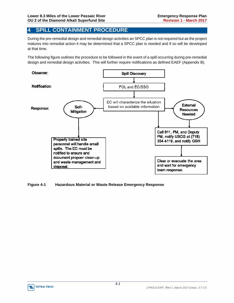
Lower 8.3 Miles of the Lower Passaic River Emergency Response Plan OU 2 of the Diamond Alkali Superfund Site Revision 1 - March 2017
4-1 LPROU2-ERP_Rev 1_March 2017 (clean, 3-7-17)
4 SPILL CONTAINMENT PROCEDURE
During the pre-remedial design and remedial design activities an SPCC plan is not required but as the project matures into remedial action it may be determined that a SPCC plan is needed and if so will be developed at that time.
The following figure outlines the procedure to be followed in the event of a spill occurring during pre-remedial design and remedial design activities. This will further require notifications as defined EAEF (Appendix B).
Figure 4-1 Hazardous Material or Waste Release Emergency Response

Lower 8.3 Miles of the Lower Passaic River Emergency Response Plan OU 2 of the Diamond Alkali Superfund Site Revision 1 - March 2017
5-1 LPROU2-ERP_Rev 1_March 2017 (clean, 3-7-17)
5 WEATHER EMERGENCIES
Local weather conditions will affect the drift and dispersion of chemical releases or smoke as well as all work conducted on water. The National Weather Service (NWS) web site will be checked to determine whether rainfall or severe weather hazards are expected and the potential wind speed and direction. The EC/SSO will monitor weather conditions daily or more frequently if needed. Shelters to be used in the event of a severe weather evacuation will be determined on a daily basis by the field crew and recorded on the EAEF.
Figure 5-1 Severe Weather Actions

Lower 8.3 Miles of the Lower Passaic River Emergency Response Plan OU 2 of the Diamond Alkali Superfund Site Revision 1 - March 2017
Appendix A LPROU2-ERP_Rev 1_March 2017 (clean, 3-7-17)
Appendix A—Emergency Contact Information

Lower 8.3 Miles of the Lower Passaic River Emergency Response Plan OU 2 of the Diamond Alkali Superfund Site Revision 1 - March 2017
A-1 LPROU2-ERP_Rev 1_March 2017 (clean, 3-7-17)
Emergency Contact List
ALWAYS DIAL 911 FIRST
Tetra Tech Project Management
Role Name and/or address Direct Line Cell Phone
Project Manager Steve McGee 440-522-6936
Deputy Project Manager Richard Feeney 973-630-8092
920-445-0732
201-650-1006
Health and Safety Lead (HSL) Tami Froelich, CIH, CSP 509-392-9080 509-372-5827
Field Operations Leader (FOL) To Be Determined (TBD)
Emergency Coordinator/Site Safety Officer (EC/SSO)
TBD
Field Technicians TBD
QA/QC Lead Lynn Arabia 973-630-8356 973-224-4359
EPA Project Coordinator
Role Name and/or address Direct Line Cell Phone
EPA Project Coordinator
Alice Yeh
U.S. EPA, Emergency & Remedial Response Div.
Region 2
290 Broadway
New York, NY 10007‐1866
212-637-4427 914-912-7293
Glenn Springs Holdings, Inc. Management
Role Name and/or address Direct Line Cell Phone
Project Coordinator Juan Somoano 713-215-7473 214-608-0168
Health & Safety Representative Enzo Conti 713-350-4744 214-608-6124
Hospitals
Facility Name Address Direct Phone
Dial 911 first
St. Michael’s Medical Center 111 Central Avenue, Newark, New Jersey
973-877-5000
Work Care Facilities
Facility Name Address Direct phone
TBD TBD TBD
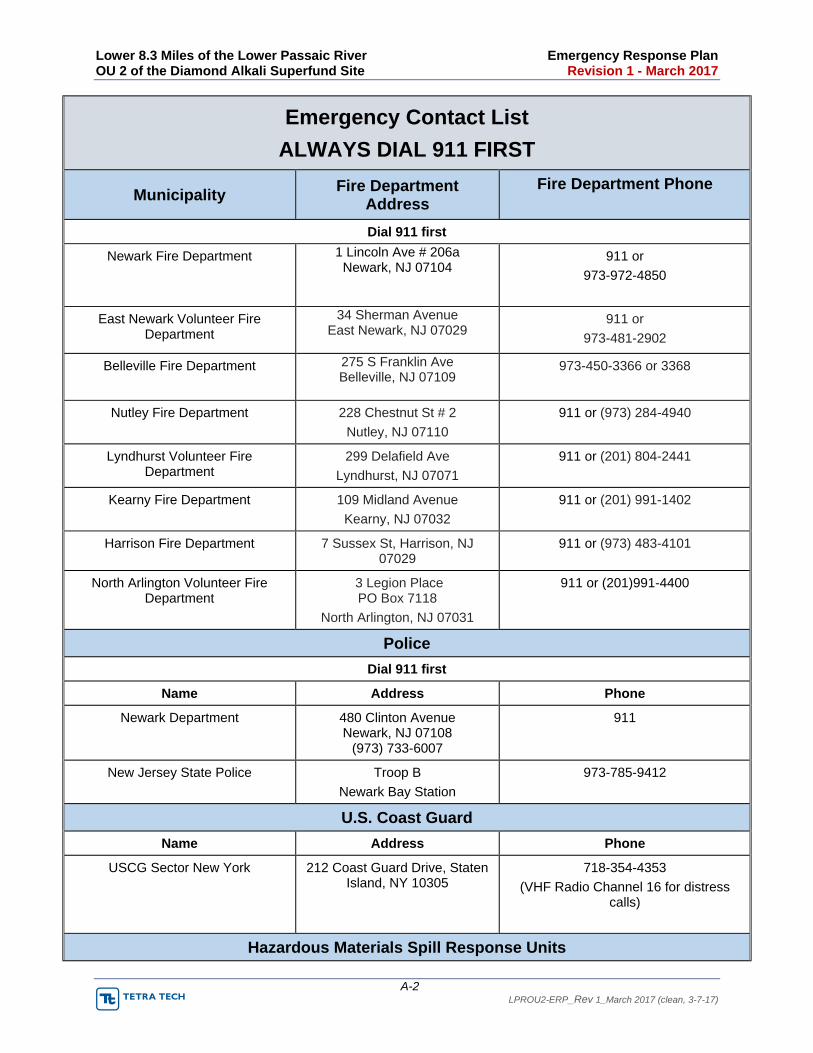
Lower 8.3 Miles of the Lower Passaic River Emergency Response Plan OU 2 of the Diamond Alkali Superfund Site Revision 1 - March 2017
A-2 LPROU2-ERP_Rev 1_March 2017 (clean, 3-7-17)
Emergency Contact List
ALWAYS DIAL 911 FIRST
Municipality Fire Department
Address Fire Department Phone
Dial 911 first
Newark Fire Department 1 Lincoln Ave # 206a Newark, NJ 07104
911 or
973-972-4850
East Newark Volunteer Fire Department
34 Sherman Avenue East Newark, NJ 07029
911 or
973-481-2902
Belleville Fire Department 275 S Franklin Ave Belleville, NJ 07109
973-450-3366 or 3368
Nutley Fire Department 228 Chestnut St # 2
Nutley, NJ 07110
911 or (973) 284-4940
Lyndhurst Volunteer Fire Department
299 Delafield Ave
Lyndhurst, NJ 07071
911 or (201) 804-2441
Kearny Fire Department 109 Midland Avenue
Kearny, NJ 07032
911 or (201) 991-1402
Harrison Fire Department 7 Sussex St, Harrison, NJ 07029
911 or (973) 483-4101
North Arlington Volunteer Fire Department
3 Legion Place PO Box 7118
North Arlington, NJ 07031
911 or (201)991-4400
Police
Dial 911 first
Name Address Phone
Newark Department 480 Clinton Avenue Newark, NJ 07108
(973) 733-6007
911
New Jersey State Police Troop B
Newark Bay Station
973-785-9412
U.S. Coast Guard
Name Address Phone
USCG Sector New York 212 Coast Guard Drive, Staten Island, NY 10305
718-354-4353
(VHF Radio Channel 16 for distress calls)
Hazardous Materials Spill Response Units

Lower 8.3 Miles of the Lower Passaic River Emergency Response Plan OU 2 of the Diamond Alkali Superfund Site Revision 1 - March 2017
A-3 LPROU2-ERP_Rev 1_March 2017 (clean, 3-7-17)
Emergency Contact List
ALWAYS DIAL 911 FIRST
Name Address Phone
Poison Control Center N/A 800-222-1222
National Response Center1 2100 2nd Street, Southwest – Room 2611
Washington, DC 20593-0001 USA
800-424-8802
202-267-2675
Footnote to Emergency Contact List:
1 - The National Response Center (NRC) maintains a 24 hours per day, 7 days a week, 365-days a year Operation Center where all information is received via the toll-free number, entered directly into an on-line data base system, and electronically disseminated as part of the National Response System. Once contacted, the NRC Duty Officer will guide the caller through a detailed series of questions based on the Standard Report Form to gather as
much information as possible concerning the spill or release. The information is immediately entered into the Incident Reporting Information System (IRIS) and based on several pre-established criteria including material involved, mode
of transportation, injuries, damage, and fatalities, select federal agency notification will take place within 15 minutes of receipt. When any of the following incidents occur, the NRC should immediately be contacted by the responsible party via the toll free number. If you see or discover and oil spill or release of chemicals and are NOT the responsible party,
you should contact the NRC with whatever information you have.
Chemical Releases
The Comprehensive Environmental Response, Compensation, and Liability Act requires that all releases of hazardous substances exceeding reportable quantities be reported by the responsible party to the National Response Center. Title 40 of the Code of Federal Regulations (CFR) Part 302 promulgates reportable quantities and reporting
criteria. All the Extremely Hazardous Chemicals (EHC) that overlaps with the CERCLA listed chemicals table (40CFR Part 302.4) should be reported to NRC.
Other Releases
Discharges from a hazardous waste treatment or storage facility must be reported by the emergency coordinator at the facility.

Lower 8.3 Miles of the Lower Passaic River Emergency Response Plan OU 2 of the Diamond Alkali Superfund Site Revision 1 - March 2017
Appendix B LPROU2-ERP_Rev 1_March 2017 (clean, 3-7-17)
Appendix B—Emergency Action and Evacuation Form

B-1 LPROU2-ERP_Rev 1_March 2017 (clean, 3-7-17)
Emergency Action and Evacuation Form (EAEF)
Date:
Project Name:
Completed by:
1. Municipality of work location
2. Nearest Docking Location_
3. Nearest Street to docking location
4. Assembly Point
5. Severe Weather Shelter Location:
a. b. c.
6. On shore Assembly Points:
a. b. c.
7. First Aid Kit Locations 8. AED Location_
9. Equipment Shutdown Procedure_
a. b.
10. Spill/Release Emergency Contact List See the Table on the following page.

B-2 LPROU2-ERP_Rev 1_March 2017 (clean, 3-7-17)
Contact Phone Number
Time Frame Release Notification Requirement
National Response Center
1-800-424-8802 As soon as possible, but no later than 12 hours
Transportation –related (including loading/unloading, and temporary storage) incidents involving hazardous materials (including hazardous wastes). Hazardous materials are listed under 49 CFR 172.101
As a direct result of hazardous material:
A person is killed,
A person receives an injury requiring admittance to a hospital.
The general public is evacuated for 1 hour or more; a major transportation artery or facility is closed or shut down for 1 hour or more or he operational flight pattern or routine of an aircraft is altered.
There has been a release of a marine pollutant in a quantity exceeding 119 gallons for liquids or 882 lbs. for solids.
Release of a hazardous substance equal to exceeding the Reportable Quantity (RQ) (see 40 CFR 302 – Table 302.4).
National Response Center (or if direct notification to the NRC is not practical, reports can be made to the USGS)
NRC: 1-800-424-8802 USGS District at (718) 354-4119
As soon as there is knowledge of the spill.
Report oil spills into or upon the navigable waters of the United States or adjoining shorelines.
Reportable discharges of oil include quantities that:
Violate applicable water quality standards
Cause a film or sheen upon or discoloration of the surface of
the water or adjoining shorelines
Cause a sludge or emulsion to be deposited beneath the surface of the water or upon adjoining shorelines
EPA Regional Office Region II
1-212-637-4040 Immediate reporting
Spills of 10 pounds or more by weight of PCBs (any concentration greater than 50 ppm). Spills of 1 pound or more by weight of PCBs (i.e., Total volume spilled times concentration > 1 pound) are also reportable to the National Response Center.
New Jersey Department of Environmental Protection
NJDEP HOTLINE 1-877-WARNDEP / 1-877-927-6337
Immediate reporting
All discharges to the environment of a hazardous substance (including petroleum products such as diesel, gasoline, oil)
except the following:
A discharge of gasoline or another petroleum product that is completely contained on an impervious surface.
A discharge of gasoline if < 1 gallon is discharged onto a surface that is not impervious or runs off an impervious surface.
A discharge of a petroleum product other than gasoline if < 5 gallons is discharged onto a surface that is not impervious or runs off an impervious surface.
A discharge of hazardous substances (e.g., PCBs) specifically listed in 40 CFR part 117 or 302 if the amount discharged in any 24 hour period is less than the RQ listed in 40 CFR part 117 or 302 (e.g., RQ for PCBs = 1 pound)

B-3 LPROU2-ERP_Rev 1_March 2017 (clean, 3-7-17)
11. Evacuation Routes
This phase of the OU 2 work is being conducted over an 8.3 mile area. The large work area requires the FOL to daily complete this EAEF form and determine the appropriate evacuation and access route daily and when the work location changes. The 8.3 mile Project is split into three areas based on work location the FOL will mark the evacuation route along with access, docking and evacuation locations.
Evacuation Map Area 1
Municipality of work location:
Nearest docking location:
Nearest street to docking location:
Evacuation assembly area:
Safe and severe weather shelter location:
On shore evacuation assembly area:

B-4 LPROU2-ERP_Rev 1_March 2017 (clean, 3-7-17)
Evacuation Map Area 2
Municipality of work location:
Nearest docking location:
Nearest street to docking location:
Evacuation assembly area:
Safe and severe weather shelter location:
On shore evacuation assembly area:

B-5 LPROU2-ERP_Rev 1_March 2017 (clean, 3-7-17)
Evacuation Map Area 3
Municipality of work location:
Nearest docking location:
Nearest street to docking location:
Evacuation assembly area:
Safe and severe weather shelter location:
On shore evacuation assembly area:
Lower 8.3 Miles of the Lower Passaic River Remedial Design Work Plan OU 2 of the Diamond Alkali Superfund Site Revision 2, March 2017
LPROU2‐RDWP_rev‐2_March 2017
Appendix B— Applicable or Relevant and Appropriate Requirements (ARARs)

Page 1 of 8
Appendix BApplicable or Relevant and Appropriate Requirements (ARARs)
Authority/Source General Description ARAR or TBC
Location-Specific ARARs or TBCs
Federal
Coastal Zone Management Act (CZMA), 16 U.S.C. §1451 et seq., CZMA § 307(a)(1) Coordination and cooperation
Coastal Zone Management Act Federal Consistency Regulations, 15 CFR Part 930: 15 CFR 930.30
The CZMA Federal Consistency Determination provisions require that any Federal agency undertaking a project in the coastal zone of a state shall insure that the project is, to the maximum extent practicable, consistent with the enforceable policies of approved state management programs. Applicable to dredging. Implemented through compliance with substantive requirements of New Jersey Waterfront Development Law and Coastal Zone Management Rules, N.J.A.C. 7:7.
ARAR Applicable
Section 10, Rivers & Harbors Act of 1899, 33 U.S.C. § 403 33 CFR Parts 322, 323, 329
Governs coordination of activities occurring in navigable waters. Congressional approval required for any obstruction of the navigable capacity of the waters of the United States. Construction of bridges, wharfs, piers, and other structures across navigable waters must be authorized by U.S. Army Corps of Engineers (USACE). The creation of any obstruction not affirmatively authorized by Congress, to the navigable capacity of any of the waters of the United States is prohibited; and it shall not be lawful to build or commence the building of any wharf, pier, dolphin, boom, weir, breakwater, bulkhead, jetty, or other structures in any port, roadstead, haven, harbor, canal, navigable river, or other water of the United States, outside established harbor lines. Placement of pilings, or discharge of dredged material where the flow or circulation of waters of the United States may be impaired or the reach of such waters reduced must comply with Section 10.
ARAR Applicable
33 CFR 322.2.(b) addresses the alteration of any navigable water of the United States, including “the excavating from or depositing of material in such waters, or the accomplishment of any other work affecting the course, location, condition, or capacity of such waters.”
33 CFR 322(e) provides that placing aids to navigation in navigable waters is under the purview of Section 10, and must meet requirements of the U.S. Coast Guard (33 CFR 330.5(a)(1)).
33 CFR 323.3 contains requirements for discharges of dredged or fill material into water of the United States, as those terms are defined in 33 CFR 323.2.
33 CFR Section 323.4(b) provides that If any discharge of dredged or fill material contains any toxic pollutant listed under section 307 of the CWA such discharge shall require compliance with Section 404 of the CWA.
33 CFR 329.4 defines the term “navigable water of the United States” for purposes of the USACE regulations, including those addressing the discharge of dredged or fill material.

Page 2 of 8
Authority/Source General Description ARAR or TBC
Endangered Species Act, 16 U.S.C. §1531 et seq.
The Endangered Species Act provides broad protection for species of fish, wildlife and plants that are listed as threatened or endangered in the U.S. or elsewhere. Applicable if any action may have an impact on an endangered species listed in 50 CFR Part 17.11(h). The federally endangered peregrine falcon has been observed in the lower 8.3 mile area. The shortnose sturgeon and Atlantic sturgeon are federally listed as endangered. The shortnose sturgeon was not collected in any of the studies conducted in Newark Bay or adjacent waters. The Atlantic sturgeon formerly inhabited the Passaic River. National Marine Fisheries Services (NMFS) collected an Atlantic sturgeon in Newark Bay in 1993/94 but has not been collected in any of the Passaic River studies.
ARAR Potentially Applicable
50 CFR Part 17, Subpart I, Part 402 including 50 CFR Part 17.21(c) 50 CFR Part 17.31(a)
National Historic Preservation Act (NHPA), 16 U.S.C. §470 et seq.
The NHPA requires federal agencies to take into account the effects of any federally assisted undertaking on any district, site, building, structure or object included in, or eligible for inclusion in, the National Register of Historic Places. If the undertaking results in adverse effects, the agency must consult with the New Jersey Historic Preservation Office and other parties to develop ways to avoid, reduce, minimize, or mitigate any adverse impacts to those identified properties. A side-scan sonar survey performed in the Lower Passaic River in 2004 identified large objects including automobiles and a shipwreck. EPA expects to conduct a cultural survey (Phase I and II) during remedial design that would comply with the NHPA and aid in consultations with the New Jersey Historic Preservation Office.
ARAR Applicable
Protection of Historic Properties, 36 CFR. Part 800
Floodplain Management: Executive Order 11988 as amended by Executive Order 13690
Directs federal agencies to evaluate the potential effects of actions that may be taken in a floodplain and to avoid, to the extent possible, long-term and short-term adverse effects associated with the occupancy and modification of floodplains, and to avoid direct or indirect support of floodplain development wherever there is a practicable alternative. The selected remedy includes enough dredging so that the engineered cap can be placed without increasing the potential for flooding. EPA does not expect the elevation of the river bottom or the mudflats to be increased above current conditions.
TBC
Protection of Wetlands, Executive Order 11990
Directs that activities conducted by federal agencies avoid, to the extent possible, long- term and short-term adverse effects associated with the modification or destruction of wetlands. Federal agencies are to avoid direct or indirect support of new construction in wetlands when there are practical alternatives; harm to wetlands must be minimized when there is no practical alternative available. These considerations are applicable to any remedial work in wetlands. The aquatic habitat affected by the selected remedy will be replaced with habitat of similar size and location, but significantly improved quality.
TBC
Fish and Wildlife Coordination Act, 16 U.S.C. § 662, 40 CFR 6.302(g).
Requires consideration of the effects of a proposed action on wetlands and areas affecting streams (including floodplains), as well as other protected habitats. Federal agencies must consult with the United States Fish and Wildlife Service (USFWS) and the appropriate state agency with jurisdiction over wildlife resources prior to issuing permits or undertaking actions involving the modification of any body of water (including impoundment, diversion, deepening, or otherwise controlled or modified for any purpose). Consultation with USFWS will occur during remedial design.
ARAR Applicable
Magnuson-Stevens Fishery Conservation and Management Act, 16 U.S.C. 1801, as amended through October 11, 1996
Requires that federal agencies consult with NMFS on actions that may adversely affect essential fish habitat (EFH), defined as “those waters and substrate necessary to fish for spawning, breeding, feeding, or growth to maturity.” NMFS has designated the Lower Passaic River as EFH for a number of fish species and life stages. A fish migration study will be conducted during remedial design and consultation will occur with NMFS and the New Jersey Department of Environmental Protection (NJDEP) regarding fish windows.
ARAR Applicable

Page 3 of 8
Authority/Source General Description ARAR or TBC
Migratory Bird Treaty Act, 16 U.S.C. §703
Requires that federal agencies consult with USFWS during remedial design and remedial construction to ensure that the cleanup of the site does not unnecessarily impact migratory birds. Consultation with USFWS will occur during remedial design.
ARAR Applicable
State
New Jersey Soil Erosion and Sediment Control Act , N.J.S.A. 4:24-39, N.J.A.C. 2:90
Regulates construction that will potentially result in erosion of soils and sediment, such as at an upland processing facility, requires preparation of stormwater pollution prevention plan, designation of construction waste collection site, site plan for construction related erosion. Applicable to land disturbance activities involving greater than 5,000 square feet.
ARAR Potentially Applicable
New Jersey Freshwater Wetlands Protection Act, N.J.S.A. 13:9B-1,N.J.A.C. 7:7A
Regulates construction or other activities (including remedial action) that will have an impact on wetlands, including working and transporting across coastal zone to upland processing facility. As described in the Remedial Investigation/Focused Feasibility Study Appendix F, Best Management Practices will be used during implementation of the selected remedy to avoid or minimize adverse impact to aquatic habitat, consistent with substantive requirements of N.J.A.C. 7:7A.
ARAR Applicable
New Jersey Flood Hazard Area Control Act, N.J.S.A. 58:16A-50, N.J.A.C. 7:13
Regulates activities (including remedial action) within flood hazard areas that will impact stream carrying capacity or flow velocity to avoid increasing impacts of flood waters, to minimize degradation of water quality, protect wildlife and fisheries, and protect and enhance public health and welfare.
Consistent with N.J.A.C. 7:13-10 and 7:13-11, EPA does not expect the elevation of the river bottom or the mudflats to be increased above current conditions. Potentially applicable to construction of upland processing facility depending on location.
ARAR Potentially Applicable
New Jersey Tidelands Act, N.J.S.A. 12:3 (Riparian Lands, Leases, Grants and Conveyances Act)
Requires a tidelands lease, grant or conveyance for use of State-owned riparian lands, including sediment removal and backfill. Tidelands, also known as riparian lands, are all those lands now or formerly flowed by the mean high tide of a natural waterway, except for those lands for which the State has already conveyed its interest in the form of a riparian grant. Applicable to dredging and capping. Substantive requirements include preparation of plans by professional engineer, depicting the limits of the tidelands instrument, notice to upland property owners.
ARAR Applicable
New Jersey Waterfront Development Law, N.J.S.A. 12:5-3, New Jersey Coastal Zone Management Rules, N.J.A.C. 7:7
Regulates any waterfront development, including sediment removal and fill, at or below mean high water and up to 500 feet from mean high water in the coastal zone and tidal waters of the State. Implemented through Coastal Zone Management Rules (N.J.A.C. 7:7), which provide rules and standards for use and development of resources in New Jersey’s coastal zone. The rules are used in the review of water quality certificates subject to Section 401 of the Federal Clean Water Act, and Federal consistency determinations under Section 307 of the Federal Coastal Zone Management Act, 16 U.S.C. § 1456. The rules also provide a basis for riparian grants, leases, and licenses. Potentially applicable to construction of upland processing facility.
ARAR Applicable
New Jersey Register of Historic Places Act N.J.S.A. 13:1B-15.128 et seq.
If federally assisted undertaking on any district, site, building, structure or object included in, or eligible for inclusion in, the National Register of Historic Places results in adverse effects, the agency must consult with the New Jersey Historic Preservation Office and other parties to develop ways to avoid, reduce, minimize, or mitigate any adverse impacts to those identified properties. EPA expects to conduct a cultural survey (Phase I and II) during remedial design that would comply with the NHPA and aid in consultations with the New Jersey Historic Preservation Office.
ARAR Potentially Applicable

Page 4 of 8
Authority/Source General Description ARAR or TBC
Action-Specific ARARs
Federal
Clean Water Act (CWA), 33 U.S.C. §1251, et seq.
Provides authority for EPA to establish water quality criteria for the protection of aquatic life and human health. New Jersey has promulgated surface water quality criteria.
Federally recommended water quality criteria established under Section 304(a) of the CWA that are more stringent than state criteria may be relevant and appropriate. Note that the selected remedy is not a final action for the water column.
ARAR Relevant and Appropriate CWA §§ 303, 304(a)
40 CFR Parts 129, 131 Specific toxic pollution effluent standards that may apply: Aldrin/Dieldrin 129.4(a), DDT 129.4(b), PCBs 129.4(f)
Clean Water Act, §401 40 CFR §121.2
Requires that an applicant for a federal license or permit provide a certification that any discharges (e.g., dredged material dewatering effluent, placement of fill, discharges of decants water) will comply with the Act, including water quality standard requirements (water quality certification). Dredging and capping must comply with substantive requirements in N.J.A.C. 7:7 (discussed above) which is basis for issuance of water quality certification in New Jersey.
ARAR Applicable
Clean Water Act, §404 40 CFR Part 230 (Guidelines for Specification of Disposal Sites for Dredged or Fill Material)
40 CFR 320-330 (discussed above under location-specific ARARs)
Regulates the discharge of dredged and fill material into waters of the United States including wetlands and including return flows from such activity. This program is implemented through regulations set forth in the 404(b)(1) guidelines, 40 CFR Part 230. The guidelines specify the types of information and environmental conditions that need to be evaluated for impacts on the aquatic ecosystem and provide for compensatory mitigation when there will be unavoidable impacts to waters of the United States.
40 CFR Part 230.10(a) Restrictions on Discharge (approach minimizes adverse environmental consequences).
40 CFR Part 230.10(b) (approach does not causes or contributes, after consideration of disposal site dilution and dispersion, to violations of any applicable s tate water quality standard).
40 CFR Part 230.10(c) (discharge will not cause or contribute to significant degradation of the waters of the United States).
40 CFR Part 230.10(d) (take appropriate and practicable steps in accordance with 40 CFR 230.70 to minimize potential adverse impacts of the discharge on the aquatic ecosystem);
40 CFR 230.11 (determine potential short-term or long-term effects of the discharge of dredged or fill material on the physical, chemical, and biological components of the aquatic environment). Consistent with CWA § 404(b)(1) and Part 230, an evaluation prepared as part of the RI/FFS and provided in Appendix F describes the Best Management Practices and engineering practices that will be used during implementation of the selected remedy to avoid or minimize adverse impacts to aquatic habitat The aquatic habitat affected by the remedy will be replaced with habitat of similar size and location, but significantly improved quality, so no additional mitigation is anticipated.
ARAR Applicable
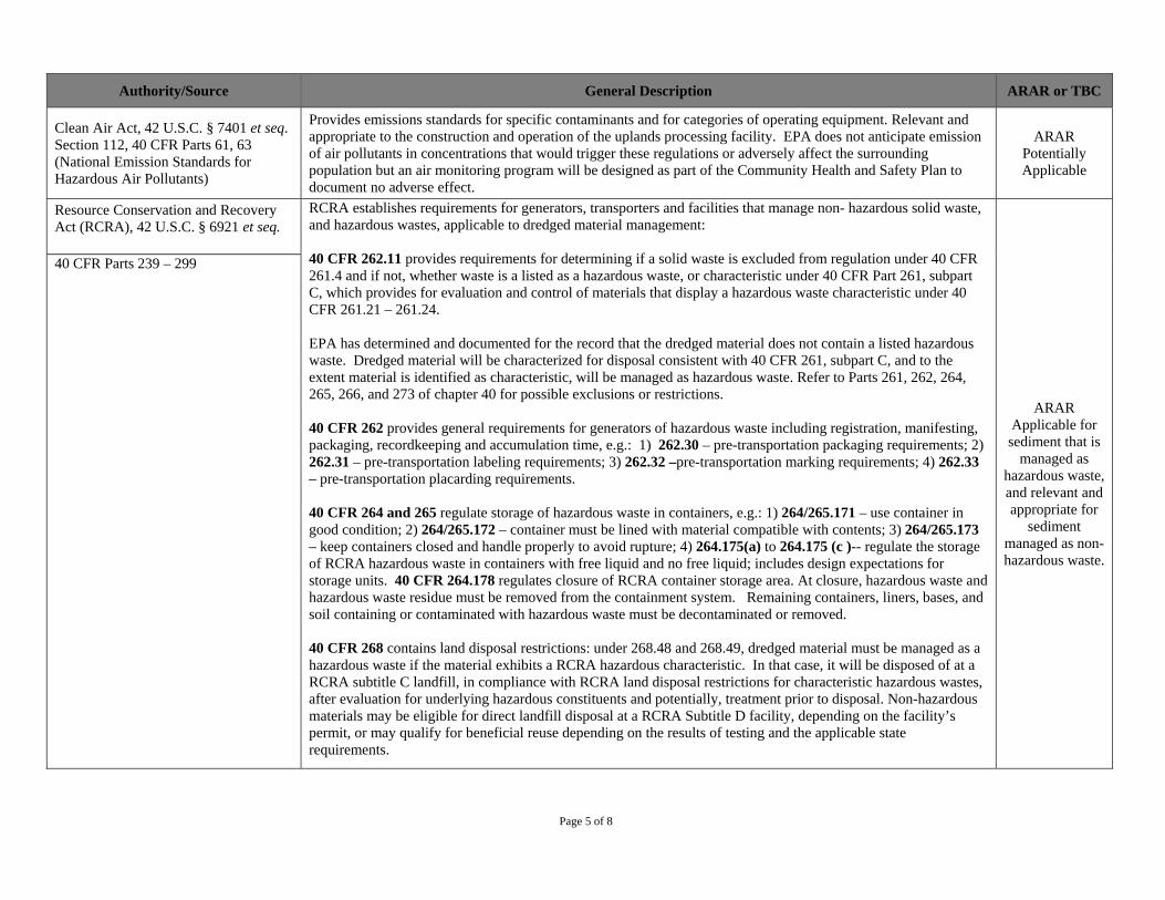
Page 5 of 8
Authority/Source General Description ARAR or TBC
Clean Air Act, 42 U.S.C. § 7401 et seq. Section 112, 40 CFR Parts 61, 63 (National Emission Standards for Hazardous Air Pollutants)
Provides emissions standards for specific contaminants and for categories of operating equipment. Relevant and appropriate to the construction and operation of the uplands processing facility. EPA does not anticipate emission of air pollutants in concentrations that would trigger these regulations or adversely affect the surrounding population but an air monitoring program will be designed as part of the Community Health and Safety Plan to document no adverse effect.
ARAR Potentially Applicable
Resource Conservation and Recovery Act (RCRA), 42 U.S.C. § 6921 et seq.
RCRA establishes requirements for generators, transporters and facilities that manage non- hazardous solid waste, and hazardous wastes, applicable to dredged material management:
40 CFR 262.11 provides requirements for determining if a solid waste is excluded from regulation under 40 CFR 261.4 and if not, whether waste is a listed as a hazardous waste, or characteristic under 40 CFR Part 261, subpart C, which provides for evaluation and control of materials that display a hazardous waste characteristic under 40 CFR 261.21 – 261.24.
EPA has determined and documented for the record that the dredged material does not contain a listed hazardous waste. Dredged material will be characterized for disposal consistent with 40 CFR 261, subpart C, and to the extent material is identified as characteristic, will be managed as hazardous waste. Refer to Parts 261, 262, 264, 265, 266, and 273 of chapter 40 for possible exclusions or restrictions.
40 CFR 262 provides general requirements for generators of hazardous waste including registration, manifesting, packaging, recordkeeping and accumulation time, e.g.: 1) 262.30 – pre-transportation packaging requirements; 2) 262.31 – pre-transportation labeling requirements; 3) 262.32 –pre-transportation marking requirements; 4) 262.33 – pre-transportation placarding requirements.
40 CFR 264 and 265 regulate storage of hazardous waste in containers, e.g.: 1) 264/265.171 – use container in good condition; 2) 264/265.172 – container must be lined with material compatible with contents; 3) 264/265.173 – keep containers closed and handle properly to avoid rupture; 4) 264.175(a) to 264.175 (c )-- regulate the storageof RCRA hazardous waste in containers with free liquid and no free liquid; includes design expectations for storage units. 40 CFR 264.178 regulates closure of RCRA container storage area. At closure, hazardous waste and hazardous waste residue must be removed from the containment system. Remaining containers, liners, bases, and soil containing or contaminated with hazardous waste must be decontaminated or removed.
40 CFR 268 contains land disposal restrictions: under 268.48 and 268.49, dredged material must be managed as a hazardous waste if the material exhibits a RCRA hazardous characteristic. In that case, it will be disposed of at a RCRA subtitle C landfill, in compliance with RCRA land disposal restrictions for characteristic hazardous wastes, after evaluation for underlying hazardous constituents and potentially, treatment prior to disposal. Non-hazardous materials may be eligible for direct landfill disposal at a RCRA Subtitle D facility, depending on the facility’s permit, or may qualify for beneficial reuse depending on the results of testing and the applicable state requirements.
ARAR Applicable for sediment that is
managed as hazardous waste, and relevant and appropriate for
sediment managed as non-hazardous waste.
40 CFR Parts 239 – 299
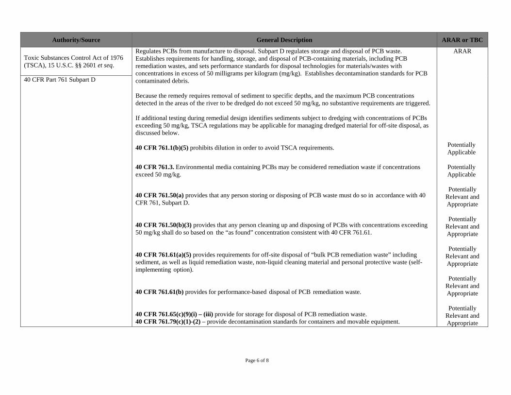
Page 6 of 8
Authority/Source General Description ARAR or TBC
Toxic Substances Control Act of 1976 (TSCA), 15 U.S.C. §§ 2601 et seq.
Regulates PCBs from manufacture to disposal. Subpart D regulates storage and disposal of PCB waste. Establishes requirements for handling, storage, and disposal of PCB-containing materials, including PCB remediation wastes, and sets performance standards for disposal technologies for materials/wastes with concentrations in excess of 50 milligrams per kilogram (mg/kg). Establishes decontamination standards for PCB contaminated debris.
Because the remedy requires removal of sediment to specific depths, and the maximum PCB concentrations detected in the areas of the river to be dredged do not exceed 50 mg/kg, no substantive requirements are triggered.
If additional testing during remedial design identifies sediments subject to dredging with concentrations of PCBs exceeding 50 mg/kg, TSCA regulations may be applicable for managing dredged material for off-site disposal, as discussed below.
40 CFR 761.1(b)(5) prohibits dilution in order to avoid TSCA requirements.
40 CFR 761.3. Environmental media containing PCBs may be considered remediation waste if concentrations exceed 50 mg/kg.
40 CFR 761.50(a) provides that any person storing or disposing of PCB waste must do so in accordance with 40 CFR 761, Subpart D.
40 CFR 761.50(b)(3) provides that any person cleaning up and disposing of PCBs with concentrations exceeding 50 mg/kg shall do so based on the “as found” concentration consistent with 40 CFR 761.61.
40 CFR 761.61(a)(5) provides requirements for off-site disposal of “bulk PCB remediation waste” including sediment, as well as liquid remediation waste, non-liquid cleaning material and personal protective waste (self-implementing option).
40 CFR 761.61(b) provides for performance-based disposal of PCB remediation waste.
40 CFR 761.65(c)(9)(i) – (iii) provide for storage for disposal of PCB remediation waste. 40 CFR 761.79(c)(1)-(2) – provide decontamination standards for containers and movable equipment.
ARAR
Potentially Applicable
Potentially Applicable
Potentially Relevant and Appropriate
Potentially Relevant and Appropriate
Potentially Relevant and Appropriate
Potentially Relevant and Appropriate
Potentially Relevant and Appropriate
40 CFR Part 761 Subpart D

Page 7 of 8
Authority/Source General Description ARAR or TBC
Hazardous Material Transportation Act, 49 U.S.C. §§ 1801-1819 Applicable to the transportation of dredged material that is being managed as hazardous wastes, and include the
procedures for the packaging, labeling, manifesting and transporting of hazardous materials to a licensed off- site disposal facility. General operating and handling requirements are outlined in 49 CFR 174, including documentation, placarding rail car/trucks, absence of leaking packages.
ARAR Applicable Hazardous Waste Transportation: 49
CFR Parts 171-177
State
New Jersey Water Pollution Control Act, N.J.S.A. 58:10A, et seq., New Jersey Water Quality Planning Act, N.J.S.A 58:11 A, et seq. New Jersey Surface Water Quality Standards, N.J.A.C. 7:9B
Establishes the designated uses and antidegradation categories of New Jersey’s surface waters, classifies surface waters based on those uses (i.e., stream classifications), and specifies the water quality criteria and other policies and provisions necessary to attain those designated uses. Used by New Jersey in setting discharge limits, for upland processing facility.
For dredging, N.J.A.C. 7:9B is applicable to evaluate impacts to surface water quality, for issuance of Water Quality Certificate. Will likely result in best management practices and monitoring to evaluate impact on surface water quality and downstream locations.
ARAR Applicable
New Jersey Pollutant Discharge Elimination System N.J.A.C. 7:14A
Establishes effluent discharge standards to protect water quality. Applicable to establish substantive compliance with discharge limitations for discharges from upland processing facility. N.J.A.C. 7:14, Subchapter 12, Appendix B identifies effluent standards (for specified constituents) for remediation projects.
ARAR Applicable
Stormwater Management Rules, N.J.A.C. 7:8
Applicable for establishing the design and performance standards for stormwater management measures at the upland processing facility.
ARAR Applicable
Noise Control, N.J.S.A., §13:1g-1 et seq., N.J.A.C. 7:20
Regulates noise levels for certain types of activities and facilities such as commercial, industrial, community service and public service facilities. Relevant and appropriate for establishing allowable noise levels. A noise monitoring program will be designed as part of the Community Health and Safety Plan.
ARAR Relevant and Appropriate
New Jersey Air Pollution Control Act, N.J.S.A. § 26:2C et seq., N.J.A.C. 7:27
Governs emissions that introduce contaminants into the ambient atmosphere for a variety of substances and from a variety of sources; controls and prohibits air pollution, particle emissions and toxic VOC emissions. EPA does not anticipate emission of air pollutants in concentrations that would trigger these regulations or adversely affect the surrounding population but an air monitoring program will be designed as part of the Community Health and Safety Plan to document no adverse effect.
ARAR Potentially Applicable

Page 8 of 8
Authority/Source General Description ARAR or TBC
New Jersey Solid Waste Management Act (NJSWMA), N.J.S.A. §13:1E-1, et seq., New Jersey Solid and Hazardous Waste Rules, N.J.A.C. 7:26 and 7:26G
New Jersey program for solid waste management and disposal pursuant to NJSWMA with regulations codified at N.J.A.C. 7:26 providing the requirements for solid waste disposal facilities. On September 14, 1998, EPA granted New Jersey full program determination of adequacy for all areas of its municipal solid waste landfill program.
N.J.A.C. 7:26-2.11(b)(9), facilities must comply with their operating permits, including acceptance criteria for waste. Non-hazardous material must meet the acceptance criteria of the receiving facility.
N.J.A.C. 7:26-1.6(a)(5), dredged material from New Jersey’s coastal or tidal waters, which is regulated under the New Jersey Water Pollution Control Act, New Jersey Waterfront Development Law, New Jersey Tidelands Act, Federal Clean Water Act and Federal Coastal Zone Management Act, is excluded from the definition of solid waste and thus not subject to disposal as solid waste in New Jersey. Dredged material, therefore, will not be disposed of as solid waste in New Jersey.
New Jersey hazardous waste management rules incorporate RCRA regulations by reference, with few significant differences. There are no disposal facilities located in New Jersey licensed to accept hazardous waste (RCRA Subtitle C).
ARAR Applicable
New Jersey Technical Requirements for Site Remediation, May 2012, N.J.A.C. 7:26E
Establish technical requirements for investigation and remediation processes under New Jersey cleanup programs. Substantive requirements for remedial action potentially relevant and appropriate to upland facility.
ARAR Potentially
Relevant and Appropriate
Notes:
ARAR - applicable or relevant and appropriate requirements CFR - Code of Federal Regulations; N.J.A.C. - New Jersey Administrative Code N.J.S.A. – New Jersey Statutes Annotated TBC - to-be-considered U.S.C. – United States Code