Embed Size (px)
Citation preview

GRC Transactions, Vol. 29, 2005
331
KeywordsGeothermal resources, GPS, Great Basin, Nevada, strain, tectonics, geodesy, exploration
ABSTRACT
The Great Basin is characterized by non-magmatic geother-mal fields, which we hypothesize are created, sustained, and controlled by active tectonics. In the Great Basin, GPS-mea-sured rates of tectonic "transtensional" (shear plus dilatational) strain rate is correlated with geothermal well temperatures and the locations of known geothermal fields. This has led to a conceptual model in which non-magmatic geothermal systems are controlled by the style of strain, where shear (strike-slip faulting) and extension (normal faulting) both play key roles. Specifically, shear stress is required to continuously fracture fault planes through the entire crust; whereas dilatational stress tends to pull fault planes apart. The combination of shear and dilatation can thus create fluid conduits to great depths, and then sustain them through continued stressing. Furthermore, Basin and Range (B&R) crust must have been thinned by di-latational strain, thus enhancing heat flow from the Moho to the Earth's surface. Assuming the thickness of B&R crust has since achieved dynamic equilibrium, we propose that crustal thickness is sustained by magmatic injection into the lower crust. In late 2003 we discovered such a lower-crustal event be-neath Lake Tahoe using GPS, thus confirming this mechanism occurs in the Great Basin. Dilatational stressing of the crust will tend to increase the rate of lower-crustal magmatic events, which can collectively enhance heat flow at depth through ad-vection. Given the higher geothermal favorability where both dilatational and shear strain are present, in the Great Basin this would point to the northern Walker Lane (NW Great Basin) and at the transition between strike-slip and normal faulting regimes in the Central Nevada Seismic belt to the east (e.g., the Stillwater Range), and the zone of strain partitioning adjacent to the Sierran front to the west (e.g., Honey Lake). To further develop this conceptual model for geothermal exploration re-
quires that strain be mapped on the scale of crustal thickness. For this purpose, in 2004 we installed a 60-station GPS net-work with a spacing of 15-30 km. This network "MAGNET" (Mobile Array of GPS for NEvada Transtension) spans the targeted region of high favorability. By late 2006, strain rates will be of sufficient accuracy for modeling and interpretation. Considering that strain-generating processes might have dif-ferent characteristic time scales, we plan to model post-seismic visco-elastic relaxation from large 20th century earthquakes in the region, which may dominate the strain rate field in specific areas, including Dixie Valley.
IntroductionWe present initial findings of a new geodetic method to
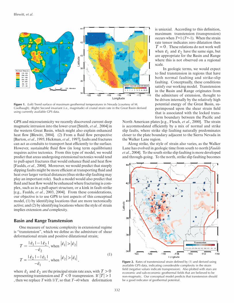
target potential geothermal resources in the Great Basin. Our objective is to seek relationships between geologic structures and GPS-geodetic observations of regional tectonic strain. Our driving scientific question is: “How do we explain so much geothermal activity within the largely non-magmatic setting of the Great Basin?” This is motivated by the observation [Blewitt, et al., 2002] that, on a regional scale, the locations of existing economic and sub-economic geothermal fields together with the spatial pattern of geothermal well temperatures is strongly correlated with GPS-measured rates of tectonic strain rate (Figure 1, overleaf). This suggests that geothermal plumbing systems might in some regions be controlled by fault planes acting as conduits that are continuously being fractured by tectonic activity [Blewitt, et al., 2003].
Conceptual ModelOur working conceptual model to explain geothermal
activity in non-magmatic settings is based on heat flow and fluid flow, and their interaction with tectonic activity. (1) GPS data show that the Basin and Range province is extending [Bennett, et al., 1999; Hammond and Thatcher, 2004], which would lead to crustal thinning. The shorter depth to Moho implies a regional enhancement in the thermal gradient. From
Relating Geothermal Resources to Great Basin Tectonics using GPS
Geoffrey Blewitt, William C. Hammond and Corné Kreemer
Great Basin Center for Geothermal EnergyNevada Bureau of Mines and Geology, and Nevada Seismological Laboratory
MS 178, University of Nevada, Reno
332
GPS and microseismicity we recently discovered current deep magmatic intrusion into the lower crust [Smith, et al., 2004] in the western Great Basin, which might also explain enhanced heat flow [Blewitt, 2004]. (2) From a fluid flow perspective [Barton, et al., 1995; Hickman, et al., 1997], faults and fractures can act as conduits to transport heat efficiently to the surface. However, sustainable fluid flow (in long term equilibrium) requires active tectonics. From this type of model, we would predict that areas undergoing extensional tectonics would tend to pull-apart fractures that would enhance fluid and heat flow [Faulds, et al., 2004]. Moreover, we would predict that steeply dipping faults might be more efficient at transporting fluid and heat over larger vertical distances (thus strike-slip faulting may play an important role). Such a model would also predict that fluid and heat flow would be enhanced where fracturing is com-plex, such as in a pull-apart structure, or a kink in fault-strike [e.g., Faulds, et al., 2003, 2004]. From these considerations, our objective is to use GPS to test aspects of this conceptual model, (1) by identifying locations that are more tectonically active; and (2) by identifying locations where the style of strain implies extension and complexity.
Basin and Range TranstensionOne measure of tectonic complexity in extensional regime
is “transtension”, which we define as the admixture of shear deformational strain and positive dilatational strain;
T = −−
| | | |ε εε
1 2
2, when
ε ε1 2>
T =−
−| | | |ε ε
ε2 1
1, when
ε ε2 1>,
(1)
where ε1 and ε2 are the principal strain rate axes, with T > 0 representing transtension and T < 0 transpression. If T > 1, then we replace T with 1/T, so that T→0 when deformation
is uniaxial. According to this definition, maximum transtension (transpression) occurs when T=1 (T=-1). When the strain rate tensor indicates zero dilatation then T = 0 . These relations do not work well when ε1 and ε2 have the same sign, but are appropriate for the Basin and Range where this is not observed on a regional scale.
In geologic terms, we would expect to find transtension in regions that have both normal faulting and strike-slip faulting. Conceptually, these conditions satisfy our working model. Transtension in the Basin and Range originates from the admixture of extension, thought to be driven internally by the relatively high potential energy of the Great Basin, su-perimposed upon the shear strain field that is associated with the locked trans-form boundary between the Pacific and
North American plates [e.g., Flesch, et al., 2000]. The strain is accommodated efficiently by a mix of normal and strike slip faults, where strike slip faulting naturally predominates closer to the plate boundary adjacent to the Sierra Nevada in the Walker Lane region.
Along strike, the style of strain also varies, as the Walker Lane has evolved in geologic time from south to north [Faulds et al., 2004]. To the south strike slip faulting is more developed and through-going. To the north, strike slip faulting becomes
Figure 1. (Left) Trend surface of maximum geothermal temperatures in Nevada [courtesy of M. Coolbaugh]. (Right) Second invariant (i.e., magnitude) of crustal strain rate in the Great Basin derived using currently available GPS data.
Figure 2. Rates of transtensional strain defined by (1) and derived using available GPS data, indicating considerable complexity in the strain field (negative values indicate transpression). Also plotted with stars are economic and sub-economic geothermal fields that are believed to be non-magmatic. Our conceptual model predicts that transtension should be a good indicator of geothermal potential.
Blewitt, et al.

333
more diffuse and complex. From this point of view, transten-sion in the northern Walker Lane is favored by our conceptual model for geothermal favorability.
Figure 2 shows an example of a GPS-determined map of transtension following (1) and based on currently available data, where it must be kept in mind that the GPS data are currently too sparse or too inaccurate to imply some of the mapped features, though this will be remedied with future data. The observed pattern of transtension is consistent with our current understanding of the tectonic setting. Such a map pro-vides essential guidance as to where future observations should be focused to produce more accurate, higher resolution maps of transtension as an indicator of geothermal potential.
MAGNET: Mobile Array of GPS for Nevada Transtension
In 2004 we began installing a new GPS network “MAG-NET” with the objective to map crustal strain rates with basin-scale (~15 km) spatial resolution, and 1 mm/yr accuracy. Network reconnaissance and siting, and GPS system design started September 2003, and data acquisition from the first few stations began in January 2004. To date (May 2005), 60 stations have been installed and measured using 34 GPS receivers that we move from site to site around the network. This network roughly spans a rectangular area across the northern Walker Lane and Central Nevada Seismic Belt from the Sierra Nevada in the west, out to Battle Mountain and Austin in the east. The network spans a broad region that has relatively high geothermal well temperatures, and is well poised to investigate crustal strain-rates around the economic geothermal fields at Brady’s/Desert Peak, and Dixie Valley. These GPS data will enable testing of the hypothesis that the controlling tectonic features that are favorable for geothermal targeting are abrupt changes in the strike of faults within the regional strain field. Examples of this include step-over ge-ometries in strike-slip faults which create pull-apart tectonics, or transtensional systems.
We estimate that the results from these GPS data will take 3–4 years before precise strain rate maps can be resolved with a precision of <1 mm/yr. A preliminary MAGNET GPS velocity field has been computed. These initial results from ~1 year of data acquisition indicate that the quality of the data is on target to meet this specification, with weekly station coordinate repeat-ability (1 standard deviation scatter) of 0.5 mm (horizontal) and 1.7 mm (vertical). By late 2006, strain rates of sufficient accuracy and spatial resolution are predicted to be at the level required to discriminate hypotheses from each test area regarding which structures are tectonically active, and to invert for tectonic pa-rameters that are relevant to geothermal models (such as the depth of locking and 3-d slip-rate vectors on active fault planes, which theoretically can be used to model dilatation around fault zones which might be accommodated by fracturing).
ModelingGiven highly precise GPS data together with geophysi-
cal modeling, the goal is to identify specific structures at the
basin scale which might be targeted for geothermal exploita-tion. Understanding post-seismic deformation is important so that we can calculate how much strain is really transient, and how much is secular on the geological time scale. For ex-ample, post-seismic viscoelastic relaxation following large 20th century earthquakes in the region likely dominates the strain rate field in specific areas, including Dixie Valley. Because we hypothesize that secular strain rate is important for geothermal activity (as crustal-scale heat flow is a long-term process), we present here some initial work to quantify the contribution of post-seismic deformation, such that it can be subsequently separated from the observed strain rates.
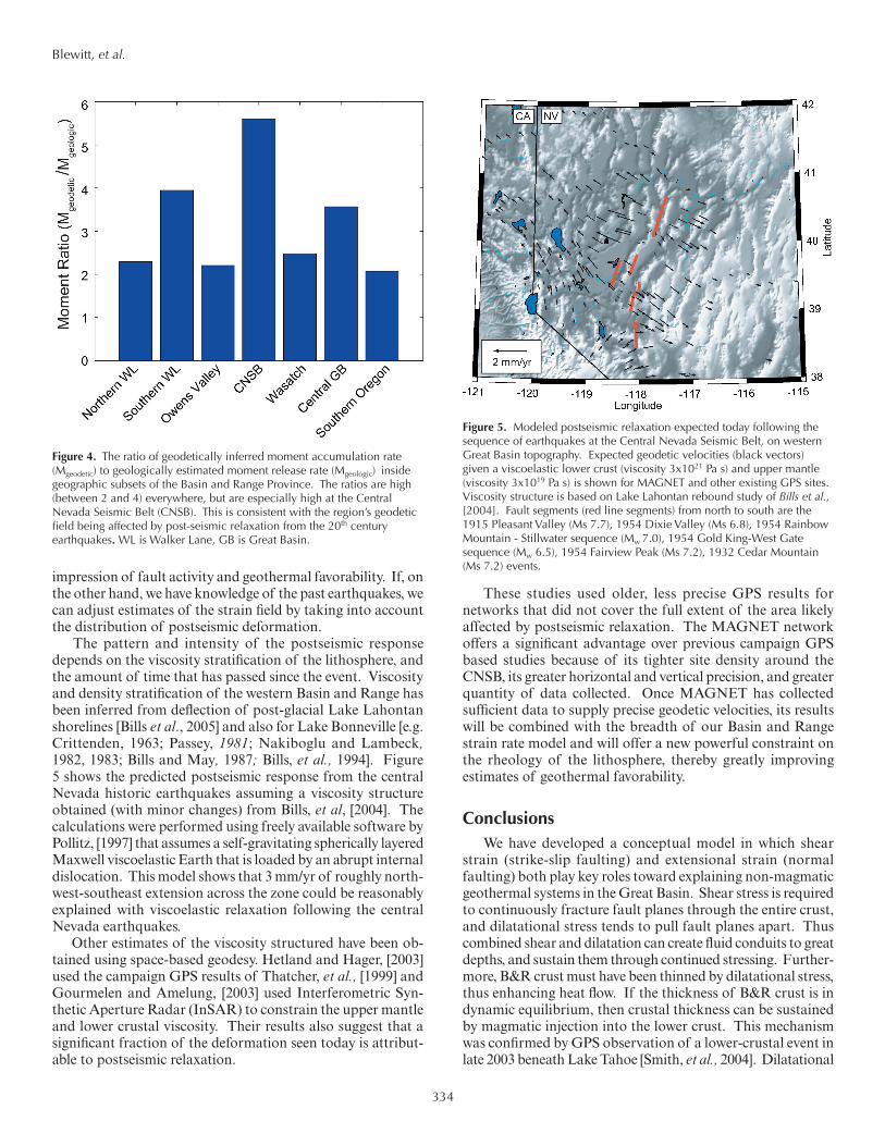
The presence of viscoelastic relaxation is supported by GPS surveys across the Central Nevada Seismic Belt, which show high rates of transtension, far greater than the rates inferred from paleoseismic investigations would suggest [Bell, et al., 2004], and greater than in adjacent areas. In this area the ratio of geodetic to geologic moment rates is higher than anywhere else in the Basin and Range (Figure 4, overleaf), consistent with the relaxation enhancing extension.
Great Basin Postseismic Relaxation and Estimating Geothermal Favorability
Because transient postseismic deformation does not repre-sent elastic loading of the seismogenic crust in the traditional sense, we expect its presence to perturb estimates of geothermal favorability. In particular, over time the deformation field from relaxation becomes broader and less localized near the fault of origin. Thus modern deformation up to hundreds of km from the past earthquake could be mistaken for seismogenic loading of faults far away from the earthquake, giving the false
����� ����� ����� ����� ����� �����
���
���
���� � � � � �� �� �� ��� ���
�����������������������������������������
�������������
���������
�����
���
Figure 3. Map of current GPS sites in the new network “MAGNET”. The greyscale contours indicate strain magnitude (not style). Without the GPS data from MAGNET, such strain maps would be too inaccurate to be useful for geothermal exploration, and so the above map should only be regarded as indicative of broader regional characteristics. By the end of 2006, strain-rate maps will become available with ~2 nstrain/yr accuracy, with ~20 km resolution, and will include the style of strain.
Blewitt, et al.
334
impression of fault activity and geothermal favorability. If, on the other hand, we have knowledge of the past earthquakes, we can adjust estimates of the strain field by taking into account the distribution of postseismic deformation.
The pattern and intensity of the postseismic response depends on the viscosity stratification of the lithosphere, and the amount of time that has passed since the event. Viscosity and density stratification of the western Basin and Range has been inferred from deflection of post-glacial Lake Lahontan shorelines [Bills et al., 2005] and also for Lake Bonneville [e.g. Crittenden, 1963; Passey, 1981; Nakiboglu and Lambeck, 1982, 1983; Bills and May, 1987; Bills, et al., 1994]. Figure 5 shows the predicted postseismic response from the central Nevada historic earthquakes assuming a viscosity structure obtained (with minor changes) from Bills, et al, [2004]. The calculations were performed using freely available software by Pollitz, [1997] that assumes a self-gravitating spherically layered Maxwell viscoelastic Earth that is loaded by an abrupt internal dislocation. This model shows that 3 mm/yr of roughly north-west-southeast extension across the zone could be reasonably explained with viscoelastic relaxation following the central Nevada earthquakes.
Other estimates of the viscosity structured have been ob-tained using space-based geodesy. Hetland and Hager, [2003] used the campaign GPS results of Thatcher, et al., [1999] and Gourmelen and Amelung, [2003] used Interferometric Syn-thetic Aperture Radar (InSAR) to constrain the upper mantle and lower crustal viscosity. Their results also suggest that a significant fraction of the deformation seen today is attribut-able to postseismic relaxation.
These studies used older, less precise GPS results for networks that did not cover the full extent of the area likely affected by postseismic relaxation. The MAGNET network offers a significant advantage over previous campaign GPS based studies because of its tighter site density around the CNSB, its greater horizontal and vertical precision, and greater quantity of data collected. Once MAGNET has collected sufficient data to supply precise geodetic velocities, its results will be combined with the breadth of our Basin and Range strain rate model and will offer a new powerful constraint on the rheology of the lithosphere, thereby greatly improving estimates of geothermal favorability.
ConclusionsWe have developed a conceptual model in which shear
strain (strike-slip faulting) and extensional strain (normal faulting) both play key roles toward explaining non-magmatic geothermal systems in the Great Basin. Shear stress is required to continuously fracture fault planes through the entire crust, and dilatational stress tends to pull fault planes apart. Thus combined shear and dilatation can create fluid conduits to great depths, and sustain them through continued stressing. Further-more, B&R crust must have been thinned by dilatational stress, thus enhancing heat flow. If the thickness of B&R crust is in dynamic equilibrium, then crustal thickness can be sustained by magmatic injection into the lower crust. This mechanism was confirmed by GPS observation of a lower-crustal event in late 2003 beneath Lake Tahoe [Smith, et al., 2004]. Dilatational
Figure 4. The ratio of geodetically inferred moment accumulation rate (Mgeodetic) to geologically estimated moment release rate (Mgeologic) inside geographic subsets of the Basin and Range Province. The ratios are high (between 2 and 4) everywhere, but are especially high at the Central Nevada Seismic Belt (CNSB). This is consistent with the region’s geodetic field being affected by post-seismic relaxation from the 20th century earthquakes. WL is Walker Lane, GB is Great Basin.
Figure 5. Modeled postseismic relaxation expected today following the sequence of earthquakes at the Central Nevada Seismic Belt, on western Great Basin topography. Expected geodetic velocities (black vectors) given a viscoelastic lower crust (viscosity 3x10²¹ Pa s) and upper mantle (viscosity 3x10¹⁹ Pa s) is shown for MAGNET and other existing GPS sites. Viscosity structure is based on Lake Lahontan rebound study of Bills et al., [2004]. Fault segments (red line segments) from north to south are the 1915 Pleasant Valley (Ms 7.7), 1954 Dixie Valley (Ms 6.8), 1954 Rainbow Mountain - Stillwater sequence (Mw 7.0), 1954 Gold King-West Gate sequence (Mw 6.5), 1954 Fairview Peak (Ms 7.2), 1932 Cedar Mountain (Ms 7.2) events.
Blewitt, et al.

335
stressing of the crust will tend to increase the rate of such magmatic events that can enhance heat flow at depth through advection. We therefore suggest that magma could indeed play a role in systems currently considered to be "non-magmatic", though the depth of magmatic activity and lack of regional volcanism may still be a useful distinguishing factor.
In conclusion, we predict high geothermal favorability where both dilatational and shear strain are present. In the Great Basin this would point to the northern Walker Lane (NW Great Basin) and at the transition between strike-slip and normal faulting regimes in the Central Nevada Seismic belt to the east (e.g., the Stillwater Range), and to the zone of strain partitioning on the margins of Sierran front to the west (e.g., Honey Lake). Specific geothermal targeting based on this approach will require improved strain resolution and accuracy from future GPS data sets, improved understanding of the various contributing processes to the observed strain accumulation, and further development of our working con-ceptual model. Toward this purpose we have installed a new 60-station GPS network in 2004, with a spacing of 15-30 km. This network, known as "MAGNET" (Mobile Array of GPS for NEvada Transtension), spans the targeted region of high favorability. By late 2006, strain rates of sufficient accuracy and spatial resolution are predicted to be at useful levels for improved modeling. One component of the model that requires attention is to understand and categorize the origin of observed strain, which might have different characteristic time scales. For example, we will test the hypothesis that post-seismic visco-elastic relaxation from large 20th century earthquakes in the region will dominate the strain rate field in areas such as Dixie Valley.
AcknowledgmentsThe authors thank Jim Faulds for providing useful sug-
gestions to improve the manuscript. We are indebted to Bret Pecoraro for diligently keeping the MAGNET network up and running continuously throughout the year. This work was funded by the Department of Energy through the Great Basin Center for Geothermal Energy.
ReferencesBarton, C.A., M.D. Zoback, and D. Moos, 1995. Fluid flow along poten-
tially active faults in crystalline rock: Geology, 23, 683-686.
Bell, J.W., S.J. Caskey, A.R. Ramelli, and L. Guerrieri, 2004, Pattern and rates of faulting in the Central Nevada Seismic Belt, and Paleoseismic evidence for prior belt-like behavior, Bull. Seismol. Soc. Am., 94 (4), 1229-1254.
Bennett, R.A., J.L. Davis, and B.P. Wernicke, B.P., 1999. Present-day pattern of Cordilleran deformation in the western United States, Geology, 27, 371-374.
Bills, B.G., D.R. Currey, and G.A. Marshall, 1994. Viscosity estimates for the crust and upper-mantle from patterns of shoreline deformation in the Eastern Great Basin, J. Geophys. Res., 99, 22,059-22,086.
Bills, B.G., and G.M. May, 1987. Lake Bonneville: Constraints on litho-spheric thickness and upper mantle viscosity from isostatic warping
of Bonneville, Provo and Gilbert stage shorelines, J. Geophys. Res., 92, 11,493-11,508.
Bills, B. G., Adams, K. A., Wesnousky, S. G., 2005, Viscosity structure of the crust and upper mantle in western Nevada from isostatic rebound patterns of Lake Lahontan shorelines, Geophys. J. Int., in press.
Blewitt, G., M. Coolbaugh, W.E. Holt, C. Kreemer, J.L. Davis, and R.A. Bennett, 2002. Targeting of potential geothermal resources in the Great Basin from regional relationships between geodetic strain and geological structures, Geothermal Resources Council Transactions, 26, 523-526.
Blewitt, G., M. Coolbaugh, W. Holt, J. Davis, and R. Bennett, 2003. Targeting of potential geothermal resources in the Great Basin from regional- to basin-scale relationships between geodetic strain and geological structures, Geothermal Resources Council Transactions, 27, 3-7.
Blewitt, G., 2004, Lower crustal transients and surface mass transport: Time series filtering for signal detection at two spatial extremes, Eos Trans., AGU 85(47), Fall Meet. Suppl., Abstract G51D-02.
Crittenden, M.D., 1963, Effective viscosity of the Earth derived from isostatic loading of Pleistocene Lake Bonneville, J. Geophys. Res., 68, 5517-5530.
Faulds, J.E., M. Coolbaugh, G. Blewitt, and C.D. Henry, 2004. Why is Nevada in hot water? Structural controls and tectonic model of geothermal systems in the northwestern Great Basin: Geothermal Resources Council Transactions, 28, 649-654.
Flesch, L. M., Holt, W. E., A. J. Haines, and B. Shen-Tu, 2000, Dynamics of the Pacific-North America plate boundary in the Western United States, Science, 287, 834-836.
Gourmelen, N., and F. Amelung, 2003. Anomalous crustal deformation in the Central Nevada Seismic Belt detected by InSAR, Eos Trans. AGU, 84 (46).
Hammond, W.C. and W. Thatcher, 2004, Contemporary tectonic defor-mation of the Basin and Range province, western United States: 10 years of observation with the Global Positioning System, J. Geophys. Res., 109, 8403, doi:10.1029/2003JB002746.
Hetland, E.A., and B.H. Hager, 2003, Postseismic relaxation across the Central Nevada Seismic Belt, J. Geophys. Res., 108 (B8), 2394, doi:10.1029/2002JB002257.
Hickman, S., C.A. Barton, M.D. Zoback, R. Morin, J. Sass, and R. Benoit, 1997, In situ stress and fracture permeability along the Still-water fault zone, Dixie Valley, Nevada: Int. J. Rock Mech. Mining Science, 34, 414.
Nakiboglu, S.M., and K. Lambeck, 1982, A study of the Earth's response to surface loading with application to Lake Bonneville, Geophys. J. R. Astron. Soc., 70, 577-620.
Nakiboglu, S.M., and K. Lambeck, 1983, A reevaluation of the isostatic rebound of Lake Bonneville, J. Geophys. Res., 88, 10439-10447.
Passey, Q.R., 1981, Upper mantle viscosity derived from the difference in rebound of the Provo and Bonneville shorelines: Lake Bonneville basain, Utah, J. Geophys. Res., 86, 11,701-11,708.
Pollitz, F.F., 1997, Gravitational-viscoelastic postseismic relaxation on a layered spherical Earth, J. Geophys. Res., 102, 17,921-17,941.
Smith, K.D., D. von Seggern, G. Blewitt, L. Preston, J.G. Anderson, B.P. Wernicke, J.L. Davis, 2004, Evidence for deep magma injection beneath Lake Tahoe, Nevada-California, Science, doi:10.1126/sci-ence.1101304.
Thatcher, W., G.R. Foulger, B.R. Julian, J.L. Svarc, E. Quilty, and G.W. Bawden, 1999, Present-Day Deformation Across the Basin and Range Province, Western United States, Science, 283, 1714-1718.
Blewitt, et al.

336