Embed Size (px)
Citation preview

4-1Reducing Damage from Localized Flooding: A Guide for Communities
Regulatory ToolsIn almost all cases, it is less expensive and less disruptive for a community to
prevent flood problems from occurring than to mitigate problems that already
exist. Regulatory tools can be designed to protect new buildings from flooding
and to prevent new development from creating new or aggravating existing flood
problems. The National Flood Insurance Program (NFIP) and its Community
Rating System (CRS) are good starting points for reviewing regulatory tools.
4To participate in the NFIP, communities are required to adopt and enforce regulations to manage new development in the Special Flood Hazard Area (SFHA) shown on the Flood Insurance Rate Map (FIRM). As noted in Chapter 2, significant damage can occur in the areas outside the SFHA in the B, C, and X Zones.
To prevent new development from making its localized flood problems worse, a community needs to do more than just enforce its NFIP regulations. The many regulatory tools that help minimize flooding and flood damage are discussed under the five main sections of this chapter:
Adopting a map showing additional flood-prone areas to be regulated;
Planning and zoning for appropriate development in flood-prone areas;
Setting standards for new subdivisions;
Setting standards for new buildings in flood-prone areas; and
Regulating site drainage.
A Regulatory Floodplain MapThe first step in managing new construction to protect it from flood damage is to determine what areas are subject to regulation. The NFIP has published the community’s FIRM, but this should be considered as only a beginning. The regulatory floodplain on the FIRM may not adequately identify all of a community’s at-risk

Reducing Damage from Localized Flooding: A Guide for Communities4-2
Chapter 4. Regulatory ToolsP A R T I I
areas. There are several reasons why some local flooding areas may be missing from the community’s FIRM.
Smaller problem areas do not show up as SFHAs because Federal Emergency Management Agency (FEMA) mapping standards focus on larger flood problems, such as watersheds larger than 1 square mile.
Conditions may have changed since the study was conducted to produce the FIRM, which could have been as long as 10 or 20 years ago.
When the FIRM was prepared, an area may not have been known to have a flood problem or it may not have had much development activity, so it was not studied.
The study criteria may not have reflected all types of flood-related hazards, such as land subsidence.
In short, FIRMs cannot be expected to show every flooding problem in the community, especially flooding caused by local drainage or storm sewer problems. However, because these problems are more frequent than the major flooding shown on the FIRM, and because the drainage or sewer system is a local responsibility, it is likely that the community has additional information that could be used to supplement the FIRM’s presentation of the community’s flood hazard.
Communities can do much to provide a better floodplain map and regulatory data. This section explains four valuable options for improvement:
Use more accurate elevation contour information to map flood elevations provided with the FIRM;
Restudy local flood-prone areas and produce a new regulatory floodplain map;
Require permit applicants to provide needed flood data; and
Develop new flood hazard maps and data using more exacting study techniques.
More Accurate Contour Map
When a community’s FIRM is prepared, the study contractor uses the best base map available at that time. In many cases, it could be a U.S. Geological Survey quadrangle map with a 5- or 10-foot contour interval. Since their FIRMs were prepared, many communities have developed geographic information systems (GIS), often with more recent and more accurate elevation data.
A community should check to see if there is a new base map with more accurate topography. This could be the product of recent surveying, analysis of ortho-rectified aerial photos, or light detection and ranging (LIDAR) (the use of an airborne laser
1.
2.
3.
4.
In Activity 410 (Additional Flood Data), the CRS encourages and provides credit for several map-ping activities:
Providing regulatory flood elevations in X and approximate A Zones;Restudying and remapping areas shown on the FIRM;Requiring developers to produce regulatory flood elevations in smaller watersheds; and Studying hydrology based on future water-shed conditions.
•
•
•
•

4-3Reducing Damage from Localized Flooding: A Guide for Communities
Chapter 4. Regulatory Tools P A R T I I
system to prepare topographic maps). Such a base map may have recently constructed roads, bridges, and other human-made features, 1- or 2-foot contour intervals, or contour information that is more accurate or more recent than that used to prepare the FIRM.
If there is a more accurate and more recent contour map, the 100-year flood elevations from the Flood Insurance Study’s flood profile should be plotted on it. Such an exercise may well reveal that the boundaries of the SFHA should be different. Gurnee, Illinois, found this to be true, as depicted in the adjacent map.
Many times, such a review finds that the FIRM understates the true inundated area and the SFHA should be extended into the X Zone. If this is the case, it is recommended that the community adopt this more accurate map in its floodplain management regulations.
Another approach is to record the high-water marks and note the areas flooded if a recent flood extended outside the boundaries of the SFHA. That is what the City of Conway, South Carolina, did after Hurricane Floyd sent the Waccamaw River flooding into its X Zone in 1999. The city adopted the area flooded by Floyd as its new regulatory floodplain (see page 4-5).
A third approach to capture more of the flood-prone areas is to regulate the mapped floodplain plus all areas 1 foot higher than the base flood elevation (BFE). Development on properties outside the SFHA, but within 1 foot of the BFE, would need a floodplain permit. If the developer produces accurate ground elevation data that show the building site above the BFE, the floodplain regulations would not apply.
A variation on this approach is to regulate to the next higher contour line. For example, a site located between a BFE of 145 and one of 146 would be mapped at the 146 contour line. A disadvantage of this method is that elevations are not increased by a constant amount (for example, 145.1 and 145.9 both round to 146).
New Flood Study
Using more recent or more accurate elevation data is a relatively inexpensive way to get a better flood map from existing flood data. Another approach to getting a new floodplain map is to conduct a new flood study
Gurnee, Illinois, put its FIRM flood elevations onto a more accurate base map and found these differences, identifying other areas that could be susceptible to flooding.
New Maps vs. FIRM
Adoption of a different map in the local or-dinance is allowed by the NFIP regulations, provided the new map covers a larger floodplain than the FIRM does. In fact, exceeding the NFIP minimum criteria is encouraged by FEMA. How-ever, two things should be noted:
The community’s map will not affect the cur-rent FIRM or alter the SFHA used for setting in-surance rates or making map determinations.Under 44 Code of Federal Regulations 65.3, as “soon as practicable, but not later than six months after the date such information becomes available, a community shall notify [FEMA] of the changes by submitting technical or scientific data….” The State NFIP Coordi-nator or the FEMA Regional Office should be contacted for instructions on how this is done (see contact list in Appendix A).
•
•
Reducing Damage from Localized Flooding: A Guide for Communities4-4
Chapter 4. Regulatory ToolsP A R T I I
to produce new flood data. The new study could either cover the same area mapped as SFHA on the FIRM or areas outside the SFHA that have been known to flood or have repetitive flood problems.
In the SFHA, the community’s new study must use the same or similar study techniques as for a detailed study on a FIRM. These techniques can be expensive, but the study may help with activities other than regulations. As noted in Chapters 8 and 10, a new flood study and watershed model can help greatly when planning drainage modifications or selecting a design protection level for a retrofitting project.
Typically, FIRMs do not include the floodplains of streams with a drainage area of less than 1.0 square mile in urban areas and even larger drainage areas in rural areas. Therefore, if there is a localized flood problem that should be mapped in order to guide development regulations, the area will most likely have to be studied by the community.
If the area is outside the SFHA, the community can use any technique it prefers. Areas not previously studied have no minimum standards. Probably the least-expensive approach is to use the flood of record, i.e., to map out the areas that were under water during the highest recorded flood. Communities that use this approach usually add a safety margin of a foot or two to the flood-of-record’s crest as the basis for a regulatory flood elevation.
It should be noted that using historical floods does not necessarily treat everyone the same. In some areas, the historical flood of record may be the 100-year flood, but in other parts of a community, it may be the 25-year flood. It is especially difficult to be consistent when some areas were developed in the last 10–20 years, so there is a relatively short history of known flood problems.
FEMA encourages a community to provide more accurate flood data to revise its FIRM. In fact, the Cooperating Technical Partners (CTP) program is a formal mechanism through which communities can cooperate on new flood studies or provide flood data that may differ from FEMA mapping criteria.
FEMA is working to prepare more new flood studies. Its Map Modernization Program has a goal of helping all communities update their FIRMs by the year 2008. Congress is allocating significant additional funding for these efforts. In other words, under the CTP program, FEMA wants to work more closely with communities to better delineate their flood hazard areas, and under Map Modernization, FEMA is expected to be able to increase its new study effort.
FEMA has also provided guidance and developed software to facilitate flood studies and reduce their cost. Managing Floodplain Development in Approximate Zone A Areas can be ordered from FEMA or downloaded from its Web
Cooperating Technical Partners
In conjunction with the Map Modernization Program, FEMA establishes partnerships with participating NFIP communities to collabo-rate in maintaining up-to-date flood maps and other flood hazard information through the CTP program. Under the CTP program, a community and FEMA work as partners to more efficiently and effectively update flood hazard maps. This ensures that local knowledge about flood prob-lems, local sources of data, and local preferenc-es for study priorities are all incorporated into the process. The CTP program brings funding for eligible activities, such as topographic data generation, hydrologic and hydraulic analyses, Digital FIRM (DFIRM) creation, and others. More information can be found at FEMA’s Web site at http://www.fema.gov/fhm/ctp_main.shtm.
4-5Reducing Damage from Localized Flooding: A Guide for Communities
Chapter 4. Regulatory Tools P A R T I I
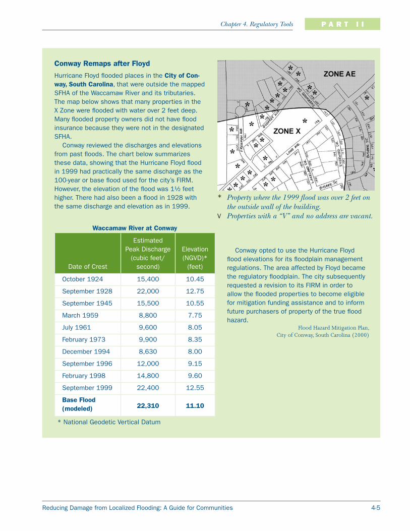
Conway Remaps after Floyd
Hurricane Floyd flooded places in the City of Con-way, South Carolina, that were outside the mapped SFHA of the Waccamaw River and its tributaries. The map below shows that many properties in the X Zone were flooded with water over 2 feet deep. Many flooded property owners did not have flood insurance because they were not in the designated SFHA.
Conway reviewed the discharges and elevations from past floods. The chart below summarizes these data, showing that the Hurricane Floyd flood in 1999 had practically the same discharge as the 100-year or base flood used for the city’s FIRM. However, the elevation of the flood was 1½ feet higher. There had also been a flood in 1928 with the same discharge and elevation as in 1999.
* Property where the 1999 flood was over 2 feet on the outside wall of the building.
V Properties with a “V” and no address are vacant.
Waccamaw River at Conway
Date of Crest
Estimated Peak Discharge
(cubic feet/second)
Elevation (NGVD)*
(feet)
October 1924 15,400 10.45
September 1928 22,000 12.75
September 1945 15,500 10.55
March 1959 8,800 7.75
July 1961 9,600 8.05
February 1973 9,900 8.35
December 1994 8,630 8.00
September 1996 12,000 9.15
February 1998 14,800 9.60
September 1999 22,400 12.55
Base Flood (modeled) 22,310 11.10
* National Geodetic Vertical Datum
Conway opted to use the Hurricane Floyd flood elevations for its floodplain management regulations. The area affected by Floyd became the regulatory floodplain. The city subsequently requested a revision to its FIRM in order to allow the flooded properties to become eligible for mitigation funding assistance and to inform future purchasers of property of the true flood hazard.
Flood Hazard Mitigation Plan,City of Conway, South Carolina (2000)

Reducing Damage from Localized Flooding: A Guide for Communities4-6
Chapter 4. Regulatory ToolsP A R T I I
site. It includes instructions on using the Quick-2 program, which can help calculate a BFE without conducting an expensive on-site flood study.
Permit Requirements
The greatest obstacle to preparing a new flood study is the cost. There is a rationale that says that if someone wants to build in a flood-prone area, he or she should bear all the costs of developing there, including paying for any needed flood data. The NFIP requires that in approximate A Zones (mapped floodplains where FEMA did not provide a flood elevation), anyone who develops more than 50 lots or 5 acres must provide the needed data.
This rationale is appropriate in all flood-prone areas for all sizes of development. Some communities require developers to:
Identify all streams and watercourses that flow through or adjacent to the property;
Determine the size of the contributing drainage area; and
If the drainage area exceeds a certain threshold, provide the BFE (and in some cases delineate a floodway).
An example of this approach is the City of Tulsa, Oklahoma. Tulsa requires all development in drainage areas as small as 40 acres to conduct a study to show the 100-year floodplain and floodway. All areas smaller than 40 acres must have a combination of storm sewer and overland drainage so that a 100-year storm will not cause any building to flood.
In Prince George’s County, Maryland, developers are required to delineate the floodplain for streams that drain 25 acres or more. This approach can also be used if the community has identified flood-prone areas of concern, such as those that have been repetitively flooded in the past. If such areas are delineated based on
available historical data, developers could be required to conduct a study to produce a regulatory flood elevation before they are permitted to build there.
Study Standards
Although the FIRM floodplain boundaries are the regulatory boundaries initially provided by FEMA, communities can consider using higher standards when mapping a flood-prone area. This would apply to any of the previous conditions: restudying an existing SFHA, preparing a new study, or requiring developers to prepare regulatory flood data. (Note that a community should modify its ordinance to have the authority to require that these higher study standards be used.)
Lake County, Illinois, regulates many flood problem areas outside the SFHA shown on its FIRM. These include:
“Flood table lands,” areas within 2 feet of elevation of a floodplain for a stream that drains more than 100 acres;Depressional storage areas with a storage volume of 0.75 acre-feet or more for the base flood; andNon-riverine depressional floodplains and wetlands of any size.
Permit applicants must have an engineer cal-culate the BFE in these areas. In non-riverine areas, the historic flood-of-record elevation plus 3 feet can be used instead of conducting the detailed study. The full language of the county’s Watershed Development Ordinance can be found at http://www.co.lake.il.us/smc/regula-tory/wdo/.
•
•
•

4-7Reducing Damage from Localized Flooding: A Guide for Communities
Chapter 4. Regulatory Tools P A R T I I
The most common higher study standard is known as future-conditions hydrology. Under FEMA mapping standards, the flood elevations on FIRMs are based on land use conditions existing at the time of the study (which may have been a decade or more in the past). If significant development occurs in the watershed, the hydrology (i.e., how much water comes from the watershed) will be outdated and will likely understate the true flood hazard.
To prevent studies from becoming outdated as new development alters the watershed and the hydrology, communities can take two approaches: (1) require that new developments in the watershed include storage basins to store the excess stormwater, or (2) conduct studies that are based on future watershed conditions. Many communities use both approaches. Stormwater storage basins are discussed on page 4-14.
Mapping based on future watershed conditions is especially useful where a community does not have regulatory authority over the watersheds outside its corporate limits. One of two common approaches is used:
Assume that the watershed is developed according to a long-range land use plan; or
Assume that runoff comes from a fully urbanized watershed.
Future-conditions hydrology and other higher standards will usually result in larger floodplains and higher flood elevations than are shown on the FIRM. Using such data has several benefits:
New construction will be better protected against flood damage;
There will be fewer requests for FIRM revisions;
Flood insurance rates will be lower for new buildings as a result of higher standards; and
The community can receive CRS credit.
Land Use RegulationsOnce the flood-prone areas are shown on a community-adopted map, the community can use several techniques to prevent new development in those areas from being subject to flood damage and from aggravating existing flood problem(s). Three general approaches are covered in the rest of this chapter:
Land use regulations to guide development away from the flood-prone areas;
Regulations on new infrastructure, such as drainage systems; and
Regulations on construction of individual buildings.
There are two basic tools to regulate the use of land: a land use plan and a zoning ordinance. These tools designate where low-, medium-, and high-density residential development and industrial and commercial development should go. These tools are
Anne Arundel County, Maryland, has a “48-inch pipe rule,” which requires that the 100-year floodplain be delineated for a stream if a 10-year ultimate land use discharge cannot be conveyed within a 48-inch reinforced concrete pipe at the natural ground slope.
Anne Arundel County, Maryland,
Floodplain Ordinance

Reducing Damage from Localized Flooding: A Guide for Communities4-8
Chapter 4. Regulatory ToolsP A R T I I
used early in the development process, and they should require or at least encourage development to avoid flood-prone areas.
Planning and zoning regulations should allow only those land uses that are compatible with the natural conditions of the land. For example, in areas where there is no infrastructure for sanitary sewers, the regulations should specify a lot size large enough for the soil type to accommodate the drain field needed for a septic system.
Use of the land should be tailored to match the land’s hazards, such as reserving flood-prone areas for parks, greenways, golf courses, backyards, wildlife refuges, wetlands, natural areas, resource conservation areas, or similar compatible uses. Planning and zoning regulations should allow developers flexibility to arrange improvements on a parcel of land so they can reach their development objectives and avoid the hazardous areas at the same time. One way to do this is through the planned unit development (PUD) approach discussed on page 4-10.
Plans
Most communities use comprehensive plans or land use plans to guide future development. Although it usually has limited authority, the plan sets out what the community would like to see happen. It guides other local measures, such as capital improvement programs, zoning ordinances, and subdivision regulations.
Plans can reduce future property damage by specifying land uses of open space or low density development within areas known to be flood-prone. Unfortunately, flooding or other natural hazards are not always considered when many communities prepare their plans. But in more and more instances, community plans call for reserving flood-prone areas as open space. One example is St. Charles, Illinois (see facing page).
A capital improvement plan will guide a community’s major public expenditures for 5 to 20 years. Capital expenditures may include flood control projects and drainage modifications; acquisition of open space in flood problem areas; and extension (or withholding) of sewers, water lines, and other public services into flood-prone areas.
Zoning
A zoning ordinance regulates development by dividing a community into zones or districts and setting development criteria for each zone or district. Zoning is the primary tool for implementing a comprehensive plan’s guidelines for how land should be developed. Zoning ordinances can limit development in flood-prone areas, such as reserving the SFHA for agricultural uses.
A zoning ordinance can also require larger lots or lower densities in areas with flooding, poor soils, or known drainage problems. This requirement helps to ensure that the builder can locate a suitable place on the lot for the structure and reduces the total number of people who will be exposed to the hazard.
On large lots, a lower percentage of the area will have impervious surfaces, and it will be easier to preserve natural storage depressions.
As a rule of thumb… wetlands, floodplains, and slopes… take first priority for inclusion in the designated open space, as they represent highly sensitive environmental resources that are generally considered to be unbuildable in a legal sense, in a practical sense, or for reasons of common sense.
Arendt (1996)

4-9Reducing Damage from Localized Flooding: A Guide for Communities
Chapter 4. Regulatory Tools P A R T I I
St. Charles’ Comprehensive Plan
The Comprehensive Plan of the City of St. Charles, Illinois, was adopted in 1996. Three chapters are devoted to natural development factors: geological conditions, hydrological conditions, and open space. The introduction to this section states:
Many of today’s environmental prob-lems result either from past ignorance of the impact of man’s actions or insufficient attention to the importance of natural systems…. An understanding of this infor-mation will enable the community to build and maintain a harmony between develop-ment and nature.
Comprehensive Plan, page 5-2.
The plan recommends that permit applications be required to include a soil survey and develop-ment proposals be reviewed by the Soil and Water Conservation District for their impact on natural features.
The chapter on hydrological conditions notes that “One of the best ways to prevent losses from flood damage is to protect floodplains from development” (page 6-6). It then describes the beneficial uses of floodplains, such as outdoor recreation, wildlife habi-tat, and scenic beauty enhancement. This chapter includes a map showing all the lots and floodplains in the city.
The chapter on open space and recreation builds on this goal to preserve floodplains. It identifies the benefits of preserving and restoring natural areas and the special attention that should be paid to the Fox River waterfront. There is also a section on con-tinuity of open space, which recommends corridors to protect linear features (like streams) and to link parks and other sites. Pursuing these concerns not only makes for a more pleasant and safe environ-ment to live in, it also enhances the city’s image and character.
All of these concerns come together in one of the most important parts of the Plan, the Future Land Use Map. As seen in the excerpt below, the city intends to overlap the green open space areas with the blue watercourses and their floodplains.

Reducing Damage from Localized Flooding: A Guide for Communities4-10
Chapter 4. Regulatory ToolsP A R T I I
An increasing number of communities have adopted the PUD approach. The PUD approach allows adjustment of site design standards and land use densities to preserve open space and/or flood-prone areas from development. In return, the developer is allowed to have a higher density in the flood-free area (see example on facing page).
Standards for SubdivisionsAlthough land use plans and zoning ordinances can help steer development away from flood-prone areas, some development inevitably will occur in those places. This guide recommends that communities use two types of
regulations for such development: (1) ensure that the infrastructure is free from flood damage and does not aggravate flooding, and (2) ensure that individual buildings are protected from flood damage.
“Infrastructure” is a term that encompasses the public works and utilities that serve development. These include the streets, water lines, drainage system, storm and sanitary sewers, and subdivision layout. The standards recommended here usually would be incorporated into the community’s subdivision regulations. Four provisions of subdivision regulations are reviewed in this section:
Designing subdivision layouts to keep infrastructure and buildings out of flood problem areas;
Setting buildings back from the source of flooding through buffers;
Controlling stormwater runoff; and
Incorporating the “green infrastructure” approach.
Subdivision Layout
Zoning ordinances dictate the density of development in each zoning category (for example, a zone of R2 may require a minimum lot size of 0.5 acre). Typically, a developer will divide the parcel evenly, so that a 10-acre parcel will have 20 evenly spaced half-acre lots. The concept of PUD is illustrated on the following page. Subdivision developers should always be encouraged to vary from the traditional approaches if by doing so they can avoid building in the flood-prone areas.
Cluster development is an attractive redevelopment option for developers because the cost of land clearance, site preparation, and infrastructure is reduced. Sometimes, the community will allow higher densities than permitted under the regular zoning district as an incentive to keep new construction out of flood-prone areas.
In Activities 420 and 430LD (Open Space Preservation and Land Development Criteria), the CRS encourages and provides credit for:
Regulations that preserve floodplains as open space;Regulations that encourage developers to set aside floodplains from development; andFloodplains zoned for lower density develop-ment (less than one building per acre).
•
•
•

4-11Reducing Damage from Localized Flooding: A Guide for Communities
Chapter 4. Regulatory Tools P A R T I I
PUD: In the standard zoning approach (left), the developer considers six equally-sized lots without regard for the flood hazard. Two properties are sub-
Buffers
If the subdivision layout does not keep entire lots out of the flood-prone area, buffers can help minimize the amount of development exposed to flooding. Buffers require certain areas to be kept open and free of development.
A buffer is typically a setback of a specific distance, such as 25 or 100 feet, from a channel, floodway, wetland, or other water feature. In that area, no cutting, clearing of ground cover, or alteration of the natural features is allowed, but the rest of the lot can be regraded and built on. In the State of Maryland, for example, a 25-foot buffer is required next to all wetlands.
Under such a restriction, buffers help:
Preserve the natural habitat adjacent to the water;
Improve the visual appearance of the waterway;
Reduce the potential for disruption or erosion of channel banks; and
Filter runoff to the stream, improving water quality.
Buffers are also a best management practice (BMP) recognized under the National Pollutant Discharge Elimination System (NPDES). For further information on NPDES, see page 8-5.
Lake County, Illinois, Stormwater Management Commission
Buffers protect natural areas and filter runoff into streams and ponds. They have a spin-off benefit of keeping buildings away from sources of floodwater.
ject to flooding and the natural stream is disrupted. On the right is an alternative, flexible, PUD approach. The floodplain is dedicated as public open space. There are
seven smaller lots, but those abutting the flood-plain have the advantage of being adjacent to a larger open area. Four lots have riverfront views instead of two. These amenities compensate for the smaller lot sizes, so the parcels are valued the same. The developer makes the same or more income, and the future residents are safer.

Reducing Damage from Localized Flooding: A Guide for Communities4-12
Chapter 4. Regulatory ToolsP A R T I I
Buffers Help Manage Stormwater and Protect Wetlands
The south suburbs of the Chicago area are subject to several types of flood problems. The South Suburban Mayors and Managers Association initiated a South Suburban Stormwater Strategy to develop programs to reduce the area’s exposure to localized flooding. One of the resulting projects was a model ordinance that combined floodplain management, stormwater management, and wetlands protection measures. Section 11 of the Model Stormwater and Floodplain Management Ordinance of the South Suburban Mayors and Managers Association has the following buffer language:
11.1. Buffer Areas Required. Buffer areas shall be required along all streams, lakes, waterways, channels and wetlands, except for the following:
(a) Roadside ditches; (b) Existing excavated stormwater storage facilities; (c) Borrow pits and quarries; (d) Leveed waterways; and (e) Improvements to existing public roads and utilities.
11.2. Buffer Area Dimensions11.2.1. Linear Buffers. Linear buffers shall be designated along both sides of all streams and natural
channels. A minimum buffer of thirty feet on each side of the channel shall be provided.11.2.2. Water Body Buffers. Water body buffers shall encompass all lakes, wetlands and other non-linear
bodies of water. A minimum buffer of thirty feet on each side of the channel shall be provided.11.2.3. Exceptional functional value wetlands shall have a minimum buffer of one hundred (100) feet.11.2.4. In areas having State or Federal threatened and endangered species present or for Illinois Natu-
ral Area Inventory Sites, buffer widths may be modified to meet the terms and conditions speci-fied during consultation with the Illinois Department of Natural Resources (DNR) or United States Fish and Wildlife Service, pursuant to State and Federal laws and regulations.
11.2.5. The buffer area for all Waters of the United States shall extend from the ordinary high water mark. The buffer area for wetlands shall extend from the edge of the delineated wetland. A prop-erty may contain a buffer area that originates from the Waters of the United States on another property.
11.2.6. Buffer averaging may be allowed by the [title of permit official], provided the buffer width is at least half of the buffer width required by this ordinance or the minimum width required by a Corps of Engineers permit, whichever is wider.
11.3. Buffer Requirements11.3.1. Features of the stormwater management system may be within the buffer area of a development.11.3.2. Access through buffer areas shall be provided, when necessary, for maintenance purposes. 11.3.3. Preservation of buffer areas shall be provided by deed or plat restriction.
11.4. Allowed Uses in Buffer Areas11.4.1. All buffer areas shall be maintained free from development except for the following uses:
(a) Passive recreation, including pedestrian, bicycle, or equestrian trails. (b) Construction and maintenance of utilities and stormwater facilities.
11.4.2. Structures and impervious surfaces related to recreational facilities, such as trails and paths, may occupy a maximum of twenty (20) percent of the buffer surface area, provided the runoff from such facilities is diverted away from the Waters of the United States or such runoff is directed to enter the buffer area as unconcentrated flow. Boat docks, boathouses and piers shall be allowed and count as a structure when calculating percent of impervious area.
11.4.3. Buffer areas hydrologically disturbed by allowing construction or as part of a revegetation plan shall be revegetated using the Native Plant Guide for Streams and Stormwater Facilities in North-eastern Illinois, (NRCS, et al.) as a minimum standard.
4-13Reducing Damage from Localized Flooding: A Guide for Communities
Chapter 4. Regulatory Tools P A R T I I
Example buffer regulations are on the facing page.
Enforcing buffer requirements is very important. Although many communities have excellent enforcement programs while construction is taking place, it must be remembered that permanent buffers and easements need to be established and kept open forever. Many property owners are not aware that 10 years after the house has been built, they still cannot build a shed in the easement or chop down trees in the buffer area.
Stormwater Management
Development activities outside the flood-prone area can significantly affect drainage and flooding. Stormwater runoff is increased when natural ground cover is replaced by urban development. To protect properties from runoff, developers “improve” the local drainage system by putting parts of it underground in storm sewers and building ditches to carry larger surface flows.
This combination of increased runoff and drainage system modifications may increase flooding, overload the downstream drainage system, cause erosion, and impair water quality. Today, most communities have stormwater management requirements designed to minimize the adverse impacts caused by urban development. Instead of building larger pipes and ditches to hurry the water away from a development (and onto someone else’s property), subdivision ordinances have standards to manage stormwater.
Stormwater management encompasses four objectives:
Manage stormwater runoff so new development is not damaged during a major storm;
Prevent new development from diverting surface flows onto other properties;
Prevent new development from increasing the peak flows to the receiving drainage system; and
Maintain or improve the quality of the water in the system.
To meet these objectives, a community’s subdivision or other development regulations should have stormwater management standards. These usually include the following:
Locate building sites on higher ground or on human-made building pads so stormwater will run away from the building, into swales, or into the street.
Design swales along lot lines to carry water to drainage easements, the street, or nearby ditches (see the Orland Hills illustration on page 4-18).
Design storm sewers to carry the runoff from smaller storms without causing street flooding. Traditionally, the national standard is for storm sewers to carry the 10-year storm. Recently, communities are finding that older estimates of the 10-year storm understated the true hazard, so they are addressing larger storms.
In Activity 450 (Stormwa-ter Management), the CRS encourages and provides credit for regulations that require developers to detain or retain ex-cess stormwater runoff and that require stormwater management facilities to in-clude features that improve water quality.

Reducing Damage from Localized Flooding: A Guide for Communities4-14
Chapter 4. Regulatory ToolsP A R T I I
Ensure the infrastructure can handle larger storms without damaging buildings. For example, the streets or a defined overflow path can be designed to handle the runoff that will not fit in the storm sewers, provided that emergency access routes are established and maintained.
Design parking lots, rooftops, streets, or storage basins to hold the runoff and release it downstream over time, keeping the peak flow to a level at or below the peak flow that existed under the pre-development conditions.
Incorporate water quality provisions in the storage basins. For example, if water is held for a period of time, sediment and other pollutants can settle to the bottom, and the released water will be cleaner than when it entered the basin. These techniques can also help meet the community’s NPDES goals.
Increasingly, communities are incorporating existing natural features into their stormwater management plans and including water quality aspects in their drainage system design. There is a move away from storm sewers, which are expensive and have limited capacity, toward open swales and grassy ditches, which can carry larger flows and have the added advantage of filtering and cleaning the water.
Green Infrastructure
As noted at the beginning of this section, infrastructure is a term that encompasses the public works and utilities that serve development. Typically, streets and
drainageways are thought of as essential public features that must be included in all new subdivisions and other developments.
The green infrastructure concept views natural areas as another form of infrastructure needed both for the ecological health of an area and for the quality of life that people have come to expect. Many communities have realized that open space and green areas are just as vital to urban development as are water and sewer lines.
Green infrastructure can include parks, buffers along waterways, greenways, farms, backyards, residential landscaping, and urban gardens. These areas can have multiple uses. Not only do they protect natural functions and habitat, but they also act as stormwater storage areas, water conveyance areas, and runoff filters. They can be excellent parks, trails, and recreational features that increase the value of the properties near them.
Floodplain RegulationsEvery community in the NFIP has floodplain management regulations. These regulations require that the lowest floor of any new or substantially improved residential building be elevated at or above the BFE. Nonresidential buildings can be elevated or floodproofed.
The Maryland Department of Natural Re-sources is working to identify those undevel-oped lands that are most critical to the State’s long-term ecological health. These lands, referred to as Maryland’s green infrastructure, provide the natural foundation needed to sup-port diverse plant and animal populations, and enable valuable natural processes like filtering water and cleaning the air to take place. Identi-fying and setting priorities for protection of the green infrastructure is an ongoing process.
A description of Maryland’s green infra-structure, including county-by-county maps, can be found at http://www.dnr.state.md.us/greenways/gi/gi.html.

4-15Reducing Damage from Localized Flooding: A Guide for Communities
Chapter 4. Regulatory Tools P A R T I I
Stormwater Management in the Butterfield Creek Watershed
part is a master floodplain and stormwater man-agement model ordinance that all the communities adopted. Developers are encouraged to preserve marshes and wetlands for their flood storage capacity and to enhance wildlife habitat and rec-reational opportunities. Other storage areas have been purchased and turned over to park and forest preserve districts.
A study by the Natural Resources Conserva-tion Service in the 1980s concluded that if all development in Illinois’ Butterfield Creek watershed were required to construct storage basins, flood heights and erosion would still increase because of the loss of natural water stor-age areas. Faced with repetitive floods, streambank erosion, and other problems, the communities in the watershed formed the Butterfield Creek Steer-ing Committee to look at the causes of the problems and possible solutions.
It was concluded that the existing open areas in the upper reaches of the wa-tershed must be preserved in order to provide the needed natural stormwater storage. To do this required a great deal of cooperation between the downstream and upstream communities. Working together, the Steering Committee prepared a Vision Plan, sought funding support, and received coopera-tion and money from a variety of agencies.
The Vision has regulatory measures, corrective actions, and a strong recreational element. A key
Why not enforce these standards in known problem areas that are outside the SFHA designated on the FIRM? The standards work in the official floodplain, and they can be just as effective in other flood-prone areas. The discussion in the beginning of this chapter describes how these other areas can be mapped. The community needs only to adopt the new map as part of its floodplain management ordinance.

Reducing Damage from Localized Flooding: A Guide for Communities4-16
Chapter 4. Regulatory ToolsP A R T I I
A typical floodplain management ordinance includes the sections listed below. The appropriate amendments are shown in red. Additional studies for other areas can also be referenced. Note that any revision of the ordinance should be made only after reviewing the change with the State or the FEMA Regional Office to ensure that it complies with the NFIP.
Section __. Lands to which this ordinance applies
This ordinance shall apply to all the special flood hazard areas (SFHAs) as shown on the Flood Insurance Rate Map of the City of Floodville. The SFHA shall also include the regulatory floodplain along Oliver Creek as shown on the Oliver Creek Flood Study.
Section ___. Basis for establishing the areas of special flood hazard
The SFHAs are identified
(1) by FEMA in the Flood Insurance Study for the City of Floodville, dated January 1, 1995, and
(2) by the Oliver Creek Flood Study conducted by Lightning Engineers, dated June 23, 2004,
with accompanying maps and other supporting data adopted by reference and declared to be a part of this ordinance.
Other sections of the floodplain management ordinance adopt the regulatory BFE and floodway. Those sections would be similarly amended. If the new area to be regulated has not been delineated by a detailed study and there is no calculated BFE, other techniques can be used to set a regulatory flood elevation, as described earlier in this chapter.
One key factor in the NFIP floodplain management regulations is that they cover existing buildings as well as new ones. If an existing building in the SFHA is to undergo a substantial improvement (i.e., the cost of the improvement or addition equals or exceeds 50 percent of the value of the building), then the building must be brought into compliance with the floodplain management regulations.
If the building is damaged (by any cause) so that the cost to repair the structure to its pre-damaged condition exceeds 50 percent of the value of the building, then it is considered to be substantially damaged. As with a substantial improvement, a substantially damaged building must be brought into compliance with the floodplain management ordinance.
There is a special funding provision in the NFIP for insured buildings that have been substantially or repetitively damaged by a flood. Increased Cost of Compliance (ICC) coverage provides for the payment of additional funds (up to $30,000) to help pay for the cost to comply with community floodplain management ordinances after a flood in which a building has been declared substantially damaged or repetitively damaged.
A community that is serious about reducing its repetitive localized flooding problems would benefit by learning the details of ICC coverage. ICC currently is available to

4-17Reducing Damage from Localized Flooding: A Guide for Communities
Chapter 4. Regulatory Tools P A R T I I
properties in the SFHA. After regulations pursuant to the Flood Insurance Reform Act of 2004 are published, there will be ways for properties outside the SFHA to benefit from this provision, too. The community should discuss ordinance language with the FEMA Regional Office. Proper enforcement and an informed property owner can greatly facilitate the claims process and help provide funding to mitigate the risk to the flood-prone building.
Site Drainage Inadequate site drainage is a common cause of flood damage to buildings. Conveyance of stormwater away from a structure is critical to prevent overland flooding of the structure. It can also help prevent basement flooding due to high groundwater elevations.
Three regulatory approaches can prevent future problems caused by inadequate site drainage:
Require new subdivisions to account for drainage from each lot;
Require individual buildings to be elevated; and
Enforce drainage easement provisions.
Subdivision Design
When a subdivision is designed, a separate drainage plan should be prepared and reviewed by the community’s engineers. It should include the stormwater management provisions discussed above to ensure that excess surface flows are properly handled.
A subdivision or other development proposal may also include a separate drainage or grading plan. Individual lots should be designed to direct the flow of surface water away from the building. Typically, the developer must provide a building pad on each lot. The top of the pad must be at a certain elevation or a set number of feet higher than the edge of the lot.
Most subdivision regulations require utility or drainage easements to be set aside as part of the subdivision plat. Such easements are 5 or 10 feet inside the property line and carry restrictions that prohibit construction or obstructions. Stormwater flows from the building pad to the easements and into the street or a drainageway. An example of a properly designed drainage pattern is shown on the left side of the illustration on the following page.
Building Elevation
Some homes have been built at grade. In very flat areas, the first floor may be only a few inches higher than the ground. When it rains, the water does not drain away. Instead, it ponds or flows into these low structures.
This has been a significant cause of repetitive flooding problems, especially in the South where, over the last 50 years, slab-on-grade foundations replaced the earlier method of building houses on piers or crawlspaces. Under the old construction

Reducing Damage from Localized Flooding: A Guide for Communities4-18
Chapter 4. Regulatory ToolsP A R T I I
The Village of Orland Hills, Illinois, found out the hard way why it is important to keep drainage easements open. Some of the problems that occurred are described in the sidebar on Orland Hills in Chapter 2. This graphic is based on the Village’s 1995 Flood Protection Plan that explained the problem to the public and helped launch more public information and enforcement activities to keep the easements open. The num-ber of violations and drainage complaints has steadily decreased over the years since the Plan has been implemented.
method, localized floodwaters flowed under the first floor, causing no damage. With the more recent construction techniques, such flooding goes over the slab and into the first floor (see the left side of the St. Tammany Parish example on the facing page).
There are three typical approaches to ensure that new buildings are not built too low for the circumstances:
Require positive drainage away from the building. This is a standard provision in the model building codes. Section 1803.3 of the International Building Code has such a requirement, for example, so this provision may

4-19Reducing Damage from Localized Flooding: A Guide for Communities
Chapter 4. Regulatory Tools P A R T I I
already be part of the community’s regulations, but that does not mean that it is always adequately enforced.
Require the lowest floor of new buildings to be 1 or 2 feet higher than street level (see the right side of the St. Tammany Parish example above).
Require the permit applicant to submit a site plan that accounts for local drainage from and onto adjoining properties and that protects the building and adjoining properties from local drainage flows.
Drainage Easements
Most lots have utility or drainage easements that set aside the area that is 5 or 10 feet inside the property lines. These easements are designed to carry surface water away from the buildings and to the street, storm sewer, or other drainage facility (see illustration of drainage patterns on facing page). Easements must be kept open to do their jobs. Unfortunately, many property owners do not realize (or forget) that the easements exist or why they are needed.
When people build fences, garages, sheds, or swimming pools, or plant trees in the easement, the drainage pattern is disrupted and surface water will be pushed onto other properties. The photograph on the following page shows how a local drainage system can become obstructed when property owners forget to keep their easements open.
St. Tammany Parish, Louisiana, had many homes built close to grade in very flat areas. Heavy rains caused on-site flooding and did not drain away quickly. Homes like the one on the left were frequently flooded. In response, the Parish adopted a requirement that lowest floors be at least 6 inches above the street. Site plans for new construction combine elevation of the building pad with improved drainage, so local drainage is not a flooding problem in new subdivisions (as shown on the right).
French & AssociatesSt. Tammany Parish, Louisiana
In Activity 450 (Stormwater Management), the CRS provides credit for all three approaches to protect new buildings from local drainage problems.

Reducing Damage from Localized Flooding: A Guide for Communities4-20
Chapter 4. Regulatory ToolsP A R T I I
For easements to work, the easement restrictions must be enforced by the community. Property owners must be reminded to obtain permits for sheds, swimming pools, fences, and other structures that can alter the ground surface. Permit officials need to check the easements before issuing a permit and conduct on-site inspections for all projects, no matter how small, to ensure that they do not encroach on the easements.
A public information program can be an effective tool to help enforce these regulations. Property owners who are aware of and understand the need for keeping easements open are less likely to obstruct them and are more likely to advise local officials when they see potential problems. As noted on page 2-6, Orland Hills used a combination of regulations, public information, and drainage modifications to reduce its drainage problems.
Where to Get Help The following agencies can help with mapping regulatory floodplains:
FEMA
U.S. Army Corps of Engineers
Natural Resources Conservation Service
State Department of Natural Resources
The following agencies can provide assistance in reviewing the community’s regulatory standards and setting new ones:
FEMA
State National Flood Insurance Program Coordinator
Training and references on these topics can be found through:
FEMA
Association of State Floodplain Managers
State and regional associations of floodplain managers
American Society of Civil Engineers
Additional resources are listed in Appendixes A and B.
French & Associates
When this subdivision was constructed, the backyards were open. Over the years, fences along the lot lines have disrupted the drainage system. Stormwater would flow away faster if these obstructions were removed.
RETURN TO TABLE OF CONTENTS ADVANCE TO CHAPTER 5


