Embed Size (px)
Citation preview

Assimilation development activities on Regional and
Local-Scale
Stan Benjamin (GSD)Thanks to Steve Weygandt, Tom Hamill

Observations
ObjectiveAnalysis
ModelPrediction
Measure Skill
AnalysisUpdateCycle
Operational Prediction Process
HumanForecaster
ESRL contributions to NOAAoperational predictions

The Evolution of Observations
OLD NEW

Next forecast
DATA ASSIMILATION:Analysis Update Cycle
6 AM time9 AM noon 3 PM 6 PM
12-h forecast
Truth
Update previous model forecast
6 AM 6 PM
Radiosondeobservations
OLD
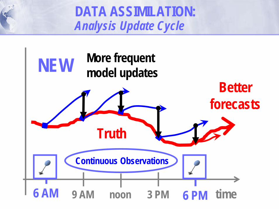
NEWBetter
forecasts
DATA ASSIMILATION:Analysis Update Cycle
6 AM time9 AM noon 3 PM 6 PM
Truth
6 AM 6 PM
Continuous Observations
More frequentmodel updates

RUC vector (m/s) forecast error – 1200 UTC 8 Feb 2001 – 250 hPa
12h init 12z 9h init 03z
6h init 06z 3h init 09z
Benj. et al. (2004, MWR)
Assimilation of high-freq. obsdecreases forecast error
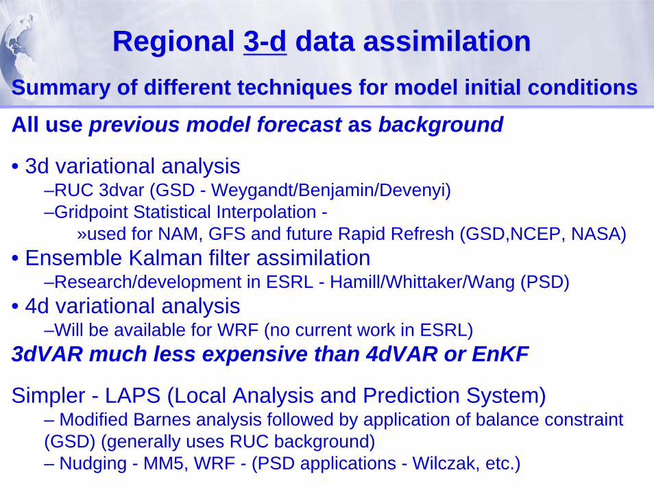
Regional 3-d data assimilationSummary of different techniques for model initial conditionsAll use previous model forecast as background
• 3d variational analysis–RUC 3dvar (GSD - Weygandt/Benjamin/Devenyi)–Gridpoint Statistical Interpolation -
»used for NAM, GFS and future Rapid Refresh (GSD,NCEP, NASA)• Ensemble Kalman filter assimilation
–Research/development in ESRL - Hamill/Whittaker/Wang (PSD)• 4d variational analysis
–Will be available for WRF (no current work in ESRL)3dVAR much less expensive than 4dVAR or EnKF
Simpler - LAPS (Local Analysis and Prediction System)– Modified Barnes analysis followed by application of balance constraint (GSD) (generally uses RUC background)– Nudging - MM5, WRF - (PSD applications - Wilczak, etc.)

NCEP Operational Model/Assimilation Systems
RUC – Rapid Update Cycle• Assimilation update every 1h• Developed largely at ESRL (GSD)• Forecasts out to 12h (72h in GSD experimental version)• Rapid Refresh - 2009
NAM (North American Mesoscale) –• 6h update frequency• Forecasts out to 84 h
GFS (Global Forecast System) –• 6h update frequency• Forecasts out to 240 h
Current RUC CONUS domain
Approx Rapid Refresh domain

RUC Hourly Assimilation Cycle
11 12 13 Time (UTC)
1-hrfcst
BackgroundFields
AnalysisFields
1-hrfcst
RUC3dvar
Obs
1-hrfcst
RUC3dvar
Obs
Cycpl
le hydrometeor, soil temp/moisture/snow us atmosphere state variables (θ,Δp,qv,u,v)
Hourly obs in 2008 RUCData Type ~NumberRawinsonde (12h) 80NOAA profilers 30 VAD winds 110-130 PBL – prof/RASS ~25Aircraft (V,temp) 1400-4500 TAMDAR (V,T,RH) 0-1000Surface/METAR 1500Surface/METAR 1500--1700 1700 Buoy/ship 100-150 GOES cloud winds 1000-2500 GOES cloud-top pres 10 km res GPS precip water ~300Mesonet (temp, dpt) ~7000Mesonet (wind) ~ 600METAR-cloud-vis-wx ~1500Radar / lightning 2km

RUC Hourly Assimilation Cycle
ECFeb11 12 13 14 15 16
Time (UTC)
1-hrfcst
BackgroundFields
AnalysisFields
1-hrfcst
3DVAR
Obs
1-hrfcst
1-hrfcst
1-hrfcst
3DVAR
Obs
3DVAR
Obs
3DVAR
Obs
1-hrfcst
3DVAR
Obs

RUC Hourly Assimilation Cycle
ECFeb11 12 13 14 15 16
Time (UTC)
9-hrfcst
BackgroundFields
AnalysisFields
9-hrfcst
9-hrfcst
3DVAR
Obs
9-hrfcst
12-hfcst
12-hfcst
3DVAR
Obs
3DVAR
Obs
3DVAR
Obs
3DVAR
Obs

Analysis increment (ΔA) -RUC 3dvar - 250hPa winds06z correction to 1h RUC forecast from 05z
250 hPa windsTODAY -0600z Thurs 4 Oct 2007RUC model initial conditions
Analysis = Background + ΔAAnalysis increment - produced from 3dVAR minimization problem
using observation errors, background error, spatial covariance of background error

Ensemble-based data assimilation• Parallel forecast and analysis cycles• Ensemble of forecasts is used to estimate forecast-error
statistics during the data assimilation

2-d surface regional data assimilationSummary of different techniques
– Variational analysis• Space-Time Mesoscale Anx Sys (STMAS)
(GSD) - 15-min frequency,uses subhour observations
• RUC (GSD) - integrated 2-d/3-d/PBL• Real-Time Mesoscale Analysis (RTMA)
with GSI (NCEP, GSD)– Optimal interpolation
• MSAS/RSAS (GSD)– Nudging - via MM5 (PSD)
All use METAR, mesonet surface data, buoySurface-only assimilation not for model init, useful for nowcasting
BackgroundRUC persistence

Why? Assess value added from current observingsystems
How?Run model cycle with all observationsRemove specific observations, repeat cycleCan test experimental observing systems
Observing System Experiments

Profiler Case Study ExampleMay 3, 1999 Oklahoma tornadoes
More energy for thunderstorms 6-h forecast with profiler data50+ tornadoes cause 42 deaths
in Oklahoma
Tornado paths

GPS-Precipitable Water example April 20, 2004 Utica, IL tornado
More energy for thunderstorms 3-h forecast with GPS-PW data
Tornadoes
GPS-PW
No GPS-PW

Radar obs – 00z 25 Mar 2007
With radar assimilation
Radar assimilation in RUC - winter storm example
RUC 3-h forecasts valid 00z 25 Mar 2007
No radar assimilation

25% / 50% / 75%
3km forecasts from Radar-Enhanced RUC Observed radar
6-h forecasts valid00z 16 Aug 2007
6-h fcst - HRRR but No-radar init - 3-km run
6-h fcst - HRRR 3-km run initialized with radar-enhanced
RUC
Radar-enhanced RUC essential for HRRR
forecast success

Additional future ESRL data assimilation
• Satellite radiance assimilation (already in GSI for Rapid Refresh)• Chemistry data assimilation (surface-based observations and satellite radiances) via GSI
• work underway by Grell, Pagowski, Devenyi (GSD) to determine spatial background error covariances• interaction with GMD - Carbon Tracker, intercomparisons• Global application of GSI with chemistry data assimilation (with NCEP, NASA, others)
• Ensemble Kalman Filter assimilation• Potential application at NCEP• Ensemble Rapid Refresh planned for 2012
• Radar/lightning assimilation (digital filter initialization-DFI-RUC/RR, 4dVAR, EnKF, variational, balance (LAPS Hot))