Embed Size (px)
Citation preview

U.S. Department of the InteriorU.S. Geological Survey
REGIONAL CURVE DEVELOPMENT AND
SELECTION OF A REFERENCE REACH IN THE
NON-URBAN, LOWLAND SECTIONS OF THE
PIEDMONT PHYSIOGRAPHIC PROVINCE,PENNSYLVANIA AND MARYLAND
by Kirk E. White
Water-Resources Investigations Report 01-4146
In cooperation with the
PENNSYLVANIA DEPARTMENT OF ENVIRONMENTAL PROTECTION
New Cumberland, Pennsylvania2001
ii
U.S. DEPARTMENT OF THE INTERIOR
GALE A. NORTON, Secretary
U.S. GEOLOGICAL SURVEY
Charles G. Groat, Director
For additional information Copies of this report may bewrite to: purchased from:
District Chief U.S. Geological SurveyU.S. Geological Survey, WRD Branch of Information Services215 Limekiln Road Box 25286New Cumberland, Pennsylvania 17070-2424 Denver, Colorado 80225-0286Email: [email protected] Telephone: 1-888-ASK-USGS
iii
CONTENTS
Page
Glossary . . . . . . . . . . . . . . . . . . . . . . . . . . . . . . . . . . . . . . . . . . . . . . . . . . . . . . . . . . . . . . . . . . . . . . . . . . . . . . vi
Abstract. . . . . . . . . . . . . . . . . . . . . . . . . . . . . . . . . . . . . . . . . . . . . . . . . . . . . . . . . . . . . . . . . . . . . . . . . . . . . . . .1
Introduction . . . . . . . . . . . . . . . . . . . . . . . . . . . . . . . . . . . . . . . . . . . . . . . . . . . . . . . . . . . . . . . . . . . . . . . . . . . .1
Purpose and scope. . . . . . . . . . . . . . . . . . . . . . . . . . . . . . . . . . . . . . . . . . . . . . . . . . . . . . . . . . . . . . . . .2
Description of study area . . . . . . . . . . . . . . . . . . . . . . . . . . . . . . . . . . . . . . . . . . . . . . . . . . . . . . . . . . .2
Study design . . . . . . . . . . . . . . . . . . . . . . . . . . . . . . . . . . . . . . . . . . . . . . . . . . . . . . . . . . . . . . . . . . . . . . . . . . .4
Regional-curve development . . . . . . . . . . . . . . . . . . . . . . . . . . . . . . . . . . . . . . . . . . . . . . . . . . . . . . . . . . . . .5
Description of streamflow-measurement stations . . . . . . . . . . . . . . . . . . . . . . . . . . . . . . . . . . . . . .6
Evaluation of the regional curves . . . . . . . . . . . . . . . . . . . . . . . . . . . . . . . . . . . . . . . . . . . . . . . . . . .12
Reference-reach selection. . . . . . . . . . . . . . . . . . . . . . . . . . . . . . . . . . . . . . . . . . . . . . . . . . . . . . . . . . . . . . . .14
Comparison of estimates from lowland regional curves and Dunne and Leopold regionalcurves for reference-reach characteristics. . . . . . . . . . . . . . . . . . . . . . . . . . . . . . . . . . . . . . . . . . . . . . .16
Limitations of the investigation . . . . . . . . . . . . . . . . . . . . . . . . . . . . . . . . . . . . . . . . . . . . . . . . . . . . . . . . . .18
Summary and conclusions . . . . . . . . . . . . . . . . . . . . . . . . . . . . . . . . . . . . . . . . . . . . . . . . . . . . . . . . . . . . . .19
Selected references . . . . . . . . . . . . . . . . . . . . . . . . . . . . . . . . . . . . . . . . . . . . . . . . . . . . . . . . . . . . . . . . . . . . .20
ILLUSTRATIONS
Figure 1. Map showing locations of the Lowland Sections of the PiedmontPhysiographic Province, project site, reference reach, and streamflow-measurement stations selected for regional-curve development,Pennsylvania and Maryland . . . . . . . . . . . . . . . . . . . . . . . . . . . . . . . . . . . . . . . . . 3
2-7. Photographs showing:
2. View looking upstream at stream reach containing the surveyed crosssection for Manatawny Creek near Pottstown, Pennsylvania. . . . . . . . . 6
3. View looking downstream at stream reach containing both surveyedcross sections for French Creek near Phoenixville, Pennsylvania. . . . . 7
4. View looking downstream at stream reach containing one of the twosurveyed cross sections for Perkiomen Creek at East Greenville,Pennsylvania. . . . . . . . . . . . . . . . . . . . . . . . . . . . . . . . . . . . . . . . . . . . . . . . . . 8
5. View looking upstream at stream reach containing both surveyed crosssections at West Branch Perkiomen Creek at Hillegas,Pennsylvania. . . . . . . . . . . . . . . . . . . . . . . . . . . . . . . . . . . . . . . . . . . . . . . . . 9
6. View looking downstream at stream reach containing both surveyedcross sections at Sucker Run near Coatesville, Pennsylvania. . . . . . . . 10
7. View looking upstream at stream reach containing the surveyed crosssection for Big Pipe Creek at Bruceville, Maryland. . . . . . . . . . . . . . . . 11

iv
ILLUSTRATIONS—Continued
Page
Figures 8-11. Graphs showing:
8. Regional curve representing relation between bankfull cross-sectionalarea and drainage area in non-urban, Lowland Sections of thePiedmont Physiographic Province, Pennsylvania and Maryland.. . . . 12
9. Regional curve representing relation between bankfull cross-sectionalmean depth and drainage area in non-urban, Lowland Sections ofthe Piedmont Physiographic Province, Pennsylvania andMaryland. . . . . . . . . . . . . . . . . . . . . . . . . . . . . . . . . . . . . . . . . . . . . . . . . . . . 13
10. Regional curve representing relation between bankfull cross-sectionalwidth and drainage area in non-urban, Lowland Sections of thePiedmont Physiographic Province, Pennsylvania and Maryland.. . . . 13
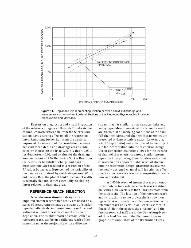
11. Regional curve representing relation between bankfull discharge anddrainage area in non-urban, Lowland Sections of the PiedmontPhysiographic Province, Pennsylvania and Maryland. . . . . . . . . . . . . 14
12. Map showing location of project site and reference reach on Bermudian Creek,Adams County, Pennsylvania . . . . . . . . . . . . . . . . . . . . . . . . . . . . . . . . . . . . . . . 15
13. Photograph showing view looking downstream at cross section 526 of thereference reach on Bermudian Creek, Adams County, Pennsylvania . . . . . . 15
TABLES
Table 1. Data collected during assessment of streamflow-measurement stations usedfor regional curves in the Lowland Sections of the PiedmontPhysiographic Province, Pennsylvania and Maryland . . . . . . . . . . . . . . . . . . . . . 5
2. Cross-section data collected from assessment of reference reach onBermudian Creek, Adams County, Pennsylvania. . . . . . . . . . . . . . . . . . . . . . . . . 17
3. Longitudinal-profile data collected from assessment of reference reach onBermudian Creek, Adams County, Pennsylvania. . . . . . . . . . . . . . . . . . . . . . . . . 18

v
CONVERSION FACTORS, VERTICAL DATUM, AND ABBREVIATIONS
Multiply By To obtain
Length
foot (ft) 0.3048 meter
mile (mi) 1.609 kilometer
Area
square foot (ft2) 0.09290 square meter
square mile (mi2) 2.590 square kilometer
Flow
cubic foot per second (ft3/s) 0.02832 cubic meter per second
Vertical datum: In this report, “sea level” refers to the National Geodetic Vertical Datum of 1929—ageodetic datum derived from a general adjustment of the first-order level nets of the United States andCanada, formerly called Sea Level Datum of 1929.

vi
GLOSSARY
The terms in this glossary were compiled from numerous sources. Some definitions have beenmodified for use within this report.
Bankfull channel—The active stream channel during the bankfull discharge.
Bankfull cross-sectional area—The cross-sectional area of the bankfull channel measuredperpendicular to the streamflow.
Bankfull discharge—The most effective streamflow for moving sediment, forming or removing bars,forming or changing bends and meanders, and generally doing work that results in theaverage morphological characteristics of channels (Dunne and Leopold, 1978).
Bankfull mean depth—The mean depth of the bankfull channel measured perpendicular to thestreamflow.
Bankfull stage—The elevation of the water surface during bankfull discharge.
Bankfull width—The width of the bankfull channel measured perpendicular to the streamflow.
Belt width—Lateral extent of two sequential meanders measured perpendicular to the valley slope.
D##—The numerical value (##) is the percentage of measured particles within a cross section havingan intermediate axis measuring less than a provided dimension.
Drainage area—That area, measured in a horizontal plane, enclosed by a topographic divide fromwhich direct surface runoff from precipitation normally drains by gravity into the streamabove the specified point.
Gage height—Water-surface elevation referred to some arbitrary station datum. Gage heightcommonly is used interchangeably with the more general term “stage.”
Reference reach—A reach of stream displaying characteristics of a stable stream channel that is usedas a template for design of a stream-restoration project.
Regional curve—A regression of the relations among drainage area, selected cross-sectionalparameters, and streamflow.
Regulation—A condition where streamflow is controlled by an upstream man-made feature.
Stream reach—A section of stream extending between 10 and 20 bankfull widths in length.
Stream restoration—For this report, adjusting stream dimensions, pattern, and profile to a conditionwhere it effectively accommodates a range of streamflow and sediment and supports diversehabitat.
Watershed—For this report, used interchangeably with drainage area.
1
ABSTRACT
Stream-restoration projects utilizing natural-stream designs frequently are based on the bank-full-channel characteristics of a stream reach that isaccommodating streamflow and sediment trans-port without excessive erosion or deposition. Thebankfull channel is identified by the use of fieldindicators and confirmed with tools such asregional curves. Channel dimensions were sur-veyed at six streamflow-measurement stationsoperated by the U.S. Geological Survey in theGettysburg-Newark Lowlands Section and Pied-mont Lowlands Section of the Piedmont Physio-graphic Province in Pennsylvania and Maryland.Regional curves were developed from regressionanalyses of the relation between drainage area andcross-sectional area, mean depth, width, andstreamflow of the bankfull channel. Regionalcurves were used to confirm the identification ofthe bankfull channel at a reference reach. Streamdimensions and characteristics of the referencereach were measured for extrapolation into thedesign of a steam-restoration project on BermudianCreek in Adams County, Pa.
Dimensions for cross-sectional area, meandepth, width, and computed streamflow of thebankfull channel in all surveyed riffle cross sec-tions in the reference reach were within the95-percent confidence interval bounding theregression line representing bankfull channelgeometry in the Lowland Sections of the PiedmontPhysiographic Province. The average bankfullcross-sectional area, bankfull mean depth, andcomputed bankfull discharge for riffle cross sec-tions in the reference reach ranged from 15.4 to16.5 percent less than estimates determined fromthe lowland regional curves. Average bankfullchannel width was about 2 percent greater thanestimates. Cross-sectional area, mean depth, andcomputed streamflow corresponding to the bank-full stage at the reference reach were 31.4, 44.4, and9.6 percent less, respectively, than estimatesderived from the regional curves developed by
Dunne and Leopold in 1978. Average bankfullchannel width at the reference reach was 16.7 per-cent greater than the Dunne and Leopold estimate.
The concepts of regional curves and refer-ence reaches can be valuable tools to supportefforts in stream restoration. Practitioners ofstream restoration need to recognize them as suchand realize their limitations. The small number ofstations available for analysis is a major limitingfactor in the strength of the results of this investi-gation. Subjective selection criteria may haveunnecessarily eliminated streamflow-measure-ment stations that could have been included in theregional curves. A bankfull discharge with a recur-rence interval within the 1- to 2-year range wasused as a criteria for confirmation of the bankfullstage at each streamflow-measurement station.Many researchers accept this range for recurrenceinterval of the bankfull discharge; however, litera-ture provides contradictory evidence. The use ofchannel-characteristics data from a reference reachwithout any monitoring data to document thestability of the reference reach over time is a topicof debate.
INTRODUCTION
Restoration projects of stream channels withexcessive erosion, deposition, or degraded habitatare being proposed by Federal, state, local, and pri-vate organizations in an effort to return theimpaired streams to more stable and biologicallyproductive conditions. Traditional engineeringpractices for stream stabilization frequently rely onhardening the sections of a stream impacted byerosive forces. Recent restoration projects proposeto utilize a natural stream design approach thatemphasizes working in concert with naturalstream processes as opposed to combating them.
Accelerated bank erosion in a section of Ber-mudian Creek, Adams County, Pa., is endangeringsome structures that border the creek and mayimpair present habitat. This reach of Bermudian
REGIONAL CURVE DEVELOPMENT AND SELECTION OF A REFERENCE REACH
IN THE NON-URBAN, LOWLAND SECTIONS
OF THE PIEDMONT PHYSIOGRAPHIC PROVINCE, PENNSYLVANIA AND MARYLAND
By Kirk E. White

2
Creek has been identified for streambank stabiliza-tion utilizing natural stream design. The restora-tion project will be designed by the PennsylvaniaDepartment of Environmental Protection (PaDEP),Bureau of Waterways Engineering, to accommo-date the bankfull discharge1 for this segment ofBermudian Creek.
The bankfull discharge is considered to bethe most effective streamflow for moving sedi-ment, forming or removing bars, forming orchanging bends and meanders, and generallydoing work that results in the average morphologi-cal characteristics of channels (Dunne andLeopold, 1978). Bankfull discharge occurs 1 or2 days each year with an average recurrence inter-val of 1.5 years (Leopold, 1994).
As the basis of the restoration design, thebankfull channel is defined and verified by fieldreconnaissance and direct measurement of channelfeatures. In addition to identifying the bankfullchannel on the basis of field indicators, an inde-pendent source of information that supports theidentification is needed.
Some of the more common tools availablefor supporting the selection of the bankfull channelare regional curves. One set of regional curvesdeveloped by Dunne and Leopold (1978) wasintended to be representative of bankfull-channeldimensions throughout the eastern United States.The applicability of one set of regional curves tothe multiple physiographic provinces and/or geol-ogy throughout Pennsylvania has not been veri-fied.
Dimensions of the bankfull channel aredefined by characteristics such as cross-sectionalarea, width, and mean depth. These characteristicsare highly correlated with drainage area (Dunneand Leopold, 1978). Regional curves are developedby regression analysis and provide estimatedbankfull-channel dimensions when drainage areais known. Estimates of bankfull dimensions arehelpful for confirming field identification of thebankfull channel.
PaDEP will develop a restoration design onthe basis of stream-channel measurements made ata stream reach having similar runoff characteris-tics to those of the proposed restoration site. Thestream reference reach must appear stable, for
example, capable of effectively accommodatingstreamflow and sediment without excessive chan-nel erosion or deposition. A comprehensive siteassessment of a reference reach will quantifynumerous bankfull-channel characteristics of anapparently stable form from which to simulate themorphology of restored channel.
In 1999, PaDEP proposed a study to developregional curves representative of channel geome-try in the Piedmont Physiographic Province and toquantify channel characteristics of a stream reachfor use as a template in a stream-restorationdesign. PaDEP and the U.S. Geological Survey(USGS) conducted this study as a cooperativeeffort.
Purpose and Scope
This report describes the methods used, datacollected, the results of regional-curve develop-ment, and the selection of a reference reach.Regional curves developed from channel-charac-teristics data collected from December 1999 toMarch 2000 that represent channel dimensions inthe Piedmont Lowland and Gettysburg-NewarkLowland Sections of the Piedmont PhysiographicProvince within Pennsylvania and Maryland arepresented. Channel characteristics of a referencereach on Bermudian Creek in the Gettysburg-New-ark Lowland Section in Adams County, Pa., alsoare presented.
Description of Stud y Area
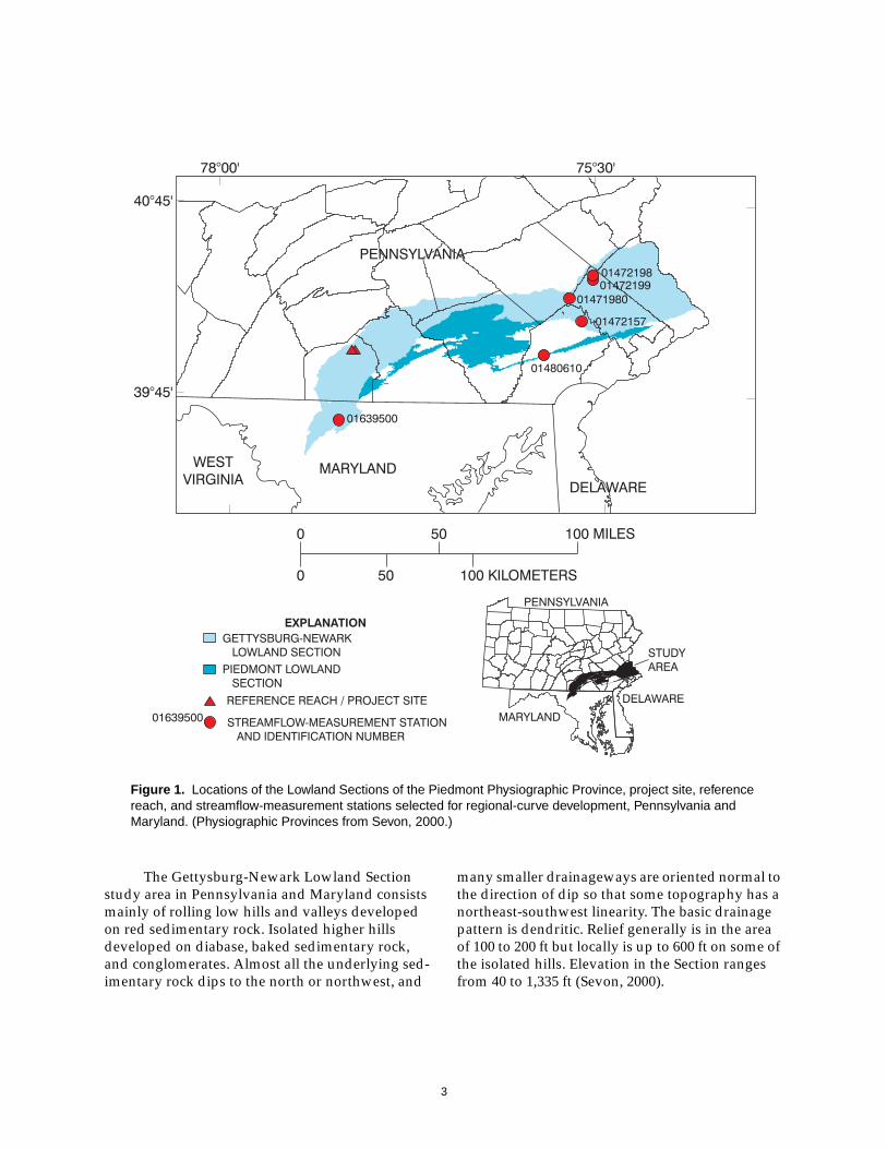
The Piedmont Physiographic Province isseparated into three sections: Piedmont UplandSection, Piedmont Lowland Section, and the Get-tysburg-Newark Lowland Section. This investiga-tion is restricted to streamflow-measurementstations in the two lowland sections. Major loca-tions and their physiographic contexts related tothis investigation are shown in figure 1.
The Piedmont Lowland Section study area inPennsylvania consists of broad, moderately dis-sected valleys separated by broad low hills. TheSection is developed primarily on limestone anddolomite rock. Karst topography is common. Localrelief in the Section generally is less than 100 ft butmay be as much as 300 ft. Land-surface elevationsin the Section range from 170 to 630 ft. Drainage isbasically dendritic in pattern, but some areas havevirtually no pattern because of the well-developedsubsurface drainage (Sevon, 2000).
1 Words presented in bold type are defined in theGlossary section of this report.
3
The Gettysburg-Newark Lowland Sectionstudy area in Pennsylvania and Maryland consistsmainly of rolling low hills and valleys developedon red sedimentary rock. Isolated higher hillsdeveloped on diabase, baked sedimentary rock,and conglomerates. Almost all the underlying sed-imentary rock dips to the north or northwest, and
many smaller drainageways are oriented normal tothe direction of dip so that some topography has anortheast-southwest linearity. The basic drainagepattern is dendritic. Relief generally is in the areaof 100 to 200 ft but locally is up to 600 ft on some ofthe isolated hills. Elevation in the Section rangesfrom 40 to 1,335 ft (Sevon, 2000).
Figure 1. Locations of the Lowland Sections of the Piedmont Physiographic Province, project site, referencereach, and streamflow-measurement stations selected for regional-curve development, Pennsylvania andMaryland. (Physiographic Provinces from Sevon, 2000.)

4
STUDY DESIGN
Only streamflow-measurement stations inthe Lowland Sections of the Piedmont Physio-graphic Province (Sevon, 2000) were included indeveloping these regional curves. Streamflow-measurement stations in the Upland Section of thePiedmont are omitted from this initial regionalrelation because of potentially major differences inrunoff characteristics between the Upland andLowland Sections. Subjective filtering criteria uti-lizing Geographic Information System land-use(U.S. Geological Survey, 1996) and stream cover-ages (Pennsylvania Department of Transportation,1997; Alexander and others, 1999) and additionalstation-information criteria were used to identifystreamflow-measurement stations with similarrunoff characteristics. The distribution of water-shed size, upstream from the selected stations,needed to be large enough to provide confidence inthe relation over a range of drainage areas. The fil-tering criteria used for selecting streamflow-mea-surement stations are listed below.
• The station is within the boundaries of aLowland Section of the PiedmontPhysiographic Province.
• The station has at least 10 years of record.
• The period of record for the station extendsat least to 1985 to minimize the extent towhich changes in land use may have affectedthe channel since the station was active.
• No more than 20 percent of the upstreamwatershed is classified as urban land use.
• Streamflow at the station is subjected to nogreater than 20 percent regulation.
The filtering criteria were applied to a com-prehensive listing of current and historical contin-uous- and partial-record stations operated by theUSGS in Pennsylvania and Maryland. Stationsmeeting all criteria were considered for inclusionin the investigation. Station descriptions describ-ing flow conditions and site characteristics are onfile in USGS offices, and in some instances, fieldreconnaissance was used to finalize the list of sta-tions included in the formulation of the regionalcurves. On the basis of the filtering criteria, sixstreamflow-measurement stations were selectedfor inclusion in the regional-curve development.
Procedures for field assessments, outlined byLeopold (1994) and Rosgen (1996), were followedfor the data collection at each station. Deviations
from the established procedure, warranted becauseof site conditions, are discussed along with the spe-cific details describing each streamflow-measure-ment station. Surveyed elevations are recorded tothe hundredth of a foot. Stream slopes calculatedfrom survey data are presented to the thousandthof a foot to provide the user with relative differ-ences between stream slopes and sufficient data forrounding purposes.
Field reconnaissance was conducted tolocate a reference reach that could serve as a tem-plate for the restoration design. Qualitative criteriawere developed to identify a stream reach thatappeared to effectively accommodate streamflowand sediment transport without excessive channelerosion or deposition. The criteria used to identifythe reference reach are as follows.
• Runoff characteristics are similar to those ofthe restoration project site.
• Channel width and depth within the reachdo not change dramatically.
• Rapidly eroding banks or areas of excessivedeposition are not evident.
• Riffles are characterized by an appropriatedegree of embeddedness.
• Accumulation of debris is not excessive.
The selection criteria were applied to streamsegments in Bermudian Creek and elsewhere inthe vicinity of the restoration project site. A 1,000-ftreach of Bermudian Creek upstream from theproject site met the criteria and was selected. Fieldprocedures for characterizing a reference reach,outlined by Harrelson and others (1994) and Ros-gen (1996), were followed for the assessment of thereference reach on Bermudian Creek.
5
REGIONAL-CURVE DEVELOPMENT
Because many restoration designs are depen-dent on bankfull-channel dimensions, correctlyidentifying the bankfull stage is essential to a suc-cessful design. According to Dunne and Leopold(1978), the width, mean depth, and cross-sectionalarea of the bankfull channel are highly correlatedwith the size of the basin (drainage area) in a givenregion. Familiarity with these regional relations isuseful for field identification of the bankfull chan-nel. A regional curve is a regression of these rela-tions and provides estimated channel dimensionsand streamflow for the bankfull channel whendrainage area is known.
USGS streamflow-measurement stationsprovide a source of readily available and reliableinformation from which regional curves can bedeveloped. The drainage area has been accuratelydetermined for each station. Streamflow measure-ments provide a long-term record of channeldimensions over a broad range of streamflows.Peak-flow analysis of station record provides thefrequencies of occurrence for a range of stream-flows. By identifying the bankfull stage at astreamflow-measurement station, the investigatorcan determine if the associated streamflow iswithin the 1- to 2-year recurrence-interval range.
Once confirmed, the bankfull channel is surveyedat riffle cross sections and the cross-sectionaldimensions are determined. Plotting the bankfull-channel dimensions and streamflow for eachstreamflow-measurement station in relation to itsdrainage area provides the data necessary fordefining the relation. A “best-fit” regression line isapplied to the data to form the regional curve. Useof the USGS streamflow-measurement data doesnot necessarily provide absolute confirmation ofthe bankfull discharge but does support the identi-fication of the bankfull channel when used alongwith other field indicators. Once developed, inves-tigators can use regional curves at unmonitoredsites to support or refute their identification of thebankfull channel within regions having similarrunoff characteristics.
Applying the previously described filteringcriteria to USGS streamflow-measurement stationsidentified six stations in the Lowland Sections ofthe Piedmont Physiographic Province. Characteris-tics of each streamflow-measurement stationincluded in the investigation are discussed below.Other data directly relating to the site assessmentsare included in table 1. Rosgen (1996) stream typerefers to a stream classification based on the mor-phological characteristics of a stream reach.
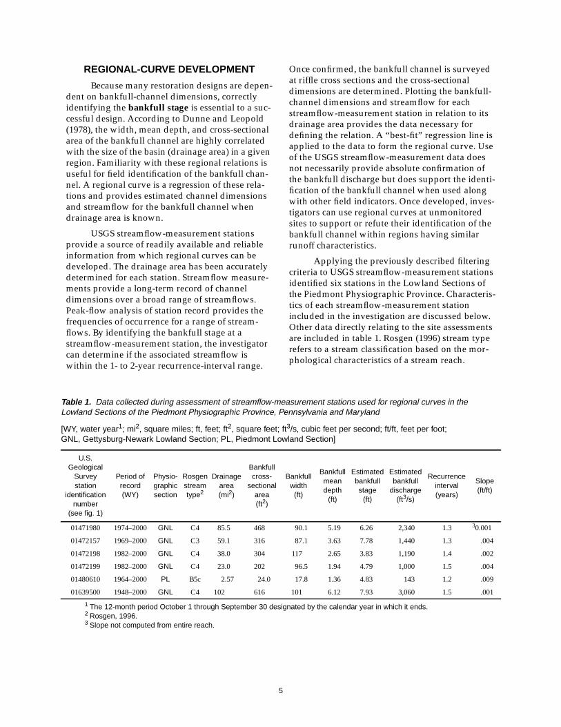
Table 1. Data collected during assessment of streamflow-measurement stations used for regional curves in theLowland Sections of the Piedmont Physiographic Province, Pennsylvania and Maryland
[WY, water year1; mi2, square miles; ft, feet; ft2, square feet; ft3/s, cubic feet per second; ft/ft, feet per foot;GNL, Gettysburg-Newark Lowland Section; PL, Piedmont Lowland Section]
U.S.Geological
Surveystation
identificationnumber
(see fig. 1)
Period ofrecord(WY)
Physio-graphicsection
Rosgenstreamtype2
Drainagearea(mi2)
Bankfullcross-
sectionalarea(ft2)
Bankfullwidth
(ft)
Bankfullmeandepth
(ft)
Estimatedbankfullstage
(ft)
Estimatedbankfull
discharge(ft3/s)
Recurrenceinterval(years)
Slope(ft/ft)
01471980 1974–2000 GNL C4 85.5 468 90.1 5.19 6.26 2,340 1.3 30.001
01472157 1969–2000 GNL C3 59.1 316 87.1 3.63 7.78 1,440 1.3 .004
01472198 1982–2000 GNL C4 38.0 304 117 2.65 3.83 1,190 1.4 .002
01472199 1982–2000 GNL C4 23.0 202 96.5 1.94 4.79 1,000 1.5 .004
01480610 1964–2000 PL B5c 2.57 24.0 17.8 1.36 4.83 143 1.2 .009
01639500 1948–2000 GNL C4 102 616 101 6.12 7.93 3,060 1.5 .001
1 The 12-month period October 1 through September 30 designated by the calendar year in which it ends.2 Rosgen, 1996.3 Slope not computed from entire reach.

6
Description of Streamflo w-MeasurementStations
USGS Station Number: 01471980Stream Name: Manatawny CreekLocation: near Pottstown, Pennsylvania(Lat 40°16′22″, Long 75°40′49″)
The streamflow-measurement station onManatawny Creek monitors streamflow from an85.5-mi2 watershed, less than 2 percent of which isclassified as urban land use (U.S. Geological Sur-vey, 1996). Streamflow upstream from the station isnot regulated, 26 percent of the watershed isunderlain by carbonate geology, and 56 percent iscovered by forest. Only about 15 percent of theManatawny Creek watershed upstream from thestation is in the Gettysburg-Newark Lowland Sec-tion of the Piedmont Physiographic Province(Pennsylvania Department of Transportation, 1997;Sevon, 2000). The remainder is in the Great ValleySection of the Ridge and Valley PhysiographicProvince (45 percent) and the Reading Prong Sec-tion of the New England Physiographic Province(40 percent). Manatawny Creek near Pottstown is acontinuous streamflow-measurement station about180 ft upstream from a bridge. The bridge does notappear to constrict the bankfull discharge. Stream-flow-measurement data stored in the USGS hydro-logic data base indicate wading measurements at
this station are usually made in the approximatelocation of the cross-section survey. High-watermeasurements are made from the bridge.
The bankfull channel clearly was definedthroughout most of the reach by field indicatorssuch as riparian vegetation and depositional fea-tures. The cross-section survey was limited to onecross section conducted in a “run” (an area of inter-mediate relative velocity) because of the presenceof a divided channel throughout the upstream halfof the reach. Two riffles were eliminated from con-sideration because of their proximity to thedivided channel. One riffle was within the dividedchannel section, and channel geometry wasstrongly affected. The other riffle was at the conflu-ence of the two flow paths and was still in transi-tion to a single flow path. The stream reachcontaining the surveyed cross section is shown infigure 2. A pebble count was conducted within thecross section to determine the distribution of parti-cle sizes on the streambed. The elevation of thebankfull stage was surveyed to the outside verticalstaff gage from which the gage height and associ-ated bankfull discharge were determined. Thechannel geometry at the estimated bankfull dis-charge, as indicated by streamflow-measurementdata in the USGS database, was used to assist withconfirmation of bankfull selection.
Figure 2. View looking upstream at stream reach containing the surveyedcross section for Manatawny Creek near Pottstown, Pennsylvania.

7
USGS Station Number: 01472157Stream Name: French CreekLocation: near Phoenixville, Pennsylvania(Lat 40°09′05″, Long 75°36′06″)
The streamflow-measurement station onFrench Creek monitors streamflow from a 59.1-mi2
watershed, less than 1 percent of which is classifiedas urban land use (U.S. Geological Survey, 1996).About 2 percent of the watershed upstream fromthe station is regulated, carbonate geology is notpresent within the watershed, and 64 percent ofthe watershed is covered by forest. About 38 per-cent of the French Creek watershed upstream fromthe station is in the Gettysburg-Newark LowlandSection of the Piedmont Physiographic Province(Pennsylvania Department of Transportation, 1997;Sevon, 2000). The remainder is in the PiedmontUplands. French Creek near Phoenixville is a con-tinuous streamflow-measurement station about70 ft downstream from a bridge. The bridge mayhave a slight effect on the bankfull discharge.Streamflow-measurement data stored in the USGShydrologic data base indicate wading measure-ments usually are made in the vicinity of the sta-tion. High-water measurements are made from thebridge.
The bankfull channel, in the vicinity of thestreamflow-measurement station, was poorlydefined because of excessive bank erosion. Directlyacross from the streamflow-measurement shelter isan auxiliary channel, separated from the mainchannel by a berm that extends 500 ft downstream.This auxiliary channel is a component of the bank-full channel and contains flowing water duringmoderate streamflow. Riffles within this area werenot surveyed because of the resulting dividedchannel at the bankfull discharge. Excellent bank-full indicators were identified on a point bar begin-ning about 700 ft downstream from the station.Two cross sections were surveyed at riffles withinthe reach, and pebble counts were conductedwithin each to determine the particle distribution.The stream reach containing both surveyed crosssections is shown in figure 3. The bankfull widths,mean depths, and cross-sectional areas of the twocross sections were averaged to determine theinput for the regional curves. The bankfull eleva-tion was extended upstream to the streamflow-measurement station, with some difficulty, todetermine the gage height and streamflow associ-ated with the bankfull stage. The channel geome-try at the estimated bankfull discharge, asindicated by streamflow-measurement data in theUSGS data base, was used to assist with confirma-tion of the bankfull selection.
Figure 3. View looking downstream at stream reach containing both surveyedcross sections for French Creek near Phoenixville, Pennsylvania.

8
USGS Station Number: 01472198Stream Name: Perkiomen CreekLocation: at East Greenville, Pennsylvania(Lat 40°23′38″, Long 75°30′57″)
The streamflow-measurement station onPerkiomen Creek monitors streamflow from a38.0-mi2 watershed, 2 percent of which has urbanland use (U.S. Geological Survey, 1996). Stream-flow upstream from the station is not regulated,3 percent of the watershed is underlain by carbon-ate geology, and 54 percent is covered by forest.About 51 percent of the Perkiomen Creek water-shed, upstream from the station, is in the Gettys-burg-Newark Lowland Section of the PiedmontPhysiographic Province (Pennsylvania Depart-ment of Transportation, 1997; Sevon, 2000). Theremainder is in the Reading Prong Section of theNew England Physiographic Province (40 percent)and the Great Valley Section of the Ridge and Val-ley Physiographic Province (9 percent). PerkiomenCreek at East Greenville is a continuous stream-flow-measurement station adjacent to a pool cre-ated by a weir immediately downstream from theshelter. A multi-span bridge is 100 ft downstream
from the weir and does not appear to constrict thebankfull discharge. Wading streamflow measure-ments usually are made downstream from the weirand the bridge. High-water measurements aremade from the bridge.
The bankfull channel in the assessed reachwas fairly well defined. Two cross sections weresurveyed at riffles within the reach, and pebblecounts were conducted within each to determinethe particle distribution. A section of the streamreach previously was stabilized; however, crosssections were beyond the affected stream section.The stream reach containing the upstream sur-veyed cross section is shown in figure 4. The bank-full widths, mean depths, and cross-sectional areasof the two cross sections were averaged to deter-mine the input for the regional curves. The bank-full water-surface elevation could not be extendedupstream to the streamflow-measurement stationbecause of the relatively high-profile weir. Thechannel geometry at the estimated bankfull dis-charge, as indicated by streamflow-measurementdata stored in the USGS data base, was used toassist with confirmation of the bankfull selection.
Figure 4. View looking downstream at stream reach containing one of the twosurveyed cross sections for Perkiomen Creek at East Greenville, Pennsylvania.

9
USGS Station Number: 01472199Stream Name: West Branch Perkiomen CreekLocation: at Hillegas, Pennsylvania(Lat 40°22′26″, Long 75°31′22″)
The streamflow-measurement station on theWest Branch of Perkiomen Creek monitors stream-flow from a 23.0-mi2 watershed, 2 percent of whichis classified as urban land use (U.S. Geological Sur-vey, 1996). Streamflow is not regulated above thestation, 4 percent of the watershed is underlain bycarbonate geology, and 61 percent is covered byforest. About 43 percent of the watershed upstreamfrom the station is in the Gettysburg-Newark Low-land Section of the Piedmont Physiographic Prov-ince (Pennsylvania Department of Transportation,1997; Sevon, 2000). The remainder of the water-shed is in the Reading Prong Section of the NewEngland Physiographic Province (50 percent) andthe Great Valley Section of the Ridge and ValleyPhysiographic Province (7 percent). West BranchPerkiomen Creek at Hillegas is a continuousstreamflow-measurement station adjacent to a poolcreated by a weir immediately downstream fromthe shelter. The rating is considered to be poorlydefined above 560 ft3/s because of the lack of agood location from which to make high-water
measurements. Wading streamflow measurementsare conducted throughout the stream reach bothupstream and downstream from the weir.
The assessed reach was separated from thepool behind the weir by a high-profile rock out-crop. The bankfull channel clearly was definedthroughout most of the assessed reach. Two crosssections were surveyed at riffles within theassessed reach, and pebble counts were conductedwithin each to determine the particle distribution.The stream reach containing both surveyed crosssections is shown in figure 5. The bankfull widths,mean depths, and cross-sectional areas of the twocross sections were averaged to determine theinput for the regional curves. Despite the presenceof the rock outcrop, the bankfull elevation could beextended to the outside vertical staff gage adjacentto the streamflow-measurement station, with rea-sonable certainty, to determine the gage height andstreamflow associated with the bankfull stage. Thechannel geometry at the estimated bankfull dis-charge, as indicated by measurement data in theUSGS database, was used to assist with confirma-tion of the bankfull selection.
Figure 5. View looking upstream at stream reach containing both surveyedcross sections at West Branch Perkiomen Creek at Hillegas, Pennsylvania.

10
USGS Station Number: 01480610Stream Name: Sucker RunLocation: near Coatesville, Pennsylvania(Lat 39°58′20″, Long 75°51′03″)
The streamflow-measurement station onSucker Run monitors streamflow from a 2.57-mi2
watershed, 11.6 percent of which is classified asurban land use (U.S. Geological Survey, 1996).Streamflow is not regulated above the station,35.7 percent of the watershed is underlain by car-bonate geology, and about 45 percent is covered byforest. Just over half of the Sucker Run watershed(53 percent) upstream from the station is in thePiedmont Lowland Section of the Piedmont Physi-ographic Province. (Pennsylvania Department ofTransportation, 1997; Sevon, 2000). The remainderof the watershed is in the Piedmont Upland Sec-tion. Two bridges, which are 227 ft apart, boundthe reach and may slightly constrict the bankfulldischarge. Sucker Run near Coatesville is a crest-stage, partial-record station that does not collectcontinuous data but is operated primarily to docu-ment peak streamflow. Wading streamflow mea-
surements usually are made throughout thesection of stream in which the cross-section sur-veys were conducted. High-water measurementsare made from the bridge immediately upstreamfrom the station.
Definition of the bankfull channel, in thevicinity of the streamflow-measurement station,was fair. Two cross sections were surveyed at rif-fles within the reach, and pebble counts were con-ducted within each to determine the particledistribution. The stream reach containing both sur-veyed cross sections is shown in figure 6. Thebankfull widths, mean depths, and cross-sectionalareas of the two cross sections were averaged todetermine the input for the regional curves. Thebankfull water-surface elevation was extrapolatedto the outside vertical staff gage, with reasonablecertainty, to determine the gage height and stream-flow associated with the bankfull stage. The chan-nel geometry at the estimated bankfull discharge,as indicated by streamflow-measurement data inthe USGS data base, was used to assist with confir-mation of the bankfull selection.
Figure 6. View looking downstream at stream reach containing both surveyedcross sections at Sucker Run near Coatesville, Pennsylvania.
11
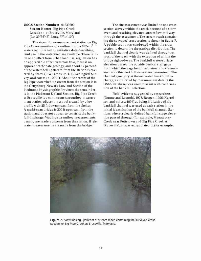
USGS Station Number: 01639500Stream Name: Big Pipe CreekLocation: at Bruceville, Maryland(Lat 39°36′45″, Long 77°14′10″)
The streamflow-measurement station on BigPipe Creek monitors streamflow from a 102-mi2
watershed. Limited quantitative data describingland use in the watershed are available. There is lit-tle or no effect from urban land use, regulation hasno appreciable effect on streamflow, there is noapparent carbonate geology, and about 17 percentof the watershed upstream from the station is cov-ered by forest (R.W. James, Jr., U.S. Geological Sur-vey, oral commun., 2001). About 32 percent of theBig Pipe watershed upstream from the station is inthe Gettysburg-Newark Lowland Section of thePiedmont Physiographic Province; the remainderis in the Piedmont Upland Section. Big Pipe Creekat Bruceville is a continuous streamflow-measure-ment station adjacent to a pool created by a low-profile weir 25 ft downstream from the shelter.A multi-span bridge is 300 ft upstream from thestation and does not appear to constrict the bank-full discharge. Wading streamflow measurementsusually are made upstream from the station. High-water measurements are made from the bridge.
The site assessment was limited to one cross-section survey within the reach because of a stormevent and resulting elevated streamflow midwaythrough the assessment. The stream reach contain-ing the surveyed cross section is shown in figure 7.A pebble count was conducted within the crosssection to determine the particle distribution. Thebankfull channel clearly was defined throughoutmost of the reach with the exception of within thebridge right-of-way. The bankfull water-surfaceelevation passed the outside vertical staff gagefrom which the gage height and streamflow associ-ated with the bankfull stage were determined. Thechannel geometry at the estimated bankfull dis-charge, as indicated by measurement data in theUSGS database, was used to assist with confirma-tion of the bankfull selection.
Field evidence suggested by researchers(Dunne and Leopold, 1978, Rosgen, 1996, Harrel-son and others, 1994) as being indicative of thebankfull channel was used at each station in theinitial identification of the bankfull channel. Sta-tions where a clearly defined bankfull stage eleva-tion passed through (for example, ManatawnyCreek near Pottstown and Big Pipe Creek atBruceville), or was extrapolated to (for example,
Figure 7. View looking upstream at stream reach containing the surveyed crosssection for Big Pipe Creek at Bruceville, Maryland.

12
Sucker Run near Coatesville and West BranchPerkiomen Creek at Hillegas), the outside verticalstaff gage with reasonable certainty provided themost confidence for the bankfull determination.Stations where the bankfull stage was not clearlydefined in the vicinity of the streamflow-measure-ment station (for example, French Creek nearPhoenixville) required more emphasis on addi-tional data for confirmation. Perkiomen Creek atEast Greenville, with fair definition of the bankfullchannel but no opportunity for comparison ofbankfull stage to the outside vertical staff gage,required the most reliance on additional data forconfirmation of bankfull identification. Channelgeometry as indicated from streamflow measure-ments made at the station, streamflow computedfrom cross-section characteristics, and determina-tion of the sediment size being transported duringthe bankfull discharge were used to assist withconfirmation of bankfull channel dimensions at allstations.
Evaluation of the Regional Cur ves
The regional curves presented in figures 8through 11 show the relation between drainagearea and bankfull cross-sectional area, bankfullmean depth, bankfull width, and bankfull dis-
charge, respectively. The 95-percent confidenceinterval indicates a band within which there is a95-percent probability that estimates of channelgeometry and streamflow for that particular drain-age area will occur. The coefficient of determina-tion, R2, is a measure of the variability in thechannel-geometry estimate accounted for by thedrainage area. Bankfull cross-sectional area (fig. 8)and bankfull discharge (fig. 11) have the strongestrelation to drainage area as evidenced by R2 valuesof 0.98. Both relations have a p-value less than0.001, a residual standard error of 0.07 or less, anda t-value for the drainage-area coefficient between15.8 and 16.4. Users of these two regional curveswould expect to obtain the most reliable estimates.The relation between bankfull mean depth anddrainage area (fig. 9) with an R2 of 0.84 and ap-value less than 0.01 (residual standard error= 0.11 and a t-value = 4.6) indicates a very stronglinear trend between all the stations except the onewith the smallest drainage area. The relationbetween bankfull width and drainage area (fig. 10)is the weakest of the four—R2 value of 0.79,p-value less than 0.02, a residual standard error of0.16, and a t-value for the drainage area coefficientof 3.9.
Figure 8. Regional curve representing relation between bankfull cross-sectional areaand drainage area in non-urban, Lowland Sections of the Piedmont PhysiographicProvince, Pennsylvania and Maryland.

13
Figure 9. Regional curve representing relation between bankfull cross-sectional meandepth and drainage area in non-urban, Lowland Sections of the Piedmont PhysiographicProvince, Pennsylvania and Maryland.
Figure 10. Regional curve representing relation between bankfull cross-sectional widthand drainage area in non-urban, Lowland Sections of the Piedmont PhysiographicProvince, Pennsylvania and Maryland.
14
Regression diagnostics and visual inspectionof the relations in figures 8 through 11 indicate thechannel-characteristics data from the Sucker Runstation have a strong effect on all the regressionlines. Removing Sucker Run from the analysisimproved the strength of the correlation betweenbankfull mean depth and drainage area as indi-cated by increasing the R2 to 0.99 (p-value < 0.001,residual error = 0.02, and t-value for the drainagearea coefficient = 17.9). Removing Sucker Run fromthe curves for bankfull discharge and bankfullcross-sectional area resulted in a reduction of theR2 values but at least 90 percent of the variability ofthe data was explained by the drainage area. With-out Sucker Run, the plot of bankfull channel widthis basically flat and shows essentially no sloping-linear relation to drainage area.
REFERENCE-REACH SELECTION
New stream-restoration designs forimpaired stream reaches frequently are based on aseries of measurements made at streams of similartype that effectively accommodate streamflow andsediment without excessive channel erosion ordeposition. The “stable” reach of stream, called areference reach, can be on a different reach of thesame stream as the project site or on a different
stream that has similar runoff characteristics andvalley type. Measurements at the reference reachare directed at quantifying conditions of the bank-full channel. Measured channel characteristics arepresented as dimensionless ratios (for example,width/depth ratio) and extrapolated to the projectsite for incorporation into the restoration design.Use of dimensionless ratios allows for the transferof channel characteristics among similar streamtypes. By incorporating dimensionless ratios thatcharacterize an apparent stable reach of streaminto the restoration design, practitioners assumethe newly designed channel will function as effec-tively as the reference reach at transporting stream-flow and sediment.
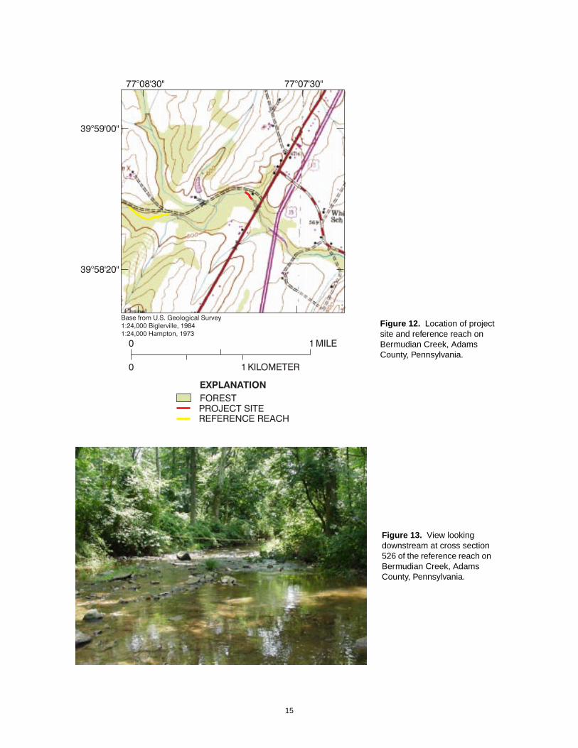
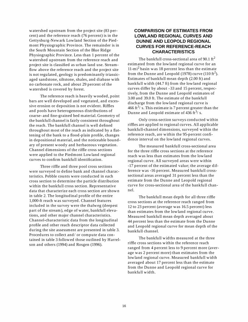
A 1,000-ft reach of stream that met all estab-lished criteria for a reference reach was identifiedon Bermudian Creek, less than 1 mi upstream fromthe project site. The location of the reference reachand its proximity to the project site is shown onfigure 12. A representative riffle cross section in thereference reach on Bermudian Creek is shown infigure 13. Both the project site (14.8 mi2) and theference reach (11 mi2) are in the Gettysburg-New-ark Lowland Section of the Piedmont Physio-graphic Province. Most of the Bermudian Creek
Figure 11. Regional curve representing relation between bankfull discharge anddrainage area in non-urban, Lowland Sections of the Piedmont Physiographic Province,Pennsylvania and Maryland.
15
Figure 12. Location of projectsite and reference reach onBermudian Creek, AdamsCounty, Pennsylvania.
Figure 13. View lookingdownstream at cross section526 of the reference reach onBermudian Creek, AdamsCounty, Pennsylvania.
16
watershed upstream from the project site (83 per-cent) and the reference reach (76 percent) is in theGettysburg-Newark Lowland Section of the Pied-mont Physiographic Province. The remainder is inthe South Mountain Section of the Blue RidgePhysiographic Province. Less than 1 percent of thewatershed upstream from the reference reach andproject site is classified as urban land use. Stream-flow above the reference reach and the project siteis not regulated, geology is predominantly triassic-aged sandstone, siltstone, shales, and diabase withno carbonate rock, and about 29 percent of thewatershed is covered by forest.
The reference reach is heavily wooded, pointbars are well developed and vegetated, and exces-sive erosion or deposition is not evident. Rifflesand pools have heterogeneous distributions ofcoarse- and fine-grained bed material. Geometry ofthe bankfull channel is fairly consistent throughoutthe reach. The bankfull channel is well definedthroughout most of the reach as indicated by a flat-tening of the bank to a flood-plain profile, changesin depositional material, and the noticeable bound-ary of present woody and herbaceous vegetation.Channel dimensions of the riffle cross sectionswere applied to the Piedmont Lowland regionalcurves to confirm bankfull identification.
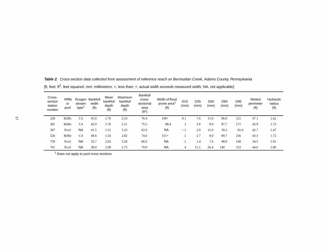
Three riffle and three pool cross sectionswere surveyed to define bank and channel charac-teristics. Pebble counts were conducted in eachcross section to determine the particle distributionwithin the bankfull cross section. Representativedata that characterize each cross section are shownin table 2. The longitudinal profile of the entire1,000-ft reach was surveyed. Channel featuresincluded in the survey were the thalweg (deepestpart of the stream), edge of water, bankfull eleva-tions, and other major channel characteristics.Channel-characteristic data from the longitudinalprofile and other reach descriptor data collectedduring the site assessment are presented in table 3.Procedures to collect and/or compute data con-tained in table 3 followed those outlined by Harrel-son and others (1994) and Rosgen (1996).
COMPARISON OF ESTIMATES FROMLOWLAND REGIONAL CURVES ANDDUNNE AND LEOPOLD REGIONALCURVES FOR REFERENCE-REACH
CHARACTERISTICS
The bankfull cross-sectional area of 90.1 ft2
estimated from the lowland regional curve for an11-mi2 basin was 18 percent less than the estimatefrom the Dunne and Leopold (1978) curve (110 ft2).Estimates of bankfull mean depth (2.00 ft) andbankfull width (44.7 ft) from the lowland regionalcurves differ by about –33 and 15 percent, respec-tively, from the Dunne and Leopold estimates of3.00 and 39.0 ft. The estimate of the bankfulldischarge from the lowland regional curve is466 ft3/s. This estimate is 7 percent greater than theDunne and Leopold estimate of 436 ft3/s.
Only cross-section surveys conducted withinriffles are applied to regional curves. All applicablebankfull-channel dimensions, surveyed within thereference reach, are within the 95-percent confi-dence interval on the lowland regional curves.
The measured bankfull cross-sectional areafor the three riffle cross sections at the referencereach was less than estimates from the lowlandregional curve. All surveyed areas were within-17 percent of the estimated value; the average dif-ference was -16 percent. Measured bankfull cross-sectional areas averaged 31 percent less than theestimate from the Dunne and Leopold regionalcurve for cross-sectional area of the bankfull chan-nel.
The bankfull mean depth for all three rifflecross sections at the reference reach ranged from12 to 23 percent (average was 16.5 percent) lessthan estimates from the lowland regional curve.Measured bankfull mean depth averaged about44 percent less than the estimate from the Dunneand Leopold regional curve for mean depth of thebankfull channel.
The bankfull widths measured at the threeriffle cross sections within the reference reachranged from 4 percent less to 9 percent more (aver-age was 2 percent more) than estimates from thelowland regional curve. Measured bankfull widthaveraged about 17 percent less than the estimatefrom the Dunne and Leopold regional curve forbankfull width.
17
Table 2. Cross-section data collected from assessment of reference reach on Bermudian Creek, Adams County, Pennsylvania
[ft, feet; ft2, feet squared; mm, millimeters; <, less than; +, actual width exceeds measured width; NA, not applicable]
Cross-sectionstationnumber
Riffleor
pool
Rosgenstreamtype1
Bankfullwidth
(ft)
Meanbankfulldepth
(ft)
Maximumbankfulldepth
(ft)
Bankfullcross-
sectionalarea(ft2)
Width of floodprone area1
(ft)
D15(mm)
D35(mm)
D50(mm)
D84(mm)
D95(mm)
Wettedperimeter
(ft)
Hydraulicradius
(ft)
228 Riffle C4 45.0 1.70 2.33 76.4 190+ 0.1 7.6 15.0 96.0 211 47.1 1.62
281 Riffle C4 42.9 1.76 2.11 75.5 88.4 .1 3.6 8.9 87.7 171 43.9 1.72
367 Pool NA 41.5 1.51 3.23 62.6 NA <.1 2.0 12.0 39.2 81.6 42.7 1.47
526 Riffle C4 48.6 1.54 2.82 74.6 151+ .1 2.7 8.0 89.7 256 43.3 1.72
758 Pool NA 32.7 2.02 3.26 66.0 NA .1 1.4 7.6 48.0 168 34.5 1.91
791 Pool NA 38.0 2.08 3.75 79.0 NA .4 11.1 26.4 140 233 44.0 1.80
1 Does not apply to pool cross sections.

18
Streamflows associated with each cross sec-tion at the reference reach were computed fromchannel dimensions, representative channel rough-ness, and surface-water slope as surveyedthroughout the reach. The computed bankfull dis-charges for each cross section ranged from 389 to401 ft3/s; the average was 394 ft3/s. The lowlandregional curve estimated 466 ft3/s for the bankfulldischarge in an 11.0-mi2 watershed, about 18 per-cent greater than the average at the reference reach.The streamflow estimated from the Dunne andLeopold regional curve for the bankfull discharge(436 ft3/s) was 10.6 percent greater than the aver-age computed streamflow for riffle cross sections atthe reference reach.
LIMITATIONS OF THE INVESTIGATION
The small number of stations available foranalysis is a major limiting factor in the strength ofthe results of this investigation. Including addi-tional data in each regression would provide a bet-ter estimate of the relations among bankfullchannel geometry, streamflow, and drainage area.Additional data points would most likely reducethe appreciable effect of Sucker Run. Subjective fil-tering criteria may have eliminated unnecessarilythe streamflow-measurement stations that couldhave been included in the regional curves. Con-versely, the land-use percentages characterizingthe watershed may effect runoff characteristics at amuch lower percentage than the criteria wouldindicate. For example, numerous studies suggestchannel stability may be affected by urban land
use and regulation at percentages lower than the20 percent used in this report. As additionalstreamflow-measurement stations in the PiedmontUpland Section are assessed, the estimates pro-vided by the relations of channel characteristicsand drainage in the Lowland Sections of the Pied-mont Physiographic Province may be improved byincluding these data. Statistical tests could be usedto determine if the differences in runoff character-istics warrant separate regional curves for theUpland Section and the two Lowland Sections ofthe Piedmont Physiographic Province or if one all-inclusive regional curve is appropriate.
The regional curves presented here shouldonly be used for the confirmation of the bankfullchannel at streams in the Lowland Sections of thePiedmont Physiographic Province. The assump-tion made for this investigation is that the bankfulldischarge is within the 1- to 2-year recurrence-interval range. Thorne and others (1997) state “thewidely reported assertion that bankfull dischargeoccurs on average once every 1 to 2 years is nowseen as an oversimplification.” If runoff patterns ata streamflow-measurement station are such thatthe bankfull discharge may occur more often thanthis 1- to 2-year frequency, the recurrence-intervalcriteria did not substantiate identification of thebankfull channel as it was intended. In addition,land use and other basin characteristics upstreamfrom the reach in consideration should be similarto those used for the selection criteria in thisassessment.
Table 3. Longitudinal-profile data collected from assessment ofreference reach on Bermudian Creek, Adams County, Pennsylvania
[ft, feet; ft/ft, feet per foot; <, less than]
Reach length(ft)
Bankfull slope(ft/ft)
SinuosityValley slope
(ft/ft)
1,000 0.008 1.12 0.008
Average riffleslope(ft/ft)
Averagepool slope
(ft/ft)
Average pool-to-poolspacing
(ft)
Averagemeander
length(ft)
Average radiusof curvature
(ft)
Average beltwidth
(ft)
0.016 0.001 93.0 149 126 77.0
Riffle sloperange(ft/ft)
Pool sloperange(ft/ft)
Pool-to-poolspacing range
(ft)
Meanderlength range
(ft)
Radius ofcurvature
range(ft)
Belt widthrange
(ft)
0.008 - 0.026 <0.001 - 0.003 39.0 - 150 105 - 248 60.0 - 340 44.0 - 100
19
With regard to the reference reach, the quali-tative designation of stability for the stream reach,without monitoring over time, may be inaccurate.The incorrect designation of the reference reach asa stable channel may introduce errors into theproject design that is so closely related to the refer-ence reach and its assumed stability. Use of thesereference-reach data should be limited to projectsites in areas having similar runoff characteristicsand valley type.
SUMMARY AND CONCLUSIONS
The USGS, in cooperation with PaDEP, con-ducted a study to develop regional curves andcharacterize a reference reach. This study tookplace from 1999-2000 in the Lowland Sections ofthe Piedmont Physiographic Province in Pennsyl-vania and Maryland. A regional curve is a valuabletool used to confirm the identification of the bank-full channel. Regional curves were developed fromchannel-geometry and streamflow data collected atsix USGS streamflow-measurement stations in theGettysburg-Newark Lowland and Piedmont Low-land Sections of the Piedmont Physiographic Prov-ince (Manatawny Creek near Pottstown, Pa.–01471980, French Creek near Phoenixville, Pa.–01472157, Perkiomen Creek at East Greenville, Pa.–01472198, West Branch Perkiomen Creek at Hille-gas, Pa.–01472199, Sucker Run near Coatesville,Pa.–01480610, Big Pipe Creek at Bruceville, Md.–01639500). The range in size of watersheds moni-tored by these stations is 2.57 to 102 mi2. The bank-full channel was identified at each station by use offield indicators and confirmed by use of historicalstreamflow-measurement data. Representativecross sections were surveyed in riffles. Width,mean depth, and cross-sectional area of the bank-full channel were plotted as a function of drainagearea and a “best-fit” regression line was applied tothe data. The resulting regression line, and the cor-responding equation defining that line, can beused to estimate the dimensions and streamflow ofthe bankfull channel at stream sites having similarrunoff characteristics throughout the two Pied-mont Lowland Sections when the drainage area isknown.
A reference reach is a segment of a streamchannel that appears to be effectively accommo-dating streamflow and sediment without excessivechannel erosion or deposition. Channel character-istics defining a reference reach in the lowland sec-tions of the Piedmont will serve as a template fordesign of a stream-restoration project on an
impaired reach of Bermudian Creek. A referencereach meeting established criteria was identifiedon Bermudian Creek, less than 1 mi upstream fromthe proposed stream-restoration site. Surveys ofmultiple cross sections and the longitudinal profileof the stream were conducted to characterize thatchannel. Bankfull channel dimensions of cross-sec-tional area (range = 62.6 to 79.0 ft), width(range = 32.7 to 48.6 ft), and mean depth(range = 1.51 to 2.08 ft) varied throughout thereach. The particle distribution of the streambedmaterial within each cross section was determined.Median particle size in each cross-section rangedfrom 7.6 to 26.4 millimeters. Monitoring changingchannel characteristics over time is essential toconfirm or refute the designation of “stable.”
The concepts of regional curves and refer-ence reaches can be valuable tools to supportefforts in stream restoration. Practitioners ofstream restoration need to recognize them as suchand realize their limitations. Regional curves pro-vide an estimate of bankfull-channel dimensionsand streamflow. The curves developed for thisstudy are based on limited highly variable data.The small number of streamflow-measurement sta-tions used in these regressions limits the strengthof the regional curves presented.
The use of channel-characteristics data froma reference reach without any monitoring data todocument the stability of the reference reach overtime is a topic of debate. Applying qualitative cri-teria to a selected reach of stream in an attempt todesignate stability is subject to interpretation. Inthe early stages of stream restoration utilizing nat-ural stream design, few other options are available.With the emphasis on the reference reach as a tem-plate for design, an enhanced network of streamreaches where long-term monitoring data are col-lected is essential to quantitatively documentstream condition and improve confidence in thestability of the selected reference.
20
SELECTED REFERENCES
Alexander, R.B., Brakebill, J.W., Brew, R.E., Smith,R.A., 1999, ERF1—Enhanced River ReachFile 1.2 [online]: U.S. Geological SurveyOpen-File Report 99-457 [accessed May 17,2001, at URL http://water.usgs.gov/GIS/metadata/usgswrd/erf1.html].
Andrews, E.D., 1980, Effective and bankfulldischarges of streams in the Yampa RiverBasin, Colorado and Wyoming: Journal ofHydrology, v. 46, p. 311-330.
Dunne, T., and Leopold, L.B., 1978, Water inEnvironmental Planning: San Francisco,Calif., W.H. Freeman, 818 p.
Federal Interagency Stream Restoration WorkingGroup, 1998, Stream corridor restoration,principles, processes, and practices: GPOItem No. 0120-A; SuDocs No. A 57.6/2:EN3/PT.653. ISBN-0-934213-59-3.
Gordon, N.D., McMahon, T.A., and Finlayson, B.L.,1992, Stream hydrology, an introduction forecologist: Chichester, England, John Wileyand Sons, 526 p.
Hammer, T.R., 1972, Stream channel enlargementdue to urbanization: Water ResourcesResearch, v. 8, p. 1,530-1,540.
Harrelson, C.C., Rawlins, C.L., and Potyondy, J.P.,1994, Stream channel reference sites—Anillustrated guide to field technique: U.S.Forest Service, General Technical ReportRM-245, 61 p.
Leopold, L.B., 1994, A view of the river:Cambridge, Mass., Harvard UniversityPress, 298 p.
Pennsylvania Department of Transportation, 1997,1997 Pennsylvania cartographic/GISinformation: Harrisburg, Pa., Bureau ofPlanning and Research, Publication BPR-CD-97.
Rosgen, D., 1996, Applied river morphology:Minneapolis, Minn., Printed MediaCompanies, 352 p.
Sevon, W.D., comp., 2000, Physiographic provincesof Pennsylvania (4th ed.) [online]:Pennsylvania Geologic Survey, map 13, scale1:2,000,000 [accessed Oct. 24, 2000, at URLhttp://www.dcnr.state.pa.us/topogeo/map13/13pls.htm].
Thorne, C.R., Hey, R.D., and Newson, M.D., 1997,Applied fluvial geomorphology for riverengineering and management: Chichester,England, John Wiley and Sons, 376 p.
U.S. Geological Survey, 1996, National land coverdata [online]: U.S. Geological Survey[accessed May 17, 2001, at URLhttp://edcwww.cr.usgs.gov/programs/lccp/nationallandcover.html].
Wolman, M.G., 1954, A method of sampling coarseriver-bed material: Transactions of theAmerican Geophysical Union, v. 35, p. 951-956.
_____1955, The natural channel of BrandywineCreek Pennsylvania: U.S. GeologicalSurvey Professional Paper 271, 56 p.