Embed Size (px)
Citation preview

Regional Capitals in the WA Settlement
Hierarchy
Briefing Paper 5: Identifying Regional Capitals
PAUL PLUMMER & RACHEL CHAPMAN
CENTRE FOR REGIONAL DEVELOPMENT SCHOOL OF EARTH AND ENVIRONMENT
2
Regional Capitals in the Western Australian Settlement Hierarchy:
Identifying Regional Capitals
PAUL PLUMMER & RACHEL CHAPMAN
CENTRE FOR REGIONAL DEVELOPMENT SCHOOL OF EARTH AND ENVIRONMENT
3
© 2014 School of Earth and Environment, The University of Western Australia All rights reserved. Regional Capitals in the WA Settlement Hierarchy: Identifying Regional Capitals The views expressed and the conclusions reached in this publication are those of the author(s) and not necessarily those of persons consulted.
Authors
Professor Paul Plummer Centre for Regional Development School of Earth and Environment The University of Western Australia Crawley WA 6009 Email: [email protected] Website: http://www.crd.uwa.edu.au/
Rachel Chapman Centre for Regional Development School of Earth and Environment The University of Western Australia Crawley WA 6009 Email: [email protected] Website: http://www.crd.uwa.edu.au/
Centre for Regional Development Contact Details
Centre for Regional Development School of Earth and Environment The University of Western Australia 35 Stirling Highway Crawley WA 6009 Australia Phone: 08 6488 8029 Fax: 08 6488 1054 Email: [email protected] Website: http://www.crd.uwa.edu.au/ Published in July 2014

4
Table of Contents:
1. Executive Summary…………………………………………………..5
2. The Western Australia Regional Capitals Alliance (WARCA)….…...6
3. Regions and Regionalization………………………………………….6
4. Data Description………………………………………………………9
5. Identifying Regional Capitals in the WA Context…………………...11
6. Implications for Regional Policy………………….……....................37

5
1. EXECUTIVE SUMMARY
This report identifies the regional capitals of Western Australia based upon a
conceptually meaningful regionalization, where regions are defined by (a) the Western
Australia Regional Development Commissions, (b) functional economic regions.
Regionalization based upon the existing policy framework clearly identifies the members
of WARCA and Northam as the strategically significant Regional Capitals of Western
Australia.
Regionalization based upon functional economic regions is consistent with this evidence
but also adds Busselton and Esperance to the list of Regional Capitals.
The evidence suggests that there is a distinct and widening gap between the Regional
Capitals and the remainder of ‘regional’ Western Australia
This evidence suggests that there needs to be a significant reorientation of regional policy
away from Supertowns and towards the Regional Capitals.

6
2. The Western Australia Regional Capitals Alliance
This is the latest in a series of reports into the dynamics of population and employment across
the Western Australian settlement system. This research is conducted as part of a strategic
collaboration between the Western Australian Regional Capitals Alliance (WARCA) and the
Center for Regional Development at the University of Western Australia. The research
objectives of this ongoing collaboration are:
To gain a clear understanding of both the opportunities and barriers to regional growth
and resilience across Western Australia.
To facilitate evidence based policy, indicating specific areas of policy making that may
require revision.
In this report, we employ conceptually meaningful definitions of ‘regional’ to identify the
strategically significant nodes of growth potential across regional Western Australia, which
should be targeted in terms of regional policy.
3. Regions and Regionalization
3.1 ‘Regional’ Western Australia
The popular conception is that ‘regional’ Australia is limited to rural and/or remote locations.
This has connotations that are unfortunate and unnecessary, especially in terms of the potential
significance of ‘regional’ centers as part of the long run development of Australia’s multi-speed
and patchwork economy. In the Western Australian context, it has long been the case that Perth
has dominated the evolution of the settlement system. However, there are urban areas that exist
beyond the metropolitan region that, given their population, employment, and relative position
within the settlement hierarchy are significant drivers of development. Arguably these ‘regional’
capitals face a unique set of local policy and planning challenges relative to both Perth and the
remainder of ‘regional’ Western Australia. In recognition of this potential, the Western
7
Australian government has targeted a set of Supertowns, which they have identified in terms of
their economic potential and strategic significance. At best, the rationale for the selection of
these Supertowns remains subjective, vague and ill-defined.
In contrast, in this report we employ objectively meaningful definitions of what constitutes a
‘region’ to:
(1) Identify the capitals of ‘regional’ Western Australia based upon their growth potential
and strategic significance.
(2) Situate the regional capitals relative to the Supertowns and the remainder of ‘regional’
Western Australia.
3.2 Regions and Regionalization
Conceptually, ‘regions’ are a way of carving up a map into meaningful territorial units.
Regionalization is unavoidable and necessary, where potentially inappropriate aggregation of
territorial units might lead to misleading inferences and/or policy conclusions. There is no
unique way to carve up a map and what we might consider to be a ‘meaningful’ or and
‘appropriate’ regionalization depends on what we want to know and what is practical. In this
report, we consider a locality to be a Regional Capital, having strategic significance and growth
potential, according to the following definition:
Regional Capital: is a territorial unit located within a geographically defined boundary
that is considered to be both large enough to constitute a viable urban settlement and has
significant growth potential.
In the context of regional development, it is conventional to classify territorial units into
‘regions’ based upon either administrative/political boundaries or functional economic
characteristics, where:
Administrative/Political Regions: are based upon existing policy and planning
frameworks and have been established by government agencies to manage public
policies, such as health care delivery, education catchment areas, housing etc.

8
Functional Economic Regions: are made up of nodes and other territorial units to which
they are connected. Across the OECD, the most common method of regionalization is to
employ commuting patterns, which are delineated in relation to urban centers and are
intended to capture of local interplay between the supply of labour and demand for
labour1.
Identifying regional capitals based upon administrative/political boundaries prioritizes existing
policy and planning frameworks, which is appropriate for those localities that are strategically
important in terms public service provision. In contrast, functional economic regions are
appropriate if we wish to capture meaningful regional boundaries based upon the operation of
socio-economic processes. Because of the potential lack of concordance between
Administrative/Political Regions and Functional Economic Regions, in this report we employ
both classification schemes. This allows us to triangulate those localities that are identified as
regional capitals in terms of both the operation of socio-economic processes and existing policy
frameworks.
In this report the basic territorial unit from which regions are constructed are local government
areas (LGAs). In the Western Australian context these LGA’s are aggregated into regions as
follows:
Administrative/Political Regions are defined by the boundaries of the Western Australia
Regional Development Commissions. These constitute a formal regionalization for
planning purposes, the delivery of public services, and are the basis for the Western
Australian Regional Blueprints.
Functional Economic Regions: are defined using the hierarchical aggregation techniques
that have been employed by the Center for Full Employment and Equity (CofFEE) to
delineate the boundaries of local labour markets across Australia2. This research updates
and replaces the Office of Local Government regionalization of Australia, which
employed the same technique to construct meaningful local labour markets for
comparative economic analysis in the late 1980s3.
1 OECD (2002) Redefining Territories: The Functional Regions. OECD, Paris. 2 Mitchell, W,. M. Watts (2010) “Identifying functional regions in Australia using hierarchical aggregation
techniques” Geographical Research 48 24-41. Mitchell, W., Stimson, R (2009) “Creating a new geography of
functional economic regions to analyse aspects of labour market performance in Australia” Centre of Full
Employment and Equity (CofFEE), Working paper # 10-09 3 Office of Local Government (1988) “A regionalization of Australia for comparative economic analysis”
Department of Immigration, Local Government and Ethnic Affairs, Australian Government Publishing Service.

9
Within the bounds of data availability, we identify those LGA’s in each region that are Regional
Capitals using a hierarchical selection procedure:
1. Identify those LGAs within each region that are considered to be large enough to
constitute viable urban centers in terms of their population size and number of
persons employed.
2. For those localities that are deemed to be large enough to constitute viable urban
settlements, identify those LGAs that have the highest growth potential relative to the
overall patterns of population and employment growth across Western Australia.
The critical cut-off for those localities that are considered viable urban settlements is 10,000
persons. This is a conventional definition of ‘urban’ and is consistent with previous research
conducted by the Office of Local Government on the Western Australian settlement hierarchy.
4. Data Description:
(a) Population and Employment
This report uses Australian Bureau of Statistics (ABS) Census of Population and Housing time
series profiles which count both the total number of persons and the number of persons
employed based on place of enumeration for all 106 local government areas in Western Australia
(LGAs) for the census periods 2001, 2006, 2011. Boundaries for all LGAs are according to the
ABS 2011 definition. It should be noted that one limitation widely reported by regional local
governments is the likely undercount of employees by the ABS. This arises out of the difficulty
in capturing fly-in/fly-out workers and other temporary residents. There is no immediate means
of overcoming this data limitation, except to use ‘place of enumeration’ data as has been done
here.

10
(b) Regionalization
In this report we exclude the LGAs that are defined by the ABS as being within the boundaries
of the Perth metropolitan region. In addition, we exclude the Peel Regional Development
Commission, which is considered to be functionally part of the Perth metropolitan region4.
Similarly, we exclude the Fremantle-Mandurah functional economic region. The remaining
LGAs have been aggregated into the following regions5:
Western Australian Regional Development Commissions: Gascoyne, Goldfield-Esperance,
Kimberley, Great Southern, Southwest, Wheatbelt, Midwest, Pilbara.
Functional Economic Regions: Bunbury-Collie South, Carnarvon-Gascoyne, Esperance and
surrounds, Albany and Surrounds, Ashburton-Roebourne, Broome-West Kimberley, Geraldton-
Shark Bay - West, Kalgoorlie - Wiluna, Margaret River-Busselton, Northam-Merredin-Mt
Marshall, Gingin-Midland-Greenough River.
The LGA’s that are located within each regional development commission region are identified
in Figure 3. Similarly, the LGA’s located within each functional region are identified in Figure
6.
Finally, WARCA and the Supertowns are as follows:
Western Australia Regional Capitals Alliance (WARCA): Albany, Broome, Greater Bunbury6,
Kalgoorlie-Boulder, Greater Geraldton, Port Hedland, and Karratha.
Supertowns: Augusta-Margaret River, Boddington, Collie, Dandaragan, Esperance, Katanning,
Manjimup, Morawa
4 Committee for Perth 5 Note that the LGAs that constitute each region can be identified from the Figures XX below, which provide
comparative information of population size for each LGA within each region. 6 Greater Bunbury is an amalgamation of the LGAs of Bunbury, Capel, Dardarup, and Harvey.

11
4. Identifying Regional Capitals in the Western Australian Context
(i) Existing Policy and Planning Framework:
(a) Viable Urban Settlements: Population and Employment
Table 1 shows the correlation between population and employment levels for the census periods
2001, 2006, and 2011. There is evidence of an almost perfect positive relationship between
population and employment. That is, those LGAs with high populations also have high numbers
of people employed. This is hardly surprising, but it does mean that we are able to focus on
population levels as an initial selection criterion: Those localities that are viable in terms of their
population size are also viable in terms of number of persons employed
Table 1: The Relationship Between Population and Employment. 2001, 2006, 2011
Employment/Population
Levels
2001 2006 2011
Gascoyne 0.9913 0.9912 0.9787
Goldfields 0.9937 0.9925 0.9917
Great Southern 0.9996 0.9998 0.9999
Kimberley 0.9713 0.9936 0.9820
Midwest 0.9980 0.9974 0.9969
Pilbara 0.9861 0.8959 0.8035
Southwest 0.9971 0.9988 0.9978
Wheatbelt 0.9892 0.9884 0.9832
Regional WA 0.9874 0.9854 0.9441
Figure 1 shows that of the 106 LGAs, there are 15 LGA’s that are identifiable as viable
settlements in terms of their population size in 2011. The figure includes both the Bunbury LGA
and Greater Bunbury, which is an amalgamation of Bunbury, Capel, Dardanup and Harvey, each
of which has a large enough population to be considered as a viable urban settlement

12
Figure 1: Viable Urban Settlement based upon Population in 2011
Figure 2 provides evidence that the rank order of viable settlements is consistent across the past
decade, covering the census period 2001, 2006, 2011. Furthermore, each of these urban
settlements has been experiencing population growth over the past decade. Within the set of
viable urban settlements, there is also evidence of three groups of urban settlements, with Greater
Bunbury (Bunbury), Albany, Busselton, Greater Geraldton, Kalgoorlie-Boulder having
populations of greater than 20,000 for each of the three census periods. Broome, Esperance,
Harvey, City of Karratha, and Port Hedland have populations greater than 15,000 whilst the
remainder hover around the critical cut-off point of 10,000 persons.

13
Figure 2: Population of Viable Urban Settlements, 2001, 2006, 2011
Figure 3 identifies the viable urban settlements in each Administrative/Political Region. The
evidence can be summarized as follows:
Gascoyne does not have a locality that is sufficiently large to be considered as viable urban
settlement.
There are clear and identifiable viable urban settlements in Broome (Kimberley), Greater
Geraldton (Mid-west), Albany (Great Southern), Northam (Wheatbelt).
Goldfields-Esperance has two viable urban settlements, although Kalgoorlie-Boulder is
significantly larger than Esperance in terms of settlement size.
Similarly, the Pilbara has two viable urban settlements, but it would difficult to differentiate
between City of Karratha and Port Hedland in terms of settlement size.

14
The South West region has a complex geography. Greater Bunbury dominates the region.
However, Busselton and Harvey are also significant and viable urban settlements. In
addition, both August-Margaret River and Manjimup are smaller but nonetheless viable
urban settlements.
Greater Bunbury is an amalgamation of the LGAs of Bunbury, Harvey, Capel, and
Dardanup, each of which is a viable urban settlement. Given the geographical proximity of
these spatially contiguous LGA, there is evidence that Greater Bunbury is an integrated urban
settlement, with spillover effects between localities.
Figure 3: Settlement size Disaggregated by Administrative/Political Region

15
16
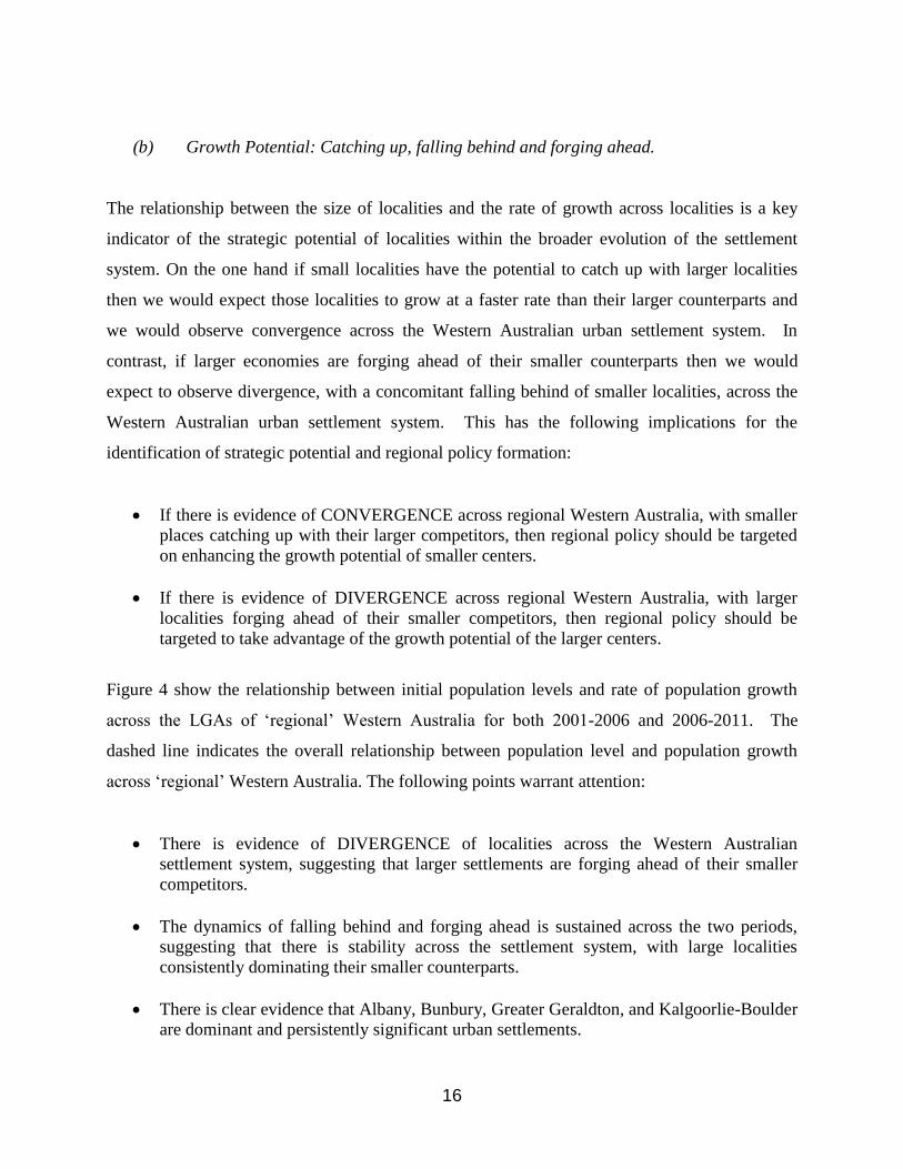
(b) Growth Potential: Catching up, falling behind and forging ahead.
The relationship between the size of localities and the rate of growth across localities is a key
indicator of the strategic potential of localities within the broader evolution of the settlement
system. On the one hand if small localities have the potential to catch up with larger localities
then we would expect those localities to grow at a faster rate than their larger counterparts and
we would observe convergence across the Western Australian urban settlement system. In
contrast, if larger economies are forging ahead of their smaller counterparts then we would
expect to observe divergence, with a concomitant falling behind of smaller localities, across the
Western Australian urban settlement system. This has the following implications for the
identification of strategic potential and regional policy formation:
If there is evidence of CONVERGENCE across regional Western Australia, with smaller
places catching up with their larger competitors, then regional policy should be targeted
on enhancing the growth potential of smaller centers.
If there is evidence of DIVERGENCE across regional Western Australia, with larger
localities forging ahead of their smaller competitors, then regional policy should be
targeted to take advantage of the growth potential of the larger centers.
Figure 4 show the relationship between initial population levels and rate of population growth
across the LGAs of ‘regional’ Western Australia for both 2001-2006 and 2006-2011. The
dashed line indicates the overall relationship between population level and population growth
across ‘regional’ Western Australia. The following points warrant attention:
There is evidence of DIVERGENCE of localities across the Western Australian
settlement system, suggesting that larger settlements are forging ahead of their smaller
competitors.
The dynamics of falling behind and forging ahead is sustained across the two periods,
suggesting that there is stability across the settlement system, with large localities
consistently dominating their smaller counterparts.
There is clear evidence that Albany, Bunbury, Greater Geraldton, and Kalgoorlie-Boulder
are dominant and persistently significant urban settlements.

17
Figure 4: Overall Population Dynamics, 2001-2006 and 2006-2011
Kalgoorlie-Boulder Bunbury
Greater Geraldton
Albany
Kalgoorlie-Boulder
Bunbury
Greater Geraldton
Albany

18
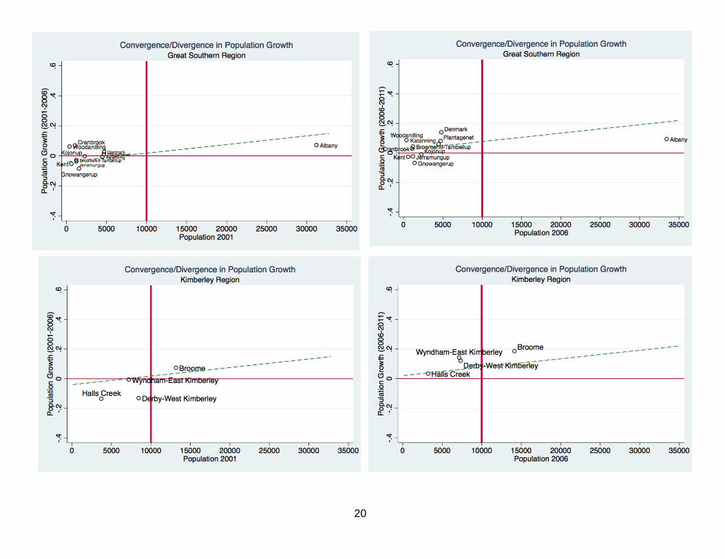
Within the broader context of regional DIVERGENCE across the Western Australian settlement
system, Figure 5 disaggregates population dynamics by Administrative/Political Region.
Combining this evidence with the hierarchical selection methodology, the following points
warrant attention:
Gascoyne does not have a regional capital.
Broome is identified as a regional capital, forging ahead more rapidly than might be
expected given the overall trajectory across regional Western Australia.
Northam is identified as regional capital, growing at rate that might be expected given the
overall trajectory across Western Australia.
Albany, Kalgoorlie-Boulder, Greater Geraldton, and Greater Bunbury are identified as
regional capitals, forging ahead if at a somewhat slower rate than might be expected
given the overall trajectory across the settlement system.
Although Esperance is a viable urban settlement and has a broadly similar growth
experience, it is dominated by Kalgoorlie-Boulder, which is accordingly identified as the
regional capital of Goldfield-Esperance.
The picture in the Pilbara region is much more complex and it is not possible to identify a
dominant regional capital. Both localities are viable urban settlements, however the
relative growth performance switching over the 2001-2011 decade. In the 2001-2006
City of Karratha dominated in terms of population growth, whilst Port Hedland
dominated the 2006-2011 period.

19
Figure 5: Population Dynamics Disaggregated by Administrative/Political Region,
20

21

22

23
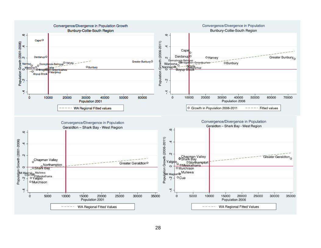
(ii) Functional Economic Regions:
(c) Viable Urban Settlements: Population and Employment
As with the regionalization based upon Administrative/Political Regions, for the functional
economic regions we focus on population dynamics to identify those localities that are both
viable urban settlements and have high growth potential. Figure 6 disaggregates population size
by Functional Economic Region. Note that for convenience some of the regions with a small
number of LGAs have been placed on the same graph and separated by a vertical line.
Based upon the selection criteria, the following points are highlighted:
There is evidence that Carnarvon-Gascoyne, Upper Great Southern and Gingin-Midland-
Greenough River, and Self Contained Labour Markets do not have a viable urban
settlement.
There are viable urban settlements in Esperance, Albany, Karratha, Broome, Greater
Geraldton, Kalgoorlie, Margaret River, Busselton, and Greater Bunbury.

24
Figure 6: Settlement Size Disaggregated by Functional Economic Region

25

26
Growth Potential: Catching up, falling behind, forging ahead
Figure 7 identifies the growth potential of each locality within each Functional Economic
Region. Based upon the selection methodology, there is a clear differentiation between the
Regional Capitals and the remainder of ‘regional’ Western Australia. Of those regions that have
identifiable and viable urban settlements there is evidence to support the contention that the
following localities are forging ahead, have high growth potential, and hence can be identified
are regional capitals:
Albany
Broome
Busselton
Esperance
Greater Geraldton
Greater Bunbury
Kalgoorlie
Northam
Port Hedland
Karratha
It is noteworthy that classifying regional capitals using Functional Economic Regions allows us
to untangle the complex population dynamics for the Pilbara Administrative/Political Region.
City of Karratha and Port Hedland are both viable urban settlements that have growth potential,
each constituting a distinct economic regions. Similarly, when considering in terms of functional
economic regions, both Esperance and Kalgoorlie-Boulder can be identified as Regional
Capitals.
Figure 7: Population Dynamics Disaggregated by Functional Economic Region

27
28

29

30

31

32
5. Implications for Regional Policy
This report identifies the regional capitals of Western Australia based upon a conceptually meaningful
method for identifying a ‘region’ and a substantively appropriate definition of what constitutes a Regional
Capital. A regional capital is defined in terms of the viability of an urban settlement and its strategic
significance in terms of growth potential within the Western Australian settlement hierarchy. To capture
the importance of both existing policy frameworks and socio-economic processes operating across the
landscape ‘regions’ are defined in terms existing Western Australia Regional Development Commission
regions and Functional Economic Regions. Using this conceptual scheme it is possible to both identify the
Regional Capitals of Western Australia and compare those regional capitals with both the remainder of
‘regional’ Western Australia and recent policy initiatives focused around Supertowns.
The recommendation that emerge from this research are clear and distinct:
(1) Using existing policy and planning frameworks Albany, Greater Bunbury (Bunbury), Kalgoorlie-
Boulder, Greater Geraldton, City of Karratha, Port Hedland, Broome, and Northam are identified as
the Regional Capitals of Western Australia.
(2) When socio-economic processes are considered, the evidence is consistent in the sense that the
members of WARCA and Northam are identified as Regional Capitals. However, Busselton and
Esperance are also identified as Regional Capitals.
(3) Esperance is the only Supertown that is also identified as a Regional Capital.
(4) In terms of both employment and population, the evidence suggests that there is a distinct and
persistent gap between the Regional Capitals and the remainder of ‘regional’ Western Australia.
(5) When considered as a whole, there is evidence that ‘regional’ Western Australia is becoming more
differentiated, with the Regional Capitals forging ahead and the rest of ‘regions’ falling behind.
(6) Taken as a whole, this evidence suggests that there needs to be a significant reorientation of regional
policy away from Supertowns and towards the Regional Capitals.