Embed Size (px)
Citation preview

Red
wo
od
Creek
P
hoto provided by K
RIS
Inform
ation
System
, and is u
sed with perm
ission
Redwood Creek Adult Spawner Targets
Downlisting to Threatened 136
Recovery
272
•Marin County Location
• 9.0 Square Miles Watershed Area
•6.8 Stream Miles Potential Habitat
•31% Coniferous, 32% Shrubland, 18% Riparian or Montane Forest, 12% Grassland
Vegetation
•Low to Moderate Erodability
•5% Private; 95% Public Ownership Patterns
•Recreational Dominant Land Uses
•Low Housing Density
•None TMDL Pollutants
Redwood Creek Coho Salmon: Nearly Extirpated Recovery Goals Conduct monitoring to track population response to recovery
action implementation
STEELHEAD: YES
CHINOOK SALMON: NO

Priority 1: Immediate Restoration Actions Priority 2 & 3: Long-Term Restoration Actions
• Develop a plan to re-establish abundance, while minimizing departure from
the genetic profile that historically existed in the population
• Evaluate supplementation strategies utilizing the existing population, or locally
adapted nearby populations within the Coastal Diversity Stratum.
• Provide incentives to water rights holders willing to convert some or all of their
water right to instream use via petition change of use and §1707
• Promote off-channel storage to reduce impacts of water diversion
• Promote conjunctive use of water with water projects whenever possible
• Fence riparian areas from grazing (using fencing standards that allow other
wildlife to access the stream)
• Decommission, upgrade, or re-locate riparian roads to upslope locations
• Evaluate and reduce nutrient and pathogen loading from upstream areas to
minimize oxygen demand
Recovery Partners
Potential Habitat: 6.8 miles Recovery Target: 272 Spawning Adult Coho Salmon
Preventing Extinction & Improving Conditions
Current Instream, Watershed and Population Conditions
Estuary/Lagoon
POOR
Habitat Complexity
FAIR
Hydrology
GOOD
Passage & Migration
VERY GOOD
Riparian Vegetation
POOR
Sediment
POOR
Stream Temperature
GOOD
Velocity Refuge
POOR
Water Quality
FAIR
Viability
POOR
Landscape Patterns
GOOD
Photo Courtesy from left to right: Josh Fuller, NMFS, Gualala River Watershed Council, Campbell Timberland, Eli Asarian and Morgan Bond, SWFSC

Conservation Highlights
• Restore habitat complexity in modified channel areas
• Implement relevant high priority treatments from the PWA assessment, and
make new recommendations for treatment. Encourage decommissioning
where feasible.
• Support efforts to remove levees on the Banducci property to create
backwater and alcove habitat
• Recreational trails should be set back from the creek and built to reduce
erosion and minimize stream crossings
• Eliminate horse access to creeks for watering or as fords
• Remove levees along Big Lagoon and Pacific Way. Address issues with
culverts, road network, and development within the Big Lagoon Area
• Work with NPS and State Parks on emergency drought operations and
contingency plans
• Work with water managers on regulated streams and other diverters to assure
adequate and proper consideration is given to fish needs.
• Adequately screen water diversions to prevent juvenile salmonid mortalities
Priority 1: Immediate Threat Abatement Actions Priority 2 & 3: Long-Term Threat Abatement Actions
Potential Habitat: 6.8 miles
Recovery Target: 272 Spawning Adult Coho Salmon
Agriculture
MEDIUM
Channel Modification
HIGH
Disease & Predation
MEDIUM
Fire & Fuel Management
MEDIUM
Fishing & Collecting
LOW
Hatcheries & Aquaculture
NA
Livestock & Ranching
MEDIUM
Logging
LOW
Mining
LOW
Recreation
MEDIUM
Urban Development
HIGH
Roads & Railroads
HIGH
Severe Weather
HIGH
Diversions & Impoundment
MEDIUM
Future Threats
Reducing Future Threats
• Estuary and floodplain restoration activities
• Agricultural Best Management Practices have been developed and implemented in the watershed
• Acquisition of key areas for the conservation of habitat
• Annual juvenile abundance surveys conducted by National Park Service provides important population data on coho salmon in the Redwood Creek watershed
A volunteer planting riparian vegetation along Redwood Creek Photo provided by KRIS Information System, and is used with permission

Redwood Creek September 2012
Figure 1: Map of Redwood Creek 601

Redwood Creek September 2012
Figure 2: Viability Results by Lifestage
0%
10%
20%
30%
40%
50%
60%
70%
80%
90%
100%
Adults Eggs Summer RearingJuveniles
Winter RearingJuveniles
Smolts Watershed Processes
Ind
icat
or
Rat
ings
Redwood CCC coho salmon- Conservation Targets
Poor Fair Good Very Good No Data
Poor= 30.6% Fair=24.2% Good= 21.0% Very Good= 19.4% No Data= 4.8%
602

Redwood Creek September 2012
Table 1: CAP Viability Results ~ Redwood Creek
Target Attribute Indicator Result Rating Method Desired Criteria
Adults Habitat ComplexityLarge Wood Frequency (BFW 0-10
meters)14.6 Key Pieces/100m Very Good NMFS Expert Estuary/Lagoon Panel 6 to 11 key pcs/100m
Adults Habitat ComplexityLarge Wood Frequency (BFW 10-100
meters)ND 0 NMFS Expert Estuary/Lagoon Panel 1.3 to 4 Key Pieces/100 meters
Adults Habitat Complexity Pool/Riffle/Flatwater Ratio50% to 74% of streams/ IP-km (>30% Pools;
>20% Riffles)Fair SEC Analysis/CDFG Data
75% to 90% of streams/ IP-Km (>30% Pools; >20%
Riffles)
Adults Habitat Complexity Shelter Rating <50% of streams/ IP-km (>80 stream average) Poor SEC Analysis/CDFG Data 75% to 90% of streams/ IP-Km (>80 stream average)
Adults Hydrology Passage Flows Risk Factor Score =50 Good SEC Analysis/CDFG Data NMFS Flow Protocol: Risk Factor Score 35-50
Adults Passage/Migration Passage at Mouth or Confluence 100% of IP-km accessible Very Good SEC Analysis/CDFG Data 75% of IP-Km to 90% of IP-km
Adults Passage/Migration Physical Barriers 100% of IP-km accessible Very Good SEC Analysis/CDFG Data 75% of IP-Km to 90% of IP-km
Adults Riparian Vegetation Tree Diameter (North of SF Bay) 0% Class 5 & 6 across IP-km Poor SEC Analysis/CDFG Data 55 - 69% Class 5 & 6 across IP-km
Adults Riparian Vegetation Tree Diameter (South of SF Bay) NA 0 SEC Analysis/CDFG Data ≥80% Density rating "D" across IP-km
Adults SedimentQuantity & Distribution of Spawning
Gravels 75% of IP-km to 90% of IP-km Good SEC Analysis/CDFG Data 75% of IP-Km to 90% of IP-km
Adults Velocity Refuge Floodplain Connectivity <50% Response Reach Connectivity Poor SEC Analysis/CDFG Data >80% Response Reach Connectivity
Adults Water Quality Toxicity Sublethal or Chronic Fair SEC Analysis/CDFG Data No Acute or Chronic
Adults Water Quality Turbidity50% to 74% of streams/ IP-km maintains severity
score of 3 or lowerFair SEC Analysis/CDFG Data
75% to 90% of streams/ IP-Km maintains severity score
of 3 or lower
Adults Viability Density <1 spawner per IP-km Poor SEC Analysis/CDFG Data low risk spawner density per Spence (2008)
Eggs Hydrology Flow Conditions (Instantaneous Condition) Risk Factor Score =42 Good SEC Analysis/CDFG Data NMFS Flow Protocol: Risk Factor Score 35-50
Eggs Hydrology Redd Scour Risk Factor Score =50 Good SEC Analysis/CDFG Data NMFS Flow Protocol: Risk Factor Score 35-50
603

Redwood Creek September 2012
Eggs Sediment Gravel Quality (Bulk) 12-14% (0.85mm) and <30% (6.4mm) Good NMFS Instream Flow Analysis 12-14% (0.85mm) and <30% (6.4mm)
Eggs Sediment Gravel Quality (Embeddedness)0% streams 0% IP-km (>50% stream average
scores of 1 & 2)Poor NMFS Instream Flow Analysis
75% to 90% of streams/ IP-Km (>50% stream average
scores of 1 & 2)
Summer Rearing Juveniles Estuary/Lagoon Quality & Extent Impaired/non-functional Poor NMFS Instream Flow Analysis Properly Functioning Condition
Summer Rearing Juveniles Habitat ComplexityLarge Wood Frequency (Bankfull Width 0-
10 meters)14.6 Key Pieces/100m Very Good NMFS Instream Flow Analysis 6 to 11 key pcs/100m
Summer Rearing Juveniles Habitat ComplexityLarge Wood Frequency (Bankfull Width
10-100 meters)ND 0 NMFS Instream Flow Analysis 1.3 to 4 Key Pieces/100 meters
Summer Rearing Juveniles Habitat Complexity Percent Primary Pools0% streams 0% IP-km (>50% stream average
scores of 1 & 2)Fair NMFS Instream Flow Analysis
75% to 89% of streams/ IP-Km (>49% of pools are
primary pools)
Summer Rearing Juveniles Habitat Complexity Pool/Riffle/Flatwater Ratio50% to 74% of streams/ IP-km (>30% Pools;
>20% Riffles)Fair NMFS Instream Flow Analysis
75% to 90% of streams/ IP-Km (>30% Pools; >20%
Riffles)
Summer Rearing Juveniles Habitat Complexity Shelter Rating <50% of streams/ IP-km (>80 stream average) Poor NMFS Instream Flow Analysis 75% to 90% of streams/ IP-Km (>80 stream average)
Summer Rearing Juveniles Hydrology Flow Conditions (Baseflow) Risk Factor Score =51-75 Fair NMFS Instream Flow Analysis NMFS Flow Protocol: Risk Factor Score 35-50
Summer Rearing Juveniles Hydrology Flow Conditions (Instantaneous Condition) Risk Factor Score =42 Good NMFS Watershed Characterization NMFS Flow Protocol: Risk Factor Score 35-50
Summer Rearing Juveniles HydrologyNumber, Condition and/or Magnitude of
Diversions8.76 Diversions/10 IP-km Poor NMFS Watershed Characterization 0.01 - 1 Diversions/10 IP km
Summer Rearing Juveniles Passage/Migration Passage at Mouth or Confluence 100% of IP-km accessible Very Good NMFS Watershed Characterization 75% of IP-Km to 90% of IP-km
Summer Rearing Juveniles Passage/Migration Physical Barriers 100% of IP-km accessible Very Good Population Profile/BPJ 75% of IP-Km to 90% of IP-km
Summer Rearing Juveniles Riparian Vegetation Canopy Cover96% of streams/ IP-km (>85% average stream
canopy)Very Good SEC or PAD/CDFG Data
75% to 90% of streams/ IP-Km (>85% average stream
canopy)
Summer Rearing Juveniles Riparian Vegetation Tree Diameter (North of SF Bay) 0% Class 5 & 6 across IP-km Poor Population Profile/BPJ 55 - 69% Class 5 & 6 across IP-km
Summer Rearing Juveniles Riparian Vegetation Tree Diameter (South of SF Bay) NA 0 SEC or PAD/CDFG Data ≥80% Density rating "D" across IP-km
Summer Rearing Juveniles Sediment (Food Productivity) Gravel Quality (Embeddedness)50% to 74% of streams/ IP-km (>50% stream
average scores of 1 & 2)Fair SEC or PAD/CDFG Data
75% to 90% of streams/ IP-Km (>50% stream average
scores of 1 & 2)
604

Redwood Creek September 2012
Summer Rearing Juveniles Water Quality Temperature (MWMT) 75 to 89% IP-km (<16 C MWMT) Good Population Profile/BPJ 75 to 89% IP km (<16 C MWMT)
Summer Rearing Juveniles Water Quality Toxicity Sublethal or Chronic FairNMFS Watershed
Characterization/CWHRNo Acute or Chronic
Summer Rearing Juveniles Water Quality Turbidity75% to 90% of streams/ IP-km maintains severity
score of 3 or lowerGood
NMFS Watershed
Characterization/CWHR
75% to 90% of streams/ IP-Km maintains severity score
of 3 or lower
Summer Rearing Juveniles Viability Density 0.2 fish/meter̂ 2 Poor SEC Analysis/CDFG Data 0.5 - 1.0 fish/meter^2
Summer Rearing Juveniles Viability Spatial Structure 50-74% of Historical Range FairNMFS Watershed
Characterization/CWHR75-90% of Historical Range
Winter Rearing Juveniles Habitat ComplexityLarge Wood Frequency (Bankfull Width 0-
10 meters)14.6 Key Pieces/100m Very Good
NMFS Watershed
Characterization/CWHR6 to 11 key pcs/100m
Winter Rearing Juveniles Habitat ComplexityLarge Wood Frequency (Bankfull Width
10-100 meters)ND 0
NMFS Watershed
Characterization/CWHR1.3 to 4 Key Pieces/100 meters
Winter Rearing Juveniles Habitat Complexity Pool/Riffle/Flatwater Ratio50% to 74% of streams/ IP-km (>30% Pools;
>20% Riffles)Fair
NMFS Watershed
Characterization/CWHR
75% to 90% of streams/ IP-Km (>30% Pools; >20%
Riffles)
Winter Rearing Juveniles Habitat Complexity Shelter Rating <50% of streams/ IP-km (>80 stream average) Poor CDF Vegetation Maps/BPJ 75% to 90% of streams/ IP-Km (>80 stream average)
Winter Rearing Juveniles Passage/Migration Physical Barriers 100% of IP-km accessible Very Good Population Profile/BPJ 75% of IP-Km to 90% of IP-km
Winter Rearing Juveniles Riparian Vegetation Tree Diameter (North of SF Bay) 0% Class 5 & 6 across IP-km Poor Population Profile/BPJ 55 - 69% Class 5 & 6 across IP-km
Winter Rearing Juveniles Riparian Vegetation Tree Diameter (South of SF Bay) NA 0 SEC Analysis/CDFG Data ≥80% Density rating "D" across IP-km
Winter Rearing Juveniles Sediment (Food Productivity) Gravel Quality (Embeddedness)50% to 74% of streams/ IP-km (>50% stream
average scores of 1 & 2)Fair SEC Analysis/CDFG Data
75% to 90% of streams/ IP-Km (>50% stream average
scores of 1 & 2)
Winter Rearing Juveniles Velocity Refuge Floodplain Connectivity <50% Response Reach Connectivity Poor SEC Analysis/CDFG Data >80% Response Reach Connectivity
Winter Rearing Juveniles Water Quality Toxicity Sublethal or Chronic Fair NMFS Watershed Characterization No Acute or Chronic
Winter Rearing Juveniles Water Quality Turbidity<50% of streams/ IP-km maintains severity score
of 3 or lowerPoor NMFS Watershed Characterization
75% to 90% of streams/ IP-Km maintains severity score
of 3 or lower
605

Redwood Creek September 2012
Smolts Estuary/Lagoon Quality & Extent Impaired but functioning Fair SEC Analysis/CDFG Data Properly Functioning Condition
Smolts Habitat Complexity Shelter Rating <50% of streams/ IP-km (>80 stream average) Poor Population Profile 75% to 90% of streams/ IP-Km (>80 stream average)
Smolts HydrologyNumber, Condition and/or Magnitude of
Diversions1.1 - 5 Diversions/10 IP-km Fair Population Profile 0.01 - 1 Diversions/10 IP km
Smolts Hydrology Passage Flows Risk Factor Score =50 Good TRT Spence (2008) NMFS Flow Protocol: Risk Factor Score 35-50
Smolts Passage/Migration Passage at Mouth or Confluence 100% of IP-km accessible Very Good TRT Spence (2008) 75% of IP-Km to 90% of IP-km
Smolts Smoltification Temperature 75-90% IP-km (>6 and <16 C) Good TRT Spence (2008) 75-90% IP-Km (>6 and <16 C)
Smolts Water Quality Toxicity Sublethal or Chronic Fair TRT Spence (2008) No Acute or Chronic
Smolts Water Quality Turbidity<50% of streams/ IP-km maintains severity score
of 3 or lowerPoor EPA/RWQCB/NMFS Criteria
75% to 90% of streams/ IP-Km maintains severity score
of 3 or lower
Smolts Viability Abundance Abundance leading to high risk spawner density = 0 Poor Newcombe and Jensen 2003 Smolt abundance to produce low risk spawner density
per Spence (2008)
Watershed Processes Hydrology Impervious Surfaces 1.3% of Watershed in Impervious Surfaces Very Good SEC Analysis 3-6% of Watershed in Impervious Surfaces
Watershed Processes Landscape Patterns Agriculture 0.88% of Watershed in Agriculture Very Good EPA/RWQCB/NMFS Criteria 10-19% of Watershed in Agriculture
Watershed Processes Landscape Patterns Timber Harvest 25-15% of Watershed in Timber Harvest Good Newcombe and Jensen 2003 25-15% of Watershed in Timber Harvest
Watershed Processes Landscape Patterns Urbanization 9% of watershed >1 unit/20 acres Good EPA/RWQCB/NMFS Criteria 8-11% of watershed >1 unit/20 acres
Watershed Processes Riparian Vegetation Species Composition 51-74% Intact Historical Species Composition Good Newcombe and Jensen 2003 51-74% Intact Historical Species Composition
Watershed Processes Sediment Transport Road Density 4.1 Miles/Square Mile Poor EPA/RWQCB/NMFS Criteria 1.6 to 2.4 Miles/Square Mile
Watershed Processes Sediment Transport Streamside Road Density (100 m) 4.9 Miles/Square Mile Poor Newcombe and Jensen 2003 0.1 to 0.4 Miles/Square Mile
606

Redwood Creek September 2012
Table 2: CAP Threats Results ~ Redwood Creek
Threats Across Targets Adults Eggs
Summer
Rearing
Juveniles
Winter
Rearing
Juveniles
Smolts Watershed
Processes
Overall Threat
Rank
Project-specific threats 1 2 3 4 5 6
1 Agriculture Low Medium Medium Medium Medium High Medium
2 Channel Modification High Medium Medium High Medium High High
3 Disease, Predation and Competition Medium - Medium Medium Low Low Medium
4 Fire, Fuel Management and Fire Suppression Low Low Medium Medium Low Medium Medium
5 Fishing and Collecting Medium - Low - Low - Low
6 Hatcheries and Aquaculture - - - - - - -
7 Livestock Farming and Ranching Medium Medium Medium Medium Medium Medium Medium
8 Logging and Wood Harvesting Low Low Low Low Low Medium Low
9 Mining Low Low Low Low Low Medium Low
10 Recreational Areas and Activities Low Low Medium Medium Low Low Medium
11 Residential and Commercial Development Medium Medium High High Medium Medium High
12 Roads and Railroads Medium High Medium High High High High
13 Severe Weather Patterns Medium Medium High High Medium High High
14 Water Diversion and Impoundments Medium Low High Medium Medium Medium Medium
Threat Status for Targets and Project High High High High High High High
607

Redwood Creek September 2012
Central CA Coast Coho Salmon ~ Redwood Creek
ACTIONS FOR RESTORING HABITATS
1. Restoration- Estuary
1.1. Objective: Address the present or threatened destruction, modification, or curtailment of the species habitat or
range
1.1.1. Recovery Action: Improve the quality and extent of freshwater lagoon habitat
1.1.1.1. Action Step: Enhance and restore estuary function by improving complex habitat features.
1.1.1.2. Action Step: Continue restoration efforts on Big Lagoon to benefit coho salmon during all life
stages and seasons.
1.1.1.3. Action Step: Where appropriate, remove structures and/or modify practices which impair or
reduce the historical tidal prism and/or estuarine function where feasible and where benefits to
coho salmon and/or the estuarine environment are predicted.
1.1.1.4. Action Step: Support efforts of NPS to restore functional floodplain and lagoon habitat in the
lower portion of the watershed.
2. Restoration- Floodplain Connectivity
2.1. Objective: Address the inadequacy of existing regulatory mechanisms
2.1.1. Recovery Action: Prevent impairment to floodplain connectivity.
2.1.1.1. Action Step: Encourage willing landowners to restore historical floodplains or offchannel
habitats through conservation easements, etc.
2.1.1.2. Action Step: Existing areas with floodplains or off channel habitats should be protected from
future urban development of any kind.
2.1.1.3. Action Step: Purchase land/conservation easements to encourage the re-establishment and/or
enhancement of natural riparian communities.
2.1.1.4. Action Step: Evaluate, develop solutions and implement immediate needs to address
problems resulting from channelization.
2.2. Objective: Address the present or threatened destruction, modification, or curtailment of the species habitat or
range
2.2.1. Recovery Action: Increase and enhance velocity refuge
2.2.1.1. Action Step: Delineate reaches possessing both potential winter rearing habitat and floodplain
areas.
2.2.1.2. Action Step: Target habitat restoration and enhancement that will function between winter
base flow and flood stage.
2.2.1.3. Action Step: Promote restoration projects designed to create or restore alcove, backchannel,
ephemeral tributary, or seasonal pond habitats.
608

Redwood Creek September 2012
2.2.1.4. Action Step: Identify potential sites for construction/restoration of alcoves, backwaters, etc.
based on land use and geomorphic constraints.
2.2.1.5. Action Step: Support efforts to remove levees on the Banducci property to create backwater
and alcove habitat by having the county raise the lower section of Muir Woods road where it
meets Highway One. Raising the road will address flooding and create vital off channel habitat
in this section of creek. Coordinate with the NMFS and/or CDFG geomorphologist on design
features and implementation techniques.
2.2.1.6. Action Step: Restore connectivity and enhance habitat in Green Gulch.
2.2.1.7. Action Step: Remove riprap and gabion rock at lowest end of watershed.
2.2.1.8. Action Step: Continue to monitor restored reaches in the “Bowling Alley” and “Upper Alley”
sections to promote off channel habitat formation. Consult with NMFS and or CDFG
geomorphologist before and during the design and implementation phase.
3. Restoration- Habitat Complexity
3.1. Objective: Address the present or threatened destruction, modification, or curtailment of the species habitat or
range
3.1.1. Recovery Action: Increase large wood frequency (BFW 0-10 meters)
3.1.1.1. Action Step: Incorporate large woody material into stream bank protection projects, where
appropriate. Do not use aqua logs (cylindrical concrete rip rap).
3.1.1.2. Action Step: Place unsecured LWD in the stream and monitor how it is distributed in the
watershed.
3.1.1.3. Action Step: Install properly sized large woody debris to appropriate viability table targets.
3.1.1.4. Action Step: Assess and prioritize restoration of channelized sections to enhance pool depths
in Redwood Creek through Muir Woods while maintaining the historic resource to the greatest
degree possible.
3.1.1.5. Action Step: Engage in riprap removal and LWD placement to restore channel processes
within the Muir Woods National Monument as per Kimbell and Kondolf, 2002.
3.1.2. Recovery Action: Improve habitat complexity
3.1.2.1. Action Step: Evaluate the potential and specific locations (e.g. State and Federal lands) for the
re-location and re-introduction of beaver populations
3.1.3. Recovery Action: Improve shelter rating
3.1.3.1. Action Step: Increase shelter ratings in 75% of streams across the watershed to improve
conditions for adults, and winter/summer rearing juveniles
3.2. Objective: Address the inadequacy of existing regulatory mechanisms
3.2.1. Recovery Action: Prevent the loss of habitat complexity
609

Redwood Creek September 2012
3.2.1.1. Action Step: Educate landowners, land managers, and County and municipal staffs on the
importance of LWD to coho survival and recovery, and watershed processes.
3.2.1.2. Action Step: Implement education programs and modify policies and procedures to improve
riparian corridor protection, maintain channel integrity, implement alternatives to hard bank
protection, and retain large woody debris.
3.2.1.3. Action Step: Fully implement the Programmatic Section 7 consultation for restoration projects
administered by the NOAA Restoration Center that permits placement of instream large
woody debris.
4. Restoration- Hydrology
4.1. Objective: Address the present or threatened destruction, modification, or curtailment of the species habitat or
range
4.1.1. Recovery Action: Improve flow conditions (baseflow conditions)
4.1.1.1. Action Step: Assess and map water diversions (CDFG 2004).
4.1.1.2. Action Step: Establish a comprehensive stream flow evaluation program to determine
instream flow needs for coho salmon.
4.1.1.3. Action Step: Provide incentives to water rights holders willing to convert some or all of their
water right to instream use via petition change of use and §1707 (CDFG 2004).
4.1.2. Recovery Action: Improve passage flows
4.2. Objective: Address the inadequacy of existing regulatory mechanisms
4.2.1. Recovery Action: Improve flow conditions (baseflow conditions)
4.2.1.1. Action Step: Maintain water operations agreements between NPS, CDFG, and MBCSD to
operate in a manner that does not alter summer surface flow
4.2.1.2. Action Step: Promote off-channel storage to reduce impacts of water diversion (e.g. storage
tanks for rural residential users).
4.2.1.3. Action Step: Promote conjunctive use of water with water projects whenever possible to
maintain or restore coho salmon habitat.
4.2.1.4. Action Step: Identify and eliminate depletion of summer base flows from unauthorized water
uses.
4.2.1.5. Action Step: Improve coordination between agencies and others to address season of
diversion, off-stream reservoirs, bypass flows protective of coho salmon and their habitats, and
avoidance of adverse impacts caused by water diversion (CDFG 2004).
4.2.2. Recovery Action: Improve passage flows
4.2.2.1. Action Step: Promote passive diversion devices designed to allow diversion of water only
when minimum streamflow requirements are met or exceeded (CDFG 2004).
610

Redwood Creek September 2012
4.2.2.2. Action Step: Evaluate requests for on-stream dams above coho migratory reaches for effects on
the natural hydrograph and the supply of spawning gravel for recruitment downstream (CDFG
2004).
4.2.2.3. Action Step: Encourage compliance with the most recent update of NMFS' Water Diversion
Guidelines.
5. Restoration- Landscape Patterns
No species-specific actions were developed.
6. Restoration- Passage
No species-specific actions were developed.
7. Restoration- Pool Habitat
No species-specific actions were developed. See Habitat Complexity
8. Restoration- Riparian
8.1. Objective: Address the present or threatened destruction, modification or curtailment of the species habitat or
range
8.1.1. Recovery Action: Improve canopy cover
8.1.1.1. Action Step: Assess riparian canopy and impacts of exotic vegetation (e.g., Arundo donax,
etc.), prioritize and develop riparian habitat reclamation and enhancement programs (CDFG
2004).
8.1.1.2. Action Step: Fence riparian areas from grazing (using fencing standards that allow other
wildlife to access the stream).
8.1.1.3. Action Step: Locate water sources away from riparian areas.
8.1.1.4. Action Step: Plant native vegetation to promote streamside shade.
8.1.1.5. Action Step: Promote bio-engineering solutions as appropriate (e.g. where critical
infrastructure is located) for bank hardening projects.
8.1.2. Recovery Action: Improve tree diameter
8.1.2.1. Action Step: Increase tree diameter within 55% of watershed to achieve optimal riparian forest
conditions (55 - 69% Class 5 & 6 tree)
8.1.2.2. Action Step: Improve the structure and composition of riparian areas to provide shade, large
woody debris input, nutrient input, bank stabilization, and other CCC coho salmon needs.
8.1.2.3. Action Step: Encourage programs to purchase land/conservation easements to re-establish and
enhance natural riparian communities.
8.2. Objective: Address the inadequacy of existing regulatory mechanisms
8.2.1. Recovery Action: Protect existing riparian areas
611

Redwood Creek September 2012
8.2.1.1. Action Step: Promote streamside conservation measures, including conservation easements,
setbacks, and riparian buffers (DFG 2004).
8.2.1.2. Action Step: Review and develop preferred protocols for Pierce's Disease Control that would
maintain a native riparian corridor and develop an outreach program (CDFG 2004).
9. Restoration- Sediment
9.1. Objective: Address the present or threatened destruction, modification, or curtailment of the species habitat or
range
9.1.1. Recovery Action: Improve instream gravel quality
9.1.1.1. Action Step: Conduct road and sediment reduction assessments to identify sediment-related
and runoff-related problems and determine level of hydrologic connectivity.
9.1.1.2. Action Step: Address high and medium priority sediment delivery sites
9.1.1.3. Action Step: Decommission riparian road systems and/or upgrade roads (and skid trails on
forestlands) that deliver sediment into adjacent watercourses (CDFG 2004).
9.1.1.4. Action Step: Establish and/or maintain continuous native riparian buffers.
9.1.1.5. Action Step: Fence riparian areas from grazing (using fencing standards that allow other
wildlife to access the stream).
9.2. Objective: Address the inadequacy of existing regulatory mechanisms
9.2.1. Recovery Action: Improve instream gravel quality
9.2.1.1. Action Step: Limit winter use of unsurfaced roads and recreational trails by unauthorized and
impacting uses to decrease fine sediment loads.
9.2.1.2. Action Step: Use available best management practices for road construction, maintenance,
management and decommissioning (e.g. Weaver and Hagans, 1994; Sommarstrom et al., 2002;
Oregon Department of Transportation, 1999).
10. Restoration- Viability
10.1. Objective: Address the present or threatened destruction, modification, or curtailment of the species habitat or
range.
10.1.1. Recovery Action: Increase abundance
10.1.1.1. Action Step: Develop a plan to re-establish abundance, while minimizing departure from the
genetic profile that historically existed in the population.
10.1.1.2. Action Step: Evaluate supplementation strategies utilizing the existing population, or locally
adapted nearby populations within the DS, while minimizing departure from the genetic
profile that historically existed in the population.
10.1.2. Recovery Action: Monitor population status.
612

Redwood Creek September 2012
10.1.2.1. Action Step: Conduct upslope watershed assessments to define limiting factors. Encourage all
major landowners to participate
10.1.2.2. Action Step: Conduct an instream habitat assessment to develop restoration recommendations
10.1.3. Recovery Action: Increase spawner density
10.1.3.1. Action Step: Develop and implement a monitoring program to evaluate the performance of
recovery efforts.
10.1.4. Recovery Action: Increase spatial structure and diversity
10.1.4.1. Action Step: Continue to rescue juvenile coho salmon with existing permittees that are under
an imminent risk of stranding and mortality and relocate to suitable habitat when deemed
appropriate by NMFS and CDFG
10.1.4.2. Action Step: Utilize broodstock from Marin County to repopulate remaining extirpated
streams within the watershed.
10.1.4.3. Action Step: Conduct outreach with landowners to expand broodstock releases within core
areas, and remaining extirpated streams within the watershed
11. Restoration- Water Quality
11.1. Objective: Address the present or threatened destruction, modification, or curtailment of the species habitat or
range
11.1.1. Recovery Action: Improve stream water quality conditions
11.1.1.1. Action Step: Conduct conifer release to promote growth of larger diameter trees where
appropriate.
11.1.1.2. Action Step: Improve riparian and instream conditions in rearing habitats by establishing
riparian protection zones that extend the distance of a site potential tree height from the outer
edge of a channel, and by adding LWD.
11.1.1.3. Action Step: Promote streamside conservation measures, including conservation easements,
setbacks, and riparian buffers (DFG 2004).
11.2. Objective: Address the inadequacy of existing regulatory mechanisms.
11.2.1. Recovery Action: Improve stream water quality conditions
11.2.1.1. Action Step: Evaluate and reduce nutrient and pathogen loading from upstream areas to
minimize oxygen demand in lower Redwood Creek.
THREAT ABATEMENT ACTIONS
12. Threat- Agricultural Practices
No species-specific actions were developed.
13. Threat- Channel Modification
613

Redwood Creek September 2012
13.1. Objective: Address the present or threatened destruction, modification, or curtailment of the species habitat or
range
13.1.1. Recovery Action: Prevent impairment of floodplain connectivity
13.1.1.1. Action Step: Conduct education with public works staff in this area relative to Fishnet 4C
Roads Manual
13.1.1.2. Action Step: Where feasible, remove obsolete bank stabilization structures from the channel
which contribute to channel incision and reduced habitat complexity.
13.1.1.3. Action Step: Prevent additional channel modification or utilize BMP's to address flood control
or bank stabilization issue
13.1.1.4. Action Step: Thoroughly investigate the ultimate cause of channel instability prior to engaging
in site specific channel modifications and maintenance. Identify and target remediation of
watershed process disruption as an overall priority.
13.1.1.5. Action Step: Promote bio-engineering solutions as appropriate (e.g. except where critical
infrastructure is located) for bank hardening projects.
13.1.1.6. Action Step: Restore habitat complexity in modified channel areas
14. Threat- Disease/Predation/Competition
No species-specific actions were developed.
15. Threat- Fire/Fuel Management
15.1. Objective: Address the present or threatened destruction, modification, or curtailment of the species habitat or
range
15.1.1. Recovery Action: Prevent adverse alterations to riparian species composition and structure
15.1.1.1. Action Step: Identify historical fire frequency, intensities and durations and manage fuel loads
in a manner consistent with historical parameters.
15.1.1.2. Action Step: Conduct fuel load monitoring and compare the results to estimated historical fuel
loads.
15.1.2. Recovery Action: Prevent impairment to water quality
15.1.2.1. Action Step: Avoid use of aerial fire retardants and foams within 300 feet of riparian areas
throughout the current range of CCC coho salmon.
15.1.3. Recovery Action: Prevent impairment to water quality (increased turbidity, suspended sediment,
and/or toxicity)
15.1.3.1. Action Step: Immediately implement appropriate sediment control measures following
completion of fire suppression while firefighters and equipment are on site.
16. Threat- Fishing/Collecting
No species-specific actions were developed.
614

Redwood Creek September 2012
17. Threat- Hatcheries
No species-specific actions were developed.
18. Threat- Livestock
No species-specific actions were developed.
19. Threat- Logging
No species-specific actions were developed.
20. Threat- Mining
No species-specific actions were developed.
21. Threat- Recreation
21.1. Objective: Address the present of threatened destruction, modification or curtailment of the species habitat or
range
21.1.1. Recovery Action: Prevent impairment to water quality (increased turbidity, suspended sediment,
and/or toxicity)
21.1.1.1. Action Step: Evaluate trail crossings to ensure bridges are constructed to support horses.
21.1.1.2. Action Step: Eliminate horse access to creeks for watering or as fords.
21.1.1.3. Action Step: Increase education to the equestrian community regarding impacts to riparian
and instream habitat from horse manure and hooves.
21.1.1.4. Action Step: Recreational trails should be set back from the creek and built to reduce erosion
and minimize stream crossings.
22. Threat- Residential/Commercial Development
22.1. Objective: Address the present or threatened destruction, modification or curtailment of the species habitat or
range
22.1.1. Recovery Action: Prevent impairment to watershed hydrology
22.1.1.1. Action Step: Implement actions in ROADS and RAILROADS
22.1.1.2. Action Step: Implement DS level Actions
22.1.2. Recovery Action: Prevent impairment to floodplain connectivity
22.1.2.1. Action Step: Implement actions in FLOODPLAIN
22.1.2.2. Action Step: Implement DS level actions
22.1.3. Recovery Action: Prevent impairment to riparian species and composition
22.1.3.1. Action Step: Implement actions in RIPARIAN
22.1.4. Recovery Action: Prevent impairment to stream hydrology (impaired water flow)
22.1.4.1. Action Step: Implement actions in WATER DIVERSIONS
615

Redwood Creek September 2012
22.1.4.2. Action Step: Implement DS level actions
22.2. Objective: Address the inadequacy of existing regulatory mechanisms.
22.2.1. Recovery Action: Prevent increased landscape disturbance
22.2.1.1. Action Step: Implement DS level actions and BMP's
23. Threat- Roads/Railroads
23.1. Objective: Address the present or threatened destruction, modification, or curtailment of the species habitat or
range
23.1.1. Recovery Action: Prevent alterations to sediment transport (road condition/density, dams, etc.)
23.1.1.1. Action Step: Revaluate the high priority treatment recommendations for unpaved roads from
the PWA assessment, and implement recommended treatments if they are still relevant. If not,
reassess and make new recommendations for treatment. Push for decommissioning when
feasible.
23.1.1.2. Action Step: Bridges associated with new roads or replacement bridges (including railroad
bridges) should be free span or constructed with the minimum number of bents feasible in
order to minimize drift accumulation and facilitate fish passage.
23.1.2. Recovery Action: Prevent impairment to water quality (increased turbidity, suspended sediment,
and/or toxicity)
23.1.2.1. Action Step: NMFS and other stakeholders will work with RCD or NRCS to encourage hiring
of consultants to conduct road assessments (first for subwatersheds in Core areas, then for
Phase I areas).
23.1.2.2. Action Step: Address sediment sources from road networks and other actions that deliver
sediment to stream channels.
23.1.2.3. Action Step: Reduce road densities by 10 percent over the next 10 years, prioritizing high risk
areas in historical habitats or Core CCC coho salmon watersheds.
23.1.3. Recovery Action: Prevent impairment to the estuary (impaired quality and extent)
23.1.3.1. Action Step: Support efforts to remove levees on the Banducci property to create backwater
and alcove habitat by having the county raise the lower section of Muir Woods road where it
meets Highway One. Raising the road will address flooding and create vital off channel habitat
in this section of creek. Coordinate with the NMFS and/or CDFG geomorphologist on design
features and implementation techniques.
23.1.3.2. Action Step: Remove levees along Big Lagoon and Pacific Way. Address issues with culverts,
road network, and development within the Big Lagoon Area.
23.2. Objective: Address the inadequacy of existing regulatory mechanisms
23.2.1. Recovery Action: Prevent impairment to water quality (increased turbidity, suspended sediment,
and/or toxicity)
616

Redwood Creek September 2012
23.2.1.1. Action Step: Use available best management practices for road construction, maintenance,
management and decommissioning (e.g. Weaver and Hagans, 1994; Sommarstrom et al., 2002;
Oregon Department of Transportation, 1999).
24. Threat- Severe Weather Patterns
24.1. Objective: Address the inadequacy of existing regulatory mechanisms
24.1.1. Recovery Action: Prevent impairment to hydrology
24.1.1.1. Action Step: Work with NPS and State Parks on emergency drought operations and
contingency plans (i.e. fish rescues etc.)
24.1.1.2. Action Step: Work with CDFG, Counties, other agencies, and knowledgeable biologists to
develop emergency rules and adopt implementation agreements.
24.1.1.3. Action Step: Work with water managers on regulated streams to assure adequate and proper
consideration is given to fish needs. Develop agreements, which will minimize water-use
conflicts and impacts on fish and wildlife resources during drought conditions.
24.1.1.4. Action Step: Encourage SWRCB to bring illegal water diverters and out-of-compliance
diverters into compliance with State law.
25. Threat- Water Diversion/Impoundment
25.1. Objective: Address the present or threatened destruction, modification or curtailment of the species habitat or
range
25.1.1. Recovery Action: Prevent impairment to stream hydrology (impaired water flow)
25.1.1.1. Action Step: Work with the Muir Beach CSD and Green Gulch farm to eliminate water
diversions that affect flow within Redwood Creek.
25.1.1.2. Action Step: Provide incentives to water rights holders willing to convert some or all of their
water right to instream use via petition change of use and §1707 (CDFG 2004).
25.1.2. Recovery Action: Prevent reduced density, abundance, and diversity
25.1.2.1. Action Step: Adequately screen water diversions to prevent juvenile salmonid mortalities.
25.2. Objective: Address the inadequacy of existing regulatory mechanisms
25.2.1. Recovery Action: Prevent impairment to stream hydrology (impaired water flow)
25.2.1.1. Action Step: Support SWRCB in regulating the use of streamside wells and groundwater.
25.2.1.2. Action Step: Improve coordination between agencies and others to address season of
diversion, off-stream reservoirs, bypass flows protective of coho salmon and their habitats, and
avoidance of adverse impacts caused by water diversion (CDFG 2004).
25.2.1.3. Action Step: Identify and work with the SWRCB to eliminate depletion of summer base flows
from unauthorized water uses. Coordinated efforts by Federal and State, and County law
enforcement agencies to remove illegal diversions from streams.
617

Redwood Creek September 2012
26. Threat- Watershed Process
No species-specific actions were developed.
618

Redwood Creek September 2012
Table 3: Implementation Table ~ Redwood Creek
619
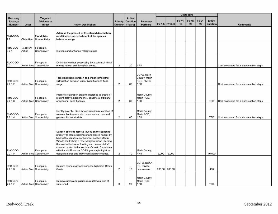
Redwood Creek September 2012 620

Redwood Creek September 2012 621

Redwood Creek September 2012 622
Redwood Creek September 2012 623
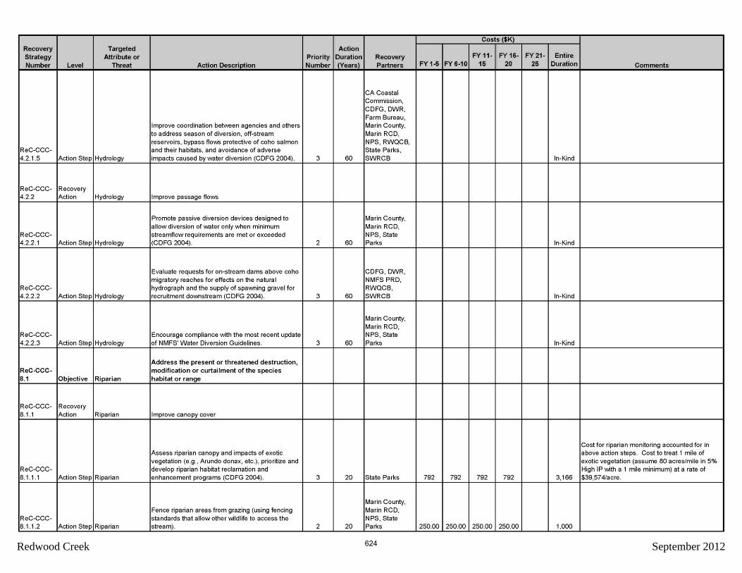
Redwood Creek September 2012 624

Redwood Creek September 2012 625

Redwood Creek September 2012 626

Redwood Creek September 2012 627

Redwood Creek September 2012 628

Redwood Creek September 2012 629

Redwood Creek September 2012 630

Redwood Creek September 2012 631

Redwood Creek September 2012 632

Redwood Creek September 2012 633

Redwood Creek September 2012
634


