Embed Size (px)
Citation preview

Red River of the North
Fisheries Management Plan
Minnesota Department of Natural Resources
North Dakota Game and Fish Department
Manitoba Water Stewardship
South Dakota Department of Game, Fish and Parks
April 2008 - 2012


Red River of the North
Fisheries Management Plan
1
I. Red River of the North Description
The hydrologic headwaters of Red River of the North (Red River) originate in the upper portions
of the Otter Tail River watershed. Red River of the North, by name, begins at the confluence of
the Bois de Sioux and Otter Tail rivers and flows northward approximately 545 miles through
the bed of glacial Lake Agassiz where it empties into Lake Winnipeg (Figure 1). The upstream
400 miles of Red River forms the Minnesota-North Dakota border and the downstream 145 miles
flow through southern Manitoba, Canada.
Red River has a watershed area of approximately 45,000 square miles excluding the Assiniboine
River basin, which joins Red River at Winnipeg. Twenty-one primary subwatersheds located in
North Dakota, Minnesota, and Manitoba empty into Red River (Figure 1). Approximately
46.6% of the Red River watershed (21,000 mi2) lies in North Dakota, 38.9% (17,500 mi
2) in
Minnesota, 12.7% (5,700 mi2) in Manitoba and 1.8% (810 mi
2) in South Dakota (Eddy et al.
1972). Land use throughout the basin is dominated by agricultural practices.
Red River is a highly sinuous, low gradient warmwater river with an extensive floodplain.
Stream sinuosity through the U.S. portion of Red River averages 2.0, ranging from 1.6 to 2.6
through the different segments. Stream gradient varies from 0.2 to 1.3 ft/mile (Renard et al.
1986). The highest gradient segment (1.3 ft/mi) is found between river mile (RM) 398 and
RM380 just downstream from the former dam site at Wahpeton, ND/Breckenridge, MN (Figure
2). The next highest gradient segment (gradient = 0.9 ft/mi) is located from RM226 to RM181
between the confluences with Wild Rice River, Minnesota, and Sand Hill River, MN. Eight
dams have been built on the mainstem of Red River in the U.S. and these reduce the gradient
through many segments. For instance, the construction of the Midtown and North dams in
Fargo, ND, reduced the stream gradient through that stretch of river from its original 1.8 ft/mile
to the present 0.2 ft/mile. As would be expected, the higher gradient segments contain the most
riffles. Renard et al. (1986) reported the segment from RM226 to RM181 contained 15
individual riffles and the segment from RM398 to RM380 contained 4 riffles. Red River
averages approximately 150 feet wide in the upstream segments and approximately 250 feet
wide in the lower segments. Water depths reach a maximum of approximately 30 feet.
Mean annual flow for Red River at Wahpeton, ND, is 657 cubic feet per second (cfs) and
increases to 4,514 cfs at Drayton, ND (USGS), and to approximately 8,400 cfs at Lake Winnipeg
(Aadland et al. 2005). The majority of Red River’s annual flow comes from the eastern
tributaries as a result of regional patterns of precipitation, evapotranspiration, soils, and
topography (Stoner et al. 1993). Most runoff occurs in spring and early summer as a result of
rains falling on melting snow or heavy rains falling on saturated soils.
Five of the eight dams on the U.S. segment of mainstem Red River have been converted into
rock-arch rapids in order to allow for fish passage, remove erosive hydraulic currents and reduce
public safety hazards (Figure 2). The three remaining, unmodified dams are located near the
towns of Christine, Hickson and Drayton, ND. One additional dam lies on the Canadian segment
of mainstem Red River at Lockport, Manitoba.

Red River of the North
Fisheries Management Plan
2
Figure 1. Primary rivers and streams of the Red River basin.
North Dakota 1. Wild Rice River
2. Sheyenne River
3. Maple River
4. Elm River
5. Goose River
6. Turtle River
7. Forest River
8. Park River
9. Pembina River
Minnesota 10. Bois de Sioux River
11. Otter Tail River
12. Buffalo River
13. Wild Rice River
14. Sand Hill River
15. Red Lake River
16. Snake River
17. Tamarac River
18. Two Rivers
Manitoba, Canada 19. Joe River
20. Roseau River
21. Assiniboine River

Red River of the North
Fisheries Management Plan
3
Red River is a warm water stream with temperatures that regularly reach into the low 80soF in
July and August, and ices over in the winter (USGS real-time gage station data). Red River is
known for its high concentration of suspended solids, which results primarily from fine clay and
silt sediments from the glacial lake plain. Median concentrations of total suspended solids
during open water periods are noticeably higher downstream from the tributary confluences of
Sheyenne River (ND), Buffalo River (MN) and Wild Rice River (MN) compared to upstream
(Paakh et al. 2006). Suspended sediment contributions from tributary streams are likely a factor.
The two Minnesota tributary streams that drain into Red River upstream from these confluences,
Bois de Sioux River and Otter Tail River, have lower median suspended sediment concentrations
that any of the other Minnesota tributary streams (Paakh et al. 2006). The states of North Dakota
and Minnesota list Red River, along with many of the tributary streams, as impaired waters due
to sediment; i.e., water quality is not sufficient to meet State designated uses
(http://www.pca.state.mn.us/water/tmdl/tmdl-303dlist.html
http://www.health.state.nd.us/WQ/SW/Z2_TMDL/TMDL_Lists/B_TMDL_List.htm).
Primary sediment sources include stream channel erosion and agricultural runoff resulting from
changes in vegetative land cover types and alterations to the hydrology of the watershed.
Dissolved oxygen (DO) levels in Red River mainstem generally stay above 5 mg/l. However,
periodic dips in DO are known to have occurred. The Minnesota Pollution Control Agency
(MPCA) reported DO levels on Red River in Fargo reached a low of 0.40 mg/l in August 2003
and the USGS gage station in Fargo documented DO levels below 4.0 mg/l on July 25 and 26,
2006 (MPCA 2007 draft). Each of these events coincided with a documented fish kill in the
area. Many tributary stream segments are listed as impaired due to low dissolved oxygen levels
(MPCA 2008).
II. Fisheries Management
Early state and provincial fishery management activities on Red River were given little emphasis
because the dominant fishery was for channel catfish, rather than the more popular walleye or
northern pike. Prior to 1954, both Minnesota's and North Dakota's inland fishing regulations
also applied to Red River at their common boundary. In 1954, both North Dakota and Minnesota
had regulations that closed Red River to spring angling for game fish, but other fishing
regulations differed between the two states.
In the early 1980's, biological surveys were conducted to document the river's fish populations
and aquatic fauna. Some of this work was done in response to the proposed Garrison
Diversion project, which would have delivered Missouri River water from Lake Sakakawea to
Red River. Biological surveys were conducted by Manitoba, the Minnesota Department of
Natural Resources, the University of North Dakota at Grand Forks, the North Dakota Game
and Fish Department, and other governmental entities.
Lysack (1986) conducted a recreational user survey on a ten-mile segment of Red River above
Lake Winnipeg and found that an estimated 7,920 lbs of channel catfish were harvested from
the study area with 90% of the harvested channel catfish being larger than 30 inches. It was felt
that there was the possibility for over harvest of large channel catfish from that region.
Red River of the North
Fisheries Management Plan
4
In 1988, Minnesota, North Dakota, South Dakota and the Province of Manitoba convened a
catfish coordination meeting. The resulting working group named itself the International Red
River Fisheries Management Steering Committee in 1990. The group's primary focus was to
provide protection for Red River's channel catfish population from over harvest and to
coordinate assessment work in the basin. To that end, North Dakota and Minnesota enacted
regulations in 1990 that restricted angler harvest of channel catfish to five fish in possession,
only one of which could be over 24 inches. In 1992, Manitoba adopted a no harvest regulation
for channel catfish 24 inches or larger for Red River.
In 1998-2000, North Dakota regulations included a continuously open game fish season on Red
River, while Minnesota retained its closure to the taking of game fish from March 1 through the
first Friday in May. The North Dakota daily limits were: three northern pike; a combined total of
five walleye, sauger or saugeye; a combined total of three bass, no limit on yellow perch, one
muskellunge, and no protection for lake sturgeon. The Minnesota daily and possession limits
were: three northern pike, a combined total of six walleye or sauger, six bass, 100 yellow perch,
one muskellunge and no open season for lake sturgeon.
In 2000, Minnesota and North Dakota both established a conservation season (CS) for walleye,
sauger, and northern pike from March 1 to the first Friday in May. During the CS, more
restrictive regulations were in place to protect these species during a time of high vulnerability
and potentially high fishing pressure. During most of the year the walleye and sauger limit was 5
(combined), but during the CS the limit was 3 including only 2 walleye less than 18”; all walleye
or sauger from 18-28” were to be immediately released; and only 1 walleye could be over 28”.
The year round northern pike limit was 3 (no size restriction) except during the CS when no pike
over 27” were allowed to be harvested. The channel catfish limit was 5 (only 1 over 24”);
largemouth/smallmouth bass limit was 3, yellow perch limit was 50, the muskellunge limit was 1
with a minimum length limit of 40”, and there was no open season for lake sturgeon.
The conservation season was eliminated in 2004. Currently, there is a continuous fishing season
on the Minnesota/ North Dakota segment of Red River. South Dakota has seasonal closures for
walleye, sauger, northern pike, smallmouth bass and largemouth bass and Manitoba has a general
spring season closure. Angling for lake sturgeon is continuously closed on all segments of Red
River in both the U.S. and Canada. Daily bag and possession limits for fish species other than
lake sturgeon vary between Minnesota, North Dakota, South Dakota and Manitoba depending on
which waters are being fished.
In 2002, the MN DNR began implementing a 20-year plan to restore the once abundant lake
sturgeon population(s) in the Red River basin and this program continues (MN DNR 2002).
Lake sturgeon fry and fingerlings are stocked into rivers and lakes as part of a comprehensive
program to re-establish lake sturgeon populations in their native ranges. The goal of the program
is to re-establish a sexually mature, naturally reproducing population over the next 20 to 30
years.
Various investigators have studied various aspects of Red River fisheries since 1895 (Eddy et al.
1972) including the MN DNR, ND G&F, Manitoba Fisheries and different Universities. These
studies have included channel catfish habitat use and availability, spawning patterns of several

Red River of the North
Fisheries Management Plan
5
fish species, angler use surveys, fish population assessments, channel catfish population
estimates, water chemistry monitoring, disease and parasite monitoring, and fish flesh
contaminant analyses.
Several angler use surveys have been conducted on Red River (Lysack 1986; Topp 1996a;
Schlueter 1998; Brooks and Schlueter 1999; Brooks and Schlueter 2002; Topp 2003, Brooks and
Schlueter 2005). Two of these surveys (Topp 1996a and 2003) used identical methods covering
the same time period, May 1 through September 30 and found that total estimated angler effort
(hours) dropped 32% between 1994 (159,723 hrs) and 2001 (108,182 hours). Similarly, the
estimated number of catfish harvested dropped 26% from 15,787 fish in 1994 to 11,747 fish in
2001. Alternately, the weight of channel catfish harvested increased 51% from 28,384 lbs in
1994 to 42,981 lbs in 2001.
The Red River Steering Committee intends to continue conducting fish population assessments
once every five years. Angler use surveys will also be conducted once every five years in
conjunction with the fish population assessment. Information from all past and future studies
will be used to best manage the Red River of the North’s recreational fishery.

Red River of the North
Fisheries Management Plan
6
##
#
#
#
Chr
istin
e D
am
Hic
kson D
am
%
%
%
%
%%%%%%%%%
Sheyen
ne R
iver
Buffa
lo R
iver
Wild
Ric
e R
iver
, MN
Dra
yton D
am
050100150200250300350400
950
900
850
800
750
Farg
o, N
D
Moo
rhea
d, M
N
Wa
hp
eto
n,
ND
Bre
ck
enri
dg
e,
MN
Grand Forks, N
D
East Grand Forks, M
N Drayon, N
D
Otte
r Tail
Riv
er
River Miles from US - Canada Border
Sout
h D
am
(m
odifie
d in 2
003)
Mid
tow
n Dam
(mod
ified
in 1
999)
North D
am (modifie
d in 2002)
Ele
vati
on
(fe
et)
Riv
ersi
de D
am (m
odified
in 2
003)
Bre
cke
nridge
Dam
(m
odifie
d in
200
0)
#
#
Wild
Ric
e R
iver
, ND
#
Goose
Riv
er#
Turtle River
Red Lake River
#
Snake River
#
Two R
iver
s
Sand Hill
Riv
er
#
Pembin
a Riv
er
Bois de Sioux R
iver
Figure 2. Longitudinal profile of the U.S. portion of Red River of the North with major cities, tributary confluences and dam locations.

Red River of the North
Fisheries Management Plan
7
III. Goals and Objectives For Red River of the North
Goals
• Provide a high quality, sustainable channel catfish fishery and secondary angling
opportunities for walleye, sauger, and northern pike
• Re-establish a self-sustaining population of lake sturgeon in the Red River basin.
• Reconnect Red River and its tributaries by removing or modifying dams in order to
restore uninterrupted fish migration pathways.
• Protect and/or rehabilitate within-channel, riparian, and upland habitat on Red River and
in its watershed in order to sustain or enhance components necessary for a healthy and
stable riverine ecosystem.
• Provide viable, native fish populations through habitat protection and enhancement,
fisheries management, and resource monitoring.
• Provide public access to Red River and its tributaries for fishing, boating, canoeing,
kayaking, and other river related activities.
• Expand educational opportunities and promote appreciation for the Red River basin
ecosystem.
• Prevent invasive species from being introduced, established or spread within waters of
the Red River basin.
Fish Population Objectives
Only, three coordinated fish population surveys have been conducted on Red River (Henry 1996,
Huberty 1996, Topp 1996b, Martini and Stewig 2002, Henry 2007). There is limited fish
population data to identify trends in stock size, which makes it difficult to set specific fish
population objectives. Dam modifications intended to benefit fish populations, highly variable
net and line catch rates, highly variable stream flows between sample years, and variations in
sample periods (months) complicates data analyses and interpretation used to establish objectives
based on population trend data. Regardless, it is important to establish population and habitat
objectives to guide management efforts and set a benchmark by which management success can
be evaluated. The following objectives were based on information obtained through the three
aforementioned fish surveys. These objectives will be refined in the future as knowledge of fish
populations in Red River of the North increases.
The primary fishery management species on Red River are channel catfish (Ictalurus punctatus)
and lake sturgeon (Acipenser fulvescens). Secondary management species include: walleye
(Sander vitreum), northern pike (Esox lucius), and sauger (Sander canadensis). For fishery
management purposes the U.S. portion of Red River was divided into four segments, referred to
as Reaches (Figure 3).
Major assumptions when setting the following fish population objectives were that fish
abundance and size structure within each individual fish population for which objectives are
listed had characteristics reflective of a healthy, reproducing population during the times of
sampling. Trap net and trotline catch rate objectives values were determined by simple
averaging of the CPUE across the three existing sample years (1995, 2000, and 2005; Table 1).
Proportional stock density (PSD) and relative stock density of fishes > 24 inches (RSD24) were
calculated from trap net catch data using a stock size of 11 inches and a quality size of 16 inches,

Red River of the North
Fisheries Management Plan
8
#
#
#
#
#
#
#
#
#
#
#
#
Reach 1
Red Lake River
Goose River
Mapl
e Rive
r
Sheyenne River
Buffalo River
Wild Rice River
Wild
Ric
e R
ive
r
Otter Tail River
Boi s
de
Sio
ux R
iver
Pembina River
Forest River
Turtle R
iver
Snake River
Two
Rive
rs
Station 4-2
Station 2-2
Station 2-1
Fargo Moorhead
Grand Forks East Grand Forks
Drayton
Reach 2
Reach 3
Reach 4
Station 4-3
Station 4-1
Station 3-2
Station 3-3
Park River
Station 3-1
Station 2-3
Station 1-3
Breckenridge
Station 1-2
Station 1-1
Wahpeton
Breckenridge
Sand Hill River
Tamarac River
Minnesota
North Dakota
South Dakota
Manitoba, Canada
City
Red River Reach 1
Red River Reach 2
Red River Reach 3
Red River Reach 4
# Sample Stations
N
0 25 Miles
and objective values were determined by simple averaging across sample years (Table 2).
Percentage of fish >24 inches and >30 inches was calculated from trotline data and objective
values were determined by simple averaging across sample years (Tables 3 and 4). Survey
design and data collection methods were developed to target channel catfish. Efforts are
currently underway to incorporate strategies to effectively evaluate walleye, sauger, northern
pike and lake sturgeon populations; numerical objectives will be developed for those species in
the future.
Figure 3. Reach delineations for Red River of the North including 2005 sample site locations.
Reach 1. Wahpeton/Breckenridge to Fargo/Moorhead, U.S. River Mile 400 to 300.
Reach 2. Fargo/Moorhead to Grand Forks/East Grand Forks, U.S. River Mile 300-145.
Reach 3. Grand Forks/East Grand Forks to Drayton, U.S. River Mile 145-50.
Reach 4. Drayton to Minnestoa/Manitboa border, U.S. River Mile 50-0.

Red River of the North
Fisheries Management Plan
9
Reach 1 Objectives • Channel catfish
� Trap net catch rate (CPUE) of 63.0 fish/lift
� Trap net PSD of 50% and an RSD24 of 5%
� Trotline catch rate of 4.5 fish/line set � 15% of catfish caught on trotlines are > 24 inches and 10% are > 30 inches.
• Lake sturgeon
� Establish a self-sustaining, reproducing population
• Walleye
� Maintain a self-sustaining, reproducing population
• Sauger
� Maintain a self-sustaining, reproducing population
• Northern Pike
� Maintain a self-sustaining, reproducing population.
Reach 2 Objectives
• Channel catfish
� Trap net catch rate (CPUE) of 35 fish/lift
� Trap net PSD of 55% and an RSD24 of 15%
� Trotline catch rate of 3.0 fish/line set � 20% of catfish caught on trotlines are > 24 inches and 15% are > 30 inches.
• Lake sturgeon
� Establish a self-sustaining, reproducing population
• Walleye
� Maintain a self-sustaining, reproducing population
• Sauger
� Maintain a self-sustaining, reproducing population
• Northern Pike
� Maintain a self-sustaining, reproducing population
Reach 3 Objectives
• Channel catfish
� Trap net catch rate of 3.0 fish/lift
� Trap net PSD of 40% and an RSD24 of 25%
� Trotline catch rate of 4.5 fish/line set � 40% of catfish caught on trotlines are > 24 inches and 4% are > 30 inches.
• Lake sturgeon
� Establish a self-sustaining, reproducing population
• Walleye
� Maintain a self-sustaining, reproducing population
• Sauger
� Maintain a self-sustaining, reproducing population
• Northern Pike
� Maintain a self-sustaining, reproducing population

Red River of the North
Fisheries Management Plan
10
Reach 4 Objectives
• Channel catfish
� Trap net catch rate of 2.0 fish/lift
� Trap net PSD of 30% and an RSD24 of 10%
� Trotline catch rate of 4.0 fish/line set � 45% of catfish caught on trotlines are > 24 inches and 1% > 30 inches
• Lake sturgeon
� Establish a self-sustaining reproducing population
• Walleye
� Maintain a self-sustaining, reproducing population
• Sauger
� Maintain a self-sustaining, reproducing population
• Northern Pike
� Maintain a self-sustaining, reproducing population
Manitoba segment(s): U.S./Manitoba border to Lake Winnipeg.
Manitoba will submit management objectives at a future date.
Table 1. Trap net catch rates (CPUE; fish/net set) for channel catfish during coordinated
sampling events on Red River of the North.
Reach 1995 2000 2005 Average
CPUE 80.2 22.8 86.9 63.3 1
(No. of net sets) (31) (29) (30)
CPUE 52.2 7.5 50.2 36.6 2
(No. of net sets) (56) (30) (30)
CPUE 0.3 2.8 5.7 2.9 3
(No. of net sets) (27) (27) (29)
CPUE 0.2 3.0 2.6 1.9 4
(No. of net sets) (30) (38) (30)
Table 2. PSD and RSD24 values for channel catfish sampled using trap nets during coordinated
sampling events on Red River of the North. Values were rounded to the nearest percentage.
Reach 1995 2000 2005 Average
PSD 51 65 39 52 1
RSD24 2 5 10 6
PSD 51 62 56 56 2
RSD24 6 15 30 17
PSD * 71 55 42 3
RSD24 * 20 28 24
PSD * 23 37 30 4
RSD24 * 9 17 13 * Sample size was insufficient for calculating PSDs or RSDs.

Red River of the North
Fisheries Management Plan
11
Table 3. Trotline catch rates (CPUE; fish/line set) for channel catfish during coordinated
sampling events on Red River of the North.
Reach 1995 2000 2005 Average
CPUE 4.0 6.0 3.4 4.5 1
(No. of line sets) (24) (18) (18)
CPUE 5.1 2.6 1.5 3.1 2
(No. of line sets) (9) (18) (17)
CPUE 3.8 7.5 2.9 4.7 3
(No. of line sets) (44) (35) (27)
CPUE 2.8 4.3 4.1 3.7 4
(No. of line sets) (48) (33) (26)
Table 4. Percentage of all channel catfish greater or equal to 24 and 30 inches that were captured
using trotlines during coordinated sampling events on Red River of the North.
Reach 1995 2000 2005 Average
>24 in 2.1 16.5 27.9 15.5 1
>30 in 3.7 6.3 20.8 10.3
>24 in 8.7 10.6 48.0 22.4 2
>30 in 5.2 2.3 41.0 16.2
>24 in 16.1 28.8 78.2 41.0 3
>30 in 2.2 0.0 8.0 3.4
>24 in 16.3 42.3 77.2 45.3 4
>30 in 0 0 3.3 1.1
Habitat Objectives Information on Red River instream habitat is generally sparse. Selected information regarding
macrohabitat in Red River (e.g., gradient, channel sinuosity, hydrologic regime, water quality) is
available. Tributary streams have a major impact on fish populations and habitat conditions
within Red River, so activities designed to help achieve Red River objectives must include
tributary streams. The following habitat objectives apply to all Reaches and segments of Red
River and its tributaries.
Objective 1: Establish and maintain stable stream channels.
A stable stream channel is one that has the ability to transport the sediment and flows produced
by its watershed in such a manner that the stream maintains a consistent dimension, pattern and
profile over time without either aggrading nor degrading (Rosgen 1996). Stable stream channels
provide the best potential for providing high quality instream habitat conditions and, because
they are in balance with their sediment supply, minimize the potential for problems associated
with excessive sediment loading.
Objective 2: Define, identify, improve and protect high quality channel catfish, lake sturgeon,
walleye, and northern pike spawning and rearing habitats within appropriate Red River stream
segments and tributary streams.
Red River of the North
Fisheries Management Plan
12
Objective 3: Provide uninterrupted fish passage/river connectivity throughout Red River and its
tributary streams.
Objective 4: Provide heterogeneous and complex physical habitat components consistent with
the physiographic setting and important to aquatic species in the Red River basin.
Habitat components include: suitable spawning and rearing substrates, cover structure such as
boulders or large woody materials, a mixture of mesohabitats (riffle, pools and runs), and
riparian vegetation. Habitat components for each species of interest should be guided by habitat
suitability criteria developed by Aadland and Kuitunen (2006).
Objective 5: Provide water of sufficient quality to sustain healthy aquatic communities.
Although it is important that all constituents meet water quality standards as defined by the
individual State or Province, this objective focuses on the two that most commonly exceed water
quality standards in the Red River basin.
� Dissolved oxygen levels should be maintained at or above 5 mg/l
� Turbidity levels should be maintained below 25 NTU (nephelometric turbidity
units, a measure of suspended particles in water)
Objective 6: Define and re-establish a more natural flow regime.
Five characteristics of flow regime influence river ecosystems: magnitude, frequency, duration,
timing, and rate of change. Alterations in any one of these characteristics can directly impact
habitat and aquatic biota. River discharge varies on time scales ranging from hours to years to
even longer and it is this variability, absent human disturbance, that defines a streams natural
flow regime. The naturally variable flow regime creates and maintains instream physical habitat.
Aquatic species within a river or stream have evolved with the natural flow regime and depend
on the predictable seasonal variation in discharge (Bunn and Arthington 2002). The natural flow
regime is a major determinant of instream physical habitat, which, in turn, is a determinant of the
biotic composition within a stream.
It is widely known that natural flow regimes of Red River of the North and its tributaries have
been substantially altered by a number of factors including, but not limited to: ditching,
channelization, land use cover changes, and vegetative cover changes. Alterations to the flow
regimes have destabilized stream channels and negatively impacted fish populations and aquatic
communities. Working to re-establish more natural flow regimes will help to stabilize stream
channels, increase the quality of instream habitat, and improve water quality leading to healthier
aquatic communities and individual fish stocks.
Objective 7: Establish biologically based protected minimum flows that support a healthy,
functioning biological community.

Red River of the North
Fisheries Management Plan
13
IV. Operational Plan
Fish Population and Angler Surveys and Assessments
• Fish population Assessments
Sample fish populations every 5 years using standardized gear and sampling
period(s). The next assessment is planned to occur in 2010. Sampling gear and
timing for assessments will include trap nets (3 ft by 6 ft, 0.75 in. mesh) and trotlines
(45 m long with 25 drop lines using #4 hooks) in June, and boat electrofishing in the
spring and/or fall.
• Recreational use surveys
North Dakota and Minnesota will conduct angler use surveys once every five years,
in conjunction with the fish population assessment, to estimate angler pressure and
harvest by species for the mainstem Red River. The next angler use survey is
scheduled for 2010 using the standard survey design as outline by Topp (2001).
• Fishery assessments, angler use surveys, and other relevant information will be evaluated
so that necessary management adjustments can be made to ensure the sustainability of the
fisheries resources.
• Methods to adequately sample and evaluate walleye, sauger, northern pike and lake
sturgeon populations will be developed and implemented.
• Current survey design and analysis techniques used to evaluate the status of fish
populations in Red River will be reviewed and updated based on the latest and best
available fisheries knowledge and techniques.
Habitat
The overall approach to habitat management in Red River is to maintain, restore, enhance and
protect riverine and upland habitats and their functions. The majority of factors affecting the
aquatic resources in the mainstem of Red River operate at the watershed scale and managing the
river must include a watershed scale approach. The two most significant and widespread causes
of habitat degradation within the Red River basin are alterations to the hydrologic regime and
increased sediment loading. Primary factors responsible for these include ditching,
000channelization, agricultural and urban land use practices, and changes in vegetative land
cover types. Further, several fish populations, including important species such as channel
catfish, lake sturgeon, walleye and northern pike, depend on tributary streams to provide habitat
that is not available in the mainstem Red River during critical life history stages. It is generally
know that the highest quality spawning habitat available for species that require swifter currents
and larger substrate particles, such as walleye and lake sturgeon, is found primarily in the beach
ridge areas and fish migrate up tributary streams from mainstem Red River to use them.
Therefore, strategies to protect and improve fish habitat must include tributary streams.
Along with watershed management, activities intended to benefit fish populations in Red River
should include instream habitat management. Rabeni (1993) suggests that the most efficient
approach to improving habitat conditions for warmwater fish communities is to increase instream
habitat diversity. Fish species diversity is often correlated with habitat diversity (Orth and White
1993). Rabeni (1993) also suggests that, given the limited time and money often available to
fisheries managers, most instream habitat diversity objectives within warmwater streams can be

Red River of the North
Fisheries Management Plan
14
adequately met by increasing the amount and variety of available depths and physical structure
types. Activities to improve Red River instream habitat conditions include:
• Promote watershed and floodplain uses that are compatible with a healthy river systems
• Restore, enhance or protect wetlands along Red River and its tributaries
• Restore, enhance or protect functional riparian habitat and streamside buffers along Red
River and its tributaries
• Establish, restore and maintain critical flow regimes
• Restore the natural functions of altered stream channels using natural channel design
principles
• Work with entities involved with flood damage reduction strategies to incorporate stream
protection and enhancement measures in project design and operation,
• Provide sufficient quantities of instream structure
o Protect and/or enhance instream structure, such as complex woody material (e.g.,
snags, fallen trees, root systems) and boulders
o Maintain, restore, enhance and protect functional riparian areas
o Instream snag removal and floodplain tree removal projects should be scrutinized
and discouraged when proposed solely for aesthetics. Snagging projects shall be
required to follow the stream obstruction removal guidelines set forth by the
American Fisheries Society (AFS 1983).
o Add cover materials to pool and backwater areas
• Reconnect river habitats and energy pathways by removing or modifying all dams on the
main stem and high priority dams on tributary- streams to address public safety concerns,
erosion and to promote fish passage. Continue to develop partnerships with private,
local, state, and federal entities to promote the removal or modification of dams.
• Identify, protect and enhance critical fish habitat or areas of concern by acquiring land as
Aquatic Management Areas, and by funding and supporting fish habitat improvement
projects.
• Participate on the International Red River Fisheries Steering Committee, other interstate,
and interagency groups or committees focused on natural resource conservation, with the
intent of coordinating management strategies.
• Foster relationships with local watershed districts, communities, interest groups,
landowners, and concerned citizens to discuss natural resource issues, promote sound
land management practices, and implement projects that meet mutual goals.
• Support and participate in educational programs to promote a better understanding of
natural stream functions and processes, habitat conservation, and resource management.
Red River of the North
Fisheries Management Plan
15
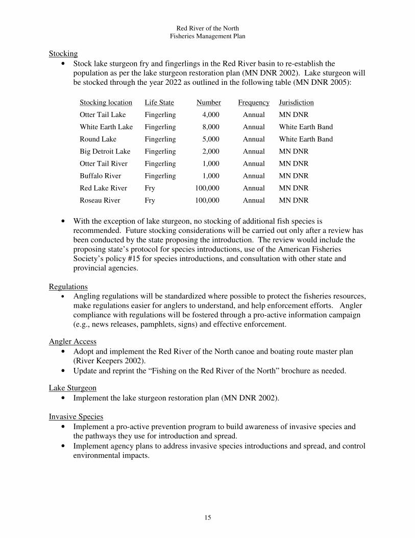
Stocking
• Stock lake sturgeon fry and fingerlings in the Red River basin to re-establish the
population as per the lake sturgeon restoration plan (MN DNR 2002). Lake sturgeon will
be stocked through the year 2022 as outlined in the following table (MN DNR 2005):
Stocking location Life State Number Frequency Jurisdiction
Otter Tail Lake Fingerling 4,000 Annual MN DNR
White Earth Lake Fingerling 8,000 Annual White Earth Band
Round Lake Fingerling 5,000 Annual White Earth Band
Big Detroit Lake Fingerling 2,000 Annual MN DNR
Otter Tail River Fingerling 1,000 Annual MN DNR
Buffalo River Fingerling 1,000 Annual MN DNR
Red Lake River Fry 100,000 Annual MN DNR
Roseau River Fry 100,000 Annual MN DNR
• With the exception of lake sturgeon, no stocking of additional fish species is
recommended. Future stocking considerations will be carried out only after a review has
been conducted by the state proposing the introduction. The review would include the
proposing state’s protocol for species introductions, use of the American Fisheries
Society’s policy #15 for species introductions, and consultation with other state and
provincial agencies.
Regulations
• Angling regulations will be standardized where possible to protect the fisheries resources,
make regulations easier for anglers to understand, and help enforcement efforts. Angler
compliance with regulations will be fostered through a pro-active information campaign
(e.g., news releases, pamphlets, signs) and effective enforcement.
Angler Access
• Adopt and implement the Red River of the North canoe and boating route master plan
(River Keepers 2002).
• Update and reprint the “Fishing on the Red River of the North” brochure as needed.
Lake Sturgeon
• Implement the lake sturgeon restoration plan (MN DNR 2002).
Invasive Species
• Implement a pro-active prevention program to build awareness of invasive species and
the pathways they use for introduction and spread.
• Implement agency plans to address invasive species introductions and spread, and control
environmental impacts.

Red River of the North
Fisheries Management Plan
16
V. Supplemental Information
Lake Sturgeon Restoration
Historical accounts suggest that lake sturgeon were abundant in the Red River basin until the late
1800's (Gough 1988-1992). Lake sturgeon populations in the Red River basin were decimated
by over exploitation, construction of dams, and declines in water quality. By the mid-1900's lake
sturgeon had effectively been extirpated from the Red River basin. Although there are
occasional, unconfirmed reports of lake sturgeon being caught in Red River, there is little chance
that this population can recover on its own.
The long-range goal for lake sturgeon restoration in the Red River basin is to establish a self-
sustaining population over the next 20 to 30 years (MN DNR 2002). Restoration activities will
include removal or modification of dams so that the maturing lake sturgeon population will be
able to access historic spawning areas and reproduce naturally, sturgeon stocking, protective
regulations and water quality improvement.
A major component of the lake sturgeon restoration plan is the reintroduction of lake sturgeon at
selected sites in the Red River basin using fry and fingerling stocking. Successful reintroduction
efforts may hinge upon stocking a young enough life stage so that imprinting to the receiving
water is maximized. Lake sturgeon grow slowly and mature at a late age, so stocking a
minimum of 20 lake sturgeon year classes is recommended.
Other sturgeon restoration activities include a public information/outreach program to inform the
public of our restoration plan, a no harvest regulation to remain in effect indefinitely on Red
River and its tributaries, and general water quality improvement and/or protection throughout the
Red River basin.
A complete description of Minnesota's plan for lake sturgeon restoration in the Red River basin
can be found in MN DNR (2002) and the current stocking regime can be found in MN DNR
(2005).
Dam Removal and Stream Restoration
The flow in Red River is directly affected by the presence of eight low head dams in the U.S.
The purpose of these dams is to store municipal water supplies, control river levels, or both.
Approximately l60 dams on tributary waters in Minnesota alone indirectly affect flow, with
numerous flood control projects presently proposed. Primary purposes of tributary dams include
floodwater retention, lake level maintenance, water supply, waterfowl production, or
hydropower.
Dams are often in disrepair and serve no existing discernable function. Many of the dams in the
Red River basin are barriers to fish migration and pose a drowning threat to the public. The MN
DNR, ND G&F and other project partners have worked to remove or modify dams to allow for
fish migration and address public safety concerns. Currently, five of the eight main stem dams
on U.S. segment of Red River have been modified: Fargo Midtown Dam (Fargo, ND) was
modified in 1999; Kidder Dam (Wahpeton, ND) was modified in 2000; Riverside Dam (Grand
Forks, ND) was modified in 2002; Fargo North Dam (Fargo, ND) was modified in 2002, and

Red River of the North
Fisheries Management Plan
17
Fargo South Dam (Fargo, ND) was modified in 2003. Plans to modify the three remaining dams
on the U.S. portion of mainstem Red River (Christine Dam near Christine, ND, Hickson Dam
near Hickson, ND, and Drayton Dam near Drayton, ND) are progressing.
Numerous dam removal/modification projects have been completed on Red River tributary
streams including, but not limited to: the Roseau City dam modification (Roseau River) and Old
Mill State Park dam removal (Middle River in 2001, the Buffalo River State Park dam (Buffalo
River) removal in 2002, the diversion dam fish by-pass project (Fergus Falls, MN Otter Tail
River) in 2002, the Lions Park Club Dam modification (Frazee MN; Otter Tail River) in 2003,
the East Grand Forks dam modification (Red Lake River) in 2003, the Crookston Dam
modification (Red Lake River, Crookston, MN) in 2005, the Heiberg dam modification (Wild
Rice River, Twin Valley, MN) in 2006, and the Argyle Dam removal (Middle River, Argyle,
MN) in 2007, and the Lake Breckenridge dam (Otter Tail River, Breckenridge, MN) in 2007.
These projects have resulted in the reconnection of hundreds of miles of stream habitat across the
Red River basin and the potential exists to reconnect hundreds more through continued efforts.
Water Quality
Major issues concerning Red River include flood control, drought, irrigation, sedimentation,
pollution (industrial, agricultural and municipal), recreation enhancement, municipal and private
water appropriations, and inter-basin water transfer. Several communities are established on the
banks of Red River; the three largest include the metropolitan areas of Fargo-Moorhead and
Grand Forks-East Grand Forks in the U.S. and Winnipeg in Manitoba.
The Red River watershed lies in an area of intense agricultural land use with extensive ditch and
transportation systems. Ditches are steeply sloped and many have unstable banks and lack
adequate, effective vegetative streamside buffers. The majority of the wetlands in the Red River
basin have been drained and stream channelization is common. Native vegetation has been
replaced with intensive row crop agriculture. This situation results in increased water
temperatures, decreased dissolved oxygen concentrations, and heavy sediment loads being
carried to Red River causing increased sedimentation and turbidity. Increased sedimentation
increases stress and mortality to aquatic organisms and directly effects spawning, nursery and
other important fish habitat by covering substrates, filling interstitial spaces, and reducing pool
depths.
Extreme river turbidity levels resulting from elevated sediment inputs indicates the need for
increased erosion control on all lands within the Red River watershed, especially those under
frequent tillage. Methods to improve water quality (e.g., reduce turbidity, PCBs and fecal
coliform levels) in Red River are: (l) restore functional, vegetative streamside buffers, (2)
improve soil conservation practices on watershed lands, (3) protect and restore wetlands
throughout the watershed, (4) stabilize stream banks and restore the natural functions of altered
stream channels, and (5) improve municipal and industrial point source discharges.
Fish Stocking
Fish stocking can be done for a variety of reasons including: to increase population size, to
maintain a population at the current level, to introduce a new species, to re-establish a species
that has been lost from an area, or as a reaction to social concerns.

Red River of the North
Fisheries Management Plan
18
There should be a clearly defined biological need for any stocking effort occurring in the Red
River basin and this should be described in a management plan for the particular species. In all
cases, fish stocking should not compromise existing fish populations or create problems for the
ecosystem. To minimize risk, stocking efforts should follow protocols established by the state or
province conducting the stocking. Any fish stocking into Red River should be done in
consultation with the other potentially affected states and province.
Invasive Species
Species that have been introduced, or moved, by humans into an area where they do not naturally
occur are called “exotic” or “non-native” species. Non-native species that cause ecological or
economic problems are termed “invasive species”. Invasive species can be introduced into
waters within the Red River basin through a variety of sources and pose a threat to the Red River
ecosystem and its recreational fisheries.
Preventing invasive species from being introduced and established in a system is the most
effective strategy against infestation. A pro-active prevention program should be implemented
across the Red River watershed to build awareness of invasive species and the pathways they use
for introduction and spread. State agencies have plans to address invasive species introductions
and spread (Schlueter 2007; MN DNR 2007) and general information and guidelines for
preventing invasive species can be found online at:
http://www.dnr.state.mn.us/invasives/index.html and at http://gf.nd.gov/fishing/ans.html.
Fisheries operations in the Red River basin should follow the guidelines outlined in MN DNR
(2007 draft).
The next step beyond prevention is early detection and rapid response. Early detection of an
invasive species and a quick, coordinated response offers the best chance to control the spread of
the invasive species and offers the best chance to minimize ecological and economic impacts.
For many aquatic species there is no known selective control, so the problems they cause
continue indefinitely. Management directed toward established invasive species focuses
primarily on controlling spread and negative impacts.
Recreational Access
Public access to Red River has been identified as an area in need of improvement to facilitate
outdoor recreational activities including, but not limited to: angling, canoeing, and boating. In
2001 and 2002, River Keepers, a Fargo-Moorhead based non-profit organization, inventoried
recreational use infrastructure (e.g., access sites, dams, road crossings) and developed a detailed
master plan (River Keepers 2002) to “…guide [infrastructure] development to maximize
sustainable use, encourage safety, and contribute to economic development.” Included in the
plan are detailed descriptions of existing and potential boat and canoe access sites, and a strategy
for implementing the overall plan. This plan should be used as the primary guide for access
development on Red River.

Red River of the North
Fisheries Management Plan
19
Literature Cited and Reference Documents
Aadland, L. P., T. M. Koel, W. G. Franzin, K.W. Stewart and P. Nelson. 2005. Changes in fish
assemblage structure of the Red River of the North. American Fisheries Society
Symposium 15:293-371, Annapolis, MD.
Aadland, L.P. and A. Kuitunen. 2006. Habitat suitability criteria for stream fishes and mussels
of Minnesota. Division of Ecological Services, Special Publication No. 162. Minnesota
Department of Natural Resources, St. Paul, MN
AFS. 1983. Stream obstruction removal guidelines. American Fisheries Society, Bethesda,
MD.
Brooks, L. and L.R. Schlueter. 1999. Angler use and sport fishing catch survey on the Red
River of the North, North Dakota: April 01 through May 05, 1999. North Dakota Game and
Fish Department, Fisheries Division.
Brooks, L. and L.R. Schlueter. 2002. Angler use and sport fishing catch survey on the Red
River of the North, North Dakota: March 15 through October 31, 2000. North Dakota Game
and Fish Department, Fisheries Division.
Brooks, L. and L.R. Schlueter. 2005. Angler use and sport fishing catch survey on the Red
River, North Dakota: April 1 through May 31, 2003. North Dakota Game and Fish
Department, Fisheries Division.
Bunn, S.E. and A.H. Arthington. 2002. Basic principles and ecological consequences of altered
flow regimes for aquatic biodiversity. Environmental Management 30: 492-507.
Clarke, R. McV., R.W. Boychuck, and D.A. Hodgins. 1980. Fishes of the Red River at
Winnipeg, Manitoba. Department of Fisheries and Oceans, Winnipeg, Manitoba.
Gough, B.M., editor. 1988-1992. The journal of Alexander Henry the Younger, 1799-1814,
Volume I. The Champlain Society, Toronto, Canada.
Eddy, S., R.C. Tasker and J.C. Underhill. 1972. Fishes of the Red River, Rainy River and Lake
of the Woods, Minnesota, with comments on the distribution of species in the Nelson River
Drainage. Bell Museum of Natural History, University of Minnesota. Occasional Paper No.
II.
Hegrenes, Scott. 1992. Age, growth and reproduction of channel catfish in the Red River of the
North. Master’s thesis, University of North Dakota, Grand Forks, ND.
Henry, M. 1996. Red River of the North population assessment, river miles 309-397.8.
Minnesota Department of Natural Resources, Division of Fish and Wildlife, Fergus Falls,
MN.

Red River of the North
Fisheries Management Plan
20
Henry, M. 2007. Red River of the North fisheries population assessment, summer 2005
combined reach report, reaches 1-4, river mile 0.0 to 400.4. Minnesota Department of
Natural Resources, Division of Fish and Wildlife, Bemidji, MN.
Huberty, G. 1996. Stream fish population assessment of the Red River, Reach two, from East
Grand Forks upstream to Moorhead; Polk, Norman and Clay counties, May 30-June 9, 1995.
Minnesota Department of Natural Resources, Division of Fish and Wildlife, Detroit Lakes,
MN.
International Joint Commission. 2000. Living with the Red. November 2000.
Koel, M.T. 1997. Distribution of fishes in the Red River of the North basin on Environmental
gradients. PhD dissertation, North Dakota State University, Fargo, ND.
Koel, T.M. and J.J. Peterka. 1998. Stream fishes of the Red River of the North basin, United
States: a comprehensive review. Canadian Field-Naturalist 11:631-646.
Lysack, W. 1986. The angling fishery of the lower Red River. Manitoba Natural Resources,
Fisheries, Manuscript report No. 86-16.
MacDonald, D. 1990. The channel catfish sport fishery of the lower Red River. Masters
Practicum. University of Manitoba, Winnipeg, Canada.
Martini, K.J. and J.D. Stewig. 2002. Red River of the North: fisheries population assessment
summer 2000 including the 1990-2000 assessment summaries. Minnesota Department of
Natural Resources. Study IV, Job 551, Completion Report. St. Paul, MN.
Menaks, M. 2000. Juvenile and larval fishes of the Red River of the North. M.S. thesis,
University of Minnesota, St. Paul, MN
MN DNR. 2007. Operation order #113; invasive species. Division of Ecological Services,
Minnesota Department of Natural Resources, St. Paul, MN.
MN DNR. 2007 (draft). Fisheries discipline guidelines for reducing the spread of non-target or
invasive species and pathogens. Division of Fish and Wildlife, Fisheries Management
Section and Division of Ecological Services, Minnesota Department of Natural Resources,
St. Paul, MN.
MN DNR. 2005. Revised MN DNR Red River basin sturgeon stocking regime. Minnesota
Department of Natural Resources, Bemidji, MN.
MN DNR. 2002. Restoration of extirpated lake sturgeon, Acipenser fulvescens, in the Red River
of the North Watershed. Minnesota Department of Natural Resources, Section of Fisheries,
Bemidji, MN.

Red River of the North
Fisheries Management Plan
21
MPCA. 2007 (draft). Fish kills on the Red River of the North; a report on the August 2003 and
July 2006 fish kills in the Fargo Moorhead area. Minnesota Pollution Control Agency,
Detroit Lakes, MN.
MPCA. 2008. Minnesota’s impaired waters list. Minnesota Pollution Control Agency,
www.pca.state.mn.us/water/tmdl/tmdl-303dlist.html.
Paakh,B., W. Goeken and D. Halvorson. State of the Red River of the North; assessment of the
2003/2004 water quality data for the Red River and its major Minnesota tributaries.
Minnesota Pollution Control Agency, Detroit Lakes Regional Office, Detroit Lakes, MN.
Rabeni, C.F. 1993. Warmwater Streams. pages 427-443 in C.C. Kohler and W.A. Hubert,
editors. Inland fisheries management in North America. American Fisheries Society,
Bethesda, MD.
Renard, P.A., S.R. Hanson and J.W. Enblom. 1986. Biological survey of the Red River of the
North, Special Publication No. 142. Division of Fish and Wildlife, Minnesota Department of
Natural Resouces, St. Paul, MN.
Resseguie, T. J. 2002. Distribution, relative abundance, and reproductive seasonality of larval
fish in the Red River. M.S. thesis, University of North Dakota, Grand Forks, ND.
River Keepers. 2002. Red River of the North canoe and boating route master plan.
Schlueter, L.R. 1998. Red River of the North: results of the April 1998 angler survey. North
Dakota Game and Fish Department, Fisheries Division report.
Stoner, J.D., Lorenz, D.L., Wiche, G.J., and Goldstein, R.M. 1993. Red River of the North
Basin, Minnesota, North Dakota, and South Dakota. American Water Resources
Association Monograph, Series No. 19 and Water Resources Bulletin, v.29, no.4, pp. 575-
615.
Schlueter, L.R. 2002 (draft). Investigations of the channel catfish population and their macro
habitats in the Red River of the North. North Dakota Fish and Game Department.
Schlueter, L. 2007. North Dakota aquatic nuisance species (ANS) management plan. North
Dakota Game and Fish Department, Devils Lake, ND.
Topp, D. 1996a. Red River of the North angler survey, 1994. Minnesota Department of Natural
Resources, Division of Fish and Wildlife, Baudette, MN
Topp, D. 1996b. Red River of the North population assessment, Reaches 3 and 4. Minnesota
Department of Natural Resources, Division of Fish and Wildlife, Baudette, MN.
Topp, D. 2001. Red River of the North creel survey: May 1-September 30, 2001. Minnesota
Department of Natural Resources, Baudette, MN.

Red River of the North
Fisheries Management Plan
22
Topp, D. 2003. Red River of the North creel survey: May 1 – September 30, 2001. Minnesota
Department of Natural Resources, Baudette, MN.
Topp, D., H. Drewes, M. Henry, G. Huberty and P. Jacobson. 1994. Assessment of the Red
River fishery, with special emphasis on channel catfish. Minnesota Department of Natural
Resources, Division of Fisheries and Wildlife, St. Paul, MN.
Wendel, J.L. 1999. Habitat use and movements of channel catfish in the Red River of the
North. Master’s thesis, University of North Dakota, Grand Forks, ND.

Red River of the North
Fisheries Management Plan
23
Red River of the North Fisheries Management Contacts
Henry Drewes
NW Region Fisheries Manager
2115 Birchmont Beach Road
Minnesota Dept. Nat. Res.
Bemidji, MN 56601
218-308-2623
Phil Talmage
Baudette Area Fisheries Manager
Minnesota Dept. Nat. Res.
204 Main Street E.
Baudette, MN 56623
218-634-2522
Ted Sledge
NW Region Assistant Fisheries Manager
2115 Birchmont Beach Road
Minnesota Dept. Nat. Res.
Bemidji, MN 56601
218-308-2623
Derek Kroeker
Manitoba Water Stewardship – Fisheries
Interlake Region
Box 6000 - Gimli R0C 1B0
204-642-6098.
Tom Groshens
Red River Fisheries Specialist
Minnesota Dept. Nat. Res.
6603 Bemidji Ave N.
Bemidji, MN 56601
218-308-2365
Lynn Schlueter
ANS Coord.
North Dakota Game and Fish Dept.
7928 45th Street NE
Devils Lake, ND 58301-8501
701-662-3617
Dave Friedl
Detroit Lakes Area Fisheries Manager
Minnesota Dept. Nat. Res.
14583 County Highway 19
Detroit Lakes, MN 56501
218-846-8341
Scott Gangl
Fisheries Management Section Leader
North Dakota Game and Fish Dept.
100 N. Bismarck Expressway
Bismarck, ND 58501-5095
701-328-6662
Arlin Schalekamp
Fergus Falls Area Fisheries Manager
Minnesota Dept. Nat. Res.
1509 First Ave N.
Fergus Falls, MN 56537
218-739-7576
Mark Ermer
Regional Fisheries Manager
South Dakota Dept. of Game Fish and Parks
603 E. 8th Ave.
Webster, SD 57274
605-345-3381

Red River of the North
Fisheries Management Plan
24

Red River of the North
Fisheries Management Plan
25
Red River of the North Management Plan
Signature Page