Embed Size (px)
Citation preview

University of Wollongong University of Wollongong
Research Online Research Online
Faculty of Science, Medicine and Health - Papers: part A Faculty of Science, Medicine and Health
1-1-2016
Recycling of Pleistocene valley fills dominates 135 ka of sediment flux, Recycling of Pleistocene valley fills dominates 135 ka of sediment flux,
upper Indus River upper Indus River
Henry Munack University of Potsdam
J H. Blöthe University of Bonn
Reka H. Fulop University of Wollongong, [email protected]
Alexandru Tiberiu Codilean University of Wollongong, [email protected]
David Fink University of Wollongong
See next page for additional authors
Follow this and additional works at: https://ro.uow.edu.au/smhpapers
Part of the Medicine and Health Sciences Commons, and the Social and Behavioral Sciences
Commons
Recommended Citation Recommended Citation Munack, Henry; Blöthe, J H.; Fulop, Reka H.; Codilean, Alexandru Tiberiu; Fink, David; and Korup, Oliver, "Recycling of Pleistocene valley fills dominates 135 ka of sediment flux, upper Indus River" (2016). Faculty of Science, Medicine and Health - Papers: part A. 4042. https://ro.uow.edu.au/smhpapers/4042
Research Online is the open access institutional repository for the University of Wollongong. For further information contact the UOW Library: [email protected]

Recycling of Pleistocene valley fills dominates 135 ka of sediment flux, upper Recycling of Pleistocene valley fills dominates 135 ka of sediment flux, upper Indus River Indus River
Abstract Abstract Rivers draining the semiarid Transhimalayan Ranges at the western Tibetan Plateau margin underwent alternating phases of massive valley infill and incision in Pleistocene times. The effects of these cut-and-fill cycles on millennial sediment fluxes have remained largely elusive. We investigate the timing and geomorphic consequences of headward incision of the Zanskar River, a tributary to the Indus, which taps the >250-m thick More Plains valley fill that currently plugs the endorheic high-altitude basins of Tso Kar and Tso Moriri. In situ 10Be exposure dating and topographic analyses show that a phase of valley infill gave way to net dissection and the NW Himalaya's first directly dated stream capture in late Marine Isotope Stage (MIS) 6, ∼135 ka ago. Headwaters of the Indus are currently capturing headwaters of the Sutlej, and rivers have eroded >14.7 km3 of sediment from the Zanskar headwaters since, mobilising an equivalent of ∼8% of the Indus' contemporary sediment storage volume from only 0.3% of its catchment area. The resulting specific sediment yields are among the rarely available rates averaged over the 105-yr timescale, and surpass 10Be-derived denudation rates from neighbouring catchments three- to tenfold. We conclude that recycling of Pleistocene valley fills has fed Transhimalayan headwaters with more sediment than liberated by catchment denudation, at least since the last glacial cycle began. This protracted release of sediment from thick Pleistocene valley fills might bias estimates of current sediment loads and long-term catchment denudation.
Disciplines Disciplines Medicine and Health Sciences | Social and Behavioral Sciences
Publication Details Publication Details Munack, H., Blöthe, J. H., Fulop, R. H., Codilean, A. T., Fink, D. & Korup, O. (2016). Recycling of Pleistocene valley fills dominates 135 ka of sediment flux, upper Indus River. Quaternary Science Reviews: the international multidisciplinary research and review journal, 149 122-134.
Authors Authors Henry Munack, J H. Blöthe, Reka H. Fulop, Alexandru Tiberiu Codilean, David Fink, and Oliver Korup
This journal article is available at Research Online: https://ro.uow.edu.au/smhpapers/4042

Recycling of Pleistocene valley fills dominates 135 ka of sediment
flux, upper Indus River
Munack, H.1*, Blöthe, J.H.2, Fülöp, R.H.3,4, Codilean, A.T.3, Fink, D.4, Korup, O.1
1 Institute of Earth and Environmental Science, University of Potsdam, 14476 Potsdam, Germany
2 Department of Geography, University of Bonn, 53115 Bonn, Germany
3 School of Earth and Environmental Science, University of Wollongong, Wollongong NSW 2522, Australia
4 Institute for Environmental Research (IER), ANSTO Australian Nuclear Science and Technology Organisation, Lucas Heights
NSW 2234 Australia
* Corresponding author: [email protected]‐potsdam.de
Abstract
Rivers draining the semiarid Transhimalayan Ranges at the western Tibetan Plateau margin
underwent alternating phases of massive valley infill and incision in Pleistocene times. The
effects of these cut‐and‐fill cycles on millennial sediment fluxes have remained largely
elusive. We investigate the timing and geomorphic consequences of headward incision of
the Zanskar River, a tributary to the Indus, which taps the >250‐m thick More Plains valley fill
that currently plugs the endorheic high‐altitude basins of Tso Kar and Tso Moriri. In situ 10Be
exposure dating and topographic analyses show that a phase of valley infill gave way to net
dissection and the NW Himalaya’s first directly dated stream capture in late Marine Isotope
Stage (MIS) 6, ~135 ka ago. Headwaters of the Indus are currently capturing headwaters of
the Sutlej, and rivers have eroded >14.7 km3 of sediment from the Zanskar headwaters
since, mobilising an equivalent of ~8% of the Indus’ contemporary sediment storage volume
from only 0.3% of its catchment area. The resulting specific sediment yields are among the
rarely available rates averaged over the 105‐yr timescale, and surpass 10Be‐derived

denudation rates from neighbouring catchments three‐ to tenfold. We conclude that
recycling of Pleistocene valley fills has fed Transhimalayan headwaters with more sediment
than liberated by catchment denudation, at least since the last glacial cycle began. This
protracted release of sediment from thick Pleistocene valley fills might bias estimates of
current sediment loads and long‐term catchment denudation.
Keywords
Transhimalaya; Zanskar; Indus; valley fill; drainage capture; in‐situ cosmogenic 10Be
Highlights
We directly date one of Himalaya’s youngest drainage captures at the end of MIS 6
Headwaters of the Indus are currently capturing headwaters of the Sutlej
105‐yr fluvial sediment flux of up to ~270 t km–2 yr–1 from Pleistocene valley fills
Up to 8% of Indus’ sediment storage volume eroded from 0.3% of catchment area
Recycled sediment yields are up to ten times higher than catchment denudation
1. Introduction
The Indus is amongst Earth’s largest river systems in terms of discharge, catchment area, and
sediment load (Milliman and Meade, 1983; Clift, 2002; Milliman and Farnsworth, 2011). It
drains large parts of the western Tibetan Plateau margin, Transhimalayan ranges,
Karakoram, and western Himalayan mountain ranges (Inam et al., 2008), and may be as old
as the early uplift of the Tibetan Plateau (Rowley and Currie, 2006; Decelles et al., 2007; C.

Wang et al., 2008). Sedimentary analyses of the submarine Indus fan indicate that the river
has not changed very much since ~45 Ma when it was already flowing westward through the
Indus‐Tsangpo Suture Zone (Clift et al. 2001; Clift, 2002) where the Eurasian and Indian
continental plates meet. Others proposed that the Indus established its course much later
(Sinclair and Jaffey, 2001). During its lifetime the Indus has tapped various sources of
sediments, partly by headward incision into the Tibetan Plateau interior, partly by exploiting
tectonic structures (Clift and Blusztajn, 2005; Garzanti et al., 2005).
Various mechanisms influence how rivers incise into the Tibetan Plateau over millennial
to geological timescales (Bendick and Bilham, 2001; Lavé and Avouac, 2001; Sobel, 2003;
Ouimet et al., 2007; Korup et al., 2010). Aridity can slow down discharge‐driven fluvial
incision, preserve plateau remnants, and create long‐lived internally drained river systems
(Sobel, 2003). Conversely, headward river incision aids plateau dissection through drainage
capture. Yet systematic analysis and dating of drainage capture events are rare, especially
along the western margin of the Tibetan Plateau and the Transhimalayan upper Indus basin.
There, sedimentary basin‐fills up to several hundred metres thick smother an alpine
landscape, offering a stark contrast to stretches of deeply dissected bedrock gorges. We
hypothesize that paired high‐level terraces in the upper Zanskar River, a major tributary
(~15,000 km2) of the Indus, mark the change from net valley infilling to dissection. Dating
those terraces should allow comparing the resulting long‐term fluvial sediment yields with
catchment‐wide denudation rates based on 10Be concentrations in river sands accumulated
over tens of millennia. Our objective is thus to constrain when and how much of the large
valley fills in upper Zanskar headwaters were eroded, and to clarify the role of this erosion
for sediment‐flux estimates in this major Transhimalayan river.
2. Study area
The Indus River flows through deep bedrock gorges and broad braidplains upstream of the
Nanga Parbat syntaxis, an area of rapid exhumation and bedrock incision (Burbank et al.,
1996; Zeitler et al., 2001; Garzanti et al., 2005). Denudation rates along the Indus drop from
>1000 mm ka‐1 near the syntaxis (Burbank et al., 1996) to ~10 mm ka‐1 at the western
Tibetan Plateau margin (Munack et al., 2014). Denudation rates estimated from cosmogenic
10Be inventories are low despite the steep alpine topography (Dortch et al., 2011; Dietsch et
al., 2014; Munack et al., 2014), so that the Transhimalayan ranges of Ladakh and Zanskar
host some of the oldest glacial landforms in the Himalaya‐Tibet orogen (Owen et al., 2006;
Hedrick et al., 2011). Massive staircases of river‐derived fill terraces (Fort et al., 1989; Clift
and Giosan, 2014) located up to 400 m above present river levels, together with stacks of
lake sediments and local landslide and fan deposits (Hewitt, 2002; Phartiyal et al., 2005;
2013), testify to major alternating cut‐and‐fill cycles in the upper Indus catchment (Blöthe et
al., 2014). Some of these prominent sediment bodies are between 100 and 530 ka old (Owen
et al., 2006; Blöthe et al., 2014; Scherler et al., 2014), and demonstrate the longevity of
valley fills in the rain shadow of the Higher Himalayas. How these large valley fills affect
sediment flux and drainage patterns along the western Tibetan Plateau margin (Blöthe and
Korup, 2013; Clift and Giosan, 2014) remains to be resolved in more detail, though.
To elucidate the response of major rivers to major cut‐and‐fill cycles we investigate a
large valley fill of the Rupshu Plateau (Fig. 1) where the soil mantled, gently sloping, and
slowly denuding western Tibetan Plateau margin grades into the steep and rugged
Transhimalayan ranges (Munack et al., 2014). We focus on the dissected and >250‐m thick
valley fill of the More Plains, which is part of an extensive aggradation surface in the
headwaters of the Zanskar River (Fig. 1). Terraced remnants of this valley fill (Fig. 2) occur
throughout the Sumka (298 km2) and Tozai catchments (475 km2, Fig. 1) that line the
topographically inconspicuous drainage divide between the Indus and the Sutlej Rivers (Fig.
3) that drain the mountain belt to the northwest and southeast, respectively. At about 4765
m asl, the gently sloping surface of the More Plains features abandoned river channels
pointing north into the Zara River.
The geology of our study area (Fig. 3) is dominated by sedimentary shales, sandstones,
and siltstones of the pre‐collisional Kurgiakh Formation (Garzanti et al., 1986; Steck, 2003,
Fig. 3, #28), marls and limestones of the Lilang group (Fig. 3, #22), and intrusive crustal
granites (Fig. 3, #26) and local gabbros (Fuchs and Linner, 1996; Steck, 2003; de Sigoyer et
al., 2004), forming much of the Tso Moriri and Tso Kar lake basins. Siltstones of the
Lamayuru Formation (Fig. 3, #14) and Lamayuru Flysch of the Neotethyan slope underlie the
southern Tso Moriri basin (Frank et al., 1977; Steck, 2003). Flowing along the southern
slopes of the pre‐collisional granodioritic Ladakh Batholith and cutting through some
ophiolitic mélange (Steck, 2003, Fig. 3, #9), the Indus River bounds the study area in the
north. Dolomitic limestones of the Kioto Formation dominate the western parts of the Tozai
catchment (Hayden, 1904; Steck, 2003; Fig. 3, #20).
3. Methods
To assess late Quaternary valley filling and dissection in the upper Zanskar near the More
Plains, we combine in‐situ produced cosmogenic 10Be analyses in river sediment,
amalgamated surface and depth‐profile samples, with topographic analyses and field
observations.
3.1. Cosmogenic 10Be analyses
We collected sediment samples from five perennial rivers draining quartz‐bearing lithologies
(catchment areas ranging between 4 and 270 km2) to derive catchment‐wide denudation

rates from concentrations of cosmogenic 10Be in these samples (Figs. 1, 3, Table 1). We also
collected two amalgamated grab samples for cosmogenic 10Be exposure dating of terrace
treads flanking the deeply incised Sumka River (PTOP and DP_Surf; Figs. 1, 2, 4, Table 2),
each consisting of 35 well‐rounded quartz‐bearing pebbles (b‐axes of 2‐6 cm). At the location
of DP_Surf, we further collected samples from a gravel pit from depths of 20 to 160 cm at
20‐cm intervals (DP_020 to DP_160; Fig. 4; Table 2). For both the PTOP and DP_Surf
sampling locations, which are ~3 km apart and at similar elevations, we recorded the
topographic shielding and coordinates with a handheld GPS receiver with <10 m horizontal,
and <20 m vertical, accuracy.
We isolated the 125‐500 µm‐sized quartz‐grain fraction from the samples and the
crushed and sieved pebble aggregate (surfaces and depth profile) samples following
standard procedures for in‐situ cosmogenic 10Be analysis (Kohl and Nishiizumi, 1992). We
extracted beryllium using ion chromatography at the Australian Nuclear Science and
Technology Organisation (ANSTO) following procedures described in Child et al. (2000). All
samples were spiked with a 10Be–free solution of ~370 µg 9Be prepared from a beryl crystal
solution at 1080 (± 0.7%) ppm. Full procedural chemistry blanks were prepared from the
same beryl and gave a final mean 10Be/9Be ratio of 5.15 ± 1.34 x 10‐15 (n=4, mean of two
procedural blanks). The 10Be/9Be ratios were measured at the ANSTO ANTARES accelerator
(Fink and Smith, 2007) and were normalised to the 2007 KNSTD standard KN‐5‐2 with a
nominal 10Be/9Be ratio of 8,558 × 10‐15 (Nishiizumi et al., 2007). Blank corrected 10Be/9Be
ratios ranged between 16.8 and 229.4 x 10‐13 with analytical errors ranging from 1 to 2% (See
Tables 1 and 2). Errors for the final 10Be concentrations (atoms/g) were calculated by
summing in quadrature the statistical error for the AMS measurement, 2% for
reproducibility, and 1% for uncertainty in the Be spike concentration.

We calculate terrace surface ages from the depth‐profile samples collected at DP‐Surf
with a Monte Carlo simulation based on the cosmogenic nuclide ingrowth equation of
(Braucher et al., 2011):
, , ⁄
1 ⁄
1 ⁄
1
(1)
where is the 10Be concentration [at. g‐1], is depth below surface [cm], t is the exposure
time [yr], is the surface denudation rate [g cm‐2 yr‐1], P is the total surface production rate
of 10Be [at g‐1 yr‐1], is the radioactive decay constant ( = 4.998 ± 0.043 × 10‐7), n, m1, m2
are the relative contributions of neutrons, slow muons, and fast muons, respectively to the
total 10Be production (n = 98.87%, m1 = 0.27%, m2 = 0.86%; Braucher et al., 2011), and Λn,
Λm1, Λm2 are their respective attenuation lengths (Λn = 160 g cm‐2, Λm1 = 1500 g cm‐2, Λm2
= 4320 g cm‐2; Braucher et al., 2011). Note that in Eq. (1) reflects a surface denudation rate
expressed in units of length per time [cm yr‐1] multiplied by density [g cm‐3]. We calculate
the total 10Be surface production rate (P) using the time‐dependent altitude and latitude
scaling scheme of Stone (2000), a 10Be sea‐level high‐latitude (SLHL) spallation production
rate of 3.94 ± 0.20 at g‐1 yr‐1 (Heyman, 2014), and the muogenic production rates reported in
(Braucher et al., 2011). Our 10Be SLHL spallogenic production rate is statistically identical to
those reported in (Borchers et al., 2016). We use the updated 10Be half‐life of 1.387 ± 0.012
Ma (Chmeleff et al., 2010; Korschinek et al., 2010) in all our calculations.
The imperceptibly sloping surfaces (~0.25°) from where we collected DP_Surf and PTOP
have distinct frost polygons, and a thin veneer of aeolian silt, such that we assumed
negligible erosion of the abandoned More Plains surface. Field observations and satellite

images confirm that the DP_Surf and PTOP sampling sites did not experience any colluvial
deposition. Hence, we run our exposure model with a zero denudation rate. We allow
density to vary as a free parameter between 1.9 to 2.3 g cm‐3, and obtain a best‐fit terrace
surface age by minimising (Bevington and Robinson, 2003):
∑, , ,
, (2)
where is the calculated 10Be concentration [at. g‐1] using Eq. (1), and and are random
samples from the normally distributed concentration measurements and their standard
deviation. We estimate the 68% confidence intervals of our best‐fit terrace surface age as
1 (Bevington and Robinson, 2003). Our calculations neglect possible shielding effects
on 10Be production rates by ice and snow. We believe that this simplification is justified,
given that local glacial chronologies – particularly since MIS 5e – show only minor glacier
advances that could have influenced 10Be concentrations (Taylor and Mitchell, 2000; Owen
et al., 2006; Hedrick et al., 2011); the high‐altitude desert of Zanskar also rarely favours thick
snow cover (Burbank and Fort, 1985).
We derived basin‐wide production rates from a 30m SRTM DEM (available at
http://earthexplorer.usgs.gov) of the study area using the same 10Be SLHL production rates
and scaling scheme as above. We correct for topographic shielding following Codilean (2006)
and use Eq. (1) to calculate catchment‐wide denudation rates.
3.2. Eroded sediment volume calculations
To estimate the volume of sediment eroded from the valley fills in the upper Zanskar, we
used two different methods. First, we emplaced a hypothetical dam on the 30‐m SRTM DEM
of the study area and calculated the backfill volume using standard GIS fill‐routines (method
#1), resulting in a sediment wedge with a horizontal surface (Fig. 1, 5). Second, we used the

elevation of terrace remnants that flank the modern rivers to reconstruct the former valley
floor of the Sumka and Tozai valleys (method #2). Based on our 30‐m DEM we measured 2.5‐
km‐wide sections spaced 500 m apart and normal to the mean former drainage direction of
the valleys, which we estimated from satellite images (Fig. 5). For each cross‐section, we
extracted the raster cell values from the SRTM DEM with local slopes <15°, which we took as
an upper threshold for terrace‐surface slopes. We used a nonlinear median quantile
regression (Koenker, 2005) to reconstruct the concave‐upward former valley bottom by
connecting the trends of the terrace treads:
∗ ∗ (3)
where is the elevation of terraces [m], is distance upstream of an arbitrary starting
point [m], [m–2] and [1] are estimated coefficients and [m] is the intercept. We used
Eq. 3 to estimate the former elevation for each cell upstream of the dissected fill, and
subtracted the SRTM DEM to calculate the eroded volume and resulting average sediment
yields within 2 σ uncertainty.
4. Results
Several km‐scale risers of the More Plains along the Sumka River near the village of Pang
offer >250‐m thick outcrops dotted by badland‐like sedimentary pillars (Fig. 2C). North‐
facing risers are degraded by permafrost flow failures and slumps (Fig. 2D). The exposed
sediments are surprisingly homogenous in terms of bedding, composition, clast size, and
shape. Sub‐rounded, very coarse pebbles in a yellow ochre, silt‐cemented matrix dominate
this valley fill (Fig. 2 E–H). Beds in the eastern part of the section are between <0.5 m to >5
m thick, show fluvial imbrication, dip between 1° and 3° towards the north to northeast, and
alternate from limestone‐ to granite‐dominated. A 3‐m deep and 10‐m long trench that we

dug into the western More Plains surface (star on Fig. 5) was devoid of granitic clasts,
consistent with the non‐granitic lithologies of the Tozai catchment (Steck, 2003), as opposed
to the upper Sumka catchment, which features intrusive rocks (Fig. 3).
A Monte Carlo simulation yields a best‐fit exposure age for the More Plains surface
(DP_SURF in Figs. 1 and 2) of 135 ka (Fig. 4). The 1‐σ confidence limits calculated as 1
(Bevington and Robinson, 2003) are 122.5 ka and 143 ka. The amalgamated surface grab
sample at PTOP (Figs. 1 and 2) has a 10Be concentration equal to that of DP_SURF within 1σ
uncertainty (Fig. 4). Considering the identical elevation, surface slope (Fig. 2), material
properties, and bedding of the sedimentary units underlying the DP_SURF and PTOP
samples, we infer similar sources, pathways, and transport times, and hence similar
exposure histories with comparable amounts of inherited 10Be. Thus, we assign the same
surface age for PTOP as the one obtained for DP_SURF, proposing 135 . ka as the
earliest time when net aggradation of the More Plains switched to net incision.
Depending on the approach to reconstruct the former surface of the More Plains
upstream of Pang (Fig. 1), the volumes of sediment that we estimate were lost to fluvial
erosion vary by nearly a factor of three. For the Sumka valley, the removed sediment volume
is at least 1.23 ± 0.2 km3, if assuming a formerly flat valley floor (method #1, Fig. 5A). In
contrast, the concave‐up sediment wedge estimated from a polynomial fit to the terrace
surfaces (method #2) has a volume of 3.59 .. km3 (Fig. 5A). For the Tozai valley, the
volumes obtained for both methods are 3.97 ± 0.7 and 11.1 .. km3, respectively (Fig. 5B).
Keeping in mind that method #1 consistently underpredicts valley‐fill volumes because it
ignores the slope of the former valley floor, we estimate that rivers removed ~14.7 km3 of
sediment since they began incising into the More Plains. The corresponding average
sediment yields are 170 t km−2 yr−1 for the Sumka valley (Fig. 1, red polygon), and
329 t km−2 yr−1 for the Tozai valley (Fig. 1, yellow polygon); the average yield for both
valleys is 267 t km−2 yr−1 (Table 3).
The 10Be concentrations of the river‐sand samples (Table 1, Fig. 1) translate to
catchment‐averaged denudation rates between 13.1 ± 0.5 and 26.4 ± 0.7 mm ka−1 (Table 1).
The associated averaging timescales (von Blanckenburg, 2005) are 45.9 to 22.7 ka (Table 1),
and thus postdate major glacial periods judging from the regional chronology of Pleistocene
glaciations (Burbank and Fort, 1985; Taylor and Mitchell, 2000; Owen et al., 2006; Hedrick et
al., 2011). These denudation rates correspond to average sediment yields of 36‐50 t km−2
yr−1 (Table 1), assuming that sediment storage on hillslopes is negligible.
5. Discussion
5.1. Valley infill, river capture, and dissection
Preserved channel patterns on the More Plains section consistently indicate that the Sumka
and Tozai catchments formerly drained northward across the More Plains into the Zara River
(Fig. 3), possibly into the Tso Kar catchment via what is today a major wind gap (Figs. 5, 7).
Elevation profiles across the Sumka and Tozai valleys reveal a former aggradation surface
graded to the N‐NE dipping More Plains surface (Figs. 5, 7B; blue dots in profiles #2 and #3).
Remnants of this formerly more expansive, but now dissected, valley floor rest >200 m
above the lower Tozai and Sumka rivers (Fig. 2E–H). Mostly very coarse sub‐rounded gravels
in this fill point at fluvial and debris‐flow sedimentation that operated over short distances
and rapidly infilled a valley network. Although the Tozai and Sumka catchments share
indistinct transfluence passes with the neighbouring Phirtse drainage in the Sutlej
headwaters (Fig. 3; Thelakung La and southward), most of the valley fill would have been
locally derived. We infer that the Tozai River tapped this formerly northward draining river
system by incising into the More Plains valley fill shortly after 135 ka, essentially cutting

short the 80‐km long horseshoe‐shaped valley of the Zara River (Profile ‘p‐p2’ in Figs. 5, 7B‐C,
respectively). To our knowledge, this is the first directly dated river capture in the NW
Himalayas near the drainage divide between the Indus and Sutlej Rivers.
The full extent of the former More Plains valley fill is vague, but would have reached the
Sumka‐Tozai confluence at least. A much larger valley fill extending to the present Zara‐Tozai
confluence is also conceivable (upstream of red dots in profile #3, Fig. 7B). If the Tozai valley
drained north across the More Plains prior to the MIS 6‐5e transition (‘horseshoe’ in Fig. 5),
headward incision commencing here at ~135 ka would have forced the river to follow a
steeper gradient towards the west (‘shortcut’ in Fig. 5). In any case, undercutting both down‐
and upstream isolated the More Plains between the Sumka (‘p’ in profile #8, Fig. 7) and the
present upper Zara (‘p1’ profile #1, Fig. 7) rivers; the latter is largely graded to the modern
confluence with the Tozai River, whereas the former valley fill of the More Plains is not.
Hillslopes in the area around the Tozai‐Sumka confluence (Fig. 6A) might be remains of
the pre‐capture bedrock topography. They appear to be adjusted to the More Plains surface,
and rivers could have plausibly migrated headward here. Such a retreat towards the Pangyo
basin east of the Tozai headwaters (Fig. 3), and along the lowest point of the 5090‐m
transfluence pass, is a possible scenario for future drainage changes. The longitudinal
profiles of the Zanskar headwaters are much steeper than those of the Sutlej (Fig. 7A), and
likely incising faster. Hence the Indus‐Sutlej drainage is bound to migrate eastward here with
the Indus headwaters gaining ground.
5.2. Catchment denudation and recycling of Pleistocene sediments
The 10Be‐derived denudation rates of catchments fringing the endorheic lakes of Tso Kar and
Tso Moriri (Fig. 1, Table 1) fit the picture of very slow landscape lowering in the upper Indus
basin (Dortch et al., 2011; Munack et al., 2014). Denudation rates along the western shore of

Tso Moriri (19‐26 mm ka‐1, Fig. 1, Table 1) are statistically indistinguishable from those in the
nearby Ladakh Batholith, but higher than in the Numah catchment (Fig. 1), which we
expected to denude faster following river capture ~135 ka ago. Rock type might play a
subordinate role, as the faster denuding catchments drain more competent rocks. The low
denudation rates in Numah catchment might reflect incomplete headward incision of the
Sumka River into its tributaries, whereas the higher rates in the Tsomo, Korzog, and Yan
catchments might respond to active normal faulting along the western shoulder of the Tso
Moriri half‐graben (Hintersberger et al., 2010).
In any case, the net sediment flux from the recycled More Plain valley fill exceeds
headwater denudation inferred from 10Be by a factor of three to ten. This reworking distorts
the long‐term sediment flux in the upper Zanskar River over the past two glacial‐interglacial
cycles. Differing timescales are not an issue here, as the lower 10Be‐derived denudation rates
concern roughly a third of the time since incision into the More Plains began (Table 1). If
anything, we would expect higher rates for the shorter integration time instead, given less
time to accommodate phases of negligible geomorphic activity.
5.3. Regional context and relevance
We provide an estimate of sediment yields averaged over >100 ka, building a rare link
between geomorphic and geological timescales for the NW Himalayas. Our estimate of 14.7
km3 of eroded valley fills in the upper Zanskar suggests that an equivalent of as much as 8%
of the contemporary sediment volume stored in the Indus catchment (Blöthe and Korup,
2013) may have come from as little as 0.3% of its area. Clift and Giosan (2014) estimated
that 7 to 22 km3 of valley fills were lost from the entire Zanskar catchment since 10 ka. The
removal of stored sediments would have fed average yields of 90‐280 t km–2 yr–1 over that
shorter period, but strikingly similar to our estimated yields from the Zanskar headwaters

since 135 ka. Although obtained over different timescales, both estimates underline the
relevance of (Trans‐)Himalayan valley fills, and especially those in headwater settings, for
understanding major catchment dynamics (Table 3).
Our findings from the More Plains support previous work in the region on multiple 104‐yr
cycles of infilling of alpine bedrock landscapes, and subsequent removal of this sediment,
leaving former valley floors stranded as terraces several hundred metres high. At the
Zanskar‐Indus confluence, Blöthe et al. (2014) identified at least two postglacial phases of
valley infilling before ~200 ka, and 50‐20 ka, preserved in >150‐m and 30‐ to 40‐m high
terraces, respectively (Fig. 8). Near the More Plains the geomorphic legacy of these major
sedimentary cycles is particularly striking, smothering a substantial fraction of the alpine
relief below hundreds of metres of debris. Few comparably extensive former valley floors
line the rivers in Ladakh and Zanskar. The More Plains are much younger, for example, than
a prominent 233‐ka (MIS 7) terrace on the Indus near Nimu (Fig. 8D #4). Another large
terrace at Agham in the Shyok River similarly records a turn from net aggradation to net
incision at ~124 ka (MIS 6‐5e; Fig. 8C #2; also recalculated). Yet only the paired terraces of
the More Plains allow estimating the sediment volumes lost to fluvial erosion with
confidence. Most of the former valley floors in the region were abandoned at the transition
from glacials to interglacials, although major valleys such as the Shyok‐Nubra and the
Zanskar also aggraded during interglacials. River capture and subsequent sediment release
from the More Plains section, i.e. the present Sumka (and Tozai) valleys, commenced during
late MIS 6, but pinpointing climatic drivers remains problematic. Hedrick et al. (2011)
proposed five glacial advances for the Korzog catchment, based on 10Be exposure dates of
moraine boulders (Figs. 1, 8). The oldest and youngest of these advances were within only
~15 km and ~1 km from modern glacier snouts at 310 ± 4.1 ka and 3.6 ± 1.1 ka, respectively

(Fig. 8E, ‘K’). Other advances occurred around 80 ka (Fig. 8E, ‘Z’; Taylor and Mitchell, 2000)
and ~24 ka (Hedrick et al., 2011). Deposition on the More Plains ceased around ~135 ka at
the latest. Lacking evidence of major glaciations in the surrounding Zanskar ranges between
~250 ka and ~110 ka (Fig. 8E) so far rules out major glacial sediment sources for the More
Plains, such that the search for alternative sources remains open.
6. Conclusions
Pleistocene cycles of widespread aggradation and dissection shaped the mountain valleys of
the western Tibetan plateau and the Transhimalayan Ranges. We report the first directly
dated river capture in the headwaters of the Zanskar River close to the drainage divide of the
Indus and the Sutlej, and propose an onset of river incision at the MIS 6‐5e transition. This
particular capture event might be part of a gradual eastward extension of the Indus at the
expense of the Sutlej. Rivers lowered valley floors by >250 m, bypassed some 80 km of
drainage route, and released up to 8% of the sediment storage of the Indus River from <0.3%
of its area. The resulting average net sediment yields from these eroding basin fill deposits
offer rare estimates on the 105‐yr scale, and exceed yields derived from 10Be‐derived basin‐
wide denudation. We infer that reworking of stored sediment in the semi‐arid
Transhimalayan Ranges may distort average sediment flux estimates over periods spanning
two glacial‐interglacial cycles, and thus complicate straightforward comparison between
processes of erosion, sediment transfer, and deposition in this area dominated by low rates
of long‐term denudation.
Acknowledgements
The Potsdam Graduate School (PoGS), the German Research Foundation (KO3937/1,2), and
the Potsdam Research Cluster for Georisk Analysis, Environmental Change and Sustainability

(PROGRESS) funded this research. We are grateful to Peter Clift and an anonymous reviewer
for thorough and constructive reviews. We thank Amelie Stolle, Martin Struck, Piero
Catarraso, and Tinles Nubuu for fieldwork assistance (photos in Figs. 2G, H courtesy of
Amelie Stolle), and Eduardo Garzanti for scientific advice. We used the R software
environment (cran.r‐project.org), QGIS Geographic Information System (qgis.org), and SAGA‐
GIS (saga‐gis.org) for processing data. Xiaoping Yang kindly handled the manuscript.
References
Balco, G., Stone, J.O., Lifton, N.A., Dunai, T.J., 2008. A complete and easily accessible means of calculating surface exposure ages or erosion rates from 10Be and 26Al measurements. Quaternary Geochronology 3, 174–195.
Bendick, R., Bilham, R., 2001. How perfect is the Himalayan arc? Geology 29, 791. Berger, A., Loutre, M.F., 1991. Insolation values for the climate of the last 10 million years.
Quaternary Science Reviews 10, 297–317. Bevington, P.R., Robinson, D.K., 2003. Data reduction and error analysis for the physical
sciences, 3rd ed. McGraw‐Hill Higher Education, New York. Blöthe, J.H., Korup, O., 2013. Millennial lag times in the Himalayan sediment routing system.
Earth and Planetary Science Letters 382, 38–46. Blöthe, J.H., Munack, H., Korup, O., Fülling, A., Garzanti, E., Resentini, A., Kubik, P.W., 2014.
Late Quaternary valley infill and dissection in the Indus River, western Tibetan Plateau margin. Quaternary Science Reviews 94, 102–119.
Borchers, B., Marrero, S., Balco, G., Caffee, M.W., Goehring, B., Lifton, N., Nishiizumi, K., Phillips, F., Schaefer, J., Stone, J., 2016. Geological calibration of spallation production rates in the CRONUS‐Earth project. Quaternary Geochronology 31, 188–198.
Braucher, R., Merchel, S., Borgomano, J., Bourlés, D.L., 2011. Earth and Planetary Science Letters. Earth and Planetary Science Letters 309, 1–9.
Burbank, D.W., Fort, M.B., 1985. Bedrock control on glacial limits: Examples from the Ladakh and Zanskar ranges, north‐western Himalaya, India. Journal of Glaciology 31, 143–149.
Burbank, D.W., Leland, J., Fielding, E., Anderson, R.S., Brozovic, N., Reid, M., Duncan, C., 1996. Bedrock incision, rock uplift and threshold hillslopes in the northwestern Himalayas. Nature 379, 505–510.
Cheng, H., Zhang, P.Z., Spötl, C., Edwards, R.L., Cai, Y.J., Zhang, D.Z., Sang, W.C., Tan, M., An, Z.S., 2012. The climatic cyclicity in semiarid‐arid central Asia over the past 500,000 years. Geophys. Res. Lett. 39, L01705.
Child, D., Elliott, G., Mifsud, C., Smith, A.M., Fink, D., 2000. Sample processing for earth science studies at ANTARES. Nuclear Instruments and Methods in Physics Research Section B: Beam Interactions with Materials and Atoms 172, 856–860.
Chmeleff, J., von Blanckenburg, F., Kossert, K., Jakob, D., 2010. Determination of the 10Be half‐life by multicollector ICP‐MS and liquid scintillation counting. Nuclear Inst. and Methods in Physics Research, B 268, 192–199.
Clift, P.D., Shimizu, N., Layne, G., Gaedicke, C., Schlüter, H.U., Clark, M., Amjad, S., 2001.

Development of the Indus Fan and its significance for the erosional history of the western Himalaya and Karakoram. Geological Society of America Bulletin, 113, 1039‐1051.
Clift, P.D., 2002. A brief history of the Indus River. Geological Society, London, Special Publications 195, 237–258.
Clift, P.D., Blusztajn, J., 2005. Reorganization of the western Himalayan river system after five million years ago. Nature 438, 1001–1003.
Clift, P.D., Giosan, L., 2014. Sediment fluxes and buffering in the post‐glacial Indus Basin. Basin Research 25, 1‐18.
Codilean, A.T., 2006. Calculation of the cosmogenic nuclide production topographic shielding scaling factor for large areas using DEMs. Earth Surf. Process. Landforms 31, 785–794.
de Sigoyer, J., Guillot, S., Dick, P., 2004. Exhumation of the ultrahigh‐pressure Tso Morari unit in eastern Ladakh (NW Himalaya): A case study. Tectonics 23, TC3003.
Decelles, P.G., Quade, J., Kapp, P., Fan, M., Dettman, D.L., Ding, L., 2007. High and dry in central Tibet during the Late Oligocene. Earth and Planetary Science Letters 253, 389–401.
Dietsch, C., Dortch, J.M., Reynhout, S.A., Owen, L.A., Caffee, M.W., 2014. Very slow erosion rates and landscape preservation across the southwestern slope of the Ladakh Range, India. Earth Surf. Process. Landforms 40, 389–402.
Dortch, J.M., Owen, L.A., Caffee, M.W., 2010. Quaternary glaciation in the Nubra and Shyok valley confluence, northernmost Ladakh, India. Quaternary Research 74, 132–144.
Dortch, J.M., Owen, L.A., Schoenbohm, L.M., Caffee, M.W., 2011. Asymmetrical erosion and morphological development of the central Ladakh Range, northern India. Geomorphology 135, 167–180.
Fink, D., Smith, A., 2007. An inter‐comparison of 10Be and 26Al AMS reference standards and the 10Be half‐life. Nuclear Instruments and Methods in Physics Research Section B: Beam Interactions with Materials and Atoms 259, 600–609.
Fort, M.B., Burbank, D.W., Freytet, P., 1989. Lacustrine sedimentation in a semiarid alpine setting: an example from Ladakh, Northwestern Himalaya. Quaternary Research 31, 332–350.
Frank, W., Gansser, A., Trommsdorf, V., 1977. Geological observations in the Ladakh area (Himalaya). A preliminary report. Swiss Bulletin of Mineralogy and Petrology 57, 89–113.
Fuchs, G., Linner, M., 1996. On the geology of the suture zone and Tso Morari dome in eastern Ladakh (Himalaya). Jahrbuch der Geologischen Bundesanstalt 139, 191–207.
Gaetani, M., Garzanti, E., 1991. Multicyclic History of the Northern India Continental Margin (Northwestern Himalaya). American Association of Petroleum Geologists Bulletin 75, 1427‐1446.
Garzanti, E., Casnedi, R., Jadoul, F., 1986. Sedimentary evidence of a Cambro‐Ordovician orogenic event in the northwestern Himalaya. Sedimentary Geology 48, 237–265.
Garzanti, E., van Haver, T., 1988. The Indus clastics: forearc basin sedimentation in the Ladakh Himalaya (India). Sedimentary Geology 59, 237‐249.
Garzanti, E., Vezzoli, G., Andò, S., Paparella, P., Clift, P.D., 2005. Petrology of Indus River sands: a key to interpret erosion history of the Western Himalayan Syntaxis. Earth and Planetary Science Letters 229, 287–302.
Hayden, S.H.H., 1904. The Geology of Spiti, with parts of Bashar and Rupshu. Memoirs of the Geological Survey of India.
Hedrick, K.A., Seong, Y.B., Owen, L.A., Caffee, M.W., Dietsch, C., 2011. Towards defining the transition in style and timing of Quaternary glaciation between the monsoon‐influenced

Greater Himalaya and the semi‐arid Transhimalaya of Northern India. Quaternary International 236, 21–33.
Henderson, A.L., Najman, Y., Parrish, R., BouDagher‐Fadel, M., Barford, D., Garzanti, E., Andò, S., 2010. Geology of the Cenozoic Indus Basin sedimentary rocks: Paleoenvironmental interpretation of sedimentation from the western Himalaya during the early phases of India‐Eurasia collision. Tectonics 29., TC6015.
Hewitt, K.N., 2002. Postglacial Landform and Sediment Associations in a Landslide‐Fragmented River System: The Transhimalayan Indus Streams, Central Asia, in: Hewitt, K.N., Bryne, M.‐L., English, M., Young, G. (Eds.), Landscapes of Transition, The GeoJournal Library. Springer Netherlands, Dordrecht, pp. 63–91.Heyman, J., 2014. Paleoglaciation of the Tibetan Plateau and surrounding mountains based on exposure ages and ELA depression estimates. Quaternary Science Reviews 91, 30–41.
Hintersberger, E., Thiede, R.C., Strecker, M.R., Hacker, B.R., 2010. East‐west extension in the NW Indian Himalaya. Geological Society of America Bulletin 122, 1499–1515.
Inam, A., Clift, P.D., Giosan, L., Tabrez, A.R., Tahir, M., Rabbani, M.M., Danish, M., 2008. The Geographic, Geological and Oceanographic Setting of the Indus River, in: Gupta, A. (Ed.), Large Rivers. Geomorphology and Management. John Wiley & Sons, Ltd, Chichester, UK, pp. 333–346.
Kohl, C., Nishiizumi, K., 1992. Chemical isolation of quartz for measurement of in‐situ‐produced cosmogenic nuclides. Geochimica et Cosmochimica Acta 56, 3583–3587.
Koenker, R., 2005. Quantile Regression. Cambridge University Press. Korschinek, G., Bergmaier, A., Faestermann, T., Gerstmann, U.C., Knie, K., Rugel, G., Wallner,
A., Dillmann, I., Dollinger, G., Gostomski, von, C.L., Kossert, K., Maiti, M., Poutivtsev, M., Remmert, A., 2010. A new value for the half‐life of 10Be by Heavy‐Ion Elastic Recoil Detection and liquid scintillation counting. Nuclear Instruments and Methods in Physics Research Section B: Beam Interactions with Materials and Atoms 268, 187–191.
Korup, O., Montgomery, D.R., Hewitt, K., 2010. Glacier and landslide feedbacks to topographic relief in the Himalayan syntaxes. Proceedings of the National Academy of Sciences 107, 5317.
Lavé, J., Avouac, J.P., 2001. Fluvial incision and tectonic uplift across the Himalayas of central Nepal. Journal of Geophysical Research: Solid Earth (1978–2012) 106, 26561–26591.
Milliman, J.D., Meade, R.H., 1983. World‐wide delivery of river sediment to the oceans. The Journal of Geology 91, 1–21.
Milliman, J.D., Farnsworth, K., 2011. River Discharge to the Coastal Ocean: A Global Synthesis. Cambridge University Press.
Munack, H., Korup, O., Resentini, A., Limonta, M., Garzanti, E., Blöthe, J.H., Scherler, D., Wittmann, H., Kubik, P.W., 2014. Postglacial denudation of western Tibetan Plateau margin outpaced by long‐term exhumation. Geological Society of America Bulletin 126, 1580–1594.
Nishiizumi, K., Imamura, M., Caffee, M.W., Southon, J.R., Finkel, R.C., McAninch, J., 2007. Absolute calibration of 10Be AMS standards. Nuclear Instruments and Methods in Physics Research Section B: Beam Interactions with Materials and Atoms 258, 403–413.
Ouimet, W.B., Whipple, K.X., Royden, L.H., Sun, Z., Chen, Z., 2007. The influence of large landslides on river incision in a transient landscape: Eastern margin of the Tibetan Plateau (Sichuan, China). Geological Society of America Bulletin 119, 1462–1476.
Owen, L.A., Caffee, M.W., Bovard, K.R., Finkel, R., Sharma, M., 2006. Terrestrial cosmogenic nuclide surface exposure dating of the oldest glacial successions in the Himalayan orogen: Ladakh Range, northern India. Geological Society of America Bulletin 118, 383–

392. Phartiyal, B., Sharma, A., Upadhyay, R., 2005. Quaternary geology, tectonics and distribution
of palaeo‐and present fluvio/glacio lacustrine deposits in Ladakh, NW Indian Himalaya‐a study based on field observations. Geomorphology 65, 241–256.
Phartiyal, B., Sharma, A., Kothrari, G.C., 2013. Damming of River Indus during Late Quaternary in Ladakh Region of Trans‐Himalaya, NW India: Implications to Lake formation‐climate and tectonics. Chinese Science Bulletin 58, 142–155.
Pfeffer, W.T., Arendt, A.A., Bliss, A., Bolch, T., Cogley, J.G., Gardner, A.S., Hagen, J.‐O., Hock, R., Kaser, G., Kienholz, C., Miles, E.S., Moholdt, G., Mölg, N., Paul, F., Radić, V., Rastner, P., Raup, B.H., Rich, J., Sharp, M.J., 2014. The Randolph Glacier Inventory: a globally complete inventory of glaciers. Journal of Glaciology 60, 537–552.
Rowley, D.B., Currie, B.S., 2006. Palaeo‐altimetry of the late Eocene to Miocene Lunpola basin, central Tibet. Nature 439, 677–681.
Scherler, D., Munack, H., Mey, J., Eugster, P., Wittmann, H., Codilean, A.T., Kubik, P.W., Strecker, M.R., 2014. Ice dams, outburst floods, and glacial incision at the western margin of the Tibetan Plateau: A >100 ky chronology from the Shyok Valley, Karakoram. Geological Society of America Bulletin 126, 738–758.
Sciunnach, D., Garzanti, E., 2012. Subsidence history of the Tethys Himalaya. Earth‐Science Reviews 111, 179‐198.
Sinclair, H., Jaffey, N., 2001. Sedimentology of the Indus Group, Ladakh, northern India: implications for the timing of initiation of the palaeo‐Indus River. Journal of the Geological Society 158, 151–162.
Sobel, E.R., 2003. Formation of internally drained contractional basins by aridity‐limited bedrock incision. Journal of Geophysical Research 108, 2344.
Steck, A., 2003. Geology of the NW Indian Himalaya. Eclogae Geologicae Helvetiae 96, 147–196.
Stone, J.O., 2000. Air pressure and cosmogenic isotope production. Journal of Geophysical Research 105, 23753–23759.
Taylor, P.J., Mitchell, W.A., 2000. The Quaternary glacial history of the Zanskar Range, north‐west Indian Himalaya. Quaternary International 65/66, 81–99.
Vermeesch, P., 2007. CosmoCalc: An Excel add‐in for cosmogenic nuclide calculations. Geochemistry Geophysics Geosystems 8, Q08003.
von Blanckenburg, F., 2005. The control mechanisms of erosion and weathering at basin scale from cosmogenic nuclides in river sediment. Earth and Planetary Science Letters 242, 224–239.
Wang, C., Zhao, X., Liu, Z., Lippert, P.C., Graham, S.A., Coe, R.S., Yi, H., Zhu, L., Liu, S., Li, Y., 2008. Constraints on the early uplift history of the Tibetan Plateau. Proceedings of the National Academy of Sciences 105, 4987–4992.
Wang, Y., Cheng, H., Edwards, R.L., Kong, X., Shao, X., Chen, S., Wu, J., Jiang, X., Wang, X., An, Z., 2008. Millennial‐ and orbital‐scale changes in the East Asian monsoon over the past 224,000 years. Nature 451, 1090–1093.
Wang, Y.J., 2001. A High‐Resolution Absolute‐Dated Late Pleistocene Monsoon Record from Hulu Cave, China. Science 294, 2345–2348.
Winograd, I.J., Landwehr, J.M., Ludwig, K.R., Coplen, T.B., 1997. Duration and structure of the past four interglaciations. Quaternary Research 48, 141–154.
Zeitler, P.K., Meltzer, A., Koons, P.O., Craw, D., Hallet, B., Chamberlain, C., Kidd, W., Park, S., Seeber, L., Bishop, M., 2001. Erosion, Himalayan geodynamics, and the geomorphology of metamorphism. GSA Today 11, 4–9.
Tables
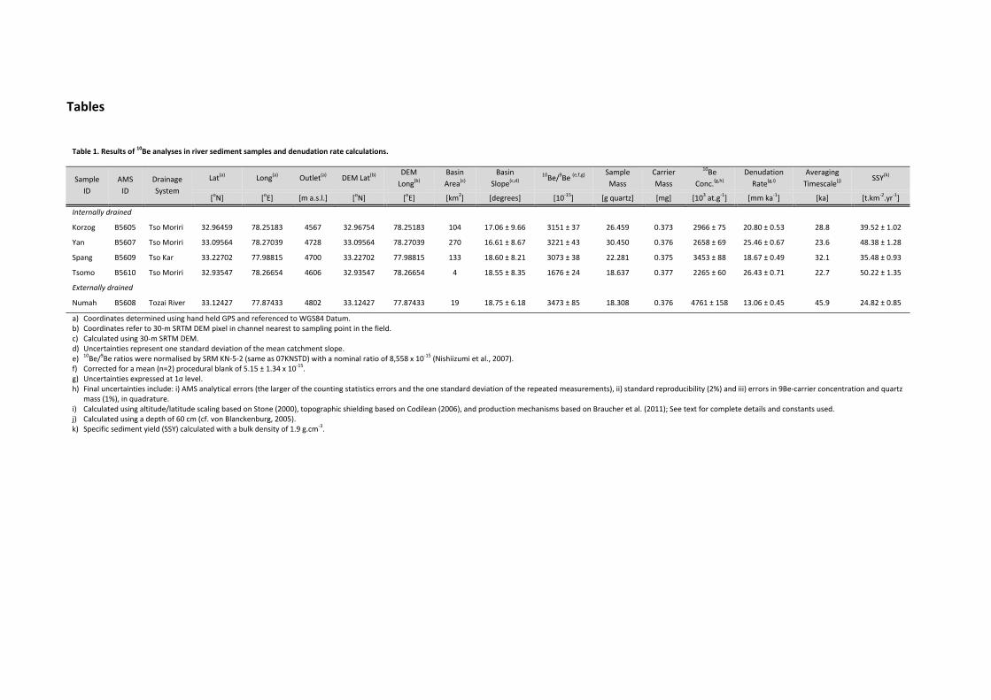
Table 1. Results of 10Be analyses in river sediment samples and denudation rate calculations.
Sample
ID
AMS
ID
Drainage
System
Lat(a) Long(a) Outlet(a) DEM Lat(b) DEM
Long(b)
Basin
Area(c)
Basin
Slope(c,d) 10Be/9Be (e,f,g)
Sample
Mass
Carrier
Mass
10Be
Conc.(g,h)
Denudation
Rate(g,i)
Averaging
Timescale(j) SSY(k)
[oN] [oE] [m a.s.l.] [oN] [oE] [km2] [degrees] [10‐15] [g quartz] [mg] [103 at.g‐1] [mm ka‐1] [ka] [t.km‐2.yr‐1]
Internally drained
Korzog B5605 Tso Moriri 32.96459 78.25183 4567 32.96754 78.25183 104 17.06 ± 9.66 3151 ± 37 26.459 0.373 2966 ± 75 20.80 ± 0.53 28.8 39.52 ± 1.02
Yan B5607 Tso Moriri 33.09564 78.27039 4728 33.09564 78.27039 270 16.61 ± 8.67 3221 ± 43 30.450 0.376 2658 ± 69 25.46 ± 0.67 23.6 48.38 ± 1.28
Spang B5609 Tso Kar 33.22702 77.98815 4700 33.22702 77.98815 133 18.60 ± 8.21 3073 ± 38 22.281 0.375 3453 ± 88 18.67 ± 0.49 32.1 35.48 ± 0.93
Tsomo B5610 Tso Moriri 32.93547 78.26654 4606 32.93547 78.26654 4 18.55 ± 8.35 1676 ± 24 18.637 0.377 2265 ± 60 26.43 ± 0.71 22.7 50.22 ± 1.35
Externally drained
Numah B5608 Tozai River 33.12427 77.87433 4802 33.12427 77.87433 19 18.75 ± 6.18 3473 ± 85 18.308 0.376 4761 ± 158 13.06 ± 0.45 45.9 24.82 ± 0.85
a) Coordinates determined using hand held GPS and referenced to WGS84 Datum. b) Coordinates refer to 30‐m SRTM DEM pixel in channel nearest to sampling point in the field. c) Calculated using 30‐m SRTM DEM. d) Uncertainties represent one standard deviation of the mean catchment slope. e) 10Be/9Be ratios were normalised by SRM KN‐5‐2 (same as 07KNSTD) with a nominal ratio of 8,558 x 10‐15 (Nishiizumi et al., 2007). f) Corrected for a mean (n=2) procedural blank of 5.15 ± 1.34 x 10‐15. g) Uncertainties expressed at 1σ level. h) Final uncertainties include: i) AMS analytical errors (the larger of the counting statistics errors and the one standard deviation of the repeated measurements), ii) standard reproducibility (2%) and iii) errors in 9Be‐carrier concentration and quartz
mass (1%), in quadrature. i) Calculated using altitude/latitude scaling based on Stone (2000), topographic shielding based on Codilean (2006), and production mechanisms based on Braucher et al. (2011); See text for complete details and constants used. j) Calculated using a depth of 60 cm (cf. von Blanckenburg, 2005). k) Specific sediment yield (SSY) calculated with a bulk density of 1.9 g.cm‐3.

Table 2. Results of 10Be analyses in amalgamated pebble surface and depth‐profile samples.
Sample ID AMS ID Lat(a) Long(a) Elevation(a) Depth Below
Surface(b) 10Be/9Be (c,d,e)
Sample
Mass
Carrier
Mass 10Be Conc.(e,f)
[oN] [oE] [m a.s.l.] [cm] [10‐15] [g quartz] [mg] [103 at.g‐1]
DP_SURF B5593 33.14162 77.81162 4765 0 22938 ± 165 36.520 0.372 15636 ± 367
DP_20 B5594 33.14162 77.81162 4765 20 20827 ± 193 42.414 0.374 12268 ± 297
DP_40 B5595 33.14162 77.81162 4765 40 21408 ± 180 43.300 0.372 12299 ± 294
DP_60 B5596 33.14162 77.81162 4765 60 18826 ± 130 40.987 0.374 11490 ± 269
DP_80 B5597 33.14162 77.81162 4765 80 17213 ± 189 38.740 0.374 11113 ± 277
DP_100 B5598 33.14162 77.81162 4765 100 13631 ± 78 38.214 0.374 8921 ± 206
DP_120 B5599 33.14162 77.81162 4765 120 13079 ± 90 42.160 0.376 7786 ± 182
DP_140 B5600 33.14162 77.81162 4765 140 14163 ± 90 44.405 0.376 8005 ± 186
DP_160 B5601 33.14162 77.81162 4765 160 11323 ± 65 45.619 0.377 6250 ± 144
PTOP B5602 33.11190 77.79445 4804 0 14343 ± 133 23.665 0.376 15228 ± 369
a) Coordinates determined using hand held GPS and referenced to WGS84 Datum. b) Topographic shielding was measured in the field and yielded a value of 0.999 for both DP_SURF and PTOP. c) 10Be/9Be ratios were normalised by SRM KN‐5‐2 (same as 07KNSTD) with a nominal ratio of 8,558 x 10‐15 (Nishiizumi et al., 2007). d) Corrected for a mean (n=2) procedural blank of 5.15 ± 1.34 x 10‐15. e) Uncertainties expressed at 1σ level. f) Final uncertainties include: i) AMS analytical errors (the larger of the counting statistics errors and the one standard deviation of the repeated
measurements), ii) standard reproducibility (2%) and iii) errors in 9Be‐carrier concentration and quartz mass (1%), in quadrature.

Table 3. Estimated erosion of valley‐fill volumes, and specific sediment yields (SSY), averaging over 135 ka
Valley Basin
Area
Min
Volume
Mean
Volume
Max
Volume Min SSY Mean SSY Max SSY
[km2] [km3] [km3] [km3] [t km‐2 yr‐1] [t km‐2 yr‐1] [t km‐2 yr‐1]
Sumka 298 2.70 3.59 4.68 127.49 169.50 220.79
Tozai 475 8.61 11.10 14.06 255.03 328.86 416.56
Sumka + Tozai 773 11.31 14.69 18.73 205.86 267.43 341.09
Zanskar* 15,000 7 ‐ 22 90 ‐ 280
Estimates from method #2 (methods and results section), based on 30‐m SRTM data, and specific sediment yield (SSY) calculated with a bulk density of 1.9 g.cm‐3. *Data from Clift and Giosan (2014), and averaged over the past 10 ka.

Figures
Fig. 1. mountaTozai casamplin(mm ka10Be sursample
Shaded reain ranges (atchments, ng locations‐1, Table 1).rface grab sand DP_02
elief of the(inset) in thand the adjs for catchm. Contributisample; wh0 to DP_16
e western he Zanskar jacent Tso Kment‐averagng catchmehite circle w0 depth pro
Tibetan PlRiver head
Kar and Tsoged cosmogent areas arwith black cofile (Fig. 4,
lateau mardwaters, re Moriri endgenic 10Be wre shaded bentre locatTable 2). Fo
rgin and thepresented orheic basiwith inferreblue. White es DP_SURor geology s
he Transhiby the Sumns. Black poed denudaticircle locatF 10Be surfasee Fig. 3.
malayan mka and oints are on rates tes PTOP ace grab

Fig. 2. Fto the nRed polpillars psection
ield photosnorth. (B) Doygon (bordpartly extenseen from t
s of the Morownstreamered by mad down to mthe Sumka
re Plains. (A view of Sumtching symmodern Sumchannel. Pi
A) Northwarmka River cbols in Fig. mka River lellars consist
rd view of tcutting >2501) is erodedevel in midgt mainly of s
he former v0 m into thed cross sectground. (C) sub‐rounde
valley floor e former vation. SedimeMore Plained very coar
dipping lley fill. entary s rse

gravels
north‐fashown iEarth‐pnorth‐fashown i
Fig. 3. GTozai cawhite o
(‐5 to ‐6 φ)acing slope in (C). Surfaillar detail wacing valleyin (G).
Geological matchments, outline). Ph
) in cemente
dotted by pace consists with ~A5‐sizy flank with
map of the Rand the int
hirtse river
ed matrix. (
periglacial sof loose grzed field bo~2‐m wide
Rupshu Platternally drasediments
(D) View fro
solifluction lavel dislodgook for scaleearth‐pillar
teau, featurined Tso Kaform an a
om terrace r
lobes. (E) Slged from coe. (G) Detailr. (H) Close‐
ring the Moar and Tso Malluvial dam
riser shown
ope detailsonsolidated of the upp‐up of valley
ore Plains (MMoriri lake m at the so
n in (C) towa
s of valley fl earth‐pillaermost ~30y‐fill sedime
MP), the Sumbasins (dotouthern end
ards
ank rs. (F) 0m of ents
mka and ted with d of Tso

Moriri nepisodicdivide contribupasses sformer (2003); et al. (2Garzant
Fig. 4. Cof deptcircles a
age (
near the drc channel a(dashed wuting catchshowing eleshoreline dfor formati010), for foti (1991), an
Cosmogenicth. Empty care correspo
13.8)
rainage diviavulsions, twith questiment areasevation in detectable ions #4, 5 (formations #nd Sciunnac
c 10Be concecircles are monding best
at ~135 ka
de betweenthus partlyon marks)s shown usmetres. Arrfrom satellforearc bas19‐28 (Tethch and Garza
entration omeasured Dt‐fit predict
assuming n
n the Indusdraining i. Black poing black orows indicaite imagerysin) see Garhys Himalayanti (2012)
of the MoreDP_ sampletions. Inset:
no surface e
s and Sutlejnto the Suoints are 1
outlines. Paiate flow diry is at 4635zanti & Vanya) see Garz.
e Plains agges (Table 2 plot sho
erosion, and
j rivers. Thetlej and sh10Be‐sampliired brackeections. PS 5 m asl. Basn Haver (19zanti et al. (
radation su) with 1σ uows best‐fit
d a bulk den
e dam is suhifting the ing locatioets are tranS = Tso Kar,se map aft988) and He(1986), Gae
urface as a uncertaintiet result of e
nsity of 1.9 g
ubject to draining ns with sfluence , highest er Steck enderson tani and
function es; filled exposure
g cm−3.

Fig. 5. headwam long and S1 –(methodGIS‐bas
eroded endorhedrainagdevoid black ce_160 deBackgroSeptem
Reconstrucaters. Grey valley cros– MP in (C).d #2 in Sected cut‐and
volumes weic Tso Kare route acrof granitic entre is posepth profileound imageber 2000 (h
cted formepoints are es sections w. Dashed botion 3.2); dad‐fill routine
with 2 error (white) coss MP andclasts; whi
sition of DPe (Figs. 1, e is pan‐shhttp://glcf.u
er valley flelevations owith 500‐mold lines shoashed thin le (method
ors. (C) Bouatchments.d down the ite circle is_SURF 10Be2, 4), TK =
harpened Lumd.edu/da
oors of (Aof raster ce
m spacing alow former slines show #1 in Sect
undaries of. HorseshoeZara River.s PTOP 10Bee surface gr= Tso Kar landsat 7 Eata/landsat/
A) Sumka alls with slopong dashedsurfaces frohypothetication 3.2; re
Sumka (rede‐shaped d Star is pose surface grab sample lake, TM =ETM+ false/).
and (B) Topes <15° exd lines T1 –m second‐oal surfaces rejected in 5
d), Tozai (yedashed lineition of 3 x rab sampleand correspTso Morir‐colour com
zai rivers, xtracted fro– MP (Moreorder polynreconstruct5.1) and es
ellow), ande marks pre10 m (d x le; white cirponding DPri lake (endmposite, R
Zanskar m 2500‐e Plains), omial fit ted from stimated
d current e‐135‐ka ) trench, rcle with P_020 to dorheic). GB 432,

Fig. 6. Rand Tozevery 2Plains ssurface sample
Reconstructzai catchme20 vertical murface; colograb sampand corresp
ted former ents; black ametres, andour spacingle, white ciponding DP
(A) and (B)arrows indicd highlightsg scales invercle with blP_020 to _1
modern tocate flow ds <10°‐slopeersely withlack centre 60 depth pr
opography oirections (Fes of inferrslope gradiis position rofile samp
of the Moreigs. 1, 3). Cored former ient. Whiteof DP_SURles (Figs. 1,
e Plains andolour rampand mode
e circle is PTRF 10Be surfa2, 4).
d Sumka p repeats rn More TOP 10Be ace grab
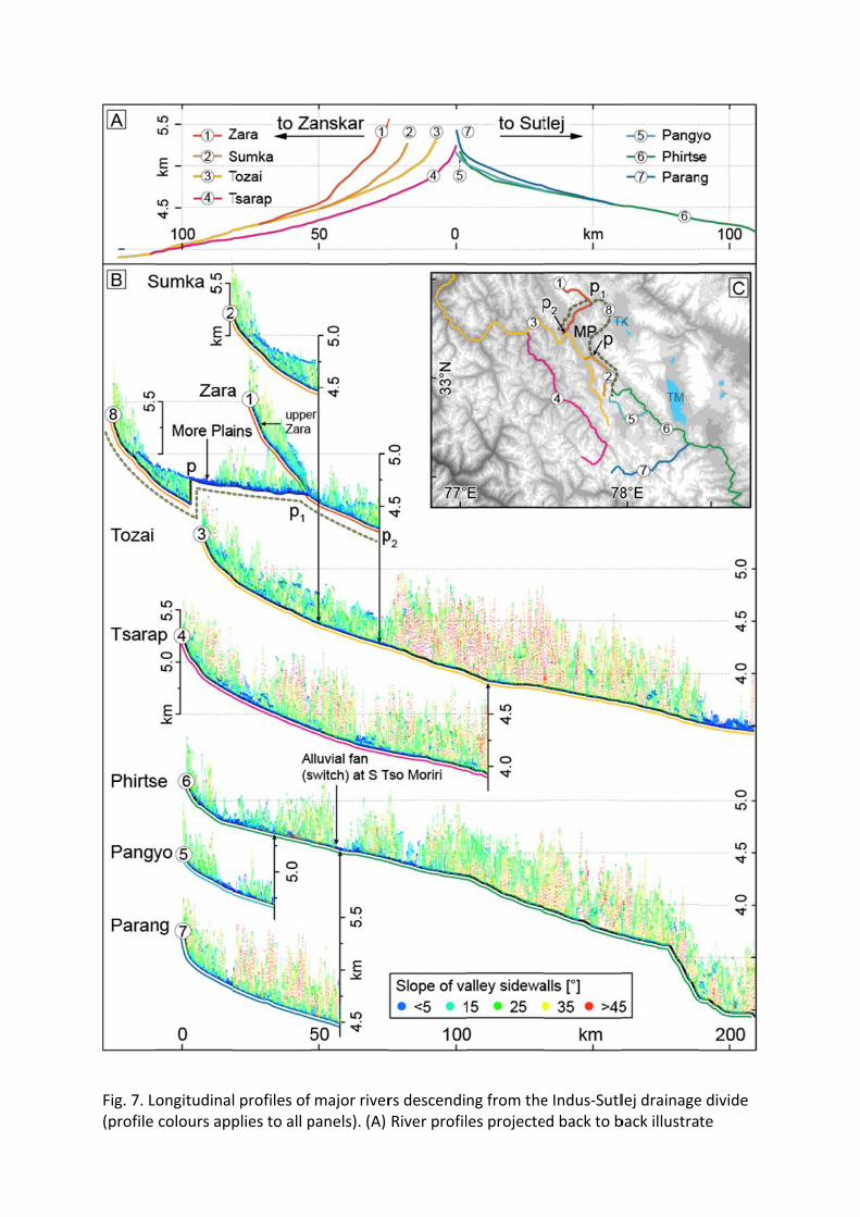
Fig. 7. L(profile
ongitudinalcolours app
l profiles of plies to all p
major riverpanels). (A)
rs descendiRiver profil
ng from theles projecte
e Indus‐Sutled back to b
lej drainageback illustra
e divide te

differensteeperslope/eand dowcapturerecent Z
Fig. 8. geomorterrace Himalay
nces in vertir profiles towlevation pixwnstream ee dashed in Zara – Tozai
Transhimalrphic markesurface ag
ya‐Tibet oro
ical drop pewards the Zxels along 2end of horse(B) and (C),i confluence
layan late ers. (A) Reges; trianglogen (Owen
er unit lengtZanskar (Ind‐km wide sweshoe‐shape and offset e. (C) Locati
Quaternaryegional ovee is a fan n et al., 20
th betweendus). (B) Lonwath cross‐ed Zara rivein (C) for beion of rivers
y landscapeerview of tsurface of
006; recalcu
upper Indungitudinal p‐profile, reser segment etter graphs (MP = Mo
e evolutionhe Transhif oldest daulated by B
us and Sutleprofiles withpectively. ‘pthat was cuical represere Plains).
n – synopsmalayan raated glacial löthe et al.
ej rivers, with stacked p’ and ‘p1’ mut short by sentation; ‘p
sis of selecanges. Squa succession., 2014); cir
th
mark up‐ stream
2’ marks
cted key ares are n in the rcles are

moraines used for glacial chronologies; lavender areas are modern glaciers (Pfeffer et al., 2014). (B) Monsoon proxies compiled from Wang et al. (2001, Hulu cave), Wang et al. (2008, Sanbao cave), Cheng et al. (2012, Kesang cave), and Berger and Loutre (1991, insolation); marine isotope stage substages after Winograd (1997, duration), and Lisiecki and Raymo (2005). (C)–(E) Key geomorphic marker ages. Blue dots are mean ages of glacial advances with reported uncertainties (except for ‘In’, where error bars extend to youngest and oldest age); grey circles are scaled to maximal glacier advance relative to recent extent; orange bars are major damming phases. Squares are aggradation surface ages with external uncertainties. For consistency, we recalculated the data with the CRONUS online calculator (http://hess.ess.washington.edu; Balco et al., 2008) using the 10Be SLHL spallation production rate of Heyman (2014). Data compiled from Dortch et al. (2010, 'Do'), Scherler et al. (2014); Owen et al. (2006, 'In'), Hedrick et al. (2011, 'P' and 'K'), Taylor and Mitchell (2000, 'Z'), and Blöthe et al. (2014).