Embed Size (px)
Citation preview
In Coastal Virginia, flooding has been an on-going issue.
Flooding is caused by precipitation events, high tides or storm surge. Although flooding has occurred throughout recorded history, increased flooding frequency or damage is often linked to increases in development. Impacts from flooding can range from temporary road closures to the loss of homes, property and life. In coastal Virginia, the cost of large storm damage can range from millions to hundreds of millions of dollars per storm (VDEM, “Hurricane History”). With a long history of flooding from coastal storms (the first reference to storm-related flooding was in 1667), there is an understandable interest in Virginia of identifying areas of potential flooding and establishing measures (adaptation strategies) to reduce the impact of future flood events.
Recurrent Flooding Study
Fall 2012, Vol. 7, No. 2
Shifting climatic conditions, such as sea level rise and changes in the frequency or intensity of storms, are predicted to increase flood damage. Predicting the impact of these changes allows localities to target adaptation strategies which will mitigate both current and future flooding. Practically, only sea level rise changes can be predicted with any level of confidence. Although some research has
been done on changes in storm patterns, Virginia receives heavy precipitation from both tropical systems (tropical storms and hurricanes) and Nor’easters, which respond to different climatic forces. This makes changes in precipitation patterns difficult to predict. Therefore, most work on future predictions of flooding are focused on areas subject to storm surge and tidal flooding.
This diagram shows the causes of flood damage and connections between factors that can worsen or mitigate flooding risk and vulnerability.
Flood Sources Changing Conditions
Adaptation Strategies
Floodplain Occupancy
Rainfall &Snowmelt
Extreme Tides
Storm Surge
Development
Storm Frequency/ Intensity
Sea Level Rise
Management/ Retreat
Accommodation
Protection
InfrastructureResidencesBusinessesAgriculture
People
Risk ConsequencesFlood
Damage
2 Rivers & Coast
Rivers & Coast is a biannual publication of the Center for Coastal Resources Management, Virginia Institute of Marine Science, College of William and Mary. If you would like to be added to or removed from the mailing list, please send correspondence to:
Rivers & Coast/CCRM P.O. Box 1346
Gloucester Pt., VA 23062 (804) 684-7380 [email protected]
CCRM Director: Dr. Carl Hershner
Contributing Authors: Molly Mitchell, Dr. Carl Hershner
Illustrations: Molly Mitchell, Dr. Carl Hershner, Dr. Julie Herman
Photographs: Karen Duhring, FEMA, Carolyn Kaster
Layout: Ruth Hershner
This report was funded, in part, by the Virginia Institute of Marine Science and by the Virginia Coastal Zone Management Program of the Department of Environmental Quality through Grant #NA11NOS4190122 Task #8 of the National Oceanic and Atmospheric Administration, Office of Ocean and Coastal Resources Management, under the Coastal Zone Management Act, as amended. The views expressed herein are those of the authors and do not necessarily reflect the views of NOAA or any of its subagencies or DEQ.
Printed on recycled paper
2
Causes of FloodingPrecipitation events typically cause flooding when the intensity of runoff exceeds the capacity of the stormwater drainage systems. This results in a backup of water into roads, homes and businesses. Precipitation based flooding in Virginia occurs in both urban and rural areas, in coastal and non-coastal areas. It worsens when the frequency of heavy rain events increase or when new development increases the load on existing drainage systems.
High tides cause flooding in low-lying coastal areas. Typically, areas flood only during extreme high tide events, frequently due to storm-related pressure systems. However, some areas in Virginia may flood on spring tides (which occur semi-monthly). Flooding from high tides can worsen due to coastal erosion or sea level rise.
Storm surge flooding is caused by large storms (hurricanes, tropical storms, and nor’easters). These storms are associated with pressure systems and intense winds which cause water to pile up against the coast. Storm surges can affect large areas of coastal lands, but the extent of flooding depends on the characteristics of the particular storm and the direction it approaches the coast. Flooding tends to be worse when the storm hits during high tide (thus combining tidal flooding with storm surge flooding). Storm surge flooding will worsen with increases in sea level, and an increase in the frequency and intensity of large storm systems.
Where Does Flooding Occur?
Flooding in coastal Virginia typically occcurs at low elevations. Storm surge and tidal flooding are entirely elevation based, while precipitation driven flooding can occur where ever stormwater drainage systems are inadeqate to handle the runoff. Practically, this is frequently also at low elevations, where flat land slows runoff and tide levels can reduce the capacity of storm drains.
Information on areas that are vulerable to flooding can be found from a variety of sources. The most well-known maps are the FIRM (Flood Insurance Rate Maps) produced by the Federal Emergency Management Agency (FEMA). FIRM maps are avalable for the entire coastal area of Virginia, and can be found at: http://www.floodsmart.gov In the FIRM, floodplains and areas subject to coastal storm surge are shown as high-risk areas (called “Special Flood Hazard Areas” or “SFHAs”).
Storm surge maps are also common. They are predictions of storm surge flooding depths resulting from historical, hypothetical, or predicted hurricanes. The model used for making these predictions is known as the SLOSH (Sea Lake Overland Surge for Hurricanes) model. It was

3Fall 2012,Vol. 7 No 2
Figure 1. Gloucester Elevations and Storm Surge. Gloucester County, VA. The map on the left shows land elevations; darker areas are higher, lighter areas are closer to sea level elevation. The map on the right shows predicted storm surge flooding for different category storms. Notice the connection between low elevations and flood risk.
developed by FEMA, United States Army Corps of Engineers (USACE), and the National Weather Service (NWS). These maps are available at: http://www.vaemergency.gov/readyvirginia/stay-informed/hurricane/storm-surge
It is important to note that both sets of maps described above are based on the probability of flooding occurring; some areas in the hazard zones may experience frequent flooding while others are only affected by severe storms. Also, flooding may occur in areas outside of the hazard zones. Historic flood information is harder to find. Virginia Department of Transportation (VDOT) has begun to maintain a database of road closures due to flooding (Figure 2), which shows how widespread flooding is throughout coastal Virginia. FEMA collects information on properties with repetive losses (due to flooding), which some localities have made available (typically in their Hazard or Floodplain Mitigation Plans) but it is not widely available to the public.
Effectively managing flooding requires that flood risk be a consideration at all levels of planning. The challenge for appropriate flood management planning is to reduce risks to people, property and ecosystems associated with existing development while managing or preventing new development in high risk areas. This goal can be accomplished through a variety of adaptation strategies. Adaptation
Figure 2. This map shows VDOT maintained roads that have been closed due to flooding over the past four years. The size of the dot indicates how many times the road has been closed during that time period.
strategies fall into 3 main categories: Management/retreat (zoning policies and similar), Accommodation (elevation of roads and buildings, evacuation scenarios, etc) and Protection (hard and soft engineering strategies).
Most localities have addressed flooding and flood mitigation strategies to some extent, either through zoning policies, floodplain management ordinances, comprehensive plans, floodplain management plans or hazard mitigation plans (which are typically regional plans). Few localities have detailed adaptation strategies, and there is little integration between state and local planning efforts or between planning efforts in adjacent localities.

4 Rivers & Coast
Adaptation Strategies for Flood Management
Strategy DescriptionExamples
rolling easement allow wetlands or beaches to migrate inland as sea levels rise
ecological buffer zones conserve natural habitat for plants and animals ecosystem protection and restoration
encourage corridor connectivity and restoration of native aquatic and terrestrial habitats
open space preservation and conservation
preserves undeveloped areas, can be used to store floodwaters
invasive species management
preserving native species/preventing spread of invasive species, under anticipated conditions of climate change
zoning restricts types of use appropriate for a parcel of land
redevelopment restrictions restrictions applying to a structure that is destroyed or substantially damaged.
conservation easements restricts use of areas, can be used to store floodwaters
compact community design reduces the footprint of development
government purchase of development rights
provides landowners with compensation for their farmland or other property in order to prevent development
acquisition, demolition, and relocation
federal, state or local government buyout of at riskproperties
horizontal setbacks require development be located a fixed distance landward
vertical setbacks require development be located landward of a fixed elevation
insurance incentives/disincentives
cost of insurance, based on flood risk, can create adisincentive for building in high risk areas
emergency response plans detailed plan for managing floods
early warning systems siren or telephone warning system
building codes guidelines for construction and land use in areas likely to be inundated
retrofitting elevating, reinforcing, bracing and anchoring flood-prone structures, removing impervious surfaces, etc.
raise roads raising the elevation of parts of or a whole road
floodplain storage create dry basins for holding storm waterintegrated flood management
public infrastructure vulnerability reduction
relocation or institution of flood proofing measures for vulnerable drinking water and wastewater facilities
shore protection structures typically levees, which are a "wall" of earth and concrete designed to prevent flooding behind them
coastal hardening seawalls, revetments, breakwaters, groins etc.
floodgates or tidal barriers gates placed in a waterway that can open and close to control high tides, storm surges or flood waters
stormwater management stormwater drainage and storage systems to move water off roads and away from houses
green infrastructure measures aimed at slowing or retaining stormwater, includes green roofs, rain gardens, parks, etc.
beach nourishment addition of sand to an existing beach to widen dune building artificial creation or enhancement of a shoreline dunes
wetland creation artificial creation or enhancement of a wetland for shore stabilization and ecosystem services
man
agem
ent/r
etre
atac
com
mod
atio
npr
otec
tion
coastal and marine management
growth and development management
loss reduction
emergency management
loss reduction
loss reduction
water resource management and protection
soft engineering

5Fall 2012,Vol. 7 No 2
Acquisition, Demolition, and RelocationAdvantages: Minimizes human suffering from severe events, less expensive than armoring strategies in very low-density or uninhabited areas, can allow for ecological restoration. Disadvantages: More expensive than armoring strategies in high-density areas, loss of communities and private property values, political quagmire with legal and equity issues.
RetrofittingAdvantages: Removes development from immediate threat of flooding, may reduce flood insurance premiums, property owner can control elevation of structure.Disadvantages: Expensive to retrofit existing development, not useful in areas with permanent flooding, adding fill and raising grades may impact adjacent properties, wetlands and other habitat.
Shore Protection StructuresAdvantages: Protects large areas of land with a single structure.Disadvantages: May fail leading to unexpected losses or may contain stormwater leading to flooding.
Beach NourishmentAdvantages: Reduction of intensity and frequency of flooding; preserves or increases valuable habitat; provides recreation and open space areas.Disadvantages: Extensive land required to provide benefit, continued maintenance required.
Wetland CreationAdvantages: Reduction of intensity and frequency of flooding; preserves or increases valuable habitat; provides recreation and open space areas, reduces water pollution and enhances groundwater recharge. Disadvantages: Extensive land required to provide benefit, continued maintenance required.
Floodgates or Tidal BarriersAdvantages: Protects a huge area of land from flooding with one project, protects everyone, no social equity issues. Disadvantages: Expensive, ecologically transformative and damaging.
Elevated house in MississippiPhoto by Robert Harris/FEMA Deltaworks in the North Sea
Created marsh in VirginiaPhoto by K. Durhing
Moving to higher groundPhoto by State Agency/FEMA
Beach nourishmentPhoto by Karen Duhring
Levee in North Dakota Photo by Andrea Booher/FEMA

6 Rivers & Coast
Sea Level Rise in Virginia
Sea level in Virginia is affected by three general factors: the volume of water in the ocean, the elevation of the Virginia shoreline, and the movement of water in the ocean. All three things have been changing in recent times. The result for coastal Virginia has been a long-term, and recently accelerating rise in the level of tidal waters in the Commonwealth.
The first factor—the volume of water in the ocean—is simple to understand. Increasing the volume of water in the ocean will unavoidably raise the water level at the shoreline. Two things are currently causing the volume of ocean water to increase. Glaciers, ice caps, and ice sheets in Greenland and Antarctica are melting, adding water that was stored on land surfaces to the ocean basins. At the same time, the water in the oceans is warming causing it to expand.
The second factor—the elevation of Virginia’s shoreline—is surprising for many people living here. It turns out that Virginia’s coast is sinking. The primary cause is the continuing adjustment of the earth’s crust to the melting of glaciers from the last ice age. As the glaciers, that once extended south to what is now northern Pennsylvania, melted and retreated northward, the land under them began to rebound. As that area rose, the mid-Atlantic region began to sink.
The third factor—the movement of water in the ocean—may explain some of the increasing rate
of rise. As water moves north in the Gulf Stream just off our coast, the Coriolus force drives water to the right and away from our coast. The amount of water moved is related to the speed of the current, and the speed of the current is dependent on how cold things are near Greenland. As that area warms, the current slows, and the water along the coast rises.
Looking forward, sea level rise is anticipated to continue, and the rate of rise may well continue to accelerate. We do not anticipate the subsidence rate for the Virginia coastal region will change, so it should remain a constant factor. Current understandings of global atmospheric processes indicate temperatures will continue to rise for at least the rest of the century. We are not certain how high they may go, but at a minimum this will sustain current trends in glacier and ice cap melting, as well as thermal
expansion of ocean water. What all this means is that we will see higher sea levels in the future, they will probably rise more rapidly than they have in the last century, and potentially they will rise much more rapidly.
The long range, end-of-the-century sea level rise forecasts have significant uncertainty, with projections for our region of anywhere between +1.5 and +7.5 feet. Given what we currently know, we believe it is prudent to plan for what we anticipate may happen over the next 20 to 40 years, while committing to close observation of trends to better estimate longer term outcomes. Within this period, we will experience a 1.5 foot rise in sea level under most scenarios. It will come at the beginning of the period under the worst case scenarios, and at the end of the period for the more modest scenarios.
0
1
2
3
4
5
6
7
8
1992 2020 2040 2060 2080 2100
sea
level
rise
(feet
)
Year
SE Virginia sea level rise scenarios
highest
high
low
lowest
Southeast Virginia sea level rise scenarios based on global climate change predictions plus local subsidence. Highest = based on plausible maximum glacier and ice sheet contributions. High = high end emissions scenario. Low = low end emissions scenario. Lowest = extrapolation of the historical trend (does not reflect higher rate observed over last decade).
7Fall 2012,Vol. 7 No 2
Impacts of Sea Level Rise
Sea level rise will increase the vulnerability of human infrastructure and natural resources to flooding. Human infrastructure at risk includes: houses, businesses, roads, tunnels, airports, stormwater and sewer systems, and utilities.
There are three major threats to road systems from rising sea level: alterations to the drainage capacity, flooding of evacuation routes, and increased hydraulic pressure on tunnels. Most roads have some type of drainage system, which are typically built at a lower elevation than the surrounding land to drain properties. These drainage systems rely on hydraulic head (a slope to the waterway) to drain properly. As sea level rises, that slope declines, decreasing the capacity of the drainage system. This can cause stormwater to back up or pond, causing flooding. In areas subject to storm surge flooding, rising sea level may cause the road to flood earlier, potential cutting off evacuation routes. Tunnels are used throughout southeastern Virginia to ensure navigability of channels. A higher water table (due to sea level rise) results in increased hydraulic pressure on the tunnel structure.
Sewage systems, similar to stormwater drainage systems, rely on hydraulic head to function effectively and are designed based on historic waves, water levels and rainfall. Sea level rise will reduce hydraulic head and increase tide
levels. Where hydraulic head is not sufficient, pumps must be used to move sewage. High tides and storm surges can block the discharge of treated sewage, causing back-ups. As sea level rises, this can become a more frequent occurrence. In areas with septic systems, rising sea level can elevate the water table (ground water) causing reduced function.
Sea level rise is also predicted to increase coastal erosion. In coastal Virginia, many roads and houses are adjacent to waterways. Erosion of the shoreline adjacent to these roads puts the roads at risk of collapse, potentially cutting off access to multiple houses.
Many of our coastal resources are critical components of a natural system to reduce coastal flooding
impacts. Long shallow water stretches break waves, reducing their energy before they strike the shore. Beaches and marshes can act in the same way, protecting upland development. Marshes can also absorb floodwaters and excess precipitation, reducing flood duration, decreasing runoff “flashiness” and promoting groundwater recharge. Dunes act as natural levees and help prevent coastal erosion. Natural resources such as these are being engineered throughout the world to reduce impacts of flood events. Sea level rise and coastal erosion eat away at the extent of marshes, beaches and shallow water areas, reducing both their extent and their capacity to reduce flooding impacts.
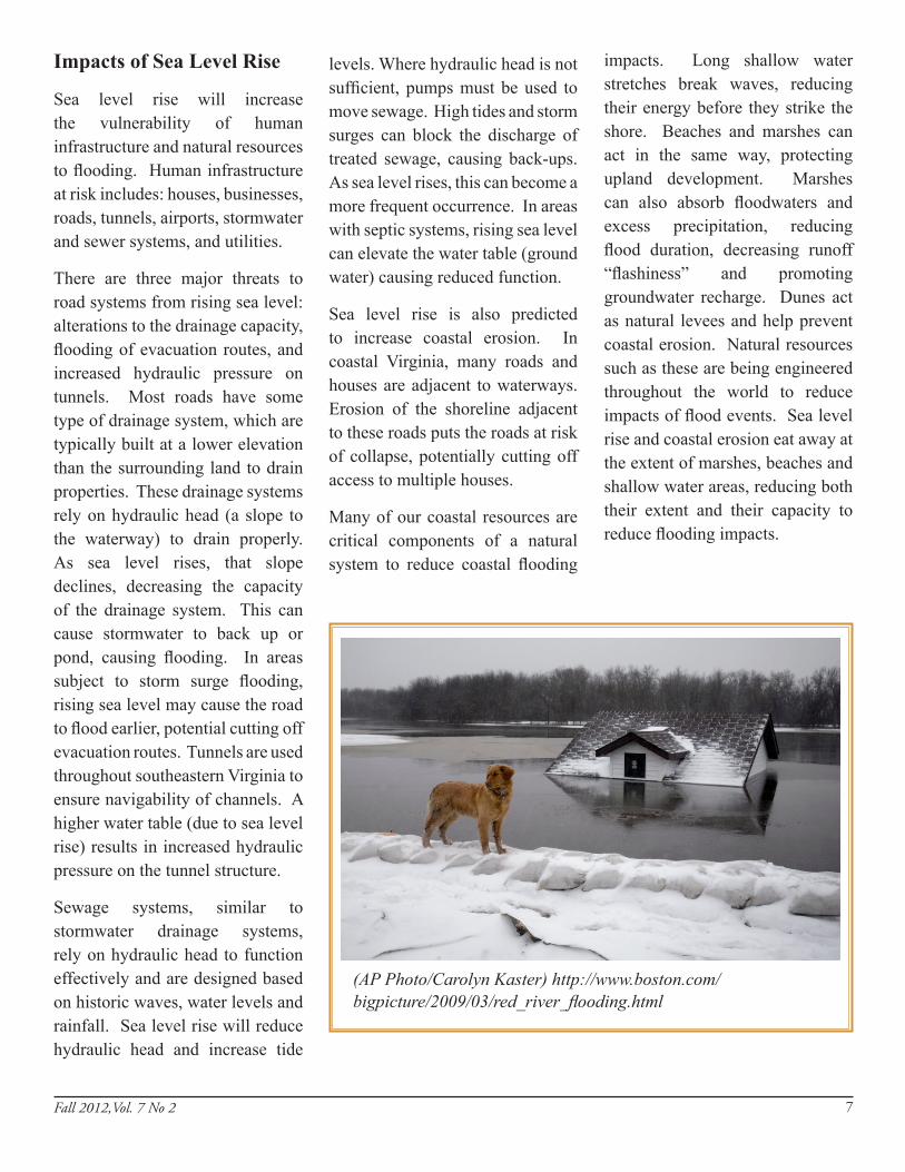
(AP Photo/Carolyn Kaster) http://www.boston.com/bigpicture/2009/03/red_river_flooding.html

Study InformationThe Virginia Institute of Marine Science has been directed to undertake a Recurrent Flooding Study for the Virginia General Assembly. The study will address flooding in all localities in Virginia’s coastal zone.
The purpose of the study is twofold. First, it will summarize what is currently known about the risks of recurrent flooding due to tidal flooding, storm surge, sea level rise and precipitation runoff in Virginia’s coastal zone. Second, it will inventory and provide a preliminary assessment of suitable adaptation options available for Virginia coastal localities experiencing recurrent flooding. The study will provide the background information for the legislature to determine if the state should undertake further risk mitigation planning and implementation in collaboration with local and/or federal government. It will also provide the general background localities may need for individual pursuit of additional planning and implementation resources.
The study is being undertaken with the collaboration and assistance of Old Dominion University, the Hampton Roads Planning District Commission, the University of Virginia’s Institute
for Environmental Negoti-ation, Wetlands Watch, and relevant state agencies. Data is being collected from multiple local, state, and federal agencies, as well as NGOs and regional authorities.
We will be convening a stakeholder advisory panel composed of stakeholders from localities, state and federal government and industry. The stakeholders will advise on flood risks extent and magnitude as well as management actions for flood mitigation appropriate to Virginia localities.
8
D D D D
Legislative Perspective
Figure 3. Map of Localities. The green areas on the map show localities included in the study. A list of localities is on the side of the map.