Embed Size (px)
DESCRIPTION
A fantastic guide for RAAus members and aviators alike. Great information on flying safely.
Citation preview
A Recreational Aviation Australia
Safety Initiative

Contents
Members will have read recent articles in Sport Pilot magazine by the Operations, Safety and Technical Managers relating to our shared responsibilities to fly safely and make good decisions.
Our privilege to fly directly impacts on our ability and willingness to create a safer sky for all. Each of us wants to be safe when we venture into the big blue, as do our families and loved ones who wait for our return. However, human nature and ego sometimes blind us to the dangers we can take for granted.
Being aware of your own safety culture and attitude is the first step towards a national change of attitude in recreational aviation. Being aware of others’ safety culture and attitude is the second step. Sometimes it is not just a mistake pilots make when they make a poor decision. So if you see something you believe is not in the best interests of safety, then say something. Make it known that this is not how things are done around here.
Sport Pilot magazine October edition has a dedicated focus on safety. Recent serious and fatal accidents have highlighted the need for renewed focus on pilot decision making. It is also an ongoing RA-Aus commitment to reduce accidents. There are many subjects contained in the following pages which are aimed at reducing accidents. You will find articles in this edition ranging from Low Flying, Fuel Management, and RPT Safety
We hope you will use this guide as a valuable resource and carry it in your flight bag to help you with pre-flight planning and conducting your flights safely.
At RA-Aus, your safety is our priority. But remember - how we act as aviators today paves the way for our freedoms tomorrow.
Michael LinkeCEO Recreational Aviation Australia
Welcome
Contents
2 Introduction
4 Low flying, wire strikes, and other low level activities
6 Fuel to go
8 Weather forecasts and reports
16 10 tips for a successful flight
18 RPT Safety and RA-Aus Operations

When we come out of hibernation after winter, our thoughts turn to the anticipated good weather for
our kind of aviation. Lots of fun, things to do and places to go in our trusty mechanical steeds. How easy it is to permanently spoil our day by hitting power lines or operating at low level without appropriate training or good reason.
Our type of flying should not ordinarily put us in danger of a wire strike, however low flying due to stress of weather, operations at private strips, paddocks, a moment’s inattention or deliberately deciding to break the law, will make us all vulnerable to wire strike or controlled flight into terrain.
If you plan to do a beat up – DON’T and a spur-of-the-moment beat up is a DOUBLE DON’T!
A few tips are worth considering which may save your bacon (and the rest of you for that matter).
◊ Before doing a navigation exercise, study all available topography charts for power lines and even mark those which could cause you a problem if
you have to fly low due to weather. Local power companies maintain maps of power line locations and some navigation software even plots wires on your flight plan.
◊ Start the flight with a clean windscreen. An old ag pilot trick is to not clean the windscreen ‘horizontally’ because residual marks may obscure a power line.
◊ If the visibility is poor due to weather or low cloud, slow the aircraft down and select some flap to give you more time to react and better forward visibility. (Neither of these options may be available in some aircraft types.)
◊ Watch for false horizons because if you are flying in unusual attitude you can lose height dramatically (and a recovery may not be possible at low level), or hitting a power line is not a good option.
◊ Remember also your altimeter may not be much help to determine your height above the ground. Some pilots find it helpful to judge height by mentally considering a relationship to known circuit height or turning final height.
◊ Do not fall for the old trick of slightly rising ground and decaying airspeed to ‘hold height’.
◊ Scud running and entering cloud can also spoil your day. Develop (situationally speaking) eyes in the back of your head and think about a way out or a suitable area to do a precautionary landing.
◊ Experienced pilots may actually fall into the trap of flying too high in bad weather. The old tail-in-the-cloud trick can significantly reduce forward visibility and increase the chances of entering cloud. A hundred feet or so lower can often improve visibility and allow the view of a more definitive horizon while not greatly increasing the chances of hitting a power line.
◊ Do not fly between peaks of hills or mountains unless you know for sure there are no wires between them.
◊ Also watch for downdrafts in mountainous terrain as being ‘snatched by a wire’ can also be a final consequence.
◊ Finally, if you intend to operate below 500ft, remember RA-Aus has a specific
endorsement and training for flights at low level, which requires training with a specialist instructor, who will not only teach you what to do, but more importantly what not to do in this unforgiving area. He or she may also have some life-saving stories or tips which they have learnt over the years, which may save you making those same mistakes.
◊ If you are working with stock and have never trained for this very demanding and specialised role, talk to Operations directly about risk mitigation strategies and training, seek out the experienced mustering pilots in the area and talk to them. Better yet, don’t get tempted to try it without training. Stick with the quad bike, motor bike or horse and get the job done safely on the ground.
This is not meant to be a sermon, but a few top tips to save your life by ‘not taking a wire’ – leave that to professional pilots who land on aircraft carriers.
Low flying, wire strikes, and other low level activities
4 5

Pilots should ensure they have a clear understanding of the fuel system of their aircraft, including fuel tap positions, cross feeding issues, water drains and a realistic fuel use per hour.
Flights in the local area may give you a false impression about the number of litres per hour the aircraft uses, because different power settings may used locally than those used flying long distances.
As well, changes in the fuel use of an engine from when new can result in fuel use rates which differ from the published figures.
Pilots can also forget to factor in time in circuit, approaches and departures, which along with climb to altitude, or changes to altitudes while chasing clear non-turbulent air, can result in higher fuel use than expected.
Finally, if fuel planning is not based on confirmed amounts of fuel via dipstick or number of litres added, an engine failure from fuel exhaustion may result, with pilots then having to deal with the extra pressure of an emergency landing.
Careful study of the Pilot Operating Handbook for the aircraft can give you a clear understanding of the fuel saving possible when operating at reduced RPMs, which may result in a slower airspeed, but offer significant reductions in fuel used for the time aloft.
When planning any flight, local or for a major trip, some key to consider include:
Have I planned where I can get additional fuel and confirmed it is the right octane rating and grade of fuel?
Am I carrying enough fuel to allow for adverse weather, scenic flights to attractions in the area, with consideration of my aircraft’s maximum take-off weight limitations?
Will requests from passengers result in distractions, can other aircraft carry extra fuel for me?
Is that extra fuel container legal and safe to be used?
Listed below are key elements that must be complied with when carrying fuel on board a private aircraft:
• The storage container must be an approved type and in good condition for the carriage of fuel.
• It must be secured appropriately, not exceed luggage limitations or be stored contrary to load limits outlined in the aircraft POH.
• The MTOW of the aircraft must never be exceeded.
• The container must not cause interference with any flight controls.
• Passengers must be advised before boarding that that dangerous goods are being carried.
Further considerations should also be given to a risk management assessment of the following:
• Will expansion in flight affect the integrity of the fuel container?
• Could there be any fumes or odours in the cockpit?
• Is there a potential for static discharge during transport?
• Can the container be appropriately bonded to transfer the fuel when on the ground?
• Can the refuelling points safely be reached on the ground?
• What plan can be put into place if a container vents, or leaks during flight?
• Is there a safer alternative by carrying an empty container and filling up once on the ground?
Proper planning prevents poor performance!
Fuel to go
Fuel mismanagement, exhaustion and/or starvation continues to be a major factor in serious and fatal accidents.
6 7

If three or more of the following seven points change significantly while you are in flight, you should turn back or divert.
(You’ll be in good company with all the other experienced pilots, and have a good story to tell when you get back to the bar!)
• Changing wind direction and speed• Darkening clouds• Increasing cloud cover• Lowering cloud base• Rain showers• Reducing visibility• Rising ground
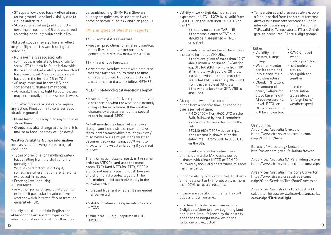
The information in aviation weather forecasts and reports is always laid out in the same way, with the information occurring in the same order. All pilots need to know is the abbreviations which are used. You can quickly discover if that flight you’re planning later today will be successful, or whether the weather will prevent your flight.
Of course you check the forecasts before you go, but sometimes the weather doesn’t behave the way you predicted it to. When you plan your route, you should consider where you could divert to in case of bad weather, that way you don’t need to think about where to go if the weather turns.
But how do you decide if you should press on, turn back or divert to an alternate landing place?
Simple:
(You should probably start considering your options even if only two points change.)
It’s worth finding a way to keep checking what the weather is doing where you’ve just come from; if you do need to turn back the last thing you want is to discover that the weather is now worse behind you!
Area Forecasts (ARFOR)As the name suggests, they cover a specific – moderately large – area of Australia, and predict what the weather will be like. Each section of the ARFOR has a plain English title, so you know what information you’re looking at. ARFORs are most easily found on the Bureau of Meteorology website here: http://www.bom.gov.au/aviation/forecasts/arfor/
VALIDITY PERIOD is shown by two 6-digit date/times. Aviation forecasts use:
• the 24 hour clock, and• UTC (Coordinated Universal Time), aka
ZULU time (abbreviated as Z), and formerly known as Greenwich Mean Time.
Conversion from UTC to:
EST +10Eastern Standard Time
CST +9.5 (9 hrs, 30 min)Central Standard Time
WST +8Western Standard Time
If you’re in a state which adds an hour during the summer then during the summer, add an extra hour to the appropriate standard time above. (E.g. ESST +11, CSST +10.5, WSST +9)
e.g. ARFOR AREA FORECAST 062300 TO 071100 AREA 21.
ARFOR validity period in Central Standard Time: from 8.30am on the 7th to 8.30pm on the 7th.
Note: if the middle two digits in the date/time group are greater than 24 after you’ve converted from UTC, add 1 to the first two digits and subtract 24 from the middle two digits. So above: 062300 +9.5 → 063230 → 070830.
OVERVIEW gives a fairly plain English summary of the forecast, usually using the following abbreviations:
• aerodrome codes – look them up in ERSA or online and the Airservices website,
• cardinal points of the compass – N=North etc, and
• Z=ZULU time – see above.
WIND expressed as direction & speed on a 3-digit/2-digit group at different heights.
• Heights are feet (FT) above mean sea level (AMSL) – found on the first row.
• Wind direction is from True North, 3-digits, rounded to the nearest 10° - found on the second row.
• Wind speed, 2-digits, is expressed in knots (KT) – also on the second row, after the /.
(MS=minus, the number refers to the temperature at that height.)
CLOUD starts wherever the lowest level of cloud is and works up, detailing the cloud type(s) and coverage.
• To quantify cloud cover, the sky is divided into eigths, called OKTAS, e.g. 4 OKTAS is half the sky.
• Information is shown in the following order, using abbreviations: amount of cover; types of cloud; height(s) of cloud (Please refer to Table 1 on page 10).
ARFORs also note the location of clouds if relevant after the quantity, type and height.
e.g. CLOUD:
BKN ST 2000/3500 W SLOPES, 3000/4500RANGES AS PER LOW CLOUD IN OVERVIEW
SCT CU/SC 3000/10000 SEA/COAST
SCT CU/SC 4000/8000 W SLOPES,5000/12000 RANGES.
BKN AC/AS ABOVE 10000 IN SE,CONTRACTING E OUT OF AREA BY 05Z.
As VFR pilots of recreational aircraft, the cloud types at low level are the ones which are most likely to affect your flight. Clouds found at low level can be anything from approximately 200 feet thick (ST) up to well over 15,000 feet thick (TCU & CB). Watch out for the following dangers:
• CU clouds, if smaller, “fine weather” CU, don’t usually present many problems BUT can develop very quickly into TCU and/or CB... keep an eye on them.
• CB generally means extremely turbulent weather, low ceilings and poor visibility. They usually also come with thunder, lightning, rain, snow and hail; TCU can be almost as bad. Avoid these!
Weather forecasts & reports
e.g. WIND:
2000 5000 7000280/20 270/25 270/25
10000 14000 18500270/25 MS05 260/35 MS12 260/40 MS22
continued on page 128

CLO
UD
SAmount of Cloud Cover Types of CloudSKC = Sky Clear 0 OKTAS CU Cumulus
Low Levelusually from surface
up to 8 500FT
FEW = Few 1-2 OKTAS TCU Towering Cumulus
SCT = Scattered 3-4 OKTAS CB Cumulonimbus
BKN = Broken 5-7 OKTAS ST Stratus
OVC = Overcast 8 OKTAS SC Stratocumulus
Height(s) of cloudAS Altostratus Mid Level
usually from 8 500-20 000FT
AC Altocumulus
Cloud base shown in FT AMSL. If there is a range, the minimum is shown, then a forward slash, then the maximum.
NS Nimbostratus
CI Cirrus High Levelusually above
20 000FTCC Cirrocumulus
CS Cirrostratus
PR
ECIP
ITAT
ION
, VI
SIB
ILIT
Y, &
SI
GN
IFIC
AN
T W
EATH
ER
Precipitation Visibility StormsDZ Drizzle BR Mist DS Dust Storm
GR Hail DU DustFC Funnel Clouds
(tornado or waterspout)IC Ice Crystals FG Fog
SH Showers FU Smoke PO Dust Devils
SN Snow HZ Haze SS Sandstorm
SQ Squalls SA Sand TS Thunderstorm
RA Rain 9999 10+km
AR
FOR
Info
rmat
ion
Ord
er (h
as s
ectio
n tit
les)
Issue Time
Forecast Type
Validity Period
Location covered
Weather Overview
Wind - direction speed
Cloud - cover/amount, type, height
Precipitation
Visibility
Freezing Level & Icing
Turbulence
Other special remarks or significant weather
TAF/
MET
AR
/SP
ECI/
TTF
Info
rmat
ion
Ord
er
(NO
sec
tion
titl
es)
Forecast Type e.g. TAF
Validity Location e.g. YCBR
Issue Time e.g. 010200Z
Validity Period e.g. 0102/0103
Wind (surface) e.g. 27010KT
Visibility (metres)
} or CAVOKPrecipitation/other weather
Cloud - cover/amount, height
Freezing Point & Icing
Changes to new conditions e.g. FM or BECMG
Significant short term changes e.g. INTER or TEMPO
Poor Visibility Probablility e.g. PROB
Other weather remarks e.g. RMK
Low Level Turbulence
Temperatures & Pressures
Remember: every weather forecast may not contain all the information listed above
WEA
THER
MO
DIF
IER
S, T
IME
AB
BR
EVIA
TIO
NS
& F
UR
THER
CO
DES
Weather Modifiers Other Abbreviations (used in all types of forecast)
- Light AMD Amended
(no modifier) Moderate AQNH Area QNH - atmospheric pressure in the area
+ Heavy AUTO Weather report comes from an entirely automated station
BC Patches CAVOK Ceiling and Visibility OK (see “TAFs” for special uses)
FRQ Frequent COR Correction
FZ Freezing INTST Intensity
FZL Freezing Level PROB Probability (30-40% only)
G Gusting Q
Spot QNH - forecast for 3-hourly intervals in TAFs (1st is at start of validity period, the remaining 3 cover the following 9 hours)
ISOL Isolated RFRain Fall(1st group of digits = RF in last 10 mins/2nd group of digits = RF since 9am local time)
MI Shallow RMK Remark
MOD Moderate T
Temperature - forecast for 3-hourly intervals in TAFs(1st is at start of validity period, the remaining 3 cover the following 9 hours)
MS Minus TURB Turbulence
NC No Change VC Vicinity of the aerodrome
OCNL Occasional
SEV Severe
VRB Variable
Tim
e A
bbre
viat
ions
BECMG Becoming
FM From - used in validity time periods
INTER Fluctuations occurring frequentlyfor >30 mins at a time
TEMPO Change in prevailing conditionsexpected to last >1hr at a time
ddhh/ddhh Indicates a from/to time period(days & hours UTC)
ddhhmm Indicates a start day & time(day, hour & mins UTC)
Abs
ence
indi
cato
rs
NCDNo Cloud Detected (from AUTO)
NDVNo Direction Variation (from AUTO)
NSC Nil Significant Cloud
NSW Nil Significant Weather
/ Missing element from a METAR
Table 1
Table 2
Table 3 Table 4
Table 5
Table 6 Table 7
• ST equals low cloud base – often almost on the ground – and bad visibility due to clouds and drizzle.
• SC can often contain (and hide) CU – towering or not – and CB clouds, as well as having seriously reduced visibility.
Mid level clouds may also have an effect on your flight, so it is worth noting the following:
• NS is normally associated with continuous, moderate to heavy, rain (or snow). ST can also be found below with the hazards of bad visibility and low cloud base (see above). NS may also conceal hazards in the form of CB or TCU.
• AS may lower and become NS, and sometimes turbulence may occur.
• AC usually has only light turbulence, and may occasionally produce some showers.
High level clouds are unlikely to require any action. Final points to consider about clouds in general:
• Cloud formations may hide anything in or above them.
• Clouds may also change at any time; it is unwise to hope that they will go away!
Weather, Visibility & other information forecasts the following meteorological conditions:
• Types of precipitation (anything water-based falling from the sky!), and the quantity of it
• Visibility and factors affecting it, sometimes different at different heights, expressed in metres
• Freezing level and icing• Turbulence• Any other points of special interest, for
example if particular locations have weather which is very different from the general ARFOR.
Usually a mixture of plain English and abbreviations are used to express the information above. Sometimes they may
be combined, e.g. SHRA Rain Showers, but they are quite easy to understand with decoding shown in Tables 2 and 5 on page 10.
TAFs & types of Weather Reports
TAF = Terminal Area Forecast:
• weather predictions for an area 5 nautical miles (NM) around an aerodrome’s centre. Usually follow below the ARFOR.
TTF = Trend Type Forecast:
• aerodrome weather report with predicted weather for three hours from the time of issue attached. Not available at most aerodromes, and usually follow METARS.
METAR = Meteorological Aerodrome Report:
• issued at regular, fairly frequent, intervals and report on what the weather is actually doing at the aerodrome. If the weather changes by a certain amount, a special report is issued (SPECI).
Not all aerodromes have TAFs, and even though your home strip(s) may not have them, aerodromes which are ‘on your way’ to somewhere else might. If the weather becomes bad while flying, you’ll want to know what the weather is doing if you need to divert.
The information occurs mostly in the same order as ARFORs, and uses the same codes. TAFs (and METARs, TTFs, SPECIs etc) do not use any plain English however and often run the codes together! The information is laid out horizontally in the following order:
• F orecast type, and whether it’s amended or corrected.
• Validity location – using aerodrome code – YXXX
• Issue time – 6-digit day/time in UTC – 182330Z
• Validity – two 4-digit day/hours, also expressed in UTC – 1402/1414 (valid from 0200 UTC on the 14th until 1400 UTC on the 14th.)
- If there is no current TAF - Nil- If there was a current TAF but it
should be disregarded – CNL = cancelled
• Wind – only forecast on the surface. Uses the same format as ARFORs.
- If there are gusts of more than 10KT above mean wind speed, G=Gusting e.g. 01016G28KT = wind is from 10° at 16 knots, with gusts of 28 knots
- If a single wind direction can’t be predicted VRB is used e.g. VRB30KT = wind is variable at 30 knots
- If the wind is less than 3KT, VRB is also used.
• Change to new set(s) of conditions – either from a specific time, or changing over a period of time.
- FM 240400 – from 0400 UTC on the 24th, followed by a self-contained forecast in the same format as the TAF.
- BECMG 0806/0807 = becoming... (the forecast is shown after the date/time)... from 0600 to 0700 UTC on the 8th.
• Significant changes for a short period of time during the TAF validity period – shown with either INTER or TEMPO followed by two 4-digit date/times to show the time period.
• If poor visibility is forecast it will be shown either as a certainty (if probability is more than 50%), or as a probability.
• If there are specific comments they will appear under remarks.
• Low level turbulence is given using a 6-digit date/time to show beginning (and end, if required), followed by the severity and then the height below which the turbulence is expected.
• Temperatures and pressures always cover a 9 hour period from the start of forecast. Always four numbers forecast at 3 hour intervals, beginning with the start of the TAFs validity. Temperatures (T) are 2-digit groups, pressures (Q) are 4-digit groups.
Either:• Visibility – in
metres, 4-digit group
• Weather – codes can be combined into strings of up to 9 characters
• Clouds – 3-letters for amount of cover, 3-digits for cloud base height Above Aerodrome Level, if TCU or CB is forecast this will be shown too.
Or:• CAVOK – used
when:- visibility is 10+km,- no significant
clouds,- no significant
weather
(see the abbreviation tables above for ‘significant’ weather types)
Useful links:Airservices Australia forecasts:https://www.airservicesaustralia.com/naips/Briefing/Area
Bureau of Meteorology forecastshttp://www.bom.gov.au/aviation/?ref=ftr
Airservices Australia NAIPS briefing systemhttps://www.airservicesaustralia.com/naips
Airservices Australia Time Zone Convertorhttps://www.airservicesaustralia.com/naips/OtherServices/TimeZoneConversion
Airservices Australia First and Last light calculator https://www.airservicesaustralia.com/naips/FirstLastLight
12 13

Wilbur Wrig
ht
“There is no sport
equal to that which aviators enjoy while
being carried through the air on great
white wings.”

If you identify a potential problem- STOP and think about it. There is no room for red light running in aviation. Factors can include a weather change different to the forecast, a late start, forgotten items, compromise during the pre-flight, any of which can be the starting point for an accident. We can’t park the plane in the air while we scratch our heads but pre-planning alternative actions regardless of inconvenience or perceived damage to our pride is the only way to live a long happy life as a pilot.
Be humble and accept that as humans we are vulnerable. We know you’re good, you’ve been doing this for years. All this Human Factors mumbo jumbo has made you better at pointing the bone at all the other idiots out there. It will never happen to you but - guess what? You may be next! Research has proven an experienced pilot is just as vulnerable as an inexperienced pilot, for different reasons. Experience can be your greatest asset and your biggest threat.
Don’t double date. Getting caught out with an unexpected threat is never good. Only ever do one new thing at a time. If you’ve got a new aircraft, fly it in familiar conditions and a familiar place. When performing cockpit tasks focus on one thing at a time. Pick the best day to go to a new destination. Handling any one new situation is enough in our dynamic flying environment, it’s all about minimising risk ahead of the game. Too many first flight fatalities are testament to this truth.
Check it again Sam. I could have sworn that I turned that tap on not off! We’ve all done it, from something as simple as a fuel pump to a canopy or door unlocked or worse. Nine times out of ten you’ll probably get away with it. Using a checklist is a smart way to make sure important items are not forgotten or left out.
Lead me not into temptation- You can say NO. No to yourself, and no to others. Get-there-itis leads the hit parade here, but it’s not the only one waiting to get you. The busy fly-in attendance, follow the leader, taxiing like sheep to use a runway with a tailwind or peer pressure can all be catalysts to do something you normally wouldn’t. By not succumbing to this threat you truly are demonstrating command thinking. Good piloting is a skilful and honest assessment of all elements that provide the safest outcome for your experience.
Star in your own movie. No, not taking your GoPro and filming yourself for Facebook! Take the lead role in the best performance of your life every time you fly. True aviators never stop learning, they hunger for knowledge as much as they do for adventure and know the application of knowledge is the key to being a better pilot. They seek out information and different experiences like bloodhounds by flying different types. Become your own instructor as well, never forgetting those pearls of wisdom and fly like your instructor is watching you all the time.
On top of all of this, don’t wait for your BFR every two years, take a check flight with someone different at least once a year- perspective is a wonderful thing to be learned from.
Go Slow. Flying is the fastest way to travel so why rush it. Whether you are learning or a seasoned pro, when we slow down our mental approach to flying? We create space for true decision making to take place. Our actions will be more deliberate and considered and visible to others. We allow a place for well-developed procedures to operate and most of all, we mitigate errors. Oh and yes we get to enjoy and savour the experience! Put on your pilot face before you leave home and keep it there until you safely return.
Enjoy the flight. I once read an amazing line. It was captioned under a beautiful picture of a Stearman arcing over the top of a perfect loop as part of the centrespread. It read;
Eddie Rickenbacker Flying Magazine, 1973
10 Tips for a Successful Flight
1
2
3
4
5
6
7
8
9
10
Successful flights occur every day with hundreds of recreational pilots and aircraft all over our
country.
Unfortunately, and far too often in recent months, we have been saddened to hear of another tragic end to what should have been another safe, successful flight. In tracing through the steps that led up to the tragedy, combing through and analysing the evidence and looking at contributing factors it is clear some common trends and circumstances are regularly being repeated. So what are some of the successful actions, behaviours and attitudes which contribute to a safe flight missing in these tragedies?
Let’s look at 10 things that will set you on the right track for that safe and fun flight.
Plan for success. We’ve heard it all before, the 5 P’s- Prior planning prevents poor performance. Just the very process of thinking about the flight will increase your safety.
Be compliant. While this may sound like Big Brother talking, this is a significant contributor to most accidents, particularly fatal accidents. Whether it’s about currency, membership, operating in VMC conditions or operating at safe heights, rules are there for a reason, and generally it’s because they were written in blood from fellow aviators in the past. Simply being compliant is a key contributor to being safe.
“ One of the greatest safety devices in the world is a free state of mind, a happy state of mind on the part of those at the controls”
16 17

Regular Public Transport (RPT) operations operate at many regional centres in Australia. Some of these
operations centre on lucrative business opportunities in untapped markets- Fly In, Fly Out mining operations, or government sponsored routes - to connect remote communities to the outside world. As a result, RA-Aus members communicate regularly with regional airline flight crews on aeronautical frequencies.
This traffic mix can occasionally cause problems because many RA-Aus members do not hold instrument ratings and therefore may not not familiar with specific phrases like ‘NPA approach’ or ‘on the XYZ radial’ and the like. This can result in members not being familiar with the intended approach profile etc. of another aircraft. CASA has developed a Civil Aviation Advisory Publication (CAAP166-1(3)) for operations at non-towered
(uncontrolled) aerodromes. This CAAP addresses acceptable radio phraseology and can provide guidance as to the appropriate radio calls required in when operating near or into a non-towered aerodrome or in the circuit.
As members will be aware, dealing safely with other aircraft is all about communication and maintaining situational awareness. There have been occasions when a radio broadcast has been made and the details were not clear because the broadcast was made too quickly. Professional pilots occasionally fall into the trap of speaking too quickly and, as a result, relevant safety information is not received by everyone listening. If you do not understand transmission, ask them to ‘Say Again’. If this does not work ask them to ‘Say Again Slowly’ – this will normally work and they will get the message.
Some tips when using a radio include - using your natural speech rhythm, speaking a little slower than normal, speaking slightly louder than normal, slightly higher than normal and using standard phrases. As members will remember from their human factors training, the use of standard phrases will ensure all pilots hear common language, which helps to ensure the message gets through clearly.
Finally, think and practice your radio call before you press the transmit button, which will ensure there are no um’s or aah’s to slow down your transmission and confuse other pilots.
It is important to be aware of the types of aircraft which operate in these regional settings. These can range from twin engine Beechcraft to a Boeing 737, so it is important to be aware of the speeds
they will be doing. Not only is their speed a factor in maintaining situational awareness but most times their visibility from the cockpit is not as good as ours. As a result, most RPT pilots will normally be very cautious and sometimes a little apprehensive in determining your position. This is when clear communication is absolutely essential.
RPT operations are about delivering passengers and cargo from A to B with the minimum of cost and delays with maximum safety. Most recreational pilots are simply trying to enjoy the ride and keep out of everyone’s way. As recreational pilots we normally try to lessen our impact on most other users by trying to avoid complex situations, especially with high performance RPT operations, so if this is at all possible, this can be an option.Sometimes it is not possible and our interactions must above all be safe. Where possible, and where it does not impact excessively upon our flight, we should give priority to RPT operations. This establishes a positive relationship with the airline fraternity and reminds them that we take safety seriously.
Remember, an RPT pilot cannot become a de facto airborne air traffic controller and direct pilots what to do. Our aircraft have the same rights as other operators in uncontrolled airspace (Class G). If you believe a safety issue involving you and an RPT flight has occurred report it to RA-Aus Operations.
We are all there to share the sky and a little tolerance goes a long way. From both sides: Keeping the communication open and friendly and avoiding conflict by giving RPT priority where possible will go a long way to making it a safer and more enjoyable experience for all.
RPT Safety and RA-Aus Operations
18 19

SAFETY STARTS WITH
YOU
Visit the Recreational Aviation Australia website for more information on safety on the ground and in the air.
WWW.RAA.ASN.AU RA-Aus P: 02 6280 4700 PO Box 1265 F: 02 6280 4775 Fyshwick ACT 2609 E: [email protected]


![Insert document title Aviation Short Investigations Bulletin · Insert document title Location | Date ATSB Transport Safety Report [Insert Mode] Occurrence Investigation XX-YYYY-####](https://img.dokumen.tips/doc/110x75/5b51b3587f8b9a56588c6c94/insert-document-title-aviation-short-investigations-bulletin-insert-document.jpg)


![Insert document title Aviation Short Investigation Bulletin · 2012. 11. 2. · Insert document title Location | Date ATSB Transport Safety Report [Insert oe] ccurrene Investigation](https://img.dokumen.tips/doc/110x75/60fdcbcd36c577553d5cdf38/insert-document-title-aviation-short-investigation-bulletin-2012-11-2-insert.jpg)