Embed Size (px)
Citation preview

Geomorphology 165–166 (2012) 78–90
Contents lists available at SciVerse ScienceDirect
Geomorphology
j ourna l homepage: www.e lsev ie r .com/ locate /geomorph
Records of human occupation from Pleistocene river terrace and aeolian sediments inthe Arneiro depression (Lower Tejo River, central eastern Portugal)
Pedro P. Cunha a,⁎, Nelson A.C. Almeida b, Thierry Aubry c, António A. Martins d, Andrew S. Murray e,Jan-Pieter Buylaert e,f, Reza Sohbati e, Luis Raposo g, Leonor Rocha h
a Department of Earth Sciences, IMAR-Marine and Environmental Research Centre, University of Coimbra, Portugalb IGESPAR I.P. Extensão do Crato, rua 5 de Outubro, 33, 7430-137 Crato, Portugalc Fundação Côa Parque/IGESPAR I.P., Rua do Museu, 5150-610, Vila Nova Foz Côa, Portugald Centro de Geofísica, Dep. Geociências, University of Évora, Portugale Nordic Laboratory for Luminescence Dating, Aarhus University, Risø DTU, Denmarkf Radiation Research Division, Risø DTU, Denmarkg Museu Nacional de Arqueologia, Lisboa, Portugalh Departamento de História, University of Évora, Portugal
⁎ Corresponding author.E-mail address: [email protected] (P.P. Cunha).
0169-555X/$ – see front matter © 2012 Elsevier B.V. Aldoi:10.1016/j.geomorph.2012.02.017
a b s t r a c t
a r t i c l e i n f oArticle history:Received 30 January 2011Received in revised form 17 February 2012Accepted 20 February 2012Available online 28 February 2012
Keywords:Lower Tejo RiverPleistoceneMiddle–Upper Palaeolithic industriesFluvial terracesAeolian sands
In the uppermost reach of the Lower Tejo River (eastern central Portugal), where the river crosses twoquartzite ridges that separate the Ródão (upstream) and Arneiro (downstream) depressions, Palaeolithic ar-tefacts have been recovered from three lower river terrace levels and a cover unit of aeolian sands. This paperpresents data on the discovery of archaeological artefacts from the terrace levels and the aeolian sands thatcan be linked to Middle and Upper Palaeolithic industries from new field sites at Tapada do Montinho andCastelejo. The archaeological data when placed in a geomorphological, sedimentary and chronological frame-work, contribute new information on the understanding of human occupation in western Iberia during cold-climate episodes of the last 62 to 12 ka; and especially during the cooler and driest conditions that occurredbetween 32 and 12 ka, when the climate favoured aeolian sediment transport. In the Lower Tejo River, theintegration of absolute age datasets with archaeological, geomorphological and sedimentary data indicatethat in westernmost Iberia the first appearance of artefacts in river terrace sediments suggests that the ear-liest marker for human occupation dates from the lower Acheulian (Lower Palaeolithic), probably corre-sponding to an age of ~340 ka. Data also suggest, for the first time, that Acheulian lithic industries werereplaced by Middle Palaeolithic ones (namely the Levallois stone knapping technique) by ~160 ka (~MIS6).Middle Palaeolithic industries were later replaced by Upper Palaeolithic industries at 32 ka. The post 32 kaperiod, dominated by aeolian sediment transport, is related to the onset of cold-dry climate conditionswhich resulted in low river flow discharges, floodplain exposure and reworking by NW winds. This cold-dry period is coeval with the disappearance of Megafauna and associated Neanderthal communities, andthe replacement of the Middle Palaeolithic industries by Upper Palaeolithic ones in this westernmost partof Europe.
© 2012 Elsevier B.V. All rights reserved.
1. Introduction
The Tejo River (Tajo in Spanish and Tagus in Latin) is the longestriver (1007 km) of the Iberian Peninsula; it flows to the AtlanticOcean (Fig. 1). Being one of the largest systems of western Europe,the river drains the central part of the Spanish Plateau (Meseta) andseveral Cenozoic basins (De Vicente et al., 2011), with a catchmentarea of 81,947 km2 (Benito et al., 2003).
l rights reserved.
The long term drainage evolution of the Tejo is recorded in a seriesof inset river terrace landforms. The number of terraces levels variesspatially and these in turn suggest temporal variability in fluvial inci-sion and aggradations patterns. In Spain, up to twelve terrace levelswere identified in the Campo Arañuelo area in the western part ofthe Madrid Cenozoic Basin (Pérez-González, 1994; Silva et al.,1999). This contrasts with up to twenty three terrace levels of theJarama, Henares and Manzanares rivers (tributaries of the Tejo), up-stream of Toledo, in the centre of the Madrid Basin (Pérez-González,1994; Santonja and Pérez-González, 1997, 2002; Benito Calvo et al.,1998; Silva et al., 1999). Near Toledo, Pinilla et al. (1995) linked theMatuyama/Brunhes boundary (780 ka) to the T13 terrace (+60 m).In the same sequence, the Middle Pleistocene is recorded in six

Fig. 1. The main Iberian drainage basins and location of the study area (Ródão).
79P.P. Cunha et al. / Geomorphology 165–166 (2012) 78–90
terrace levels (T13–T18) and the Late Pleistocene in three terracelevels (T19–T21), with the T19 being no older than the MarineIsotope Stage (MIS) 6 (Benito Calvo et al., 1998). The Holocene isrecorded in two terraces (T22–T23) near the valley floor (Benito etal., 2003; Santisteban and Schulte, 2007). In the Portuguese sectoralong the Lower Tejo Cenozoic Basin (Pais et al., 2012), six terracelevels (T1–T6) are inset below the culminant (Pliocene) sedimentaryunit (Martins et al., 2010a, 2010b). Luminescence and U-Series datingprovided burial ages only for the three lower terraces (e.g. Raposo,1995a; Cunha et al., 2008; Martins et al., 2009, 2010a, 2010b), dueto the high environmental dose rate and the age limitations of thedating techniques used. The T3 terrace is considered to be olderthan 340 ka (MIS11 or MIS13?), the T4 is ca. 150–340 ka (MIS9–6),the T5 is probably 75–136 ka (MIS5) and the T6 is 62–30 ka (MIS3).A cover unit of aeolian sands and colluvium should post-date thelower terrace levels, spanning ~30–12 ka (MIS2).
The formation of the Lower Tejo four younger terraces is inter-preted to be related to cyclic glacio-eustatic fluctuations superim-posed onto a long term regional uplift trend (Martins et al., 2010a,b). For the alluvial infill (uppermost Pleistocene and Holocene) andthe three lowest terraces (T6, T5 and T4), the periods of fluvial aggra-dation seem to be coincident with sea-level highstands and milderclimatic conditions, whilst the periods of fluvial incision coincidewith sea-level lowstands and cold climate conditions (Martins et al.,2010a,b). This pattern of climate-eustatic related forcing of fluvialaggradation and incision is observed for many fluvial systems inNW Europe and indeed worldwide (Bridgland et al., 2007 andreferences therein).
In Spain, the Tejo River and tributaries preserve a very large num-ber of archaeological materials in the lower terraces and associatedcolluviums. Namely, the +60 m terrace of the Sangrera River at SanBartolmé de Las Abiertas (considered equivalent to the upper Tejoterrace T13) contains the oldest Acheulian industries in deposits
considered equivalent to the Matuyama/Brunhes boundary(Bridgland et al., 2006). Acheulian industries were found until theupper Tejo terrace T19 (MIS6), by correlation with the upper HenaresRiver (Benito Calvo et al., 1998; Bridgland et al., 2006).
In Portugal, the oldest artefacts (Lower Palaeolithic Acheulian in-dustries) were found at the base of the T4 terrace, which sedimentaryrecord was dated as ca. 300 to 150 ka (Martins et al., 2010a, b). Thisterrace could correlate with the Henares River T18 terrace (withtwo ages of: 202±58 ka and 243±18 ka) in the Madrid region (theUpper Tejo). The transition between Lower to Middle Palaeolithic in-dustries is probably recorded within the T4 terrace (Martins et al.,2010b). The T5 and T6 terraces contain widespread Mousterian arte-facts, assigned to the Middle Palaeolithic cultural sequences of theIberian Peninsula, which remained up until the beginning of theUpper Palaeolithic (Raposo, 1995a, b). The T5 terrace of the LowerTejo probably correlates with the Henares River T19 terrace (withtwo ages: 103±8 ka and 135±12 ka).
In the context of fluvial terraces, the Upper Palaeolithic industriesare less abundant than the Middle Palaeolithic industries (Raposo,1995b), therefore enhancing the interest of this study. Furthermore,the chronologic sequence dated here covers the Glacial Maximumand the Late Glacial period, providing an opportunity to provide in-sights in to climate-related controls on fluvial system developmentand human–fluvial landscape relationships. The high density ofLower to Upper Palaeolithic sites in the uppermost reach of theLower Tejo River Basin was first identified in 1971 as a result of re-search carried out by the “Grupo de Estudos do Paleolítico dePortugal” (GEPP). In this reach (Reach I, defined by Cunha et al.,2005), located ~150 km from the river mouth, the Tejo River crossesthe tectonic depressions of Ródão and Arneiro (Fig. 2) having devel-oped extensive river terraces containing the archaeological sites ofMonte do Famaco, Vilas Ruivas and Foz do Enxarrique. Excavation ofthese sites revealed well-established Middle Palaeolithic settlements
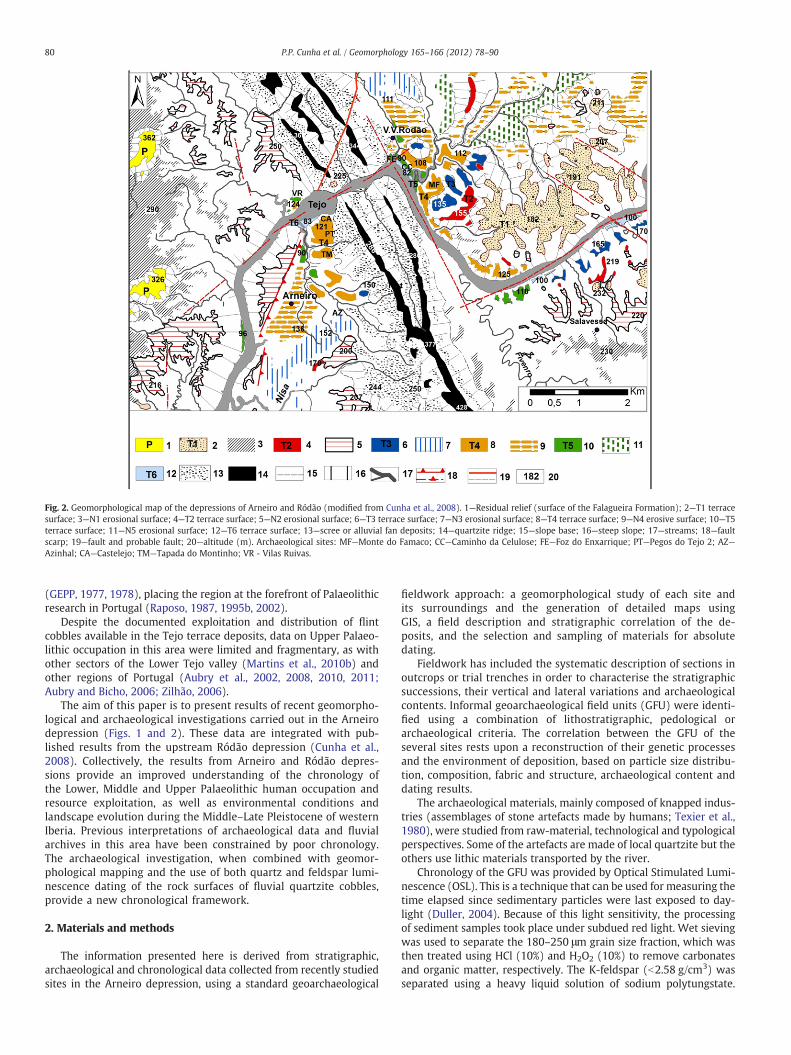
Fig. 2. Geomorphological map of the depressions of Arneiro and Ródão (modified from Cunha et al., 2008). 1—Residual relief (surface of the Falagueira Formation); 2—T1 terracesurface; 3—N1 erosional surface; 4—T2 terrace surface; 5—N2 erosional surface; 6—T3 terrace surface; 7—N3 erosional surface; 8—T4 terrace surface; 9—N4 erosive surface; 10—T5terrace surface; 11—N5 erosional surface; 12—T6 terrace surface; 13—scree or alluvial fan deposits; 14—quartzite ridge; 15—slope base; 16—steep slope; 17—streams; 18—faultscarp; 19—fault and probable fault; 20—altitude (m). Archaeological sites: MF—Monte do Famaco; CC—Caminho da Celulose; FE—Foz do Enxarrique; PT—Pegos do Tejo 2; AZ—Azinhal; CA—Castelejo; TM—Tapada do Montinho; VR - Vilas Ruivas.
80 P.P. Cunha et al. / Geomorphology 165–166 (2012) 78–90
(GEPP, 1977, 1978), placing the region at the forefront of Palaeolithicresearch in Portugal (Raposo, 1987, 1995b, 2002).
Despite the documented exploitation and distribution of flintcobbles available in the Tejo terrace deposits, data on Upper Palaeo-lithic occupation in this area were limited and fragmentary, as withother sectors of the Lower Tejo valley (Martins et al., 2010b) andother regions of Portugal (Aubry et al., 2002, 2008, 2010, 2011;Aubry and Bicho, 2006; Zilhão, 2006).
The aim of this paper is to present results of recent geomorpho-logical and archaeological investigations carried out in the Arneirodepression (Figs. 1 and 2). These data are integrated with pub-lished results from the upstream Ródão depression (Cunha et al.,2008). Collectively, the results from Arneiro and Ródão depres-sions provide an improved understanding of the chronology ofthe Lower, Middle and Upper Palaeolithic human occupation andresource exploitation, as well as environmental conditions andlandscape evolution during the Middle–Late Pleistocene of westernIberia. Previous interpretations of archaeological data and fluvialarchives in this area have been constrained by poor chronology.The archaeological investigation, when combined with geomor-phological mapping and the use of both quartz and feldspar lumi-nescence dating of the rock surfaces of fluvial quartzite cobbles,provide a new chronological framework.
2. Materials and methods
The information presented here is derived from stratigraphic,archaeological and chronological data collected from recently studiedsites in the Arneiro depression, using a standard geoarchaeological
fieldwork approach: a geomorphological study of each site andits surroundings and the generation of detailed maps usingGIS, a field description and stratigraphic correlation of the de-posits, and the selection and sampling of materials for absolutedating.
Fieldwork has included the systematic description of sections inoutcrops or trial trenches in order to characterise the stratigraphicsuccessions, their vertical and lateral variations and archaeologicalcontents. Informal geoarchaeological field units (GFU) were identi-fied using a combination of lithostratigraphic, pedological orarchaeological criteria. The correlation between the GFU of theseveral sites rests upon a reconstruction of their genetic processesand the environment of deposition, based on particle size distribu-tion, composition, fabric and structure, archaeological content anddating results.
The archaeological materials, mainly composed of knapped indus-tries (assemblages of stone artefacts made by humans; Texier et al.,1980), were studied from raw-material, technological and typologicalperspectives. Some of the artefacts are made of local quartzite but theothers use lithic materials transported by the river.
Chronology of the GFU was provided by Optical Stimulated Lumi-nescence (OSL). This is a technique that can be used for measuring thetime elapsed since sedimentary particles were last exposed to day-light (Duller, 2004). Because of this light sensitivity, the processingof sediment samples took place under subdued red light. Wet sievingwas used to separate the 180–250 μm grain size fraction, which wasthen treated using HCl (10%) and H2O2 (10%) to remove carbonatesand organic matter, respectively. The K-feldspar (b2.58 g/cm3) wasseparated using a heavy liquid solution of sodium polytungstate.

81P.P. Cunha et al. / Geomorphology 165–166 (2012) 78–90
The outer layer of K-feldspar grains was etched with diluted HF (10%,40 min), to minimise any contribution from external alpha particlesto the dose rate. Finally, HCl (10%) was again used to dissolve anyremaining soluble fluorides. Measurement of the equivalent doses(De) was performed on Risø TL/DA-15 and TL/DA-16 readers. OSLages were derived by dividing the equivalent doses by the totaldose rates. Generally, the major drawback of the most light-sensitive part of the quartz OSL signal is that it saturates at b200 Gy,limiting the age range to b150 ka (Thomsen et al., 2011). In theLower Tejo Basin, because of the relatively high dose rates (3–5 Gy/ka), quartz luminescence was only suitable for the younger samples(less than ~60 ka). As a result, we decided to work with quartz grains(180–250 μm) from all sediment samples and density-separated Krich feldspar grains (180–250 μm) for older samples. Quartz dose es-timates used a standard UV SAR protocol with a 200 °C preheat for10 s, a 180 °C cut heat, and blue stimulation at 125 °C. Feldspar doseestimates used the IRSL at 50 °C protocol described by Cunha et al.(2008). Dose rates were determined using high resolution gammaspectrometry on bulk samples (Murray et al., 1987; Olley et al.,1996), and assuming a K content of 12.5±0.5% in K feldspar. The av-erage dose rate to K-rich grains is 3.4 Gy ka−1 (s=0.5 Gy; n=12),with internal K and Rb contributing 0.84±0.04 Gy ka−1. OSL mea-surements were also made on six quartzite cobbles (~8 cm in diame-ter) of the Tapada do Montinho site (Fig. 3), carried out on bothwhole rock slices (~1.5 mm thick) and separated quartz grains
Fig. 3. Digital Elevation Model of the region, showing the location of the main Palaeolithic siTejo River; Vilas Ruivas and Foz do Enxarrique, on the right margin (green). Other less imp
(63–300 μm) recovered from the outer 1.5 mm surface of the cobbles(Sohbati et al., 2012).
3. Geomorphological setting
The Tejo River is a long-lived system (~3.6 Ma) being an extreme-ly important fluvial record from one of the largest systems of westernEurope. In the most upstream sector of the Lower Tejo River Basin(Reaches I and II defined by Cunha et al., 2005), the river crossestwo quartzite ridges that separate the Ródão (upstream) and Arneiro(downstream) depressions (Figs. 1 and 2). This region was recentlythe focus of several studies that were undertaken to improve the un-derstanding of controls on landscape evolution during the Pleistocene(Cunha et al., 2005, 2008). Six Pleistocene fluvial terraces (T1 to T6,from top to down) form a staircase that is inset into a top basin fillsurface (P) (Fig. 2 and Table 1). At Monte da Charneca, the earlierT2 complex terrace (consisting of two steps; Cunha et al., 2008) isnow subdivided in two distinct levels, labelled as T2 and T3, so theycorrelate by relative height above the river bed with the terrace levelsin the downstream reaches III and IV of the Lower Tejo (Martins et al.,2010b). The fluvial terrace sequence of the Ródão and Arneiro depres-sions comprises: T1 (+111 m); T2 (+83 m); T3 (+61 m); T4(+34 m); T5 (+18 m) and the T6 (+10 m). The river bed is at72 m above sea level (a.s.l.) immediately upstream of the Ródãogorge, named “Portas de Ródão”. Some vertical displacements
tes with dating (squares): Castelejo and Tapada do Montinho, on the left margin of theortant archaeological sites on the left margin are noted (circles).

Table1
Summaryof
keyge
olog
ical,geo
morph
olog
ical
andarch
aeolog
ical
attributes
fortheRó
dão–
Arn
eiro
terracestaircases
(Low
erTe
joRive
rreachI).T
healtitude
ofthecu
lminan
tsurface
ofthesedimen
tary
basin,
erod
edin
thesede
pression
s,was
estimated
taking
inacco
untthepo
sition
inne
arby
places.L
egen
d:a.s.l.—
elev
ationab
ovesealeve
l;a.r.b.—elev
ationab
ovemod
ernrive
rbe
d.
Sedimen
tary
unit
Tipo
logy
andprob
able
age
Thickn
ess
Altitud
eof
theun
itsu
rface
Sedimen
tology
Lithic
indu
stries
insitu
Falagu
eira
form
ation(P
)Cu
lminan
tsedim.u
nit
(Upp
erPlioc.–Lo
wer
Pleistoc
.)~10
m21
0m
a.s.l.(1
38m
?a.r.b.)
-Yellowishto
white
quartz
rich
sand
san
dclast-su
pportedgrav
elsof
quartzite
(ca.
80%)
andwhite
quartz;max
imum
pebb
lesize
(MPS
)=32
cmNot
iden
tified
Mon
tedo
Pinh
alterrace(T1)
Dep
ositiona
lterrace
(MiddlePleistoc
.)13
m18
3m
a.s.l.(1
11m
a.r.b.)
-Massive
clast-su
pportedgrav
el–bo
ulde
rco
nglomerates;po
orto
mod
eratesorting;
-Sub
-rou
nded
toroun
dedclasts
ofqu
artzite(9
0%)an
dqu
artz;MPS
=32
cmNot
iden
tified
Mon
teda
Charne
caup
per
terrace(T2)
Dep
ositiona
lterrace
(MiddlePleistoc
.)~4m
155m
a.s.l.(8
3m
a.r.b.)
-Massive
clast-su
p.grav
el–bo
ulde
rco
ngl.;
poor
sorting;
-Sub
-rou
nded
toroun
dedclasts
ofqu
artzite(8
0%)an
dqu
artz;MPS
=30
cmNot
iden
tified
Mon
teda
Charne
calower
terrace(T3)
Dep
ositiona
lterrace
(MiddlePleistoc
.)~4m
133m
a.s.l.(6
1m
a.r.b.)
-Massive
clast-su
p.grav
el–bo
ulde
rco
ngl.,
with0.5m-thick
coarse
sand
ston
elens
es;po
orsorting;
-Sub
-rou
nded
toroun
dedclasts
ofqu
artzite(7
8%)an
dqu
artz;MPS
=24
cm
Not
iden
tified
Mon
tedo
Famacoterrace(T4)
Dep
ositiona
lterrace
and
strath;34
0?–15
0ka
1.5m
106m
a.s.l.(3
4m
a.r.b.)
-Massive
clast-su
p.grav
el–bo
ulde
rco
ngl.;
poor
sorting;
-Sub
-rou
nded
clasts
ofqu
artzite(7
5%),qu
artz
andrare
slates/m
etag
reyw
acke
s;MPS
=32
cm
Lower
Palaeo
lithic(M
iddleAch
eulia
n)
Cape
lada
Senh
orada
Alaga
daterrace(T5)
Dep
ositiona
lterrace;
136–
75ka
8m
90m
a.s.l.(1
8m
a.r.b.)
-Veryfine
gree
nsand
swithsomepe
doge
niccalcareo
usco
ncretion
s(a
prob
able
cong
lomeratic
base
isno
tex
posed)
.MiddlePa
laeo
lithic(M
ousterian)
Foz
doEn
xarrique
terrace
(T6)
Dep
ositiona
lterrace;
62–32
ka6m
82m
a.s.l.(1
0m
a.r.b.)
-Aba
sal0
.5m-thich
massive
,clast-sup
.bou
lder
cong
lomerates;
-Upp
er5m
ofgree
nsiltsan
dve
ryfine
sand
swithsomecalcareo
usco
ncretion
s;-Sub
-rou
nded
clasts
ofqu
artzitean
dslates/m
etag
reyw
acke
s;MPS
=31
cm;
Late
MiddlePa
laeo
lithic(Late
Mou
sterian)
aeoliansand
sCo
verun
it;32
–12
kab1m
Variable
-Veryfine
mod
eratelysorted
yello
wishsand
sUpp
erPa
laeo
lithican
dNeo
lithic
alluvial
plain
Mod
ernalluvium
0–4m
72m
a.s.l.
-Peb
blyto
boulde
rsand
san
dgrav
els
82 P.P. Cunha et al. / Geomorphology 165–166 (2012) 78–90
affecting terraces were identified; this could be related to some Pleis-tocene activity of the Ponsul fault and other minor faults coincidentwith linear reaches of the Tejo River (Fig. 2; Cunha et al., 2008).
4. Archaeological setting
In the Ródão depression, several archaeological sites have beenexcavated in the three lower terraces of the Tejo River (T4, T5 andT6) and their main characteristics are described below. Quartziteand quartz raw material is abundant in the terraces while flint/chertis very rare.
At the Monte do Famaco site (Fig. 2), thirty-four rolled quartziteartefacts have been found in the 0.5 m-thick boulder gravels of theT4 terrace (local surface at 116 m a.s.l.) and attributed to the earlyMiddle Acheulian (late Lower Palaeolithic) (Raposo and Silva,1985a, b; Raposo, 1987). More recently, other similar artefacts werefound in situ, showing no evidence of later fluvial transport after itsdeposition in the terrace. At the top of the terrace and in nearby col-luvium, ~1500 Middle Acheulian quartzite artefacts comprising bi-faces, cleavers, scrapers, etc., have been collected, some of themwith evidence of wind abrasion but none indicating reworking by flu-vial transport (Raposo, 1987).
At the Ródão and Vilas Ruivas locations the base of T4 was datedby Infrared Stimulated Luminescence (IRSL) to ~280 ka (Cunha etal., 2008). The burial age is now considered to be older. The age dis-crepancy relates to the anomalous fading affecting the OSL signalfrom feldspars (Wintle, 1973; Spooner, 1992) causing age underesti-mation. Despite the correction methods (Huntley and Lamothe, 2001;Lamothe et al., 2003), such corrections can be >30% and are onlyapplicable to the linear (low dose) part of the dose response curve(Huntley and Lamothe, 2001; Lamothe et al., 2003). Thus, thecorrected age of the base of T4 can reach ~300–340 ka (Martins etal., 2010a) and therefore provides some age control for the in situearly Middle Acheulian industries found at the base of T4. The MiddleAcheulian industries collected from the T4 top deposits probably datefrom ca. 180 ka, as they occur before the early technologically MiddlePalaeolithic lithic remains found in situ in a level located 1 m bellowthe T4 terrace surface at the Pegos do Tejo site (Fig. 3), in the Arneirodepression (Almeida et al., 2008).
At the Caminho da Celulose site (Foz do Enxarrique, Figs. 2 and 3),Mousterian artefacts (Middle Palaeolithic industries) were found insitu (GEPP, 1977; L. Raposo, pers. comm.) in the Senhora da Alagadaterrace (T5). From the 2 m of sediments exposed, two IRSL ages of136±10 ka (sample 052204) and 125±7 ka (052247) and a thermo-luminescence (TL) age of 93 +20/−13 ka (sample LTA8) have beenreported (Cunha et al., 2008).
The Foz do Enxarrique site (Figs. 2 and 3), on the T6 terrace, pro-vided evidence of a rich in situ Mousterian industry, comprising~10,000 pieces of quartzite (67%), white quartz (23%) and flint;some of them clearly showing usage of the Levallois technique(Raposo et al., 1985; Raposo and Silva, 1986; Raposo, 1987).
Abundant megafaunal remains (Cervus elaphus, Equus sp., Bosprimigenius, Elephas antiquus and a rhinoceros), other mammals(e.g. fox, hyena and rabbit), birds and fish (Cardoso, 1993; Brugaland Raposo, 1999; Raposo, 1999) were found in a level locatedabove a basal boulder gravel (0 to 0.5 m-thick) and below very finesands and silts. U-Series studies of three teeth gave an age of 33.6±0.5 ka for this level (Raposo, 1995a). The 5.5 m thick bed of veryfine sands and silts was dated by IRSL as 39 ka (base) to 32 ka (nearthe top) (Cunha et al., 2008).
In the Arneiro depression, fourteen Palaeolithic settlements havebeen identified (Fig. 3), three of which have been subjected toarchaeological excavations.
The excavations at the Vilas Ruivas site (GEPP, 1980a, 1980b;Raposo and Silva, 1981, 1982, 1983, 1985c; Raposo, 1987) showedthat the T4 terrace deposits consist of 4 m of compacted reddish

83P.P. Cunha et al. / Geomorphology 165–166 (2012) 78–90
very coarse gravely sands, yielding six rolled Acheulian type artefactsand a non rolled flake at the base, and a 4 m thick upper bed of boul-der gravels; the terrace surface is at 124 m a.s.l. The Vilas Ruivas site(Figs. 2 and 3) also contains a sedimentary record of the Vilas Ruivasstream before its capture, incised into the Tejo T4 terrace (Silva et al.,1981). Raposo (1987) has identified archaeological structures as fire-places with wind screens. The Mousterian industry recovered here, isrepresented by more than 500 pieces, and includes a large numbershowing indications of the Levallois knapping technique. Levallois in-dustries are characterised by the abundance of stone flakes extractedfrom core pebbles. These artefacts were found on a 1 to 0.5 m-thicksilt bed overlying a gravel bed 0.2 to 0.5 cm thick, that provided TLages of 68 ka +35 ka/−26 ka and 51 ka +13 ka/−12 ka (Raposo,1995a). In the same stratigraphic level, Cunha et al. (2008) obtainedcorrected ages of 113±6 ka and 105±5 ka, using IRSL at 50 °C. Atthe surface, a probable Magdalenian (Upper Palaeolithic) flint indus-try was found associated with a thin cover of aeolian sand (Raposo,1987).
The Pegos do Tejo 2 site (Fig. 3), at the top of the T4 terrace and atan altitude of 110 m a.s.l., provided a Levallois core and other mate-rials knapped in local quartzite, including two right angle notchesand a cortical knife (Mousterian industries—Middle Palaeolithic;Almeida et al., 2008). A quartz OSL age of 135±21 ka (GLL code050301) was obtained from the archaeological bed, located 1 mbelow the top of the T4 terrace. However, the report produced bythe Ghent Luminescence Laboratory indicates that the quartz fromthis sample has a natural dose in the region of the growth curveapproaching saturation. So, the 135±21 ka should be considered asa minimum age. The IRSL (K-feldspar) corrected age of 129±8 kaobtained from the top of the T4 terrace at a nearby outcrop (Cunhaet al., 2008) is also a minimum age (the real age could be ~160 ka).At that site, the T4 terrace deposits comprise a 1 m thick basal gravelunit overlain by 12 m of compacted reddish coarse to medium sandsand an uppermost bed of 1 m of colluvium. At 109 m a.s.l., the base ofthe T4 deposits has a disconformable contact with underlying Palaeo-gene sandstones (Cabeço do Infante Formation; Cunha, 1996).
The Azinhal site (Figs. 2 and 3), on an alluvial unit at an altitude of150 m a.s.l., was discovered in 2003 during a survey campaign(Almeida et al., 2008). One of the Palaeolithic artefacts found is a
Fig. 4. For the Enxarrique–Monte do Pinhal terrace staircase (Ródão depression), the ages oTejo alluvial plain (black circles). If we consider the beginning of the incision stage of the Tefans (raña of Sierra Morena Central), dated as ~1.7 Ma (Escudero and Olmo, 1997), in a similthen the age of the T3 terrace surface could be estimated as ~350–450 ka, T2 at ~500–700 kages of the younger terraces.
hand axe linked to the Micoquian (a Middle Palaeolithic culturalvariant). In the same year, an excavation provided a considerablenumber of Mousterian artefacts (denticulate flakes, scrapers and aMicoquian hand axe). A quartz OSL age of 61±2 ka (GLL code050302) was obtained from the archaeological bed (Almeida et al.,2008).
5. Geomorphology of the Arneiro depression
The Arneiro depression is defined by the quartzite ridges to theeast and an exhumed fault scarp in the west (Ponsul fault). Severalgeomorphic elements were identified in the area (Figs. 2 and 3;Table 4) as follows:
a) an alluvial fan at an elevation 234–250 m a.s.l., considered to becorrelative of the T1 rocky terrace at 225 m a.s.l. (+153 m a.r.b.)in the Portas do Ródão gorge;
b) the T2 terrace at 180 m a.s.l. (+108 m) and the correspondent N2erosive surface;
c) the T3 terrace at 180 m a.s.l. (+78 m) and the correlative N3 ero-sive surface;
d) the wide T4 terrace at 120 m a.s.l. (+48 m) and adjacent N4 ero-sive surface;
e) the T5 terrace at 90 m a.s.l. (+18 m);f) the T6 terrace at 82 m a.s.l. (+10 m);g) a 1 m-thick cover unit of aeolian sands, preserved on top of the T4
terrace, with the base at 120 m a.s.l. (Castelejo hill);h) the modern alluvial infill of the Tejo valley (river bed at 72 m a.s.l.).
Based on the geomorphological evidence from the area, the inter-preted pattern is an overall fluvial incision trend punctuated byperiods of strath enlargement (dynamic equilibrium?) and later ter-race aggradation. Incision by the Tejo occurred in distinct phases.Until the deposition of the sediments that constitute the top of theT2 terrace (probably by ~500 to 700 ka; Fig. 4), the Tejo River wasquite large immediately downstream of the Portas do Ródão gorge,as documented by the widespread remains of the fluvial erosive sur-face that corresponds with the T2 strath and low gradient adjacentslopes (N2 at altitudes of 225 to 180 m a.s.l.). During the next fluvialdowncutting episode, leading to the genesis of T3 and the N3 surface,
f the sedimentary top of the T6, T5 and T4 terraces are plotted against height above thejo River (P; black lozenge) coeval with the depositional surface of the Spanish alluvialar geomorphologic position as the culminant sedimentary unit of the Lower Tejo Basin,a and T1 at ~1.0–1.1 Ma (black squares), using an interpolation from the luminescence

Fig. 5. Tapada do Montinho platform, with the location of the excavated area on an aerial photo (upper); cross-section and map of the intervention (middle). Lithic industry fromthe C2 bed (below): 1—Scraper made from an elongated flake with lateral notches; 2—Levallois core in quartzite with a flake still in place; 3—flake in quartzite; 4—faceted buttflakes; 5—Kombewa flake. The excavated squares refer to a local system of coordinates: X (K, L, M and O); Y (37, 38, 39, 40 and 41).
84 P.P. Cunha et al. / Geomorphology 165–166 (2012) 78–90
the Tejo course was superimposed onto the hanging wall of the Pon-sul fault thrust, and continued the exhumation of the fault scarp frombeneath the Tertiary sandstones. At that time, the Nisa stream had itsmouth near its present-day confluence with the Tejo River (no terracedeposits were found at the T3 level between the present Nisa streamand the Arneiro depression). The N3 level in the Arneiro depressionwas presumably created by headwater erosion of the Vale streaminto the weaker Palaeogene sandstones.
During the final incision stage, the Tejo River produced a narrowvalley downstream of the Ponsul fault and the lower terraces at themouth of the Vale stream (respectively T4 at 121 m, T5 at 90 m andT6 at 82 m of altitude a.s.l.).
6. Archaeological study of the new sites
6.1. The Tapada do Montinho site
The Palaeolithic site named Tapada do Montinho (geographicalcoordinates: 39° 37' 44"; −7° 41' 27"; 125 m a.s.l.; Figs. 3 and 5), dis-covered in 2003, is located on the top of an alluvial platform delimitedby two small streams. A large amount of knapped quartzite material,some flint and some quartz, was found here over an area of 25,000 m2
(Almeida et al., 2008).In 2008, an excavation was carried out in order to verify the exis-
tence of Palaeolithic artefacts in situ. The site was divided in three

Table2
Summaryof
thesedimen
tary
characteristics,luminescenc
eda
ting
resu
ltsan
dlithicindu
stries
oftheTa
pada
doMon
tinh
osite.
Fieldco
de/N
LLco
deof
OSL
sample
Stratigrap
hicallev
elSe
dimen
tary
facies
Burial
depth
Equiva
lent
dose
(De)
Doserate
(Gy/
ka)
Luminescenc
eag
e(ka)
Prob
able
depo
sition
alag
eLithic
indu
stries
TPM-1/
1088
03(C
1un
it)Su
rficial
alluvial
sand
,20cm
-thick
Coarse
white
sand
rich
inqu
artz.
Disturban
ceby
agricu
lture.
15cm
OSL
onqu
artz
grains
250–
180μm
1.33
±0.24
Gy
3.07
±0.05
0.43
±0.08
(n=
21)
b30
to3ka
Reworke
dNeo
lithic,
Upp
eran
dMiddle
Palaeo
lithicartefacts
TPM-2M/
1088
01(C
2un
it)Grave
lbed
,10
cm-thick
Heterom
etricgrav
elof
quartzite
andmilk
yqu
artz
cobb
lesan
dbo
ulde
rs,inagrey
–brow
nco
arse
quartz
sand
matrix
25cm
OSL
onqu
artz
grains
250–
180μm
11.2±
1.4Gy
2.85
±0.13
4.4±
0.5(n
=6)
~62
–32
kaMiddlePa
laeo
lithicartefacts
(som
eof
which
arerolle
d;2bu
rned
clasts
TPM-2/
1099
01-03
1099
01-04
1099
01-05
1099
01-06
1099
01-07
(C2un
it)Grave
lbed
,10
cm-thick
,Heterom
etricgrav
elof
quartzite
andmilk
yqu
artz
cobb
lesan
dbo
ulde
rs,w
ithamatrixof
coarse
quartz
yello
wsand
25cm
OSL
onqu
artz
250–
180μm
extractedfrom
five
quartzite
cobb
les19
–44
Gy
~1.9
14–45
ka~62
–32
kaidem
TPM-3/108
802
(C3un
it)
Yello
wishco
arse
pebb
lyco
mpa
ctsand
55cm
IRSL
50°C
K-felds
pargrains
250–
180μm
204±
16Gy
5.20
±0.21
51±
5(n
=9)
?Not
iden
tified
85P.P. Cunha et al. / Geomorphology 165–166 (2012) 78–90
sectors. Four survey pits of 1 m2 were excavated in the first and sec-ond sectors (Fig. 5). A layer with well-preserved in situ MiddlePalaeolithic industry was found. The spatial distribution and distanceof refitted tool-stones (a technique that involves reconstructing thesequence of flake removal during the knapping activity), confirmsthat the archaeological materials suffered no or little disturbanceafter the discard by prehistoric human groups.
In 2009, a second campaign was undertaken with the objective ofenlarging the excavated area and sampling for luminescence dating.Stratigraphic, sedimentary and archaeological records were describedand studied in detail.
The topmost sedimentary unit (C1), 20 cm thick, is composed ofcoarse sand, mainly of quartz, with some organic material(Table 2). Some lithic remains were recovered and on the basisof their morphological and typological analysis, were assigned tothe Neolithic, Upper Palaeolithic and Middle Palaeolithic. Thedepositional age of the C1 unit is not available because the quartzOSL values obtained from the sediment sample were unexpectedlysmall and highly scattered, probably due to reworking by recentagricultural activity.
Unit C2, 10–15 cm-thick, is a gravelly bed with angular to sub-rounded quartzite cobbles in a pebbly sandy grey–brown matrix. Itcontains a rich industry (~100 pieces/m2), providing an olderLevallois edge and surface rounded flake industry (that were trans-ported from a nearby location), and a more recent industry,characterised by fresh, opportunistic pebble edge knapping, indig-enous to its geological context. Detailed observation of this collec-tion allows the identification of two refitting sequences and a caseof three elongated flakes that do not refit but, due to the colourand texture of the raw material, probably come from the sameknapping sequence. In these three cases, two refitting sequencescome from flakes registered in the same square metre (L40 square,flakes 75 and 144; M40 square: flakes 4, 40 and 59). The otherrefitting was found between two fragments of the same flakethat were located 5 m apart (quadrants N37 and M41). In thiscase, one of the fragments presents some macroscopic evidencefor usage from wear marks. In the rounded Levallois industry norefittings were achieved. The industry used quartzite (82%), flint(11%) and quartz (6%); the quality of the local fine-grained quartz-ite explaining the predominance of this raw material in the assem-blage. The quality of the quartzite is sufficient to allow theapplication of Levallois knapping reduction and this has also beendetected at other Portuguese sites, such as the Oliveira cave (atthe Estremenho Massif) (Marks et al., 2001; Zilhão, 2006).Quartzite is also the preferred raw material in the nearby MiddlePalaeolithic sites of Vilas Ruivas and Foz do Enxarique (Raposo,1995a). In the lithic industry (Fig. 5), we identified cores,Kombewa flakes, some faceted-butt flakes and scrapers, somewith lateral notches (probably for hafting). Levallois flakes arealso present.
Technologically, the C2 assemblage can be assigned to two differ-ent phases of the Middle Palaeolithic. The older rounded Levalloisindustry is characterised by scrapers made from bigger flakes. Themore recent Middle Palaeolithic industry is characterised by smallproducts; this industry is obtained from an opportunistic pebble-edge knapping of the core. The analysis of the refitting pieces and ofthe remainder of the collection has resulted in the identification oftwo types of knapping strategy. The objective of the first was toobtain short but very large flakes, whereas the second aimed forelongated flakes. The Kombewa flakes recovered from the Tapadado Montinho site have bigger dimensions than the rest of the flakesand cores in the assemblage. This could mean that they were alreadyknapped when brought to the site. Two burned clasts were alsofound, suggesting the existence of a campfire.
Luminescence dating based on rock slices (Sohbati et al., 2012)suggest that one cobble surface, and the inner parts of two other

Fig. 6. Stratigraphic section at Castelejo (C.0, C.1, C.2, C.3 and C.4 are the labels for thefive stratigraphic layers), with the location of the four OSL samples, the twoarchaeological levels, the cobble pavement, the fragment of an Upper Palaeolithicbacked bladelet (lower left; collected from a level in the upper part of the C.2 layer)and the Middle Palaeolithic core found during the excavation (lower right).
86 P.P. Cunha et al. / Geomorphology 165–166 (2012) 78–90
cobbles experienced a resetting event at ~45 ka (the probable burialage), consistent with the minimum age of ~32 ka expected for theMousterian industry in this region. However, the surfaces of theother cobbles all record light exposure events in the range 26 to14 ka, suggesting that some of the cobbles were exposed to daylightperhaps more than once in this period. The younger age obtainedfor the sandy matrix could also result from exposure to daylight
Table 3Summary of the sedimentary characteristics, luminescence dating results (OSL on 250–180
Field code/NLL codeof OSL sample
Stratigraphical level Sedimentary facies
– C0 bed surficial aeolian sand withorganic matter, 20 cm-thick
Fine white quartz sand.Disturbance by agricultural wo
CAST1 PC5226 C1 bed aeolian sand, 10 cm-thick Fine white quartz sand.
C2 bed uppermost part Archaeological level AL1CAST2 PC5227 C2 bed aeolian sand, 10 cm-thick Fine white quartz sand
CAST3 PC5228 C2 bed aeolian sand, 10 cm-thick Fine white quartz sand.
C2 bed (lowermost part) Archaeological level AL2CAST4 PC5229 C3 bed Aeolian sand, 20 cm-thick Fine white quartz sand
C4 bed, ~5 cm-thick Pavement of rounded cobles ansome artefacts
C5 bed, T4 terrace, ~14 m-thick Reddish very coarse sands andcobble to boulder gravels
after deposition, possibly by agricultural activity (the layer is only35 cm from the present day surface).
The C3 bed, >20 cm thick, consists of a yellowish coarse sand withsmall rolled pebbles and is archaeologically sterile. Luminescencedating provided an age of 51±5 ka (K-feldspar IRSL signal at 50 °C).
6.2. The Castelejo site
The Castelejo site is located close to the Tejo River (geographicalcoordinates: 39° 38' 270 15"; −7° 41' 22"; 121 m) (Figs. 2 and 3)and corresponds to a remnant of the T4 terrace, with a 1 m-thickcover of aeolian sands. It is located in the central area of a Romangold mine covering ~1 km2, which involved the processing of roughly1060 m³ of the T4 terrace (Deprez et al., 2009). The piles of boulders(spoil), left by the Romans in this type of exploitation, is known in theregion as “Conhal”.
A survey pit (1 m2) was opened in the centre of the uppermostlevel of the Castelejo site (Fig. 6) and four samples for OSL datingwere taken (Table 3). The 20 cm-thick uppermost bed (Bed C0;Fig. 6), comprises fine aeolian quartz sand with organic material,and shows evidence of agricultural activity. The bed C1, 10 cm-thick, consists of fine aeolian sand in which the OSL sample CAST1(3.2±0.2 ka) was collected. Some recent Prehistoric artefacts werefound in this deposit, including a manual millstone and ceramics.The bed C2, ~40 cm thick, consists of fine aeolian sand in which theOSL samples CAST2 (12.0±0.7 ka) and CAST3 (17.1±0.9 ka) werecollected from the top and base, between the archaeological levelsAL1 and AL2. The techno-typological analysis of the industry fromthese two archaeological levels was inconclusive, due to the limitednumber of pieces found. One fragment of a bladelet, a typical UpperPalaeolithic tool, was found in layer C2 (Fig. 6), located between theOSL samples CAST2 and CAST3. The ~20 cm thick bed C3 consists offine aeolian sand, from which the OSL sample CAST4 (32.4±2.4 ka)was collected. The bed C4 is a conglomeratic pavement of roundedcobbles, from which a Middle Palaeolithic core was collected.
The bed C5 corresponds with the deposits of the T4 terrace, herereaching a thickness of 12 m and comprising reddish cobble to boul-der gravels (MPS=40 cm). The base is a disconformity (at109 m a.s.l.) developed into Palaeogene sandstone bedrock.
7. Discussion
In the Lower Tejo, the dated Lower, Middle and Upper Palaeolithicopen air occupations and their associated sedimentary contexts, rep-resent advances in the knowledge about these periods in the IberianPeninsula. When a better chronostratigraphic framework is available
μm quartz grains) and lithic industries of the Castelejo site.
Burial depth(cm)
Dose (Gy) Dose rate(Gy/ka)
Lumin.age (ka)
Probableage (ka)
Lithic industries
rks.– – – – – –
20 16.3±1.0(n=24)
5.08±0.23
3.2±0.2
Neolithic artefactsand ceramics
1235 60±2
(n=27)5.01±0.22
12.0±0.7
Upper Palaeolithic
50 86±2(n=24)
5.03±0.22
17.1±0.9
18–2875 161±9
(n=24)4.95±0.22
32.4±2.4 ka
d ~60–30 MiddlePalaeolithic
>140 –

Table 4Summary of key geological, geomorphological and archaeological attributes for the culminant sedimentary unit and terrace sequences represented at the reaches I to IVa of th ower Tejo River (Ródão to Chamusca) and some tributaries,with indication of flights and probable ages. Local terrace codes were replaced by the ones recognised at the Lower Tejo basin scale. The elevation (m) of each surface, above e modern alluvial plain or river bed, is indicated.
Cunha et al. (2008)Ródão depressionLower Tejo reach I
(This work)Arneiro depressionLower Tejo reach I
Martins et al. (2009)Gavião-Chamusca areaLower Tejo reaches III–IVa
Martins et al. (2010a, 2010b)V.N.B. – Sta. Cita area Ponteda Pedra stream and Bezelga–Nabão sy m
Summary of the lithic industries in the reaches I–IV ofthe lower Tejo basin
Falagueira formation (P) not dated(Pliocene–Lower Pleistocene?)+138 m ?
Falagueira formation (P) not dated(upper Pliocene–Lower Pleistocene?)+218 m ?
Almeirim and Ulme formations not dated(Pliocene to Lower Pleistocene?)+174–210 m
Almeirim formation not dated(Pliocene to Lower Pleistocene?)+162 m
Not found
Monte do Pinhal terrace (T1) not dated(Pleistocene)+111 m
Alluvial fan and rocky terrace on thequartzites of the Portas do Ródão gorge(N1)+153 m
Terrace T1 not dated(Pleistocene)+84–164 m
Terrace T1 not dated(Lower–Middle Pleistocene?)+124 m
Not found
Monte da Charneca upper terrace (T2)not dated(Pleistocene)+83 m
N2 erosive surface and the T2 terrace+108 m
Terrace T2 not dated(Pleistocene)+57–112 m
Terrace T2 not dated(Middle Pleistocene)+92 m
Not found
Monte da Charneca upper terrace (T3)not dated (Pleistocene)+61 m
N3 erosive surface and the T3 terrace+78 m
Pego terrace (T3) (minimal ages)(Middle Pleistocene)+43–73 m
Terrace T3 (minimal ages)(Middle Pleistocene)+57 m
Not found
Monte do Famaco terrace (T4) the topis >135 ka (probably 160 ka); the baseis >280 ka (probably 340 ka);(late Middle Pleistocene)+34 m
Arneiro terrace (T4) the top is >135 ka(probably 160 ka); the base is >280 ka(probably 340 ka);(late Middle Pleistocene)+48 m
Atalaia terrace (T4) >220 to ~160 ka(late Middle Pleistoc.)+26–63 m
Atalaia terrace (T4) >190to 160 ka(late Middle Pleistoc.)+37 m
Lower Palaeolithic (lower-late Acheulian) MonteFamaco, Vale do Forno, Fonte da Moita, Rib. Ponte daPedra—early Middle Palaeolithic at the topmost; Pegosdo Tejo, Vale do Forno 8
Sra. da Alagada terrace (T5) 135 to 73 ka(Upper Pleistocene)+18 m
T5 at +18 m; alluvial sediments atTapada do Montinho (78 ka); fluvialrecord at Vilas Ruivas (palaeo-tributary;113 to 105 ka)
Entroncamento terrace (T5) ~125to 76 ka(Upper Pleistocene)+18–28 m
Entroncamento terrace(T5) ~125 to 90 ka(Upper Pleistocene)+16 m
Middle Palaeolithic (Mousterian) Sra. Alagada chapel,Vilas Ruivas silt bed, Rib. Ponte da Pedra, Sto. Antão doTojal
Foz do Enxarrique terrace (T6) 39 to 32 ka(uppermost Pleist.)+10 m
T6 terrace (62 to 32 ka) at +10 m andalluvial sediments (Tapada do Montinho)(uppermost Pleist.)
Golegã terrace (T6) 55 to 51 ka(uppermost Pleistoc.)+0–10 m
Golegã terrace (T6) ~62to ~30 ka (uppermost Pleist.)+7 m
Late Middle Palaeolithic (late Mousterian) FozEnxarique, Tapada do Montinho, Conceição, Santa Cita
Colluvium and aeolian sands (these notpreserved);(uppermost Pleistocene)
Colluvium and aeolian sands 32 to 12 ka;(uppermost Pleistocene)
Colluvium and Carregueira Sands(aeolian sands climbing on the SE slopes)(uppermost Pleistoc.)
Colluvium and fine-grainedaeolian sands deposited onthe valley slopes ~30 to ?12 ka;(uppermost Pleistoc.)
Upper Palaeolithic to Epipalaeolithic Tapada doMontinho Rib. Ponte da Pedra, Santa Cita
Valley fill deposits underlying the presentfloodplain+2 m (Holocene)
Valley fill deposits and local aeoliansands (~4–0 ka)(Holocene)
Valley fill deposits underlying thepresent floodplain(Holocene)
Valley fill deposits and localaeolian dunes rising above thealluvial plain; ~12–0 ka;(uppermost Pleistoc. to Holocene)
Mesolithic and more recent industries(several sites)
87P.P.Cunha
etal./
Geom
orphology165
–166(2012)
78–90
e Lth
ste

88 P.P. Cunha et al. / Geomorphology 165–166 (2012) 78–90
for all of Europe, the comparison of the Portuguese Tejo River recordswith records of fluvial evolution and human occupation and migra-tion in Spain (e.g. Santisteban and Schulte, 2007) and nearbyEuropean systems (Bridgland et al., 2006, 2007; Westaway et al.,2009) will be very important.
In the Ródão and Arneiro depressions, and in the downstreamreaches of the Lower Tejo River, the T4 terrace contains Lower Palaeo-lithic industries (supposedly lower to late Acheulian; see alsoOosterbeck et al., 2010; Table 4). In the Lower Tejo River, MiddlePalaeolithic industries were identified in the topmost part of T4(replacing the Acheulian industries probably at ~160 ka), but also as-sociated with T5 (Vilas Ruivas and Sto. Antão do Tojal sites) and T6(Foz do Enxarrique and Conceição sites) (Raposo, 1986, 2000, 2002).
The Middle Palaeolithic industries represent a change, both withrespect to occupation patterns and typological characterization ofthe industry. Fairly complex living structures (fireplaces with windscreens, etc.) were constructed (e.g. at Vilas Ruivas) and the Levalloismethod was used widely, with an almost complete abandonment ofprevious large instruments (hand axes, cleavers, scrapers, etc.).
The Upper Palaeolithic is not well documented in Reach I of theLower Tejo (Table 4). The artefacts that have been discovered so farin river terrace deposits cannot be clearly linked to the initial phasesof this cultural period. Due to this, studies in the aeolian sand deposits(supposedly bracketing the Upper Palaeolithic) are important andshould be further developed in future work in conjunction with OSLdating to provide an accurate age control.
In the western Iberia offshore region, during the period 57 to31 ka, climate was characterised by a succession of mild and wet pe-riods (interstadials) alternating with cold and dry periods (stadials),related to the Dansgaard–Oescheger (D–O) cycles (Lebreiro et al.,1996; De Abreu et al., 2003; Roucoux et al., 2005). A succession ofD–O cycles also occurred after 31 ka; however, in the 57 to 31 ka pe-riod ten D–O insterstadials occurred, while in the last 31 ka only fouroccurred. The Lower Tejo T6 terrace, poor in clay matrix and rangingin age ~62 to 32 ka, is the sedimentary record located onshore ofthese mild-cold and wet climate conditions.
The climate conditions were particularly severe during theHeinrich events (He) (Heinrich, 1988), of which there were threeafter 31 ka: at 30.2–29.0 ka (He3), 24.3–23.1 ka (He2) and17.6–14.9 ka (He1) (Lebreiro et al., 1996). Pollen data indicate a dom-inance of open herbaceous vegetation, with increased areas of steppein the period 31–23 ka (Roucoux et al., 2005). In the western part ofIberia, the mean temperature of the coldest month could have rangedbetween 0 °C and−6 °C during the Heinrich events (He), from−2 °Cto 2 °C during the D–O stadials, whilst it is 5 °C in the present day(Sánchez Goñi et al., 2002). The annual rainfall values could havereached 400 mm during the Heinrich events; 500 mm in the D–O sta-dials, while in the present day are 800 mm (Sánchez Goñi et al.,2002). In the study area and adjacent reaches of the Lower Tejo val-ley, these cold-dry climate conditions would have modified the flowregime of the river, with limited fluvial sediment transport and lowflow conditions. This is most marked when a change from fluvial toaeolian sedimentation occurred at ~32 ka. This environmental changecoincides with the disappearance of the Megafauna and associatedNeanderthal communities, as well as the replacement of the MiddlePalaeolithic industries by Upper Palaeolithic ones. This relationshipbetween environmental change and alterations to early human occu-pation and industry styles agrees with dated sedimentary records inother areas of Portugal (Raposo, 2000; Aubry et al., 2011).
The aeolian sands began to be carried from the exposed alluvialplain, by NW winds, just after the time when the Tejo River startedto cut down, at 32 ka. The OSL ages of the aeolian sand unit indicatestwo main phases of aeolian activity:
i) one from 32 to 12 ka, containing Upper Palaeolithic industriesand corresponding to the last Pleniglacial (28–13.5 ka); this
coincides with the onset of a severe cold and dry climate inthe North Atlantic (Roucoux et al., 2005);
(ii) a later phase at ~3 ka (only one date); this agrees with the “Coldperiod 1”, dated 1000 to 250 yr cal BC (Sánchez Goñi, 2006),with the colder climate conditions during the Iron Age Epoch(900 to 300 yr BC) recorded in northeastern Spain (Gutiérrez-Elorza and Peña-Monné, 1998), or with the classical Sub-Boreal climatic period (temperate dry conditions; 5 to 2 ka).
During 32 to 12 ka, the offshore climate conditions were more se-vere (colder and drier) than in the period 57 to 32 ka. This could ex-plain why the coeval archaeological remains were found mainly incaves and are rare in fluvial and aeolian sedimentary deposits. TheArneiro depression probably gave some sheltered conditions againstthe strong and cold winds but also provided resources associated tothe Tejo River (food, water and raw materials).
8. Conclusions
This study, focused on the Arneiro depression, provides a geomor-phological characterization and interpretation of the landscape evolu-tion of the River Tejo in its most upstream Portuguese reach. It hasenabled an improved understanding of the chronology of the threelower terraces and also provides some constraint for the ages of theupper terrace surfaces, for which absolute dating was previouslyunavailable:
Terrace T1—top at ~1.0–1.1 MaTerrace T2—top at ~500–700 kaTerrace T3—top at ~350–450 kaTerrace T4—~340 to ~160 kaTerrace T5—136 to 75 kaTerrace T6—62 to 32 ka.
In Reaches I–IV of the Lower Tejo, the oldest artefacts were foundin the T4 terrace base. This indicates that the probable age for the old-est human occupation found so far in Portugal is ca. 340 ka.
New data have been collected in the Tapada do Montinho andCastelejo sites, containing Middle Palaeolithic to Upper Palaeolithicindustries preserved in situ on the dated sedimentary successions.These data provide new insights into the geomorphological context,sedimentary forcing and chronology associated with human occupa-tion during the Late Pleistocene in western Iberia. More specifically,the research provides new data concerning human activity in thisarea under the cold climate conditions of the last 62 to 12 ka, includ-ing the very dry conditions from 32 to 12 ka; the latter period has im-portant implications for aeolian dynamics within river valley settings.
Absolute dating was provided by luminescence methods, usingsedimentary quartz and K-feldspar (the latter was the only availablemethod when the quartz OSL signal reached saturation) and therock surface of quartzite cobbles. The OSL dating from surface cobblesis a promising method for dating geological and archaeologicalmaterials.
Integration of the available archaeological data indicate thatAcheulian industries (Lower Palaeolithic) were replaced by theMiddle Palaeolithic ones at ~160 ka, and that these in turn werereplaced by Upper Palaeolithic industries at 32 ka; the coeval markedenvironmental changes could be responsible for the disappearance ofthe Megafauna and associated Neanderthal communities. This workalso provides the first identification of dated Upper Palaeolithicindustries in this upstream reach of the Lower Tejo River. Therelationship of the Upper Palaeolithic industries with aeolian sedi-ments demonstrates some presence of human activity in valley floorfloodplain areas (possibly more sheltered locations) and a periodwhen the climate was cold and dry. Normally, evidence for human
89P.P. Cunha et al. / Geomorphology 165–166 (2012) 78–90
activity during this time period appears to be associated with cavesites that are fully protected from prevailing winds.
Acknowledgements
This work is part of the activities of the projects PHANA and PTDC/CTE-GIN/66283/2006, approved by the Fundação para a Ciência e aTecnologia and co-founded by the FEDER. The Nisa town hall isthanked for the financial support to the archaeological excavation(N. Almeida) and OSL dating. Research also has been supported bythe IMAR-CMA Univ. Coimbra, Centro de Geofísica – Univ. Évora(Portugal), and both Aarhus University and Risø DTU (Denmark).Martin Stokes (Univ. Plymouth), D.R. Bridgland (Durham University)and an anonymous reviewer are thanked for their very thorough andconstructive reviews.
References
Almeida, N., Deprez, S., De Dapper, M., 2008. The Palaeolithic occupation of the North-eastern of Alen Tagus (Portugal): a geoarchaeological approach. In: Bueno-Ramirez, P., Barroso-Bermejo, R., Balbín Berhmann, R. (Eds.), Graphical Markersand Megalith Builders in the International Tagus, Iberian Peninsula: British Archae-ological Reports International Series, 1765, pp. 19–26.
Aubry, T., Bicho, N.F., 2006. Le Paléolithique supérieur du Portugal. In: Noiret, P. (Ed.),Le Paléolithique supérieur européen. Bilan quinquennal 2001–2006. UISPP, Liège,pp. 135–145 (ERAUL 115).
Aubry, T., Mangado Llach, X., Sellami, F., Sampaio, J.D., 2002. Open-air Rock-art. Terri-tories and modes of exploitation during the Upper Paleolithic in the Côa Valley(Portugal). Antiquity 76 (291), 62–76.
Aubry, T., Almeida, M., Dimuccio, L., Gameiro, C., Neves, M.-J., Klaric, L., 2008. Caractér-isation et discontinuités des registres pédo-sédimentaires de l'occident péninsu-laire entre 30.000 et 10.000 BP. In: Aubry, T., Almeida, F., Cristina Araújo, A.,Tiffagom, M. (Eds.), BAR S1831 2008: Proceedings of the XV World CongressUISPP (Lisbon, 4–9 September 2006), Vol. 21, pp. 9–21. Sessions C64 and C65,.
Aubry, T., Dimuccio, L., Mercè, Bergadà M., Sampaio, J.D., Sellami, F., 2010. Palaeolithicengravings and sedimentary environments in the Côa River Valley (Portugal): im-plications for the detection, interpretation and dating of open-air rock art. Journalof Archaeological Science 37, 3306–3319.
Aubry, T., Dimuccio, L.A., Almeida, M., Neves, M.J., Angelucci, D., Cunha, L., 2011.Palaeoenvironmental forcing during the Middle–Upper Palaeolithic transition inCentral-western Portugal. Quaternary Research 75, 66–79.
Benito Calvo, A., Pérez-González, A., Santonja, M., 1998. Terrazas rocosas, aluviales ytravertínicas del valle alto del río Henares (Guadalajara, España). Geogaceta 24,55–58.
Benito, G., Sopeña, A., Sánchez-Moya, Y., Machado, M.J., Pérez-González, A., 2003.Palaeoflood record of the Tagus River (Central Spain) during the Late Pleistoceneand Holocene. Quaternary Science Reviews 22, 1737–1756.
Bridgland, D., Antoine, P., Limondin-Lozouet, N., Santisteban, J., Westaway, R., White,M., 2006. The Palaeolithic occupation of Europe as revealed by evidence from therivers: data from IGCP 449. Journal of Quaternary Science 21, 437–455.
Bridgland, D.R., Keen, D.H., Westaway, R., 2007. Global correlation of Late Cenozoic flu-vial deposits: a synthesis of data from IGCP 449. Quaternary Science Reviews 26,2694–2700.
Brugal, J., Raposo, L., 1999. The role of the Early Humans in the accumulation of Euro-pean Lower and Middle Palaeolithic bone assemblages. Monographien desRömisch-Germanischen Zentralmuseums 42, 367–378.
Cardoso, J.L., 1993. Contribuição para o conhecimento dos grandes mamíferos do Plis-tocénico Superior de Portugal. Camara Municipal de Oeiras, Oeiras. 567 pp.
Cunha, P.P., 1996. Unidades litostratigráficas do Terciário da Beira Baixa (Portugal).Comunicaçōes do Instituto Geológico e Mineiro 82, 87–130.
Cunha, P.P., Martins, A.A., Daveau, S., Friend, P.F., 2005. Tectonic control of the Tejoriver fluvial incision during the late Cenozoic, in Ródão – central Portugal (AtlanticIberian border). Geomorphology 64, 271–298.
Cunha, P.P., Martins, A.A., Huot, S., Murray, A.S., Raposo, L., 2008. Dating the Tejo Riverlower terraces in the Ródão area (Portugal) to assess the role of tectonics and up-lift. Geomorphology 102, 43–54.
De Abreu, L., Shackleton, N.J., Schönfeld, J., Hall, M., Chapman, M.R., 2003. Millennial-scale oceanic climate variability off the Western Iberian margin during the lasttwo glacial periods. Marine Geology 196, 1–20.
De Vicente, G., Cloetingh, S., Van Wees, J., Cunha, P.P., 2011. Tectonic classification ofCenozoic Iberian foreland basins. Tectonophysics 502 (1–2), 38–61.
Deprez, S., De Dapper, M., Almeida, N., De Paepe, P., Vermeulen, F., 2009. A geoarchaeo-logical study of the historical placer gold exploitation of the Tagus River terrace ofthe Conhal (Nisa, Northeastern Alentejo, Portugal). In: De Dapper, M., Vermeulen,F. (Eds.), “Ol'Man River”: Geo-archaeological Aspects of Rivers and River Plains.Proceedings of the International Colloquium, Ghent, 22–24 September 2006.Archaeological Reports Ghent University, pp. 311–332.
Duller, G.A.T., 2004. Luminescence dating of Quaternary sediments: recent advances.Journal of Quaternary Science 19, 183–192.
Escudero, B., Olmo, D., 1997. Resultados paleomagnéticos de la raña del Hespérico Me-ridional (Montoro, Córdoba). Geogaceta 21, 31–34.
GEPP, 1977. O Paleolítico. As primeiras comunidades humanas de caçadores recolec-tores. Grupo para o Estudo do Paleolítico Português. Edição do Museu FranciscoTavares Proença Júnior, Castelo Branco.
GEPP, 1978. O Paleolítico de Ródão. Aspectos e Métodos da Pré-História, 1. Trabalhosdo GEAP, Lisboa, pp. 71–77.
GEPP, 1980a. Um acampamento do Homem de Neandertal nas margens do Tejo? His-toria 15, 38–43.
GEPP, 1980b. Vilas Ruivas: um acampamento do Paleolítico Médio. História e Sociedade7, 29–33.
Gutiérrez-Elorza, M., Peña-Monné, J.L., 1998. Geomorphology and late Holocene cli-matic change in Northeastern Spain. Geomorphology 23, 205–217.
Heinrich, H., 1988. Origin and consequences of cyclic icerafting in the Northeast Atlan-tic ocean during the past 130,000 years. Quaternary Research 29, 142–152.
Huntley, D.J., Lamothe, M., 2001. Ubiquity of anomalous fading in K-feldspars and themeasurement and correction for it in optical dating. Canadian Journal of Earth Sci-ences 38, 1093–1106.
Lamothe, M., Auclair, M., Hamzaoui, C., Huot, S., 2003. Towards a prediction of long-term anomalous fading of feldspar IRSL. Radiation Measurements 37, 493–498.
Lebreiro, S.M., Moreno, J.C., McCave, I.N., Weaver, P.P.E., 1996. Evidence for the Hein-rich layers off Portugal (Tore Seamount: 391N, 121W). Marine Geology 131,47–56.
Marks, A., Monigal, K., Zilhão, J., 2001. The lithic assemblages of the Late Mousterian atGruta da Oliveira, Almonda, Portugal. In: Zilhão, J., Aubry, T., Carvalho, A.F. (Eds.),Les premiers hommes modernes de la Péninsule Ibérique. Instituto Português deArqueologia, Lisboa, pp. 145–154.
Martins, A.A., Cunha, P.P., Huot, S., Murray, A.S., Buylaert, J.-P., 2009. Geomorphologicalcorrelation of the tectonically displaced Tejo River terraces (Gavião-Chamuscaarea, central Portugal) supported by luminescence dating. Quaternary Internation-al 199, 75–91.
Martins, A.A., Cunha, P.P., Buylaert, J.P., Huot, S., Murray, A.S., Dinis, P., Stokes, M.,2010a. K-feldspar IRSL dating of a Pleistocene river terrace sequence of theLower Tejo River (Portugal, western Iberia). Quaternary Geochronology 5,176–180.
Martins, A.A., Cunha, P.P., Rosina, P., Oosterbeck, L., Cura, S., Grimaldi, S., Gomes, J.,Buylaert, J.-P., Murray, A.S., Matos, J., 2010b. Geoarchaeology of Pleistocene openair sites in the Vila Nova da Barquinha - Santa Cita area (Lower Tejo River basin,central Portugal). Proceedings of the Geologists Association 121, 128–140.
Murray, A.S., Marten, R., Johnston, A., Martin, P., 1987. Analysis for naturally occurringradionuclides at environmental concentrations by gamma spectrometry. Journal ofRadioanalytical and Nuclear Chemistry 115, 263–288.
Olley, J.M., Murray, A.S., Roberts, R.G., 1996. The effects of disequilibria in the uraniumand thorium decay chains on burial dose rates in fluvial sediments. Quaternary Sci-ence Reviews 15, 751–760.
Oosterbeck, L., Grimaldi, S., Rosina, P., Cura, S., Cunha, P.P., Martins, A.A., 2010. The ear-liest Pleistocene archaeological sites in western Iberia: present evidences and re-search prospects. Quaternary International 223–224, 399–407.
Pais, J., Cunha, P.P., Pereira, D., Legoinha, P., Dias, R., Moura, D., Brum da Silveira, A.,Kullberg, J.C., González-Delgado, J.A., 2012. The Paleogene and Neogene of WesternIberia (Portugal). A Cenozoic Record in the European Atlantic Domain. SpringerBriefs in Earth Sciences. 158 pp.
Pérez-González, A., 1994. Depresión del Tajo. In: Gutiérrez Elorza, M. (Ed.), Geomorfo-logía de España. Ed. Rueda, Madrid, pp. 389–436.
Pinilla, L., Pérez-González, A., Sopeña, A., Parés, J.M., 1995. Fenómenos dehundimientos sinsedimentarios en los depósitos cuaternarios del río Tajo enla cuenca de Madrid (Almoguera-Fuentidueña de Tajo). In: Aleixandre, T.,Pérez-González, A. (Eds.), Reconstrucción de paleoambientes y cambios climá-ticos durante el Cuaternario. : Centro de Ciencias Medioambientales, 3. C.S.I.C,Madrid, pp. 125–139.
Raposo, L., 1986. Mustiero-Languedocence ou Languedocense? Arqueologia 14, 13–21.Raposo, L., 1987. Os mais antigos vestígios de ocupação humana Paleolítica na região de
Ródão. Da Pré-história à História – Homenagem a Octávio da Veiga Ferreira.Editorial Delta, pp. 153–178.
Raposo, L., 1995a. Ambientes, territorios y subsistencia en el Paleolitico medio de Por-tugal. Complutum 6, 57–77.
Raposo, L., 1995b. O Paleolítico. In: Medina, J. (Ed.), História de Portugal, vol. 1. ClubeInternacional do Livro, Lisboa, pp. 23–85.
Raposo, L., 1999. Foz do Enxarrique (Ródão, Portugal): preliminary results of the anal-ysis of a bone assemblage from a Middle Palaeolithic open site. In: Gaudzinski, S.,Turner, E. (Eds.), The Role of Early Humans in the Accumulation of EuropeanLower and Middle Palaeolithic Bone Assemblages: Ergebnisse eines Kolloquiums(Romisch-Germanisches Zentralmuseum Forschungsinstitut fur Vor- und Fruh-geschichte Monographien, 42, pp. 367–379.
Raposo, L., 2000. The Middle–Upper Palaeolithic transition in Portugal. In: Stringer, C.,Barton, R., Finlayson, C. (Eds.), Neanderthals on the Edge: 150th Anniversary Con-ference of the Forbes' Quarry Discovery, Gibraltar. Oxbow Books, Oxford, pp.95–109.
Raposo, L., 2002. Um século de estudos no Paleolítico Médio em Portugal: balanço eperspectivas. Arqueologia e História 54, 25–39.
Raposo, L., Silva, A.C., 1981. Elementos de cultura material na estação paleolítica deVilas Ruivas (Ródão). Arqueologia 4, 94–104.
Raposo, L., Silva, A.C., 1982. A campanha 541 de escavações de 1979 em Vilas Ruivas.Informação Arqueológica 2, 43–48.
Raposo, L., Silva, A.C., 1983. A estação Paleolítica de Vilas Ruivas (Ródão) – campanhade 1979. O Arqueólogo Português, Lisboa, 4ª série, vol. 1, pp. 15–38.

90 P.P. Cunha et al. / Geomorphology 165–166 (2012) 78–90
Raposo, L., Silva, A.C., 1985a. A campanha de escavações de 1983 no Monte Famaco.Informação Arqueológica 5, 68–69.
Raposo, L., Silva, A.C., 1985b. A sala de arqueologia do Centro Municipal de Cultura deVila Velha de Ródão. Arqueologia 11, 126–130.
Raposo, L., Silva, A.C., 1985c. A campanha de escavações de 1982 em Vilas Ruivas. Infor-mação Arqueológica 5, 70.
Raposo, L., Silva, A.C., 1986. O estudo do Paleolítico de Ródão síntese dos conhecimen-tos actuais. Trebarvna II, 9–16.
Raposo, L., Silva, A.C., Salvador, M., 1985. Notícia da descoberta da estação Mustierenseda Foz do Enxarrique (Ródão). I Reunião do Quaternário Ibérico, 2, pp. 79–90 (Pro-ceedings), Lisboa.
Roucoux, K.H., de Abreu, L., Shackleton, N.J., Tzedakis, P.C., 2005. The response of NWIberian vegetation to North Atlantic climate oscillations during the last 65 kyr.Quaternary Science Reviews 24, 1637–1653.
Sánchez Goñi, M.F., 2006. Interactions vegetation-climate au cours des derniers 425000ans en Europe occidentale. Le message du pollen des archives marines. Quaternaire17, 3–25.
Sánchez Goñi, M.F., Cacho, I., Turon, J.L., Guiot, J., Sierro, F.J., Peypouquet, J.P., Grimalt,J.O., Shackleton, N.J., 2002. Synchroneity between marine and terrestrial responsesto millennial scale climatic variability during the last glacial period in the Mediter-ranean region. Climate Dynamics 19, 95–105.
Santisteban, J., Schulte, L., 2007. Fluvial networks of the Iberian Peninsula: a chronolog-ical framework. Quaternary Science Reviews 26, 2738–2757.
Santonja, M., Pérez-González, A., 1997. Los yacimientos acheulenses en terrazas flu-viales de la Meseta Central española. In: Rodríguez, V.J. (Ed.), Cuaternario Ibérico,AEQUA, Huelva, Spain, pp. 224–234.
Santonja, M., Pérez-González, A., 2002. El Paleolítico inferior en el interior de la Penín-sula Ibérica. Un punto de vista desde la geoarqueología. Zephyrus 53–54, 27–77.
Silva, A., Pimenta, C., Lemos, F., Zilhão, J., Mateus, J., Raposo, L., Coutinho, M., 1981. VilasRuivas: um acampamento do Paleolítico Médio. Breve história dos trabalhosarqueológicos realizados em Vilas Ruivas. História e Sociedade 7, 29–33.
Silva, P., Palomares, M., Rubio, F., Goy, J., Hoyos, M., Martín-Serrano, A., Zazo, C., Alberdi,M., 1999. Geomorfología, estratigrafía, paleontología y procedencia de los depósi-tos arcósicos cuaternarios de la depresión Prados-Guatén (SW Madrid). Cuater-nario y Geomorfología 13, 79–94.
Sohbati, R., Murray, A., Buylaert, J.-P., Almeida, N., Cunha, P.P., 2012. Optically stimulat-ed luminescence (OSL) dating of quartzite cobbles from the Tapada do Montinhoarchaeological site (east-central Portugal). Boreas 41, 452–462.
Spooner, N.A., 1992. Optical dating: preliminary results on the anomalous fading of lu-minescence from feldspars. Quaternary Science Reviews 11, 139–145.
Texier, J., Inizan, M.L., Roche, H., Dauvois, M., 1980. Préhistoire de la pierre taillé I. Ter-minologie et technologie. Antibes, Cercle de Recherches et d'Etudes Préhistorique.CREP, Nanterre. 120 pp.
Thomsen, K.J., Murray, A.S., Jain, M., 2011. Stability of IRSL signals from sedimentary K-feldspar samples. Geochronometria 38, 1–13.
Westaway, R., Bridgland, D.R., Sinha, R., Demir, T., 2009. Fluvial sequences as evidencefor landscape and climatic evolution in the Late Cenozoic: a synthesis of data fromIGCP 518. Global and Planetary Change 68, 237–253.
Wintle, A.G., 1973. Anomalous fading of thermoluminescence in mineral samples. Na-ture 245, 143–144.
Zilhão, J., 2006. Chronostratigraphy of the Middle-to-Upper Paleolithic Transition inthe Iberian Peninsula. Pyrenae 37, 7–84.