Embed Size (px)
Citation preview

Research paper
−241−Synthesiology - English edition Vol.5 No.4 pp.241-250 (Mar. 2013)
announcing the results to society and contributing in disaster mitigation. How the demand and request from society toward earthquake research changed before and after the earthquake is reviewed, and how AIST should respond to the social demands will be considered.
2 Earthquake evaluation method
Since the 1995 Kobe Earthquake, the Headquarters for Earthquake Research Promotion (hereinafter, will be called Earthquake Headquarters) was established in the Agency of Science and Technology (currently Ministry of Education, Science, Sports, Culture, Science and Technology; MEXT). Under its leadership, earthquake research shifted its direction from scientific research to research that contributes to earthquake disaster prevention. One of the most important projects of the Earthquake Headquarters is the “Long-term Evaluation of Earthquakes.”[1]
Based on the assumption that great earthquakes occur repeatedly in approximately the same place at the same scale, the earthquake that might occur in the future was predicted based on the information of the location, scale, and age of the past earthquakes. In this case, the reliability of the earthquake evaluation increased in accordance to the level of reliability of the information on past earthquakes.
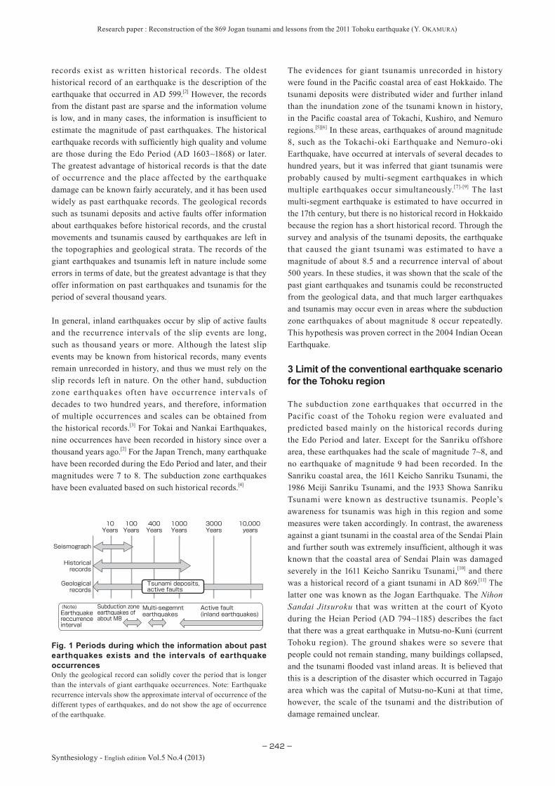
The most accurate record of earthquakes is the record detected by the seismometer, but such information is available only for about a hundred years (Fig. 1). The older
1 Introduction
The ultimate goal of earthquake research is to mitigate the disastrous effects of earthquakes. Since the 1995 Kobe Earthquake (in the news media, Great Hanshin-Awaji Earthquake or Great Hanshin Earthquake), the emphasis of the earthquake research was placed on disaster prevention and mitigation. However, several earthquakes occurred in places where active faults were not recognized after the 1995 earthquake. In adition, effective warnings could not be issued in the 2011 Tohoku-oki Earthquake (in the media, Great East Japan Earthquake). But, our research group has been studying the tsunami generated by the Jogan Earthquake that devastated the Sendai Plain in AD 869. We are regretful that the Tohoku-oki Earthquake occurred before our study results could be reflected in the disaster prevention measures in the region. The difficulty of predicting the natural phenomenon has become very apparent. It is also true that this earthquake illuminated the weaknesses of earthquake research based on geophysics, and instead, shifted the focus to paleoseismology or the study of past ear thquakes based on geology as conducted at AIST.
In this paper, we describe AIST’s research method of reconstructing the Jogan Earthquake and tsunami that occurred in AD 869 by integrating the studies of history, geology, and geophysics. Also, we present the importance and issues of research for estimating the scale of a tsunami from the tsunami deposits that became clear in the 2011 Tohoku-oki Ear thquake, and discuss the problems in
- Significance of ancient earthquake studies and problems in announcing study results to society-
To estimate the magnitude of the 869 Jogan tsunami (described in the historical record), we surveyed tsunami deposits and constructed a source-fault model by combining geological data with geophysical simulation. Although the 2011 Tohoku earthquake was larger than the earthquake estimated by our Jogan model, the 2011 earthquake proved that tsunami deposits are evidence of past giant tsunamis, and reliable warnings of future giant tsunamis. Our study results on the Jogan tsunami were submitted to the Headquarters of Earthquake Research Promotion, and in March 2011, the evaluation was near completion. However, the earthquake occurred just before issuing a warning against a giant tsunami. We need to announce our study of ancient earthquakes and tsunamis to society as quickly as we can so as not to repeat such a tragedy. Moreover, we have to concurrently carry out reliable studies based on rigorous surveys.
Reconstruction of the 869 Jogan tsunami and lessons from the 2011 Tohoku earthquake
Keywords : Jogan earthquake, Tohoku-oki earthquake, tsunami deposits, announcement, disaster mitigation
[Translation from Synthesiology, Vol.5, No.4, p.234-242 (2012)]
Yukinobu Okamura
Active Fault and Earthquake Research Center, AIST 1-1-1 Higashi, Tsukuba 305-8567, Japan E-mail:
Original manuscript received March 1, 2012, Revisions received June 4, 2012, Accepted June 8, 2012
Research paper : Reconstruction of the 869 Jogan tsunami and lessons from the 2011 Tohoku earthquake (Y. Okamura)
−242−Synthesiology - English edition Vol.5 No.4 (2013)
records exist as written historical records. The oldest historical record of an earthquake is the description of the earthquake that occurred in AD 599.[2] However, the records from the distant past are sparse and the information volume is low, and in many cases, the information is insufficient to estimate the magnitude of past earthquakes. The historical earthquake records with sufficiently high quality and volume are those during the Edo Period (AD 1603~1868) or later. The greatest advantage of historical records is that the date of occurrence and the place affected by the earthquake damage can be known fairly accurately, and it has been used widely as past earthquake records. The geological records such as tsunami deposits and active faults offer information about earthquakes before historical records, and the crustal movements and tsunamis caused by earthquakes are left in the topographies and geological strata. The records of the giant earthquakes and tsunamis left in nature include some errors in terms of date, but the greatest advantage is that they offer information on past earthquakes and tsunamis for the period of several thousand years.
In general, inland earthquakes occur by slip of active faults and the recurrence intervals of the slip events are long, such as thousand years or more. Although the latest slip events may be known from historical records, many events remain unrecorded in history, and thus we must rely on the slip records left in nature. On the other hand, subduction zone ear thquakes of ten have occurrence intervals of decades to two hundred years, and therefore, information of multiple occurrences and scales can be obtained from the historical records.[3] For Tokai and Nankai Earthquakes, nine occurrences have been recorded in history since over a thousand years ago.[2] For the Japan Trench, many earthquake have been recorded during the Edo Period and later, and their magnitudes were 7 to 8. The subduction zone earthquakes have been evaluated based on such historical records.[4]
The evidences for giant tsunamis unrecorded in history were found in the Pacific coastal area of east Hokkaido. The tsunami deposits were distributed wider and further inland than the inundation zone of the tsunami known in history, in the Pacific coastal area of Tokachi, Kushiro, and Nemuro regions.[5][6] In these areas, earthquakes of around magnitude 8, such as the Tokachi-oki Earthquake and Nemuro-oki Earthquake, have occurred at intervals of several decades to hundred years, but it was inferred that giant tsunamis were probably caused by multi-segment earthquakes in which multiple earthquakes occur simultaneously.[7]-[9] The last multi-segment earthquake is estimated to have occurred in the 17th century, but there is no historical record in Hokkaido because the region has a short historical record. Through the survey and analysis of the tsunami deposits, the earthquake that caused the giant tsunami was estimated to have a magnitude of about 8.5 and a recurrence interval of about 500 years. In these studies, it was shown that the scale of the past giant earthquakes and tsunamis could be reconstructed from the geological data, and that much larger earthquakes and tsunamis may occur even in areas where the subduction zone earthquakes of about magnitude 8 occur repeatedly. This hypothesis was proven correct in the 2004 Indian Ocean Earthquake.
3 Limit of the conventional earthquake scenario for the Tohoku region
The subduction zone earthquakes that occurred in the Pacific coast of the Tohoku region were evaluated and predicted based mainly on the historical records during the Edo Period and later. Except for the Sanriku offshore area, these earthquakes had the scale of magnitude 7~8, and no earthquake of magnitude 9 had been recorded. In the Sanriku coastal area, the 1611 Keicho Sanriku Tsunami, the 1986 Meiji Sanriku Tsunami, and the 1933 Showa Sanriku Tsunami were known as destructive tsunamis. People’s awareness for tsunamis was high in this region and some measures were taken accordingly. In contrast, the awareness against a giant tsunami in the coastal area of the Sendai Plain and further south was extremely insufficient, although it was known that the coastal area of Sendai Plain was damaged severely in the 1611 Keicho Sanriku Tsunami,[10] and there was a historical record of a giant tsunami in AD 869.[11] The latter one was known as the Jogan Earthquake. The Nihon Sandai Jitsuroku that was written at the court of Kyoto during the Heian Period (AD 794~1185) describes the fact that there was a great earthquake in Mutsu-no-Kuni (current Tohoku region). The ground shakes were so severe that people could not remain standing, many buildings collapsed, and the tsunami flooded vast inland areas. It is believed that this is a description of the disaster which occurred in Tagajo area which was the capital of Mutsu-no-Kuni at that time, however, the scale of the tsunami and the distribution of damage remained unclear.
Fig. 1 Periods during which the information about past earthquakes exists and the intervals of earthquake occurrencesOnly the geological record can solidly cover the period that is longer than the intervals of giant earthquake occurrences. Note: Earthquake recurrence intervals show the approximate interval of occurrence of the different types of earthquakes, and do not show the age of occurrence of the earthquake.
Active fault (inland earthquakes)Earthquake
reccurrence interval
Multi-segemnt earthquakes
Subduction zone earthquakes of about M8
Tsunami deposits, active faults
Geologicalrecords
Seismograph
10,000 years
3000Years
1000Years
400Years
100Years
10Years
Historicalrecords
(Note)

Research paper : Reconstruction of the 869 Jogan tsunami and lessons from the 2011 Tohoku earthquake (Y. Okamura)
−243−
Synthesiology - English edition Vol.5 No.4 (2013)
4 Reconstruction of the Jogan Tsunami
The research to reconstruct the 869 Jogan earthquake and tsunami (hereinafter, Jogan tsunami) involves the survey of tsunami deposits in the field, analysis of the geological samples, and construction of the tsunami source model. The greatest characteristic of our paleo-tsunami research is to combine geological survey of tsunami deposits and the geophysical method of tsunami simulation.[12] (Fig. 2)
The distribution of tsunami deposit was revealed by detailed field survey. Because whether the tsunami deposit is preserved well or not depends on various natural conditions and the human activities, it is important to conduct coring as much as possible at the site (Fig. 3). The distribution area of tsunami deposits can be determined accurately by accumulating the data from many places. Also, since there may be several
tsunami deposits of different ages with similar appearances, it is important to correlate each of the tsunami deposits by a detailed and careful survey. At the same time, surveys in a wide region as much as possible are necessary to increase the reliability of the tsunami source model.
Yoshida [11] reviewed the description of the Jogan earthquake and tsunami in the historical record and pointed out the risk of a giant tsunami around Sendai. The tsunami deposits formed by the Jogan tsunami were reported in the Sendai Plain after 1990.[13][14] Using these survey results as reference, the survey area was widened from Ishinomaki to the northern part of Fukushima Prefecture to clarify the distribution of tsunami deposits, and the position of the coastline at the time was reconstructed (Fig. 4).
In Ishinomaki, the deposits from the Jogan tsunami were
Fig. 2 Progress of research on past giant earthquakes
Construction of tsunami source model and numerical calculationConstruction of Jogan tsunami model→ M8.4 or larger off the coast of Miyagi & Fukushima
Earthquake disaster mitigation
Model verification and identification of issues
Estimation of scale, recurrence, effect
Systematic research on Miyagi-oki
Development of research & analysis methods
2011 Tohoku-oki Earthquake
Tsunami deposit research along Pacific coast of Hokkaido
→Reconstruction of giant tsunami
Hirakawa et al. 2000, Nanayama et al. 2000, AIST 2004
869 Jogan Earthquake
Minoura & Nakaya 1991Abe et al. 1990
Discovery of tsunami depositsYoshida 1906Historical record
Geophysical analysisDistribution of tsunami deposits in wide regionReconstruction of old coastline positionTsunami deposit dating → 500-600 year intervalsFossil diatom analysis → Subsidence during tsunami
Geological research & analysis
Giant tsunami research in Pacific coast of Tohoku
Improvement of prediction accuracy Public relations, disaster prevention measures
Fig. 3 Tsunami deposit research in Sendai PlainThe underground strata are collected using the geoslicer in the rice field after harvest.

Research paper : Reconstruction of the 869 Jogan tsunami and lessons from the 2011 Tohoku earthquake (Y. Okamura)
−244−Synthesiology - English edition Vol.5 No.4 (2013)
found 5 km inland from the current coastline.[15] At least two layers of tsunami deposits below and above the 869 tsunami deposits were confirmed. The Ishinomaki Plain expanded gradually over the past several thousand years, and the coastline was about 1.5 km inland from the current coastline during the Jogan earthquake.
In the Sendai Plain, the tsunami deposits were distributed 4 km or more inland from the current coastline and the coastline during the Jogan earthquake was located about 1~ 1.5 km inland. It was estimated that there were three or more inundations before the Jogan tsunami, and at least one after the Jogan tsunami.[16]
The date of tsunami occurrence and the crustal movement due to an earthquake can be estimated by analyzing the deposits obtained in the fieldwork. To estimate the date, fragments of fossil plants were removed from the peat layers just above and below the tsunami deposit, and radioactive
carbon 14C was measured in the fragments. In this dating method, large errors may occur depending on the measured samples, thus it is important to choose an appropriate material without contamination of younger and older materials. Based on the carbon dating, we inferred that the tsunami deposits were formed at intervals of approximately 500 years. By analyzing the fossil diatoms in the peat, we presumed that subsidence occurred during the Jogan and the precedent tsunamis in northern Fukushima.
The epicenter and the magnitude of the earthquake that caused the tsunami that inundated the deposit distribution zone were estimated by numerical simulation. Since it was difficult to determine the position of the source region only from the distribution zone of tsunami deposits, different types and scales of earthquakes were assumed based on the earthquakes that occurred in the past along the Japan Trench(Fig. 5), and then the inundation zones were calculated, and compared with the distribution zone of tsunami deposits
Coastline during the Jogan tsunamiCoastline during the Jogan tsunami
Coastline during the Jogan tsunamiCoastline during the Jogan tsunami
3 km
3 km
0
Coastline at the time
Ishinomaki PlainSendai Plain
Places where deposit from Jogan tsunami was foundPlaces where deposit possibly from Jogan tsunami was found
Places where deposit from Jogan tsunami was foundPlaces where deposit possibly from Jogan tsunami was found
38°30’E
38°00’E
141°30’E141°00’E
38°00’E
38°30’E
141°00’E 141°30’E
IshinomakiMatsushima
Shiogama
Sendai
Iwanuma
Soma
Fig. 4 Distribution area of Jogan tsunami deposits in the Ishinomaki and Sendai Plains and the coastline at the time[12]
Detailed researches of the deposits were conducted along several survey lines to clarify the distribution area. At the same time, the position of coastline during the earthquake was confirmed.

Research paper : Reconstruction of the 869 Jogan tsunami and lessons from the 2011 Tohoku earthquake (Y. Okamura)
−245−
Synthesiology - English edition Vol.5 No.4 (2013)
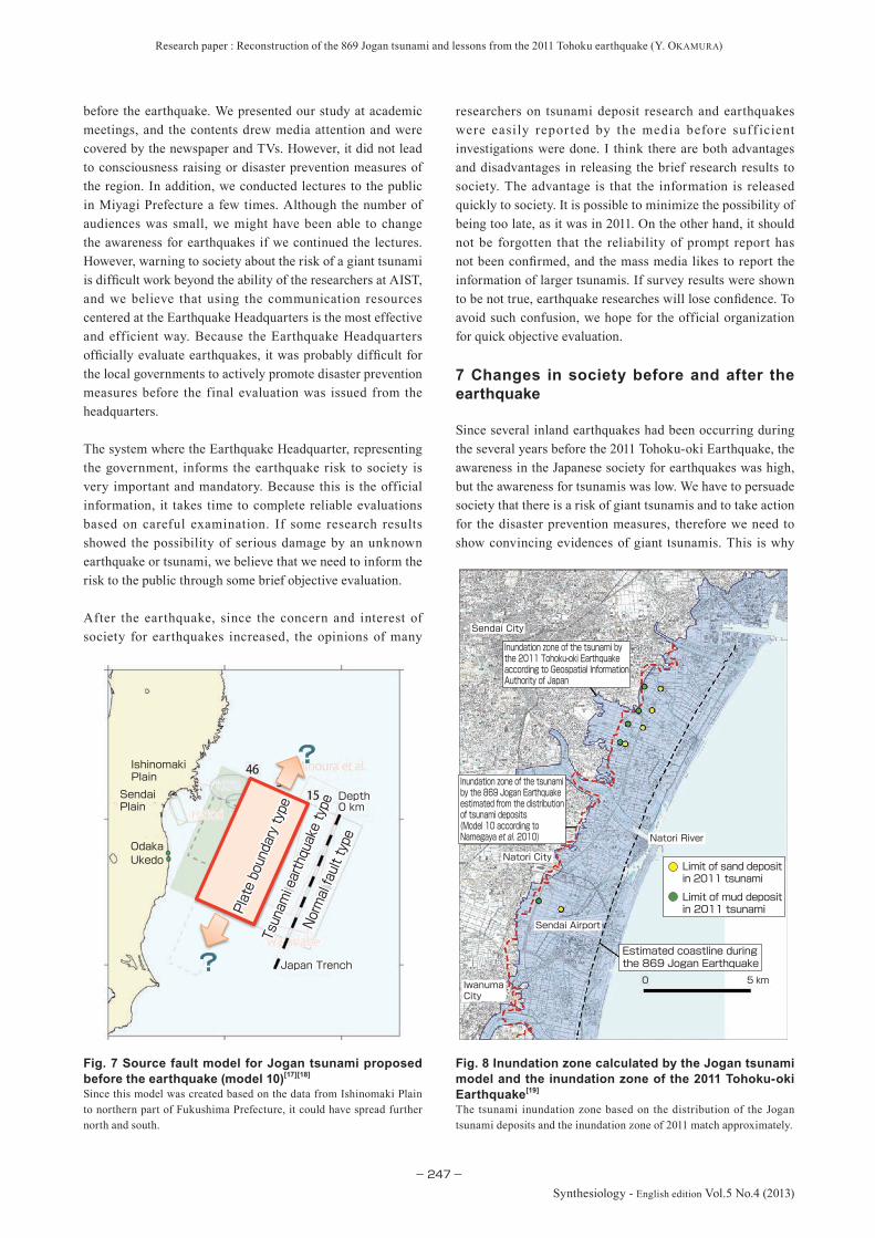
(Fig. 6). As a result, we presumed that a tsunami inundates all the way to the distribution zone of the tsunami deposits by an earthquake of magnitude 8.4 caused by a 7 m slip (fault displacement) of an area with length of 200 km and width of 100 km along the plate boundary at a depth of 15-46 km off the Miyagi to Fukushima Prefectures.[17][18] However, this earthquake source fault model did not consider the possibility that the tsunami inundation zone was wider than the distribution zone of tsunami deposits. Also since the northern and southern limits of the inundation zone were unclear, there was a possibility that the scale of the earthquake might be greater[12] (Fig. 7).
5 Jogan Earthquake model evaluated by the actual earthquake
One of the major reasons that the earthquake prediction research does not advance is because actual experiments cannot be conducted. The currently used science and technology were built upon repeated experiments, and there must have been numerous failures. On the other hand, the scale of a natural phenomenon is incomparably large. While rock deformation experiments can be done in the laboratory, a natural earthquake cannot be predicted by such experimental results only. The dynamic characteristics of deep underground rock is becoming clarified by the rock deformation experiments under high temperature and pressure conditions, but there are many unknowns about the
actual deep underground conditions such as the diversity of rock types and the presence of fluid. It is impossible to recreate such natural conditions perfectly in the laboratory. Therefore, seismology has been advanced by the analysis of earthquakes that actually occurred.
Even if the images of past earthquakes are recreated based on the tsunami deposits, they cannot be verified unless an ear thquake actually occurs. The 2011 Tohoku-oki Earthquake was the first earthquake and giant tsunami that occurred in the area where the past earthquakes have been estimated by researches using the tsunami deposits, and it has provided an opportunity to examine the reliability of our paleoseismological research.
The Jogan Earthquake model estimated to be of magnitude 8.4 or greater was smaller than the magnitude of the 2011 Tohoku-oki Earthquake. However, in the Sendai Plain, there was no major difference between the inundation areas of tsunamis by the 869 and 2011 earthquakes [19] (Fig. 8). According to the study of tsunami deposits formed by the 2011 earthquake, it was shown that the tsunami (seawater) reached about 1~2 km inland further than the area where tsunami deposit (sand layer) was formed.[19] This finding is extremely important for the estimation of the magnitude of the tsunami from the distribution of tsunami deposits. It is necessary to reevaluate the magnitude of the Jogan tsunami taking this difference into account. It is expected that the
Fig. 5 Example of calculation of the Jogan tsunami source model (edited from References [17] and [18])The tsunami was calculated by assuming the fault planes with different scale on the subducting Pacific Plate offshore of Tohoku.
Ishinomaki Plain
Sendai Plain
Plate boundary type
Normal fault type
Tsunam
i earthquake
type
Minoura et al.
Hatori
Watanabe
Hatori
Watanabe
2005
1978
2005
197815
3146
0 km0 kmDepthDepth
Japan TrenchJapan Trench
OdakaUkedo
7 m7 m
Mw 8.4Mw 8.4
Model 10Model 10Inter plate d15_L200_W100_u7Inter plate d15_L200_W100_u7
Ishinomaki Plain
Sendai Plain
Plate boundary type
Normal fault type
Tsunam
i earthquake
type
Minoura et al.
Hatori
Watanabe
Hatori
Watanabe
2005
1978
2005
197815
3146
0 km0 kmDepthDepth
Japan TrenchJapan Trench
OdakaUkedo
7 m7 m
Mw 8.4Mw 8.4
Model 11Model 11Inter plate d31_L200_W100_u7Inter plate d31_L200_W100_u7
Ishinomaki Plain
Sendai Plain
Plate boundary type
Normal fault type
Tsunam
i earthquake
type
Minoura et al.
Hatori
Watanabe
Hatori
Watanabe
2005
1978
2005
197815
3146
0 km0 kmDepthDepth
Japan TrenchJapan Trench
OdakaUkedo
5 m5 m
Mw 8.3Mw 8.3
Model 5Model 5Inter plate d15_L200_W100_u5Inter plate d15_L200_W100_u5
Ishinomaki Plain
Sendai Plain
Plate boundary type
Normal fault type
Tsunam
i earthquake
type
Minoura et al.
Hatori
Watanabe
Hatori
Watanabe
2005
1978
2005
197815
3146
0 km0 kmDepthDepth
Japan TrenchJapan Trench
OdakaUkedo
5 m5 m
Mw 8.3Mw 8.3
Model 6Model 6Inter plate d31_L200_W100_u5Inter plate d31_L200_W100_u5
Ishinomaki Plain
Sendai Plain
Plate boundary type
Normal fault type
Tsunam
i earthquake
type
Minoura et al.
Hatori
Watanabe
Hatori
Watanabe
2005
1978
2005
197815
3146
0 km0 kmDepthDepth
Japan TrenchJapan Trench
OdakaUkedo
5 m5 m
Mw 8.1Mw 8.1
Model 1Model 1Normal fault typeNormal fault type
Ishinomaki Plain
Sendai Plain
Plate boundary type
Normal fault type
Tsunam
i earthquake
type
Minoura et al.
Hatori
Watanabe
Hatori
Watanabe
2005
1978
2005
197815
3146
0 km0 kmDepthDepth
Japan TrenchJapan Trench
OdakaUkedo
5 m5 m
Mw 8.1Mw 8.1
Model 2Model 2Tsunami earthquake typeTsunami earthquake type
Ishinomaki Plain
Sendai Plain
Plate boundary type
Normal fault type
Tsunam
i earthquake
type
Minoura et al.
Hatori
Watanabe
Hatori
Watanabe
2005
1978
2005
197815
3146
0 km0 kmDepthDepth
Japan TrenchJapan Trench
OdakaUkedo
5 m5 m
Mw 8.1Mw 8.1
Model 3Model 3Inter plate d15_L200_W50_u5Inter plate d15_L200_W50_u5
Ishinomaki Plain
Sendai Plain
Plate boundary type
Normal fault type
Tsunam
i earthquake
type
Minoura et al.
Hatori
Watanabe
Hatori
Watanabe
2005
1978
2005
197815
3146
0 km0 kmDepthDepth
Japan TrenchJapan Trench
OdakaUkedo
5 m5 m
Mw 8.1Mw 8.1
Model 4Model 4Inter plate d31_L200_W50_u5Inter plate d31_L200_W50_u5

Research paper : Reconstruction of the 869 Jogan tsunami and lessons from the 2011 Tohoku earthquake (Y. Okamura)
−246−Synthesiology - English edition Vol.5 No.4 (2013)
accuracy of tsunami magnitude prediction can be improved by applying this result of tsunami deposit research in other ocean areas.
The Tohoku-oki Earthquake proved that the tsunami deposits were highly reliable evidences of the past giant tsunamis, and these deposits must be taken as important warnings from nature. On the other hand, there were some problems for estimation of tsunami magnitude.
6 Announcing the earthquake study to society
There was a common preconception that ear thquakes would not strike the Kansai district before the 1995 Kobe Earthquake, but active fault researchers clarified that Mt. Rokko had been uplifting due to fault activity and that there was a possibility of a major earthquake in Kobe. The knowledge of such researchers were not utilized in the regional disaster prevention. To utilize the research results of earthquake research in the earthquake disaster prevention in society, it was determined that the government must evaluate the research results objectively and then provide this information to society as reliable crucial information impor tant for d isaster prevent ion. The Ear thquake Headquarters was established to achieve this mission (Fig. 9).
After the 1995 Kobe Earthquake, the danger of active faults
became widely known, the research to clarify the activity history was conducted, and the active fault evaluation was published by the Earthquake Headquarters. The subduction zone earthquakes were evaluated based mainly on historical records. Through such evaluation and publication of the dangers of earthquake by the Earthquake Headquarters, the local governments and society became aware of the danger and had to take action for disaster mitigation.
The research results of the Jogan Earthquake discussed earl ier were submit ted by AIST to the Ear thquake Headquarters in the spring of 2010, and the headquarters conducted evaluations for about one year, for earthquakes along the entire Japan Trench. If the Tohoku-oki Earthquake did not occur, the evaluation of the Jogan Earthquake would have been announced in April 2011. Since it would take some time to prepare for the disaster prevention measures, it is unknown how it could have helped the disaster mitigation. At least it would have been an opportunity for many people to know the possibility that a giant tsunami might strike the Ishinomaki, Sendai, and the Fukushima coasts.
We are regret table that the research results were not announced from the Earthquake Headquarters before the earthquake, and we are still thinking that the information might have mitigated the damage to some degree. At the same time, we had been trying to inform others of our research
Fig. 6 Example of calculation of the inundation area based on the Jogan tsunami source model (edited from References [17] and [18])The inundation zones of Ishinomaki Plain (top) and Sendai Plain (bottom) based on models 5, 6, 10, and 11 of Fig. 5. Ultimately model 10 (second from right) was selected as the Jogan model.
Mw8.3 Mw8.3 Mw8.4 Mw8.4
Mw8.4Mw8.4Mw8.3Mw8.3
Sendai Plain
Ishinomaki Plain
Slip 5 mMw8.3
Slip 7 mMw8.4
Model 5:d15L200W100u5 Model 6:d31L200W100u5 Model 10:d15L200W100u7 Model 11:d31L200W100u7
Research paper : Reconstruction of the 869 Jogan tsunami and lessons from the 2011 Tohoku earthquake (Y. Okamura)
−247−
Synthesiology - English edition Vol.5 No.4 (2013)
before the earthquake. We presented our study at academic meetings, and the contents drew media attention and were covered by the newspaper and TVs. However, it did not lead to consciousness raising or disaster prevention measures of the region. In addition, we conducted lectures to the public in Miyagi Prefecture a few times. Although the number of audiences was small, we might have been able to change the awareness for earthquakes if we continued the lectures. However, warning to society about the risk of a giant tsunami is difficult work beyond the ability of the researchers at AIST, and we believe that using the communication resources centered at the Earthquake Headquarters is the most effective and efficient way. Because the Earthquake Headquarters officially evaluate earthquakes, it was probably difficult for the local governments to actively promote disaster prevention measures before the final evaluation was issued from the headquarters.
The system where the Earthquake Headquarter, representing the government, informs the earthquake risk to society is very important and mandatory. Because this is the official information, it takes time to complete reliable evaluations based on careful examination. If some research results showed the possibility of serious damage by an unknown earthquake or tsunami, we believe that we need to inform the risk to the public through some brief objective evaluation.
After the earthquake, since the concern and interest of society for earthquakes increased, the opinions of many
researchers on tsunami deposit research and earthquakes were easily repor ted by the media before suff icient investigations were done. I think there are both advantages and disadvantages in releasing the brief research results to society. The advantage is that the information is released quickly to society. It is possible to minimize the possibility of being too late, as it was in 2011. On the other hand, it should not be forgotten that the reliability of prompt report has not been confirmed, and the mass media likes to report the information of larger tsunamis. If survey results were shown to be not true, earthquake researches will lose confidence. To avoid such confusion, we hope for the official organization for quick objective evaluation.
7 Changes in society before and after the earthquake
Since several inland earthquakes had been occurring during the several years before the 2011 Tohoku-oki Earthquake, the awareness in the Japanese society for earthquakes was high, but the awareness for tsunamis was low. We have to persuade society that there is a risk of giant tsunamis and to take action for the disaster prevention measures, therefore we need to show convincing evidences of giant tsunamis. This is why
Fig. 7 Source fault model for Jogan tsunami proposed before the earthquake (model 10)[17][18]
Since this model was created based on the data from Ishinomaki Plain to northern part of Fukushima Prefecture, it could have spread further north and south.
Fig. 8 Inundation zone calculated by the Jogan tsunami model and the inundation zone of the 2011 Tohoku-oki Earthquake[19]
The tsunami inundation zone based on the distribution of the Jogan tsunami deposits and the inundation zone of 2011 match approximately.
Plate boundary type
Plate boundary type
Normal fault type
Normal fault type
Tsunam
i earthquake type
Tsunam
i earthquake type
Ishinomaki Plain
Sendai Plain
OdakaUkedo
DepthDepth0 km0 km
Japan TrenchJapan Trench
Inundation zone of the tsunami by the 2011 Tohoku-oki Earthquake according to Geospatial Information Authority of Japan
Inundation zone of the tsunami by the 869 Jogan Earthquake estimated from the distribution of tsunami deposits(Model 10 according to Namegaya et al. 2010)
Estimated coastline during the 869 Jogan Earthquake
Limit of sand deposit in 2011 tsunami
Limit of mud deposit in 2011 tsunami
5 km0
Sendai City
Natori City
Natori River
Sendai Airport
Iwanuma City

Research paper : Reconstruction of the 869 Jogan tsunami and lessons from the 2011 Tohoku earthquake (Y. Okamura)
−248−Synthesiology - English edition Vol.5 No.4 (2013)
we took considerable time in conducting tsunami deposit research carefully. We estimated the minimum magnitude of the tsunami by the Jogan earthquake based on the detailed tsunami deposit research. Our study will lose reliability if we estimated too large an earthquake and tsunami without convincing evidences. After the 2011 earthquake, there was a period where we wondered whether this policy was correct. However, if we had announced a large tsunami prediction without presenting clear evidence to society before the earthquake, we think that our model would have been neglected. We believe our research policy was not wrong.
The concern for earthquakes immediately rose after the tsunami devastated the coastal area of Tohoku on March 11, 2011. While the government and the local governments used to be reluctant to assume large earthquakes without sufficient evidence before the 2011 earthquake, they changed the policy to assume the worst possible earthquake and tsunami.[20] Under this policy, assumption of the worst possible earthquake and tsunami that may happen have been adopted, rather than an earthquake which had been confirmed in the past. The earthquake researches are demanded to determine the magnitude of the largest earthquake. It is not too much to say that the demand for earthquake research changed around 180 degrees. Unfortunately, current earth science cannot determine the largest earthquake reasonably. As a result, there are possibilities that unnecessarily large earthquakes and tsunamis may be assumed. The research to determine the appropriate maximum earthquakes is necessary.
8 Future issues
The Japanese society will be unable to recover from the shock of Tohoku-oki Earthquake for a while. Whatever size of earthquake and tsunami will be assumed in the future, we will not be freed from the fear of earthquakes and tsunamis. The disaster prevention measures to mitigate the damages
from earthquakes and tsunamis must be steadily conducted to decrease the fear, but it is not easy to determine the appropriate measures against the large tsunamis. The sense of crisis over natural disaster must be sustained even after the disaster prevention measures are taken. Considering the role of the geology fields at AIST (Geological Survey of Japan), the most important missions are to conduct careful research of the past earthquakes, to clarify what earthquake occurred in which area, and to continue providing this information to society. In addition, it is necessary to show what is known and unknown about ancient earthquakes based on the current level of natural sciences. It is then necessary to consider how the measures should be taken as a society as a whole.
For the research results of AIST to be utilized widely in society, I mentioned that we need a system in which the results are reevaluated and announced by the Earthquake Headquarters as an official organization. However, this alone does not ensure sufficient dissemination of information to the regional communities, and the process usually takes time. It is considered that AIST must directly provide detailed information to the local governments and communities about the information on which the evaluation of the Earthquake Headquarters is based and what are the issues, and at the same time actively exchange information. Moreover, we may consider information provision to local governments before the announcement of the Earthquake Headquarters. To conduct such information exchange, it is necessary to establish mutual trust by holding meetings with the prefectural and other local governments regularly.
At the same time, it is necessary to design land use plans in Japan based upon an understanding of nature and the evaluation of various disasters. For better land use, comprehensive knowledge about the geological characteristics of the Japanese Archipelago needs to be provided. The Japanese have experienced various damages from natural disasters and have overcome them and built the prosperity today. For example, the technology of earthquake resistant structures of Japan is the most advanced in the world. However, it must be said that society as a whole is becoming vulnerable to natural disasters. One of the reasons may be that the people are becoming less knowledgeable about nature. By understanding the crustal movement in the Japanese Archipelago that occurred in the past tens of thousands of years based on geology, I hope people will become prepared against natural disasters. The mission of the geology field of AIST is to provide such information to society.
Acknowledgement
The research of the Jogan Earthquake was conducted through the collaboration of the following researchers: Masanori Shishikura, Yuki Sawai, and Yuichi Namegaya, researchers
Fig. 9 Role of the Earthquake HeadquartersThe Earthquake Headquarters or the Headquarters for Earthquake Research Promotion, MEXT, gathers information from the survey and research institutes for earthquakes, reevaluates the information, and announces the scale and probability of the earthquakes that may occur in the future.
Announcement of the evaluation
Subcommittee for Long-term Evaluation 2010
Announcement in April 2011?
Disaster prevention measures of Government, regional area, and society
Universities, research institutes, etc.
Master planSurvey & measurement plan
Survey & measurement dataResearch product
Earthquake Research CommitteePolicy Committee
Research project on Miyagi-oki Earthquake 2005-2009
Earthquake Headquarters, MEXT
Researc
hEvalu
ation
by
government
Publicit
y

Research paper : Reconstruction of the 869 Jogan tsunami and lessons from the 2011 Tohoku earthquake (Y. Okamura)
−249−
Synthesiology - English edition Vol.5 No.4 (2013)
of the Active Fault and Earthquake Research Center, AIST; and Professor Kenji Satake, Earthquake Research Institute, The University of Tokyo. This research was made possible by the cooperation of the landowners and related organizations at the site. I am grateful to all the people who were involved.
References
[1] The Headquarters for Earthquake Research Promotion: Fundamental Earthquake Survey and Observation Plans http://www.jishin.go.jp/main/seisaku/hokoku97/s8kei.htm#1-1 (1997) (in Japanese).
[2] T. Usami: Saishinban Nihon Higai Jishin Soran 416-2001 (Materials for Comprehensive List of Destructive Earthquakes in Japan, Latest Edition), University of Tokyo Press (2003) (in Japanese).
[3] K. Ishibashi and K. Satake: Problems on forecasting great earthquakes in the subduction zones around Japan by means of paleoseismology, Zisin (J. Seism. Soc. Japan), 50, Appendix, 1 -21 (1998) (in Japanese).
[4] The Headquarters for Earthquake Research Promotion: Sanriku Oki kara Boso Oki ni kakete no jishin katsudo no choki hyoka no ichibu kaitei nitsuite (Regarding the partial revision of the long-term evaluation of earthquake activity of off-shore of Sanriku to Boso area) http://www.jishin.go.jp/main/chousa/09mar_sanriku/index.htm (2009) (in Japanese).
[5] K. Hirakawa, Y. Nakamura and T. Haraguchi: Hokkaido Tokachi engan chiiki ni okeru kyodai tsunami to sairai kankaku (Giant tsunami in the Tokachi coastal region, Hokkaido and the recurrence interval), Chikyu Monthly Symposium, 28, 154-161 (2000) (in Japanese).
[6] F. Nanayama, K. Satake, K. Shimokawa, K. Shigeno, R. Furukawa, I. Hirota, A. Makino, J. Nojima, S. Koitabashi and M. Ishii: Chishima Kaiko engan iki, Kir itappu Shitsugen ni oite kakunin sareta kyodai jishin tsunami ibento (Mega earthquake tsunami event observed in the Kiritappu marsh in the coastal area of Kuril Trench), Chikyu Monthly Symposium, 28, 139-146 (2000) (in Japanese).
[7] F. Nanayama, K. Satake, R. Furukawa, K. Shimokawa, B. F. Atwater, K. Shigeno and S. Yamaki: Unusually large earthquakes inferred from tsunami deposits along the Kuril trench, Nature, 424, 660-663, doi:10.1038/nature01864 (2003).
[8] K. Satake and F. Nanayama: Tsunami inundation maps for the Pacific coast of Hokkaido, Numerical Geological Map EQ-1, Geological Survey of Japan, AIST, (2004) (in Japanese).
[9] K. Satake, F. Nanayama and S. Yamaki: Fault models of unusual tsunami in the 17th century along the Kuril trench, Earth Planets Space, 60, 925-935 (2008).
[10] Y. Tsuji and K. Ueda: Kencho 16 nen (1611), Enpo 5 nen (1677), Horeki 12 (1763), Kansei 5 nen (1793), oyobi Ansei 3 nen (1856) no kaku Sanriku Jishin tsunami no kensho [Investigation of Sanriku Earthquake tsunami in Kencho 16 (1611), Enpo 5 (1677), Horeki 12 (1763), Kansei 5 (1793) and Ansei 3 (1856)], Rekishi Jishin (J. Soc. Historical Earthquake), 11, 75-106 (1995) (in Japanese).
[11] T. Yoshida: Jogan 11 nen Mutsu-fu-jo no shindo koitsu (Earthquake and f looding of Mutsu State Castle in Jogan 11), Rekishi Chiri (Historical Geography), 8 (12), 1033-1040 (1906) (in Japanese).
[12] M. Shishikura, Y. Sawai, Y. Namegaya and Y. Okamura: Heian no hitobito ga mita kyodai tsunami wo saigensuru
– seireki 869 Jogan Tsunami (Reconstructing the giant tsunami seen by the people of Heian Period – Jogan Tsunami of AD 869), AFERC News, 16 (2010) (in Japanese).
[13] H. Abe, Y. Sugeno and A. Chigama: Estimation of the height of the Sanriku Jogan 11 earthquake-tsunami (A.D.869) in the Sendai plain, Zisin (J. Seism. Soc. Japan), 43, 513-525 (1990) (in Japanese).
[14] K. Minoura and S. Nakaya: Traces of tsunami preserved in inter-tidal lacustrine and marsh deposits: some examples from northeast Japan, Journal of Geology, 99, 265-287 (1991).
[15] M. Shishikura, Y. Sawai, Y. Okamura, J. Komatsubara, T. T. Aung, T. Ishiyama, O. Fujiwara and S. Fujino: Age and distribution of tsunami deposit in the Ishinomaki Plain, Northeastern Japan, Annual Report on Active Fault and Paleoearthquake Researches, 7, 31-46 (2007) (in Japanese).
[16] Y. Sawai, Y. Okamura, M. Shishikura, T. Matsuura, T. T. Aung, J. Komatsubara and Y. Fujii: Historical tsunamis recorded in deposits beneath Sendai Plain - Inundation areas of the A.D. 1611 Keicho and the A.D. 869 Jogan tsunamis, Chishitsu News, 624, 36-41 (2006) (in Japanese).
[17] K. Satake, Y. Namegaya and S. Yamaki: Numerical simulation of the AD 869 Jogan tsunami in Ishinomaki and Sendai plains, Annual Report on Active Fault and Paleoearthquake Researches, 8, 71-89 (2008) (in Japanese).
[18] Y. Namegaya, K. Satake and S. Yamaki: Numerical simulation of the AD 869 Jogan tsunami in Ishinomaki and Sendai plains and Ukedo river-mouth lowland, Annual Report on Active Fault and Paleoearthquake Researches, 10, 1-21 (2010) (in Japanese).
[19] M. Shishikura: Tsunami taisekibutsu kara mita 869 Jogan Jishin to 2011 nen Tohoku Chiho Taiheiyo Oki Jishin nitsuite (Comparison of the 869 Jogan Earthquake and the 2011 Earthquake off the Pacific coast of Tohoku from tsunami deposits), Seism. Soc. Japan News Letter, 23 (3), (2011) (in Japanese).
[20] Central Disaster Management Council: Report of the Committee for Technical Investigation on Countermeasures for Earthquakes and Tsunami Based on the Lessons Learned from the “2011 Off the Pacific Coast of Tohoku Earthquake” http://www.bousai.go.jp/jishin/chubou/higashinihon/index_higashi.html (2011) (in Japanese).
Author
Yukinobu OkamuraCompleted the master’s course at the Graduate School of Science, Nagoya University in 1980. Joined the Geological Survey of Japan, Agency of Industrial Science and Technology, Ministry of International Trade and Industry in 1980. Engaged in the marine geological surveys around Japan for about 24 years, created the marine geological maps, and studied the formation of the geologic structures. Participates in the research of tsunami deposits at the Active Fault and Earthquake Research Center, AIST from 2004. Director of AFERC since 2009.

Research paper : Reconstruction of the 869 Jogan tsunami and lessons from the 2011 Tohoku earthquake (Y. Okamura)
−250−Synthesiology - English edition Vol.5 No.4 (2013)
Discussions with Reviewers
1 Overall comment 1Comment (Shigeko Togashi, AIST)
This paper discusses the way in which science may contribute to society through the research of long-term earthquake prediction that may help disaster prevention, by thoroughly clarifying the geological evidences of tsunami deposit and then estimating the image of past earthquakes using the geophysical methods.
Specifically, 1) the paper presents a scientific methodology in which the reconstruction model of past earthquake is created by integrating the data with differing time scale such as geological record of tsunami deposit, historical record, observation record, and others, then simulating a geophysical model, and improving the prediction accuracy by verifying the model against the earthquake that actually occurred. 2) It also discusses the method for realistically contributing to disaster prevention by quickly and accurately announcing the latest research results to society, even if it is in mid-research stage, including the areas that may be still uncertain.
This paper raises important issues from the perspective of methodology for how science may contribute to society, and I think it is appropriate as a paper to be published in Synthesiology.
Upon review, the paper was revised to clearly state the significance of the aforementioned methodology.
2 Overall comment 2Comment (Akira Ono, AIST)
I think the ear thquake model construction method, in which the elemental research of geological survey of tsunami deposit and the geophysical method were combined to achieve the research objective of reconstructing paleo-earthquakes, is an excellent Type 2 Basic Research. I respect the fact that this research was perfected at a high level before the occurrence of the 2011 Tohoku-oki Earthquake.
In this research, the Jogan Earthquake was reconstructed accurately. It is regretful that the results could not be announced before the tsunami of the Tohoku-oki Earthquake. On the other hand, while it was completely coincidental that the constructed ear thquake model was verif ied immediately by the actual phenomenon, it was greatly signif icant in considering the measures against future large-scale earthquakes. I think the earthquake model that was constructed will be useful in reliably predicting large-scale earthquakes and accompanying tsunamis that are expected to occur in the future in the Tokai, Tonankai, and Nankai areas.
3 Approaches in geology and geophysicsComment (Akira Ono)
In this paper, you describe the role, mission, and position of the geology groups within AIST. Considering that Synthesiology is read by people of wide-ranging fields, can you expand the description to “seismology” or “earthquake studies” rather than keeping yourself within the geology of “AIST”?Answer (Yukinobu Okamura)
The mainstream of “seismology” or “earthquake studies” is the research based on geophysics, and the research based on geology conducted at AIST is a minority. This minor research drew attention after the Tohoku-oki Earthquake. The mainstream researchers are working to f igure out the reason why they were unable to issue preliminary warnings, and are discussing the direction of future research based on the lessons learned. The objective of this paper is to emphasize the importance of earthquake research based on geology and to discuss the various issues. Widening the discussion to the entire seismology will derail from the main topic, and I feel it is too much of a load for me. In the “Introduction,” I added some simple description of the difference between AIST and the mainstream earthquake researches.
4 Presentation of a flowchart of the paleo-tsunami research as a scientific methodologyComment (Shigeko Togashi)
I think it wil l help our understanding if you draw a generalized flowchart of the paleo-tsunami research as a scientific methodology.Answer (Yukinobu Okamura)
I created my version of the flowchart in Fig. 2, based on the sample.
5 Action for the “organization of a system for quick objective evaluation”Comment (Shigeko Togashi)
What are the actions for the “organization of a system for quick objective evaluation” mentioned at the end of chapter 6?Answer (Yukinobu Okamura)
The objective evaluation must be conducted by a national organization such as the Earthquake Research Committee, and I think it will be most efficient if the government’s evaluation process is accelerated, but it is not easy to do so. Another method is the publication as papers of the correct method for tsunami deposit research. If the researchers publish highly reliable results, I think highly reliable tsunami evaluation will spread quickly throughout society.