Embed Size (px)
Citation preview
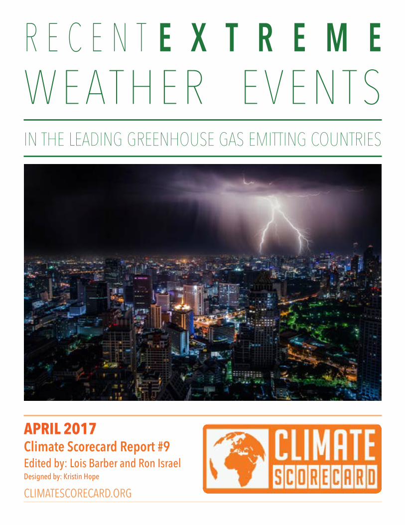
W E AT H E R E V E N T SR E C E N T
Climate Scorecard Report #9Edited by: Lois Barber and Ron IsraelDesigned by: Kristin Hope
APRIL 2017
CLIMATESCORECARD.ORG
IN THE LEADING GREENHOUSE GAS EMITTING COUNTRIES
E X T R E M E
2
TABLE O F CONTENTS
Action Alert 3
Introduction 4
Table 5
Argentina 6
Australia 7
Brazil 8
Canada 10
China 11
France 12
Germany 13
India 14
Indonesia 15
Italy 16
Japan 17
Mexico 17
Nigeria 19
Russia 20
Saudi Arabia 22
South Korea 24
Spain 25
Thailand 26
Turkey 28
United Kingdom 29
United States 30
About Climate Scorecard 32
3
The growing prevalence of climate change related extreme weather events in countries around the world closely matches what was, and is, predicted by climate scientists. Scientific weather modeling has shown that these extreme weather events will increase as a result of greenhouse gases being emitted into the atmosphere at ever growing levels. In addition to pressing governments to do everything possible to reduce greenhouse gas emissions, we also need to press governments to do more to prepare in advance for extreme weather events.
TAKE ACTION
All governments, including Heads of Government, Cabinet Ministers, and Members of Parliament and Congress: Develop and implement policies and legislation that will invest more in early warning systems, better infrastructure to mitigate damage caused by floods and drought, and improve disaster relief services for those affected.
Governments of more industrialized countries: Develop and implement policies to provide financial and other assistance to less industrialized countries to help them address the devastating effects of a changing climate.
The NGO community: Press your government to invest more in mitigating the impact of extreme weather events, and to do more to help prepare your communities, and communities worldwide, to prepare and respond to extreme weather.
The business community: Invest more in research and development of technologies that can help governments and their citizens withstand the effects of extreme weather.
Recent Extreme Weather Events: Climate Scorecard Country Summary Report #9
ACTION ALERT
4
Climate Scorecard Report #9 focuses on documenting extreme weather events over the past three years in the world’s leading greenhouse gas emitting countries. The International Panel on Climate Change (IPCC), the World Meteorological Association, and other groups have documented global warming trends. We know for a fact that the world is getting warmer with each succeeding year; 2016 being documented as the warmest year on record. (1)
Climate Scorecard’s Report # 9 puts meat on the bone to these aggregate statistics. A review of this Report shows that in country after country the effects of climate-change induced extreme weather is being critically felt. Climate change is affecting country plans for economic development and growth, eroding basic infrastructure, ruining the livelihoods of millions of people, affecting health and taking peoples’ lives.
Our Report shows that no country or region is being spared. For example, in the Americas we see severe flooding in Argentina, multi-year droughts in Northeast Brazil and in the State of California in the United States, devastating wildfires in the provinces of British Columbia and Alberta, Canada, and a Category 5 hurricane in Mexico.
Africa and the Middle East also bear witness to extreme weather events: the worst flood in 40 years in Nigeria, severe extended country-wide drought in South Africa, and rare extreme rainfall and flooding in Jeddah City in Saudi Arabia.
The effects of recent extreme weather have also been felt throughout Europe and Eurasia. Severe storms Xynthia (France ) and Egon (Germany), caused widespread devastation in these countries. In Italy in 2014, an unprecedented amount of rain feel on the city of Genoa causing flooding, landslides, and millions of Euros in damage. Extreme droughts and then floods ravaged Eastern Spain. Russia’s Federal Service of Hydrometeorology and Environmental Monitoring documented an upward spike in Russian incidents of extreme weather events over the past nine years.
The situation is the same in Asia. Australia’s Great Barrier Reef experienced unprecedented bleaching and was declared dead. China suffered through Typhoon Nepartak—a category 5 super typhoon. The 2013 Uttarakhand Flash Floods in the Himalaya Region of India resulted in the deaths of thousands of people and millions of dollars of property loss. In Indonesia in 2015, wildfires engulfed 2.6 million hectares of land and tripled the country’s carbon emissions.
Lack of preparedness and responsiveness to these extreme weather events is a major lesson to be learned from the information in this Report. In country after country we see governments failing to adequately invest in early warning systems, better infrastructure to mitigate damage caused by flooding and drought, and improved disaster relief services for those affected. We see NGOs who need to do more to help prepare those in the communities where they operate to cope with extreme weather. And we see the business community failing to invest in research and technologies that can help governments and their citizens withstand the effects of extreme weather.
There are some exceptions. China, for example, has recently launched a major effort to implement early
INTRODUCTION
5
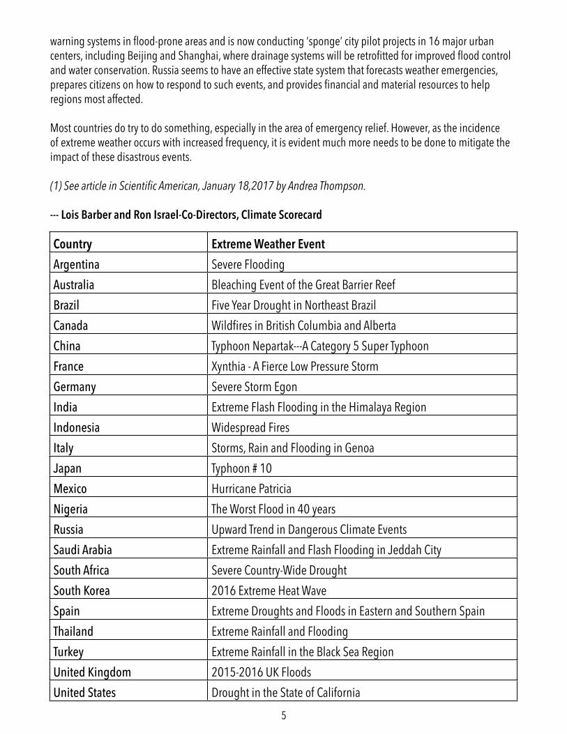
Country Extreme Weather EventArgentina Severe FloodingAustralia Bleaching Event of the Great Barrier ReefBrazil Five Year Drought in Northeast BrazilCanada Wildfires in British Columbia and AlbertaChina Typhoon Nepartak---A Category 5 Super TyphoonFrance Xynthia - A Fierce Low Pressure StormGermany Severe Storm EgonIndia Extreme Flash Flooding in the Himalaya RegionIndonesia Widespread FiresItaly Storms, Rain and Flooding in GenoaJapan Typhoon # 10Mexico Hurricane PatriciaNigeria The Worst Flood in 40 yearsRussia Upward Trend in Dangerous Climate EventsSaudi Arabia Extreme Rainfall and Flash Flooding in Jeddah CitySouth Africa Severe Country-Wide DroughtSouth Korea 2016 Extreme Heat WaveSpain Extreme Droughts and Floods in Eastern and Southern SpainThailand Extreme Rainfall and FloodingTurkey Extreme Rainfall in the Black Sea RegionUnited Kingdom 2015-2016 UK FloodsUnited States Drought in the State of California
warning systems in flood-prone areas and is now conducting ‘sponge’ city pilot projects in 16 major urban centers, including Beijing and Shanghai, where drainage systems will be retrofitted for improved flood control and water conservation. Russia seems to have an effective state system that forecasts weather emergencies, prepares citizens on how to respond to such events, and provides financial and material resources to help regions most affected.
Most countries do try to do something, especially in the area of emergency relief. However, as the incidence of extreme weather occurs with increased frequency, it is evident much more needs to be done to mitigate the impact of these disastrous events.
(1) See article in Scientific American, January 18,2017 by Andrea Thompson.
--- Lois Barber and Ron Israel-Co-Directors, Climate Scorecard
6
ARGENTINASubmitted by Climate Scorecard Country Manager DUSTIN ROBERTSON
Severe Flooding
Argentina is particularly vulnerable to natural disasters. Because of its large surface area and unique geography, the country is prone to desertification, flooding, drought, volcanic eruptions, heavy snowfalls, landslides, earthquakes, and tornados. The direct impact of climate change has been observed across the country in recent years. Slow and gradual changes such as increased precipitation and temperatures have been observed in many parts of the country. In addition, Argentina has also suffered numerous extreme climate events that have resulted in disasters.
Flooding
Flooding is becoming a regular occurrence in many parts of the country. A combination of climatic factors including heavy rainfall and swollen rivers has produced devastating floods in recent years. In 2015, the country experienced floods which officials described as “the worst in five decades.” In the Northeastern city of Concordia, as many as 20,000 people were forced to evacuate. Just a year later, hundreds were forced from their homes in the provinces of Santa Fe and Buenos Aires.
In addition to disrupting the lives of Argentina’s citizens, the flooding has also devastated agricultural areas threatening the country’s economy and food supply. For example, long term flooding in the northwest region of Buenos Aires province, forced the local government to declare an agricultural emergency.
Argentina Creates New National Observatory on Climate Change
In hopes of detecting and preventing extreme climate events, the Ministry of the Environment and Ministry of Defense have recently signed an agreement to create a National Observatory on Climate Change. The Observatory will create maps and conduct studies on numerous climate risks including floods, droughts, forest fires, heat waves, temperature changes and other extreme climate events.
Learn More
For a description of the massive regional flooding in late 2015: http://www.bbc.com/news/world-latin-america-35184793 To learn more about the numerous effects of flooding in Argentina: http://floodlist.com/tag/argentina
7
AUSTRALIASubmitted by Climate Scorecard Country Manager HANNAH CAMPI
Bleaching Event of the Great Barrier Reef
Warmer water temperatures can result in coral bleaching. When water is too warm, corals will expel the algae zooxanthellae living in their tissues causing the coral to turn completely white. This is called coral bleaching.
The Great Barrier Reef is one of Australia’s most iconic natural features, and has been a harrowing representation of the effects of climate change on the country’s ecosystems. The Reef is currently undergoing the largest bleaching event ever recorded, with some reports showing damage to the system at upwards of 90%. The full environmental effects of this can’t be fully known, as such a large and complex ecosystem plays an important role in biodiversity and oceanic conditions. Additionally, there is a cultural loss for Australians and the potential for a decrease in tourism if Reef degradation continues.
The government has formulated a plan to protect the Great Barrier Reef, the Reef 2050 Plan, which outlines measures that can be taken through 2050 to protect the Reef. The government has outlined 151 actions that can be taken to protect the Reef in the first five years of implementing the plan, and has stated that it is on track with 89% of those actions.
Additionally, heatwaves and wildfires have been increasing both in frequency and intensity. The human impact of these climatic changes has been felt across the country as people endure extended periods of extreme heat that have already characterized 2017.
The government has put out statements on these events, and acknowledged the many extreme and unusual weather events that took place over the course of 2016. The Australia State of the Environment 2016 Overview was recently released and covers trends and changes from 2011-2016. This report outlines where there has been success in management and environmental policies, as well as areas that have seen increased environmental degradation.
The full report can be found here: https://soe.environment.gov.au/
Learn More
http://www.environment.gov.au/marine/gbr/long-term-sustainability-planhttp://earthobservatory.nasa.gov/NaturalHazards/view.php?id=89683
8
Five Year Drought in Northeast Brazil
The Northeast (NE) region of Brazil encompasses the states of Alagoas, Bahia, Ceará, Maranhão, Paraíba, Pernambuco, Piauí and Rio Grande do Norte; it covers 18 % of the Brazilian territory and is home to over 52 million people. The NE is known for its beautiful beaches and friendly people. It is also known for the lowest Human Development Index (HDI) in the country, and its vulnerability to climate change, particularly prolonged droughts and flooding. The region is composed of mostly savannah land (Caatinga) in the interior and remnants of tropical rainforest (the Atlantic Forest) in the coastal areas, most of which—over 90%—are in the state of Bahia.
The Atlantic Forest has suffered extensive deforestation since the Portuguese colonised Brazil, in 1500. First for the extraction of hard wood (mostly the Caesalpinia echinata Lam, which is now almost extinct), and then in the early 17th century, for sugar cane plantations, which intensified in the second half of the 19th century. In the mid 1970s, the cocoa plantations and the pulp and paper industry further contributed to the degradation of this biome. There is an estimated 52,000 Kmsq left of the Atlantic Forest in the NE region, corresponding to about 5% of the original forested area found by the Portuguese in the 16th century. Given this history, the region is particularly vulnerable to desertification, aggravated by climate change.
The Northeast region of Brazil has suffered a five-year drought that is expected to reach a record six-year period by the end of 2017. This is arguably the worst drought on record in the past 100 years. There is high risk of wild fires in remaining forest areas, drying-out of reservoirs and famine in rural areas.The state of Bahia, a popular tourist destination both domestically and internationally, is suffering a period of unusual drought since 2011. This drought has affected over a million people in the region. Summer (December through March) in the NE is usually the rainy season. However, the 2016/2017 summer has been an exceptional one. Per the National Water Agency (ANA) that monitors droughts, there has been a significant decrease in rainfall in most of the region. Maranhão and Piauí have contributed with normal patterns of rainfall to lessen the general impact of the unusually dry period in other states, including Bahia. Most of the Bahia territory was classified as exceptionally or very dry and the affected areas have expanded in the past years. Impacts were considered as long term (ANA, 2017).Feira de Santana is a town located 100 km from the state capital, Salvador. In the past 12 months, the average rainfall in the city has been 12 times less than expected. The State University of Bahia in Feira de Santana forecast 50 mm rainfall for the first quarter of 2017, but so far, only 4mm has fallen in the city. The city has been in a state of emergency since 2011.
Farmers are being hit severely by the drought, and over 64,000 people living in the rural areas surrounding the city are suffering from water shortages and diminished crops. They must walk up to
BRAZILSubmitted by Climate Scorecard Country Manager LAURA VALENTE DE MACEDO
9
300 m to fetch water from a spring, which by now is contaminated and almost dry. One farmer reports that it hasn't rained since July 2016, “even the palm trees are dying”, and he has no hope of recovering his small cassava plantation.
Since December last year, the Ministry of National Integration (MIN) published ordinances acknowledging an emergency in 277 municipalities in Bahia—65% of the cities in the state—due to the NE drought. The measure allows municipalities access to financial aid from federal emergency funds and resources, including water provision and health assistance. The measure also provides support to farmers in debt due to crop losses, and further subsidies from the Brazilian Social Development Bank (BNDES) for agriculture.
The NE region is historically vulnerable to desertification and is expected to suffer the most from climate change. Despite warnings from climate experts and scientific institutions in Brazil, no long-term policies are being implemented in the region to address desertification enhanced by climate change.
Learn More
Sources in Portuguese
TRIBUNA DA BAHIA. Newspaper. Published 21 December 2016. Available at http://www.tribunadabahia.com.br/2016/12/21/seca-na-bahia-afeta-mais-de-um-milhao
G1 Globo.com website. Published 10 March 2017, 10:45pm at http://g1.globo.com/bahia/noticia/2017/03/ministerio-reconhece-situacao-de-emergencia-em-17-cidades-na-bahia.html
G1 Globo.com website. Published 08 March 2017. Available at http://g1.globo.com/bahia/noticia/2017/02/estiagem-atinge-15-mil-produtores-em-cidade-no-sudoeste-baiano.html
National Water Agency (ANA) http://monitordesecas.ana.gov.br/
EBC Brasil. Official communications agency. Published 26 January 2017. Available at http://agenciabrasil.ebc.com.br/geral/noticia/2017-01/pesquisadores-preveem-agravamento-da-seca-no-nordeste-entre-fevereiro-e-abril
FOLHA DE SÃO PAULO. Newspaper. Published in 19 March 2017. Available at http://www1.folha.uol.com.br/poder/2017/03/1867771-em-meio-a-maior-seca-transposicao-do-rio-sao-francisco-divide-nordestinos.shtml
10
Wildfires in British Columbia and Alberta
Between 1995 and 2005, 250 communities and 700,000 Canadians were evacuated due to wildfires. Increasingly catastrophic events include Kelowna, BC (2003), Slave Lake, Alberta (2011), and now Fort McMurray, Alberta (2016). Canada’s Institute for Catastrophic Loss Reduction (ICLR) says three trends contribute to the likelihood of more fire disasters in Canada—more exposure as populations move into wild lands, climate change impacts, and deteriorating forest health conditions causing forest fuel accumulations.
Fort McMurray, May 2016, is the most costly disaster yet in Canadian history. It forced 90,000 citizens to evacuate and destroyed more than 2,400 buildings. Another 2,000 residents in nearby communities were displaced, their homes declared unsafe due to contamination. The fire spread to northern Alberta and into Saskatchewan, destroying forests and impacting Athabasca oil sands operations nearby. Shell, Suncor Energy and Syncrude operations were scaled back. No official fire cause has yet been determined.
ICLR examined neighborhoods at the forested fringes of the city, and acreages nearby discounting direct contact from flames or radiant fire heat as the problem. It concluded wind-driven embers as the probable cause of much of the destruction. Once established, the fire spread from structure to structure, a pattern called ‘wildland/urban interface disaster sequence.’
A set of conditions in urban areas allows for ignition of structures from flames or embers. Typically, when fire behavior peaks due to low humidity, high wind, and very dry fuel, it spreads rapidly with extreme intensity. The winter preceding Fort McMurray’s fires was drier than usual, thus the snowpack melted quickly. This combined with high temperatures, created a ‘perfect storm’. The wildfires will alter how governments, communities and industry prepare for, respond to, and recover from future wildfires to reduce losses. Losses can be reduced by widespread adoption of risk mitigations within the home ignition zone and steps to further secure a community.
Learn More
Canada’s FireSmart program helps communities reduce risk of wildfire damage https://www.firesmartcanada.ca/become-firesmart/community-members/
Canadian wildfire shifts north, prolonging oil sands shutdown. Reuters Canada. May 17, 2016. http://www.thestar.com.my/news/world/2016/05/18/canadian-wildfire-shifts-north-prolonging-oil-sands-
CANADASubmitted by Climate Scorecard Country Manager DIANE SZOLLER
11
shutdown/
Risk reduction status of homes reconstructed following wildfire disasters in Canada. Alan Westhaver, M.Sc., September 2015. http://www.iclr.org/images/Westhaver_wildfire_report_2015.pdf
The State of Canada's Forests 2016 report, this year’s theme is climate change. http://www.nrcan.gc.ca/forests/report/16496
Why some homes survived: Learning from the Fort McMurray wildfire disaster. Alan Westhaver, M.Sc., August 2016, http://www.iclr.org/fortmcmurraypreliminary.html
CHINASubmitted by Climate Scorecard Country Manager LENA COURCOL
Typhoon Nepartak---A Category 5 Super Typhoon
From mid-June through July of 2016, China endured a series of extreme precipitation events, including the tail-end of Typhoon Nepartak—a Category 5 super typhoon—that triggered deadly floods across twenty-six of the nation’s provinces. Official reports published on July 26, 2016 claim that the series of disasters led to a total of 833 deaths, 270 people missing, and a total of 6.24 million residents displaced. The floods have been marked as the world’s second deadliest weather-related event of 2016 and damages, amounting to $22 billion, have been estimated to be the world’s fifth most expensive weather-related natural disaster on record outside of the US.
The climatic severity of these precipitation events and floods was caused by a multitude of factors including, the combination of El Niño and higher levels of atmospheric water vapor caused by global warming. In addition, urbanization and land use changes in cities have led to the enormous demand for housing and the drainage of lakes for further development. This has severely affected the natural drainage system, causing water logging and flooding in the inner city areas.
Although, these factors have drastically influenced the severity of the weather disasters experienced in 2016, China understands that it will continue to see more frequent flooding as Asia’s monsoon system changes as a result of climate change. Adaptation and mitigation to these changes are critical to reducing the vulnerability of those most at risk from precipitation events and flooding.
In the past, the Chinese government focused on environmental restoration, such as (a) afforestation of steep farmlands, (b) restoration of floodplains by removing embankments, (c) resettling farmers in at-risk areas by building new townships; and (d) strengthening river levees and dredging riverbeds.
12
These strategies have not been enough to protect poor farmers and communities—the most vulnerable to flooding. In the early days of August 2016, President Xi Jinping emphasized the importance of early warning systems in flood-prone areas as well as the need for sustainable mitigation strategies focused on engineering solutions. The government is now conducting ‘sponge’ city pilots in 16 major urban centers, including Beijing and Shanghai, where drainage systems will be retrofitted for improved flood control and water conservation. Training of response and rescue personnel and improved access to villages are also required to reach those in risk situations. Community management, particularly by farmers, has been developed to aid flood control, gain greater resilience, and minimize losses.
The increased frequency, severity and unpredictability of weather events caused by climate change are a real threat to China’s population and economy—a fact that will challenge the nation and keep pushing them to develop bold, new mitigation strategies that will create greater resilience in the face of greater risks.
Learn More
http://www.economonitor.com/blog/2016/07/chinas-devastating-floods-from-adaptation-to-mitigation/
http://www.climatesignals.org/headlines/events/china-floods-june-july-2016
http://www.bbc.com/news/world-asia-china-36873902
http://www.aljazeera.com/indepth/inpictures/2016/07/floods-china-kill-dozens-displace-tens-thousands-160723091831354.html
https://www.wri.org/sites/default/files/uploads/wrr_case_study_controlling_yangtze_river_floods.pdf
https://www.researchgate.net/publication/228700173_Strategies_and_Countermeasures_for_Integrated_Urban_Flood_Management_in_China
FRANCESubmitted by Climate Scorecard Country Manager CHARLINE GAUDIN
Xynthia---A Fierce Storm
The storm Xynthia was an intense low pressure system (weather event) which took place on the 27th and 28th of February 2010. It generated extremely severe wind combined with strong high tides and led to very strong and fast land mass submersion with heavy flooding. Five regions of France were

13
strongly affected: Poitou Charentes, Pays de Loire, Aquitaine, Brittany and Normandy. During this storm, 47 persons died in France of which 35 were in Vendée, and 29 in the village of Faute-Sur-Mer. Due to the flooding many people have been displaced and numerous material damages have occurred. This storm is considered one of the strongest and deadliest natural disasters in the past twenty years. It created a deep psychological social trauma in the affected regions.
Following this event, the Government enacted legislative and policy measures. An order recognizing the state of natural disaster was published in the official gazette on the 3rd of March 2010 for four Departments in France. Its aim was to facilitate compensating victims and to trigger insurance mechanisms. In July 2010, the Commissions from the national parliament and the senate issued their reports. More than 100 proposals were made with the main objective to avoid other disasters of this kind. Some recommendations aimed at improving the dissemination of information about what to do in natural disasters; while others recommended increased financial support to municipalities to implement local response plans. New spatial plans were developed and flooded areas were designated “zones of extreme danger” and “black zones. The government bought many houses that were destroyed in these areas.
GERMANYSubmitted by Climate Scorecard Country Manager MARY NTHAMBI
Severe Storm Egon
The storm named Egon in 2017 was one of the strongest storms to hit Germany in recent memory. Storm Egon built up over the Atlantic Ocean on the 10th and 11th of January 2017 due to large hori-zontal differences in air pressure of 850hPa. As a result, the storm was characterized by strong violent winds that travelled at a speed of 315 km/h from Greenland to Scotland to Germany. The storm reached its peak on January 13th, 2017 over west and north Germany. That day, Fichtelberg in the Erzgebirge recorded the strongest wind gust at a speed of 150 km/h. The wind blew across Luxembourg, Saarland, southern Rhineland-Palatinate and Hesse, north of Baden-Württemberg and Bavaria, and southern parts of Thuringia and Saxony.
The storm left behind considerable damage that was way beyond damages caused by other oceanic storms in the past. The strong winds uprooted over 80 trees in Rhineland-Palatinate, Saarland, Hesse, Baden-Wuerttemberg, Thuringia and Bavaria causing train accidents, road traffic and injury of people. In the middle and lower regions of Saarland, buildings and cars were damaged and power lines fell causing power outages to thousands of households. In Hessen, Thuringia, Lower Saxony and Bavaria, road closures and heavy traffic caused by snowdrifts obstructed more than 30 roads. In Bavaria and Mecklenburg-Vorpommern, some of the villages became inaccessible and were temporarily cut-off
14
from the rest of the surrounding areas. Schools in some of the states were closed and passengers at the airport in Hesse (Hahn and Frankfurt) and Saxony (Dresden, Leipzig) were delayed. About 125 flight departures and landings were cancelled. The storm adversely affected the transport sector and many train tracks were temporarily obstructed. In total, about 13 traffic accidents occurred and the conditions in the Westerwaldkreis and Rhineland-Palatinate were in particular chaotic with a lot of trucks stuck in snowdrifts.
Learn More
http://www.cedim.de/download/Wintersturm_EGON_2017.pdfhttp://www.wettergefahren-fruehwarnung.de/Ereignis/20170115_e.htmlhttps://www.cedim.de/english/2505.php
INDIASubmitted by Climate Scorecard Country Managers TANIKA DUTTA and MUNEER MAGRAY
Extreme Flash Flooding in the Himalaya Region
An extreme climatic event in India that had a very devastating effect on the country was the Uttarakhand Flash Floods in the Himalayan region that occurred in June 2013. The floods had a huge impact on the environment and thousands of people were killed and property worth millions was destroyed. As a result of these flash floods, Uttarakhand faced an unprecedented tragedy. It is feared that many thousands were killed and missing and that the state could take years to get back to normalcy. The root causes that increased the human tragedy include unchecked and unplanned infrastructure development along the rivers and development of hundreds of hydro projects in this fragile zone. The flash floods and landslides in Uttarakhand of June 2013 decisively proved the absence of any preventive and mitigation measures. The post disaster relief response was equally poor—more than 70,000 people are reported missing.
An early warning system, effective evacuation plans, and a responsive disaster management system would have prevented a massive loss of precious life. But they weren't in place. Relatively inexpensive radar-based cloudburst forecasting technology would have given a three-hour warning. Now, the Government of India has constituted an Committee for Eco restoration and climate change initiatives for the Fragile Himalayas. The goals of the Committee are to:
• Minimize construction of Hydro power plants and dams• Stop illegal construction of tunnels and hotels • Curtail the Char Dham yatra (Spiritual Tourism) for three years so that repair and restoration can
be carried out• Reduce the rate of deforestation
15
Widespread Fires
Between June and October of 2015, 127,000 fires engulfed 2.6 million hectares of land in Indonesia, tripling its carbon emissions. Draining peatlands and mangroves for agricultural production was the main driver of Indonesia’s summer fires. These fires would not occur without human intervention. 40% of the fires in 2015 occurred on peatland. Peatland, as one of the densest carbon stores on the planet, releases huge amounts of CO2 and the 21 times more powerful greenhouse gas, methane. Peat fires release ten times more methane than other land fires. Once peat catches on fire, it can continue to burn for months. This sustained burning and haze production leads to a “volcano effect” in which a decrease in plant productivity (as a result of the haze blocking out sunlight and polluting the air) leads to falling biodiversity. The fall in plant productivity and biodiversity reduces the ability of ecosystems to recover after shocks. With enough repeated stress, ecosystems can reach a tipping point of being unable to recover.
Indonesia’s air quality during the fires exceeded the maximum level on the international pollutant standards index (PSI); three times the level of hazardous. This incredibly poor air quality is reflected in the health consequences of the haze. The fires released fine particulate matter (PM2.5) causing 500,000 cases of acute respiratory infection in Southeast Asia and exposing 43 million Indonesians to smog. In a recent study from the journal Environmental Research Letters, the 2015 haze resulted in an estimated 100,000 deaths. The economic impacts of the haze have been great as well, estimated to be between 50-60 billion USD. The government’s disaster agency put the costs of the fire and haze at 35 billion USD, cancelling out all of Indonesia’s economic growth for that year.
Indonesia’s National Agency for Disaster Management (BNBP) is responsible for handling fires. BNBP has established provincial, municipal, and district level agencies charged with disaster management. BNBP seeks to enhance the capacities of communities and government to reduce risk of disasters, mitigation, and emergency response. Capacity building includes early warning systems, a disaster information database (DiBi), a standard for risk assessment, education and training, and the establishment of emergency operation centers. Indonesia’s Balai Besar Pengujian Perangkat Telekomunikasi is doing important work to expand technological capacities in disaster warning. SRC-PB/INDRRA is Indonesia’s stand-by force for emergency response that BNBP deploys during disasters. Further, President Widodo has instituted moratoriums on deforestation. Creating a single national map of land tenure is underway to enforce these moratoriums and assign responsibility for fire monitoring and reporting to owners. This policy, called One Map, pools together land and satellite data to help identify hotspots—areas in which fires are likely to occur. Conservation International’s Firecast Initiative as well as WRI’s GIS program (GFW) are contributing to the monitoring of hotspots. The Peatland
INDONESIASubmitted by Climate Scorecard Country Manager TRISTAN GRUPP
16
Restoration Agency, created under the Ministry of the Environment and Forestry, builds canals to restore drained and degraded peatlands. Indonesia has a significant policy and regulatory framework to prevent future fires. Enforcement of these laws and reducing corruption is necessary for success.
ITALYSubmitted by Climate Scorecard Country Manager MARTA MORELLO
Storms, Rain and Flooding in Genoa
In mid-October in 2014, strong storms dropped on the city of Genoa an unprecedented amount of rain, causing flooding and landslides. The storm system caused 3 deaths and millions of Euros of damages. There is no current comprehensive national strategy to address the irresponsible soil consumption at the root cause of much of the hydro-geologic risk of many urban centers in Italy.
Over two days in mid-October of 2014, the city of Genoa received 395 mm (15.5 inches) of rain over a 24-hour period. A V-shaped storm—a storm generated between a cold air front and a warm one regenerating itself through convective cycles—settled on the area in the afternoon of October 9th and left on October 11th. Waters from four rivers located in the city flooded while an additional five rivers and creeks flooded the city’s immediate vicinities. Several landslides destroyed homes and interrupted rail and road service.
Three people died and a handful were saved by Firefighter Units and the Civil Protection Units. Hundreds had to leave their homes and schools were closed for many days. Several disruptions occurred throughout the city: many streets and squares were underwater, including one of the busiest train stations, and the beltway connecting the city to highway A12 was thoroughly flooded. In addition, thousands of homes lost power for hours.
During the days after the storm, damages to the entire affected region were estimated at 250 million Euros—25 million solely for the city of Genoa. Forty million Euros were set aside as resources for affected businesses and enterprises. Locally, hundreds of young people called “the angels of mud” volunteered their time and energy to clean streets, stores, and homes.
During the last few years, the Genoa area has experienced many frequent floods including in 2010, 2011, and 2014. Like many other urban and sub-urban centers in the country, Genoa is subject to a high degree of hydro-geologic risk. The wave of rapid urbanization in the post-war era led to constructions on top of creeks and spaces previously claimed by rivers. For example, the Bisagno river was completely covered with cement.
17
In 2013, the Italian Minister for the Environment proposed a law to reduce the soil consumption of urban areas. The law was revisited and then approved in the lower house in early 2016. Critics affirm that the law as adopted was weaker than what was originally proposed and that it does not offer clear guidelines to address urbanization in a systematic, impactful way.
JAPANSubmitted by Climate Scorecard Country ManagerKENTA MATSUMOTO
Typhoon # 10
The biggest natural disaster in Japan over the last three years was Typhoon No.10 in August 2016. It is known as Lionrock and is classified as a Category 4 typhoon. It severely damaged the Tohoku and Hokkaido regions in the northern part of Japan. According to AR5 produced by the IPCC, rising tem-peratures increase the risk of stronger typhoons. In the case of Typhoon No.10, 22 people were killed, 5 were missing, and 447 houses were completely destroyed. In addition, some levees were breached and cities were flooded. As a result, many potato farms in Hokkaido were damaged and companies produc-ing chips decreased the amount of production.
The government announced the effects of this massive destruction and ministries have taken action. Japan is now making efforts to prevent a recurrence of typhoon-related damage by creating guidelines for its citizens on how to react to floods.
MEXICOSubmitted by Climate Scorecard Country Manager RAIZA PILATOWSKY GRUNER
Hurricane Patricia
From a tropical storm to a Category 5 hurricane in just a matter of hours, Hurricane Patricia astonished Mexico and the world on October 23, 2015, as it became the most intense tropical cyclone in the Western Hemisphere and one of the strongest storms ever recorded globally. After reaching the west
18
coast of Mexico, it lost its intensity and strength as it moved towards a mountainous terrain with drier air. At 7:00 am the next day, it had become a tropical storm again.
A great disaster in the making, Patricia’s impacts were far from what was expected thanks to the coming together of several factors: it was a small and fast storm with less water and a reduced area of influence; its path took it through a sparsely populated region; and finally, a surprisingly preventive approach carried out by different levels of the government, local businesses and communities, contributed to ameliorate the potential damaging effects of the storm.
Although it only had a few casualties, Patricia exerted great pressure on the rural communities that it hit. It caused landslides and uprooted trees, while affecting roads, highways, houses and service centers. One of the biggest impacts was for local farmers, as 12,500 hectares of crops were lost due to the hurricane. In total, 10,000 people were affected, and the government calculated the costs of recovery to be approximately more than a billion Mexican pesos.
After the hurricane, members of the Marines, the Red Cross and other civil defense groups worked on rescue actions within most of the affected communities. One year later, money from the Fund for Emergency Response (FONDEN) was used to build only 48 new homes out of the 3,000 that were damaged. Although the new houses followed the established norms to reduce their risk of being destroyed and cut off from service provision, the rest of the victims in the region have received inadequate and sparse materials to reconstruct their homes and have yet to see compensation for the lost agricultural produce.
As shown in the case of Hurricane Patricia, the government still approaches disaster response with a disproportionate deployment of efforts and resources towards post-disaster military assistance, rather than the implementation of risk reduction measures. This is even more noticeable in the gaps between climate change policies and civil protection laws, where there is a lack of cross-sectoral approaches that will be needed as climate change brings more frequent and intense events like Patricia.
Learn More
Hurricane Patricia hits Mexico: http://www.bbc.co.uk/newsround/34616094
How Patricia, the strongest hurricane on record, killed so few people:https://www.washingtonpost.com/news/capital-weather-gang/wp/2015/10/26/how-patricia-the-strongest-hurricane-ever-recorded-may-have-miraculously-killed-no-one/?utm_term=.549d774bfd0f
On the disappointment of the victims of Patricia (in Spanish): http://www.ntrguadalajara.com/post.php?id_nota=37028
The interplay between climate change and disaster risk reduction policy: evidence from Mexico: http://www.tandfonline.com/doi/full/10.1080/17477891.2016.1211506
19
NIGERIASubmitted by Climate Scorecard Country Manager CHIUDO EHRIM
The Worst Flood in 40 Years
Heavy tropical rains during the wet season in Nigeria, often followed by seasonal flash floods, sometimes lead to death especially in rural areas and overcrowded suburbs due to poor or non-existent drainage (Reuters, 2012). In 2012, Nigeria experienced what has been termed its worst flood in 40 years. The National Emergency Management Agency estimated that the flood of July 2012 killed over 400 persons and displaced over 1 million people. The flood, which affected 30 out of Nigeria’s 36 states, disrupted petroleum production in the oil rich Niger Delta by about 500,000 barrels per day–more than a fifth of the country’s daily output and caused an estimated loss of 2.5 trillion Naira (more than 7 billion US dollars).
Mitigation Measures
In March 2012, the Nigerian Meteorological Agency (NIMET) forecast heavy rainfall and resulting floods in many parts of the country. The agency warned governments of southern states to be prepared and residents of coastal areas to temporarily relocate from high-risk spots. Further, NIMET produced a manual to prepare for disaster that may arise from a possible failure of the Lake Nyos Dam which was feared could lead to severe flooding in most parts of Northern Nigeria. Some state governments heeded the warning by NIMET and took steps to keep drainage channels clear in towns and cities that significantly reduced the impact of the floods. In most places however, the warnings were largely ignored leading to heavy tolls in lost lives and damaged property.
Disaster relief committees and groups were organized in the wake of the flood at federal, state and local levels to evacuate affected residents, provide temporary shelter, food, and healthcare services for displaced persons and organize rehabilitation efforts.
Preparing for the Future
Following the 2012 floods, the National Emergency Management Agency (NEMA) produced a Post-Disaster Needs Assessment report that included actions necessary to care for affected persons and rehabilitate impacted areas. Workshops were organized for dissemination of early warning messages from the agency. Community consultation and mobilization as well as awareness programs were also implemented at the grassroots level across various communities. The agency also conducted a flood vulnerability mapping project to identify communities at risk of flooding. Contingency plans have been prepared including firming up agreements with local and international stakeholders in disaster management agencies such as the National Orientation Agency, National Environmental Standards Regulations and Enforcement Agency (NESREA), and the United States of America African Command
20
(USAFRICOM).
Learn More
The following link provides information on flooding in Nigeria http://www.reuters.com/article/us-nigeria-floods-idUSBRE8880D320120909
The following link provides information on the death toll due to the flood http://www.irinnews.org/news/2012/10/10-0
More information on the economic impact of the flooding is available at http://www.channelstv.com/2012/11/05/nigerias-worse-flood-kills-363-displaces-2-1-million-people-nema/
More information on the economic impact of the flooding is available at http://www.premiumtimesng.com/news/headlines/217043-nigeria-managed-flood-better-2016-leading-less-deaths-destruction-nema.html
More information on the warning by NIMET is available at http://www.vanguardngr.com/2012/10/2012-year-of-flood-fury-a-disaster-foretold-but-ignored/
The following link provides information on measures taken by NEMA to mitigate the impact from future flooding events http://nema.gov.ng/how-nema-manages-disasters
RUSSIASubmitted by Climate Scorecard Country Manager DR. ELENA ZAIKA
Upward Trend in Dangerous Climate Events
In Russia, the forecast and monitoring of dangerous weather or climate events are a part of the state monitoring and reporting system. On an annual basis, the Federal Service of Hydrometeorology and Environmental Monitoring develops and issues a Report on Climate Peculiarities on the Territory of the Russian Federation with a brief analysis of the extreme and dangerous events.
The number of dangerous events (DEs) for the last 9 years is presented in the table below.
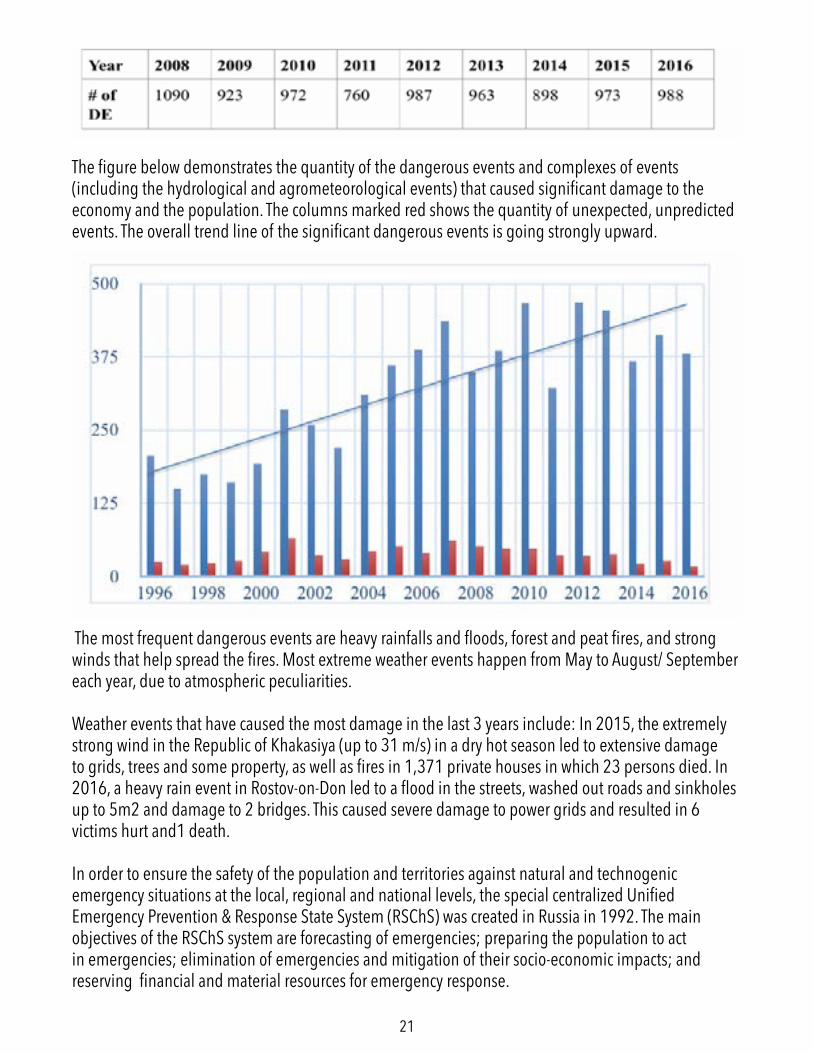
21
The figure below demonstrates the quantity of the dangerous events and complexes of events (including the hydrological and agrometeorological events) that caused significant damage to the economy and the population. The columns marked red shows the quantity of unexpected, unpredicted events. The overall trend line of the significant dangerous events is going strongly upward.
The most frequent dangerous events are heavy rainfalls and floods, forest and peat fires, and strong winds that help spread the fires. Most extreme weather events happen from May to August/ September each year, due to atmospheric peculiarities.
Weather events that have caused the most damage in the last 3 years include: In 2015, the extremely strong wind in the Republic of Khakasiya (up to 31 m/s) in a dry hot season led to extensive damage to grids, trees and some property, as well as fires in 1,371 private houses in which 23 persons died. In 2016, a heavy rain event in Rostov-on-Don led to a flood in the streets, washed out roads and sinkholes up to 5m2 and damage to 2 bridges. This caused severe damage to power grids and resulted in 6 victims hurt and1 death.
In order to ensure the safety of the population and territories against natural and technogenic emergency situations at the local, regional and national levels, the special centralized Unified Emergency Prevention & Response State System (RSChS) was created in Russia in 1992. The main objectives of the RSChS system are forecasting of emergencies; preparing the population to act in emergencies; elimination of emergencies and mitigation of their socio-economic impacts; and reserving financial and material resources for emergency response.
22
SAUDI ARABIASubmitted by Climate Scorecard Country Manager ABEER ABDULKAREEM
Extreme Rainfall and Flash Flooding in Jeddah City
In 2009 and 2011, Jeddah City in the middle of the western region of Saudi Arabia experienced short, but intense rainfall events with rainfall precipitation values of 70 mml and 110 mml that led to flash floods. The World Bank climate adaptation expert, Balgis Osman-Elasha, defines an extreme rainfall event as one with “an intense rainfall and high quantities of rain (more than 90 millimeters) over a short span of time (four hours) over an area that normally receives 45 millimeters per year.” These flash floods had catastrophic consequences resulting in the death of 113 people in 2009 and damage to 10,000 houses and to 17,000 vehicles.
When analyzing the factors that led to the flash floods, rainfall and climate change factors played a major role contributing to the worsening of the flood disaster. Youssef et al.’s study in 2015 indicates a direct correlation between the magnitude and frequency of intense rainfall events and climate change. This result was reached by conducting a frequency analysis in which the maximum daily rainfall amount corresponding to a set of return periods of 25, 50, 100, and 200 years were calculated for the Jeddah city to determine the temporal effect of climate change on rainfall characteristics. These effects can include an increase or decrease in precipitation. A study using time-series data and descriptive statistics were used to determine the temporal trend in rainfall data and found a trend slope of 0.35, with a Pearson’s correlation coefficient (r) of 0.16, with a p-value of 0.36. These results indicate a moderate positive correlation of the annual maximum rainfall with increasing time. Based on this result, the precipitation was increased by about 27.8%. Thus, the study showed that the rainfall values changes and the increasing number of rainfall events are consequences of climatic changes. Many of the policy changes are in the form of recommendations such as conducting a detailed hydrological study of the recently-constructed human settlements that are along watercourses and at outlets downstream of wadis (valleys), and establishing a flash flood warning system for all areas that are subjected to flash floods.
Learn More
Climate Change to hit Saudi’s Agriculture, Waterhttp://www.scidev.net/global/desert-science/news/climate-change-to-hit-saudi-s-agriculture-water.html
Ahmed M. Youssef, Saleh A. Sefry, Biswajeet Pradhan & Emad Abu Alfadail (2016) Analysis on causes of flash flood in Jeddah city (Kingdom of Saudi Arabia) of 2009 and 2011 using multi-sensor remote sensing data and GIS, Geomatics, Natural Hazards and Risk, 7:3, 1018-1042, DOI: 10.1080/19475705.2015.1012750 http://www.tandfonline.com/doi/pdf/10.1080/19475705.2015.1012750
23
SOUTH AFRICASubmitted by Climate Scorecard Country Manager LEE-ANN STEENKAMP
Severe Country-Wide Drought
The current drought, which started in the summer of 2014, is the third-driest for South Africa as a whole since the early 1930s when the country was hit by a historic drought in the midst of the Great Depression. The severity of the current drought has been aggravated by an El Nino, a weather pattern which decreases moisture in the sub-Saharan region.
Many financial hubs in the country, including Cape Town and Johannesburg, had to impose water restrictions on residents. Dry conditions last year cut South Africa's maize crop by a third. South African livestock farmers were urged by the government to cut the size of their herds as drought conditions suck moisture out of grazing land.
Response
The continued low rainfall resulted in very dry conditions with drought being reported in all nine provinces of the country. As a result, eight of the provinces were declared as disaster areas, thereby authorising the release of crucial funds to assist farmers. However, it recently came to light in Parliament that more than R380 million (about US$28.6 million) which could have been used to assist farmers during the drought, has not been spent. This is due to mismanagement by the Department of Cooperative Governance and Traditional Affairs, which had not informed any stakeholders that the money was still available.
Other support provided to affected communities and farmers included the identification of land for relocation of livestock‚ revitalisation of feedlots‚ auction sales of livestock‚ provision of feed and water for livestock‚ support to small-holder farmers and sugar cane farmers and the creation of firebreaks. Fodder banks were established in rural areas and animal feed was delivered to farmers as part of efforts to maintain livestock.
On March 5, 2017, the mayor declared the City of Cape Town a disaster area, in order to respond more rapidly by mobilising staff and resources to deal with the crisis. The city's dwindling water supply is predicted to run out in little more than 100 days if dam levels and water consumption remain unchanged. The critically low water supply was further put under pressure by wildfires in the Western Cape area, caused by the dry and windy summer season.
Future Actions
South Africa is a water-stressed country and is on an economic growth pathway that is very water
24
intensive. In order to meet the increased water and food demands of a growing population, a collective effort by government, farmers and private industry is required. We have to learn best-practices from other drought-challenged countries in adapting to the ever-worsening weather conditions.
Learn More
For ongoing updates on the current drought in South Africa, see: http://www.droughtsa.org.za/faq.html
The South African Water Research Commission supports sustainable water development: http://www.wrc.org.za/
The Weather Service provides information on the types of droughts that South Africa experiences: http://www.weathersa.co.za/learning/climate-questions/36-what-kind-of-droughts-does-south-africa-experience
To understand more about the impact of the current drought on the South African economy, see: http://www.businessleadership.org.za/newsletter-content/The-impact-of-the-current-drought-on-the-South-African-economy/index.html?&re=1
SOUTH KOREASubmitted by Climate Scorecard Country Manager EUNJUNG LIM
2016 Extreme Heat Wave
The recent extreme heat wave in 2016 caused extensive damage to people, the environment and to the country as a whole. The damage can be seen in the agricultural sector, the maritime-fisheries sector, the environment/energy sector and on people’s health.
Damage to the agricultural sector included death of livestock and plants because of the high temperatures that were above 32 degrees Celsius. The repair costs for these damages were over 2,000 million KRW. The government tried to deal with these agricultural sector problems by introducing policies and actions such as providing information on the analysis of agricultural climate characteristics, climate damage by agro-climatic zones, and forecasting each region’s soil moisture status (167 cities and counties).
The most significant damage to the maritime-fisheries sector was that aquaculture species died as a result of the high-water temperatures that cost 50 billion KRW. The government issued warnings and breaking news on low/high water temperatures to help the aquaculture industry prevent the massive
25
death of fish (this was also a reaction from the cold waves in 2015 and 2016).
Due to these heat waves in Seoul, which lasted for 24 days, including 32 days of tropical nights, national ozone warnings were issued on a regular basis. During this period, electricity consumption reached its peak, 8,370,000 kW. This high demand for electricity resulted in the rapid increase of sales of air conditioners (160% increase), dehumidifiers (245% increase), and electric fans (92% increase). As a policy response, the National Institute of Environmental Research and NASA developed a joint air quality investigation.
The heat waves also affected people’s health. In 2016, the number of patients with thermal problems (heat stroke) doubled. In order to monitor such health issues, the Korean Centers for Disease Control and Prevention now provides the current status of health damages and releases news on the rapid increase in the number of patients with thermal conditions/problems.
SPAINSubmitted by Climate Scorecard Country Manager ANDREA DELMAR-SENTIES
Extreme Droughts and Floods in Eastern and Southern Spain
Extreme weather has ravaged Spain in the last couple of years. Torrential rains and deadly floods plagued eastern and southern Spain in December of 2016 resulting in ten fatalities, school and highway closures, and massive amounts of damage. Conversely, Spain experienced extreme droughts in 2016 and 2014, where rainfall was only 25% of its normal levels. In June 2015, Spain experienced heat waves with some provinces reaching record temperatures. With such chaotic weather patterns, Spain’s economy has suffered, its population is uneasy, and the government has struggled to keep up with remedial measures.
While Spain frequently experiences dry spells, extended periods of drought have become more frequent and more severe. In recent years, Spain’s reservoirs have fallen to half or even 25% of their normal levels. The droughts have negatively impacted Spain’s economy since they hinder the ability to grow crops or raise livestock and deter tourism, which are some of Spain’s leading sources of income. Furthermore, Spain may find itself in a similar situation as it was during the drought of 2008, which was so severe that Spain was forced to import fresh water from France.
In December 2016, extreme flooding ravaged southern and eastern Spain. The region experienced days of endless rainfall that caused damage to buildings, infrastructure, and cars. The flooding claimed the lives of ten people, including one man who was swept out to sea. These floods led to speculation that rising sea levels due to global warming may have exacerbated the flood conditions.
26
As a result of the flooding, the Spanish government will be providing financial assistance to aid in reparations. While this measure will benefit many citizens who suffered damages in the floods, it does nothing to prevent future flooding. Additionally, the Spanish government is still recovering from its recent economic crisis. Providing this financial assistance will pose a further financial burden on the government. The reservoirs and dams that exist in Spain today were built during the dictatorship of Francisco Franco roughly half a century ago. The Spanish government may find that investing in the creation of new dams and reservoirs could prevent future flooding while also providing more sources of fresh water during periods of drought.
Learn More
http://www.thelocal.es/20161219/emergency-measures-in-place-as-torrential-rain-makes-spanish-rivers-overflow
http://www.independent.co.uk/news/world/europe/spains-drought-a-glimpse-of-our-future-833587.html
http://www.theolivepress.es/spain-news/2014/05/25/worst-drought-in-150-years-hits-spain/
THAILANDSubmitted by Climate Scorecard Country Manager NEEBIR BANERJEE
Extreme Rainfall and Flooding
A recent example of climate change related extreme weather in Thailand happened in December 2016. Twelve of Thailand’s 14 southern provinces experienced heavy rainfall that lasted for several days. The excessive rainfall led to massive flooding and devastation in these provinces and other regions including central Thailand, areas of the Malay Peninsula, and northern Indonesia. Narathiwat, the southernmost province in Thailand experienced around 226 mm (almost 9 inches) of rainfall in the first two days of December. This flooding event led to significant disruption in rail services in the surrounding area. It damaged around 2,400 hectares of farmlands and more than 360,000 people were severely affected, and approximately 14 deaths occurred. In response to the widespread flooding, the Governor of Thailand’s Surat Thani province identified 16 of the province’s 19 disaster areas; and small boats and vessels were warned not to venture to sea. Heavy rainfall still continued for several days, which increased the risks of landslides and flash floods.
27
Government policy-makers have expressed an urgent need for the implementation of disaster management policies, which incorporates flood management. However, residents from flood-prone communities have strongly opposed the manner through which these flood management measures has been proposed by the Thai government. One such flood management measure is the construction of flood protection walls, which is associated with growing debates from both sides. To address the necessity of constructing the flood protection walls, Pattanan Thongsawad, a demonstrator and local resident of Thailand’s flood prone village Yucharoen, argued, “We want more concrete walls all the way around our community. That is the only way I’ll feel secure. There will be more rain and more floods and we cannot rely on the government to deal with them”. In contrast, Gernot Laganda, a climate specialist at the United Nations Development Program Office in Bangkok highlighted the cons of building a flood protection wall by arguing, “It will be more important to build strong monitoring systems and to start building climate flexible systems. Instead of building high walls and river defenses today, it will make more sense to strengthen the foundations of existing structures so they can be raised as and when risks become more apparent.” Similarly, Surajit Chirawate, who sits on the senate environmental committee, argues about the cons of constructing a flood protection wall by saying, “People should not fight with the water. They should let it through. That is how we dealt with floods in the past. That is why Bangkok has so many canals. But now rich city dwellers are too distant from nature. What they are doing with their flood protection walls is actually increasing the level of the water”. Such debates are leading to increased uncertainties about the effectiveness of policies in place with respect to flood management measures. Therefore, Thailand still has a long road ahead for implementing an effective natural disaster management and flood control policy that will be successful in the long-run. Developing such policies will require a more transparent process, which can be achieved through joint collaboration between the residents from vulnerable flood-prone communities, citizens, Thai Government, policymakers, environmental planners and concerned stakeholders.
Learn More
To learn more about the recent flooding event in Thailand, which occurred in December 2016, please visit http://www.air-worldwide.com/Blog/Floods-in-Thailand-Are-Regular-Natural-Disasters/
To learn more about the 2011 flooding in Thailand, the flood management measures proposed by the government post-2011 flooding and the growing debates associated with these measures, please visit http://www.climatecentral.org/news/partner-news/thailand-seeks-flood-prevention-plan-as-bangkok-clean-up-operation-con
28
TURKEYSubmitted by Climate Scorecard Country Manager OZLEM DUYAN
Extreme Rainfall in the Black Sea Region
In June 2016, Ordu, a coastal city in the Black Sea Region of Turkey, faced an extreme weather condi-tion. A heavy rainfall of 300 kg per square meter resulted in a terrible disaster and loss of life. Land-slides occurred in 16 regions that caused the destruction of many houses and bridges. Coastal roads were also closed to traffic due to landslides.
While deforestation increased the catastrophic consequences, improper construction techniques played a major role in this specific disaster. An old bridge built in 1940 was not demolished, but the bridge that was built ten years ago together with new retaining walls was demolished. Several newly built houses were submerged. The main reason for this is that the new buildings and bridges have been constructed on the waterway without a proper soil survey. Also when agriculture was common in the region, the cultivated areas had waterways that resulted in a gradual flow. As agricultural activities decreased, these waterways could not find an offset such as street gutter.
After the incident, the construction permits in the risky areas have been revoked. However the existing buildings have not been evacuated yet which paves the way for similar disasters occurring in the future. The precautions to be taken in the region as well as the improvements made after the catastrophe are insufficient. After almost a year, the demolished bridges and retaining walls have not yet been repaired. It is necessary to take action without losing time in order to prevent similar incidents in the Black Sea Region.
29
2015-2016 UK Floods
December 2015 in the UK was the second wettest December there since records began. A complete lack of frost, and a temperature that was 4.1 degrees above average, resulted in huge amounts of rainfall being dropped within a 24-hour window. Large swathes of the north of England and Scotland received on average 5.9 inches of rainfall – with some areas of Cumbria even recording 13.4 inches. Gusts of up to 115 mph were frequent, and two more storms quickly followed: both depositing even heavier rainfall on already-saturated landscapes. Multiple rivers broke their banks, a bridge collapsed and gas pipes were ruptured. Over 16,000 homes and businesses were flooded, many more suffered prolonged power-cuts, and dozens of rescue missions had to be undertaken by boat to save stranded residents.
It is clear that these storms, and the subsequent flooding, were weather events far outside the normal reaches of the British climate, and it is highly probable that it was influenced by climate change. Climate change has caused a rise in global temperatures that has resulted in the air within the Pacific and Atlantic jet streams being warmer. This in turn has enabled the air streams to hold more water vapor and thus increase the likelihood of extreme rainfall and flooding when they hit land. Dame Silgo, chief scientist at the Met Office, stated that just ‘from a basic physical understanding of weather systems, it is entirely plausible that climate change has exacerbated what has been a period of very wet and stormy weather.’
The sitting Conservative government received a lot of criticism for not heeding previous flood warnings and for cutting flood defense spending when it was most needed. In 2014, the Met Office advised the government that Britain was in line for more heavy rainfall events due to climate change, and that funding cuts would leave 240,000 households at greater risk of flood damage within 20 years. Nevertheless, with deficit reduction being prioritized over addressing climate change-related risks, the promised £400m per year for flood defense spending was cut sharply each year: £360m in 2010-11, to less than £270m in 2012-13. Funding was, on average, 37% lower than the funds provided by the previous government.
Following the storms, a raft of policies was announced to mitigate the immediate impacts, and to ensure long-term flood protection. Government figures state that over £200 million has been spent in extra investment for storm recovery. Local authorities were provided with £500 for each household affected, and £2,500 for each business. Households were provided with grants of up to £5,000 to install flood barriers, replace doors and windows with water-resistant alternatives and to move electricity sockets to safer levels. Flood affected communities would be exempt from Council Tax
UNITED KINGDOMSubmitted by Climate Scorecard Country Manager ADAM BARNETT
30
and business rate bills while they were out of their properties, and farmers could get grants of up to £20,000 to help restore damaged agricultural land. £40 million was pledged to help repair flood-damaged roads and bridges, and an additional £10 million was given to the Environmental Agency to repair and improve flood defenses. The government agreed to match every donation made by the public to support flood efforts up to £2 million, as well as pledging to invest a total of £2.3 billion in flood defenses over the next 6 years.
Opposition parties criticized this reaction as a ‘sticking-plaster response’, noting that the proposals mainly included funding that was already destined for such projects, and that the total earmarked was not enough to fully prepare for, and adapt to, future climate-change related extreme weather events.
Learn More
http://www.independent.co.uk/environment/uk-weather-why-the-recent-devastating-floods-will-become-the-new-normal-a6793291.html
https://www.theguardian.com/environment/2015/dec/30/experts-criticise-george-osborne-over-flood-protection-funding
https://www.gov.uk/government/news/north-west-england-floods-2015-government-response
UNITED STATESSubmitted by Climate Scorecard Country ManagerSTEPHANIE GAGNON
Drought in the State of California
Since 2012, California has suffered from a drought that reached its peak in the years 2014-2017. Characterized as an extended dry period caused by lack of precipitation and/or reduction in groundwater, the drought came at a tremendous cost to California and other surrounding states. In 2015 alone, it is estimated that the drought cost the state US$2.7 billion, largely in lost agricultural productivity and employment. Additionally, the drought increased the severity of wildfires and floods, destroying millions of trees and billions of dollars worth of property. As of early 2017, the drought has largely ended in northern California, but parts remain under extreme drought conditions in southern California.
While it is difficult to link individual weather events to climate change, researchers at Stanford University have suggested reduced atmospheric pressure—and subsequent reduced precipitation—as the root cause of the drought. They suggest that such a severe drought would not have occurred to
31
the same extent without global climate change caused by the burning of fossil fuels. Another study connected increased global average temperatures from climate change with greater soil moisture evaporation, which increased the severity of the drought.
While the drought emergency has not yet been lifted by governor Jerry Brown, it is expected to be lifted within the next six weeks. Despite the hardship the state endured over the past five years, water policy has not improved as much as necessary to protect the state in the event of another drought like this one. However, water usage in the state remains greatly reduced from pre-drought levels, and monitoring and reporting practices are in the process of being made permanent fixtures of California law.
Learn More
Costs of the drought in 2015:http://www.usatoday.com/story/weather/2015/08/19/california-drought-cost-27-billion-2015/32007967/
Studies linking drought and climate change:http://news.stanford.edu/news/2014/september/drought-climate-change-092914.html
https://thinkprogress.org/how-much-of-californias-drought-was-caused-by-climate-change-scientists-now-have-the-answer-56ae9e33555f#.amp1gp8nh
Post-drought outlook for California:https://www.nytimes.com/2017/03/10/us/california-drought-snowpack.html?_r=0
32
ABOUT
HOW IT WORKS
Climate Scorecard is a participatory, transparent, and open data effort to engage all concerned citizens in supporting the implementation of the new 2015 Global Climate Agreement.
Background
Over 190 countries endorsed a new global climate agreement in December 2015 at a United Nations meeting in Paris (known as COP21). The Paris Agreement is designed to stabilize the earth’s climate and prevent our atmosphere from heating-up above a global warming tipping point of 2 degrees Celsius, beyond which scientists warn extreme ecological disasters will occur. The success of the new agreement is contingent on the efforts all countries, as well as non-state actors, must make to increase and honor their commitments to reduce greenhouse gas emissions.
In 2015, in preparation for COP 21, most countries submitted pledges, also known as Intended Nationally Determined Contributions (INDCs), to reduce their greenhouse gas emissions by 2030 or earlier. The Paris Agreement recognizes that these pledges, while good starting points, are insufficient to avoid having the planet warm beyond 2 degrees Celsius. Therefore, all countries are encouraged to revisit and strengthen their pledges before the agreement goes into effect in 2020.
Climate Scorecard is a mechanism for supporting efforts needed to implement the new Paris Agreement. Such efforts include encouraging countries to increase their emission reduction pledges, tracking efforts to strengthen pre-Paris INDCs, making sure that countries put in place policies and programs to achieve their reduction targets, and holding nation-states accountable for fulfilling the promise of the Paris Agreement.
The Climate Scorecard team has established a website - www.climatescorecard.org - where everyone – citizens, organizations, businesses, researchers, members of governments, journalists – can share information related to emission reduction efforts in the top 25 greenhouse gas-emitting countries. Each of the 25 top greenhouse gas emitting countries has a page on our website where concerned stakeholders can post information related to the status of their country’s pledge. Climate Scorecard’s website also provides a set of 6 targeted results (see below) that we believe each country needs to achieve by 2020 in order to successfully implement the new Paris Agreement. These results are based on recommendations from the agreement itself, benchmark country emission reduction pledges, and our own research that has identified goals that all countries need to reach. Our targeted results provide a framework for tracking progress made by the top 25 greenhouse gas-emitting countries.
33
WHO WE ARE
Results for the Top 25 Greenhouse Gas-Emitting Countries to Achieve by 2020
• Strengthens its 2015 agreement pledge, or adheres to a pledge that meets Result 3 in the Framework• Agrees and implements measures to reach the target of 20% unconditional emission reduction by 2020• Agrees and implements measures to reach the target of 30% unconditional emission reduction by 2025• Adopts the UN suggested baseline year of 2010 from which to calculate future reductions• Agrees to and implements policies that achieve 100% renewable energy by 2050• Make all aspects of its emission reduction process, including policy development and implementation, transparent and inclusive
An outstanding team of organizations and individuals is implementing Climate Scorecard. Coordination of our effort is through a partnership between The Global Citizens’ Initiative (TGCI) and EarthAction- non-profit organizations with missions focused on environmental protection and citizen engagement. TGCI and EarthAction worked together to successfully implement last year’s Citizens’ Campaign for a 2015 Global Climate Agreement (www.climateagreementcampaign.org).
TGCI and Earth Action have recruited a team of 25 environmental graduate students and young professionals who serve as Country Managers, building and supporting networks of organizations and people to contribute and share information related to the post-Paris progress of each of the top 25 greenhouse gas-emitting countries.
In addition, university-based experts provide quality control and address technical questions related to documents that are proposed for posting on the Climate Scorecard website.
For further information about Climate Scorecard please contact Ron Israel, Executive Director, The Global Citizens’ Initiative ([email protected]) or Lois Barber, Executive Director, EarthAction ([email protected]).