Embed Size (px)
Citation preview

IAEA-TECDOC-1463
Recent developments in uraniumexploration, production and
environmental issuesProceedings of a technical meeting organized by the
IAEA in cooperation with theOECD Nuclear Energy Agency and DIAMO State Owned Enterprise
held in Straz, Czech Republic, 6–8 September 2004
September 2005

IAEA-TECDOC-1463
Recent developments in uraniumexploration, production and
environmental issuesProceedings of a technical meeting organized by the
IAEA in cooperation with theOECD Nuclear Energy Agency and DIAMO State Owned Enterprise
held in Straz, Czech Republic, 6–8 September 2004
September 2005

The originating Section of this publication in the IAEA was:
Nuclear Fuel Cycle and Waste Technology Section International Atomic Energy Agency
Wagramer Strasse 5 P.O. Box 100
A-1400 Vienna, Austria
RECENT DEVELOPMENTS IN URANIUM EXPLORATION, PRODUCTION AND ENVIRONMENTAL ISSUES
IAEA, VIENNA, 2005 IAEA-TECDOC-1463 ISBN 92–0–108005–0
ISSN 1011–4289 © IAEA, 2005
Printed by the IAEA in Austria September 2005

FOREWORD
The worldwide uranium production industry is at a crossroads. At a time when the market price has doubled in the past two years, uranium production and exploration have nearly ceased in Europe, as operations have shut down in response to high production costs and depletion of reserves. By contrast, new operations elsewhere in the world are being developed or expanded to meet the growing demand for newly mined and processed uranium (primary supply).
The technical meeting, which was hosted by DIAMO, State-owned Enterprise, in Stráz-pod-Ralskem, Czech Republic, was attended by 24 participants from 15 countries. The meeting was purposely given a broad scope, “Recent Developments in Uranium Exploration, Production and Environmental Issues”, to reflect the diversity of activities and issues currently facing the uranium production industry. The participants presented 11 papers covering a diverse range of topics including deposit geology, project licensing requirements, research on production methods, production site rehabilitation and uranium supply and demand relationships. The European participants, reflecting the closing of the continent’s uranium mines and mills, placed emphasis on rehabilitation and decommissioning of uranium production facilities. By contrast, developing countries placed emphasis on expanding or restarting their uranium production capability.
In addition to presentation of the technical papers, the participants had an opportunity to visit the Rozná mine in the Czech Republic, two WISMUT rehabilitation projects — the Helmsdorf tailings pond and the Königstein mine in Germany and the Stráz ISL and underground mine rehabilitation projects near Stráz-pod-Ralskem. The Rozná mine is scheduled to shut down in 2005. Therefore, the visit to this production centre gave an opportunity to visit an operating mine and mill and to review plans for rehabilitation of the production complex, some of which are already being implemented. The WISMUT site visits provided the participants with an opportunity to observe application of state of the art rehabilitation technology being utilized at the largest uranium production site rehabilitation effort in the world.
This report provides insights into an industry in transition. It provides technical information on efforts under way in developing countries to renew or expand uranium production capacity as a way to ensure a source of fuel for their nuclear power programmes. Papers are presented on new project licensing, demand for and availability of uranium resources and research on extraction technology for low-grade uranium resources. It also provides value technical insights into state of the art technology being used in uranium production site rehabilitation. Case histories of site rehabilitation included in this report provide valuable references for companies or governments that are either planning for or are currently involved in site rehabilitation. The paper on uranium supply and demand provides an overview of the uranium market at the time of the meeting and gives insights into reasons for the recent market price increase. It also provides background information on the adequacy of primary and secondary uranium supply sources to meet projected demand.
The IAEA is grateful to all participants who contributed papers and in particular to J.M. McMurray, consultant, who was responsible for organizing the meeting and finalizing this publication. Special thanks are due J. Slezák of DIAMO, who helped organize the meetings and site visits. The IAEA officer responsible for this publication was C. Ganguly of the Division of Nuclear Fuel Cycle and Waste Technology.

EDITORIAL NOTE
The papers in these proceedings are reproduced as submitted by the authors and have not undergone rigorous editorial review by the IAEA.
The views expressed do not necessarily reflect those of the IAEA, the governments of the nominating Member States or the nominating organizations.
The use of particular designations of countries or territories does not imply any judgement by the publisher, the IAEA, as to the legal status of such countries or territories, of their authorities and institutions or of the delimitation of their boundaries.
The mention of names of specific companies or products (whether or not indicated as registered) does not imply any intention to infringe proprietary rights, nor should it be construed as an endorsement or recommendation on the part of the IAEA.
The authors are responsible for having obtained the necessary permission for the IAEA to reproduce, translate or use material from sources already protected by copyrights.

CONTENTS
SUMMARY .............................................................................................................................. 1
Licensing new uranium production projects in Argentina ........................................................ 3 P.R. Navarra
Demand and availability of uranium resources in India ........................................................... 7 A.B. Awati, R.B. Grover
Development of China’s hard rock uranium resources: Supporting technology and research ..................................................................................................... 17 Zeng Yijun, Zuo Jianwei
Status and results of the WISMUT environmental remediation project ................................. 21 M. Hagen, A.T. Jakubick, M. Paul
Re-contouring and final covering of the Trünzig and Culmitzsch tailings ponds at WISMUT ............................................................................................................. 33 U. Barnekow, A. Neudert, U. Hoepfner
Problems and solutions for water treatment at the closed Hungarian uranium industry................................................................................................ 41 G. Erdi-Krausz
Remediation of tailings Ponds I and II .................................................................................... 45 G. Folding, G. Nemeth
Legal aspects of uranium mining and milling in the Czech Republic .................................... 53 J. Horyna
Uranium exploration restarted in Niger ................................................................................... 59 A. Ousmane
The relationship between the uranium market price and supply-demand relationships .......... 63 J.M. McMurray
Site Visits to Rozná, Wismut and Stráz ................................................................................... 73 J.M. McMurray
LIST OF PARTICIPANTS ..................................................................................................... 79


SUMMARY
The Technical Meeting on Recent Developments in Uranium Exploration, Production and Environmental Issues, was held in Stráz-pod-Ralskem, Czech Republic from 6 to 8 September 2004. The meeting was preceded by site visits to the Rozná mine in the Czech Republic and the Helmsdorf tailings pond and the Königstein mine in Germany from 1–4 September. Meeting participants also had an opportunity to visit various mine and in situ leach (ISL) rehabilitation sites in the area around Stráz.
Background
The title of the meeting was intentionally broad to reflect the diversity of the uranium production industry in various parts of the world, and the range of papers reflected this broad scope. Many developing countries are striving for self-sufficiency in their uranium production capabilities. Accordingly, they presented papers on a range of topics including uranium exploration, project licensing, and research directed towards improving uranium production efficiency and costs. Papers presented by participants from Europe emphasized uranium site rehabilitation, reflecting the fact that uranium production has all but ceased in Europe. These papers described site remediation technology that is being utilized at a variety of sites ranging from tailings ponds to mine water treatment plants. The recent rapid increase in the uranium market price has dominated discussions among uranium producers and users alike. Not surprisingly the price increase was also a much-discussed topic at this Technical Meeting. One paper reviewed the reasons for the rapid price increase and the relationship between market price and uranium supply-demand relationships.
Uranium geology and exploration
Uranium production is likely to become more important to Niger’s economy if the recent price increase is sustainable. Accordingly, Niger’s uranium production companies have initiated uranium exploration to increase resources associated with current operations and to confirm the potential of other known deposits and regional exploration trends. Niger exports all of its uranium so market price and project economics are important factors to its uranium industry. By contrast, all of India’s uranium production is dedicated to its domestic nuclear power programme. Though uranium production is less sensitive to production economics, India is nevertheless emphasizing exploration in geologic environments that have the potential to host large, high-grade deposits with the potential for lower production costs. To ensure self-sufficiency in the near term, India is also developing new production capability in a variety of geologic environments with well-established resources, but with lower grades and capacity potential.
Project licensing and environmental regulations
The recent market price increase has made projected production costs for two of Argentina’s uranium projects more competitive in the marketplace. Before re-starting existing projects or developing new projects, however, Argentina’s production company, CNEA, must acquire a number of mining permits and licenses. To ensure that its projects gain public and regulatory approval, CNEA has implemented programmes that emphasize technology that will ensure that its proposed operations meet regulatory requirements. It has also initiated a public relations programme to demonstrate the environmental compatibility of its projects to affected communities.
1

Uranium mining and processing and site rehabilitation in the Czech Republic are closely monitored by the State Office for Nuclear Safety (SÚJB). The oversight responsibilities of SÚJB and the body of law that ensures its authority are presented in paper that may be useful to countries with emerging nuclear industries.
Uranium production technology
Approximately 80% of China’s uranium resource base is hosted in hard rock geologic environments, mainly in vein deposits in granites and volcanic complexes. These resources occur mainly in small, low-grade deposits with high production costs. Accordingly, China has implemented research on ways to better develop its hard rock resource base. This research has concentrated on improving technology for heap leaching of low-grade uranium ore as a way to improve recovery and lower production costs.
Rehabilitation of uranium production facilities
As uranium production in Europe has declined, emphasis has turned to rehabilitation of former production facilities. Examples of rehabilitation projects in Germany and Hungary describe the range of problems that must be addressed and the state of the art technology that is being employed to solve serious environmental impacts of uranium production. Site visits to WISMUT rehabilitation sites in Germany and the Rozná mine in the Czech Republic gave meeting participants an opportunity to see first hand how rehabilitation technology is being successfully applied in areas with serious environmental impact.
The relationship between market price and uranium supply and demand
Uranium supply and demand are affected by a diversity of factors including market price, availability of secondary supply, production capacity, uranium resources and opposition to uranium mining. In the concluding paper of the meeting, the interrelationships among these various issues are discussed as they relate to the future balance between uranium supply and demand.
2
LICENSING NEW URANIUM PRODUCTION PROJECTS IN ARGENTINA
P.R. NAVARRA Comisión Nacional de Energía Atómica, CNEA, Argentina
Abstract. Due to the decision to complete construction and begin operation of the Atucha II Plant, Argentina’s nuclear reactor fuel requirements will increase in the mid-term from 120 tU/year to 220 tU/year. Current market conditions justify reactivation of indigenous production of uranium concentrates that could progressively replace imports. Consequently, CNEA presented to the Mendoza Province and national (Nuclear Regulatory Authority) licensing authorities a proposal for reactivation of the San Rafael Mining-Milling Complex. The main step in the licensing process is the Environmental Impact Assessment (EIA). This includes both assessment of the engineering for remediation of waste generated during previous production activities, and of environmental management of future production activities. The EIA was carried out by the National Technological University. The Cerro Solo Project, Chubut Province, which is currently at the pre-feasibility stage, is being considered for initiation of the feasibility study and development-production stage. Under present market conditions, the estimated project production cost has become competitive, and the resources of the project could be sufficient to supply the long-term needs of Argentina’s nuclear power plants. Taking into account the increasing interest in environmental issues, and stricter environmental regulations, the main challenges to re-activation of uranium production in Argentina are: improvement of interaction with local communities; training of skilled personnel in waste management; and developing cost estimates and plans for mine-mill closure.
1. Introduction
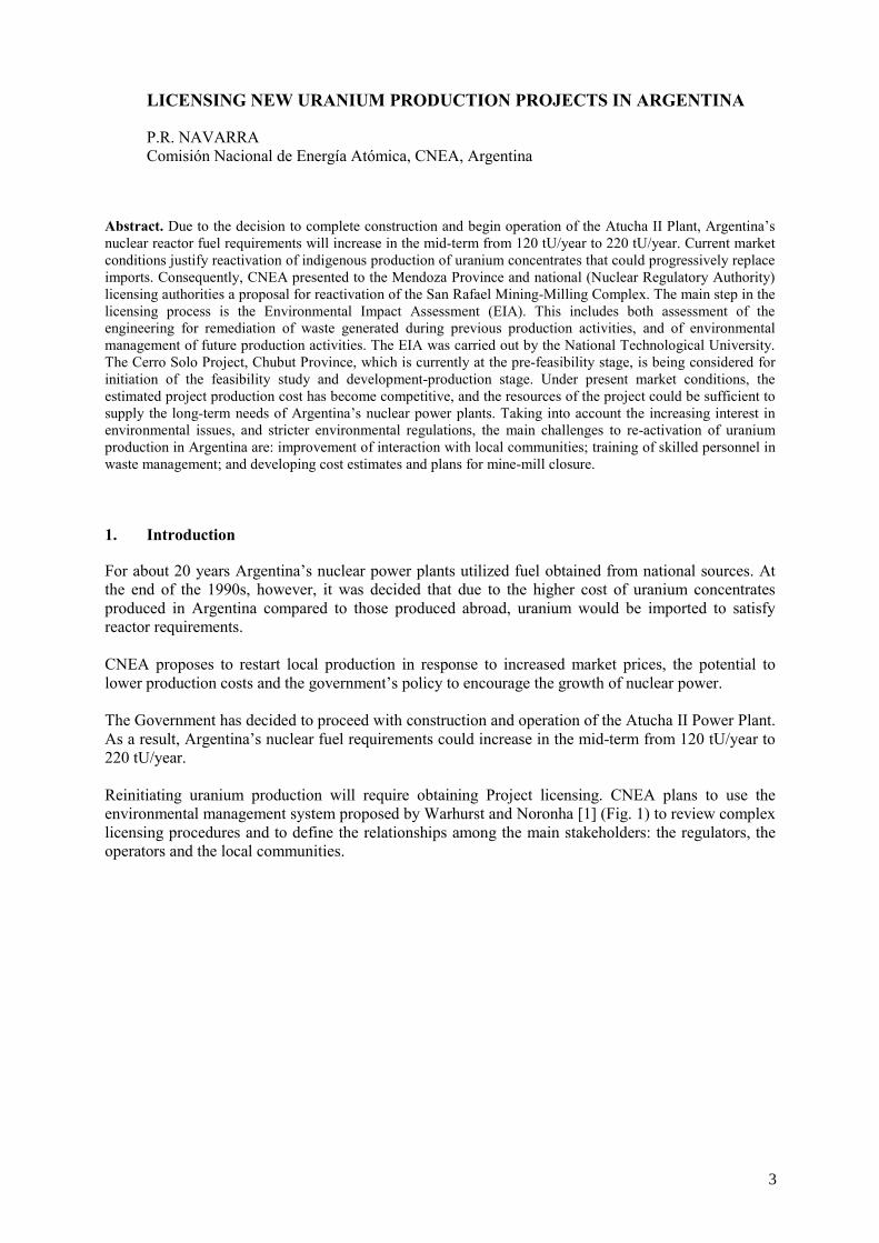
For about 20 years Argentina’s nuclear power plants utilized fuel obtained from national sources. At the end of the 1990s, however, it was decided that due to the higher cost of uranium concentrates produced in Argentina compared to those produced abroad, uranium would be imported to satisfy reactor requirements. CNEA proposes to restart local production in response to increased market prices, the potential to lower production costs and the government’s policy to encourage the growth of nuclear power. The Government has decided to proceed with construction and operation of the Atucha II Power Plant. As a result, Argentina’s nuclear fuel requirements could increase in the mid-term from 120 tU/year to 220 tU/year. Reinitiating uranium production will require obtaining Project licensing. CNEA plans to use the environmental management system proposed by Warhurst and Noronha [1] (Fig. 1) to review complex licensing procedures and to define the relationships among the main stakeholders: the regulators, the operators and the local communities.
3
FIG. 1. Environmental management system.
1.1. Licensing stakeholders 1.1.1. Regulations An important first step in the licensing process is to fully understand the government’s policies towards mining activity. The government’s goal is to promote development of mining activities under proposed environmental laws that are comparable to those in the rest of Latin America. At the same time, the Government is promoting use of nuclear power due to the deficit of energy supply from other sources, which is a key factor for economic growth and a positive development for the uranium mining industry. Reform of Argentina’s natural resource development policies began ten years ago with the launch of a new policy to promote mining production and to create a new legal framework with comprehensive environmental control to support it. This reform gave rise to enactment of the Mining Environmental Law 24585, which has proved to be an efficient tool to facilitate the approval of different mining projects while taking into consideration both production and environmental concerns. Uranium mining is also considered in Act 24804 for Nuclear Activity, which establishes the competence and role of the Nuclear Regulation Authority with regards to radiological safety.
STAKEHOLDERS
• Local communities • Operator
- employees - suppliers - clients - shareholders - related institutions
• Regulators
IMPLEMENTATION
EIA-Audits • Environmental policy • Environmental training • Environmental management • Monitoring • Emergency response • Rehabilitation plan • Hazardous materials management • Plan for closure • Plan for post-closure
- Future land use
MINING OPERATION supported by:
INVESTMENT TECHNOLOGY
HUMAN RESOURCES
ENVIRONMENT — Social — Land — Air — Water
— Biodiversity
4

The Environmental Impact Assessment must be approved by the local authorities of each province as established by Law No. 24585. Thus, these authorities become responsible for controling the environmental impact of a project. 1.1.2. The operators Licensing of mining activities has become controversial in Argentina, largely because of concerns raised over past mining practices. However, in order to offset public concern, mining companies in Argentina are making an effort to demonstrate good operating practices, transparency and better flow of information about their plans and operations. CNEA, at present Argentina’s only uranium mining company, is using information from uranium operations in other countries to improve its environmental management practices. A group of professionals trained in waste remediation and decommisioning of different closed sites, is working on new CNEA production projects. These projects will utilize the most up to date methodology to control environmental impact in two ways: first, by implementing safe and environmentally sound production methodology; and second, by ensuring that operating practices will minimize long-term impact and closure costs. The costs of project closure and remediation will be re-evaluated on an ongoing basis and will be included in overall project economics. Measures have already been taken to improve the flow of communication with the populations that will be affected by proposed mining operations both as to operating and project closure plans. 1.1.3. The attitude in local communities In general, local communities realize how important mining production is for economic growth at both the local and national levels. There is also a positive attitude among a majority of the population towards the need for nuclear power in Argentina’s overall energy mix. However, there are groups that continue to oppose new uranium exploitation projects largely due to a lack of knowledge, which generates fear of the risks of mining and nuclear activities. Therefore, information and education about uranium mining remains an important part of CNEA’s public relations programme. 2. The projects 2.1. The San Rafael mining-milling complex remediation and reactivation project CNEA has presented a proposal to reactivate the San Rafael Mining-Milling Complex to the Mendoza Provincial and national (Nuclear Regulatory Authority) licensing authorities. The main step of the licensing process is the Environmental Impact Assessment (EIA), that includes both an assessment of the engineering design for remediation of wastes generated by past production activities, and of environmental management of future production activities. The EIA was carried out by the National Technological University, Avellaneda Regional Department, in collaboration with DBE TEC, a German consulting company, and with local institutions. The EIA was completed after two years of intensive work to gather baseline data on key environmental components, and to assess environmental risks. An important goal of the EIA was to resolve concerns the community had with regards to existing mining and processing wastes that are under transitory management, and concerns about reactivation of uranium mining and processing activities. The studies carried out concluded that the former operations had neither affected the quality of the underground and surface water of the area, nor any other component of the environment of the region. CNEA’s project proposal includes remediation of the existing wastes. This remediation can be prior to or simultaneous with resumption of production operations. Resumption of operations will be accompanied by substantial improvements in environmental protection practices.
5

The feasibility of the project is based on re-evaluation of the main ore deposit, and on changes in mineral treatment methodology, which allow an important reduction in production costs. Project economics also incorporate final closure and remediation costs. 2.2. The Cerro Solo project CNEA is considering reinitiating work on a feasibility study for the Cerro Solo deposit, which is located in Chubut Province. Cerro Solo is a uranium-molybdenum sandstone deposit with estimated resources of 5 000 tonnes U (Reasonably Assured Resources and Additional Estimated Resources) at an average grade of 0.3% U. There is also potential to increase Cerro Solo resources by exploration in the surrounding area. The ore, which lies at a depth of between 50 and 120 metres, would be extracted by a combination of open pit and underground mining methods.
The Cerro Solo project is currently at the pre-feasibility stage. However, because of increased market prices, production costs at Cerro Solo could be competitive in the world market. This potential has led CNEA to consider proceeding with the Cerro Solo feasibility study. If development of Cerro Solo proves to be economic, its production could be sufficient to supply Argentina’s near- to mid-term reactor fuel requirements. 3. Conclusions CNEA, in response to increased interest in environmental issues and stricter environmental regulations, has increased the level of environmental awareness throughout its organization. As it considers re-activation of production at the San Rafael mine-mill complex and potential development of the Cerro Solo project, CNEA is committed to incorporating environmental best practices into its future operations by the following actions:
• Improving environmental awareness throughout the organization must begin at the management level. The costs of project closure and rehabilitation must be included in overall project economics. Therefore, the culture of environmental awareness will include the understanding at all levels of the organization that environmental best practices during operations help ensure lower closure and rehabilitation costs and, therefore, improve overall project economics.
• Local support for uranium production operations is best gained by transparency of operating and closure plans. Only when it understands the operator’s commitment to environmental protection and proper closure and rehabilitation plans can the public be expected to support future development of Argentina’s uranium mining industry.
REFERENCES
[1] WARHURST, A., NORONHA, L., Corporate strategy and viable future land use: planning for closure from the outset of mining. Natural Resources Forum 24, p. 153–164, Pergamon (2000).
[2] OECD NUCLEAR ENERGY AGENCY, Uranium 2003, Resources, Production and Demand, A Joint OECD/NEA-IAEA publication (2004).
6

DEMAND AND AVAILABILITY OF URANIUM RESOURCES IN INDIA
A.B. AWATI, R.B. GROVER Department of Atomic Energy, Mumbai, India
Abstract. To ensure long-term energy security, India has chosen to follow a “closed nuclear fuel cycle” approach and accordingly formulated a three-stage nuclear power programme. The first stage, based on the use of natural uranium, comprises setting up of Pressurised Heavy Water Reactors (PHWRs) and associated fuel cycle facilities, and is already in the industrial domain. The second and third stages envisage setting up of Fast Breeder Reactors (FBRs) and thorium based reactors, respectively. India’s identified uranium resources can meet the requirements of about 10 GWe installed electric generation capacity of PHWRs operating at a lifetime capacity factor of 80% for 40 years. These resources, with some exceptions, are of low-grade (less than 0.10% U3O8) resulting in relatively higher cost of production. In spite of these higher uranium production costs, the cost of nuclear power in India compares well with other options. Uranium production is solely linked to the national programme and therefore, mining activity is not market sensitive. Considering the growing demand for uranium and the high cost of production, there is an urgent need to locate high-grade, large tonnage deposits that could be exploited at lower cost and would also sustain production for a longer time. Accordingly exploration activities are being focused on select thrust areas of Proterozoic basins and on Cretaceous sandstones considered to have the best likelihood for discovery of economically attractive deposits. At the same time, new mines and production centers are being opened to meet the increased uranium demand. Efforts are also being made to reduce uranium production costs from low-grade ore.
1. Introduction
India, home to over one sixth of the world’s population, has been witnessing an impressive economic growth. Forecasts indicate that growth of the Indian economy will continue during the 21st century. The strong correlation between per capita gross domestic product and per capita electricity consumption is well known. Therefore growth in the economy has to be accompanied by growth in electricity generation.
India’s total installed electricity generation capacity, which was only 1363 MWe in 1947, rose to 30 214 MWe in 1980-81, to 66 086 MWe in 1990-91 and to 136 973 MWe as on 31st March 2003. One recent forecast indicates that total installed electricity capacity in India from all sources of energy could reach 1350 GWe in about five decades [1]. Electricity generation of this magnitude calls for careful examination of all issues related to sustainability, including available energy sources and technologies, security of supplies, self sufficiency, security of energy infrastructure, effect on local, regional and global environments and demand side management.
India’s energy mix comprises coal, oil and natural gas, hydro, nuclear and non-conventional generation technology. Nuclear energy could play important short-term and long-term roles in India. One estimate indicates that nuclear capacity may grow to 275 GWe by the middle of the century accounting for a 25% share in electricity generation.
India has developed expertise in every aspect of nuclear technology and is in a position to undertake a major expansion of its nuclear power programme. Accordingly the Department of Atomic Energy has formulated a programme for increasing the installed nuclear capacity. The programme envisages developing about 20 000 MWe installed capacity by 2020, of which 10 000 MWe will be based on natural uranium fuelled Pressurised Heavy Water Reactors (PHWRs). New constructions will lead to increased uranium demand.
This paper briefly presents India’s nuclear power programme and reviews demand and supply of uranium resources, the impact of increasing demand on availability of uranium resources and future exploration and mining strategies to meet the projected demand.
7

2. Nuclear power programme
At the Geneva International Conference on Peaceful Uses of Atomic Energy in August 1955, in his Presidential address, Homi J. Bhabha, founder of the Indian nuclear energy programme, emphasized [2] “for the full industrialization of the under-developed countries, for the continuation of our civilisation and its further development, atomic energy is not merely an aid, it is an absolute necessity. The acquisition by man of the knowledge of how to release and use atomic energy must be recognized as the third epoch of human history”.
To ensure the long-term energy security Bhabha and his colleagues reviewed India’s nuclear resource potential, and formulated a three-stage nuclear power programme [3, 4]. This programme follows a “closed nuclear fuel cycle” approach with a view to ultimately utilizing abundant thorium resources available in the country. The first stage of the nuclear power programme consists of constructing natural uranium fuelled Pressurized Heavy Water Reactors (PHWRs) and associated fuel cycle facilities. The second stage envisages constructing Fast Breeder Reactors (FBRs) and the third stage will be based on the thorium-uranium-233 cycle.
In parallel, other proven technologies such as Light Water Reactors (LWR) have been introduced as an addition to the indigenous power programme described above, in order to accelerate capacity additions and thus to increase the share of nuclear power. The Department of Atomic Energy (DAE) has sought to set up Light Water Reactors (LWR) based on imported technology that conform to the latest safety standards and should be economically attractive [5, 6]. Two Boiling Water Reactors (BWRs) have been constructed at Tarapur, Maharashtra, in collaboration with U.S.A. Presently two units of 1000 MWe each of the VVER type reactor are under construction in collaboration with the Russian Federation, at Kudankulam, Tamil Nadu.
There are 14 nuclear power reactors in India comprising 12 PHWRs and 2 BWRs with total installed capacity of 2.8 GWe. The medium-term plan is to increase installed nuclear capacity to about 20 GWe by the year 2020, which would account for about 7% of the projected total installed electrical generating capacity in the country at that time. Presently nine nuclear power reactors of different types and sizes are under various stages of construction. These include six PHWRs, two VVERs, and one Prototype FBR (PFBR). Within a period of 3-4 years, India will achieve installed capacity of about 4460 MWe with PHWRs, the mainstay of the first stage of the indigenous nuclear power programme and another 2320 MWe with Light Water Reactors (LWRs) reaching a cumulative capacity of around 6780 MWe [7]. Future additions of PHWRs will be based on a review of India’s uranium resource position. Details of the projected nuclear power programme through 2020 are given in Table I and the cumulative capacity build up is given in Figure 1.
A study carried out in the DAE presents a scenario, indicating that the cumulative installed nuclear power capacity would grow to around 275 GWe by the middle of the century (Fig. 2) [1]. This capacity buildup would account for nearly 20% of the total installed electrical generating capacity at that time and will be achieved predominantly by FBRs.
8

Table I. Projected nuclear power programme upto 2020
Reactor Type
Present capacity Under Construction Planned Total capacity by 2020 in MWe
PHWR 2500 (12 reactors at 5 sites: Rawatbhata, Kalpakkam, Narora, Kakrapar and Kaiga)
1960 Tarapur (2×540 MWe) Kaiga (2×220 MWe) RAPS (2×220 MWe)
5600 (8×700)
10060
LWR 320 (2×160MWe) 2000 (2×1000 MWe) VVER
6000 (6×1000)
8320
PFBR/ FBR
--- 500 (1×500 MWe) PFBR 2000 (4×500)
2500
AHWR --- --- 300 (1×300)
300
Note: Installed capacity in MWe
4460 44604460
7260
10060678067808280
15380
21180
30402500
33602820
0
5000
10000
15000
20000
25000
Year
MW
e
PHWR Projected PHWR Total Projected total
2004-05 2005-06 2008-09 2010-11 2015-16 2020-21
FIG. 1. Nuclear power capacity buildup upto 2020.
3. Uranium resources
A number of small to medium sized uranium deposits have been discovered in India in different geological environments and structural settings. The majority of these deposits are low-grade, having less than 0.10% U3O8 as an average grade. These deposits are located in the Proterozoic and Phanerozoic basins and mainly occur in three uranium provinces, Singhbhum Shear Zone, Jharkhand; Cuddapah basin, Andhra Pradesh, and Cretaceous Mahadek Formation, Meghalaya [8, 9, 10 and 11]. Important Proterozoic and Phanerozoic basins hosting uranium deposits and those identified as target areas for uranium exploration are shown in Figure 3.
9

FIG. 2. Projected installed power capacity (after R.B. Grover & S. Chandra, 2004).
The arcuate Proterozoic Singhbhum Shear Zone (also known as Singhbhum Thrust Belt) is traceable for about 200 km length from Lotapahar in the west to Baharagora in south-east in the Singhbhum Province of eastern India. The Singhbhum Shear Zone hosts more than 14 major uranium deposits accounting for about 60% of the known Indian resources. The mineralization is vein/disseminated type, polymetallic and located along the tectonized northern and eastern margin of the Singhbhum craton.
Sandstone type uranium mineralisation occurs mainly in the Cretaceous Mahadek sandstones in Meghalaya and the Siwalik formations along the northwest Sub-Himalayan foothills. Of these the Upper Cretaceous Mahadek sandstone occurring along the southern fringe of the Meghalaya Plateau in northeastern India has been established as one of the most potential sources for uranium. The deposits located at Domiasiat, Wahkyn and Tyrnai occur at a shallow depth below the surface and are amenable to open cast mining. The average grade of these deposits is 0.10% U3O8.
Many of the Proterozoic basins of India exhibit favourable geological settings for hosting possible unconformity-related mineralisation. The Cuddapah, Bhima, Chattisgarh, and Vindhyan basins, are all considered to have potential. Other basins of significance are Indravati, Palnad, Kunjar, Gwalior and Shillong. Exploration efforts, during the past two decades have resulted in establishing low-grade, medium tonnage uranium deposits at Lambapur-Peddagattu in the northern margin of the Cuddapah
2.72
29
63
131
275138.73
417
648954
1344
1
10
100
1000
10000
2002 2022 2032 2042 2052YEAR
POW
ER (G
We)
Nuclear Total
10

basin where mineralisation is associated with chloritised biotite granite and gritty quartzite adjacent to the unconformity that separates the two rock types.
FIG. 3. Important Proterozic and Phanerozoic Basins of India as target areas for uranium exploration.
Strata bound uranium mineralisation hosted by impure phosphatic dolostone of the Vempalle Formation of the Papaghni Group occurs along the southwestern part of the Middle Proterozoic Cuddapah basin. Uranium occurs along bedding planes mainly in the form of ultra fine vanadium-bearing pitchblende and U-Si-Ti complex. Low-grade, medium sized deposits have been established at Tummalapalle, Rachakuntapalle and Gadankipalle. Large potential for low-grade uranium resources exists in this setting.
The in situ uranium resources of India, in the RAR, EAR-I and EAR-II categories are estimated to be about 95 500 tonnes U. Speculative resources are over and above these resources. Intensive
11

exploration efforts are underway to upgrade EAR-II resources and to convert Speculative Resources to a higher category so that these resources could become available for the nuclear power programme. The total resources [12, 13] grouped in different categories are given in Table II.
Table II. Uranium resources
Resource Category tU3O8 tU
RAR 64 400 54 600
EAR-I 29 800 25 300
EAR-II 18 300 15 500
Speculative Resources 20 000 17 000
4. Adequacy of available resources
India’s goal is to achieve self-sufficiency in uranium resources in order to support its presently envisaged natural uranium based nuclear power programme as well as future requirements. The present indigenous nuclear power plants are of the pressurized Heavy Water Reactor (PHWR) type having heavy water as a moderator and coolant, and working on the once-through-cycle of natural uranium fuel. Based on identified in situ uranium resources after accounting for various losses due to mining, milling and fabrication, the net uranium available for power generation would be over 61 000 tonnes [12]. When used in the PHWRs these resources can produce nearly 330 GWe-year electricity. This is equivalent to about 10 GWe installed capacity of PHWRs operating at a life time capacity factor of 80% for 40 years.
Two operating BWRs are fuelled by imported enriched uranium as will be two units of VVER type reactors that are under construction. Imported LWRs are based on assurance of fuel supply for the lifetime of the plant.
As India has adopted a policy of a “closed nuclear fuel cycle”, the spent fuel is reprocessed to recover plutonium-239 and uranium-238. Plutonium will be used as a fuel in the FBRs in the second stage of the planned nuclear programme along with depleted uranium recovered by reprocessing spent fuel from the first stage. In FBRs, in addition to generating electricity, more plutonium will be generated by conversion of uranium-238 to plutonium-239. Spent fuel is thus a valuable resource for the nuclear power programme. The electricity generating potential by FBRs with the uranium thus recovered is equivalent to about 530 GWe capacity for 100 years [1].
5. Production capability and future plans
Uranium production in India commenced in 1968 by Uranium Corporation of India (UCIL), a State owned Public Sector Undertaking. Until recently, UCIL was operating three underground mines at Jaduguda, Bhatin, and Narwapahar in Singhbhum East district of Jharkhand in the eastern part of the country. During 2003 a new underground mine was opened at Turamdih in the Singhbhum East district. Ore from these four mines is treated at the Jaduguda processing plant, which has an installed capacity of about 2100 tonnes of ore per day.
In addition to these conventional operations, UCIL operated three uranium recovery plants at Rakha, Surda and Mosabani to recover uranium from copper tailings as a by-product of copper mining in Singhbhum belt. However, these operations have been temporarily suspended due to scaling down of copper mining in the area.
12

Uranium demand and supply are currently in balance in India. Supply is maintained from new production and drawdown from the accumulated stockpiles. However, in view of the new power plant construction (PHWRs), uranium requirements are expected to increase. The annual requirements, which includes actual demand upto 2010 and projected requirements upto 2020 are presented in Figure 4.
504
880
1380
465
1880
0
500
1000
1500
2000
2003-04 2005-06 2010-11 2015-16 2020-21
Year
tUO
2
FIG. 4. Annual uranium requirement trend. Opening of new uranium mines and construction of uranium ore processing plants are time-consuming activities and under normal circumstances require 4-5 years time from planning to production stage. Advance actions are, therefore, required to be initiated including preparation of a feasibility report, choosing the proper consultant, preparation of a detailed project report (DPR), carrying out EIA/EMP studies, preparation of a mining plan, acquisition of land and obtaining various clearances such as a mining lease, forest clearance, environmental clearances, explosives licence, Government approval etc. Considering future demand and in view of the time consuming activities listed above, new mines and processing plants have been planned in different parts of the country and will be commissioned in a phased manner so as to produce uranium commensurate with demand. Ore processing capacity is planned to be enhanced substantially. In Singhbhum East district, in addition to the existing four mines, two new mines are planned. The uranium deposit located at Banduhurang, in the vicinity of Turamdih, is planned to be mined by the open-pit method. Both the deposits at Turamdih and Banduhurang occur in similar geological setting and contain a total of about 9000 tonnes of uranium oxide. An ore processing plant to process the ore from both these mines is being constructed at Turamdih with an installed capacity of about 3000 t ore/day. Another deposit located at Bagjata in the southern part of the Singhbhum Shear Zone, where exploratory mining was carried out earlier, is also under consideration for exploitation. In addition, two important deposits outside Singhbhum area that have been planned for mining are located at Lambapur-Peddagattu, in the northwestern part of the Cuddapah Basin in Andhra Pradesh, and at Domiasiat in the West Khasi Hills of Meghalaya. Ore from these mines will be processed in processing plants to be constructed at the respective mining areas with installed capacity of 1250 t ore/day and 1500 t ore/day. Uranium production in India is solely linked to the national programme and as such mining activity is not market sensitive. The cost of uranium production is high because of the low-grade deposits.
13

However, in spite of the high cost of uranium production, the cost of nuclear power in India compares well with other options. Uranium production from deposits with lower production costs and higher tonnage is given the highest priority. However, various factors play a role in decision making and include not only grade and tonnage of the deposit but also possible recovery rate, available infrastructure, accessibility of the deposit and environmental constraints. Additional demand would be met by progressively opening other mines / production centers with matching or marginally higher costs of production. RAR and EAR-I category resources satisfy these criteria. Other resources would be considered subsequently depending on their viability and the need. Secondary uranium resources are unconventional resources and comprise uranium bearing materials, which are generated as co- or by-products, liquid or solid waste, residues, slag, scraps etc. Exploitation of such secondary resources is another area of importance. Given the higher cost of uranium in India, this option works out to be very attractive in contrast with the situation in the rest of the world. R&D efforts are being mobilized to access this important energy resource [14].
6. Exploration strategy
India’s policy is to continue to define and develop uranium resources to meet its national requirements. Notwithstanding the fact that available resources are adequate to meet the envisaged demand for 10 000 MWe capacity PHWRs, there is need to locate high-grade, large tonnage and low cost uranium deposits and augment its resources considerably to displace the dependency on relatively high-cost and low-grade deposits. Considering India’s growing future demands and greater security of supply associated with low-cost uranium, thrust areas have been identified for extensive exploration. The important thrust areas include the Meso-Neoproterozoic Cuddapah basin, Andhra Pradesh; Proterozoic Aravalli-Delhi basins, Rajasthan; Neoproterozoic Bhima basin, Karnataka; and Cretaceous Mahadek sandstone, Meghalaya. Detailed description on the mineralisation in these four areas has been given in the Red Book 2003 [13]. The present exploration strategy includes development of geological models and employment of a multidisciplinary and multi-phased approach including indirect methods of exploration to identify concealed deposits in the selected thrust areas. These efforts are being supported by a substantial increase in drilling activities. In addition, research and development work has been initiated to increase the recovery of uranium from low-grade and large tonnage deposits at lower costs.
7. Concluding remarks
Nuclear power is a well-established technology in India where the first stage of the power programme based on PHWRs is already in the commercial domain and the second stage has been launched with the start of the excavation in 2003 for constructing FBRs. As development of the nuclear power programme accelerates, the concomitant demand for fuel will also increase. There is a need to plan additional PHWRs beyond 2020 and also to consider extending reactor life beyond 40 years. Although India’s available uranium resources are adequate for presently operating and future PHWRs with a total installed capacity of 10 000 MWe for 40 year lifetimes, it is necessary to identify high-grade, large tonnage uranium deposits to meet future demands and to displace current dependency on low-grade deposits. Among the important pre-requisites for achieving this goal will be extensive Research and Development to locate significant low-cost additional uranium resources, and to develop technology for maximizing recovery and the best possible utilization of known resources. Considering these facts and for locating additional resources, a strategy has been developed for uranium exploration, which comprises extensive exploration programmes in selected thrust areas. In this context both direct and indirect methods of exploration are being employed, which are supported
14

by substantial drilling activities. The selected Proterozoic basins and Mahadek sandstones have good potential for discovery of new uranium deposits, so it is expected that exploration in these areas will result in substantial augmentation of uranium resources.
ACKNOWLEDGEMENTS
The authors are grateful to Dr. Anil Kakodkar, Chairman, Atomic Energy Commission for fruitful discussions and his keen interest in carrying out analysis on a demand and supply scenario of nuclear fuel resources.
REFERENCES
[1] GROVER, R.B., SUBHASH CHANDRA., A strategy for growth of electrical energy in India,
Document No.10, August, 2004, Department of Atomic Energy, Mumbai, India (2004). [2] BHABHA, H.J., Presidential Address, International Conference on the Peaceful Uses of
Atomic Energy, Geneva (1955). [3] BHABHA, H.J., The need for atomic energy in the under-developed countries, Evening
Lecture at the Second International Conference on the Peaceful Uses of Atomic Energy, Geneva, (1958).
[4] BHABHA, H.J., PRASAD, N.B., The study of contribution of atomic energy to a power programme in India, Second International Conference on the Peaceful Uses of Atomic Energy, Geneva (1958).
[5] Nuclear Energy in India - A perspective (2000), Indian National Academy of Engineering, New Delhi (2000).
[6] KAKODKAR, A., Nuclear Power in India: An inevitable option for sustainable development of a sixth of humanity, World Nuclear Association Annual Symposium, September 4-6, 2002, London (2002).
[7] KAKODKAR, A., GROVER, R., (2000), Nuclear Energy in India, The Nuclear Engineer, Volume 45, No.2 (2000).
[8] SINHA, K.K., DAS, A.K., SINHA, R.M., UPADHYAY, L.D., PANDEY, P., SHAH, V.L., Uranium and associated copper-nickel-molybdenum mineralization in the Singhbhum shear zone, Bihar, India: present status and exploration strategy, Exploration and Research for Atomic Minerals, Vol. 3, p 27-43 (1990).
[9] MAHADEVAN, T.M., Identifying high-grade uranium deposits in the Proterozoic basins of India- a challenge to exploration, Exploration and Research for Atomic Minerals, Vol. 8, p 49–60 (1995).
[10] SINHA, R.M., SHRIVASTAVA, V.K., SARMA, G.V.G., PARTHASARATHY, T.N., (1995), Geological favourability for unconformity related uranium deposits in northern parts of the Cuddapah Basin: evidences from Lambapur uranium occurrence, Andhra Pradesh, India, Exploration and Research for Atomic Minerals, Vol. 8, p 111-126 (1995).
[11] SEN, D.B., SACHAN, A.S., PADHI, A.K., MATHUR, S.K., Uranium exploration in the Cretaceous Mahadek sediments of the Meghalaya Plateau, Exploration and Research for Atomic Minerals, Vol. 14, p 29–58, (2002).
[12] AWATI, A.B., Internal Note, Department of Atomic Energy, Government of India, (2003). [13] OECD NUCLEAR ENERGY AGENCY, Uranium 2003: Resources, Production and Demand,
A Joint Report by the OECD Nuclear Energy Agency and the International Atomic Energy Agency, (2004).
[14] KAKODKAR, A., Emerging dimensions of our nuclear fuel cycle programme, In Nuclear Fuel Cycle Technologies: Closing the fuel cycle, INSAC-2003, Proceedings of Annual Conference of Indian Nuclear Society, Kalpakkam, India (2003).
15


DEVELOPMENT OF CHINA’S HARD ROCK URANIUM RESOURCES: SUPPORTING TECHNOLOGY AND RESEARCH
ZENG YIJUNa, ZUO JIANWEIb a Beijing Research Institute of Chemical Engineering and Metallurgy, China b China Nuclear Uranium Corporation, CNNC, China
Abstract. In support of the development of China’s nuclear power industry, further technical research work is being conducted on hard rock uranium resources. The characteristics of China’s hard rock uranium resources, which account for about 80% of the country’s resource base, are briefly introduced. Research on uranium extraction from hard rock resources, with special emphasis on heap leaching technology, has the potential to lower production costs for a significant part of China’s hard rock resource base.
1. Introduction
With the development of China’s Nuclear Power Industry, increased quantitites of natural uranium resources are required. China prefers to satisfy this growing demand dominantly by domestic production.
Expansion of China’s uranium production capacity will require efficient development of its uranium resources. Uranium mining and metallurgical technology must be improved in order to convert Reasonably Assured Resources (RAR) into mineable resources. Improved production economics, including reduction of capital and operating costs will necessitate the application of new technology, equipment and material.
Since 1990, a series of investigations on China’s hard rock uranium resources has led to development of new technology, which has expanded China’s exploitable hard rock uranium resources. Capital and operating costs of China’s natural uranium production have also been reduced.
Research results on heap leaching, percolation leaching and in place leaching have contributed to the improvement of China’s natural uranium production economics. In addition, exploitable hard rock uranium resources have been expanded as a result of this research.
2. Uranium deposit types in China
Known uranium resources in China occur in the following deposit types:
(a) Vein deposits in granite, (b) Volcanic, (c) Sandstone, (d) Black shale (carbonareous-siliceous pelites).
3. Necessity of further research on China hard rock uranium resources
Uranium demand in China can potentially be satisfied in three ways:
(a) Domestic production. (b) Resource exploitation abroad. (c) Purchase from the international uranium market.
Among the above, domestic production is the preferred option. Hard rock uranium resources account for more than 80% of China’s total uranium resource base. The most important approach for
17

increasing China’s uranium capacity is to develop heap leaching technology for its hard rock uranium deposits. Advances in heap leaching technology have the potential to improve hard rock production costs and thus increase utilization of China’s hard rock uranium resources.
4. The characteristics of China’s hard rock uranium resources
Small and disseminated deposit
China’s hard rock uranium deposits are typically small, and are expensive to develop on a unit cost basis (USD/kgU).
Low-grade, complicated mineralogy and paragenetic elements
Uranium in most hard rock deposit is associated with other paragenetic elements, which in combination with complex wall rock and gangue mineralogy, complicate heap leaching by increasing reagent consumption and creating difficulties in separation and purification. These complications in turn increase production costs.
Ore depth and unstable lithology
Open-pit mining is generally not suitable for China’s hard rock deposits due to their depth. Poor ground conditions in some of the underground mines contribute to increased mining costs. 5. Technical developments in the field of uranium extraction from hard rock resources
Because of the diversity of China’s uranium resources, various processing technologies have been researched and applied since the beginning of its uranium extraction industry. China has utilized some unique technology such as direct production of ammonium uranyl tricarbonate from leaching solutions and extraction of uranium from lignite ash. However, through the end of the 1990s most of China’s uranium products have been produced by conventional agitated leaching. High capital costs, complex operations, and high consumption of energy and materials associated with conventional leaching have impeded further development of China’s uranium extraction industry. After a few decades’ effort, Chinese technical personnel have made breakthroughs in heap leaching duration, recovery, and leachant consumption. Techniques for waste treatment and uranium bearing solution purification have also improved. These improvements in technology have increased utilization of heap leaching on hard rock uranium resources in China. 6. Research achievements on uranium extraction from hard rock resources in China Breakthroughs in heap leaching techniques for hard rock uranium resources have led to such desirable results such as reduction of capital and operating costs, improvement of productivity and product quality and extending the availability of economically viable hard rock uranium resources. Several mines which were to be shut down have continued to operate after implementing innovative heap leaching techniques. Currently operating mines perform better economically using heap leaching techniques. Heap leaching, percolation leaching or in place stope leaching are now being used in all of China’s mines, except for the Xinjiang Region where in situ leaching is employed. Some of the commercially applied heap leaching technology for hard rock uranium extraction is listed in Table I.
18

Table I. Commercially applied heap leaching technology used for hard rock uranium extraction
No. Item Effect
1. Heap leaching with small sized ore particles
Leaching duration and recovery are dramatically improved
2. Serial heap leaching Leachant consumption decreases by 10%, concentration of uranium bearing leaching liquor is increased from 1g/L to 5–8g/L
3. Acid curing-ferric heap leaching Leaching duration decreases from 200d to 80d
4. Agglomerated heap leaching of poor permeable ores
Leaching duration of clay-rich ores decreases from 200d to 60d, recovery is increased from 40% to 95%
5. Bacterial heap leaching Duration decreases below 90d, acid consumption decreases by 15–20%
6. Zero discharge effluents from uranium extraction mill
The zero discharge of extraction process waste water is realized and the radioactive contaminants level released into the environment is dramatically reduced
7. New precipitation approach Reagent consumption decreases, moisture content of yellowcake decreases from 60% down to 30%
8. Stope leaching of blasted ores The amounts and cost of hoisted ores decrease, the radioactive contamination to the surface is alleviated greatly
9. Activated heap leaching Recovery increases by 10% and leaching duration decreases by 30–50%
10. Heap leaching of U-Mo paragentic materials
Leaching duration is 50-60d, recovery of uranium 90%, molybdenum, 80%
7. Future research tasks on hard rock uranium extraction in China Assessment of hard rock uranium resources in China With improvements in heap leaching technology, it is necessary to reassess China’s hard rock uranium resources and to perform feasibility studies for exploitation of these resources.
Research on the mining techniques for hard rock uranium deposits
Due to their depth, relatively low-grade and complex mineralogy, it is much more difficult to exploit hard rock uranium resources in China than in many other parts of the world. Since mining costs account for a large percentage of total production costs, research is underway to develop technology for extraction of low-grade ore.
Investigations on the pretreatment of hard rock ores
Pretreatment of ores including dehydration of clay-rich ores, ore crushing and ore sorting are important for lowering the cost of uranium extraction.
19

Technical research on uranium leaching and recovery
Extraction of common uranium minerals has been the main focus of research in China. However, other resources such as complex uranium minerals containing phosphorous, vanadium, sulphur, uranothorite, and even coal, are expected to be researched in the future.
8. The target prospects of extractive technology on hard rock uranium ores in China
Research on hard rock mining and extractive metallurgy will be applied to the evaluation of China’s hard rock resources. Given the fact that 80% of China’s total resource base is in hard rock deposits, new technology, particularly that focused on heap leaching, will be the key to expanding China’s production capacity and improving its overall production economics.
20

STATUS AND RESULTS OF THE WISMUT ENVIRONMENTAL REMEDIATION PROJECT
M. HAGEN, A.T. JAKUBICK, M. PAUL WISMUT GmbH, Chemnitz, Germany
Abstract. More than 216 000 metric tons of U have been produced in Eastern Germany between 1945 and the reunification of Germany. The mining, milling and processing activities affected an area of approximately 100 km2. Following reunification, € 6.6 billion were committed to remediation of the liabilities and Wismut GmbH has been entrusted with the implementation of the task. The inventory of this legacy comprises the full scope of mining liabilities: Operations areas (37 km2), five (5) large underground mines, an open pit mine (100 M m3), waste rock dumps (311 M m3) and tailings (160 M m3). The associated specific activities are 0.5 to 1 Bq/g for the waste rock, 10 Bq/g for the tailings, up to 500 Bq/g for the water treatment residues and 0.2 to 1 Bq/g for scrap metal. A specific feature of the remedial preparation is that the individual remedial measures are based on object specific environmental assessment (Remedial Investigation/Feasibility Studies, RI/FS) rather than on uniformly regulated limits, thus tailoring the extent of remediation to the scale of the problem (or risk). The remedial strategy in case of vulnerable objects, such as a tailings pond is selected by means of a probabilistic risk assessment. The selection of a particular remedial design and prioritization of the sequence of remedial measures for an object/site with complex interactions is based on a Conceptual Site Models (CSM) approach. The remedial solutions and concepts applied at Wismut sites have been developed within an international context; yearly international workshops and meetings of the Uranium Mine Remediation Exchange Group (UMREG) an inter-institutional discussion platform for the topical problems of remediation. The physical work is implemented in 14 projects coordinated from 3 on site Management Units (Ronneburg, Aue and Königstein). The strategic direction, feedback, optimization and specialists support is provided from the Head Office in Chemnitz. The contaminated seepage to be treated at Wismut varies over a wide range: Small volumes come from waste rock piles (1 to 30 m3/h), up to hundreds m3/h from the supernatant water of the tailings ponds and discharges of 50 m3/h to 1000 m3/h from the mines. To replace the regular water treatment plants in the long term, a number of alternative water treatment technologies are tested currently. The remediation/reclamation of the Wismut objects is now up to more than 60% complete. A number of remediated areas and objects have been turned over to communities and found use as part of the regional/communal development projects.
1. Origin of the WISMUT environmental rehabilitation project
After World War II, eastern Germany (former GDR) was the scene of large-scale uranium mining supplying the Soviet Union with the feed material in the first 25 years for the nuclear armament and later on also nuclear energy programs. The mining, milling and processing activities took place within a relatively small but densely populated area in Thuringia (154 inhabitants per km2) and Saxony (247 inhabitants per km2). The affected area extends from East to West approximately 130 km and from North to South approximately 50 km. More than 216 500 metric tons of U have been produced in Eastern Germany from 1945 until reunification of Germany in 1990.
This production made SDAG Wismut rank third (after U.S. and Canada) in comparison with other uranium-producing countries.
In 1990 the uranium production was abandoned due to exhaustion of ore deposits and lack of economic viability. The complex structure of SDAG Wismut was split into several lines of business. The business units (branches) not instrumental to the future core business of remediation were gradually privatized. After this fundamental corporate restructuring, WISMUT GmbH was established by federal law (WISMUT Act, 1991) and put in charge of decommissioning and rehabilitating the uranium mining liabilities. Federal funds totaling up to Euro 6.5 billion (DM 13 billion) were committed to this project. In the light of a reappraisal of the extent to which the cleanup was to be taken and experience gained, the rehabilitation costs were reassessed to Euro 6.2 billion in 2000. Wismut's remediation assignment includes objects under ground (mine workings, pit shafts, surface openings, near-surface workings) and above ground (buildings/structures, mine dumps, the Lichtenberg open pit mine, tailings ponds and operations areas) located at five mining sites (Ronneburg, Aue, Pöhla, Königstein, Gittersee) and two milling and processing sites (Seelingstädt and
21

Crossen). The period required to complete the rehabilitation project was estimated to be at least 15 years.
Basically, the boundary conditions of the decommissioning and rehabilitation process are set by the Federal Mining Law, the Atomic Energy Act (in particular the Radiation Protection Ordinance), and the Water Resources Management Act. The remedial solutions and concepts applied at Wismut had been developed within an international context; yearly international workshops and meetings of the UMREG group provided a discussion platform and sounding board for the topical problems and envisaged solutions.
The physical work is implemented in 14 projects coordinated from 3 on site Management Units (Ronneburg, Aue and Königstein). The strategic direction, feedback, optimization and specialists support is provided from the Head Office in Chemnitz.
2. Risk potential of the mining liabilities
An initial assessment of the degree of contamination of the affected areas was based on dose rate measurements done in a 50×50 m grid collecting a total of approximately 238 600 measurement points. The data collected during 1991 – 1993 were stored in an environmental database (register). Based on this survey, approx. 85% of the surveyed territory were released for unrestricted use because the measured dose rates were near background level of 200 nSv/h.
The inventory of the SDAG Wismut legacy comprises the full scope of mining liabilities. In 1990 they included:
• 37 km2 operational areas; • 5 underground mines: Schlema, Pöhla, Königstein, Gittersee, Ronneburg representing a volume of
1.53 M m3 and 1,470 km of tunnels and drifts to be cleaned; • An open pit mine with a volume of 84 M m3 at Lichtenberg/Ronneburg; • 311 M m3 of waste rock piled up in 48 mine dumps containing an inventory of 20 000 t U and
having a specific activity of 0.2...2 Bq/g (Ra-226); the radionuclide vector is approximately in equilibrium; the potential exposure pathway is by emanation of radon;
• 178 M m3 of tailings (in Seelingstädt and Crossen) disposed in impoundments having a total surface of 5.7 km2; the specific Ra-226 activity in tailings is approximately 10 Bq/g; the radionuclide vector is typically in disequilibrium; the potential exposure pathway is by dusting of long-lived alpha emitters attached to dust.
Common to all these legacies is the presence of radiological (carcinogenic) risk. In addition, the waste rocks and tailings originating from the Ore Mountains (Erzgebirge) contain substantial amounts of arsenic. In Ronneburg, the acid mine drainage (typically pH = 2.5 to 3) carries high uranium and heavy metal (such as Ni) loads associated with very high hardness of the water. Both at the Aue and Ronneburg sites, several hundred thousand cubic meters of debris mixed with radioactive waste rock and contaminated with hydrocarbons had to be dealt with. In the Königstein mine, where sulfuric acid was used for underground in situ leaching of uranium, the potential risk is due to chemo toxic components in the mine water being released to a ground water reservoir when the mine is being flooded.
Considerable amounts of contaminated debris and scrap metals arise from decommissioning and demolition of the structures. The approximate amounts are: 260 000 t of scrap metal 250 000 m3 of concrete, 100 000 m3 of masonry, 16 000 m3 of timber and 7 200 t of railway sleepers.
Prior to demolition, it is useful to establish the operational history of the facility to be able to pre-categorize the expected waste. The categorization of the scrap metal is done by measuring the beta-count rate with field monitors. To increase accuracy, specially prepared standards reflecting the operational history of the metal are used for calibration of the instruments.
22

Scrap metal typically shows a specific surface (alpha) activity ranging from 0.5 to 50 Bq/cm2. The radionuclide vector in scrap metal depends on the type of production process to which the metal was exposed. The dose relevant nuclides belong to both U-238 chain (U-238, U-234, Th-230, Ra-226, Pb-210, Po-210) and U-235 chain (Pa-231 and Ac-227). The potential risk is due to release during handling and subsequent inhalation of long-lived alpha emitters.
In the concrete and masonry debris the specific activity is 1 Bq/g. Typically, the nuclide vector is dependent on the former use of the individual structures/buildings. The potential release is by dust generation and the exposure pathway is by inhalation of long-lived alpha emitters.
In timber, the specific activity is <0.1 Bq/g Ra-226; The radionuclide vector is typically in disequilibrium; the potential release is by leaching and the exposure pathway by subsequent ingestion.
Finally, it can be assumed that the specific activity of the residues from the treatment of the contaminated mine/seepage water is about 500Bq/g.
3. Preparation and implementation of remedial measures
A removal of the entire contaminated legacy is economically not feasible. In cases where feasible, the control of risk of contaminants release is achieved by (1) excavation, relocation and placement, (2) reducing release rates by confining the source using a cover, (3) treatment of the emerging contaminated mine/seepage water. Site- and object-specific solutions, which ensure a reasonable ratio between remediation cost and environmental benefit, are being sought when selecting the remedial option for an object.
An important result of the WISMUT’95 workshop was the recognition that remediation constitutes an iterative process involving feedback (Figure 1) and cannot be compared to the linear workflow of conventional earth-moving projects [1].
While the justification of the individual remedial measures is done on the basis of Remedial Investigations/Feasibility Studies (RI/FS), in more complex cases the selection and optimization of remedial options (under consideration of the cost/benefit ratio) as well as the prioritization and sequencing of remedial measures are done with the help of a conceptual site model, CSM [1].
For instance, the assessment of the cover design options at Trünzig, on a tailings surface with spatially changing tailings characteristics (such as the changing pyrite content) required the use of a number of highly specialized models and the implementation of the results of these detailed models in the context of the physical realities of the site while maintaining an overall site remediation focus.
Due to the fact that the simulations required for the site involved very different time scales for surface water and ground water flow as well as for contaminants release and contaminant transport, the use of a multi-compartment model was selected for the conceptual description of the site. In the compartmentalized model description, the site was subdivided into representative, well defined units (such as the remedial objects, receiving stream and ground water), which were connected to detailed process models handling the particular, highly specialized hydro geological, geotechnical and geochemical questions. In the particular case of Trünzig, the task was to calculate the integral response of the cover designs to variation and changes of the key parameters in the specialized models in terms of contaminant loads and mass balances entering the tailings underlying the cover.
23

FIG. 1. Remediation workflow at WISMUT
The model system was developed in stages, following the problem solution needs of the implementation project. To maintain model consistency over the course of the development, a common platform was needed to be able to structure mass balance and integrate the very heterogeneous data and information provided by the detailed models. The software platform used for the integration of the overall model system was termed the Conceptual Site Model1 (CSM) platform. The implementation of the CSM was realized under the Goldsim code (Golder Assoc., Seattle). The compartments used in the CSM approach are smart compartments, not common black boxes2. Each of the compartments, if required, can be readily resolved in greater detail, both spatially and by increasing the details of the process description or by inclusion of new specific processes.
Thanks to the compartmentalized description of the site and selective inclusion of the detailed models into simulations (i.e. the detailed models not required for the solution of a particular problem were automatically excluded from the simulation run), the CSM platform allowed fast performance assessments and sensitivity runs, thus making the model system into a very convenient planning and decision making tool. Most importantly, the CSM approach allowed a traceable decision making of the selection of the cover design and a defendable reasoning of the selection required for the permitting process [2].
Area rehabilitation
Whenever feasible, the goal is to maximize the number and size of areas reclaimed for unrestricted use. In terms of remedial effort, this means: (a) relocation of contaminated ground; (b) surface contouring to ensure surface run-off; (c) provision of erosion control (usually vegetation), if no immediate use is to follow.
1 The term conceptual model is used in an extended sense (i.e. beyond the development of conceptual understanding) including model selection, model set up and conversion into a simulation model. 2 The compartments used are not simple black box - every box compartment may have a complex internal structure.
Investigation of sites, objects and processes; R & D
Technical & Environmental
Information System Environmental monitoring, Documentation of remediation results
---------------------------- Warranty phase, Post - remedial care
Environmental assessment, Cost - benefit
Concepts for remediation
and environmental monitoring
Annual planning, Cost planning,
Financial planning
Design ofremedial measures
Permitting process, External reviews;
Permit, Partial/conditional permit
Physical implementation
Water treatment
Transfer of rehabilitated areas
and objects
Investigation of sites, objects and processes; R & D
Technical & Environmental
Information System Environmental monitoring, Documentation of remediation results
---------------------------- Warranty phase, Post - remedial care
Environmental assessment, Cost - benefit
Concepts for remediation
and environmental monitoring
Annual planning, Cost planning,
Financial planning
Design ofremedial
measures
Permitting process, External reviews;
Permit, Partial/conditional permit
Physical implementation
Water treatment
Transfer of rehabilitated areas
and objects
24

High costs and the relatively small risk associated with an area do not always justify remediation for unrestricted use. In many cases, therefore, reclamation is for restricted use only, such as industrial development or forestry, which excludes housing development or agricultural use for food production. In such cases, the contaminated ground above a specific activity of 1 Bq/g is excavated and the contaminated subsoil (above 0.2 Bq/g but less than 1 Bq/g) covered in a way to keep the effective dose below 1 mSv/a.
Ownership of reclaimed areas is usually transferred to the communities or private parties.
Waste rock dump rehabilitation
Waste rock piles are remediated by covering in situ, by relocation to centralized sites or by backfilling into an open pit mine.
At the Ronneburg site, because of the high pyrite content, most of the waste rock is acid generating upon contact with the air. The generated sulfuric acid causes a leaching of the radioactive and conventional contaminants from the waste rock. In order to avoid having a large number of contaminant seepage problems spread over an extensive area, the decision was made to relocate most of the dumps into the Lichtenberg open pit. In this case, the rehabilitation of the waste rock dumps was suitably combined with the rehabilitation of the open pit which had unstable walls, thus providing good synergy of different rehabilitation goals (Figure 2).
Currently, approximately 40 000 m3 of waste rock are relocated per day into the Lichtenberg open pit while a geochemically optimized placement procedure is followed. The sequence (depth) of placement into the open pit of the waste rock is being made depending on the degree of acid generating potential of the waste materials. Waste rock having the highest acid generating potential has been placed below the anticipated post-flooding groundwater level. The less acidic and alkaline waste rock is placed on top. Using this geochemically optimized placement procedure provides a sufficiently thick alkaline material layer on the top to consume any incoming oxygen and to buffer the acid generated. In addition, the waste rock is compacted during placement which proved to be suitable to prevent acid generation.
In situ rehabilitation of waste rock dumps requires the following remedial measures to be applied: (a) reshaping of the dumps to a geomechanically stable form, and (b) covering with a soil cover system designed to reduce radon exhalation and external radiation and limit infiltration into the dump over the long-term. After covering, (c) the surface of the cover is vegetated to control erosion. To the extent possible, the shape of the reclaimed waste rock dump is designed to blend in with the surrounding landscape. The “Hammerberghalde” pile located in the center of the town of Schlema is a good example of successful coering of steep slopes (Fig. 3). This waste rock pile extends over an area of nearly 0.35 km2 and used to be a significant source of radon exhalation. After rehabilitation, the dump became part of the park landscape of the town successfully developing into a health spa, which it used to be prior to the mining activities. A two-layer cover system emulating the natural soils of the area was used in this case. The resilience of the cover was very well confirmed during the extreme rainstorm event on August 12 and 13, 2002 rated as the maximum precipitation event in thousand years. In spite of this extreme event the cover remained stable and in good shape.
25

Status in 1992
Status in 2002
FIG. 2. Rehabilitation of the Lichtenberg open pit. Comparison of the status in 1992 and in 2002.
26
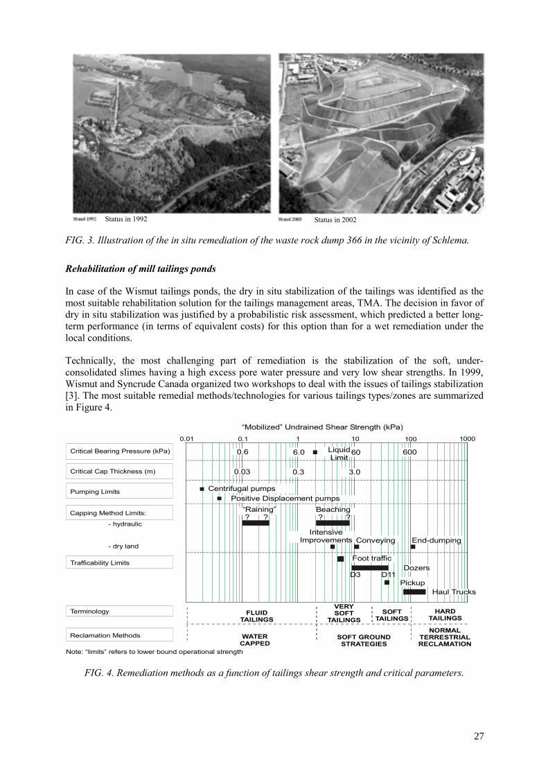
FIG. 3. Illustration of the in situ remediation of the waste rock dump 366 in the vicinity of Schlema.
Rehabilitation of mill tailings ponds
In case of the Wismut tailings ponds, the dry in situ stabilization of the tailings was identified as the most suitable rehabilitation solution for the tailings management areas, TMA. The decision in favor of dry in situ stabilization was justified by a probabilistic risk assessment, which predicted a better long-term performance (in terms of equivalent costs) for this option than for a wet remediation under the local conditions.
Technically, the most challenging part of remediation is the stabilization of the soft, under-consolidated slimes having a high excess pore water pressure and very low shear strengths. In 1999, Wismut and Syncrude Canada organized two workshops to deal with the issues of tailings stabilization [3]. The most suitable remedial methods/technologies for various tailings types/zones are summarized in Figure 4.
0.6 6.0 60060Liquid Limit
D11D3
Foot traffic
Pickup
Dozers
Haul Trucks
0.03 0.3 3.0
Centrifugal pumpsPositive Displacement pumps
“Raining” ? ?
Beaching ? ?
IntensiveImprovements Conveying End-dumping
“Mobilized” Undrained Shear Strength (kPa)
Critical Bearing Pressure (kPa)
Critical Cap Thickness (m)
Pumping Limits
- hydraulic
- dry land
Capping Method Limits:
Trafficability Limits
Terminology
Reclamation Methods
Note: “limits” refers to lower bound operational strength
FLUIDTAILINGS
WATERCAPPED
VERYSOFT
TAILINGSSOFT
TAILINGSHARD
TAILINGS
SOFT GROUNDSTRATEGIES
NORMALTERRESTRIALRECLAMATION
0.01 0.1 1 10 100 1000
FIG. 4. Remediation methods as a function of tailings shear strength and critical parameters.
Status in 1992 Status in 2002
27

Dry in situ stabilization of tailings ponds involves the following steps: (a) removal of the supernatant water from the pond; (b) placement of an interim cover on the tailings surface to avert dust development and provide top load to initiate consolidation; (c) building of a stable surface contour to provide suitable run-off conditions for surface water; and (d) placement of a final cover.
FIG. 5. The Trünzig tailings pond in 1991 and after placement of the interim cover in 2002.
The infiltration limiting function of the final cover over the consolidated tailings or waste rock piles can be realized either by a sealing layer or by a storage layer, which maximizes infiltration water storage in the cover till it is removed by evapotranspiration. The advantage of the evapotranspirative cover, beside lower costs, is the lesser susceptibility to disruptions arising from differential settlement, cracking, root penetration, burrowing animals and human actions.
The final shape of the remediated objects is realized in such a way as to divert the surface water off the surface. While both convex and concave shapes provide suitable solutions, the final shape of the tailings ponds of Wismut is preferably realized as valley type landforms because it requires less earthen material to be imported to the site. Hill type landforms have been realized by Wismut in external projects where abundant earthen material was available on site (Sillamäe, Estonia).
Treatment of contaminated water
The mine waters and seepages coming from the Wismut sites usually cannot be discharged untreated into the receiving streams because they contain radioactive (U and Ra) and chemical (As, Fe, and Mn) contaminants above the regulated limits. Also other components such as Mg and Ca along with sulfates, chlorides and carbonates are limiting factors because they cause extreme hardness of the water.
The seepage from rock dumps is comparatively small (1 to 30 m3/h). The dewatering of tailings ponds requires initially the treatment of some hundreds m3/h (250 m3/h at the Helmsdorf site). The concentration of contaminants in the tailings pond water changes in the course of removal of the supernatant pond water as the dilution by precipitation and the contribution of the pore water from the tailings increase.
Composition of both waste rock seepage and tailings pond seepage (till consolidation is completed) usually remains almost unchanged for a long period of time.
The largest sources of contaminated water discharge are from mine flooding. Discharge rates from flooded mines vary from 50 m3/h (Pöhla mine) up to 1 000 m3/h (Schlema mine). While contaminated mine water will not emerge at ground surface during flooding of the Königstein underground leach mine, the mine water may enter into an aquifer of regional importance and potentially reach the Elbe
Status in 1991 Status in 2002
28

river [4]. To control the flooding of this mine a water treatment plant of a capacity of 450 m3/h is in operation.
When simulating mine flooding, predictions limited to periods not exceeding the duration of the preceding observational period proved to be more reliable. This limitation usually ensures a reasonable spatial scale-up of the prediction as well. Experience tells that high contaminant load in the mine water discharge usually endures 5 to 25 years after which the peak concentration (first flush) decreases approximately exponentially (depending on the specific site conditions and the hydraulic regime imposed) [5].
With the decreasing contaminants load in the discharge, the specific costs of water treatment increase. Below a threshold value of contaminants load the standard chemical water treatment technologies become uneconomical. Because water treatment costs present approximately 15 to 20% of overall remediation costs, it is imperative to adjust water treatment to the evolution of the chemical composition and volume changes of the discharge. The WISMUT’97 workshop investigated possible alternative water treatment technologies [5]. As demonstrated at the workshop, beyond a threshold limit a water treatment technology switch becomes necessary. To this end, the following alternative water treatment technologies are being currently tested: (a) direct underground treatment of mine water (e.g. aeration, precipitation); (b) discharge through constructed wetlands; (c) use of permeable reactive barriers; (d) use of micro-organisms for in situ treatment of contaminants.
4. Environmental monitoring
Environmental monitoring comprises (a) monitoring of the base line and (b) monitoring of the remedial activities. Baseline monitoring includes measurements of emissions, impacts, effluents and the assessment of the environmental effects of rehabilitation. The radon concentrations, dust-borne long-lived alpha emitters as well as contaminant levels in surface and ground water are being monitored at approximately 1300 points. Upon completion of remediation, a post-remedial performance assessment phase of 5 years is foreseen by Wismut, this phase may be followed by a surveillance period of not yet specified duration, which may last as long as 20 years.
5. Results of remediation
After twelve years of remediation/reclamation more than 60% of the SDAG Wismut legacy have been remediated and (by the end of 2003) approximately € 4.1 billion invested into the reclamation. A successful transfer of the Wismut know how and remediation technology has been taking place since 1995, particularly into the countries of Central and Eastern Europe. Since summer 2002, these activities are performed through a daughter company WISUTEC. Table 1. Remediation results achieved by June 2004.
Operation Status June 2004 In %
Completion anticipated
Remediation underground - Mine workings abandoned 97 2008 - Shafts, adits and galleries filled 97 2008 - Remediation of shallow mine workings 87 2005 Remediation on the surface - Demolition of plants/structures 85 2015 - Mine dumps relocation 75 2007 - Mine dumps covered 65 2009 - Backfilling of the Lichtenberg open pit 80 2010 - Tailings intermediate covering 85 2015 - Site reclamation 50 2015
29

The remediation costs related to the uranium produced are approximately € 28.6/kg U, which appears in an international comparison reasonable [6].
Emissions from the Wismut sites significantly improved and considerable areas and objects have been prepared for reuse by the communities or other legal subjects.
The contribution to regional development is evident from the results, such as the successful re-establishment and rise of the health spa at Schlema. Another illustration of Wismut’s role in this respect is its support for the preparation of the Federal Horticultural Show (BUGA) in Ronneburg/Gera to be held in 2007 by matching the corporate remedial design, planning and implementation of remediation of the Ronneburg open pit mine to coincide with the BUGA schedule.
6. Future tasks
The good progress of remediation (Table 1) was achieved by a high level of standardization. Nevertheless, experience has taught us that a schematized transfer of remedial solutions from site to site, from object to object does not necessarily provide the most efficient solution. The adjustment of proven concepts and measures to the site-specific conditions will remain a challenge during the continuation of the rehabilitation project as well.
Nevertheless, even after completion of the physical work some long-term tasks remain; these include: (a) control and treatment of contaminated water; (b) mine damage control and compensation; (c) care and maintenance of rehabilitated objects and of associated installations; and (d) environmental monitoring.
In order to ensure long-term stability and integrity of the objects rehabilitated for a restricted use such as the tailings ponds, waste rock dumps, and the remediated pit Lichtenberg as well as the functionality of the covers, all realistic failure mechanisms are identified, the likelihood of their occurrence quantified and the hypothetical consequences evaluated. In accordance with the legal requirements, provisions have to be made to provide institutional control of the residual risk of failure from the rehabilitated objects and to identify a legal entity responsible for this task, such as an operating unit.
With regard to the needs and scope of monitoring and maintenance, a distinction is made between (a) a post-rehabilitation phase and (b) remaining long-term tasks. Phase a) extends up to 5 years necessary to demonstrate stable implementation of remediation work. During both phases the obligation may exist to treat the contaminated water, provide seismic surveillance and subsidence measurements and regularly monitor emissions in the vicinity of remediation objects (in the air, in groundwater, and in receiving streams). The site inspections will include the checking of drainage channel conditions, of seepage collection systems, of embankment stability, of possible human impact, and for surface damages, erosion gullies, bioturbation, or damages to vegetation.
Transfer of ownership of rehabilitated objects and areas for reuse requires a thorough assessment and proper documentation of health and environmental risks on a site-specific basis. The environmental assessment will have to be put forward in a comprehensible manner in order to meet with acceptance. It should be emphasized, however, that objects or areas remediated for restricted use might not lend themselves to standard marketing procedures. With regard to liability issues associated with the transfer of ownership of the remediated objects for reuse, there is an urgent need for a clear-cut pragmatic regulatory approach to the issue.
30

REFERENCES
[1] WISMUT’ 95, Proceedings of International Workshop on Environmental Remediation in Waste Rock Piles, November 6–8, 1995, Chemnitz, Germany.
[2] JAKUBICK, A.T., KAHNT, R., “Remediation oriented use of conceptual site models at WISMUT GmbH: Rehabilitation of the Trünzig tailings management area” in Merkel, B. J. et al. (Eds.) Uranium in the Aquatic Environment. Proceedings of the International Conference Uranium Mining and Hydrogeology III and the International Mine Water Association Symposium, Freiberg, Germany, 15–21 September 2002. Springer-Verlag 2002.
[3] WISMUT’99, Proceedings of International Workshop on Stabilization of Fine Tailings, Part 1: The Scientific Basis, Edmonton, Canada, May 26–27, 1999, Syncrude Canada Ltd. And Part 2: Practice and Experience, Chemnitz; Germany, June 23–25, 1999, Wismut GmbH.
[4] JAKUBICK, A.T., JENK, U., KAHNT, R., “Modeling of Mine Flooding and Consequences in the Mine Hydrogeological Environment: Flooding of the Koenigstein Mine, Germany”, Environmental Geology, Springer, 2002.
[5] WISMUT’97, Proceedings of International Workshop on Water Treatment and Residues Management — Conventional and Innovative Solutions, September 24–26, 1997, Chemnitz.
[6] HAGEN, M., JAKUBICK, A.T., LUSH, D., METZLER, D., “Integrating Technical and Non-technical Factors in Environmental Remediation”, Proceedings of UMREG’02, 2003, Wismut GmbH.
31


RE-CONTOURING AND FINAL COVERING OF TRÜNZIG AND CULMITZSCH TAILINGS PONDS AT WISMUT
U. BARNEKOW, A. NEUDERT, U. HOEPFNER WISMUT GmbH, Engineering Department, Chemnitz, Germany
Abstract. WISMUT GmbH is currently decommissioning the uranium mill tailings ponds at Trünzig (area: 115 ha; vol.: 19 Mill. m3; tailings thickness: up to 33 m) and at Culmitzsch (area: 235 ha; vol.: 85 Mill. m3; tailings thickness up to 72 m). From 1960 to 1990 the former Soviet-German Wismut company milled uranium ore and processed a total of about 110 000 t of uranium at the Seelingstädt mill (Thuringia / Germany) nearby the tailings ponds. Tailings were disposed of in the Trünzig tailings pond from 1960 to 1967 and in the Culmitzsch tailings pond from 1967 to 1990. Tailings disposal dams had been erected for separate disposal of uranium mill tailings from soda-alkaline leaching and from acid-leaching at both the Trünzig and Culmitzsch ponds. Decommissioning of tailings ponds started in 1991 and consists of the following basic decommissioning steps: expelling of pond water and seepage catchment including water treatment; interim covering of subaerial tailings surfaces; re-contouring of dams and of the pond surfaces and final covering including vegetation. This paper presents the conceptual design for future re-contouring of the Culmitzsch tailings pond and the design and decommissioning progress achieved for re-contouring and final covering of the Trünzig tailings pond. In addition the paper presents experience in designing final pond covers based on field data including water balance modeling of the final cover performance.
1. Introduction
From 1960 to 1990 the former Soviet-German Wismut company milled uranium ore and processed a total of about 110 000 t of uranium at the Seelingstädt mill in Thuringia; Germany. Tailings were disposed of in the nearby Trünzig tailings ponds from 1960 to 1967 and in the Culmitzsch tailings ponds from 1967 to 1990. Tailings were disposed in former uranium open pits at Trünzig-Katzenbach and Culmitzsch. A large tailings dam and several waste rock dams were erected for separate disposal of uranium mill tailings from soda-alkaline leaching and from acid-leaching. This paper presents the over-all decommissioning progress achieved since 1991, the conceptual design for future re-contouring of the Culmitzsch tailings ponds and the design and decommissioning progress achieved for ongoing re-contouring and final covering of the Trünzig tailings ponds. In addition the paper presents experience obtained while designing final covers based on field data including water balance modeling of the final cover performance.
2. Decommissioning progress achieved
WISMUT GmbH is currently decommissioning the uranium mill tailings ponds at Trünzig (area: 115 ha; vol.: 19 Mill. m3; thickness: up to 33 m) and at Culmitzsch (area: 235 ha; vol.: 85 Mill. m3; thickness up to 72 m). Figure 1 shows the tailings ponds at Trünzig (in the foreground) and Culmitzsch (in the background) in 2002. Both tailings ponds consist of two individual ponds containing uranium mill tailings from either acid leaching including neutralization or from soda-alkaline leaching. During tailings disposal sandy tailings beaches settled near the former discharge spots while fine tailings settled more distant under subaqueous cover. Uranium tailings typically contain an average concentration of 9 Bq/g of radium.
Decommissioning must ensure safe storage of the tailings for the long term reducing the additional equivalent dose to the population from all pathways to less than 1 mSv/a. Requirements for waste water discharge into the receiving streams were set by the authorities of Thuringia. Dry in situ stabilization including dewatering by technical means has been selected as the preferred option for decommissioning the Trünzig and the Culmitzsch tailings ponds. This preferred option for decommissioning, which was agreed to by the authorities, includes the following fundamental decommissioning steps: expelling of pond water and seepage catchment including water treatment; interim covering of subaerial tailings surfaces; re-contouring of entire tailings ponds and final covering including vegetation.
33

FIG. 1. Trünzig tailings pond (foreground) and Culmitzsch tailings pond (background) in 2002.
FIG. 2. Trünzig tailings pond in 2003.
After uranium tailings disposal was terminated in 1990, immediate measures were taken to avoid acute environmental risks. Subaerial sandy tailings beaches were protected with interim covers to avoid blowing dust. Seepage catchment systems used during tailings disposal were renovated and improved. Seepage and expelled pond water was collected and treated at the Seelingstädt mill before being discharged. Due to demolition of the mill a new water treatment plant was erected nearby the sites in 2001.
Tailings pond Trünzig A was interim covered by 1995 (Fig. 1). Pond water from tailings pond Trünzig B was expelled by 2002 (Fig. 1) and an interim cover was placed on the entire pond area by 2003. Figure 2 shows the status of the Trünzig tailings ponds in 2003. Re-contouring of the Trünzig tailings pond started in 2002 and is still ongoing. Recently the surrounding dams have been almost completely reshaped. Placement of the final cover started on the tailings beaches of pond A in September 2004. Final covering is foreseen to be completed by 2009.
34

The tailings beaches of the two individual ponds A and B of Culmitzsch were interim covered by 1995. The pond water of pond B was expelled, treated and discharged by the end of 2002. The fine slimes of pond A and B are currently being interim covered. In 2004 subaqueous emplacement of the first layer of the interim cover was completed using a swimming barge. The last pond water will be expelled by 2005. During the next several years the interim cover will be placed progressively on the dried fine tailings surfaces of both pond A and B. Re-contouring of the dams and ponds surfaces is foreseen to be carried out from 2006 through 2015.
3. Conceptual design for re-contouring of the Culmitzsch tailings pond
Re-contouring of the Culmitzsch tailings pond was designed based on evaluation of technical, economical and environmental benefits following the German regulation (VOAS) with respect to: guaranteeing geotechnical stability of the entire re-contoured tailings pond; minimizing the volumes of soils and radioactively contaminated materials to be removed; and creating a landscape and vegetation adapted to the surrounding landscape. The conceptual designing of the pond area included the following basic work steps:
• Development of a 3D-model of the tailings pond’s structure and spatial distribution of tailings properties (as a basis for all further modeling and design calculations),
• 3D-modelling of the settled tailings surface including prediction of time-settlement and evaluation of measures to speed up tailings consolidation,
• Fixing outlet points, positions and gradients of trenches for diverting runoff, • Hydrologic modeling of the runoff of the entire catchment area, • Designing of dam reshaping with respect to geotechnical stability to the long term, • Dimensioning of re-contouring of waste dumps with respect to geotechnical stability and for
environmental reasons, • 3D-modelling of the optimum surface contour requiring the minimum fill volume to build the
re-contoured surface.
Figure 3 shows the conceptual design of the re-contoured Culmitzsch tailings pond before final covering. The outer dams are designed to be reshaped by cutting the dam crests combined with dam butressing. The conceptually designed dam buttresses contains a total volume of 1.85 Mm3. The conceptual design for re-contouring of the pond areas was optimized based on modeling of the time-settlement of the tailings and the time dependent loading of the tailings surfaces during re-contouring works. Settlement calculations resulted in an estimated total settlement volume of 4.9 Mm3. Total settlement of up to 4 m to 7 m was predicted in the area of thick fine slimes. To handle this problem fine tailings consolidation will be accelerated using deep vertical wick drains in certain areas.
To ensure long-term geotechnical stability and environmental compliance, certain of the surrounding waste dumps will to be removed. Figure 3 shows the waste dump slopes to be relocated and reshaped. All the additional fill volume needed will be relocated from the Lokhalde waste dump east of the tailings ponds. A total of 14.9 Mm3 of fill volume will be needed including 0.5 Mm3 to be relocated inside the pond areas.
Hydrologic modeling was carried out for designing the catchment areas. The models compared the runoff of a 100-year flood event for a pre-mining scenario with post re-contouring and final covering scenarios using different vegetation covers. Based on the results a decision was made to plan for a retention pond at the existing lake “Schwarzer Teich” west of the Culmitzsch tailings pond (Fig. 3). In addition all trenches for diverting surface runoff were dimensioned with respect to the 100 year flood event. The designed re-contouring reconstructs the ancient catchment areas which existed before mining. The surface runoff is diverted via trenches from the southern pond A via the separating dam to pond B. The runoff from both ponds is diverted via the western border of pond B. An additional trench diverts the runoff from a minor area of the eastern pond B.
35

FIG. 3. Conceputal design of the re-contoured Culmitzsch tailings pond.
4. Re-contouring of Trünzig tailings pond
WISMUT is currently re-contouring the Trünzig tailings pond to a shallow valley shape. In each invidual pond the runoff will be diverted from shallow contour hills being constructed on the tailings beaches next to the dam crests to a main trench located in the fine slimes. The main trench in pond A will divert the runoff via a cut in the western dam while the main trench in pond B will divert the runoff via a cut at the dam located at the East side of pond B. Figure 2 shows an airphoto of the current status of the re-contouring activity. Since 2002 the northern tailings dam has been completely reshaped by dam buttressing in front of the dam toe (slope inclination v:h = 1:4) combined with reshaping of the upper dam slope inside the pond area to a slope inclination v:h = 1:5. Excavated tailings were relocated on the tailings beaches next to the dam crest building up shallow hills. Relocated tailings were immediately interim covered by 0.5 m of waste dump material. Reshaping of the other surrounding dams is almost completed.
In the fine tailings area of pond A, WISMUT is currently accelerating consolidation of the fine slimes along the future main trench for diverting the surface runoff from the re-contoured surface of pond A. An 1100 m long and up to maximum 11 m high embankment is currently being constructed. Deep vertical wick drains were installed before embankment placement in a triangular grid of 3 m spacing to 90% depth of the tailings thickness (up to 30 m) to allow consolidation of fines along the future main trench by the end of 2006. The time settlement and deformation of the tailings underneath the embankment fill is monitored by WISMUT in an extensive monitoring programme. Based on the continuously monitored data the decline of settlement rates with time is being observed. At the end of the primary settlement the upper part of the embankment will be removed.
36

5. Performance assessment of the different cover designs
Assessment of the cover design options at Trünzig, on a tailings surface with spatially changing tailings characteristics (such as the changing pyrite content) required the use of a number of highly specialized models and the implementation of the results of these detailed models in the context of the physical realities of the site while maintaining an overall site remediation focus.
Due to the fact that the simulations required for the site involved very different time scales for surface water flow and ground water flow as well as for contaminant release and contaminant transport, the use of a multi-compartment model was selected for conceptual description of the site. In the compartmentalized model description, the site was subdivided into representative, well defined units (such as the remedial objects, receiving stream and ground water), which were connected to detailed process models handling the particular, highly specialized hydrogeological, geotechnical and geochemical questions.
For instance, a detailed hydrologic model was used to assess the runoff from the surface of the re-contoured Trünzig and Culmitzsch tailings ponds simulating different types of final cover designs and using different vegetation scenarios. The water balance for each final cover design type has been simulated to determine the effectiveness of the design. The HELP and HYDRUS codes were used to simulate the water balance for the cover designs described in the following chapter. Geotechnical calculations were needed to evaluate the stability of the cover against sliding on steep dam slopes, erosion, suffusion, and effects of differential settlement.
The model system was developed in stages, following the problem solution needs of the remedial implementation project. To maintain model consistency in the course of development, a common platform had to be created first on which the very heterogeneous data and information provided by the detailed models could be structured, mass balanced and integrated within the compartmentalized description of the site. The software platform used for integration of the overall model system was termed the Conceptual Site Model1 (CSM) platform. Thanks to the compartmentalized description of the site and selective, problem oriented inclusion of the detailed models into simulations (i. e. the detailed models not required for the solution of a particular problem were automatically excluded from the simulation run), the CSM platform allowed fast performance assessments and sensitivity runs, thus making the model system a very convenient planning and decision making tool.
The compartments used in the CSM approach are smart compartments, not common black boxes2. Each of the compartments, if required, can be readily resolved in greater detail, both spatially and by increasing the details of the process description or by inclusion of new specific processes.
These characteristics allow for one to easily structure and interrelate heterogeneous results of available studies, laboratory and field tests, water quality and water level/flow measurements, existing morphological/geological models and to start to investigate the importance of key model assumptions at an early stage. In this particular case, the task of the CSM platform (as opposed to the detailed models) was to calculate the integral response of the cover designs to variation and changes of the key parameters in the specialized models in terms of contaminant loads and mass balances entering the tailings underlying the cover.
Implementation of the CSM was realized under the Goldsim code (Golder Assoc., Seattle). This code was selected because of its capability to handle parameter and geological structural uncertainties stochastically in a user friendly way. Input for the cover design ranking were either figures or distributions of:
1 The term conceptual model is used in an extended sense (i. e. beyond the development of conceptual understanding) including model selection, model set up and conversion into a simulation model.
2 The compartments used are not simple black box - every box compartment may have a complex internal structure
37

• Probabilities describing failure modes of the design under a set number of conditions, • Consequences associated with the failure, such as doses, cost etc., • User defined “other” decision criteria, • Tradeoffs between the decision criteria.
Output of the CSM ranking tool was the quantification of the overall score of every design and the resulting ranking and prioritization.
In summary, in this particular case the approach allowed for traceable decision making of the selection of the cover design and a defendable reasoning for the selection required for the permitting process.
6. Field testing of different final cover designs
For evaluation of the best-suitable design for the final cover, a large test field was constructed in 2000 on the site of the former Seelingstädt mill. Figure 4 presents a map of the test field. This test field encloses ten individual fields for testing the hydraulic effectivity of different final cover designs: Eight fields sized 10 m × 20 m with a surface inclination of 2% (4 fields) or 8% (4 fields) and two fields sized 10 m × 10 m with a surface inclination of 20%. The following different cover concepts have been tested:
• Storage layer design type constructed of one layer consisting of clean waste dump material (mixed-grained soils).
• Cover design type consisting of a profile of two layers (storage layer/sealing layer) or three layers (storage layer-drainage layer-sealing layer). The sealing layer was constructed of two different materials either of quaternary loam or of weathered Permian red-bed sediments. The storage layer consists of waste dump material (mixed-grained soil).
• Capillary barrier design type enclosing a storage layer of waste dump material (mixed-grained soils).
Lysimeters were installed on each of the 10 test fields for continuously measuring surface runoff, interflow in the storage layer and, if existing, also in the drainage layer or in the capillary barrier, respectively. Infiltration through the sealing layer and infiltration through the underlying interim cover is measured as well. Volumetric water content is measured by TDR-probes (time-domain reflectometry) installed within the layers. In addition soil suction is measured by tensiometers and equitensiometers. Temperature is also measured at specific depths to determine frost depth. Percolation through the interim cover is collected by a drainage layer underlain by a foil liner forming a trough. Lateral interflow and runoff are collected downstream in a drainage system and measured continuously by tipping bucket counters. In addition small sized (500 cm2) plate lysimeters are installed in four of the ten test fields. A weather station continuously measures the following meteorological data: air temperature, air humidity, wind direction, wind speed, global radiation, precipitation at 1 m above surface and at surface level.
The water balance of the final cover is one of the relevant seepage controlling parameters. Radon emanation and oxygen intrusion by gas diffusion through the final cover must be controled by permanent saturation of at least one final cover layer. Infiltration through the final cover must be controlled with respect to the volume and chemical composition of the seepage from the tailings pond.
38

FIG. 4. Map of the final cover test field site.
After over three years of testing preliminary measurement results show large differences in the observed percolation (infiltration) rates. To date the measured data of the one layer system consisting of only a 2.7 m thick storage layer vegetated by grass showed very little annual percolation rates. The final cover design types containing a sealing layer also show very little annual percolation rates. A two-layer system consisting of an upper 1 m thick storage layer and a lower 0.4 m thick sealing layer was tested in field no. 2. During dry seasons quite high soil suctions were measured in the sealing layer, which could be harmful to the sealing layer with respect to cracking. From this it followed that to reduce this risk the thickness of the storage layer should be increased sufficiently. This was done for designing the final cover on the Trünzig tailings pond presented below.
7. Final covering of Trünzig tailings pond
Preparation for final covering of the northern part of pond A started in the summer of 2004. Final cover placement began in September 2004. Figure 5 presents the layering of the final cover and of the underlying interim cover no. 2. The interim cover no. 2 was placed on tailings relocated from the dam to the tailings beaches on the interim cover no. 1. It consists of 1.0 m of waste dump material (mixed grained soils) relocated from near the site. Before final cover placement interim cover no. 2 was compacted reducing the permeability coefficient to kf ≤ 5 • 10-9 m/s. The final cover is a cover design type containing a storage layer and a sealing layer. Both layers are built using material from the Lokhalde waste dump located near the site. This waste dump material is a mixed-grained soil. Its permeability is controled by its density or degree of compaction. The lowermost 0.5 m thick layer will be compacted to achieve a compaction degree of DPR ≥ 95% which results in a permeability coefficient kf ≤ 5 • 10-9 m/s. Above this layer an 1.5 m thick storage layer will be placed without any compaction
39

measures. Compaction degree of the storage layer will be DPr = 88% - 92% in the pond area and DPr = 92% - 95% on the dam slope of the northern tailings dam.
The vegetation on the final cover of the Trünzig tailings will vary in different areas. Vegetation will range from grass areas allowing succession to bushes or forests and grass areas with single or groups of trees.
FIG. 5. Layering of the final cover on the northern tailings beaches of Pond A.
40

PROBLEMS AND SOLUTIONS FOR WATER TREATMENT AT THE CLOSED HUNGARIAN URANIUM INDUSTRY
G. ERDI-KRAUSZ GEO-Faber Co., Hungary
Abstract. The Hungarian uranium company produced 22 000 tonnes uranium (tU) before ceasing production activities at the end of 1997, after 42 years of operation. The government has accepted a “Conceptual Plan” for total remediation of the former uranium production area, and the plan is currently being implemented. One of the main rehabilitation problems was treatment of water from two different sources: inflow of mine water contaminated with uranium and seepage water from the tailing ponds, which are contaminated with different salts. In the latter case the problem is immediate because there is a significant aquifer in the neighbourhood of the tailing ponds, which provides part of the drinking water supply for a town with about 200 000 inhabitants. The mine inflow did not cause great difficulties because during mining operations water was pumped from certain isolated parts of the mine and was treated, resulting in recovery of 5-12 tU/year. After the shut-down of the mines, pumping was stopped, so water will begin to rise in the 1000 m deep shafts and the galleries on the different mine levels. By some calculations, the mine inflow will reach the surface after 36 years. The solution for the near-term water treatment problems related to the tailings ponds was construction of a small water treatment plant, which is already in operation. When the rising mine water reaches the surface (in 36 years), it will come out only one, well-controlled place. If necessary an additional water treatment plant will be constructed to treat the mine water. Several possible solutions have been offered for isolation of the groundwater polluted by tailings pond seepage:
• Cutwall around the tailings ponds. Very expensive, very sophisticated, but not very safe. • Pumping fresh water into the soil to wash-out the salts. It is very difficult to control the spread of the diluted water. • Pumping out and treating the polluted groundwater until the surrounding groundwater is free from
the salt pollution (groundwater sweep).
1. The site
Hungary’s only industrial uranium producing area is in the Mecsek mountains in the southern Transdanubian region, about 10–18 km west from Pécs, the third largest town of the country. The uranium deposits are in Permian sandstone. Following successful exploration programmes, the company established 5 mining plants and a hydrometallurgical processing plant. Because of structural dip, the uranium lenses in the southern part of the mining district were close to the surface, while those in the northern part are found at a depth of more than 1100 m.
After closing mining plants No. 1 and 2, all ore produced from the mines arrived at the surface through only one shaft. Following a radiometric classification, the industrial ore was transported by trucks to the mill, while the low-grade ore went to the heap leaching area.
Prior to the shut down of the uranium industry, the company produced 22 000 tU, which was exported to Soviet Union and later to Russia. The yearly production served the fuel requirements of the 1760 MWe capacity Hungarian Nuclear Power Plant in Paks.
2. The water
The area affected by uranium mining and processing has limited sources for domestic water. The 1500–1600 m thick Permo-Triassic sandstone and conglomerate, which contains the uranium deposit, is in vertical communication with shallow aquifers through mine workings
41

and geologic faults. The shallow aquifers supply more than 50% of the water-supply to the town of Pécs, which has a population of 200 000.
3. The problems
3.1. The mining water
The mining activity caused major changes in the deeper hydrogeological system. During mining operations it was necessary to de-water the deeper mines, which affected the water table. Water from de-watering the mines was treated to remove uranium and this process will be continued. At one time, 5–12 tU/year was recovered from this water; recently, however, only 2–3 tU/year is recovered. During the mining operation the treated water was utilized in the processing plant, as industrial water.
As the mining activity progressed to greater depths de-watering volumes reached between 1500 and 2200 m3/day. This pumping activity created a cone of depression above the excavated chambers and galleries, which affected an area of about 42 km2 and reached depths of 100–400 m from the surface. The cone of depression associated with mining plant No. 1 still exists.
Dewatering activities ceased in the northern part of the district with the closing of the mines at the end of 1997. As a consequence excavated areas within the mines will be slowly filled by in flow of mine water. The water level is rising in the mines, and by some calculations it will reach the surface after 36 years, or in 2033. There is also some concern that the mine water will become more contaminated because of contact with higher soluble material and uranium content. Therefore it will need to be treated, but this premise needs to be further evaluated. Currently, the water originating from the mines or mining activity in the northern part of the uranium area is polluted with low salt content (2–3 g/dm3), but relatively higher uranium content (> 2 mg/dm3).
The water, which is flowing from the base of the waste heaps, comes from rainwater infiltration. The waste heaps are saturated with this water, therefore, water draining from the waste heaps must be collected and treated so that it does not pollute underlying groundwater.
3.2. The groundwater
Groundwater problems quantified
A balance of materials by Dr. M. Csovari, illustrates the general problems.
Approximately 46.8 M tonnes of ore was excavated during 42 years of uranium mining. Following the initial stage of mining, when ore rather than yellowcake was exported, there remained in the Mecsek area 45.4 M tonnes of ore, or its processed remains, containing 2 808 tU. About half of this quantity was in the tailing ponds, in a fixed form. The quantity of the waste materials in the tailing ponds is 20.4 M tonnes, together with the following auxiliary processing materials:
• 1939 k tonnes sulphuric acid, • 623 k tonnes manganese ore, • 472 k tonnes caustic lime, • 219 k tonnes limestone, • 100 k tonnes hydrochloric acid in 30% concentration, • 84 k tonnes industrial salt, etc.
42

The greatest water treatment problem in the Mecsek operating area is related to cleaning up groundwater, which has been polluted by seepage from the tailings ponds. Seepage solutions together with precipitation of pollutants from these waters have a volume of about 19.7 Mm3. Taking into consideration the spreading of the polluted groundwater and the proximity of the water table, the first task was to stop the spreading of pollutants and to begin cleaning up the polluted groundwater. The components of the polluted groundwater are mainly dissolved salts and very low levels of radioactive material.
Groundwater contaminated by tailing ponds seepage has been shown to have migrated about 1-1.5 km laterally away from the tailing ponds. Polluted groundwater is also endangering the shallow water table. The level of the contaminant content was variable. The highest total salt content was measured between the two tailing ponds, with magnesium sulphate, chloride, and manganese accounting for the highest pollution levels.
The above mentioned mining and groundwater problems have been analyzed and plans have been formulated to resolve the problems in the most efficient ways possible.
4. The solutions
4.1. The mining water
The problem of mine water inflow from Mining Plant No 1., has potential for near-term impact on the water table. The seepage water from a waste heap close to the excavated chambers of Mining Plant No. 1 has increased the uranium content in the mine inflow. Pumping of the mine inflow is continuing to reduce the potential impact. The uranium content will decrease over time thus reducing the risk to the water table. Nevertheless, pumping out and treating the water to remove the uranium will be continued until 2007.
During the years of operation, uranium recovery from mine water treatment was done in the hydrometallurgical plant. After the plant was shut down, a small water treatment plant was built. Yearly production from this plant is about 3 tU in the form of peroxide, which has a uranium content of 70%.
The deeper mines — Mining Plants No 2, 3, 4, and 5 — present another problem. After mining ceased and dismantling of engines, machines and everything which was valuable or polluted by oil was complete, the company ceased pumping water out of the mines. As a consequence, water levels are rising in the mines. Because of the depth of the shafts and the deepest mining levels, 1000-1100 m, the relatively low water content in the sandstone, and the volume of material excavated from the mines, about 18 Mm3 rock, the rise in the water level will be very slow. It has been calculated that the mine water level will reach the surface in 36 years.
There is only one place — the main transportation tunnel in the former mining plant No 3.— where the water will flow out of the mine workings so it will not be difficult to control it in quantity and quality.
There is a possibility that the water will have higher uranium content, as a result of flowing through the excavated chambers and galleries. In this case, there will be a need to build additional water treatment capacity. After recovery of the uranium, the treated water will be released into the environment.
43

Whether after 36 years, the mine water will exceed regulatory limits is questionable. This opinion is based on the following considerations:
• The volume of this water is very large compared to the soluble uranium. • Dissolving uranium from the sandstone by water alone is unlikely. • The rate of water flow is very low and there is no agitation that would facilitate
“washing” uranium or other pollutants from the walls of the mine workings.
Materials from the former alkaline heap leaching operations were transported to the largest waste pile at the former Mining Plant No 3. A ditch-system collects seepage water from this waste pile into a pit and it will be combined with the mine inflow from Mine Plant No. 1. for treatment and recovery of the uranium.
4.2. The groundwater
It was recognized when uranium production creased that the tailings ponds would have to be covered to protect the underlying groundwater. Rainwater continues to infiltrate the tailings, increasing pore water pressure and helping to spread pollutants into the groundwater. Therefore to prevent this process from continuing several remedial measures are being implemented:
• Installation of drainage ditchs, • Evaporation of surface water, • Stabilization of the fine tailings or slimes, • Covering of the tailings, including drainage layers, • Protection against infiltration of surface water, • Soil for re-vegetation.
Solutions for these problems are outlined in a companion paper in this document titled “Remediation of tailings ponds I and II”, Authors: G. Folding and G. Nemeth.
44

REMEDIATION OF TAILINGS PONDS I AND II
G. FOLDING, G. NEMETH Mecsek-öko, Pécs, Hungary
Abstract. This paper presents a brief review of the remediation of tailings ponds I and II near Pécs, Hungary, including the steps followed in implementing the project, and descriptions of the applied science and methods used. Two tailings ponds were built near Pécs to contain and store uranium mill tailings. The total area of the two ponds is about 1 600 000 m2 and the estimated weight of the tailing is 20 000 kt. The ponds contain 1 382 t U (TP I: 71.3 g/t U, TP II: 55.8 g/t U). After uranium mining ceased in 1997, remediation of the tailings ponds was the most important part of remediation of the mine-mill complex. Today remediation of TP II is complete. Remediation of the 593 406 m2 area, included relocation of 673 996 m3 of tailings followed by constructing a five-layer cover that includes 214 825 m3 of clay, 169 580 m3 of sand and 549 240 m3 of loess. Of the 1 000 000 m2 total area of TP I, 163 207 m2 is covered. Before covering TP I, 590 623 m3 of tailings were relocated. After recontouring the surface, a cover of 48 981 m3 of clay and 204 088 m3 of loess is being constructed. Remediation of TP I is to be finished in 2006.
Uranium mining in the Mecsek mountains, near Pécs in south-western Hungary started in the 1950s and ceased in 1997. During the mining activity two tailings ponds were built to contain the uranium mill tailings. Figure 1 shows the two tailings ponds at the beginning of the rehabilitation process in 1998. The combined areas of the two tailings ponds total about 1 600 000 m2; the estimated weight of the tailings is about 20 000 kt. Tailings pond I (TP I) was utilized between 1962 and 1980 and between 1990 and 1997; tailings pond II (TP II) was used between 1981 and 1989.
After uranium mining was completed, remediation of the underground mines, waste rock piles and heap leaching sites was begun immediately, mainly because of the need to protect the underground water. Remediation of the tailings ponds was of equal importance from the standpoint of total site remediation. The steps that needed to be implemented to complete remediation of the two tailings ponds were:
• rebuilding of the old drainage system, • groundwater resaturation, • fine tailings stabilisation, • recontouring and preparation of the surface for covering, • covering, • biological remediation, re-vegetation.
Surrounding the tailings ponds there was an old main pipe system with radial pipes in the bottom of the tailings dams which collect dirty water from the core of the dams and from the tailings. The distance between the radial pipes is 25 m. The first step of the remediation was to repair or rebuild this old, unreliable pipe system (Fig. 2). At the same time on the north side of TP I a new water treatment plant was built to treat water from the pipe system, dirty water from the uncovered surface of the tailings ponds and pumped underground water from wells around the ponds. Treated water is released into the Pécsi víz River.
45

FIG. 1. The tailings ponds in 1998.
FIG. 2. Re-building of dam seepage water drainage system.
Parameters in this system that are tested before release of treated water include:
• TDS, (total dissolved solid), total hardness, pH, alkalinity, specific electric conductivity, • Na, K, Ca, Mg, Cl, SO4, CO3, HCO3, Mn, U, Ra226.
To protect the underground water a monitoring and protection system was planned around the tailings ponds. The first part of this system was built in 2000 and 2001; the second phase is being built in 2004. The system consists of groundwater wells, drainage trenches, delivery pipes and of miscellaneouse basins, pumps and other equipment. The first phase included 17 wells, 2 718 m of
1 9 9 8
T P 2
T P 1
1 9 8 1 -8 9
1 9 6 2 -8 0
1 9 9 0 -9 7
T h e ta il in g s p o n d s in 1 9 9 8
T P I.- 1 0 0 h a- 1 5 7 6 8 k t- 7 1 ,3 g /t U- 1 1 2 5 t UT P II.- 5 9 ,3 h a- 4 5 9 9 k t- 5 5 ,8 g /t U- 2 5 7 t U
R e-bu ild ing o f dam seepage w ater d ra inage system
Tested param eters:-T D S, total hardness, pH , alkalin ity, specific electric conduktiv ity
- Na , K , C a, M g, C l, S O 4, C O 3, H C O 3, M n, U , R a226
46

drainage trenches, 4 basins and the necessary delivery pipes. In the second phase 12 wells, 450 m of drainage trench, a basin and a 6-km long delivery pipe system were built. The capacity of the whole system is 2000–2300 m3/d.
The shape of the recontured ponds is a very important factor in the rehabilitation plan. A well planned shape — together with the covering layers — guarantees minimal infiltration into the core of the ponds. On the surfaces of both TP I and TP II two valleys were planned to capture water from the surface. In TP II these valleys are oriented west and east, but on the TP I the two valleys have only one common end point on the southern part of the pond. Concrete barriers were built on the end points of the valleys.
The soft slurry or slimes (fine tailings) in the centre of the pond required stabilization. On the surface of the central part of TP I geotextile and geogrid were laid down over an area of 126 000 m2. A total of 43 000 3–5 m deep vertical wick drains and horizontal drains were installed.
To help dewatering of the core of the tailings pond, two drainage trenches 4-6 m deep, and 160 mm in diameter were built under the planned valleys in TP I. The total length of the drainage is 1 050 m and this system recovers 40 m3 of dirty water per day. The drainage was built by a special machine, which can dig the trench, built in the drainage pipe and the filter pebble in the same step. To help the dewatering process, the first step of recontouring was the filling and pressuring (loading) of the central area of the ponds (the area covered by geomaterial).
During recontouring and dewatering of the tailings ponds (between 2001 and 2004) consolidation on the surface reached up to 1.8 m, but the consolidation was not uniform. Therefore, in this phase geodesic control of the work (and of the sinking) was a very important task.
The next step in the implementation sequence was the covering. The covering layers have three functions:
• infiltration barrier, • radon barrier, • erosion protection.
The covering layers for TP I and TP II are different. Figures 3, 4, and 5 show the characteristics and placement of this 1.5 m thick layer.
During placement of the cover a continous quality assurance programme ensured that the strict expectations for the covering will be met. Figure 5 shows the cone resistance (MPa) versus the depth (m).
The top layer of the cover is soil for the revegetation. The cover has to be effective for a very long time, in this case for a minimum of 200 years. The last step of the rehabilitation effort is biological remediation. Grass, bushes and trees are planted on the top covering layer. On the borders of the ponds low species with dense foliage were planned to encircle the area of the ponds. The species (21 species of trees or bushes) were chosen for this special, not euthropic soil (loess). Because of this poor soil, extra chemical fertilizer was required. In total 200 kg of mixed grass seeds and 8 000 trees or bushes were planted in every ha. The distance between the rows was 2.5 m, and the distance in the rows was 0.5 m. Figures 6 and 7 show various aspects of biological remediation.
During the remediation activity one of the biggest problems has been controling water erosion. The slopes of the recontured ponds were planned without any benches or trenches on the surface, so in places there are 70–80 m long rather steep slopes. After the covering is in place, but before revegation or in the first period of the revegetation (when the grass is not well established) rain causes serious erosion problems on the slopes. To avoid erosion problems on the pond slopes the optimal solution (in effectiveness and price) is a simple ploughing, which prevents the water from running down the slopes until the vegetation is well established and able to stop water erosion. The southern dam of TP II was protected from erosion with 5 800 m2 of grass felt. Use of grass felt is a perfect erosion control
47

solution; the only problem is the cost. Because of the high cost this method is appropriate for use in limited areas where erosion control is critical.
FIG. 3. Function of the covering layer.
FIG. 4. Structure and compostion of the covering.
Figures 8 and 9 show the tailings ponds at the beginning of 2004. Of the 1 000 000 m2 area of TP I 163 207 m2 have been covered. Before installing the cover, 590 623 m3 of tailings were relocated for
Erosion protection
m in. 200 years
4000 m Bq/m 2s
Radon barrier
600-800 m m /a
30-60 m m /a
Infiltration barrier
Function of cover layers:
Covering
Expected in filtration rate: 30-40 m m /a
C overing
D egree of com paction: > 90 %k= < 1 x10 -9 m /sS ealing layer: 0 ,3 m clay
D egree of com paction: > 92 %k= 8 x10⁻⁹ - 2 x10 -8 m /sP rotection layer: 0 ,3 m (onslopes) or 0,4 m loess
D egree of com paction: 85-88 %k= 2 x10⁻⁸ - 4 x10 -8 m /sS torage layer: 0 ,45 m loessTo tal: 1,5
m (o nslopes ) or 1,6 m
D egree of com paction: 80-85 %k= 7 x10⁻⁸ - 9 x10 -8 m /sS torage layer: 0 ,45 m loess
C overing layers (TP I.)
C overing layers (TP II.)
Vegetation
T ailings
T ailings
Vegetation
D egree of com paction: > 90 %k= < 1 x10 -9 m /sS ealing layer: 0 ,3 m clay
D egree of com paction: > 95 %k= < 1 x10 -6 m /sP rotection layer: 0 ,3 m loess
D egree of com paction: 85 %k= 5 x10⁻⁵ m /sD raina ge layer: 0,3 m sand
D egree of com paction: 85 %S torage layer: 0 ,3 m loess
Total: 1,5 m
S torage layer: 0 ,3 m loess
48

contouring. As shown in Figure 4 the TP I cover contains 48 981 m3 of clay and 204 088 m3 of loess. Remediation activity at TP I is expected to be finished in 2006.
FIG. 5. Placement of the covering.
FIG. 6. Biological remediation, revegetation.
Quality assurance
B io log ical rem edia tion , revegetation
G rass:- 20 0 kg m ixed grass seeds / haB ushes or trees:- 21 spec ies- 8 000 p ieces / ha (1-2 years old)- d is tance betw ee n the row s: 2 ,5 m- dis tance in the row s: 0 ,5 mC hem ica l fertilizer:- N 120 kg / ha- P 2O 5 100 kg / ha- K 2O 1 70 kg / ha
The surface of the TP II. in 2004
49

The covering of TP II is complete. During remediation on this 593 406 m2 area, 673 996 m3 of tailings were relocated. The cover contains in 214 825 m3 of clay, 169 580 m3 of sand and 549 240 m3 of loess (Fig. 4). The clay and the sand were obtained from external mines (within 15–30 km distance); the loess was mined from the neighbouring area south of TP II. This solution provides for a very short haulage distance and eliminates use of communal roads so it is very economical. The other advantage is remediation of the mine and the tailings ponds can be conducted simultaneously so this is a very ecofriendly solution. To complete remediation of TP II only biological remediation of the Western part of the pond remains unfinished.
FIG. 7. Biological remediation, revegetation.
FIG. 8. Tailings pond No. I in 2004.
Planting
Area: 100 ha
Covered: 163 270 m2
Relocated: 590 623 m3
Clay: 48 981 m3
Loess: 204 088 m3
Remediation is to be finished in 2006.
50
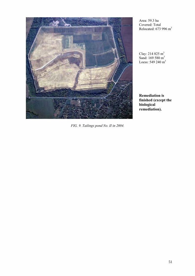
FIG. 9. Tailings pond No. II in 2004.
Area: 59.3 ha Covered: Total Relocated: 673 996 m3 Clay: 214 825 m3 Sand: 169 580 m3 Loess: 549 240 m3 Remediation is finished (except the biological remediation).
51


LEGAL ASPECTS OF URANIUM MINING AND MILLING IN THE CZECH REPUBLIC
J. HORYNA State Office for Nuclear Safey, Prague, Czech Republic
Abstract. The State Office of Nuclear Safety (SÚJB) is responsible for peaceful utilization of nuclear energy and is responsible for supervising government oversight and administration of uranium production and site rehabilitation activities within the Czech Republic. The Atomic Law of the Czech Republic defines SÚJB’s duties and responsibilities as they relate to various aspects of the nuclear fuel cycle. In addition specific laws relating to environmental protection also govern site rehabilitation activities within the Czech Republic. This paper lists relevant laws under which the Czech uranium mining company Diamo must operate and provides criteria that must be considered when:
• Applying for licenses to operate or decommission a facility, • Discharging radioactive material from a site, • Undertaking safety analyses and designing monitoring programmes, • Preparing an environmental impact assessment.
1. Introduction
Mining activities and, subsequently, materials and activities related to the programme to reduce and begin remediation related to uranium mining are administered by the national enterprise DIAMO and are subject to various legislative acts. State administration and supervision of the utilization of nuclear energy and ionizing radiation and in the field of radiation protection is performed by the State Office for Nuclear Safety (SÚJB).
The SÚJB is an independent governmental body responsible for governmental administration and supervision in the fields of peaceful uses of nuclear energy and ionizing radiation. The competence of SÚJB is defined by the Atomic Law (Law No. 18/1997 as amended by the Law No. 13/2002), on peaceful utilization of nuclear energy and ionizing radiation.
The Atomic Act establishes a system protecting the population and the environment against adverse effects of ionizing radiation. The Atomic Law authorized SÚJB to issue implementing decrees.
The basic decree implementing the Atomic Act in the radiation protection area is Decree No. 307/2002, on radiation protection. The Decree specifies details of the manner and extent of the protection of individuals and the environment against adverse effects of ionizing radiation during radiation practices and also during preparation for and actual performance of actions to reduce the existing exposure. Therefore, the Decree is used for implementation of the majority of licenses and authorizations established in the Atomic Act in respect to radiation protection.
Additional important implementing decrees include:
• Decree No. 185/2003, on decommissioning of nuclear installations or workplaces of the 3rd or 4th categories,
• Decree No. 317/2002, on type-approval of packagings for transport, storage and disposal of nuclear materials and radioactive substances, on type-approval of ionizing radiation sources and transport of nuclear materials and specified radioactive substances,
• Decree No. 318/200, on Details of Emergency Preparedness of Nuclear Facilities and Workplaces with Ionising Radiation Sources and on Requirements on the Content of On-Site Emergency Plan and Emergency Rule, etc.
53

Activities and, subsequently, materials and activities related to the reduction programme in uranium mining administered by the national enterprise DIAMO are also subject to further legislative acts including:
• Law No. 44/1988, on Protection and Use of Mineral Wealth (Mining Act), • Law No. 61/1988 Coll., on Mining Activities, Explosives and State Mining Administration, • Law No. 50/1976 on Regional Planning and Building Order, • Law No. 100/2001, on Environmental Impact Assessment, • Law No. 86/2002Sb., on Air Protection against Contaminating Materials, • Law No. 254/2001, on Water (The Water Act), • Governmental Order No. 61/2003, on Indicators and Values of Permissible Contamination of
Surface and Waste Waters. According to the Atomic Law, the following terms are defined:
Nuclear safety is capability of a nuclear installation and its personnel to prevent the uncontrolled development of a fission chain reaction or an inadmissible release of radioactive substances or ionising radiation into the environment, and to reduce the consequences of accidents
Radiation protection is a system of technical and organisational measures to reduce exposure of individuals and to protect the environment
Radioactive wastes are substances, objects or equipment containing or contaminated by radionuclides for which no further use is foreseen.
Radioactive waste management includes all activities in the collection, segregation, treatment, storage, transport and disposal of waste
Radioactive waste disposal means a permanent emplacement of radioactive waste in an areas, facilities or installations without the intention of its further retrieval. The disposal also involves the authorised release of radioactive waste directly into the environment and its dispersion.
Spent nuclear fuel is considered as radioactive waste only if declared.
Decommissioning includes all activities aimed at releasing nuclear installations or workplaces where radiation practices were performed, for their utilisation for other purposes.
Radioactive discharges are planned and controlled releases of liquid or gaseous substance into the environment and containing radionuclides in the amount not exceeding clearance levels or which is released into the environment under the conditions established in the licence for radionuclide discharge into the environment.
Clearence levels are established by the Decree of SÚJB. They are expressed in terms of activity concentration below which a radiation source may be released from regulatory control.
Dose constraint is an upper limit of individual dose delivered by a defined source which serves at the planning stage in radiation protection whenever optimisation is involved.
Uranium mining and milling tailings are not considered as radioactive waste but as a secondary raw materials as stipulated in the Atomic and in the Mining Laws.
Siting, construction and operation of dumps and tailing ponds and management of materials containing or contaminated with radionuclides shall be considered a mining activity according to the Law No. 61/1988. Also any directly related activity is considered a mining activity and any resulting materials are defined as materials from mining activities. These activities are considered as management of materials from mining activities and not radioactive waste management. Therefore
54

uranium mining and mill tailings are not considered as radioactive waste but as secondary raw materials as stipulated in the Atomic Law.
The Atomic Act establishes activities requiring a licence from SÚJB. The main activities controlled by this law are siting, construction and operation of facilities; many other activities require licences under this law, e.g., reconstruction or other changes affecting nuclear safety, radiation protection, physical protection and emergency preparedness, discharge of radionuclides into the environment, etc.The Atomic Law established.
At the present time, licenses for the uranium industry are issued mainly for discharges of radionuclides into environment, and for operation, reconstruction and decommissioning of facilities.
2. Licence for operation of facility
The Atomic Law gives requirements on the content of documentation that must be submitted when applying for a license to operate a facility. The submitted documentation shall include:
• Description of planned practices, • Activity, physical and chemical forms of radionuclides, • Description of construction, equipments, • Evidence of the effectiveness of shielding, • Evidence of the radiation protection optimisation, • Monitoring programme, • Designation of controlled and supervised areas, • Protection and and safety measures provisions, • Evidence of professional qualification of workers, • Proposal of a decommissioning method, • On-site emergency plan.
3. Licence for decommissioning
The content of documentation that must be submitted when applying for a license for decommissioning of a facility shall include:
• Evidence of availability of finances for decommissioning activities, • Description of changes to local area due to nuclear installation operation, • Description of technical procedures proposed for decommissioning, • Decommissioning time schedule, • Method of dismantling, decontamination, conditioning, transport, storage and elimination of
parts of installation contaminated by radionuclides, • Assumed types and activities of radionuclides discharged into the environment and radioactive
waste generated, • Methods of radioactive waste management, • Limits and conditions of safe management of radioactive waste, • Safety analyses, • Scope and method of measurement and evaluation of exposure of exposed workers and other
persons and contamination of the workplace and its vicinity by radionuclides and ionising radiation,
• On-site emergency plan, • Evidence of provision of physical protection of decommissioned nuclear installation, • Quality assurance programme, • Monitoring programme, • Evidence of professional qualification of workers, • Environmental Impact Assessment.
55

4. Authorization of discharges
The Atomic Law establishes conditions under which radioactive materials may be discharged into environment:
(1) Radionuclides may be discharged into the environment only if the radionuclide discharge is justified by the benefits outweighing the risks arising from these activities. The methods of discharge must be chosen in such a way that human health and the environment shall not be endangered by radionuclide accumulation before the activity is naturally reduced by radioactive decay to a level of insignificant exposure.
(2) If a collective effective dose might exceed 1 Sv or the exposure in a critical group might exceed 1/20 of the general limits during a radionuclide discharge, the optimisation of radiation protection shall be demonstrated
(3) The dose constraint for a discharge of radioactive materials shall be an average effective dose of 0.25 mSv/a for the appropriate critical group of the public
(4) Materials and objects with radionuclide content or surface radionuclide contamination exceeding clearance levels may be discharged into the environment under the conditions established in the licence for radionuclide discharge into the environment issued by the SÚJB.
The Atomic Law gives further requirements on the content of documentation submitted to apply for discharge of radionuclides into environment. The submitted documentation shall include:
• Justification of radionuclide discharges, • Characterization and activity of discharged radionuclides, • Analysiss of possible accumulation of radionuclides in the environment, • Assessment of critical group doses.
The above described documentation contains documents, the content of which requires further clarification, including safety analyses, monitoring programmes and environmental impact assessment.
5. Safety analyses
Safety analyses shall demonstrably and credibly assess the radiological impact on man and the environment. The purpose of a safety analysis is:
• to verify the requirements of exposure limitation during operation, • to demonstrate the optimisation of radiation protection, • detection of deviations from normal operation.
6. Monitoring programme
Monitoring systems shall provide information on any release of radionuclides from the facility to the environment. It consists of a description of procedures for:
• Monitoring under normal operation, • Monitoring for predictable deviations from normal operation, • Monitoring during radiation incidents and accidents, • Quality assurance, • Record keeping.
The monitoring programme usually consists of:
• Workplace monitoring,
56

• Personal monitoring, • Monitoring of discharges, • Environmental monitoring.
The monitoring programme involves:
• Determination of the monitored quantities including the method, scope and frequency of measurements,
• Instructions for the evaluation of measurement results, • Reference levels and overview of appropriate countermeasures if reference levels are
exceeded, • Specification of the methods of measurement, • Specification of the instruments used for measurement and their parameters.
7. Environmental Impact Assessment (EIA)
Detailed requirements on the content of environmental impact assessment studies including mining activities, waste storage or disposal facilities are given in the Law 100/2001 The submitted documentations shall include:
Description of the project:
• Physical characteristics and land-use requirements during the construction and operational phases,
• Main characteristics of the production processes, for instance, nature and quantity of the materials used,
• An estimate, by type and quantity, of expected residues and water, air and soil pollution, noise, vibration, light, heat, radiation, etc. resulting from the operation of the proposed project,
• An outline of the main alternatives and an indication of the main reasons for his choice, taking into account the environmental affects.
A description of the environmental aspects likely to be significantly affected by the proposed project:
• Population, fauna, flora, soil, water, air, climatic factors, • The architectural and archaeological heritage, landscape and the inter-relationship between the
above factors. A description of the likely significant effects of the project on the environment resulting from:
• The existence of the project, • The use of natural resources, • The emission of pollutants, the creation of nuisances and the elimination of waste, • The description of the forecasting methods used to assess the effects on the environment.
A description of the measures envisaged to prevent, reduce and where possible offset any significant adverse affects on the environment.
A non-technical summary of the information provided under the above headings.
An indication of any technical deficiencies or lack of know-how encountered in compiling the required informations.
57

The environmental impact assessment should cover the direct affects and any indirect, secondary, cumulative, short, medium and long-term, permanent and temporary, positive and negative affects of the project.
8. Conclusion
Radiation protection in the Czech Republic’s nuclear installations including the uranium industry is regulated by Act No. 18/1997, on peaceful utilization of nuclear energy and ionizing radiation (the Atomic Act) and its implementing regulation No. 307/2002, on radiation protection.
The legislation in the radiation protection area is based on internationally recognized radiation protection principles, which observe recommendations of international non-governmental experts and organizations and especially recommendations issued by the International Commission on Radiological Protection (ICRP) No. 60. The legislation also draws from related international fundamental standards for radiation protection approved by intergovernmental organizations, including Basic Safety Standards for Protection against Ionizing Radiation and for the Safety of Radiation sources of the International Atomic Energy Agency. The legal regulations outlined in this paper were developed while taking into account the required harmonization of the respective Czech Republic’s legislation with the corresponding directives of the European Union, particularly with the European Commission Directive 96/29 Euratom.
58

URANIUM EXPLORATION RESTARTED IN NIGER
A. OUSMANE Ministry of Mines and Energy, Republic of Niger
Abstract. This paper presents activities related to the restart of uranium exploration in Niger. Exploration in Niger is conducted by the French company COGEMA. The purpose of COGEMA’s first phase of exploration is to fulfill the near-term objective of extending uranium resources near deposits which are presently being mined by SOMAIR and COMINAK. In a second phase as a medium- and long-term objective the goal is to find additional regional resources by revisiting old targets. In 2003, COMINAK drilled 101 holes, totalling 23 770 metres in the Ebba area in the Afasto permit. In the same year an airborne geophysical survey was carried out by FUGRO on behalf of COGEMA Niger. The survey area of about 8 000 km² covered Niger’s entire known uranium district. A total of 45 000 line km were flown. As a result: • 500 tonnes of uranium were discovered by drilling in the Tabelle area, and a potential of 16 000 tonnes of
uranium were confirmed on the Ebba deposit; The airborne survey obtained information for radio-element and lithological mapping. The fault systems affecting the basement and all sedimentary series have been documented. In Niger, tectonic and lithological features are important in trapping or concentrating uranium mineralization. Since restarting of uranium exploration (2001-2003), expenditures have totalled US$ 5 million. In the next three years operators in this sector have budgeted about US$ 4.7 million for uranium exploration.
1. Geographic location
Niger is a Sahelian country bordered by Algeria and Libya to the north, Mali and Burkina Faso to the west, Benin and Nigeria to the south and Chad to the east. Niger has approximately 10 million inhabitants and covers an area of 1.27 million km2.
Niger’s economy is centered on subsistence agriculture, animal husbandry and uranium production. Uranium exports accounted for 70% of the national export economy during the 1970s, but falling prices have caused the contribution from uranium to shrink substantially in recent years.
Uranium ore deposits in the Niger Republic are located in the northern part of the country, west of the Aïr Mountains. The Arlit site is located 250 km north of Agadez, and 1200 km north-west of Niamey, the capital of Niger.
Niger’s climate is very hot and dry (45-50°C in the hot season, 30°C in the winter), daily ranges of temperature vary from 20 to 30°C. There is a rainy season with light rain fall (40 mm) extending from June to September.
2. Case histories
Uranium exploration is not new or novel to Niger. Le Commissariat à l'Energie Atomique (C.E.A.), through its exploratory arm le Groupement Afrique Madagascar (G.A.M.) has been actively engaged in uranium exploration in Niger since 1956. Their interest became concentrated in and around Arlit in 1961.
Systematic drilling during a 5-6 year period lead them to the Arlette deposit (Arlette is the mine, Arlit is the town). In 1968 a mining concession was awarded to the C.E.A. for the Arlette deposit and at the same time la Société des Mines de l’Air (Somair) was formed for exploitation of the deposit. A second joint venture effort by the C.E.A. resulted in the Akokan (Akouta) project 10 km south of Arlit. La Compagnie Minière d’Akouta was formed for exploitation of the Akouta deposit.
Within the Agadez basin region other joint venture agreements were concluded between:
59

• C.E.A., Niger, and Continental Oil Company for the Imouraren project. A permit area of 3500 km², south of the Arlit and Akokan area, included the Imouraren deposit. The joint venture agreement was signed in April 1974 and drilling began in Sept 1974.
• Japanese Power Reactor and Nuclear Fuel Development Corporation and Niger formed the TECHILI project. A permit area of some 2700 km², north of the Imouraren deposit, included the Madaouela deposit. The joint venture agreement was signed in November 1988. Exploration was carried out between 1990 and 1992.
• C.E.A., Overseas Uranium Development Co. Ltd. and Niger formed the AFASTO W project. A permit area of some 546.5 km², West of the Techili area, included the EBBA deposit. The joint venture agreement was signed in September 1975. Exploration was carried out up to 1980 and a preliminary feasibility study was completed in 1992.
3. Geology and mineralization
The rocks hosting the uranium mineralization are commonly arenites of the Guezouman and Tarat Formations of Carboniferous age. Some beds within the Tchirozerine Formation of Jurassic age and the Irhazer Formation of Cretaceous age also contain uranium. The depositional environment of these formations was fluvial to deltaic. Apparently the uranium was leached from the basement. Tectonic, lithological and geochemical features are important in trapping the mineralization, which is often of roll front type, either reduced consisting of pitchblende and coffinite (Akouta, Arlit, Afasto, Madaouela) or oxidized minerals (Imouraren).
3.1. Old Targets: Potential uranium exploration districts
Four uranium projects (Imouraren, Afasto W, Techili and Abkorum), which are in the same area as the two operating mines, are in an advanced stage of evaluation. They are potential targets for new exploration, in keeping with COGEMA’s strategy of revisiting old targets. Exploration has already restarted on the Afasto W. permit on behalf of COMINAK. In 2003, COMINAK drilled 101 holes, totaling 23 770 metres in the EBBA area in the Afasto permit. In the same year an airborne geophysical survey was carried out by FUGRO on behalf of COGEMA Niger. The survey area of about 8 000 km² covered an important part of Niger’s known uranium district. A total of 45 000 km -lines was flown.
AFASTO W project Since COMINAK restarted work, 500 tonnes of uranium were discovered in the Tabelle area, and a potential of 16 000 tonnes of uranium were confirmed on the Ebba deposit at a grade of 0.4%.
IMOURAREN Project
Recently COGEMA negotiated an agreement with the Niger Republic to restart work on this permit. About US$ 3 000 000 are budgeted.
TECHILI Project
In 2003, a geophysical airborne survey was flown on behalf of COGEMA Niger, with the agreement of the ownership (ONAREM).
3.1.1. Exploration expenditure trends — is the price increase sufficient incentive
Since restarting of uranium exploration in 2002, expenditures have increased significantly to US$ 5 million. In the next three years operators in this sector have budgeted about 4.7 million for uranium exploration. Exploration expenditures during the past three years were as follows:
60

Years 2002 2003 2004
Exploration expenditure USD (million) 3.126 5.00 5.7
3.1.2. Experienced personnel – where will they come from; who will train them
Employment in the private sector of Niger is regulated by the labor code, the collective convention and their enforcement texts. Specifically to the mining sector before granting an exploration permit, the Republic of Niger and the mining company sign an agreement that specifies the conditions under which the company will proceed to employ personnel.
Employment of national personnel
Throughout the term of the Agreement, the Company undertakes to:
• Give hiring priority to personnel of Niger so as to allow them access to all jobs for which they are capable, at whatever levels;
• In consultation with the appropriate State services, set up a training and promotion programme for personnel of Niger;
• Gradually replace qualified expatriate personnel by nationals who have acquired the same qualifications for a job;
• Contribute to the training of personnel in the Administration of Mines and Geology.
Employment of expatriate personnel
The Company, the Operating Company and their sub-contractors, whether national or foreign, may, for the efficient performance of their Mining Operations, employ expatriate personnel if it appears that qualified personnel from Niger are not available to carry out the work required. The State will facilitate obtaining of permits and authorisations required for said expatriate personnel, including entry and exit visas, work permits and residence permits.
4. New exploration technology (geophysics, remote sensing, satellite imaging, etc). In 2003 an airborne geophysical survey (magnetic/radiometric/spectrometric) was flown by FUGRO over some parts of Niger’s uranium district on behalf of COGEMA Niger. This 45 000 km airborne survey obtained radioelement maps (U, Th, K) and a structural map. The result of this survey confirmed the occurrence of faults, which potentially have a relationship with uranium mineralization. 5. Conclusions and recommendations Advanced uranium projects are now potential targets for new exploration. COGEMA’s near-term objective is to confirm new uranium resources near deposits that are presently being mined by SOMAIR and COMINAK. A second phase as a medium-long-term objective, will be directed toward finding additional regional resources. Concerning human resources, the country has a significant number of skilled laborers. A large number of employees who used to work in uranium are still available. Moreover, the State
61

implemented a number of programmes to train a young, dynamic and qualified labor force (mine specialists, geologists, geophysicists, etc.) for the development of the mining sector. However, in order to allow geologists from Member States to acquire experience in the field of uranium exploration, Niger recommends that the IAEA recommence sponsoring the training programme “Geology, Exploration and Environment” which had been held in the past.
62

THE RELATIONSHIP BETWEEN THE URANIUM MARKET PRICE AND SUPPLY-DEMAND RELATIONSHIPS
J.M. MCMURRAY Consulting Geologist, Littleton, Colorado, United States of America
Abstract. The recent increase in the uranium market price was caused by a combination of factors including temporary supply disruptions at major production centres, questions about HEU availability, unfavourable currency exchange relative to the U.S. dollar and possible mine closures. Occurring as they did in rapid succession, these factors raised concerns about the adequacy of the full spectrum of uranium supply, including primary and secondary supply sources. Secondary supply will account for about 43% of reactor uranium requirements in 2004, but by 2020 its contribution could be as low 13% of requirements. The balance will have to come from newly mine and processed uranium or primary supply. Therefore, most of the concern that has fuelled the recent price increase has centred round the availability of primary supply to meet future demand. Adequacy of production capacity and not uranium resources is the main concern. Even the addition of 13 000 tU of new capacity will not completely overcome a projected short fall between production capacity and primary supply requirements. Unless additional capacity is added beyond that already identified, the shortfall between supply and demand could grow from about 1600 tU in 2012 to 21 000 tU in 2020. This paper examines supply-demand issues in the following sequence:
• Probable causes of the price increase, • Declining availability of secondary supply, • Projected production capacity shortfalls, with and without addition of new capacity, • Uranium exploration trends relative to market price and resources, • Potential deterrents to exploration and timely development of new projects.
1. Market price — trend and rationale
The recent sharp increase in the uranium market price has become the leading topic among uranium producers and power producers. As shown in Figure 1, the spot price more than doubled between 2000 and 2004, more than offsetting the 52% price decrease between 1996 and 2000. Uranium producers and users alike are asking how high will prices go and how sustainable is the price rise. With the exception of the short-lived price increase between 1994 and 1996, uranium prices remained in a narrow range between $20 and $25 per kilogram uranium (kgU) during the 1990s. These prices were not adequate to encourage investment in new production capacity. Quite the contrary, marginal production centres closed leading to industry consolidation and contraction.
No single factor led to the sharp price increase that began in earnest in 2002. There were, however, a number of factors that helped sustain the increase:
• Flooding at McArthur River mine, • Fires at Olympic Dam, • Withdrawal of Tenex from HEU feed agreement with GNSS, • Weakness of U.S. dollar relative to currencies of major producing countries, • Potential that Rossing, with annual capacity of 4000 tU, could close by 2007.
Neither the partial flooding of the McArthur River mine in Canada nor the fires at Olympic Dam in Australia resulted in long-term supply disruptions. In fact, McArthur River resumed operations three months after the water inflow began. For many market analysts, however, temporary disruption of output from two of the industry’s leading producers underscored the vulnerability of the market to potential supply shortfalls. Individually, these factors were not significant enough to have fuelled the price increase. Coming as they did in relatively rapid succession, however, they clearly gave market watchers reason to worry.
63

0
10
20
30
40
50
1985 1990 1995 2000 2005
$/kg
U
FIG. 1. Uranium spot market price 1988-2004. 2. Secondary supply
Market price is a manifestation of the balance between supply and demand. Therefore, the questions being raised when discussing uranium prices relate to the adequacy of uranium supply to meet demand and the market price needed to ensure timely development of new supply sources. Uranium supply is broadly divided into primary supply (newly mined and processed uranium) and secondary supply including:
• Low enriched uranium down blended from highly enriched uranium (HEU), • Inventory drawdown (governments, producers and utilities), • Mix oxide fuel (MOX), • Reprocessed uranium, • Re-enrichment of depleted uranium (tails).
As shown in Figure 2, in 2004, secondary supply is expected to satisfy about 43% of reactor uranium requirements, with the balance covered by primary supply. By 2020, however, currently identified secondary supply sources will meet only about 15% of total requirements, unless the U.S.-Russian HEU Agreement is extended beyond 2013. The remaining 85% of requirements will have to come from newly mined and processed uranium. Even if the HEU Agreement is extended, secondary supply will still cover only about 22% of total requirements. As shown in Figure 2, in 2020, primary supply requirements could total approximately 69 000 tU, an increase of 80% above the projected 2004 level. 3. Primary supply — requirements versus capacity
Secondary supply displaces equivalent quantities of newly mined and processed uranium, or primary supply. Therefore, subtracting projected availability of secondary supply from annual reactor uranium requirements provides an estimate of primary supply requirements. The recent increase in the uranium price reflects less of a concern about adequacy of uranium resources and more about the ability of the industry to meet supply requirements. It is important to remember that two major production centres, with combined annual capacity of 10 770 tU recently experienced supply disruptions. Figure 3 lends credence to the market’s concerns, by comparing annual primary production requirements with current worldwide production capacity. As shown in Figure 3, current capacity may not be adequate to meet requirements by as early as 2006. Without the addition of new capacity, the primary production shortfall could grow from 1100 tU in 2006 to 7130 tU in 2010 and nearly 34 000 tU in 2020.
64

0
20000
40000
60000
80000
100000
2000 2005 2010 2015 2020
tU
Total Requirements Total Secondary Supply
FIG. 2. Role of secondary supply in satisfying reactor uranium requirements.
20000300004000050000600007000080000
2004 2006 2008 2010 2012 2014 2016 2018 2020
tU
Primary Production Demand Current Production Capacity
FIG. 3. Primary supply requirements compared with current production capacity. The supply shortfall shown in Figure 3 assumes that no new capacity will be added. As shown in Table I, however, there are several new projects currently under development that will be available to help offset the potential shortfall. The largest of the new projects, Cigar Lake could begin production as early as 2007, and reach capacity output of 6900 tU by 2012. Figure 4 shows that if all of these projects come on stream at the earliest date technically feasible, the result will be a surplus in production capacity of nearly 11 400 tU in 2007, compared to the 1140 tU shortfall that would occur without the addition of new capacity. By 2012, however, following the projected depletion of the Ranger resources in Australia another supply shortfall could occur unless additional capacity is developed, either through development of new projects or expansion of current operations such as Olympic Dam. Furthermore, in the unlikely event that Rossing were to close in 2007, the surplus created by the addition of new production capacity would all but disappear. Figure 4 shows a projected shortfall in capacity in 2007 without the addition of new capacity and the more likely scenario of a shortfall in 2012 unless new capacity beyond that identified in Table I is
65

added. Whether the shortfall occurs in 2012 as projected in Figure 4 will depend on whether the projects listed in Table I begin production and reach capacity output when planned, neither of which is a certainty. Cigar Lake is the only high capacity project listed in Table I. With the exception of the ISL projects in Kazakhstan, capacities for the other projects are in the 200 to 700 tU per year range. Looking ahead, development of smaller capacity projects will likely be the case for the next 10 years, since with the exception of Cigar Lake there are no high capacity projects even close to being ready for development. Table I. New projects with near-term development potential
Project name Country Operator/Owner Capacity (tU)*
Projected Start Up Date
Sierra Pintada** Argentina CNEA 120 2005 Honeymoon Australia Southern Cross Resources 400 2005-2006 Cigar Lake Canada Cameco/Areva 6900 2007 Inkai Kazakhstan Cameco/Kazatomprom 1000 2007 KATCO Kazakhstan Areva/Kazatomprom 1500 2007 Akdala Kazakhstan Kazatomprom 1000 2005-2006 Central Mynkuduk Kazakhstan Kazatomprom 700 2006-2007 Zarechnoye Kazakhstan Kazatomprom/TVEL 700 2005-2006 Vasquez U.S.A. Uranium Resources, Inc 200 2005 Kingsville Dome** U.S.A. Uranium Resources, Inc. 200 2005-2006 Canon City** U.S.A. Cotter Corporation 400 2005
* Includes expansion potential ** Scheduled to restart
20000
30000
40000
50000
60000
70000
2004 2006 2008 2010 2012 2014 2016 2018 2020
tU
Primary Production Demand Current Production Capacity
Current + New Capacity
FIG. 4. Primary supply requirements compared with current + new capacity through 2020.
4. Exploration — incentives and impediments Despite the fact that uranium market prices have been depressed for the past two decades, uranium exploration never entirely stopped. As shown in figure 5, even modest price increases, such as in 1995–1996 and again in 1999, were typically followed one year later by increases in exploration
66

spending. Similarly, however, declining prices were followed one year later by declining exploration expenditures.
020406080
100120140160180200
1992 1994 1996 1998 2000 2002 2004
Year
Expl
orat
ion
Expe
nditu
res
(Mill
ion
US$
)
05101520253035404550
Ura
nium
Spo
t Mar
ket P
rice
(US$
/kg)
Exploration Expenditures Uranium Spot Market Price
FIG. 5. Comparison of market price and exploration expenditures 1992–2003. Historical uranium exploration expenditures through 2002 totalled approximately US$ 10 billion (2003 Red Book). Discoveries from those expenditures have provided the resources from which past production totalling 2 million tU was derived, plus current resources including Known Resources in the <$40/kg U cost category alone of 2.5 million tU. These numbers support the contention that adequate resources are not the issue in the near term; getting resources to the marketplace, or adequate production capacity, remains the main concern. Several factors can stand in the way of converting resources to minable reserves and then converting reserves to yellowcake:
• Political/environmental opposition, potentially leading to lengthy permitting and licensing periods
• Lack of large capacity projects (permitting large numbers of smaller mines may overwhelm regulatory agencies)
• Delays in investment due to market uncertainty related to potential for new or expanded sources of secondary supply
• Delays in investment related to external economic events, e.g. global or regional economic recession leading to lower electricity demand
• Limited nearby infrastructure – delays caused by need to build roads and towns or camps for employees and support personnel, etc.
Any one of these factors can delay development of a project. Pressure from environmental groups opposed to a project can force passage of new environmental rules, the implementation of which can delay licensing and development. New or expanded sources of secondary supply can displace demand for newly mined uranium, thus becoming a disincentive for investment in new capacity. Except for Cigar Lake, there are no large capacity projects scheduled for development. Therefore, for at least the next 8 to 10 years, small to medium capacity projects will be called upon to fill the demand for primary supply. A combination of as many as 15 to 18 small ISL projects could be needed to equal the capacity of Cigar Lake. Uranium projects will have to compete with other mining and oil and gas development projects for the limited financial and manpower resources of regulatory agencies, which in turn could result in lengthy permitting delays. Table II shows examples of timeframes for discovery and development of nine deposits located in five different countries. In some of these cases, combinations of several of the factors listed above
67
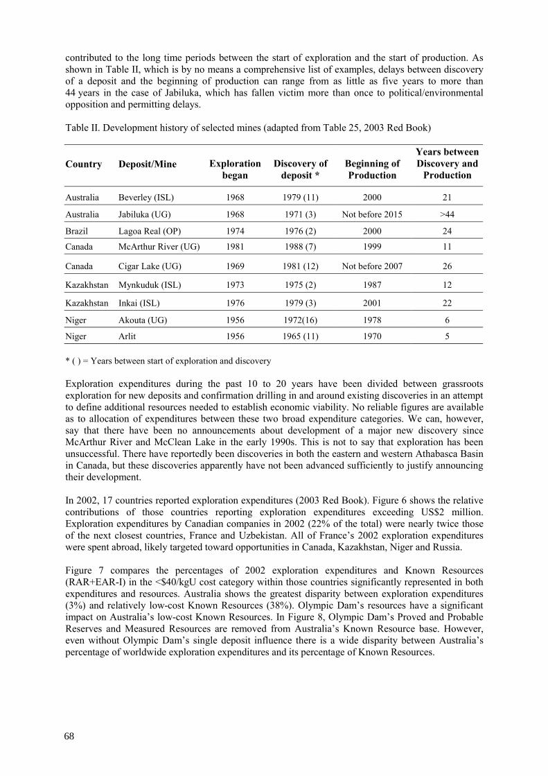
contributed to the long time periods between the start of exploration and the start of production. As shown in Table II, which is by no means a comprehensive list of examples, delays between discovery of a deposit and the beginning of production can range from as little as five years to more than 44 years in the case of Jabiluka, which has fallen victim more than once to political/environmental opposition and permitting delays. Table II. Development history of selected mines (adapted from Table 25, 2003 Red Book)
Country Deposit/Mine Exploration began
Discovery of deposit *
Beginning of Production
Years between Discovery and
Production
Australia Beverley (ISL) 1968 1979 (11) 2000 21
Australia Jabiluka (UG) 1968 1971 (3) Not before 2015 >44
Brazil Lagoa Real (OP) 1974 1976 (2) 2000 24
Canada McArthur River (UG) 1981 1988 (7) 1999 11
Canada Cigar Lake (UG) 1969 1981 (12) Not before 2007 26
Kazakhstan Mynkuduk (ISL) 1973 1975 (2) 1987 12
Kazakhstan Inkai (ISL) 1976 1979 (3) 2001 22
Niger Akouta (UG) 1956 1972(16) 1978 6
Niger Arlit 1956 1965 (11) 1970 5 * ( ) = Years between start of exploration and discovery Exploration expenditures during the past 10 to 20 years have been divided between grassroots exploration for new deposits and confirmation drilling in and around existing discoveries in an attempt to define additional resources needed to establish economic viability. No reliable figures are available as to allocation of expenditures between these two broad expenditure categories. We can, however, say that there have been no announcements about development of a major new discovery since McArthur River and McClean Lake in the early 1990s. This is not to say that exploration has been unsuccessful. There have reportedly been discoveries in both the eastern and western Athabasca Basin in Canada, but these discoveries apparently have not been advanced sufficiently to justify announcing their development. In 2002, 17 countries reported exploration expenditures (2003 Red Book). Figure 6 shows the relative contributions of those countries reporting exploration expenditures exceeding US$2 million. Exploration expenditures by Canadian companies in 2002 (22% of the total) were nearly twice those of the next closest countries, France and Uzbekistan. All of France’s 2002 exploration expenditures were spent abroad, likely targeted toward opportunities in Canada, Kazakhstan, Niger and Russia. Figure 7 compares the percentages of 2002 exploration expenditures and Known Resources (RAR+EAR-I) in the <$40/kgU cost category within those countries significantly represented in both expenditures and resources. Australia shows the greatest disparity between exploration expenditures (3%) and relatively low-cost Known Resources (38%). Olympic Dam’s resources have a significant impact on Australia’s low-cost Known Resources. In Figure 8, Olympic Dam’s Proved and Probable Reserves and Measured Resources are removed from Australia’s Known Resource base. However, even without Olympic Dam’s single deposit influence there is a wide disparity between Australia’s percentage of worldwide exploration expenditures and its percentage of Known Resources.
68

Canada (23)
China (6)
Egypt (6)Russia (9)
Uzbekistan (13)
France (13)
Others (3) Australia (3)
India (11)Kazakhstan (11)
Niger (3)
FIG. 6. Uranium exploration expenditures 2002 (Percentage of worldwide total). Canada, Russia and Uzbekistan show higher percentages of exploration expenditures relative to their resource percentages, while Australia, Kazakhstan and Niger show the reverse relationship. It is hard to draw firm conclusions from these relationships. Exploration in Canada’s Athabasca Basin is obviously attractive because of the potential for additional discoveries of high-grade unconformity-related deposits. Russia’s geologic diversity and relative sparseness of exploration may explain its high exploration expenditure percentage relative to Known Resources. Both Niger and Kazakhstan have large resource bases defined by past exploration, which may explain their lower expenditure levels. We should not expect an exact relationship between resources and exploration expenditures. Exploration in areas with poorly developed infrastructure and/or a harsh climate is inherently more expensive than where the infrastructure is better developed. All other factors being equal, exploration in the geologically complex environments of the unconformity-related deposits is inherently more expensive than exploration for flat lying sandstone deposits. One would, however, expect the prospect of relatively low-cost resources to attract a proportionate share of exploration dollars. The question of why Australia has not attracted more exploration dollars may find its answer in politics and a well organized environmental community opposed to uranium mining. In 2004, WMC Resources relinquished its rights to Yeelirrie, a 44 000 tU surficial deposit in Western Australia, with a potential production capacity of 2000 tU. Project economics clearly played a role in this decision, but so did politics. The Labour Party government is pushing to make Western Australia “nuclear free” — i.e. no uranium mining. Governments and attitudes change, but eliminating uranium mining from Western Australia would affect more than just Yeelirrie. Table III lists some of the other deposits in Western Australia where eventual development could potentially be delayed by government intervention. The combination of uncertainty surrounding development of Jabiluka and the potential cloud hanging over uranium mining in Western Australia could partially explain the seeming disparity between exploration expenditures and low-cost Known Resources.
69

0
5
10
15
20
25
30
35
40
Perc
enta
ge o
f Wor
ldw
ide
Tota
l
Australia Canada Kazakhstan Niger Russia Uzbekistan
Percent Exploration Expenditure Percent Known Resources
FIG. 7. 2002 exploration expenditures relative to Known Resources <$ 40/kgU cost cateogry.
0
5
10
15
20
25
Perc
enta
ge o
f Wor
ldw
ide
Tota
l
Australia Canada Kazakhstan Niger Russia Uzbekistan
Percent Exploration Expenditure Percent Know n Resources
FIG. 8. 2002 Exploration expenditures relative to Known Resources <$40/kgU cost category
(Olympic Dam resources removed from Australia total). Australia is by no means the only example where exploration expenditures do not match resources. Though the United States does not report resources in the <$40/kgU category it ranks seventh in the world in RAR in the <$80/kgU category, yet it reported only $352 000 in 2002 exploration expenditures. Well-organized environmental opposition to uranium mining in uranium resource-rich states like New Mexico likely contributes to the low level of exploration in the United States. In the recent past, depressed market prices provided very little economic incentive to directly confront environmental opposition to project development. The sharp increase in prices has started to provide that incentive. However, producers must be certain that this increase is not temporary but is indeed sustainable before they will commit development capital for new production capacity.
70

Table III. Western Australia deposits
Deposit Resources (tU) Average grade % U
Projected production capacity (tU)
Mining method
Yeelirrie 44 000 0.12 2000 Open Pit
Kintyre 29 600 0.21 1270 Open Pit
Manyingee 6650 0.1 400 ISL
Oobagooma 8400 0.1 400 ISL
Total 88 650 --- 4070 ---
5. Conclusions The addition of already identified new production capacity will likely forestall a projected shortfall between primary production capacity and supply requirements until 2012. The unlikely closure of Rossing in 2007 could, however, precipitate a shortfall as early as 2007-2008. As recently as 2002, secondary supply provided nearly half of total reactor uranium requirements. By 2020, however, the contribution from secondary supply could be as little as 15% of total demand, with primary supply providing the balance. The potential shortfalls in supply are not related to a shortage of uranium resources, at least not in the near term. Instead they reflect the possibility that there may not be sufficient production capacity available to get the resources to the marketplace. Market prices must be sufficiently high to provide incentive to develop new capacity, which returns us to the initial question — “how high will prices go and how sustainable is the price rise”. Producers must be confident in the sustainability of higher market prices before they will be willing to invest in new or expanded production capacity. The fact that a primary supply shortfall could occur in 2012 when combined with licensing periods of up to 10 years would suggest that the current price increase is sustainable. The answer to how high the market will go cannot be answered in absolute terms. However, presumably the price will eventually rise to a level sufficient to cover the production cost of the highest cost supply source needed to fill each new increment of unfilled demand.
REFERENCE
[1] OECD NUCLEAR ENERGY AGENCY, A Joint OECD/NEA-IAEA Publication, Uranium 2003: Resources, Production and Demand, 2003 Red Book, (2004).
71


SITE VISITS TO ROZNÁ, WISMUT AND STRÁZ
J.M. MCMURRAY Consulting Geologist, Littleton, Colorado, United States of America
(1) Rozná mine
The visit to the Rozná mine near Dolní Rožníka (55 km northwest of Brno), Czech Republic, took place on 2 September. The visit was hosted by DIAMO, State-owned Enterprise.
The Rozná mine/mill complex began operations in 1957, and is scheduled by government decree to shut down by 13 June 2005 after which DIAMO’s emphasis will shift from mining to rehabilitation and decommissioning. The Rozná mine is operated by GEAM Dolní Rožníka, a subsidiary of DIAMO. There are currently 475 workers at the Rozná complex, including 106 miners, 48 technical management personnel, and 340 workers distributed among the mill, surface building maintenance, etc. When mining stops in 2005, employment is expected to be reduced to about 150.
The Rozná deposit is a vein deposit located in the metamorphic complex of Western Moravia. The ore occurs in two parallel, west-dipping tectonic zones, one dipping at 70o and the other at 40–45o. The average thickness of the ore zones is about nine meters. The average grade of the ore is 0.25% U. Mining at Rozná is by underground methods. The deepest mine development is at about 1200 meters. Access to the ore is through seven shafts, two of which are used for transporting ore and personnel, with the remaining used for ventilation and equipment and supplies. The current mining method is underhand cut and fill, though mining methods have varied over time depending on geology and rock conditions. The ore is developed on 50-meter levels; ore blocks measure 50×50 meters. There are currently 13 ore blocks in operation. Mining recovery averages about 95%. Production averages about 600 tonnes of ore per day, or between 9 and 10 tonnes of ore per miner per 6.5-hour shift. Historically, mine development has resulted in 100 km of vertical mine workings (shafts, raises, etc.) and 500 km of horizontal workings (drifts, cross cuts, etc.) Total volume of material removed from the mine is about 16 million tonnes, including 15.5 million tonnes of ore. Historical production from the mine totals about 17.6 million kgU.
Ore from the mine is transported by truck to the mill, which currently has a capacity of about 350 000 tonnes of ore per year. At the peak of production at Rozná the mill could process up to 580 000 tonnes of ore annually. The Rozná mill uses an alkaline leach-ion exchange circuit; mill recovery averages 94%. The nominal capacity of the Rozná mill is 400 tU per year; 2003 production totalled 350 tU. The final product from the Rozna mill is (NH4)2U2O7, which contains about 70% U. Specifications of the final product vary with the requirements of the convertors.
As it looks to the future, Rozná’s main long-term problem will be reclamation of the tailings ponds and waste water treatment. There are two tailings ponds designated K1 and K2. The K2 pond is currently in operation and the K1 pond is being rehabilitated. Approximately 976 000 m3 of tailings “sludge” were deposited in the K1 tailings pond. The K2 pond currently covers an area of about 68 hectares and contains 9.5 million m3 of tailings.
The tour of the Rozná site included an underground mine tour of the 21st level at a depth of 1100 meters to observe mine development and mining methods. Another group of participants
73

toured the milling facility. All participants visited the wastewater treatment plant and waste rock rehabilitation work at the Olsi Drahonin mine, which operated between 1959 and 1989 and produced 3000 tU. Ore from the Olssi Drahonin operation was processed at the Rozná mill, so there are no tailings to contend with at the mine site. Therefore, the main rehabilitation concerns are waste rock piles and waste water treatment. The waste rock dump includes about 1.1 million m3 of material and covers an area of 12.5 hectares. The waste rock dump has been contoured, covered with a 30 cm-thick layer of soil and planted with trees and other vegetation. The waste rock rehabilitation effort has been successful and the area has been turned over to the forestry department of the Czech Republic. DIAMO’s only continuing responsibility at Olsi Drahonin is treatment of water draining from the mine and minor seepage from the waste rock pile. The Olsi Drahonin water treatment plant includes barium chloride treatment to remove radium and ion exchange columns to remove uranium. The loaded ion exchange resin is transferred to the Rozná mill for elution and regeneration.
(2) Wismut reclamation project
The visit to the WISMUT reclamation project near Chemnitz, Germany, took place on 2 and 3 September. The visit was hosted by WISMUT GmbH and was led by Messrs. Strucker, Paul and Barnekow. Dr. Alex Jakubick vice director of WISMUT also participated in the tour.
Approximately 232 000 tU were produced within the WISMUT production complex between 1946 and 1990. The total area covered by mining, milling and processing activities spanned about 100 km2 and included 5 underground mines, an open pit mine and 2 mills. A total of 240 million tonnes of ore and 760 million tonnes of waste rock were produced during this period. However, only minor rehabilitation was carried out during operations. In 1991, a programme was undertaken to evaluate rehabilitation and decommissioning requirements and to prepare a rehabilitation plan. Following the reunification of Germany, € 6.6 billion has been committed to rehabilitation of the WISMUT complex. Of that total, €3.7 billion were spent between 1991 and 2002. An estimated €1 billion will be spent between 2002 and 2007, and €1.76 billion after 2007.
WISMUT has five working areas including Ronneborg, Seelingstaadt, Königstein, Schlema-Alberga (Ore Mountains) and Dresden-Gittersee. Each of these main areas includes multiple rehabilitation projects including tailings ponds, waste rock dumps, mill decommissioning, etc. WISMUT currently employs about 2500 people compared to 45 000 in 1989. The WISMUT site visit included tours of the Helmsdorf tailings pond (which is managed by the Ronneborg unit) and the water treatment plant at the Königstein underground mine.
(a) Helmsdorf tailings pond. WISMUT has chosen the dry in situ rehabilitation method for the Helmsdorf tailings pond. The Helmsdorf pond covers an area of about 200 hectares and contains 49 million m3 of tailings from the Crossen alkaline leach mill. Helmsdorf is only one of several tailings ponds in the area, but it is by far the largest of the ponds associated with the Crossen mill. Remediation of two other nearby ponds, Dänkritz 1 and 2, is nearly completed. Helmsdorf is also well along in the remediation process, but there is still considerable work remaining, with final covering of the tailings expected to be completed by 2010.
The Helmsdorf pond, like most tailings impoundments contains tailings (sand sized material) deposited in “beaches” at the margins of the pond, slimes (water saturated very fine-grained material) deposited in the centre and free (surface) water. Disposal of the water, both freestanding and pore water is the main rehabilitation problem followed in complexity by covering and dewatering the tailings and re-contouring the tailings surface and dam. Prior to
74

start of remediation, there were approximately 7 million m3 of freestanding surface water. Today, that total has been reduced to about 300 000 m3, with over 8 million m3 of tailings pond water (surface and pore water) having already been treated. There also remains “several million m3” of pore water that will require treatment over time as the tailings compact. The surface water contains about 8 mg/l uranium and 1000 mg/l arsenic prior to treatment.
Though progress towards rehabilitation of the Helmsdorf pond is well advance, there were still excellent examples of the remediation procedure to be observed during the site visit. Covering of the tailings involves emplacement of an immediate cover to reduce radiation dangers, control dust and provide stability on which vehicles can move to spread the cover. The fine tailings, which are very weak and highly compressible, are covered with a geo-fabric stitched to vertical wick drains. The geo-fabric is in turn covered by a plastic geo-grid with a +2 cm grid or mesh. The geo-grid is currently being covered with 1.5 meters of waste rock, which has been crushed to –10 cm at the Crossen mill and moved 2 km by conveyor to the Helmsdorf site. Once the surface water has been removed and treated, a final cover of 1.5 meters of rock and soil will be emplaced to prevent influx of surface water. The red soil that is used in the final cover is locally derived from an open pit. The tailings surface will be re-contoured to 1:5 slope and the tailings dam will be contoured to a 1:4 slope. Final vegetation and disposition of the buried tailings surface is still being debated.
During the initial phase of the Helmsdorf reclamation, the regulatory authorities required that contaminants in the pond water be removed and stored separately. Ion exchange and membrane technology were used to remove uranium, radium and arsenic. The individual contaminate sludges were mixed with fly ash containing free lime derived from lignite-burning power plants and concrete and the resulting slurry was transported to small basins in the tailings pond. Beginning in 1995 the requirement to separately remove the contaminants was rescinded and today a combined treatment scheme is used. Two pipelines, each with 125 m3/hour capacity bring water from a pumping station at the tailings pond to the water treatment plant. The water is first “stripped” by adding acid to reduce the pH to 3.5 in order to break the uranium complex. Uranium is removed by lime, arsenic by FeCl3 and radium by BaCl. The resulting sludge is mixed with fly ash and cement and buried in small basins in the tailings pond just as before. Once the slurried sludge hardens, it is covered with a layer of gravel to control dust. Decanted water from the treatment plant is pumped through a 6 km-long pipeline and is released into the Zwickauer Mulde River. The quality of the decanted water is carefully monitored to ensure that it meets environmental standards.
Seepage water from the base of the tailings pond and the dam totals about 400 000 m3 annually. This water is captured by drainage boreholes and pumped back to the tailings pond. Once the freestanding pond water is completely removed and treated, pore water removal will continue by using drainage boreholes. In addition, seepage of pore water from the buried tailings will continue to be a problem for an indeterminate time into the future. Therefore, water treatment will be an ongoing part of the WISMUT remediation programme even after the tailings are covered. Water treatment could continue for between 25 and 30 years, but the length of time will vary from area to area depending on the rate at which contaminant levels reach environmentally acceptable levels.
(b) Königstein mine. Exploration in the Königstein area began in 1961. The Königstein ore is hosted in Cretaceous sandstones and the ore occurrence is very similar to that of the Stráz deposit in the Czech Republic. Access to the ore in the Königstein deposit was through 11 separate shafts that were connected by 112 km of underground workings. The tour was conducted by Mr. Kurtz, the manager of the overall Königstein operation with assistance from
75

other specialists. The Königstein mine began production in 1967 as a conventional underground mine. In 1967 it began to switch to underground block leaching. Peak production was achieved in 1975; the mine stopped production in 1991 after having produced about 19 000 tU. For underground leaching, the sandstone ore was blocked out into mining units (or blocks) by overlying and underlying drifts and crosscuts. Most of the ore blocks were rubblized by drilling and blasting. In more permeable parts of the deposit acid was injected directly into unbroken ore. The ore blocks varied in size depending on ore geometry, but they averaged about 10 m in thickness with lengths and widths ranging from 100 to 200 meters and 50 to 100 meters, respectively. Sulphuric acid, at a concentration of between 2 and 3 mg/l was injected into the broken ore for periods of up to three years. In total approximately 2 million m3 of acid were injected into the Königstein mine. Pregnant acid with a concentration ranging from 10 to 150 mg/l was collected in the drifts beneath the broken ore blocks and pumped to the surface for processing to remove the uranium. At the time production stopped approximately 2 million m3 of acidic solution remained in the pore spaces of the ore body. Ore recovery factors varied with the geology, but the overall average was in the range of 70% of in place metal. There are about 10 000 tU of resources remaining in the Königstein deposit.
The Königstein deposit, which has an area of about 6 km2, extends to within 600 meters of the Elbe River at its closest point. In addition, the ore occurs in an important aquifer used as a source of drinking water for the city of Dresden and other smaller towns and villages in the area. As a consequence, the potential environmental consequences of mining at Königstein were recognized early in the operation, and wastewater treatment began as early as 1970.
Treatment of acid mine water is one of WISMUT’s major remediation responsibilities. Accordingly, the tour focused on the Königstein water treatment plant. Acid mine waters are collected in a control drift, which has been constructed downdip from the lowest point of the ore body at the drainage point where mine waters would naturally collect. Water averaging about 35 mg/l of uranium is pumped from the control drift at about 365 m3/hour and passes directly through ion exchange columns to remove the uranium. Some of the iron is removed from the water as part of the resin rejuvenation process. Uranium is stripped from the ion exchange resin and is precipitated using H2O2. The yellowcake slurry is sold to General Atomics, which ships it to Comherex in France for conversion. Between 80 and 100 tU are recovered by the ion exchange circuit annually. If the production level drops below 15 tU per year, the ion exchange circuit will be bypassed and the water from the mine will go directly to the neutralization tanks. This lower limit is set by government regulators, and does not necessarily represent an economic cut off.
Once it has passed through the ion exchange columns the mine water is neutralized from an average pH of about 2.7 to between 7 and 7.5. This neutralization with lime removes residual uranium and other heavy metals (zinc, lead, cobalt and cadmium), arsenic and iron that were mobilized during the underground leaching process. The water is treated with BaCl to remove the radium before it goes to thickeners in which a flocculent is added to promote precipitation. The resultant precipitant collects at the bottom of the thickener tank and is swept by rotating blades to centrifugal pumps for water removal. The precipitated sludge, which contains uranium and other heavy metals, is disposed of on the waste rock pile, which will ultimately be covered.
The decanted water from the thickener flows to a holding pond with a capacity of 130 000 m3, in which any remaining suspended material is allowed to settle. There is sufficient free board to accommodate an additional 20 000 m3 in case release from the pond is interrupted for any
76

reason. Water is pumped from the holding pond through an in line “police” filter where it is analysed before being discharged into the Elbe River at a current rate of about 400 m3 per day. The water leaving the mine has an average uranium content of 35 mg/l; the water discharged into the Elbe River has an average uranium content of 0.1 mg/l.
(3) Stráz mine
In addition to presentation of technical papers at the meeting participants were given a one-half day tour of the Stráz ISL and Hamr underground mine rehabilitation projects. Between 1967 and 2000, the Stráz ISL operation injected more than 4.5 million tonnes of various kinds of acid (sulphuric, nitric and hydrofluoric) into the uranium-bearing Cenomanian (Cretaceous) aquifer, resulting in production of about 16 000 tonnes of uranium. Commercial mining operations continued through 1996, when the Straz remediation programme began.
The Stráz ISL operation covered an area of about 6.5 km2 and ultimately contaminated two groundwater aquifers, with the contaminated area covering approximately 270 million m2. One of the two contaminated aquifers, the shallow Turonian aquifer, supplies drinking water to nearby communities. The contaminated groundwater is not naturally attenuated, and if not contained it will ultimately lead to dispersal of contaminates over a large area. The goal of the Stráz rehabilitation effort is first to contain the spread of contaminates and secondly to return the quality of the aquifers to levels that comply with environmental standards of the Czech Republic. Two desalination plants are currently operating both of which recover uranium as part of the rehabilitation process. The ultimate cost of the Stráz rehabilitation project is projected to be USD 1.5 billion over the next 35 to 40 years.
The first stop on the Stráz ISL tour was the evaporator plant, which is part of the desalination circuit. The evaporators, which are located adjacent to the hydrometallurgical mill, treat water coming from the ISL well fields that has already passed through the ion exchange circuit. This water has average concentrations of 40 g/l SO4, 5 g/l Al and 1.5 g/l NH4. The resulting precipitate has the approximate chemical composition: NH4Al(SO4)2. The precipitate is further treated to produce AlSO4, which has commercial application as a flocculent in water treatment. The evaporator circuit operates at a volume of about 5 m3/minute. The cost to produce “clean water” from the evaporator circuit is about USD2/m3. This is only the cost of treatment at the evaporator and does not include the ion exchange or barium chloride treatment that precedes the evaporator circuit.
The second stop for the Stráz tour was the tailings impoundment, which covers an area of about 1.8 km2. The impoundment, which began operating in 1980, is divided into two equal sized areas. The total volume of tailings is 1.4 million m3. There is no freestanding water in either pond, with the last water having been pumped into the Hamr shaft in 2003. There is no covering on the tailings other than sludge produced from water treatment that helps prevent blowing dust. Internal and external drainage ditches have been constructed to intercept and divert seepage water from the tailings and surface drainage. No attempt has been made to dewater the fine tailings slimes and they are still relatively unstable with very low compressive strength.
Following the stop at the tailings impoundments, the tour visited three well fields in the Stráz block to observe various types of well completion and airlift and down hole electrical pumps in recovery wells. DIAMO stopped injecting acid at the ISL operation in 1992 and current operations are directed toward cleaning up contaminated aquifers and limiting the lateral and vertical spread of contaminants. During this process about 200 tU are produced annually. The Stráz ISL operations took place at depths of between 150 and 250 m below the surface. There
77

are eight deposits in all that are amenable to ISL extraction within the Stráz block. The average ore grade was about 0.05% U. Productivity within the ISL operation ranged from 4 to 10 kg/m2 (a Soviet method of expressing grade and thickness). The recovery factor was about 50% of in-place metal.
The final stop of the Stráz block tour was near shaft No. 3 of the Hamr No. 1 mine. Production from this mine totalled 11 700 tU from ore with an average grade of 0.1% U. The No. 3 shaft has been allowed to flood, so water treatment is the only activity remaining there. Neutral water from the shaft is clarified, filtered and run through ion exchange columns before being released into holding basins for final settling before being release into the Ploucnice River. Acid mine water, which resulted from migration of ISL leach fluids into the Hamr mine, is neutralized and chlorinated before undergoing the same final treatment as the neutral water. Sludge derived from mine water treatment is used as a temporary cover in the tailings impoundments.
78

LIST OF PARTICIPANTS Aikas, O.P. Geological Survey of Finland, P.O. Box 1237, FIN-70211 Kuopio, Finland Awati, A. Strategic Planning Group, Department of Atomic Energy, Anushakti Bhhavan, C.S.M. Marg, Mumbai – 400 001, India Bakarzhiyev, A.Ch. State Geological Enterprise, “Kirovgeology”, 8/9 Kikvidze Street, Kiev 01103, P.O. Box 160, Ukraine Bakarzhiyev, Y.A. State Geological Enterprise, “Kirovgeology”, 8/9 Kikvidze Street, Kiev 01103, P.O. Box 160, Ukraine Barnekow, U. Abteilung T 1.2, Engineering, Wismut GmbH, Jagdschänkenstrasse 29, 09117 Chemnitz, Germany Comsa, O. Centre of Technology and Engineering for Nuclear Project – CITON, Department of Nuclear Power and Nuclear Fuel Cycle Development, 111 Atomistilor Street, P.O. Box 5204-MG-04, Bucharest – Magurele, Romania Erdi-Krausz, G. Geo-Faber Rt., Esztergár L. u. 19, H-7633 Pécs, Hungary Fekete, F. Mecskérc Rt., Esztergár Lajos u. 19, 7633 Pécs, Hungary Horyna, J. State Office for Nuclear Safety (SUJB),
Senovazne námesti 9, CZ-110 00 Praha 1, Czech Republic
Jolly, J. COGEMA, DUM/DEX, 2 Rue Paul Dautier, B.P. 4, 78141 Velizy Villacoublay, France Knyazev, O. Federal Atomic Energy Agency, 24/26 Bolshaja Ordyaka, 119017 Moscow, Russian Federation Mansoor, M. Pakistan Atomic Energy Commission (PAEC), Atomic Energy Minerals Centre, P.O. Box 658, Feroze Pur Road, Lahore, Pakistan Maqsood, A. Pakistan Atomic Energy Commission (PAEC), Project Manager ISL M&P, Project Qubul Khel, P.O. Box 1, Isa Khel Mianwal, Pakistan
79

McMurray, J.M. International Atomic Energy Agency, Wagramer Strasse 5, P.O. Box 100, 1400 Vienna, Austria Navarra, P.R. Comision Nacional de Eenergia Atomica (CNEA), Azopardo 313, 5501 Godon Cruz, Mendoza, Argentina Németh, G. Mecsekerc Rt., Esztrgár Lajos u. 19, 7633 Pécs, Hungary Ousmane, A. Ministry of Mines and Energy, Im ONAREM, 5th Floor, P.O. Box 11 700, Niamey, Niger Paul, M. Technische Geschäftsführung, Wismut GmbH, Jagdschränkenstrasse 29, 09117 Chemnitz, Germany Schwarz-Schampera, U. Federal Institute for Geosciences and Natural Resources, Stilleweg 2, D-30655 Hannover, Germany Slezak, J. DIAMO, State-owned Enterprise, Straz pod Ralskem, Machova 201, CZ 47127 Straz pod Ralskem, Czech Republic Thoste, V. Bundesamt für Geowissenschaften und Rohstoffe (BGR), Stilleweg 2, D-30655 Hannover, Germany Vance, R.E. Natural Resources of Canada, Uranium and Radioactive Waste Division, Electricity Research Branch, 580 Booth Street, Ottawa, Ontario K1A 0E4, Canada Vostarek, P. DIAMO, State-owned Enterprise, Straz pod Ralskem, Machova 201, CZ-47127 Straz pod Ralskem, Czech Republic Welham, K. Rio Tinto plc, 6 St. James’s Square, London SW1Y 4LD, United Kingdom Zuo, Jianwei China Nuclear Uranium Corporation (CNUC), 1 Nansanxiang, Sanlihe, Xicheng District, P.O. Box 2102-9, 100822 Beijing, China
80