Embed Size (px)
Citation preview

Available online at www.sciencedirect.com
s 10 (2008) 140–150www.elsevier.com/locate/forpol
Forest Policy and Economic
Real versus perceived conflicts between restoration of ponderosa pine forestsand conservation of the Mexican spotted owl
John W. Prather a,✠, Reed F. Noss b, Thomas D. Sisk a,⁎
a Center for Environmental Sciences and Education, Northern Arizona University, Flagstaff, Arizona, 86011-5694, United Statesb Department of Biology, University of Central Florida, Orlando, Florida 32816-2368, United States
Received 17 February 2006; received in revised form 11 April 2007; accepted 24 July 2007
Abstract
Progress in implementing ecosystem approaches to conservation and restoration is slowed by legitimate concerns about the effects of suchapproaches on individual imperiled species. The perceived conflict between the restoration of fire-excluded forests and concomitant reduction ofdense fuels and high-severity wildfire, versus the recovery of endangered species, has led to a policy ambiguity that has slowed on-the-groundaction at a time when active management is urgently needed, both for ecosystem restoration and species conservation. The Mexican spotted owl(Strix occidentalis lucida) in the southwestern U.S.A. is emblematic of this perceived conflict, with numerous appeals and lawsuits focused on thespecies and vast acres of forest managed with habitat quality for this species in mind. We use spatial analysis across large landscapes in Arizona toexamine potential conflicts between the desire to reduce the likelihood of uncharacteristically severe wildfire and restore native fire regimes, andthe concurrent desire and legal mandate to manage forests for the recovery of the owl. Our spatially explicit analysis indicates that real conflictsbetween these management objectives exist, but that locations where conflicts might inhibit active forest management represent less than 1/3 of the811,000 ha study region. Furthermore, within the areas where conflicts might be expected, the majority of the forest could be managed in waysthat would reduce fire hazard without eliminating owl habitat. Finally, management treatments that emphasize ecosystem restoration mightimprove the suitability of large areas of forest habitat in the southwest that is currently unsuitable for owls. These results demonstrate that evenwhere policy conflicts exist, their magnitude has been overstated. Active restoration of dry forests from which fire has been excluded is compatiblein many areas with conservation and recovery of the owl. Identifying and prioritizing areas to meet the dual goals of ecosystem restoration andimperiled species conservation require a broad spatial approach that is analytically feasible but currently underutilized. Working together,conservation biologists, restoration ecologists, and forest managers can employ landscape-level spatial analysis to identify appropriate areas formanagement attention, identify suitable management practices, and explore the predicted consequences of alternative management scenarios onforests, fire ecology, and the fate of sensitive species of conservation concern.© 2007 Elsevier B.V. All rights reserved.
Keywords: Environmental policy; Forest management; Strix occidentalis lucida; Restoration ecology; Spatial analysis; Imperiled species
1. Introduction
The evolution of wildlife conservation has proceeded fromprotection of favored species, recreation areas, and hunting andfishing grounds, to conservation and restoration of ecosystems(Noss and Cooperrider, 1994; Redford et al., 2003). Restoration
⁎ Corresponding author. Tel.: +1 928 523 7183; fax: +1 928 523 7423.E-mail address: [email protected] (T.D. Sisk).
✠ Deceased.
1389-9341/$ - see front matter © 2007 Elsevier B.V. All rights reserved.doi:10.1016/j.forpol.2007.07.003
of ecosystem function and natural fire regimes has emerged asthe primary objective of private, state, and federal forestmanagers in the extensive ponderosa pine (Pinus ponderosa)forests of the arid southwestern USA (Friederici, 2003). After acentury of fire exclusion and heavy livestock grazing, more ofthe southwestern landscape is characterized by stands ofponderosa pine that are unusually dense and fire prone(Covington and Moore, 1994; Covington et al., 1994; Allenet al., 2002; Brown et al., 2004; Noss et al., 2006a). Theresulting increase in the frequency and severity of large, stand-replacing crown fires has placed human communities and

141J.W. Prather et al. / Forest Policy and Economics 10 (2008) 140–150
infrastructure at risk, while degrading forest ecosystems andwildlife habitat (Covington, 2003). Ecosystem restoration,typically involving aggressive thinning of dense stands ofsmall trees, followed by prescribed fire, is intended to returnponderosa pine forests to a more open structure, with fewer,larger trees (Mast et al., 1999; Covington et al., 1997; Mooreet al., 1999). Historically this structure was maintained byfrequent surface fires, favoring larger trees and more productiveherbaceous understories, whereas crown fires tended to beuncommon and localized (Covington and Moore, 1992, 1994).Restoration and fuels-reduction treatments are encouraged bythe Healthy Forests Restoration Act (HFRA) of 2003, butHFRA promotes a relatively narrow definition of restorationthat focuses almost exclusively on fuels (DellaSala et al., 2004;Schoennagel et al., 2004; Noss et al., 2006b).
Progress in carrying out actual forest restoration treatmentshas been slow, in part because restoration treatments, especiallythose involving mechanical thinning and prescribed burning,are controversial (Tiedemann et al., 2000; Wagner et al., 2000;Allen et al., 2002) and may conflict with actions to benefitparticular threatened and endangered species, as required by law(Noss et al., 1997). In addition, exurban development and theexpansion of the wildland–urban interface (Marzluff andBradley, 2003; Radeloff et al., 2005) in the southwest hasexacerbated the need for fuels reduction and increased theconflict between protection of human communities and habitatmanagement for wildlife. This has resulted in the suggestionthat a state of “analysis paralysis” (Bosworth, 2002) exists, whichprevents the implementation of beneficial forest management.
No species is more symbolic of the conflict between forestmanagement and species conservation than the spotted owl(Strix occidentalis). In ponderosa pine forests of the westernUSA, the northern spotted owl (S. o. caurina) and theMexican spotted owl (S. o. lucida), both of which are listed asthreatened under the U.S. Endangered Species Act, as well asCalifornia spotted owls (S. o. occidentalis) east of the SierraNevada crest, tend to inhabit areas of denser forest withingenerally open landscapes historically maintained by frequent,low-severity fires (Beier and Maschinski, 2003). In manycases fire exclusion may have increased the amount of suitablehabitat for spotted owls in the short-term (Huff et al., 2005).Stands suitable to the owls generally have high canopy closureand high basal area with large trees and multiple canopylayers. These stands are often found on north-facing slopesand in steep canyons, which burn less frequently under anatural fire regime than much of the rest of the landscape(Beier and Maschinski, 2003). Under fire exclusion policies ofthe past 100 years, some areas that once supported more openstands now more closely resemble owl habitat. Nevertheless,the increased area of dense forest that has developed since fireexclusion is more vulnerable to large, stand-replacing fires thatwill likely reduce the area of this partially anthropogenic foresttype and also eliminate historical owl habitat (Huff et al.,2005; Noss et al., 2006a). Indeed, the Rodeo-Chediski Fire inArizona affected 55 Mexican Spotted Owl Protected ActivityCenters, many of which are no longer occupied by owls(United States Forest Service, Region 3 Staff, pers. comm.),
and owl populations are likely to be compromised if largeportions of the landscape continue to experience high-intensitycrown fires (Jenness et al., 2004).
A widespread perception is that efforts to restore ponderosapine landscapes and reduce the risk of unnatural high-severityfire conflict with efforts to protect spotted owls and otherspecies associated with dense stands (Allen et al., 2002; Beierand Maschinski, 2003). However, many endangered speciesconflicts are more a matter of perception than reality (Nosset al., 1997). In the vast ponderosa pine ecosystem, in particular,the relatively small area occupied by imperiled species isunlikely to preclude ecosystem restoration efforts in general(Beier and Maschinski, 2003), albeit it might constrainparticular forest treatments in specific locations. Taking alandscape-level perspective (Sisk et al., 2005), we use the dryponderosa pine forests and Mexican spotted owl population ofthe western Mogollon Plateau of northern Arizona (USA) as acase study in the conflict between habitat management for anendangered species and restoration to reduce fire threat. Weshow that although some degree of conflict between ecosystemrestoration and species conservation is real, a considerableamount of restoration and fuels-reduction treatments can beaccomplished without negative impacts on owls.
In this study we examine the degree of spatial concordancebetween areas identified as high priority for aggressive thinningand prescribed fire, and areas supporting occupied or potentialhabitat for Mexican spotted owls. We model the likely impacts offorest restoration treatments across an 811,000-ha study area,explore the extent and location of potential conflicts betweenrestoration activities and owl habitat, and assess tradeoffs betweenowl habitat management and abatement of fire threat. In additionto identifying potential conflicts, we explore the possiblecompatibility of forest treatments and owl conservation, focusingon the hypothesis that well-designed forest restoration treatmentsmay conserve, and in some cases enhance, the quality of owlhabitat.
2. Methods
2.1. Study area
Our study area covers just over 800,000 ha of primarilyforested land on the western Mogollon Plateau, Arizona, begin-ning just north and west of Flagstaff and extending southeast tothe edge of the 180,000 ha Rodeo-Chediski burn of 2002(Fig. 1a). Elevation varies from approximately 1500m in canyonsalong the edge of the plateau, to over 3600m on the San FranciscoPeaks. The dominant vegetation is stands of nearly pure pon-derosa pine and pinemixedwith Gambel oak (Quercus gambelii).Scattered areas of Douglas-fir (Pseudotsuga menziesii), white fir(Abies concolor), and white pine (Pinus strobiformis) forest,pinyon–juniper (Pinus edulis and Juniperus spp.) woodlands,aspen (Populus tremuloides) groves, and open grasslands are alsopresent (Fig. 1a). The primary land manager in the region is theUSDA Forest Service, with parts of four national forests(Coconino, Kaibab, Tonto, and Apache-Sitgreaves) comprisingover 75% of the study area. The area includes the cities of
142 J.W. Prather et al. / Forest Policy and Economics 10 (2008) 140–150
Flagstaff and Williams, AZ, as well as many smallercommunities.
2.2. Spatial data layers
We developed a suite of spatial data layers for our analyses.All spatial data were converted to 90-m (0.81-ha) resolutionraster formats compatible with ArcGIS 9.x (ESRI Corp.,Redlands, CA) geographic information system (GIS) software.Analyses, primarily spatial overlays, were performed within the
Fig. 1. a) Vegetation types across the 811,000-ha ForestERA study area; b) wildland–c) predicted Mexican spotted owl habitat, as per the ForestERA model; d) areas predic
ArcGIS Spatial Analyst platform, through use of the rastercalculator and other standard tools and methodologies.
2.2.1. Vegetation layersIn 2004 the Forest Ecosystem Restoration Analysis (Forest-
ERA) project produced a set of spatially explicit maps ofvegetation composition and structure across the analysisarea. Layers representing dominant overstory vegetation, basalarea (m2/ha), and tree density (stems/ha) were developedusing Enhanced Thematic Mapper (ETM; year 2000; 30-m
urban interface (WUI) areas, areas upwind of communities, and wildland areas;ted to be under the purview of the Mexican spotted owl management guidelines.

143J.W. Prather et al. / Forest Policy and Economics 10 (2008) 140–150
resolution) imagery coupled with data collected at more than500 ground plots (Hampton et al., 2003; Sisk et al., 2006).These analyses were carried out using a classification tree(vegetation composition) or regression tree (basal area and treedensity) methodology (Breiman et al., 1984) in See5 and Cubistsoftware (Rulequest Research, St. Ives, NSW, Australia). Acanopy cover layer was developed using Digital OrthophotoQuads (DOQs) and a form of advanced exploratory dataanalysis (Xu et al., 2006). In this methodology each 1-m pixel inthe DOQ is classified as canopy foliage, shadow, or groundvegetation based on its spectral signature. Percent canopy coveris derived by determining the number of 1-m pixels identified ascanopy foliage within a larger window. To the best of ourknowledge these are the most accurate spatial data layers ofvegetation characteristics for the analysis area.
2.2.2. Physiographic layersA 30-m resolution digital elevation model (DEM) from the
United States Geological Survey (USGS) was used to derivespatial data layers representing slope and aspect. Owing to itscircular nature (00=3600), for some analyses the aspect layerwas converted to radians, and the sine and cosine were taken(Beers et al., 1966). This converts the aspect layer from acircular variable to two layers that have continuous valuesbetween 1 and −1. The sine function divides aspect into anorth–south component, while the cosine function dividesaspect into an east–west component.
2.2.3. Communities and wildland–urban interface layersWe developed a spatially-explicit data layer identifying
communities within the analysis area based on a layerrepresenting land ownership obtained from the Arizona LandResource Information System (ALRIS). From the landownership layer we identified private property areas that wereeither inside or contiguous with incorporated communities. Thecommunity layer was further modified by local experts duringtwo planning workshops held by the ForestERA project (Sisket al., 2006). During these workshops the experts added addi-tional private land parcels that contained developments thatwere either listed on the national registry of communities at riskfrom wildfire or had their own fire protection district. Based onthis community layer, we then developed two additional spatialdata layers that explicitly identify areas that are likely to beamong the highest priorities for fuels-reduction treatments in theimmediate future: a wildland–urban interface (WUI) layer and alayer representing areas upwind of communities. TheWUI layerwas developed using our interpretation of guidelines foridentification of the WUI found in the Healthy ForestRestoration Act of 2003. We considered areas to be part ofthe WUI if they were 1) within 0.8 km of a community (asidentified above), 2) within 2.4 km of a community and wereidentified as areas with “high fire hazard” (see below), or 3)were within 0.4 km of a major highway (Fig. 1b). In general, weonly eliminated areas within 2.4 km of a community if they didnot contain forest vegetation; our interpretation of the WUI istherefore conservative. Areas were considered to be upwind ofcommunities if they fell within 10 km of a community (as
identified above) and were upwind of the community in thedirection in which winds typically blow in the analysis areaduring the fire season (SSW or 210–2400; NOAA 2004;Fig. 1b).
2.2.4. Mexican spotted owl habitat layersWe used three different layers representing Mexican spotted
owl (hereafter MSO) habitat in our analyses. First, we created aMSO nesting and roosting habitat layer developed by theForestERA project based on a literature review and input fromlocal MSO experts, including members of the MSO recoveryteam (Fig. 1c). The ForestERA MSO habitat layer identifies thespatial extent of potential MSO nesting and roosting habitat asthose areas of pine–oak or mixed-conifer habitat with basal areaN17 m2/ha. In addition, areas of pure ponderosa pine on slopesN8° (∼14%) and with basal area N17 m2/ha are consideredhabitat. Potential habitat predicted by the model capturesapproximately 85% of the 132 georeferenced MSO nest sitesknown to exist within the analysis area. Because specificmicrosite characteristics (e.g., presence of very large oaks orconifers), which could not be mapped effectively across a largelandscape, appear to influence MSO nest site selection (Mayet al., 2004), this model overestimates the habitat used by MSO.
This model was refined using the Mahalanobis distancestatistic (Clark et al., 1993; Farber and Kadmon, 2003; hereafterM-distance) and vegetation and physiographic characteristics at132 georeferenced MSO nest sites. For this analysis basal area,tree stem density, canopy cover, slope, and sine and cosine ofaspect were determined at each nest site by extracting those datafrom the raster pixel corresponding to the nest site. M-distancevalues were then computed for all nest sites, and all other 90-mpixels across the analysis area, using the mean and covariancevalues from the nest site dataset. This was accomplished usingan extension for ArcView 3.x (Jenness Enterprises, Flagstaff,Arizona), which computes M-distance values for any landscapebased on a set of up to 8 input raster layers. The M-distancevalues were then placed into four categories that represent therange of values in which 50%, 75%, 90%, and 100% of the nestsites could be found. The areas covered by the four categories ofM-distance values were considered to be areas of high,moderate, low, and very low suitability for owls. The finalspatial layer representing categorical M-distance values was cutto the extent of potential MSO nesting habitat (ForestERA,unpublished).
To create our second layer we obtained a shapefileidentifying MSO Protected Activity Centers (PACs) from GISstaff at the USDA Forest Service (Coconino, Kaibab, andApache-Sitgreaves National Forests). Under the MSO recoveryplan (USFWS, 1995) the Forest Service is required to identifyapproximately 600 acres (∼240 ha) of the “highest quality”MSO habitat around areas either currently or historically used asnesting or roosting sites by owls. Each of these areas isdesignated as a PAC. The shapefile was converted to a rastercoverage using standard techniques.
For our third layer we created a spatial representation of areasthat would fall under the purview of the MSO recovery plan(USFWS, 1995). This layer was developed from ForestERA

Table 1Predicted effects of different treatment types used in our analyses, based onpercent reduction of basal area, tree stem density, and canopy cover
Type Mean (range) percent reduction
Basal area Tree stem density Canopy cover
Maintenance burn a 5 (0–10) 5 (0–20) 5 (0–10)Very low-intensity thin b 10 (5–20) 40 (30–50) 20 (5–20)Low-intensity thin c 20 (10–30) 50 (40–60) 20 (10–30)Intermediate-intensity thin d 40 (30–50) 65 (55–75) 30 (15–45)High-intensity thin e 60 (50–70) 80 (70–90) 40 (25–55)a Representative of a light “broadcast” burn, or fuels maintenance treatment.b Very light thinning, followed by a prescribed burn. Representative of a “very
light” thinning or fuels maintenance treatment targeting primarily ladder fuels.c Light thinning, followed by a prescribed burn. Representative of a “light”
restoration or fuels maintenance treatment.d Moderate-heavy thinning, followed by a prescribed burn. Representative of
a “moderate” to “full restoration, or moderate fuels reduction.e Heavy thinning, followed by a prescribed burn. Representative of a “full”
restoration, heavy fuels reduction, or multi-age group selection.
144 J.W. Prather et al. / Forest Policy and Economics 10 (2008) 140–150
vegetation data layers, in collaboration with members of theMSO recovery team, and represents a spatial interpretation ofhabitat as identified under the recovery plan (Fig. 1d). The planplaces MSO habitat into two categories, protected habitat andrestricted habitat, and recommends constraints on the types ofmanagement that may be undertaken in each of these categories.Protected habitat comprises areas identified as PACs (see above)as well as all areas of pine–oak or mixed-conifer habitat that fallwithin protected areas (e.g., wilderness, designated roadlessareas, national parks, or national monuments) or fall on slopesN40%. These areas may only be managed using low-intensityprescribed fire andwildland fire use (allowing previously ignitedfires to burn, when they meet management objectives), except inspecial circumstances (USFWS, 1995). Restricted habitat is anyother area identified as containing pine–oak or mixed-coniferhabitat. These areas may be managed with considerable latitude,provided that management treatments retain key owl habitatcomponents, such as large trees, downed logs, and potential nestsites (USFWS, 1995).
2.2.5. Fire hazard layersFire hazards are defined as the types and amounts of fuels
available for a fire to consume (Sampson et al., 2000). Whileground and ladder fuels influence the severity of understoryfires and their likelihood of climbing into the forest canopy,these elements of fire hazard are highly variable and difficult toassess over large areas (Sampson et al., 2000). At the landscapelevel, one of the most important components of fire hazardmodels is the amount and distribution of canopy fuels (Cruzet al., 2003), often described in terms of crown bulk density(hereafter CBD). As CBD increases, so does the likelihood ofsustaining an active crown fire (one that actively moves throughforest canopy as opposed to passive crown fire, in which sometrees may burn, but the fire does not spread through the canopy).Active crown fires are difficult to control or suppress. The value0.1 kg/m3 CBD has been identified by fire experts as a thresholdbelow which active crown fire is unlikely to occur (Agee, 1996;USDA Forest Service Fire Sciences Laboratory staff, pers.comm.), and this value has been supported by some empiricalstudies (Scott and Reinhardt, 2002). At values of 0.15 kg/m3
CBD or more, any crown fire is likely to actively spread throughthe canopy (Agee, 1996).
The ForestERA project developed a spatial data layerrepresenting CBD (kg/m3) for the entire analysis area. For themixed-conifer (includingmixed-conifer and aspenmixtures) andponderosa pine (including pine–oak and pine–aspen mixtures)vegetation types, CBDwas estimated using the ForestERA basalarea and tree density spatial data layers along with allometricequations developed by Cruz et al. (2003). The resulting valuesfor CBD in the analysis area ranged from near zero to about0.5 kg/m3 in these vegetation types. These values are similar tovalues for CBD obtained from empirical studies in the samevegetation types (Brown, 1978; Fulé et al., 2001a,b; Scott andReinhardt 2002). The CBD was set at 0.01 kg/m3 for pure aspenstands. In pinyon–juniper CBD was calculated as 0.001 kg/m3
per 1% of canopy cover. These values were modifications ofestimated CBD for aspen stands in the Pacific Northwest
(Pollard, 1972) and for pinyon–juniper woodlands on the GilaNational Forest (Keane et al., 2000). Although this methodologywas less defensible than that used for mixed-conifer andponderosa pine dominated areas, it appears to provide reasonablepredictions of fire behavior in these habitat types, which cover avery small portion (b1%) of the total study area.
For analysis purposes we classified fire hazard into threecategories based on CBD values: 1) low-moderate=0–0.1 kg/m3 CBD, 2) high=0.1–0.15 kg/m3 CBD, and 3) veryhigh=N0.15 kg/m3 CBD. We assumed that areas with CBDbelow 0.1 kg/m3 would generally be low priority areas forrestoration and fuels-reduction treatments, whereas areas above0.15 kg/m3 CBD would be of highest priority.
2.3. Treatment effects
Through literature review and expert input, the ForestERAproject has developed predictions of the potential effects ofvarious restoration and fuels-reduction treatments on foreststructural attributes (ForestERA, unpublished). Initially, themean effects of different treatments were described usingempirical data from before and after treatment on ponderosapine and drymixed-conifer stands inArizona (Fulé et al., 2001a,b,2002), Colorado (Lynch et al., 2000), and Montana (Scott, 1998).Forestry experts from Colorado State University and NorthernArizona University were then asked to describe the likely range ofvariation around the mean. These data were synthesized to createdescriptions of a final set of treatment types (Table 1).
We determined whether a treatment would affect MSOhabitat by applying the maximum predicted basal area reductionof a specific treatment on potential MSO nesting habitat anddetermining whether the treatment would reduce the basal areabelow the threshold value (17.0 m2/ha) for potential nestinghabitat. For example, areas with basal area values above18.9 m2/ha could receive maintenance burning without beingreduced below the threshold. The maximum basal areareduction expected from this type of treatment is 10%; thus,in locations with basal area of 18.9 m2/ha, this would reducebasal area to just over 17.0 m2/ha.

Table 2Area of low (b0.10 kg/m3) intermediate (0.10–0.15 kg/m3) and high (N0.15 kg/m3) crown bulk density (CBD) within the western Mogollon Plateau analysisarea, and within predicted Mexican spotted owl (MSO) habitat based on a) theForestERA model, b) areas under the purview of the MSO managementguidelines, and c) within MSO Protected Activity Centers (PACs)
Analysisarea
Totalhectares
Hectares ofCBD
Hectares ofCBD
Hectares ofCBD
N0.15 kg/m3 0.10–0.15 kg/m3 b0.10 kg/m3
Entire studyarea
811,100 265,900 270,100 275,100(32.8%) (33.3%) (39.5%)
ForestERAmodel
216,400 139,900 69,600 6,900(64.7%) (32.2%) (3.2%)
MSOguidelines
169,300 87,700 52,300 29,300(51.8%) (30.9%) (17.3%)
MSO PACs 64,500 38,500 17,200 8,800(59.7%) (26.7%) (13.6%)
145J.W. Prather et al. / Forest Policy and Economics 10 (2008) 140–150
We also determined whether different treatment types wouldaffect the suitability of owl habitat, as predicted using the M-distance statistic. We applied the mean reduction values for eachtreatment type to the basal area, tree density, and canopy coverlayers. The M-distance extension was then rerun using the samemean and covariance matrices created using the original nestsite dataset, the original slope and aspect layers, and themodified vegetation structure layers. The resulting M-distancelayer was then compared with the original layer. Areas in thenew layer with values N1 unit of distance higher than those inthe original layer were considered decreased in suitability, areaswith values that did not change by N1 unit of distance wereconsidered to have remained unchanged in suitability, and areaswith values N1 unit of distance lower than the original layerwere considered to have improved in suitability.
2.4. Example management scenarios
To examine options for reducing fire hazard around commu-nities we created three scenarios that ranged from completeprotection or enhancement of areas identified as MSO habitat,
Table 3Area of landscape treated (ha and percent by treatment type) within priorityareas (wildland–urban interface areas and areas up to 10 km upwind ofcommunities) across the western Mogollon Plateau, under three different forestmanagement scenarios covering 180,000 ha
Treatment type Scenario
Maximum fuelsreduction
Maximum owl habitatprotection
Owl habitatmitigation
High-intensitythin
16,800 (9.4%) 6900 (3.7%) 12,100 (6.7%)
Intermediate-intensity thin
7600 (9.8%) 8200 (4.7%) 10,900 (6.1%)
Low-intensitythin
25,000 (13.9%) 14,000 (7.7%) 17,300 (9.6%)
Very low-intensity thin
54,500 (30.4%) 38,400 (21.3%) 49,500 (27.5%)
Maintenanceburn
30,800 (17.2%) 53,300 (29.7%) 45,900 (25.5%)
No treatment 35,300 (19.2%) 59,200 (32.9%) 44,300 (24.6%)
to fire hazard reduction with minimal consideration for MSOhabitat. In each scenario we treated areas contained within theWUI designated under HFRA and/or the 10-km upwind vectorfrom communities at risk (hereafter priority areas). These areas,encompassing a total of 245,100 ha, are likely to be priorities fortreatment given current political and social values. Within theseareas we set a goal of reducing CBD values to below 0.1 kg/m3.We used CBD as our measure of fire hazard because it does notchange with differing weather conditions.
In all three scenarios we did not apply treatments to privateland, to areas with slope N40%, to specially designated areas(wilderness and roadless areas), or to vegetation types otherthan ponderosa pine and dry mixed-conifer (e.g., pinyon–juniper, aspen). These constraints are representative of those inreal-life scenarios and reduced the treatable area to 180,000 ha.
In the first scenario, “Maximum Fuels Reduction,” we usedthe minimum intensity of treatment necessary to reduce CBD tobelow 0.1 kg/m3 in each location (pixel) on the landscape. IfCBD was already below this threshold, no treatment wasapplied. In locations where CBD was so high that none of thetreatment models would reduce the value below the 0.1 k kg/m3
threshold, the treatment resulting in maximum reductionof CBD, high-intensity thinning, was applied. The onlyconsideration for MSO habitat in this scenario was that notreatments were applied in PACs.
In the second scenario, “Maximum Owl Habitat Protection,”we applied treatments as outlined in scenario 1 outside of areasidentified as MSO habitat (using the ForestERA model). WithinMSO habitat we applied treatments only if crown bulk densitywas above 0.1 kg/m3 and if those treatments would eitherimprove, or not significantly alter, MSO habitat. These rulesapplied even within MSO PAC areas. A treatment that wouldchange the M-distance value of the MSO habitat by more thanone unit was considered to have a significant impact. This valueis somewhat arbitrary, but a lesser change is unlikely to move anarea of habitat from one designation of quality to another.
In the final scenario, “Owl Habitat Mitigation,” we appliedtreatments as in scenario 2 within “high-quality” MSO habitat,and as in scenario 1 outside of MSO habitat and in “low-quality” MSO habitat. “High-quality” MSO habitat wasconsidered as those areas that had M-distance values withinthe range covered by the top 50% of MSO nest sites (Fig. 1c).
Table 4Mean crown bulk density values (kg/m3), before and after modeled foresttreatments, within priority areas (wildland–urban interface areas and areas up to10 km upwind of communities) under three forest management scenarios
Scenario WUIareas
Areas upwind ofcommunities
Allpriorityareas
Withintreatableareas
Pre-treatment 0.119 0.133 0.126 0.149Maximum fuelsreduction
0.086 0.089 0.087 0.096
Maximum owlhabitat protection
0.099 0.109 0.104 0.119
Owl habitatmitigation
0.093 0.010 0.096 0.109
146 J.W. Prather et al. / Forest Policy and Economics 10 (2008) 140–150
3. Results
3.1. Overlap of MSO habitat with priority areas for fuelsreduction
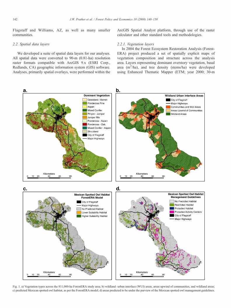
The western Mogollon Plateau study area covers 811,000 ha,of which 216,400 ha (26.7%) qualified as potential MSOnesting habitat by the ForestERA habitat model, 169,300 ha(20.9%) qualified for status as either protected (85,700 ha) or
Fig. 2. a) Percent reduction in crown bulk density in priority areas under the “maximbulk density in priority areas under the “maximum owl habitat protection”managemehazard after “maximum fire hazard reduction” management scenario; d) proportion oowl habitat protection” management scenario.
restricted (83,600 ha) habitat, and 64,500 ha (8.0%) fell withinPACs. Although the ForestERA habitat model identified agreater proportion of the study region as potential MSO habitat,it did not include all areas identified as protected or restrictedhabitat by our spatial interpretation of guidelines in the MSOrecovery plan (USFWS, 1995). A total of 275,600 ha (34.0%)was considered potential habitat by at least one model.
Crown bulk density was generally high in areas of MSOhabitat. Values for CBD averaged 0.18 kg/m3 (range 0.011–
um fire hazard reduction” management scenario; b) percent reduction in crownnt scenario; c) proportion of the landscape having low, intermediate, and high firef the landscape having low, intermediate, and high fire hazard after “maximum

Table 5Percent of western Mogollon Plateau landscape within priority areas (wildland–urban interface areas and areas up to 10 km upwind of communities) that are under the0.1 kg/m3 crown bulk density threshold before treatment and after treatment under three management scenarios
Scenario WUI areas Areas upwind of communities All priority areas Within treatable areas
Pre-treatment 36.7% 28.7% 32.6% 19.5%Maximum fuels reduction 62.8% 62.5% 62.6% 60.0%Maximum owl habitat protection 53.4% 48.1% 50.5% 43.6%Owl habitat mitigation 58.8% 56.2% 57.4% 52.9%
147J.W. Prather et al. / Forest Policy and Economics 10 (2008) 140–150
0.399) inside of MSO habitat and 0.107 outside of MSO habitat(range 0–0.502), as identified by the ForestERA potentialnesting habitat model. Within areas identified as PACs, CBDaveraged 0.168 (range 0–0.443). As would be expected, agreater proportion of the landscape within MSO habitat wasin the very high fire hazard (CBD N0.15 kg/m3) category(Table 2).
We identified 146,700 ha (18.1% of the study area) as lyingwithin HFRA WUI areas and 154,100 ha (19.0% of the studyarea) as lying upwind of communities. In total, 30.2% of thestudy area (245,000 ha) was identified as lying within the spatialextent of these priority areas. Within priority areas, 64,400 ha(26.3%) qualified as potential MSO nesting habitat, 49,200 ha(20.1%) qualified for status as either protected (20,800 ha) orrestricted (28,400 ha) habitat, and 16,500 ha (6.7%) fell withinPACs, with overlap among these categories. A total of80,000 ha (32.7%) was considered potential habitat by at leastone model, suggesting potential for conflict between hazardousfuels reduction and conservation of the MSO.
3.2. Changes in MSO habitat after treatment
The analysis of treatment types that could be used withinMSO habitat, based on the ForestERA potential nesting habitatmodel, revealed that only 39,500 ha (18.3%) of potential habitatcould not be treated at some level, without removing it fromprediction as potential habitat. Of the remaining habitat12,500 ha (5.8%) could be treated with intermediate-intensitythinning, 83,700 ha (38.7%) could be treated with low-intensitythinning, 46,100 ha (21.3%) could be treated with very low-intensity thinning, and 34,600 ha (16.0%) could be treated withmaintenance burning.
Application of the maximum treatment intensity wouldreduce MSO habitat suitability in nearly all MSO potentialnesting habitat. In some areas, however, treatments ofsomewhat lower intensity could be used to improve MSOhabitat quality. In total, 28,500 ha (13.2%) of potential MSOnesting habitat could be improved using treatments. Thisincludes 7,900 ha of low-intensity thinning, 8,000 ha of verylow-intensity thinning, and 12,600 ha of maintenance burn-ing. Another 95,500 ha (44.1%) of habitat could be treatedwith maintenance burning without substantially altering itssuitability.
3.3. Scenario results
After removal of constraint areas from consideration,180,000 ha were identified as treatable under each of the
three scenarios. Of this area 35,300 ha (19.6%) had CBD valuesbelow 0.1 kg/m3 before treatment. These areas were thereforeidentified as not in need of treatment to reduce canopy fuels,although treatments to reduce ladder fuels and litter, as could beaccomplished with maintenance burning, might be appropriate.Taking MSO habitat into consideration reduced the amount oftotal treatable area as well as the intensity with which manyareas could be treated (Table 3).
Each of the scenarios resulted in a substantial reduction inCBD values in priority areas (Table 4). The maximum fuelsreduction scenario reduced CBD by approximately 31% inpriority areas, whereas the scenario maximizing protection ofMSO habitat reduced CBD by approximately 18% (Table 4;Fig. 2a,b). However, we were not only interested in the percentreduction in CBD, but also the proportion of the landscape inwhich our targets for fire hazard reduction were met. Beforetreatment only 33% of the landscape had CBD values below0.1 kg/m3. In the maximum treatment scenario almost 63% ofthe landscape met this criterion, whereas almost 51% of thelandscape met this criterion in the scenario maximizingprotection of MSO habitat (Table 5; Fig. 2c,d).
4. Discussion
When formerly extensive ecosystems are reduced in area,fragmented, and altered in terms of natural processes andstructure, the remaining area is often difficult to manage in away that maintains the ecological integrity of the system as awhole while meeting the needs of all native species (Noss et al.,1995, 1997). In some cases not only do the needs of individualimperiled species conflict with one another, but restoration andmanagement goals for the ecosystem do not coincide withspecies-specific management objectives. For example, manage-ment of the Colorado River to simulate natural floods throughdam releases and restore beach habitat conflicts with objectivesunder the U.S. Endangered Species Act of 1973 to recoverpopulations of the endangered Kanab ambersnail (Oxylomahaydeni kanabensis) and the endangered southwestern willowflycatcher (Empidonax traillii extimus), both of which requireriparian vegetation that has increased in extent in some areassince completion of the dam (Stevens et al., 2001). In theEverglades of South Florida, not only do the water-depthrequirements of the endangered snail kite (Rostrhamussociabilis) and wood stork (Mycteria americana) conflict witheach other, there is little assurance that the multi-billion dollarEverglades restoration plan will succeed in saving either ofthese or many other imperiled species in the region (Adams,2006). For such reasons conservationists depend on the “safety
148 J.W. Prather et al. / Forest Policy and Economics 10 (2008) 140–150
net” of the Endangered Species Act and emphasize the habitatrequirements of individual species, but in so doing they maydelay or prevent restoration and management programs thatwould benefit the broader ecosystem (Noss et al., 1997).
Our study of ponderosa pine forests in northern Arizonaindicates that even where ecosystem restoration and speciesconservation objectives are in conflict, spatial analysis andmodeling approaches can be useful for designing strategies tominimize or eliminate the negative effects of restorationactivities on imperiled species habitat. In some cases carefullydesigned thinning and burning treatments may actually enhancehabitat quality for Mexican spotted owls, while aggressivetreating of adjacent, forest stands can reduce fire hazard acrossthe landscape, thus better protecting both human communitiesand owl habitat. Thus, far from being mutually exclusiveobjectives, forest restoration and the conservation of Mexicanspotted owls can be compatible given careful planning on abroad scale, as was suggested by Beier and Maschinski (2003)and Noss et al. (2006a). Although aggressive thinning mayreduce owl habitat quality in a specific location, when examinedfrom a landscape perspective, well-placed thinning andprescribed fire can enhance overall owl habitat quality, boththrough improving the quality of marginal stands and reducingthe likelihood of large losses of habitat from stand-replacing fire.
Mexican spotted owls occupy relatively dense ponderosapine, pine–oak and mixed-conifer forests that, after decades offire exclusion, tend to have an elevated likelihood of unchar-acteristically severe crown fire. There is an inherent conflict inmanagement objectives: protection of owl habitat appears notto coincide with goals for ecosystem restoration that involvereducing tree density by two-thirds or more of the presentdensity. On the other hand, not all dense forests constitute owlhabitat, and the reduction of tree densities in and near owl habitatshould result in minor impacts on owls if properly located.Approximately 34% of our study area constitutes potentialhabitat for Mexican spotted owls. A conservation strategy,designed to minimize management in MSO habitat, mightprohibit tree cutting and/or prescribed fire in these areas, leaving56% (534,000 ha) of the current priority areas accessible tointensive management. Even applying treatments to only the125,000 ha of area outside of MSO habitat and with CBD valuesabove 0.15 kg/m3 (see Table 2) would leave open managementoptions that might take 15 years or more to apply, given thecurrent capacity of regional forest managers (United StatesForest Service, Region 3 Staff, pers. comm.). Hence, protectionof spotted owl habitat and cautious implementation of fuels-reduction treatments over much of the landscape show sur-prisingly little potential for conflict in the near term.
Nevertheless, greater conflict arises near communities,where the demand for forest thinning and prescribed fire ismore urgent, given the potential losses to stand-replacementfire. Our analysis indicates that approximately 33% (80,000 ha)of forested area falling within a common definition of the WUIcan be considered potential habitat for MSO based on themodels used in these analyses. Restriction of intensive forestmanagement, such as mechanical thinning, in these areas couldseverely constrain management and compromise the protection
of human communities. Our analyses show, however, that evenwithout application of treatments that would seriously affectMSO habitat, managers could achieve approximately 60% ofthe fuels reduction that would be achieved if there were norestrictions on treatments. With reasonable tradeoffs consideredin planning, such as largely treating in lower suitability owlhabitat, this figure would rise to over 80% (Tables 4 and 5).Thus, there is considerable opportunity to move rapidly forwardon ecosystem restoration objectives in the most critical areasfrom a human perspective, with minimal threat to owls.
Even if treatments were applied only outside of MSO habitat,substantial progress could be made on fuels reduction. Ouranalysis suggests that treatments in areas outside of MSOhabitat increase the area unlikely to be at high risk for activecrown fire from 80,000 ha (33%) to 124,000 ha (63%, Table 5).In addition, with careful planning of the timing, intensity, andplacement of treatments, treated areas might slow the rate of firespread, allowing greater opportunity for effective fire suppres-sion, or for precipitation events that might extinguish anuncharacteristic crown fire (Agee et al., 2000; Finney, 2001).Nearby communities and MSO habitat could potentially benefitfrom these efforts.
Arguments that treatments within owl habitat are generallyunnecessary are short-sighted. Treatments within MSO habitatcould result in considerable benefits, both for communities andMSO habitat, albeit potentially more costly and difficult toimplement than treatments outside of MSO habitat. The MSOmanagement guidelines (USFWS, 1995) specifically allow forlow-intensity thinning and prescribed burning, even insidePACs, provided nest sites and their immediate vicinity areexcluded and disturbance to owls is minimized. Our analysissuggests that over 80% of potential MSO habitat within prioritytreatment areas could be treated without removing it frompotential use by owls, and over 50% of the habitat could betreated, primarily with the sorts of low-intensity treatmentrecommended in the guidelines, without reducing its suitabilityfor owls. In addition, the “restricted habitat” designation fromthe guidelines is meant to include areas that could be managedfor “future owl habitat” (USFWS, 1995). Such areas mayundergo very intense treatments if those treatments would resultin improved owl habitat over time.
Treatments such as prescribed burning and light understorythinning would seem to have little effect on fire threat.However, in the Rodeo-Chediski fire area, even low-intensityprescribed burning appears to have reduced crown fire severityand tree mortality (Wilmes et al., 2002; Finney et al., 2005).Analysis of post-fire burn severity reveals a clear pattern of lesssevere wildfire where fuels-reduction treatments had occurredduring the preceding 10 years. Furthermore, recent researchsuggests that owls can persist and successfully reproduce, atleast over the short-term, in areas that have been burned at lowto moderate severity (Bond et al., 2002; Jenness et al., 2004). Iflarge portions of the landscape burn at high severity, however,owl populations are unlikely to persist (Jenness et al., 2004).Thus, well-designed treatments that reduce the extent andseverity of wildfires while maintaining suitable owl habitat arelikely to be beneficial in the long-term.
149J.W. Prather et al. / Forest Policy and Economics 10 (2008) 140–150
In addition to the direct benefit of reducing the likelihoodof uncharacteristically severe fire, some treated areas can bemanaged for future owl habitat. Mexican spotted owls requirelarge diameter trees and snags for nesting and roosting sites, andmany areas currently suitable for owls are dominated by smallertrees. Low-intensity thinning of such areas would release waterand nutrients that would allow retained trees to grow morerapidly (Mast, 2003). Over time, and with proper management,such areas should become more similar to the historical forestsof the southwestern U.S. (Covington, 2003). These areas wouldhave lower tree density, but would likely maintain high basalarea and canopy cover as a result of the larger trees dominatingthe overstory. As these conditions are presumably those underwhich the MSO evolved, such areas would be likely to haveforest structural conditions favorable to owls. In addition,they are likely to benefit key prey species, including deermice (Peromyscus spp.), Mexican wood rat (Neotoma mex-icana), and Mexican vole (Mirotus mexicanus) (Block et al.,2005).
Arguments over whether treatments designed to reduce firehazard and restore forests to historical conditions can beundertaken while still providing protection to MSO populationshave been pursued in an abstract, aspatial, and largely theoreticalcontext. This has provided ample opportunities for all sides ofthe controversy to advance claims and counterclaims with littlereference to on-the-ground reality. Whereas some accuse theUSDA Forest Service of ignoring its own rules for the protectionof threatened and endangered species (e.g., Center for BiologicalDiversity, 2003), the Forest Service and other agencies blamelitigation and an overly bureaucratic approach to public landsmanagement for the impasse in implementing restoration plans(Bosworth, 2002). Spatial analysis puts the perceived conflicts“on the map” and allows all parties to see where and how muchimperiled species’ habitat is placed at risk by planned restorationactions. In our study, and we expect in many similar cases thathave yet to be assessed, the area of conflict is significant and real,but it occupies a smaller extent of the landscape than one mightexpect based on the sweeping statements and long-termcontroversy that characterize the management debate. Insteadof slowing on-the-ground management actions, spatial analysisincluding the modeling of management actions and their likelyeffects on forest structure and fire behavior, can providemanagers with a sharp focus on management objectives andthe tools needed for better coordinated and more effectiveplanning (Sisk et al., 2006). Analysis of perceived conflicts andexploration of the compatibility of active forest management andimperiled species conservation allowsmanagers to identify areaswhere conflict truly exists and design actions that are compatiblewith multiple management objectives. When conservation andrestoration planning is scaled-up from a stand to landscape scale,many apparent conflicts disappear as management actions arespatially partitioned and prioritized (Noss et al., 2006a).Importantly, as shown in our analyses, this approach canidentify large portions of the landscape where no conflict exists,and where relatively aggressive approaches to ecosystemrestoration can be pursued without placing sensitive species atsignificant risk.
Acknowledgments
John Prather passed away unexpectedly on February 20,2006, after this manuscript was submitted. His co-authors wishto acknowledge his scientific leadership and life-long commit-ment to conservation. We thank Haydee Hampton, Yaguang Xu,Brett Dickson and other members of the Forest EcosystemRestoration Analysis (ForestERA) project team for the use ofForestERA data layers in this study. The support for thisresearch was provided by the Ecological Restoration Institute atNorthern Arizona University, under the Southwest FireInitiative Task Order C, with funding provided by the DOIBureau of Land Management via the Department of Interior andRelated Agencies Conference Report 106-914.
References
Adams, J.S., 2006. The Future of the Wild. Beacon Press, Boston.Agee, J.K., 1996. The influence of forest structure on fire behavior. Proc. of
the 17th Annual Forest Vegetation Management Conference. Redding,CA, pp. 59–62.
Agee, J.K., Bahro, B., Finney, M.A., Omi, P.N., Sapsis, D.B., Skinner, C.N., vanWagtendonk, J.N., Weatherspoon, C.P., 2000. The use of shaded fuelbreaksin landscape fire management. For. Ecol. Manage. 127, 55–66.
Allen, C.D., Savage,M., Falk, D.A., Suckling, K.F., Swetnam, T.W., Schulke, T.P.,Stacey, P.B., Morgan, P., Hoffman, M., Klingel, J.T., 2002. Ecologicalrestoration of southwestern ponderosa pine ecosystems: a broad perspective.Ecol. App. 12, 1418–1433.
Beers, T.W., Dress, P.E., Wensel, L.C., 1966. Aspect transformation in siteproductivity research. J. For. 64, 691–692.
Beier, P., Maschinski, J., 2003. Threatened, endangered, and sensitive species.In: Friederici, P. (Ed.), Ecological Restoration of Southwestern PonderosaPine Forests. Island Press, Washington, D.C., pp. 306–327.
Block, W.M., Ganey, J.L., Scott, P.E., King, R., 2005. Prey ecology of Mexicanspotted owls in pine-oak forests of northern Arizona. J. Wildl. Manage. 69,618–629.
Bond, M.L., Guitierrez, R.J., Franklin, A.B., LaHaye, W.S., May, C.A.,Seamans, M.E., 2002. Short-term effects of wildfires on spotted owlsurvival, site fidelity, mate fidelity, and reproductive success. Wild. Soc.Bull. 30, 1022–1028.
Bosworth, D., 2002. Fires and forest health: our future is at stake. Fire Manage.Today 63, 4–11.
Breiman, L., Friedman, J.J., Olshen, R.A., Stone, C.J., 1984. Classificationand Regression Trees. Wadsworth and Brooks Publishing, Monterey,California.
Brown, J.K., 1978. Weight and density of crowns of Rocky Mountain conifers.USDA Forest Service Res. Pap. INT-RP-197.
Brown, R.T., Agee, J.K., Franklin, J.F., 2004. Forest restoration and fire:principles in the context of place. Cons. Biol. 18, 903–912.
Center for Biological Diversity, 2003. Federal court rules in favor ofenvironmental groups in suit to protect northern goshawk. News release,Nov. 18, 2003: http://www.biologicaldiversity.org/swcbd/search.html.
Clark, J.D., Dunn, J.E., Smith, K.G., 1993. A multivariate model of female blackbear habitat use for a geographic information system. J. Wild. Manage. 57,519–526.
Covington, W.W., 2003. The evolutionary and historical context. In: Friederici,P. (Ed.), Ecological Restoration of Southwestern Ponderosa Pine Forests.Island Press, Washington, D.C., pp. 26–47.
Covington, W.W., Moore, M.M., 1992. Postsettlement changes in natural fireregimes: implications for restoration of old-growth ponderosa pineforests. In: Kaufman, M.R., Moir, W.H., Bassett, T.D. (Eds.), Old-growthForests in the Southwest. USDA Forest Service Gen. Tech. Rep. RM-GTR-213, pp. 81–99.
Covington, W.W., Moore, M.M., 1994. Southwestern ponderosa foreststructure: changes since Euro-American settlement. J. For. 92, 39–47.

150 J.W. Prather et al. / Forest Policy and Economics 10 (2008) 140–150
Covington,W.W., Everett, R.l., Steele, R., Irwin, L.L., Daer, T.A., Auclair, A.N.D.,1994. Historical and anticipated changes in forest ecosystems of the InlandWest of the United States. J. Sustain. For. 95, 13–63.
Covington, W.W., Fulé, P.Z., Moore, M.M., Hart, S.C., Kolb, T.E., Mast, J.N.,Sackett, S.S., Wagner, M.R., 1997. Restoring ecosystem health in ponderosapine forests of the southwest. J. For. 95, 23–29.
Cruz, M.G., Alexander, M.E., Wakimoto, R.H., 2003. Assessing canopy fuelstratum characteristics in crown fire prone fuel types of western NorthAmerica. Int. J. Wild. Fire 12, 39–50.
DellaSala, D.A., Williams, J.E., Williams, C.D., Franklin, J.F., 2004. Beyondsmoke and mirrors: a synthesis of fire policy and science. Cons. Biol. 18,976–986.
Farber, O., Kadmon, R., 2003. Assessment of alternative approaches forbioclimatic modeling with special emphasis on the M-distance. Ecol. Model.160, 115–130.
Finney, M.A., 2001. Design of regular landscape fuel treatment patterns formodifying fire growth and behavior. For. Sci. 47, 201–228.
Finney, M.A., McHugh, C.W., Grenfell, I.C., 2005. Stand- and landscape-leveleffects of prescribed burning on two Arizona wildfires. Can. J. For. Res. 35,1714–1722.
Fulé, P.Z., Waltz, A.E.M., Covington, W.W., Heinlein, T.A., 2001a. Measuringforest restoration effectiveness in hazardous fuels reduction. J. For. 99, 24–29.
Fulé, P.Z., McHugh, C., Heinlein, T.A., Covington, W.W., 2001b. Potential firebehavior is reduced following forest restoration treatments. In: Vance, G.K.,Edminster, C.B., Covington, W.W., Blake, J.A. (Eds.), Ponderosa PineEcosystems Restoration and Conservation: Steps Toward Stewardship.USDA Forest Service Proc. RMRS-P-22, pp. 28–35.
Fulé, P.Z., Covington, W.W., Smith, H.B., Springer, J.D., Heinlein, T.A.,Huisinga, K.D., Moore, M.M., 2002. Comparing ecological restorationalternatives: Grand Canyon, Arizona. For. Ecol. Manage. 170, 19–41.
Friederici, P., 2003. Ecological Restoration of Southwestern Ponderosa PineForests. Island Press, Washington, D.C.
Hampton, H.M., Xu,Y., Prather, J.W.,Aumack, E.A., Dickson, B.G.,Howe,M.M.,Sisk, T.D., 2003. Spatial tools for guiding forest restoration and fuel reductionefforts. Proc. of the 23rd Annual Environmental Systems Research Institute(ESRI) International User Conference. CD-ROM.
Huff, M.H., Seavey, N.E., Alexander, J.D., Ralph, C.J., 2005. Fire and birds inmaritime Pacific Northwest. Stud. Avian Biol. 30, 46–62.
Jenness, J.S., Beier, P., Ganey, J.L., 2004. Associations between forest fire andMexican spotted owls. For. Sci. 50, 765–772.
Keane, R.E., Mincemoyer, S.A., Schmidt, K.M., Long, D.G., Garner, J.L., 2000.Mapping vegetation and fuels for fire management on the Gila NationalFor1est complex, New Mexico. USDA Forest Service Gen. Tech. Rep.RMRS-GTR-46-CD.
Lynch, D.L., Romme, W.H., Floyd, M.L., 2000. Forest restoration insouthwestern ponderosa pine. J. For. 98, 17–24.
Marzluff, J.M., Bradley, G.A., 2003. Ecological restoration in the urban-wildlandinterface. In: Friederici, P. (Ed.), Ecological Restoration of SouthwesternPonderosa Pine Forests. Island Press, Washington, D.C., pp. 353–370.
Mast, J.N., 2003. Tree health and forest structure. In: Friederici, P. (Ed.),Ecological Restoration of Southwestern Ponderosa Pine Forests. IslandPress, Washington, D.C., pp. 215–232.
Mast, J.N., Fulé, P.Z., Moore, M.M., Covington, W.W., Waltz, A.E.M., 1999.Restoration of presettlement age structure of an Arizona ponderosa pineforest. Ecol. App. 9, 228–239.
May, C.A., Petersberg, M.L., Gutierrez, R.J., 2004. Mexican spotted owl nestand roost-site habitat in northern Arizona. J. Wild. Manage. 68, 1054–1064.
Moore, M.M., Covington, W.W., Fulé, P.Z., 1999. Reference conditions andecological restoration: a southwestern ponderosa pine perspective. Ecol.App. 9, 1266–1277.
Noss, R.F., Cooperrider, A., 1994. Saving Nature's Legacy: Protecting andRestoring Biodiversity. Defenders of Wildlife and Island Press, Washington,D.C.
Noss, R.F., LaRoe, E.T., Scott, J.M., 1995. Endangered Ecosystems of theUnited States: A Preliminary Assessment of Loss and Degradation. Biol.Rep. 28. USDI National Biological Service, Washington, DC.
Noss, R.F., O'Connell, M.A., Murphy, D.D., 1997. The Science of ConservationPlanning: Habitat Conservation under the Endangered Species Act. IslandPress, Washington, D.C.
Noss, R.F., Beier, P., Covington, W.W., Grumbine, R.E., Lindenmayer, D.B.,Prather, J.W., Schmiegelow, F., Sisk, T.D., Vosick, D.J., 2006a. Recom-mendations for integrating restoration ecology and conservation biology inponderosa pine forests of the southwestern USA. Rest. Ecol. 14, 4–10.
Noss, R.F., Franklin, J.F., Baker, W.L., Schoennagel, T., Moyle, P.B., 2006b.Managing fire-prone forests in the western United States. Frontiers Ecol.Environ. 4, 481–487.
Pollard, D.F.W., 1972. Above-ground dry matter production in three stands oftrembling aspen. Can. Jour. For. Res. 27, 27–33.
Radeloff, V.C., Hammer, R.B., Stewart, S.I., Fried, J.S., Holcomb, S.S.,McKeefry, J.F., 2005. The wildland-urban interface in the United States.Ecol. App. 15, 799–805.
Redford, K.H., Coppolillo, P., Sanderson, E.W., da Fonseca, G.A.B., Dinerstein,E., Groves, C., Mace, G., Maginnis, S., Mittermeier, R., Noss, R., Olson, D.,Robinson, J.G., Vedder, A., Wright, M., 2003. Mapping the conservationlandscape. Cons. Biol. 17, 116–131.
Sampson, R.N., Atkinson, R.D., Lewis, J.W., 2000. Mapping Wildfire Hazardsand Risks. The Haworth Press, New York.
Schoennagel, T., Veblen, T.T., Romme, W.H., 2004. The interaction of fire,fuels, and climate across Rocky Mountain forests. Bioscience 54, 661–676.
Scott, J.H., 1998. Fuel reduction in residential and scenic forests: a comparisonof three treatments in a western Montana ponderosa pine stand. USDAForest Service Res. Pap. RMRS-RP-5.
Scott, J.H., Reinhardt, E.D., 2002. Estimating canopy fuels in conifer forests.Fire Manage. Today 62, 45–50.
Sisk, T.D., Savage, M., Falk, D.A., Allen, C.D., Muldavin, E., McCarthy, P.,2005. A landscape perspective for forest restoration. J. For. 103, 319–320.
Sisk, T.D., Prather, J.W., Hampton, H.M., Aumack, E.N., Xu, Y., Dickson, B.G.,2006. Participatory landscape analysis to guide restoration of ponderosa pineecosystems in the American Southwest. Land. Urb. Plan. 74, 300–310.
Stevens, L.E., Ayers, T.J., Bennett, J.B., Christensen, K., Kearsley, M.J.C.,Meretsky, V.J., Phillips III, A.M., Parnell, R.A., Spence, J., Sogge, M.K.,Springer, A.E., Wegner, D.L., 2001. Planned flooding and Colorado Riverriparian trade-offs downstream from Glen Canyon Dam, Arizona. Ecol.Appl. 11, 701–710.
Tiedemann, A.R., Klemmedson, J.O., Bull, E.L., 2000. Solution of forest healthproblems with prescribed fire: are forest productivity and wildlife at risk?For. Ecol. Manage. 127, 1–18.
U.S. Fish and Wildlife Service (USFWS), 1995. Recovery Plan for the MexicanSpotted Owl (Strix occidentalis lucida). U.S. Fish and Wildlife Service,Albuquerque, New Mexico.
Wagner, M.R., Block, W.M., Geils, B.W., Wenger, K.F., 2000. Restorationecology: a new forest management paradigm or another merit badge forforesters? J. For. 98, 22–27.
Wilmes, L., Martinez, D., Wadleigh, L., Denton, C., Geisler, G., 2002. Apache-Sitgreaves National Forests Rodeo-Chediski fire effects summary. Apache-Sitgreaves National Forest, Springerville, AZ.
Xu, Y., Prather, J.W., Hampton, H.M., Dickson, B.G., Aumack, E.N., Sisk, T.D.,2006. Advanced exploratory data analysis for mapping regional canopycover. Phot. Eng. Rem. Sens. 72, 31–38.