Embed Size (px)
Citation preview

REAL-TIME RADAR AVALANCHE DETECTION OF A LARGE DETECTION ZONE FOR ROAD SAFETY IN NORWAY
Andreas Persson1, Martin Venås1, Tore Humstad 2, Lorenz Meier3
1 Norwegian Public Roads Administration, Northern Region, 9008 Tromsø, Norway 2 Norwegian Public Roads Administration, Directorate of Public Roads, 0667 Oslo, Norway
3 Geopraevent AG, Technoparkstrasse 1, 8005 Zurich, Switzerland
ABSTRACT: The project involves testing a long-range and wide-angle Doppler radar for detection of ava-lanches, as a part of an early warning system planned for County Road 293 at Holmbuktura, Troms, North-ern Norway. The avalanche-prone road through Holmbuktura is the only access road to an area inhabited by approx. 100 permanent and 100 weekend inhabitants. The average traffic through Holmbuktura is around 200 vehicles per day. Possible mitigation measures include an 800-1’000 m long tunnel or an ava-lanche protection gallery of similar length, both involving costs between 30 and 35 Mio Euro. The Norwegian Public Roads Administration (NPRA) is therefore evaluating cheaper solutions with a better cost-benefit ratio, among them long-range and wide-angle Doppler radars with automatic road closure to protect vehi-cles from being caught by avalanches. During the two test winters, Long-range, wide-angle Doppler radar has proven to detect avalanches with sufficient warning time for road closure
KEYWORDS: Early warning system, Doppler radar, Long range, Wide angle, Avalanche detection, Holmbuktura,
1. INTRODUCTION
1.1 Situation
The avalanche-prone road through Holmbuktura is the only access road to an area inhabited by ap-prox. 100 permanent and 100 weekend inhabitants. The average traffic through Holmbuktura is around 200 vehicles per day. The avalanche-exposed part of the road is more than 1 km long and consists of two main avalanches gullies measuring around 250 m along the road in the north, and 500 m in thesouth area (figure 1). The altitude difference be-tween release area and the road is up to 1300 me-ters. Avalanches hit the road 2-3 times each winter on average according to the Norwegian nationalroad database (data updated 2018).
The mitigation today consists of continuously eval-uating the avalanche risk and closing the road whenever the risk is considered too high. The diffi-culties of this approach lie within the fact that theroad should stay open as much as possible, making it a difficult and dangerous combination. Statisti-cally, more than 70% of the avalanches in the past
have hit the road when it was open. Luckily, no ac-cidents have occurred so far, but there has been several close calls. Once in the 1970´s, the school bus was trapped between two avalanches.
Figure 1: The avalanche area consists of two main ava-lanches gullies: the north gully and the south gully. Be-tween them is a safe spot with no avalanche activity reg-istrated. Photo: Ole-André Helgaas.
Possible mitigation measures include an 800-1’000meter long tunnel or an avalanche protection gal-lery of similar length, both involving costs between 30 and 35 Mio Euro. The Norwegian Public Roads Administration (NPRA) is therefore evaluating cheaper solutions with a better cost-benefit ratio,
* Corresponding author address:Andreas Persson, Norwegian Public Roads Ad-ministration, Killengreens gate 6, 9008 Tromsø, Norway; tel: +47 97407901 email: [email protected]
Proceedings, International Snow Science Workshop, Innsbruck, Austria, 2018
597

among them real-time avalanche detection with au-tomatic road closure to protect vehicles from being caught by an avalanche.
For such an early warning system to work effi-ciently, it is important that the warning time (detec-tion and avalanche runout time) is longer than the time it takes for a vehicle to travel between the clos-ing barriers. Hence, long avalanche paths in com-bination with short road segments are most suita-ble” Avalanches where simulated and run-out times were estimated during pre-investigations (Hellum 2017). These simulations showed that there is enough time to pass only one of the ava-lanche gullies before the avalanche hits the road (table 1). Therefore, each gully has to have their own set of traffic lights/barriers.
1.2 Challenges
One of the biggest challenges for reliable, fast and automatic avalanche detection is the size of the av-alanche area in Holmbuktura. The area measures approximately 4 km2, making it difficult to install lo-cal detection technologies like for example geo-phones. Avalanche detection with long-range and wide-angle Doppler radars has proven to be suc-cessful in locations in the Alps at the start of this project (Meier 2016), but only radars with detection distances of up to 2 km were operational for ava-lanches at the time. A radar in Holmbuktura has to be able to detect and track an avalanche in a dis-tance of up to 3,5 km, and with an altitude differ-ence of 1300 meters. Furthermore, weather condi-tions can be harsh involving heavy snowfall, rain, strong winds, cold and icy conditions with long, dark polar winter nights. It is therefore essential that the radar is working even during periods of bad weather, as these also represent the conditions when avalanches are most likely to happen.
2. PROJECT SETTINGS
2.1 The goals
From February 2017 to June 2018, we tested a new type of radar in Holmbuktura. The goal of the test project was to evaluate if long-range Doppler radars are suitable as a cost-effective mitigation method to ensure safe travels through the avalanche-exposed area. For this evaluation, the following questions needed to be answered:
Can the radar detect and track an ava-lanche reliably and detailed enough for in-stalling a high quality early warning sys-tem?
How much warning time do we actually get before the avalanche hits the road?
How will the radar cope with the harsh weather conditions in Northern Norway?
2.2 Set up/design
The radar has a range of approx. 4 km and a field-of-view of 90 degrees horizontally and 15 degrees vertically (Meier 2018), which covers most of the avalanche area in Holmbuktura. The radar should detect any avalanches of size 2 or larger (EAWS classification) according to detection criteria given in the project. The position of the radar was deter-mined based on both visibility of the release zones and access to permanent power supply (figure 2).
Figure 2: The simulated radar coverage is shown. Col-oured areas are monitored by the radar. Colour indicates distance in meters. The red dot is the position of the ra-dar. Figure is taken from Geopraevent project report (Meier 2018).
The radar was installed in February 2017. To verify detections, we also installed a remotely controllable PTZ camera and a thermal camera. The radar sys-tem sent SMS messages immediately after it de-tected an avalanche. A few minutes after the ava-lanche, the radar sent another SMS with an esti-mate if the avalanche reached the road or not. The goal of this service was to provide road personnel with and early warning, but also to evaluate the im-plementation of traffic lights with automatic road closure and reopening, which is planned for 2019.
Proceedings, International Snow Science Workshop, Innsbruck, Austria, 2018
598

Figure 3: Radar installation (February 2017). To verify de-tections, a remotely controllable PTZ camera and a ther-mal camera were installed additionally. Photo: Andreas Persson
3. RESULTS
3.1 Detection
The radar system successfully detected 88 small to large avalanches during the two test winters (Meier, 2018). Of these avalanches, three hit the road. 16 % of all avalanches were detected in good visibility, 33 % in poor visibility due to bad weather condi-tions, and 51 % of the detections were made in dark conditions (Meier, 2018).
Figure 3: Some numbers from the project report provided (Meier 2018).
As many of the avalanches occurred in bad weather and poor visibility, it was challenging to verify the detections. Nevertheless, as many as 32 ava-lanches were identified by using the cameras and field observations. The avalanches not verified in the field, were confirmed manually by analysing ra-dar raw data and comparing them to verified
events. The data revealed that 3 out of the 88 de-tections where probably false alarms, or very small events (Meier 2018).
Furthermore, no missed avalanches where discov-ered, even though geologists, contractors and local inhabitants observed the site nearly daily, looking for any avalanches that the radar might have missed.
3.2 Weather conditions and downtime
Most of the downtime of the radar happened during the first test winter in periods of bad weather. The major cause was due to problems with snow and ice accumulating on the radar and blocking the ra-dar signal. This resulted in a downtime of totally 21.3 hours. A radar upgrade solved this problem before the start of the second test winter. This mod-ification reduced the downtime to as little as 1.7 hours during the second test winter.
3.3 Warning Time
Three avalanches happened to cross the road. Ra-dar logs where analysed to determine the warning time between radar detection and the time the ava-lanche hit the road (Table 1). All these avalanches happened during more or less good visibility. Therefore, camera images where available and the time when the avalanche reached the road could be accurately determined from photos. The time the avalanches hit the road is here the time when the powder cloud reached the road. In reality, the dense part usually follows some seconds later.Therefore, the warning time actually is a few sec-onds longer.
In all three cases the given warning time is sufficient for a vehicle driving at a speed of at least 60 km/h (table 1). The given warning time is also better than what initially was expected from the simulations.
Table1: Vehicle travel time compared to simulated ava-lanche runout time and given warning time from ava-lanche detection until the avalanche hits the road.
Date of ava-lanche/Ava-lanche gully
Vehicletravel time at 60 km/h
Simulated ava-lanche runout time
Warning time given (Detection and runout time)
5 Dec 2017/North
24s 38s 53s
29 Mar 2018/South
42s 48s 47s
31 Mar 2018/South
42s 48s 57s
Proceedings, International Snow Science Workshop, Innsbruck, Austria, 2018
599
3.4 Data processing
The radar logs tell us that the radar needed 3-5 sec-onds to detect the avalanches before the signals were sent to the receiver. During the test project, the receiver was an SMS that were sent out. In the future, traffic lights/barriers will receive the signal.
4. CONCLUSION AND DISCUSSION
4.1 Test project
The radar detected 88 avalanches during the two test winters. The downtime was reduced to as little as 1.7 hours during the second test winter. No missed avalanches where discovered. The SMS service worked well and provided road personnel with an increased safety, and provided NPRA with updated information about avalanche activity and understanding of the avalanche danger.
All three avalanche events that crossed the road, show that the time available for warning is suffi-cient, and in some cases longer than what was es-timated from the avalanche simulations (Table 1).
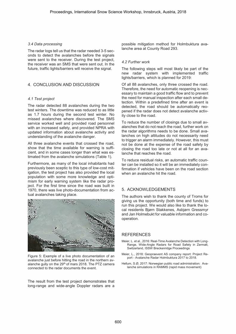
Furthermore, as many of the local inhabitants had previously been sceptic to this type of low-cost mit-igation, the test project has also provided the local population with some more knowledge and opti-mism for early warning system like the radar pro-ject. For the first time since the road was built in 1970, there was live photo-documentation from ac-tual avalanches taking place.
Figure 5: Example of a live photo documentation of an avalanche just before hitting the road in the northern av-alanche gully on the 29th of mars 2018. The PTZ camera connected to the radar documents the event.
The result from the test project demonstrates that long-range and wide-angle Doppler radars are a
possible mitigation method for Holmbuktura ava-lanche area at County Road 293.
4.2 Further work
The following steps will most likely be part of the new radar system with implemented traffic lights/barriers, which is planned for 2019:
Of all 88 avalanches, only three crossed the road. Therefore, the need for automatic reopening is nec-essary to maintain a good traffic flow and to prevent the need for manual inspection after each small de-tection. Within a predefined time after an event is detected, the road should be automatically reo-pened if the radar does not detect avalanche activ-ity close to the road.
To reduce the number of closings due to small av-alanches that do not reach the road, further work on the radar algorithms needs to be done. Small ava-lanches on high altitudes do not necessarily need to trigger an alarm immediately. However, this must not be done at the expense of the road safety by closing the road too late or not at all for an ava-lanche that reaches the road.
To reduce residual risks, an automatic traffic coun-ter can be installed so it will be an immediately con-firmation if vehicles have been on the road section when an avalanche hit the road.
5. ACKNOWLEDGEMENTSThe authors wish to thank the county of Troms for giving us the opportunity (both time and funds) to run this project. We would also like to thank the lo-cal residents Bjørn Stakkenes, Asbjørn Gressmyr and Jan Holmebukt for valuable information and co-operation.
REFERENCES Meier, L. et al., 2016: Real-Time Avalanche Detection with Long-
Range, Wide-Angle Radars for Road Safety in Zermatt, Switzerland, ISSW Breckenridge Proceedings
Meier, L., 2018: Geopraevent AS company report: Project Re-port - Avalanche Radar Holmbuktura 2017 to 2018.
Hellum, S.Ø, 2017: Norwegian public road administration: Ava-lanche simulations in RAMMS (rapid mass movement)
Proceedings, International Snow Science Workshop, Innsbruck, Austria, 2018
600