Embed Size (px)
Citation preview

TheNYS EarlyWarningWeatherDetectionSystem
Real-timePBLanalysissystemusingprofilersobservationsfromTheNewYorkStateMesonet
SarahLuUniversityatAlbany
StateUniversityofNewYork
TheNYS EarlyWarningWeatherDetectionSystem
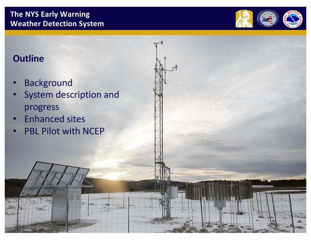
Outline
• Background• Systemdescriptionand
progress• Enhancedsites• PBLPilotwithNCEP

TheNYS EarlyWarningWeatherDetectionSystem
2016ICAP WORKINGGROUPMEETING,NCWCPTheNYSMESONET3
• ScarcityofweatherobservationsinNY• Long-termtrendsofheavierrainfall• Recenthistoryofveryexpensivehigh-impactevents• Stateeconomyisespeciallysensitivetoweather• Valuableforemergencymanagement,utilities,ground
transportation(roads,rail),aviation,agriculture,etc.
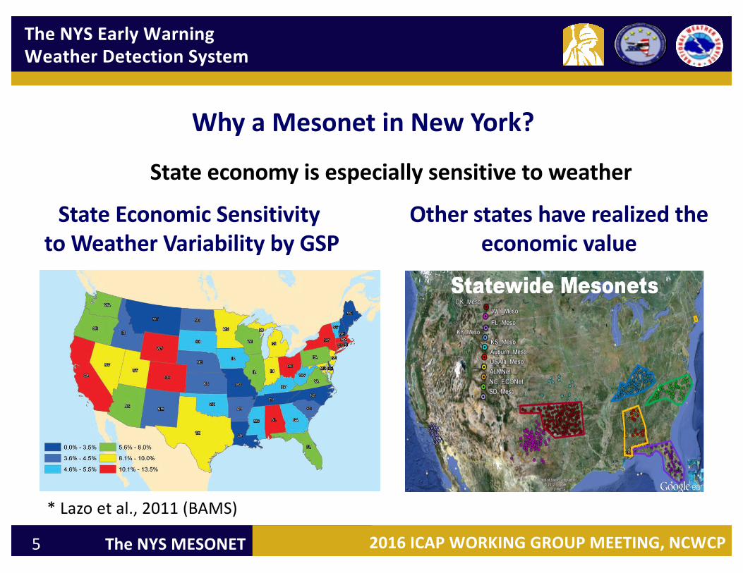
WhyaMesonetinNewYork?

TheNYS EarlyWarningWeatherDetectionSystem
2016ICAP WORKINGGROUPMEETING,NCWCPTheNYSMESONET4
27AutomatedSurfaceObservingStations(ASOS)
WhyaMesonetinNewYork?
SomeGapsinRadarCoverage
NWS&EmergencyManagersareoftenBlind
ScarcityofweatherobservationsinNY
TheNYS EarlyWarningWeatherDetectionSystem
2016ICAP WORKINGGROUPMEETING,NCWCPTheNYSMESONET5
WhyaMesonetinNewYork?
StateEconomicSensitivitytoWeatherVariabilitybyGSP
Otherstateshaverealizedtheeconomicvalue
*Lazo etal.,2011(BAMS)
Stateeconomyisespeciallysensitivetoweather

TheNYS EarlyWarningWeatherDetectionSystem
2016ICAP WORKINGGROUPMEETING,NCWCPTheNYSMESONET6
BriefOverview
• Comprisedof125stations,including:– Soilmoisture/temperatureat3depths– Camera(stillimages)– 20snowsites– 17profiler(“enhanced”)sites– 17fluxsites
• NYSMesonet awarded1April2014
• Datacollected,quality-controlled,anddisseminatedevery5min
• Have50+sitesnowoperational
• All125sitesoperationalby31December2016

TheNYS EarlyWarningWeatherDetectionSystem
2016ICAP WORKINGGROUPMEETING,NCWCPTheNYSMESONET7
TheNYS EarlyWarningWeatherDetectionSystem
• 125Sites
• Spaced~19milesapart
• Reportsevery5minutes
125StandardSites20SnowSites17EnhancedSites

TheNYS EarlyWarningWeatherDetectionSystem
2016ICAP WORKINGGROUPMEETING,NCWCPTheNYSMESONET8
SomeSiteSelectionConsiderations
• WMOstandards:– Generallyflatterrain– Noobstructions(notrees,pavement)within300ft
• Generalnetworkconfigurationwith19milespacing• Arearepresentativeness– valley,highterrain,crops,forests
• NWSinput– areaspronetoflooding;gapsinobservations
• FEMAguidelines:– Nofloodzones,nowetlands– Nohistoricalproperty– Noarchaeologicallysensitiveareas
• Requirea33’x33’area

TheNYS EarlyWarningWeatherDetectionSystem
2016ICAP WORKINGGROUPMEETING,NCWCPTheNYSMESONET9
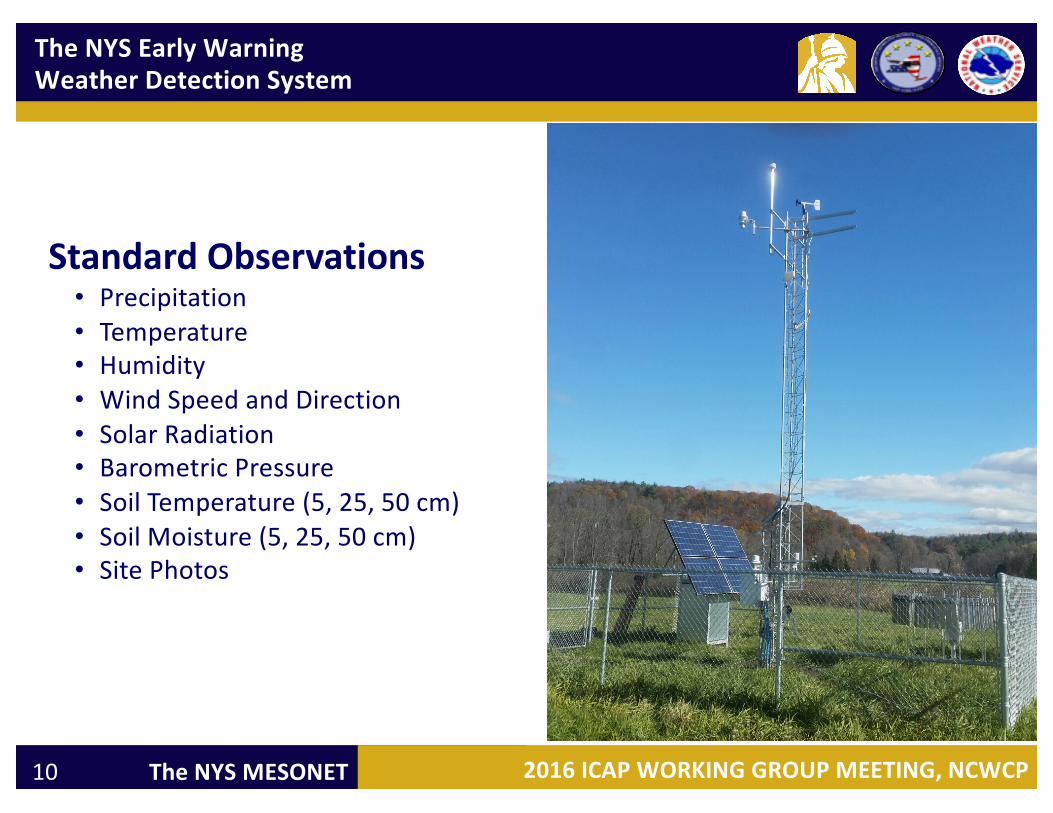
StandardObservations• Precipitation• Temperature• Humidity• WindSpeedandDirection• SolarRadiation• BarometricPressure• SoilTemperature(5,25,50cm)• SoilMoisture(5,25,50cm)• SitePhotos
StandardSite
TheNYS EarlyWarningWeatherDetectionSystem
2016ICAP WORKINGGROUPMEETING,NCWCPTheNYSMESONET10
StandardObservations• Precipitation• Temperature• Humidity• WindSpeedandDirection• SolarRadiation• BarometricPressure• SoilTemperature(5,25,50cm)• SoilMoisture(5,25,50cm)• SitePhotos
TheNYS EarlyWarningWeatherDetectionSystem
2016ICAP WORKINGGROUPMEETING,NCWCPTheNYSMESONET11
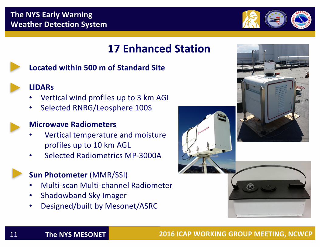
LIDARs• Verticalwindprofilesupto3kmAGL• SelectedRNRG/Leosphere 100S
MicrowaveRadiometers• Verticaltemperatureandmoisture
profilesupto10kmAGL• SelectedRadiometrics MP-3000A
SunPhotometer(MMR/SSI)• Multi-scanMulti-channelRadiometer• Shadowband SkyImager• Designed/builtbyMesonet/ASRC
17EnhancedStationLocatedwithin500mofStandardSite

TheNYS EarlyWarningWeatherDetectionSystem
2016ICAP WORKINGGROUPMEETING,NCWCPTheNYSMESONET12
OutputfromEnhanced/Standarddata:§ Clearsky/cloudclassification--- skycondition§ Accurateradiation(spectral,direct/diffuse)§ Profiles:Temp.,RH,Wind,andaerosols§ PBLheight,cloudbaseheight,LCL§ Aerosols:AOD&profile,SSA,AngstromCoefficient§ Clouds:cloudfraction,COD,Effectiveradius§ Forecastindices(CAPE,k,etc)
Complexprocess:§ Characterizemeasurement,retrievaluncertainties§ Developrobustretrievalalgorithms§ Productsdevelopedfromsynergisticretrieval/analysisapproach(multiplesensors)
EnhancedStation

TheNYS EarlyWarningWeatherDetectionSystem
2016ICAP WORKINGGROUPMEETING,NCWCPTheNYSMESONET13
Enhanced(Profiler) Sites

TheNYS EarlyWarningWeatherDetectionSystem
2016ICAP WORKINGGROUPMEETING,NCWCPTheNYSMESONET14
Wareetal2014
Profilerdataofatmospherictemperatureandstability
WeatherballoonderivedCAPEvaluefrom12ZonJune29thevolvedfromnearzeroto3,000J/kginjustacoupleofhoursdemonstratingtheadvantageofcontinuousprofiling
Novakovskaia etal2013
TheNYS EarlyWarningWeatherDetectionSystem
2016ICAP WORKINGGROUPMEETING,NCWCPTheNYSMESONET15
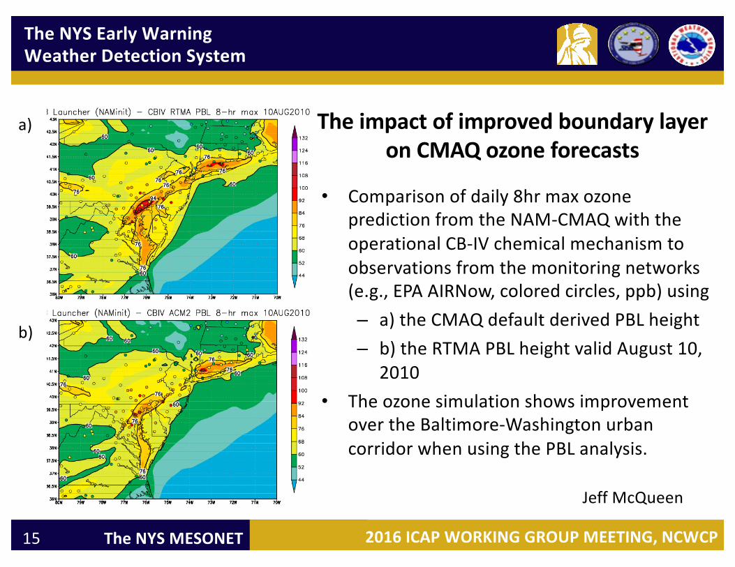
TheimpactofimprovedboundarylayeronCMAQozoneforecasts
• Comparisonofdaily8hrmaxozonepredictionfromtheNAM-CMAQwiththeoperationalCB-IVchemicalmechanismtoobservationsfromthemonitoringnetworks(e.g.,EPAAIRNow,coloredcircles,ppb)using– a)theCMAQdefaultderivedPBLheight– b)theRTMAPBLheightvalidAugust10,
2010• Theozonesimulationshowsimprovement
overtheBaltimore-WashingtonurbancorridorwhenusingthePBLanalysis.
a)
b)
JeffMcQueen
TheNYS EarlyWarningWeatherDetectionSystem
2016ICAP WORKINGGROUPMEETING,NCWCPTheNYSMESONET16
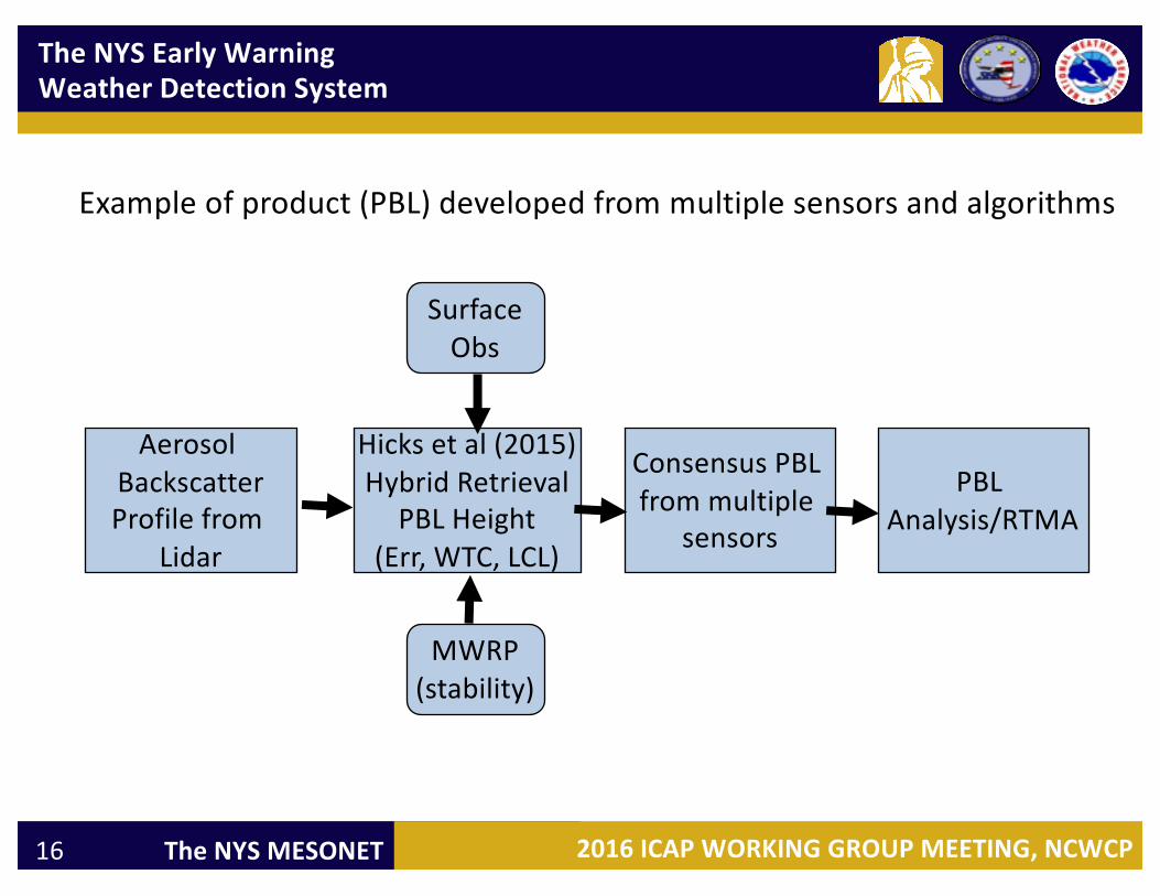
AerosolBackscatterProfilefrom
Lidar
Hicksetal(2015)HybridRetrieval
PBLHeight(Err,WTC,LCL)
ConsensusPBLfrommultiple
sensors
PBLAnalysis/RTMA
Exampleofproduct(PBL)developedfrommultiplesensorsandalgorithms
MWRP(stability)
SurfaceObs

TheNYS EarlyWarningWeatherDetectionSystem
2016ICAP WORKINGGROUPMEETING,NCWCPTheNYSMESONET17
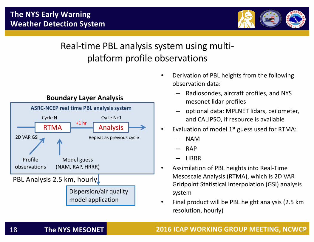
DevelopingunifiedPBLanalysissystem-- ASRCforNYSandNCEPCONUS
LeverageprototypePBLanalysisestablishedbyNOAA-NASA-HowardROSESprojectin2007(McQueen)
Objectives:• DevelopnearrealtimePBLproductsbyblendingmodelestimatesandmulti-
platformprofileobservations(aircrafts,radiosonde,andNYSmesonet).• DemonstrateuseofNYSmesonet verticalprofilesforreal-timePBLanalysis.• DemonstratetheimpactofPBLanalysisonairquality/dispersionmodeling.
UAlbany/ASRC-NCEPCollaborationonReal-Time PBLAnalysisStudy
TheNYS EarlyWarningWeatherDetectionSystem
2016ICAP WORKINGGROUPMEETING,NCWCPTheNYSMESONET18
Real-timePBLanalysissystemusingmulti-platformprofileobservations
• DerivationofPBLheightsfromthefollowingobservationdata:– Radiosondes,aircraftprofiles,andNYS
mesonet lidar profiles– optionaldata:MPLNETlidars,ceilometer,
andCALIPSO,ifresourceisavailable• Evaluationofmodel1st guessusedforRTMA:
– NAM– RAP– HRRR
• AssimilationofPBLheightsintoReal-TimeMesoscaleAnalysis(RTMA),whichis2DVARGridpoint StatisticalInterpolation(GSI)analysissystem
• FinalproductwillbePBLheightanalysis(2.5kmresolution,hourly)
RTMA Analysis
Profileobservations
Modelguess(NAM,RAP,HRRR)
Dispersion/airqualitymodelapplication
+1hr
Repeataspreviouscycle
CycleN CycleN+1
ASRC-NCEPrealtimePBLanalysissystem
BoundaryLayerAnalysis
18
2DVARGSI
PBLAnalysis2.5km,hourly

TheNYS EarlyWarningWeatherDetectionSystem
2016ICAP WORKINGGROUPMEETING,NCWCPTheNYSMESONET19
PBLheightsfromNAMmodelandaircraftobservations
TheNYS EarlyWarningWeatherDetectionSystem
2016ICAP WORKINGGROUPMEETING,NCWCPTheNYSMESONET20
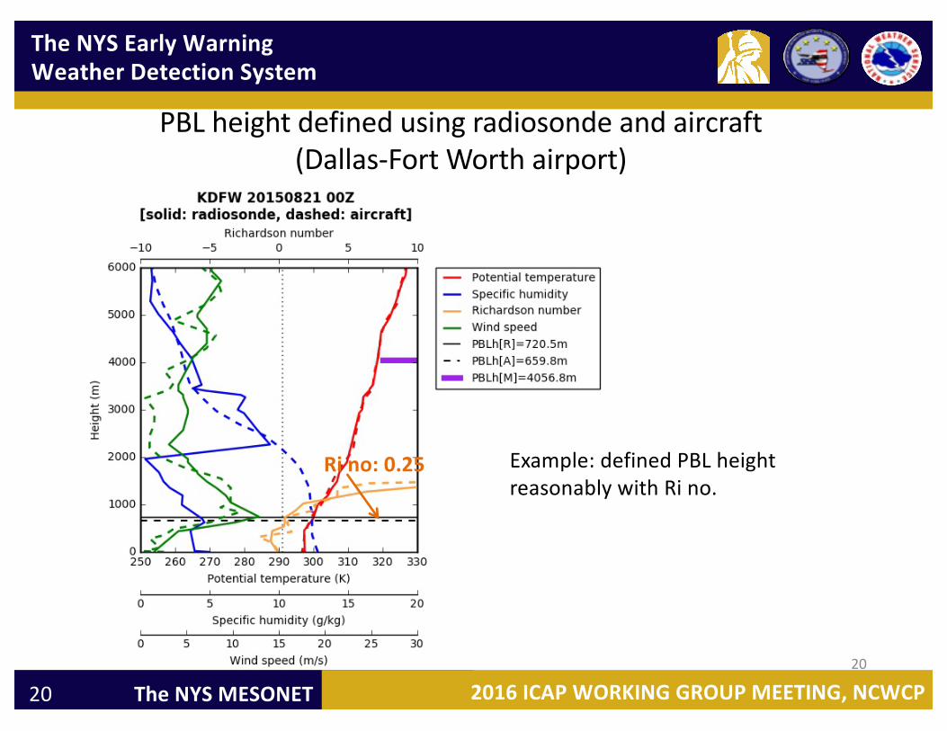
PBLheightdefinedusingradiosondeandaircraft(Dallas-FortWorthairport)
20
Example:definedPBLheightreasonablywithRi no.
Ri no:0.25

TheNYS EarlyWarningWeatherDetectionSystem
2016ICAP WORKINGGROUPMEETING,NCWCPTheNYSMESONET21
QUESTIONS,THOUGHTS,COMMENTS
JerryBrotzge,[email protected]
ChrisThorncroft,PhDChair,UAlbany [email protected]
Everette Joseph,PhDDirector,UAlbany [email protected]