Embed Size (px)
Citation preview
APPENDIX D
REAL ESTATE PLAN


APPENDIX D REAL ESTATE PLAN
TABLE OF CONTENTS
1. STATEMENT OF PURPOSE 2. REFERENCES 3. AUTHORIZATION 4. BACKGROUND 5. LOCATION 6. REAL ESTATE REQUIREMENTS 7. OWNERSHIP OF REAL PROPERTIES NEEDED
FOR THIS PROJECT 8. ESTATE REQUIRED 9. MAPPING 10. NAVIGATIONAL SERVITUDE 11. RELOCATIONS 12. FLOODING INDUCED BY PROJECT CONSTRUCTION 13 FUTURE MINERAL ACTIVITIES AND TIMBER ACTIVITIES 14 FEDERALLY OWNED LANDS 15 PUBLIC LAW 91-646 16 ZONING ENACTMENTS 17 PUBLIC FACILITY RELOCATIONS 18 NEPA, NHPA & HTRW 19 REAL ESTATE COST ESTIMATE 20 ASSESSMENT OF NON-FEDERAL SPONSOR

TABLE OF CONTENTS (cont’d)
21 PROJECT SCHEDULE
22 RECOMMENDATIONS
EXHIBITS PROJECT LOCATION “A” PROJECT REACHES “B” BEACH ACCESS POINTS “C” STATE AND LOCAL PLACEMENT AREA “D” OWNERSHIP INFORMATION “E”
CHART OF ACCOUNTS “F” ASSESSMENT OF LOCAL SPONSOR CHECKLIST “G”

APPENDIX D
REAL ESTATE PLAN
1.0 STATEMENT OF PURPOSE This Real Estate section is tentative in nature, and it is for planning purposes only. The figures in this report are subject to changes once: (a) the project scope is defined; (b) concrete parameters are set; (c) maps are drawn showing the exact locations; (d) the exact number of acres needed for mitigation, environmental restoration, and utility relocation are identified; (e) realistic values are established as to the cost of the property to be acquired; and (f) a determination is made as to the exact number of easements needed. This Real Estate Plan supports the Coastal Storm Damage Reduction Project for Willoughby Spit and Vicinity located in the city of Norfolk, Virginia. 2.0 REFERENCES
a. ATR Draft Main Report – Willoughby Spit Coastal Storm Damage Reduction Project b. Project Delivery Team (PDT) Meetings.
3.0 AUTHORIZATION This study is authorized by resolution adopted 15 Sepetember1971, by the Committee on Public Works of the Senate, which reads:
"That in accordance with Section 110 of the River and Harbor Act of 1962, the Secretary of the Army, be, and hereby requested to cause to be made under the direction of the Chief of Engineers, a survey of the shores of Willoughby Spit in the City of Norfolk, Virginia, and such adjacent shores as may be necessary, in the interest of beach erosion control and hurricane protection and other related matters. "
The Water Resources Development Act (WRDA) of 1986, as amended, authorized the recommendations in the 1983 Feasibility Report as a Federal project.
The September 2004 Reconnaissance Level Report was accomplished in response to Congressional direction and the inclusion of funds for continued planning, in light of the damage done to the area by Hurricane Isabel in September 2003. This General Reevaluation Report (GRR) was accomplished in response to Memorandum, CENAD-PSD, dated 18 February 2005, subject: Willoughby Spit and Vicinity, Norfolk, VA, Reconnaissance Level Report, which approved the 2004 report and granted authority to proceed to a GRR subject to the availability of funds.

Congress added funds and corresponding language in Fiscal Year 2004, which directed the Corps of Engineers to conduct a reconnaissance like study to determine if the authorized project continued to meet the current needs of the city of Norfolk, was still economically feasible, and in the Federal interest to construct. That report, which was completed in September 2004, determined that the authorized project or a reformulated project would be in the Federal interest and recommended the conduct of the General Reevaluation Study. 4.0 BACKGROUND
This study examines the feasibility of coastal storm damage reduction for the 7.3 miles of Chesapeake Bay shoreline within the city of Norfolk. The location and orientation of this shoreline along southern Chesapeake Bay, and immediately within the mouth of the bay, have made the entire study area readily susceptible to damage associated with coastal storms such as hurricanes and northeasters. Storm tides, high winds, and wave action have impinged on developed areas resulting in loss of land, property damage, and endangered health and safety. The August 1933 hurricane and the March 1962 northeaster caused significant damage to the beach front areas. More recent storms to impact the area include Hurricane Isabel in 2003 and the November 2009 Nor’easter. Specifically, this study is a reanalysis of the findings of the 1983 Feasibility Report, the recommendations of which were authorized as a Federal project in the WRDA of 1986, as amended. This reanalysis uses current planning criteria, policies and conditions and the results of this study can affirm the previously authorized project; reformulate and or modify it as appropriate; or conclude that no plan is currently justified. In order to facilitate the engineering and economic analyses conducted during the course of this study, the 7.3 miles of study area shoreline have been divided into three individual segments. These segments include the 10,030-foot East Ocean View Segment which encompasses East Beach and vicinity and the East Ocean View Area communities; the 16,370-foot Central and Western Ocean View segment which encompasses the Cottage Line Area and the Central Ocean View Area communities; as well as the 11,770-foot Willoughby Spit segment which encompasses the Willoughby Spit community. Each segment is shown separately on Exhibit B, C, and D. 5.0 LOCATION The study area is located in southeastern Virginia within the city of Norfolk (See Exhibit A). It is about 100 highway miles southeast of Richmond, the state capital, and 200 highway miles southeast of Washington, D.C. The 66-square mile community is the business, financial, cultural, educational, and medical center of the Hampton Roads region. It is part of the Norfolk-Virginia Beach-Newport News Metropolitan Statistical Area in southeastern Virginia. About 7.3 miles of shoreline are on the southern shore of the Chesapeake Bay. The immediate study area includes 7.3 miles of shoreline along the southern shore of the Chesapeake Bay extending from the tip of Willoughby Spit to the entrance of Little Creek Inlet. The location and orientation of the study area shoreline at the southern

boundary of the Chesapeake Bay and immediately within the mouth of the bay have made this area highly susceptible to damages associated with a coastal storm activity. Land use in this area is predominantly residential with commercial and public use interspersed. Both ends of the shoreline are bordered by Federal military reservations. On the south side of Willoughby Bay and just inside the entrance to Hampton Roads is the Naval Base Norfolk. The Amphibious Base Little Creek is located at the other end of the shoreline, just east of Little Creek Inlet. Three public beaches, Ocean View Beach Park, Sarah Constant Shrine Beach, and Community Beach are located along the shoreline. These parks account for about 9 acres of open space each contain parking, life guards, restrooms and shower facilities.
While the 7.3 miles shoreline of the immediate study area is a continuous beach, it has been divided into three individual segments to facilitate engineering and economic analyses. These segments include the 10,030-foot East Ocean View segment, the 16,370-foot Central and Western Ocean View segment, and the Willoughby Spit segment (see Exhibit B). 6.0 REAL ESTATE REQUIREMENTS
There were various types of shore protection alternatives considered for implementation along the study area shoreline to reduce the damages from coastal storms. Structural measures included such features as beachfill with and without enhanced dunes, seawalls, bulkheads, revetment, groins, and breakwaters. Non-structural measures included flood plain regulations, permanent relocation/evacuation, flood proofing, storm warning and temporary evacuation, and flood insurance program. The "no action" alternative was carried forward as a basis for comparison for any plan of improvement and implies acceptance of the existing coastal storm problems. The formulation process concluded that beachfill was the most appropriate means of addressing the coastal storm damage problems of the study area, as described below:
Proposed Beachfill Project
Beachfill is the physical increase in beach width and/or height by the placement of a suitable quality and quantity of sand on the beach at proper intervals of time. This measure involves the placement of sand from offshore borrows sources directly onto the beach in order to widen and stabilize the existing berm profile by 60 feet at an elevation of 3.5 feet above the North American Vertical Datum (NAVD) of 1988. Usually, the sand is pumped from an offshore borrow site onto the beach using a dredge and pipeline. An appropriate design uses borrow material that has similar properties to the existing beach sand. The beach is initially built to the specifications of a construction berm/profile that will be reshaped by the area's coastal dynamics and reach a quasi-equilibrium state. Sufficient material is used in the beach construction to provide advance nourishment so that the berm/profile will never be less than the design criteria established to provide the desired level of storm protection. The beach requires renourishment on a periodic basis so that the design berm width and elevation are maintained. The construction will take place both from water and land access points. Land access will be gained using existing public and private streets that lead up to the

public owned beach (see Exhibit C). The staging and construction will take place on existing public city owned beaches or easement areas and state owned bottom. Construction Right of Entries will be obtained from the city for beach construction. A Virginia Marine Resources Commission Permit will be obtained for the work on the state owned bottom. Access rights of entries will be acquired for the use of both the public streets that lead to the beach, as shown. 7.0 OWNERSHIP OF REAL PROPERTIES NEEDED FOR THIS PROJECT Exhibit D shows the approximate state and local project placement areas. The city of Norfolk either owns or has easement interest in the upland areas to receive the beachfill material. They also own the public streets to be used for access and staging purposes. The Commonwealth of Virginia owns the river bottom to be filled. In 1962, the VMRC began a permit program designed to regulate encroachments in, on, under or over the state-owned submerged lands. The authority for this permit program, established by the General Assembly, now requires that when determining to grant or deny any permit the VMRC shall be guided in its deliberations by the provisions of Article XI, Section 1 of the Constitution of Virginia and the VMRC shall exercise its authority consistent with the Public Trust Doctrine. The VMRC shall also consider effects on other reasonable and permissible uses of state waters and state-owned bottomlands, marine and fisheries resources of the Commonwealth, tidal wetlands, adjacent and nearby properties, water quality and submerged aquatic vegetation. The environmental permits issued by the Habitat Management Division of the VMRC are of three types; subaqueous or bottomlands, tidal wetlands, and coastal primary sand dunes. The division's authority and responsibilities emanate from Subtitle III of Title 28.2 of the Code of Virginia and specifically regulates physical encroachment into these areas. The permit process relies on a single Virginia joint local/state/federal permit application. The review processes, for which this application was originally designed, takes into account various local state, and Federal statutes governing the disturbance or alteration of environmental resources. The VMRC plays a central role as an information clearinghouse for all three levels of review. Applications receive independent yet concurrent review by local wetland boards, the VMRC, the Virginia Department of Environmental Quality, and the U.S. Army Corps of Engineers. A listing of public and private property owners in the vicinity of the project is shown in Exhibit E. 8.0 ESTATE REQUIRED The project requires a construction, monitoring, and renourishment every 9 years to make sure it is successful. An “AUTHORZATION FOR ENTRY FOR CONSTRUCTION” will be utilized per ER 405-1-12, Chapter 12, Appendix 12-F (Change 31, May 1998). This standard estate is shown below:

AUTHORIZATION FOR ENTRY FOR CONSTRUCTION
I, (name of accountable official), (title) for city of Norfolk, do hereby certify that
the city of Norfolk has acquired the real property interests required by the Department of the Army, and otherwise is vested with sufficient title and interest in lands, to support construction of (project name, specifically identified project features, etc.). Further, I hereby authorize the Department of the Army, its agents, employees and contractors, to enter upon (identify tracts) to construct (Project name, specifically identified project features, etc.) as set forth in the plans and specifications held in the U.S. Army Corps of Engineers’ Norfolk District Office, Norfolk, Virginia. In the Commonwealth of Virginia, the right to do work on state owned public river bottom is included in the joint regulatory permit review process, and no additional real property interest will be required. There are no existing Federal projects or federally owned lands located within this project area that can be used for this project. 9.0 MAPPING
Mapping is included in Exhibits A through D. Exhibit A shows the project location; Exhibit B shows the three project reaches; Exhibit C shows the beach access points; and Exhibit D shows the State and local placement areas. 10.0 NAVIGATIONAL SERVITUDE Navigational Servitude is not applicable. 11.0 RELOCATIONS No utility relocations or are required for the construction of this project. No assistance benefits relocations are anticipated under PL 91-646 for this project.
12.0 FLOODING INDUCED BY PROJECT CONSTRUCTION Not applicable. This project will not increase storm-related flooding. 13.0 FUTURE MINERAL ACTIVITIES AND TIMBER ACTIVITIES No future mineral activities or other subsurface minerals or timber activities are involved in this project. 14.0 FEDERALLY OWNED LANDS There are no existing Federal projects or federally owned lands located within this project area that can be used for this project. 15.0 PUBLIC LAW 91-646 There are no person, farms or businesses that will be relocated, therefore, Public Law 91-646, is not applicable.

16.0 ZONING ENACTMENTS There are no zoning enactments that are needed for this project. There are no zoning ordinance changes proposed in lieu of, or to facilitate, acquisition in connection with this project.
17.0 PUBLIC FACILITY RELOCATIONS
No utility relocations are required for the construction of this project. 18.0 NEPA, NHPA & HTRW
The environmental report prepared for this project indicted there are no hazardous, toxic or radioactive waste known to exist on the real property needed for this project. 19.0 REAL ESTATE COST ESTIMATE The estimated real estate costs for this project include the real estate administrative expenses of $35,000, and a gross appraisal and review of about $10,000 (see Exhibit F). There are expected to be LERRD credits to the city of Norfolk, but an estimate cannot be made until updated ownership GIS data is provided by the city. These credits will be for the easements for the beach work and the road access. 20.0 ASSESSMENT OF NON-FEDERAL SPONSOR The local sponsor is the city of Norfolk. The Norfolk District Corps of Engineers has worked with the city on several Local Cooperation Projects within the city limits. The city has demonstrated the ability and the resources necessary to acquire the real estate interest required to construct and maintain the projects as required for local cooperation. A local sponsor checklist is included as Exhibit G. The need for use of “quick take” authority is not anticipated for this project. 21.0 PROJECT SCHEDULE
REAL ESTATE ACQUISITION SCHEDULE
Item Date PPA Signed No Date Set
Send Notice to Proceed with Acquisition 3 days after receipt of Signed PPA
Acquisition Completed 12 months from date of notice to proceed
Certification by Chief of Real Estate 3 days after notice of completion of acquisitions from local sponsor
Project Put Out For Bids Upon certification by the Chief of Real Estate
The need for and timing of rights of entry and construction staging areas have been discussed with the sponsor and there is general agreement that sufficient time is available to accomplish the activities outlined in the above table. Written sponsor concurrence in the schedule is being coordinated. 22.0 RECOMMENDATION This report has been prepared in accordance with Corps of Engineers Regulation 405-1-12, Chapter 12 (Draft). It is recommended that this report be approved. Prepared by: ________________________ Lanny M. Pricer Realty Specialist Reviewed by: ________________________ David B. Parson Chief, Acquisitions Management and Disposal Section


Exhibit A

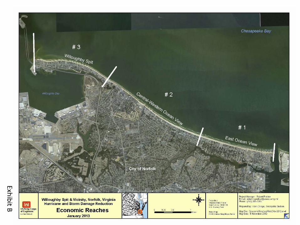
Exhibit B


Exhibit C


Exhibit D


EXHIBIT F

EXHIBIT G

EXHIBIT G