Embed Size (px)
Citation preview

Reactivated ancient slides at the Sungai Kelalong Dam site,Bintulu Sarawak, East Malaysia
TAJUL ANUAR JAMALUDDIN
Geology Department, University of Malaya50603 Kuala Lumpur, Malaysia
Abstract: The Sungai Kelalong Dam site is founded in the interbedded mudstone-sandstone of the Miocene age Nyalau Formation.The formation has been mildly deformed and resulted in very broad, open syncline-anticlinal folds plunging in the South to Southwestdirection. The rock masses are dissected by at least 4 sets of discontinuities, mainly the bedding planes, joints and faults. The occurrenceof massive landslide on the spillway slope and part of the neighbouring core trench wall was largely attributed to the intersection of lowangle, listric normal fault and the subvertical, E-W striking fault zone. The former is interpreted as a sliding plane of an ancient slide,which probably took place during the Pliocene uplifting in a condition of wet soft sedimentary deformation, to allow for the formationof well-developed normal listric faults system. Reactivation of the ancient slide is caused by the extensive earthworks activities for thedam construction which resulted in massive landslide to the spillway slope. This case study gives clear examples of the importance ofgeological inspection during the construction stage to check and to detect any structural defects that were not identified in the previoussite investigation works.
Abstrak: Tapak pendasaran Empangan Sungai Kelalong, Bintulu, Sarawak terdiri daripada selang lapis batu lumpur dan batu pasirFormasi Nyalau yang berusia Miosen. Batuan Formasi Nyalau ini tercangga lemah dan terlipat dalam bentuk sinklin-antiklin yangsangat landai dan paksinya menjunam dalam arah Selatan – Barat Daya. Ketakselanjaran pada jasad batuan di kawasan ini dibentuk olehsatah-satah perlapisan, kekar, sesar dan zon sesar. Kejadian tanah runtuh di bahagian cerun alur limpah dan sebahagian daripada paritteras empangan dipercayai berpunca daripada persilangan di antara sesar normal listrik bersudut-landai dengan zon sesar curam yangberjurus hampir T-B. Satah sesar listrik itu dipercayai merupakan satah gelinciran kepada sebuah gelinciran kuno yang dipercayaiterbentuk semasa Pliosen dalam keadaan canggaan ketika sedimen masih basah dan lembut, yang mana membolehkan terbentuknyasuatu sistem sesar normal listrik yang baik. Pengaktifan semula gelinciran kuno ini disebabkan oleh aktiviti-aktiviti kerjatanah semasapembinaan pendasaran alur limpah dan empangan utama. Kajian kes yang dipersembahkan ini jelas menggambarkan betapa pentingnyakerja-kerja penyiasatan geologi semasa pembinaan untuk menentusahkan kehadiran sebarang unsur-unsur kecelaan geologi yang tidakdapat dikenalpasti semasa penyiasatan tapak sebelum pembinaan.
INTRODUCTIONSungai Kelalong Dam is located approximately 20
km northeast of Bintulu, Sarawak and forms part of theBintulu Water Supply Stage III project. The main streamis locally named as Sg. Kelalong, tributary of the SungaiSibiu. The main stream is a 10 m wide shallow stream thatflows west before turning abruptly south to eventuallyjoin Sungai Sibiu. The dam site is located at about 600 msouth of the above mentioned abrupt turn in flow direction(Figure 1). Access to the proposed dam site itself is byway of an upgraded logging track which branches offfrom Km 18, Rumah Mujah, Bintulu – Miri trunk road.The construction of the dam began in early 2002 and it isexpected to be completed in mid 2004.
This paper presents a classical example of anoccurrence and field recognition of an ancient slide(probably submarine) which was reactivated by currentengineering activities. Reactivation of the ancient slideresulted in a massive slope failure (landslide) to thefoundation site of the proposed spillway and part of themain dam. The presence of the ancient slide was detectedduring geological mapping which was specially arrangedin June 2002. The original intention of the mapping wasto investigate the caustive factor for the major landslidewhich occurred at the spillway foundation and the coretrench wall of the main dam between CH650 and CH730.
Having done detailed mapping, it was found that thelandslide was primarily due to the presence of the ancientslide, in which its basal fault plane intersected withanother subvertical major fault striking almost E-W. Thiscase study is an example where detailed geologicalmapping is very important to extract vital geotechnicalinformation, which could not be identified from subsurfaceinvestigation (boreholes).
In this study, the strength and consistency of the rocksand soils were estimated based on guidelines by the ISRMsuggested methods (Brown, 1981). The weathering gradesof the rock masses were described based on the IAEGclassification scheme which was refined by Attewell(1993).
GEOLOGY OF THE BINTULU AREAThe regional geology of the Bintulu area, as a whole,
is well documented in Khoo (1968) and the stratigraphyis summarised in Table 1. The oldest rocks, known as theBiban Sandstone Member of the Nyalau Formation, areof Lower Miocene age, and consist of hard sandstone withsubordinate shale and some limestone. The rest of theoverlying Nyalau Formation is of Miocene age, about3,000 m thick, and consists of mudstone and sandstonewith coal seams and some limestone. These sedimentswere deposited under shallow-water marine conditions,
Annual Geological Conference 2004, June 4 – 6Putra Palace, Kangar, Perlis, Malaysia
Geological Society of Malaysia, Bulletin 49, April 2006, p. 5-11

REACTIVATED ANCIENT SLIDES AT THE SUNGAI KELALONG DAM SITE, BINTULU SARAWAK, EAST MALAYSIA
Geological Society of Malaysia, Bulletin 496
Table 1: Stratigraphy of the Bintulu area (after Khoo, 1968).
but the occurrence of coal seams suggest that coastalswamps or deltaic conditions also developed locally attimes.
The Nyalau Formation is overlain conformably by,and probably in part interdigitates with the Setap ShaleFormation. The Setap Shale is also of Miocene age (Te
1-4
to Te5).
The rocks have been affected by slight to moderatefolding, accompanied by faulting, which took placeprobably in Late Pliocene times. The major folds axestrend E-NE and the folds are mainly in the form of verygentle open synclines-anticlines.
The Pliocene folding was followed by uplift whichraised most of the area above sea level in Late Pliocenetimes, and prolonged erosion reduced much of the area toa peneplain. Subsequent uplift and further erosion,probably in the Early Pleistocene, caused further erosionand dissection of the peneplain. The rise of sea level inthe order of 40-60 m, resulted in the formation of marineand fluvial terraces. Successive eustatic sea level changesin the late Pleistocene caused the lower terraces to bebuilt, now at about 3-7 m above sea level. In recent times,sand silt and clay were deposited in river valley andcoastal regions, and extensive peat swamps have formed.
The drainage pattern of the Bintulu and surroundingareas is characterized by subdendritic to sub-trellispatterns, which suggests structural control, notably bythe bedding plane orientation as well as fold culminations.Negative lineaments occur mainly in NNE-SSW, NW-SEand some E-W directions.
SITE GEOLOGYThe general geology of the site is given in detail in
Tajul Anuar Jamaluddin (2003). In general, the site consistsof sedimentary rocks of the Nyalau Formation, of Mioceneage. The formation consists predominantly of mudstonesinterbedded with thin fine to medium-grained sandstonesand siltstone.
Lithology
MudstonesThe mudstones are mainly bluish grey, grey to dark
grey in colour. They occur mostly as beds from 1 cm to 1.5m and are typically grey to dark grey and generallyweathered to pale grey, bluish grey, grey brown or buff. Inmost of the outcrops, the mudstones are interbedded withlight-coloured sandy shale and grey fine-grainedsandstone. In places the mudstone layers contain beds ofhard bluish grey, fine-medium grained sandstone from 2-10 cm thick.
Carbonaceous materials and plant remains arecommon, occurring either as finely disseminated flecksthroughout the mudstone or as thin laminae along beddingplanes. Bioturbation structures are abundant in some beds,occurring either as subvertical, inclined burrows orgrazing tracks on the bedding planes.
The geology at the site is dominated by mudstonesand mudstone-dominated sequences. Their occurrence canbe easily recognised by their distinct dark-coloured clayeysoils, once the overlying residual soils are stripped off theground.Sandstones
The sandstone generally occurs as beds from severalcm to 0.5 m thick, interbedded with shale and siltstone orsandy shale. The sandstone is soft to moderately hard,grey to bluish grey, greyish white and fine to medium-grained sandstone.
In the lower part of the formation, the sandstone bedsare often thicker and reach up to 1.5 m thick, massivesandstone. However in the upper part of the formation, thesandstone beds tend to be thinner in the order of several totens of centimeters, where the proportion of mudstone ismuch more than the sandstone. Cross bedding and crosslamination are common in some sandstone beds, notablyat the Diversion Culvert excavation area. A few beds showslump bedding and ripple marks.
The sandstones are lithic sandstone, and accordingto Khoo (1968), most of them fall in the quartzosesubgreywacke class, containing between 10-25% unstable
Figure 1. Map showing the geographic location of the SungaiKelalong Dam site, Bintulu Sarawak.
TAJUL ANUAR JAMALUDDIN
April 2006 7
Table 2 : Summary of the discontinuity data from the Sg. KelalongDam site.
constituents (rock fragments and feldspars). The typicalsandstone is a fine-grained, moderately sorted rock,consisting essentially of subangular to sub-rounded grainsmostly between 0.15 and 0.25 mm across. Fine-grainedcarbonaceous material is common on bedding planes insome laminated sandstone, and sometimes shale flakesare lying subparallel to the bedding plane.
Structures and discontinuitiesThe rocks in the dam site have been slightly deformed
into a series of very gentle, open, syncline-anticline foldswhose axes are plunging very gentle towards south tosouth-southwest. The bedding planes are generally verygently dipping (5° -10°) to the SSW, SW and WSW (Table2).
The dam site is cut by a number of NE-SW and NW-SE trending lineaments which can be inferred as majorjoints or fractures. The rock mass along these lineamentsare generally highly sheared and the weathering profilesuddenly thicker than the less dissected counterparts.
In addition to the bedding planes (B), the rocks in thestudy area are also affected by at least 3 major sets ofjoints, i.e. J1, J2 and J3. Set J1 and J2 have a steep diptowards ESE and NNE, respectively. While Set J3commonly has subvertical dip and strikes in ESE-WNWdirection. The other two sets of joints (J4 and J5) commonlyoccur as impersistent, tight, minor and locallised joints.Average orientations of these discontinuities aresummarised in Table 2.
WeatheringGrade VI materials or residual soils are generally about
1.5 to 2.5 m thick, and consist predominantly of soft tofirm, light yellowish brown to yellow, clayey to silty fineSAND and silty CLAY. The residual soil is typicallyyellowish-coloured and can be readily distinguished fromthe underlying dark-coloured grade V and grade IVmaterials by its colour contrast and relativelyhomogenous texture. Grade V materials or completelyweathered (CW) rocks, consist predominantly of firm tostiff grey, light reddish brown clayey SILT or loose tomedium dense reddish yellow and orange silty fine SAND.Reddish coloured soils of Grade V materials often containsome amount of iron-oxides or lateritic gravels.
Grade IV materials or Highly Weathered (HW) rocksoften consists of extremely weak to very weak rocks. Theprofile thickness varies between 4 and 6 m. The handspecimens can be crumbled with bare hands or brokenwith a single firm blow of geological hammer. These HWrocks are distinguished from the above by its rockyappearance, where original rock fabric and relict structuresare well preserved and clearly visible with the naked eye.
Grade III materials or moderately weathered (MW)rocks, are commonly encountered at about 8 – 9 m belowthe original ground level. In general, Grade III materialsare characteristically, weak to medium strong rock, cannot
be broken with bare hands and require firm blows ofgeologist hammer to break the sample. Grade II (slightlyweathered) rocks are only exposed in deep excavation,normally more than 7-9 m below the original ground level.Grade II rocks are generally medium strong to strong rocks.Grade I (Fresh or Unweathered) rocks were not exposed atthe dam site during the course of this study.
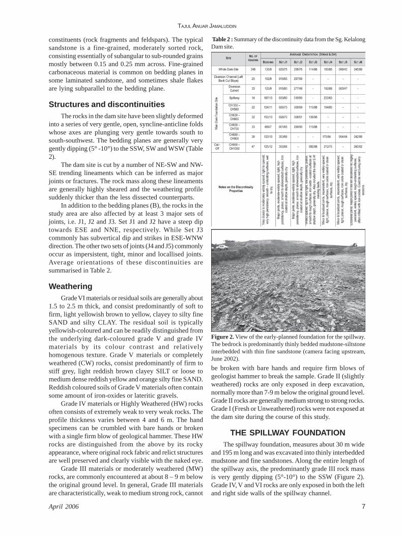
THE SPILLWAY FOUNDATIONThe spillway foundation, measures about 30 m wide
and 195 m long and was excavated into thinly interbeddedmudstone and fine sandstones. Along the entire length ofthe spillway axis, the predominantly grade III rock massis very gently dipping (5°-10°) to the SSW (Figure 2).Grade IV, V and VI rocks are only exposed in both the leftand right side walls of the spillway channel.
Figure 2. View of the early-planned foundation for the spillway.The bedrock is predominantly thinly bedded mudstone-siltstoneinterbedded with thin fine sandstone (camera facing upstream,June 2002).

REACTIVATED ANCIENT SLIDES AT THE SUNGAI KELALONG DAM SITE, BINTULU SARAWAK, EAST MALAYSIA
Geological Society of Malaysia, Bulletin 498
Figure 3. Bulging along the toe of the spillway slope – a clearevidence for slope movement.
Figure 7. Note the sharp and sudden contrast in the weatheringprofile which indicate the profound structural control by the majorfault zone referred to in Figure 6.
Figure 5. Side view of the same landslide which also badly affectedthe core trench wall of the main dam foundation.
THE SPILLWAY SLOPE FAILUREThe spillway slope failure took place at the end of
May 2002 in the form of massive landslides after a fewdays of prolonged rainfall. The failure affected almosttwo-third of the spillway slope (Figures 3 & 4) and alsobadly damaged part of the neighbouring core trench wallof the main dam (Figure 5). On the spillway side, thelandslide resulted in a marked toe bulging (Figure 3) andwidely open (up to 30 cm wide) tension cracks associatedwith measurable vertical drops (about 20-30 cm) that
Figure 6. Close-up plan view of the closely spaced, open and sub-parallel fractures within the E-W striking fault zone, along whichthe tension cracks and the rear sliding plane for the failure weredeveloped.
Figure 4. The failure scarp of the landslide on the spillway slope.
dissected the upper slope and spillway crest in an almostE-W direction (Figure 4). The tension cracks can be tracedfor more than 50 m in length along strike and was actuallydeveloped along a major fault zone striking almost E-W.The fault zone itself is characterised by a 20-25 m widebelt of subvertical open fractures (Figure 6) and shearedrocks, often filled up with reddish brown iron oxides andlateritic materials, running subparallel to each other in095-110° direction as seen on the floor of the right wingdam foundation between CH650-CH680. The fault zoneis also marked by a sudden change in the weathering gradeof the rock mass as seen in the nearby excavation wall(Figure 7). The rear scarp of the landslide and theassociated tension cracks were actually developed alongthis subvertical fault zone.
On the left of the spillway, the same landslide hasalso badly affected the core trench wall of the main damfoundation. The landslide looks more severe on the coretrench wall because the cut face is steeper (about 80°)than the spillway slope (about 22°). Viewed from core

TAJUL ANUAR JAMALUDDIN
April 2006 9
Figure 8. A major low-angle listric normal fault as exposed in the right wall of the Spillway excavation site. Insets show the close-upview of the individual fault plane.
Figure 9. An idealised sketch (not to scale) showing the interpretative geological section along the Spillway axis. The slope failure isattributed to the presence of a major, low angle listric normal fault (an old sliding plane) which intersecting with the subvertical E-W faultzone.
trench side (Figure 5), the failure scarp can be clearly seenbounded by the subvertical E-W fault zone describedabove.
CAUSATIVE FACTORS –REACTIVATED ANCIENT SLIDE
A special post-mortem fieldwork was conducted inearly June 2002, about a week after the failure took place,to investigate the causes for the landslide. Based on close
inspection, it was found that the site of the spillwayfoundation is located within a package of an ancient slide,which has been totally weathered into grade IV to gradeVI materials. This is evident by the presence of a major,low angle, basal sliding plane which resembles much of a“listric normal fault” system as shown by McClay & Ellis(1987) in their experimental analogue modellings.Thelistric normal fault plane is oriented subparallel to thebedding planes, and it was encountered just a few dmabove the spillway floor level (Figure 8).This basal fault,

REACTIVATED ANCIENT SLIDES AT THE SUNGAI KELALONG DAM SITE, BINTULU SARAWAK, EAST MALAYSIA
Geological Society of Malaysia, Bulletin 4910
Figure 11. View of the right wall of the Spillway. Note the level ofthe problematic listric normal fault with respect to the currentSpillway foundation level.
which represents a relict sliding plane; is well exposed onthe right-side wall of the spillway channel and is markedby about 10 cm thick band of sheared rocks. Above thebasal fault, the rocks are highly disturbed and tilted dueto fault block rotation, showing marked contrast with thebedding below the basal fault. Above the basal fault, thebedding planes are moderate to steeply dipping towardsN-NE and are dissected by numerous smaller normal(antithetic and synthetic) faults. These antithetic faultsand the smaller fault splays are syn-tectonic and linked tothe underlying major listric normal fault plane.
The weathering profile above the listric fault is ratherhighly irregular compared to the less dissectedcounterparts, due to preferential weathering along thestructural discontinuities. Whereas below the listric fault,the rocks are generally of uniformly bedded, gentle dipand “undisturbed”. During the field inspection, a numberof seepages were observed along this major listric fault.This suggests that the fault planes served as effectivepathways for the infiltration of percolating groundwater,which undoubtedly substantially reduced the shearresistance of the spillway slope.
The listric fault plane can be traced upstream on theright side wall for about 70-80 m and suddenly loss of
track under the spillway slope and the failed mass. It isstrongly believed that this fault intersected with thesubvertical fault zone described earlier, resulted in theformation of unfavourable massive wedge for the slidingto occur (see Figure 9) . The listric normal fault plane,once probably acted as a sliding plane of an ancientsubmarine slide, has now become reactivated by thecurrent engineering activities in this area. This explainswhy the slope movement primarily took place in thespillway downstream direction rather than towards thecore trench slope cut on the left, even though the spillwayslope is much gentler (about 22°) compared to the coretrench slope cut (about 80°). The whole picture of theslope failure is illustrated in a block diagram shown inFigure 10.
REMEDIAL MEASURESDue to the massive failure on the spillway slope, the
preliminary design of the spillway was revised. In therevised design, the foundation level was excavated deeperinto grade II – grade III sandstone-dominated sequence,well below the level of influence of the listric fault andthus the potential for slope instability caused by thepresence of this fault can be greatly minimised. Thesandstone is generally light grey to creamy white, thinlybedded, sometimes contain very thin dark/blacklaminations of carbonaceous material/flakes. The beddingattitude in general dipping 10-12° to SSW. The sandstonesare generally medium strong to strong rocks (Tajul AnuarJamaluddin, 2003). Figure 11 shows the level of the listricfault with respect to the final level of the spillwayfoundation as in the revised design. Without the influenceof the listric normal fault, the subvertical E-W strikingfault alone is less likely to cause instability to the spillwayslope.
CONCLUSIONSThe major landslide which affected the spillway and
part of the neighbouring core trench wall of the Sg.Kelalong Dam is attributed to the presence of a major low-angle listric normal fault which intersecting with thesubvertical fault zone striking almost E-W. The low-anglelistric fault is interpreted as a sliding plane of an ancientslide. The ancient slide probably took place during thePliocene uplifting and folding (Khoo, 1968), in a shallow-water environment, perhaps in a condition of wet, softsedimentary deformation to allow for the formation ofwell-developed listric normal fault system. Since then,the whole landslide package was preserved and weatheredin-situ and partly eroded away. The long “dormant” ancientslide has been reactivated by the impacts of extensiveearthworks activities during the construction of thespillway and core trench of the Sg. Kelalong Dam.
This case study gives an example of where geologicaldefects can only be detected by detail mapping and closeon-site inspections. In this particular case, the profile of
Figure 10. An idealised 3-D sketch to show the overall picture ofthe massive landslide which badly affected the Spillway foundation.

TAJUL ANUAR JAMALUDDIN
April 2006 11
Manuscript received 31 March 2004Revised manuscript received 18 October 2004
the ancient slide resembles much of the listric normal faultmodels of McClay & Ellis (1987). The occurrence of theold landslide was not recognized during the design stageeven though a number of boreholes and subsurfaceinvestigation (trial pits) were carried out. This case studygives a clear example of how geological inspection duringconstruction is vitally important to check on preliminaryinterpretations and verify any discrepancy in geologicalstructures that have not been detected during the previoussite investigation works.
ACKNOWLEDGEMENTI would like to extend my gratitude to Mr. Hoo C. K.
(the Site Manager) and En. Roslan Mohd Sharip (theProject Director) of WCT Engineering Sdn Bhd., Mr. LuL. S. of Riaplus Sdn Bhd. and all the site staff of KelalongDam, for all the assistance and help provided during thecourse of the field mapping. This “short-term” researchwas also made possible by Research Grant Vote F 0852/2002A of the University of Malaya.
REFERENCESATTEWELL, P.B., 1993. The role of engineering geology in
the design of surface and underground structures. In:Hudson, J. A. (Ed.), Comprehensive Rock Engineering1, Pergamon Press, Oxford,111-154.
BROWN, E.T. (Ed.), 1981. Rock characterization testingand monitoring – ISRM suggested methods.Pergamon Press, Oxford, 211p.
MCCLAY, K.R. AND ELLIS, P.G., 1987. Analogue models ofextensional fault geometries. In: Cowards, M.P.,Dewey, J.F. and Hancock, P.L. (Eds.), ContinentalExtensional Tectonics. Geol. Soc. Spec. Publ. 28, 109-125.
KHOO, C.H., 1968. Bintulu area, central Sarawak, EastMalaysia. Report 5, Geological Survey BorneoRegion, Malaysia.
TAJUL ANUAR JAMALUDDIN, 2003. Engineering Geology ofthe Sungai Kelalong Dam – as built report.Unpublished Consultation Report, submitted to WCTConstruction Sdn. Bhd. October 2003. 44p.

REACTIVATED ANCIENT SLIDES AT THE SUNGAI KELALONG DAM SITE, BINTULU SARAWAK, EAST MALAYSIA
Geological Society of Malaysia, Bulletin 4912