Embed Size (px)
Citation preview

Rare Plant and Vegetation Survey of the Bowen Mountain Section of the Methow Wildlife Area
Pacific Biodiversity InstitutePacific Biodiversity InstitutePacific Biodiversity InstitutePacific Biodiversity Institute

2

3
Rare Plant and Vegetation Survey of the Bowen Mountain Section of The Methow Wildlife Area
Peter H. Morrison [email protected]
Hans M. Smith IV
George Wooten [email protected]
December 2007
Pacific Biodiversity Institute
P.O. Box 298 Winthrop, Washington 98862
509-996-2490
Recommended Citation Morrison, P.H, H.M. Smith IV, and G. Wooten. 2007. Rare Plant and Vegetation Survey of the Bowen Mountain Section of the Methow Wildlife Area. Pacific Biodiversity Institute, Winthrop, Washington. 75 p.
Acknowledgements Juliet Rhodes and Lin Kyan assisted us with fieldwork and entered the data we collected into databases. The photographs in this report were taken by Peter Morrison, Hans Smith and George Wooten.
Project Funding This project was funded by the Washington Department of Fish and Wildlife.

4
Table of Contents Introduction.................................................................................................................................5 Vegetation Communities............................................................................................................6
Methods......................................................................................................................................................6 Results ........................................................................................................................................................7
Vegetation Community Types .................................................................................................14 Rare Plant Surveys ...................................................................................................................53
Methods....................................................................................................................................................53 Results ......................................................................................................................................................53
Rare Plants.......................................................................................................................................... 53 Vascular Plant List for the 2007 Project Area ........................................................................54 Ecological Condition of the Project Area ...............................................................................64 References ................................................................................................................................68 Appendix A � Field Survey Schedule and Routes .................................................................69 Appendix B � Noxious Weed Ratings .....................................................................................71 Appendix C � Ecological Condition Ranking System ...........................................................72 Appendix D � Vegetation Survey Data....................................................................................73 List of Figures Figure 1: Project Area Boundaries................................................................................................5 Figure 2: Vegetation community polygons in the survey area ....................................................10 Figure 3: Primary plant associations attributed to each vegetation community polygon............11 Figure 4: Vegetation polygons in northern portion of survey area ..............................................12 Figure 5: Vegetation polygons in southern portion of survey area..............................................13 Figure 6. Ecological condition ranks of vegetation community polygons. ..................................65 Figure 7. Exotic species cover in the project area. ....................................................................66 List of Tables Table 1. Upland Vegetation Community Types Encountered in the Project Area........................8 Table 2. Wetland and Riparian Vegetation Community Types Encountered in the Project Area.9 Table 3. Other Land Cover Types Encountered in the Project Area............................................9

5
Introduction Under contract with the Washington Department of Fish and Game, a section of the Methow Wildlife Area (located in Okanogan County) centered on Bowen Mountain (Figure 1) was surveyed for rare plant occurrences and mapped by existing vegetation communities. This report summarizes the activities and findings of the contracted work. This work is a continuation of vegetation and botanical surveys conducted by Pacific Biodiversity Institute (PBI) in 2006 of Pearrygin Lake State Park, potential lands to be added to the park as part of its expansion plans, and adjacent portions of the Methow Wildlife Area to the north and west of the Bowen Mountain project area (Visalli et al 2006a and Visalli et al 2006b).
Figure 1: Project Area Boundaries

6
Vegetation Communities
Methods The first step of this project was to delineate discrete vegetation polygons for the project area. Vegetation polygons represent specific plant communities or unique mosaics of plant communities. They may also represent a significant variation in the ecological condition within a plant community. Initially, we used aerial photography and satellite imagery to manually digitize plant communities or mosaics of plant communities in a GIS environment. We reviewed 1 meter color orthorectified aerial photography and recent ASTER satellite images for discernable vegetation or landform patterns. Topographic maps and digital elevation models (DEMs) were also employed to assist the process of vegetation community delineation. Vegetation polygons were created by hand in a GIS by ocular assessment. The vegetation community polygon data was edited and stored in an ESRI personal geodatabase. We visited each vegetation polygon at least once during our field surveys, and assigned a vegetation community type (usually an established plant association name) to each polygon. We surveyed portions of total project area on April 15, May 12, June 4, June 6, June 7, July 3, July 7, July 21, September 6, September 7, September 26, October 3, October 5, October 6, October 8, October 11, October 12, and October 19. A map of our survey routes is presented in Appendix A. Most polygons contained more than one plant community type; therefore, we often assigned a secondary or tertiary vegetation community type (again often a plant association name) to each polygon. We relied on plant association keys and descriptions from several recognized sources to make vegetation community assignments, including the Field Guide for Forested Plant Associations of the Wenatchee National Forest (Lillybridge et al, 1995), Key to Sagebrush Alliances of the Western United States (Crawford, 1999), Classification and Management of Aquatic, Riparian and Wetland Sites on the National Forests of Eastern Washington (Kovalchik and Clausnitzer, 2004), Classification of Native Vegetation of Oregon (Kagan et al, 2000), A Preliminary Vegetation Classification of the Western United States (Bourgeron and Engelking, 1994) and Washington Natural Heritage Program (WANHP) unpublished data files. In some cases, the community descriptions in existing manuals were not adequate in describing distinctive vegetation associations in the project area. In these cases, new land cover type or plant association names and descriptions were created by PBI. During field surveys, we took aerial imagery and digital vegetation polygons with us through the use of ArcPad (ESRI 2007) running on pocket PC, GPS enabled devices. This allowed us to easily view the data in the field, to evaluate our polygon delineations, and to make changes if necessary. The result was a highly accurate delineation of vegetation types that was field verified. While we were visiting each vegetation polygon, we also recorded a wide variety of information about the vegetation, environmental characteristics, disturbance history and notes for each polygon. We used a plant community data collection format that was initially developed by the Washington State Parks and Recreation Commission (Appenix D). Once gathered, the field data was edited and entered into a Microsoft Access database and linked to the vegetation polygon geodatabase. Further refinements and editing of the vegetation data stored in the personal geodatabase was made based on information collected in the field with ArcPad.

7
Results We surveyed and mapped a total of 144 vegetation community polygons, comprised of 31 upland vegetation community types (Table 1), 7 wetland and riparian vegetation community types (Table 2) and 7 other land cover categories (Table 3), within the designated survey area. Vegetation community polygons are either stand-alone plant associations or mosaics of multiple plant associations. Figure 2 shows the location of the vegetation community polygons mapped in the survey area, overlain on an aerial photograph of the area. Figure 3 indicates the primary plant association (PA1 in the database) attributed to each polygon. The GIS database created for this project can be queried and displayed to show the more complex mixtures of vegetation communities that occur in many polygons. Figures 4 and 5 are enlarged maps of the vegetation polygons in the northern and southern parts of the survey area, and illustrate boundaries of vegetation types against a background aerial photograph. Appendix E lists the attributes for each polygon in the project area.

8
Table 1. Upland Vegetation Community Types Encountered in the Project Area Association Name English Name Abbreviation Reference Status
Acer glabrum Rocky Mountain maple ACGL PBI (this report) ~G4
Amelanchier alnifolia / Helianthella uniflora var. douglasii - Calamagrostis rubescens
serviceberry / Douglas' helianthella - pinegrass
AMAL2/HEUND-CARU PBI (this report) na
Amelanchier alnifolia - Symphoricarpos oreophilus - Purshia tridentata / Balsamorhiza sagittata - Pseudoroegneria spicata
serviceberry - mountain snowberry - bitterbrush / Arrowleaf balsamroot - bluebunch wheatgrass
AMAL2-SYOR2-PUTR2/BASA3-PSSP6 PBI (this report) na
Artemisia tridentata / Pseudoroegneria spicata big sagebrush / bluebunch wheatgrass ARTR2/PSSP6 Crawford (1999) G4 Festuca idahoensis - Eriogonum heracleoides Idaho fescue - tall buckwheat FEID-ERHE2
Bourgeron (1994) G2
Festuca idahoensis - Pseudoroegneria spicata Idaho fescue - bluebunch wheatgrass FEID-PSSP6
Bourgeron (1994) G2
Pinus ponderosa / Calamagrostis rubescens ponderosa pine / pinegrass PIPO/CARU Kagan (2004) G2
Pinus ponderosa / Calamagrostis rubescens - Pseudoroegneria spicata
ponderosa pine / pinegrass - bluebunch wheatgrass PIPO/CARU-PSSP6
Lillybridge (1995) ~G2
Pinus ponderosa / Pseudoroegneria spicata ponderosa pine / bluebunch wheatgrass PIPO/PSSP6
Lillybridge (1995) G4
Pinus ponderosa / Purshia tridentada / Pseudoroegneria spicata
ponderosa pine / bitterbrush / bluebunch wheatgrass PIPO/PUTR2/PSSP6
Lillybridge (1995) G4
Pinus ponderosa / Symphoricarpos albus ponderosa pine / common snowberry PIPO/SYAL Kagan (2004) G4 Pinus ponderosa / Symphoricarpos oreophilus ponderosa pine / mountain snowberry PIPO/SYOR2 Kagan (2004) ~G5
Pinus ponderosa - Pseudotsuga menziesii / Calamagrostis rubescens
ponderosa pine - Douglas-fir / pinegrass PIPO-PSME/CARU
Bourgeron (1994) G2
Pinus ponderosa - Pseudotsuga menziesii / Pseudoroegneria spicata
ponderosa pine - Douglas-fir / bluebunch wheatgrass PIPO-PSME/PSSP6
Bourgeron (1994) G3
Pinus ponderosa - Pseudotsuega menziesii / Purshia tridentata
ponderosa pine - Douglas-fir / bitterbrush PIPO-PSME/PUTR2
Bourgeron (1994) G3
Prunus virginiana - Amelanchier alnifolia � Purshia tridentata / Pseudoroegneria spicata
chokecherry � serviceberry- bitterbrush / bluebunch wheatgrass
PRVI-AMAL2-PUTR2/PSSP6 PBI (this report) na
Pseudotsuga menziesii / Calamagrostis rubescens Douglas-fir / pinegrass PSME/CARU
Lillybridge (1995) G5
Pseudotsuga menziesii / Calamagrostis rubescens - Pseudoroegneria spicata
Douglas-fir / pinegrass - bluebunch wheatgrass PSME/CARU-PSSP6
Lillybridge (1995) ~G5
Pseudotsuega menziesii / Purshia tridentata / Calamagrostis rubescens Douglas-fir / bitterbrush / pinegrass PSME/PUTR2/CARU
Lillybridge (1995) ~G3
Pseudotsuega menziesii / Purshia tridentata / Pseudoroegneria spicata
Douglas-fir / bitterbrush / bluebunch wheatgrass PSME/PUTR2/PSSP6
Lillybridge (1995) ~G3
Pseudotsuga menziesii / Spiraea betulifolia Douglas-fir / shiny-leaf spiraea PSME/SPBE2 Lillybridge (1995) ~G5
Pseudotsuga menziesii / Spiraea betulifolia / Calamagrostis rubescens
Douglas-fir / shiny-leaf spiraea / Pinegrass PSME/SPBE2/CARU
Lillybridge (1995) ~G5
Pseudotsuga menziesii / Symphoricarpos albus Douglas-fir / common snowberry PSME/SYAL
Lillybridge (1995) G5
Pseudotsuga menziesii / Symphoricarpos albus / Calamagrostis rubescens
Douglas-fir / common snowberry / pinegrass PSME/SYAL/CARU
Lillybridge (1995) ~G5
Pseudotsuga menziesii / Symphoricarpos albus / Pseudoroegneria spicata
Douglas-fir / common snowberry / bluebunch wheatgrass PSME/SYAL/PSSP6
Lillybridge (1995) ~G5
Pseudotsuga menziesii / Symphoricarpos oreophilus Douglas-fir / mountain snowberry PSME/SYOR2
Lillybridge (1995) G5
Pseudoroegneria spicata - Balsamorhiza sagittata
bluebunch wheatgrass - arrowleaf balsamroot PSSP6-BASA3 PBI ~G2
Pseudoroegneria spicata - Eriogonum heracleoides bluebunch wheatgrass - parsnip-flower PSSP6-ERHE2 Kagan (2004) G2 Purshia tridentata / Festuca idahoensis bitterbrush / Idaho fescue PUTR2/FEID Crawford (1999) G4 Purshia tridentata / Pseudoroegneria spicata bitterbrush / bluebunch wheatgrass PUTR2/PSSP6 Crawford (1999) G3
Symphoricarpos albus - Rosa nutkana snowberry - Nootka rose SYAL-RONU Kagan (2004) G3
9
Table 2. Wetland and Riparian Vegetation Community Types Encountered in the Project Area
Association Name English Name Abbreviation Reference Status Alnus incana - Betula occidentalis mountain alder - western water birch ALIN2-BEOC Kagan (2004) G2G3
Alnus incana - Cornus stolonifera - Symporicarpos albus
mountain alder - red-osier dogwood - common snowberry ALIN2-COST4-SYAL Kovalchik (2004) G3G4
Phalaris arundinacea reed canarygrass PHAR3 PBI (this report) na
Populus trichocarpa / Alnus incana / Cornus stolonifera
black cottonwood / mountain alder - red-oiser dogwood
POTR15/ALIN2-COST4 Kovalchik (2004) G3
Populus tremuloides / Cornus stolonifera trembling aspen / red-osier dogwood POTR5/COST4 Kovalchik (2004) G4 Populus tremuloides / Symphoricarpos albus trembling aspen / common snowberry POTR5/SYAL Kovalchik (2004) G3
Salix bebbiana Bebb willow SABE2 Bourgeron (1994) G3
Table 3. Other Land Cover Types Encountered in the Project Area
Association Name English Name Abbreviation Reference Status Disturbed meadow / grassland disturbed meadow / grassland disturbed grassland PBI (this report) na Disturbed wetland disturbed wetland disturbed wetland PBI (this report) na Former agricultural field former agricultural field former field PBI (this report) na Rocky slope - sparse vegetation rocky slope - sparse vegetation rocky - sparse veg PBI (this report) na Talus slope talus slope talus PBI (this report) na Tree plantation tree plantation tree plantation PBI (this report) na Water water water PBI (this report) na
The conservation status of a species or community is designated by a number from 1 to 5, preceded by a letter reflecting the appropriate geographic scale of the assessment. In the chart above, G = Global, S= State. The numbers indicate the following: 1 = critically imperiled 2 = imperiled 3 = vulnerable to extirpation or extinction 4 = apparently secure 5 = demonstrably widespread, abundant, and secure. The presence of a �~� before the conservation status code reflects that the conservation status of the given community is not provided in existing literature but extrapolation from other closely related

10
Figure 2: Vegetation community polygons in the survey area

11
Figure 3: Primary plant associations attributed to each vegetation community polygon

12
Figure 4: Vegetation polygons in northern portion of survey area

13
Figure 5: Vegetation polygons in southern portion of survey area

14
Vegetation Community Types
Upland Vegetation Acer glabrum (ACGL)
On some of the more mesic, non-forested slopes in the lower elevations of the project area, dense patches of Rocky Mountain maple (Acer glabrum) occur. This shrub�s leafage is thick and grow up to 20 feet tall in these areas, often shading the understory to the extent that few other plants can thrive. Snowberry often grows at the margins of this community. The maple resprouts readily after fire, which was frequent in a pre-settlement fire regime. We are not aware of this plant community being described for this area in existing literature, although similar communities have been described by Bourgeron et al. (1994) for the Rocky Mountains. The Rocky Mountain types described have a global conservation status G4 � G5 meaning it is a relatively secure plant community type.

15
Amelanchier alnifolia / Helianthella uniflora var. douglasii - Calamagrostis rubescens (AMAL2/HEUND-CARU)
This plant community is a unique shrub-steppe variant that consists of serviceberry, Douglas� helianthella and pinegrass as dominants. It grows on more mesic sites than most shrub-steppe communities. We found only one occurrence in the project area on a northwest facing slope on Bowen Mountain. The configuration of the polygon, its aspect and slope position, suggest that infrequent avalanches in the winter may occur in this area and prevent forest development. Interestingly this community is almost completely surrounded by Douglas-fir forests. This plant community is not described in existing literature, but PBI decided that it was a unique vegetation association that warranted its own name and description.

16
Amelanchier alnifolia - Symphoricarpos oreophilus - Purshia tridentata / Balsamorhiza sagittata - Pseudoroegneria spicata (AMAL2-SYOR2-PUTR2/BASA3-PSSP6)
This plant community consists of moderate to dense shrubs with serviceberry, mountain snowberry and bitterbrush as dominants. Arrowleaf balsamroot and bluebunch wheatgrass are common herb and grass species. This community tends to occur on the lower portions of northern facing slopes where soils are deeper and soil moisture is present longer into the summer. Many times it exists as a small patch community within a matrix of drier shrub-steppe plant associations or within the transitional zone between dry up-land shrub-steppe areas and mesic to wet riparian draws. Plant species diversity is typically high within this community type. This plant community is not described in existing literature, but PBI decided that it was a unique vegetation association that warranted its own name and description.

17
Artemisia tridentata / Pseudoroegneria spicata (ARTR2/PSSP6)
This plant association is characterized by the dominant occurrence of big sagebrush and bluebunch wheatgrass. It was described by Crawford (1999) and is listed as globally secure (G4). Its occurence in the upper Methow Sub-basin is less frequent than in other shrub-steppe zones of Washington State. While bluebunch wheatgrass is pervasive in the shrub-steppe throughout the Methow watershed, big sagebrush appears more erratically, with bitterbrush typically being a more dominant shrub. Big sagebrush typically requires better soils than bitterbrush. The latter species is capable of acquiring atmospheric nitrogen through association with nitrogen-fixing bacteria in the soil, an attribute that allows it to succeed on more marginal lands. Occerrences of ARTR2/PSSP6 in good condition may be important conservation elements in the upper Methow Sub-basin considering its lower abundance in this area.

18
Festuca idahoensis - Eriogonum heracleoides (FEID-ERHE2)
This grass land steppe plant community consists of a grass and herb complex where the grass component is dominated by Idaho fescue and tall buckwheat is present, although many other forbs are present and can higher abundance than tall buckwheat. It has been described Bourgeron (1994) and has a G2 conservation rank, which implies that it is globally imperiled. We only found two patches of this community in the project area and have not identified this community in previous year�s surveys of the Wildlife Area. Due to its sensitivity ranking, and its seeming rarity in the Methow Sub-basin steppe complex, this plant community should be considered for special protection. One polygon of this community in this year�s survey area is adjacent to a major road and dispersed camping area and is most likely subjected to intense hunting and annual grazing pressure. Management attention may be needed here to protect this plant community from degradation.

19
Festuca idahoensis - Pseudoroegneria spicata (FEID-PSSP6)
This meadow-steppe association was described by Bourgeron (1994) and contains Idaho fescue and bluebunch wheatgrass as the dominant plants, although a host of forbs and some other grasses may occur. This plant community has a G2 rank, which implies that it is globally imperiled. We only found small patches of this community within one polygon in the project area and did not identify this community in the previous years� surveys. Due to its sensitivity ranking, patches of this community should be considered for special protection.

20
Pinus ponderosa / Calamagrostis rubescens (PIPO/CARU)
This forested plant association was described by Kagan (2004). Although it can be similar in composition to other mixed-conifer dry forests, in this community ponderosa pine is dominant in the overstory and Douglas-fir is absent, and pinegrass dominates the understory. Some other grasses and herbs can be present, but are not as dominant as pinegrass. This plant community has a G2 sensitivity rank, which implies that it is globally imperiled. We only mapped three polygons of this community as a primary or secondary plant association in the project area. Based on our knowledge of the lower elevation Methow Sub-basin landscape, this community type is not common throughout much of the rest of the Methow Valley. Due to its sensitivity ranking, and its seeming rarity in the Methow Sub-basin, this plant community should be considered for special protection. Both ponderosa pine and pinegrass are fire-adapted species. Ponderosa pine requires bright sunlight and mineral soil in order to germinate. In most locations in the Methow Valley, Douglas-fir, a more shade-tolelerant species is also present in the forest stand. In those locations, ponderosa pine will eventually give way to the Douglas-fir as forest succession progresses. Such stands would not meet the criteria of this plant association. Post-fire conditions are optimum for ponderosa seed germination. Once established, ponderosa pine quickly sheds it lower branches, thus preventing ground fires from speading into the canopy, while it�s thick, corky bark protect the cambium layer from the heat of understory burns. Pinegrass grows luxuriantly in partial shade, but often it will only flower and set seeds after a fire. It also readily respouts from underground rhizomes after a fire. This plant association should be maintained by regular use of prescribed fire.

21
Pinus ponderosa / Calamagrostis rubescens - Pseudoroegneria spicata (PIPO/CARU-PSSP6)
This plant association was described by Lillybridge (1995). This association is similar to the Pinus ponderosa / Calamagrostis rubescens association described above. The difference is that bluebunch wheatgrass is a co-dominant with pinegrass in the understory. It typically occurs in a mosaiced pattern with the Pinus ponderosa / Calamagrostis rubescens and the Pinus ponderosa / Purshia tridentada / Pseudoroegneria spicata associations. We mapped only one polygon with this community as a secondary plant association in the project area. As with the Pinus ponderosa / Calamagrostis rubescens association, due to this community�s sensitivity ranking, and its seeming rarity in the Methow Sub-basin, this plant community should be considered for special protection and potential maintenance through a prescribed fire program.

22
Pinus ponderosa / Pseudoroegneria spicata (PIPO/PSSP6)
This association was described by Lillybridge (1995). It is similar to the Pinus ponderosa / Calamagrostis rubescens - Pseudoroegneria spicata association described above, but lacks the pinegrass component. It occurs on drier sites than the communities that contain pinegrass. It is more abundant in the Methow than the previous two ponderosa pine plant associations. It has a global ranking of G4, which indicates that it is relatively abundant and secure. However, in the project area only one small polygon was identified as having this as its primary plant association and another small patch in a small polygon was found as a secondary plant association. Examples of this plant association, which are in good or excellent ecological condition in the Methow Valley, are mostly within the Methow Wildlife Area and are relatively rare. This plant community should receive special management attention due to the local rarity of areas in good ecological condition. This plant association is perhaps the most fire-adapted of all the forested plant associations. In pre-settlement times, fires would burn through this community every 5 to 15 years. Both the bluebunch wheatgrass and the litter from ponderosas are quite flammable and carry fire readily. They also survive fire very well. Since it occurs on relatively hot and dry slopes, the fuels are dry and ready to burn much of the late spring, summer and fall � so the burning window is quite wide. Since this community is so fire-adapted, we recommend maintaining this community with regular use of prescribed fire.
23
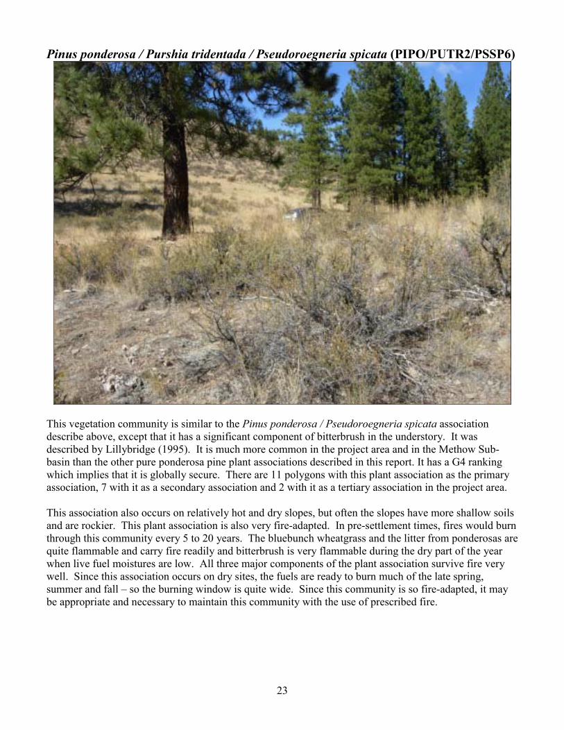
Pinus ponderosa / Purshia tridentada / Pseudoroegneria spicata (PIPO/PUTR2/PSSP6)
This vegetation community is similar to the Pinus ponderosa / Pseudoroegneria spicata association describe above, except that it has a significant component of bitterbrush in the understory. It was described by Lillybridge (1995). It is much more common in the project area and in the Methow Sub-basin than the other pure ponderosa pine plant associations described in this report. It has a G4 ranking which implies that it is globally secure. There are 11 polygons with this plant association as the primary association, 7 with it as a secondary association and 2 with it as a tertiary association in the project area. This association also occurs on relatively hot and dry slopes, but often the slopes have more shallow soils and are rockier. This plant association is also very fire-adapted. In pre-settlement times, fires would burn through this community every 5 to 20 years. The bluebunch wheatgrass and the litter from ponderosas are quite flammable and carry fire readily and bitterbrush is very flammable during the dry part of the year when live fuel moistures are low. All three major components of the plant association survive fire very well. Since this association occurs on dry sites, the fuels are ready to burn much of the late spring, summer and fall � so the burning window is quite wide. Since this community is so fire-adapted, it may be appropriate and necessary to maintain this community with the use of prescribed fire.
24
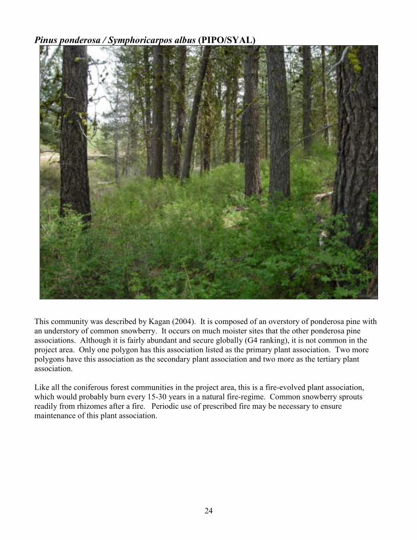
Pinus ponderosa / Symphoricarpos albus (PIPO/SYAL)
This community was described by Kagan (2004). It is composed of an overstory of ponderosa pine with an understory of common snowberry. It occurs on much moister sites that the other ponderosa pine associations. Although it is fairly abundant and secure globally (G4 ranking), it is not common in the project area. Only one polygon has this association listed as the primary plant association. Two more polygons have this association as the secondary plant association and two more as the tertiary plant association. Like all the coniferous forest communities in the project area, this is a fire-evolved plant association, which would probably burn every 15-30 years in a natural fire-regime. Common snowberry sprouts readily from rhizomes after a fire. Periodic use of prescribed fire may be necessary to ensure maintenance of this plant association.

25
Pinus ponderosa / Symphoricarpos oreophilus (PIPO/SYOR2)
This plant association was described by Kagan (2004). It is similar to the Pinus ponderosa / Symphoricarpos albus association, except that mountain snowberry replaces common snowberry. It is not common in the project area, but is probably abundant and secure on a global basis (~G5 rank). In the project area, it occurs in small, dry swales and some other more mesic portions of south-facing slopes. Like all the coniferous forest communities in the project area, this is a fire-evolved plant association, which would probably burn every 15-30 years in a natural fire-regime. As with common snowberry , mountain snowberry sprouts readily from rhizomes after a fire. Periodic use of prescribed fire may be necessary to ensure maintenance of this plant association.

26
Pinus ponderosa - Pseudotsuga menziesii / Calamagrostis rubescens (PIPO-PSME/CARU)
This plant association was described by Bourgeron (1994). It is similar to the Pinus ponderosa / Calamagrostis rubescens association described previously. However, the addition of Douglas-fir in the overstory is a key distinguishing characteristic. The presence of Douglas-fir indicates a slightly cooler and moister site than where we find the Pinus ponderosa / Calamagrostis rubescens association, and its presence may also be a consequence of human supression of the natural fire cycle. It is also very similar to the Pseudotsuga menziesii / Calamagrostis rubescens association described by Lillybridge (1995). In fact, Lillybridge�s PSME/CARU plant association applies to stands containing both tree species and stands of pure Douglas-fir. His assumption is that with the exclusion of fire and because of the shade tolerance of Douglss-fir, the mixed stands will eventually become pure stands of Douglas-fir. This association has a G2 rank, which implies that it is globally imperiled due to restricted range, very few populations, and/or steep declines, and other factors. It is a relativley common community type in the Methow Sub-basin, and in the project area, but it deserves consideration for special protection due to its global conservation status.

27
Pinus ponderosa - Pseudotsuga menziesii / Pseudoroegneria spicata (PIPO-PSME/PSSP6) This is a mixed forest of ponderosa pine and Douglas-fir with an understory of bluebunch wheatgrass and was described by Bourgeron (1994). It is similar to the Pinus ponderosa / Pseudoroegneria spicata association described above, with the inclusion of Douglas-fir in the overstory. It is also similar to the Pseudotsuga menziesii / Pseudoroegneria spicata association described by Lillybridge (1995). This plant association occupies relatively dry, cool forested sites in the study area. The forest overstory is usually quite open. This plant association has a G3 global status that indicates that it is rare and somewhat vulernable. The absence of bitterbrush may well be a result of fairly recent fires in the Methow Wildlife Area. Without fire, the plant community composition would probably shift to having more bitterbrush in the understory and more Douglas-fir in the overstory � more like the Pseudotsuega menziesii / Purshia tridentata / Pseudoroegneria spicata plant association described later in this report. Pinus ponderosa - Pseudotsuega menziesii / Purshia tridentata (PIPO-PSME/PUTR2) This plant association is similar to the one described above, but has an additional significant bitterbrush shrub understory. It is also similar to the Pinus ponderosa / Purshia tridentada / Pseudoroegneria spicata association and the Pseudotsuega menziesii / Purshia tridentata / Pseudoroegneria spicata association. It was described by Bourgeron (1994), and has a G3 global status which implies that it is rare and vulnerable. As mentioned in the description above, this plant community may occur where bitterbrush has become more common after years of fire suppression.

28
Prunus virginiana �Amelanchier alnifolia � Purshia tridentata / Pseudoroegneria spicata (PRVI � AMAL2 � PUTR2 / PSSP6)
This plant community describes small patches of chokecherry mixed with serviceberry and bitterbrush and an understory of bluebunch wheatgrass. Although it is not recorded in existing literature, PBI decided that it was a unique community that warranted a name and description. The patches have varying compostition, but chokecherry is always present and best characterizes this community. The global rank is not known, but its occurence is infrequent within the Methow-subbasin and should probably be considered regionally scarce. These small chokecherry � serviceberry patches can occur on otherwise warm, dry, well drained slopes, where there is enough accessible underground water to support chokecherry and serviceberry. It should be considered a variant of the Purshia tridentata / Pseudoroegneria spicata association described below that occurs on micro-sites.

29
Pseudotsuga menziesii / Calamagrostis rubescens (PSME/CARU)
This is locally a common plant association in the Methow Sub-basin, and is globally abundant and secure (G5 rank). The overstory is dominated by Douglas-fir with an understory of pinegrass. It was described by Lillybridge (1995). This plant association is similar to the Pinus ponderosa / Calamagrostis rubescens and Pinus ponderosa - Pseudotsuga menziesii / Calamagrostis rubescens associations, but ponderosa pine is less abundant or completely absent in this association. It occurs on slightly to more cooler sites than the communities containing pure ponderosa pine. In some cases, where there is a dense overstory, such as the site where the above photo was taken, pinegrass cover can be very sparse.

30
Pseudotsuga menziesii / Calamagrostis rubescens - Pseudoroegneria spicata (PSME/CARU-PSSP6) Ths plant community is also fairly common in the Methow Sub-basin and is probably secure globally. It was described by Lillybridge (1995). It is very similar to the Pseudotsuga menziesii / Calamagrostis rubescens association, with the inclusion of bluebunch wheatgrass in the understory. It occurs on somewhat drier and better drained sites than the Pseudotsuga menziesii / Calamagrostis rubescens association. Pseudotsuega menziesii / Purshia tridentata / Calamagrostis rubescens (PSME/PUTR2/CARU) This community is similar to the Pseudotsuega menziesii / Calamagrostis rubescens described above, but has a significant component of bitterbrush in the understory. It was described by Lillybridge (1995). It may result from fire exclusion in stands that were previously more characteristic of the Pseudotsuega menziesii / Calamagrostis rubescens association. Fire exclusion would allow bitterbrush to more successfully compete in the forest understory. Pseudotsuega menziesii / Purshia tridentata / Pseudoroegneria spicata (PSME/PUTR2/PSSP6)
This plant community is similar to the previous community, but pinegrass is replaced by bluebunch wheatgrass in the understory. It was described by Lillybridge (1995). It occurs on drier sites than the previous community. It is similar to the Pinus ponderosa / Purshia tridentada / Pseudoroegneria spicata community except that Douglas-fir replaces ponderosa pine in the overstory.
Pseudotsuga menziesii / Spiraea betulifolia (PSME/SPBE2) This community is characterized by an overstory of Douglas-fir and an understory dominated by shiny-leaf spiraea. It was described by Lillybridge (1995). It is common in the Methow and secure globally. This association occurs on moderately mesic, cool slopes, with good drainage and often relatively thin soils. It is quite common on adjacent national forest lands.

31
Pseudotsuga menziesii / Spiraea betulifolia / Calamagrostis rubescens (PSME/SPBE2/CARU)
This association is very similar to the previously described association, with the addition of pinegrass in the understory. It was described by Lillybridge (1995). It is also common in the Methow and secure globally. It occurs on slopes with more soil depth than the previous association which lacks pinegrass.
Pseudotsuga menziesii / Symphoricarpos albus (PSME/SYAL) This plant association was described by Lillybridge (1995). It is a common association in the Methow Valley. It is similar to the Pinus ponderosa / Symphoricarpos albus association, except that Douglas-fir replaces ponderosa pine in the overstory. It can be found on sites that are higher elevation and somewhat cooler than the Pinus ponderosa / Symphoricarpos albus association.

32
Pseudotsuga menziesii / Symphoricarpos albus / Calamagrostis rubescens (PSME/SYAL/CARU)
This association is very similar to the previously described association with the addition of pinegrass in the understory. It was described by Lillybridge (1995) and is common in the Methow and secure globally. Pseudotsuga menziesii / Symphoricarpos albus / Pseudoroegneria spicata (PSME/SYAL/PSSP6)
This association is similar to the previously described association, except that bluebunch wheatgrass replaces pinegrass. It was described by Lillybridge (1995).

33
Pseudotsuga menziesii / Symphoricarpos oreophilus (PSME/SYOR2)
This plant association is characterized by an overstory of Douglas-fir with an understory of mountain snowberry. It was described by Lillybridge (1995). It is relatively abundant in the Methow and is globally abundant and secure (G5 rank). It is very similar to the Pseudotsuga menziesii / Symphoricarpos albus association described above, but mountain snowberry replaces common snowberry. It occurs on somewhat drier, cool slopes.

34
Pseudoroegneria spicata - Balsamorhiza sagittata (PSSP6-BASA3)
This non-forested association is part of the meadow-steppe assembledge of the Methow Valley. It is characterized by the dominance of bluebunch wheatgrass and arrowleaf balsamroot cover and the absence of shrub and/or tree cover. The most similar published plant association matching this community type in the Methow Sub-basin is the Bluebunch wheatgrass - Arrowleaf balsamroot - Curly bluegrass (Poa secunda) association described by Kagan (2004). However Poa secunda does not occur on this site, nor has it been identified within any of the 2006 or 2007 project areas. The Poa secunda phase of this plant community does infrequently occur elsewhere in the Methow Valley, but it is a globally imperiled community with a conservation rank of G2. Both the PSSP6-BASA3 and PSSP6-BASA3-POSE communities are very sensitive to damage due to livestock grazing and motorized recreational use and areas of these communities with low exotic plant cover should be protected from unnatural disturbances. These plant associations grade into and mosaic with another closely related community type, this one dominated by bitterbrush (seen at the top part of the photo above). The bitterbrush phase of this plant association was described by Wooten and Morrison (2005) from four ecology plots in the Methow Valley. Historic fires probably helped impede bitterbrush establishment on the meadow-steppe phases of this larger steppe community complex.

35
Pseudoroegneria spicata - Eriogonum heracleoides (PSSP6-ERHE2)
This non-forested association is part of the meadow-steppe assembledge found in the Methow Sub-basin. It is characterized by the codominance of bluebunch wheatgrass and parsnip-flowered wild-buckwheat. This plant association is the Methow phase of a broad community type described within the Columbia Basin by Kagan (2004) and Johnson and Simon (1987). This plant community is uncommon in the Methow and has a G2 global rank, which implies that it is imperiled globally. The wild-buckwheat component of this community is very sensitive to damage due to livestock grazing and motorized recreational use. Since this community is imperiled globally and so rare in the Methow it should be targeted for special management attention and conflicting uses should be carefully controlled.
36
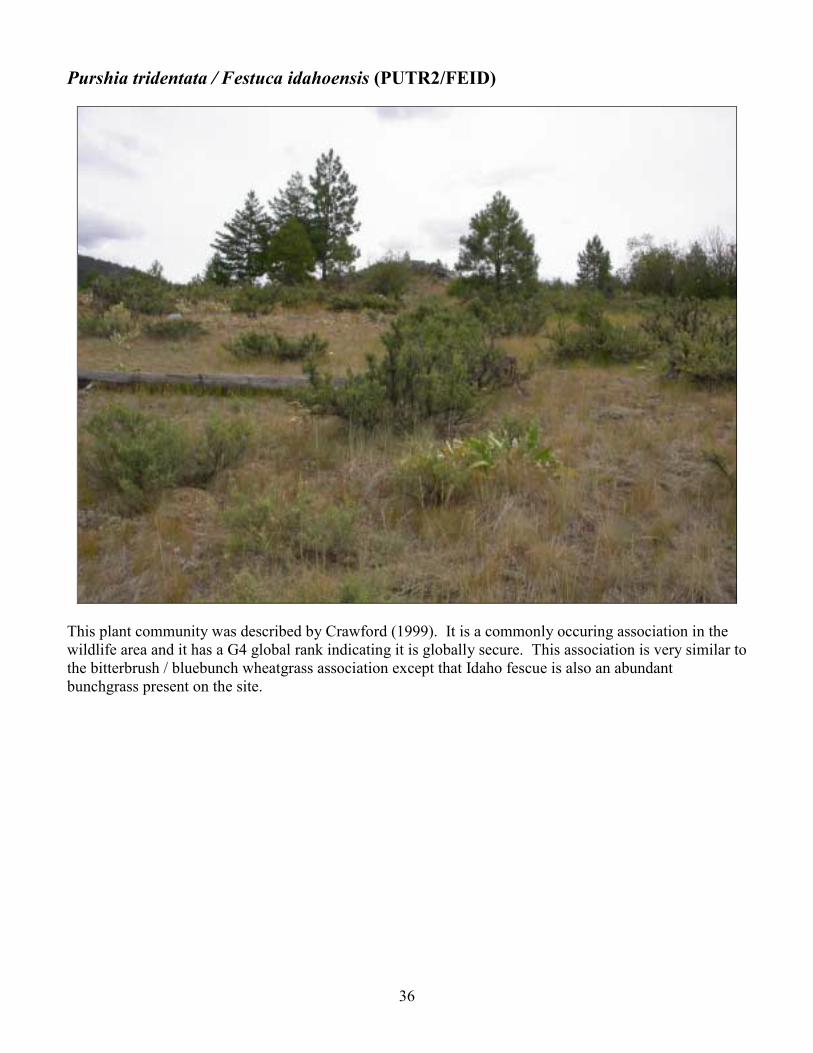
Purshia tridentata / Festuca idahoensis (PUTR2/FEID)
This plant community was described by Crawford (1999). It is a commonly occuring association in the wildlife area and it has a G4 global rank indicating it is globally secure. This association is very similar to the bitterbrush / bluebunch wheatgrass association except that Idaho fescue is also an abundant bunchgrass present on the site.

37
Purshia tridentata / Pseudoroegneria spicata (PUTR2/PSSP6)
This association was describe by Crawford (1999). It is considered globally vulnerable to extirpation or extinction (G3 rank), but is the most abundant plant association in the project area. This is the dominant shrub-steppe community in the Methow Sub-basin. It is another fire-evolved community, with a natural fire-return interval of 8-15 years. As with the bluebunch wheatgrass / arrowleaf balsam root association, this plant community is very sensitive to damage due to livestock grazing and motorized recreational use and areas of these communities with low exotic plant cover should be protected from unnatural disturbances if good ecological conditions are going to be maintained.

38
Symphoricarpos albus - Rosa woodsii (SYAL-RONU)
Within the project area there occur some small shrubby patches or linear strips dominated by common snowberry and Nootka rose. These shrubland communities were described by Kagan (2004). They are relatively uncommon, rare and vulnerable globally (G3 rank). Generally, these small patches occur in the shrub-steppe matrix where there are moister, but still well drained pockets on otherwise dry slopes and flats. Often these patches occur at the border of aspen stands where there is a transition from a drier to a wetter community. Some patches are mostly dominated by Nootka rose, while others are dominated by common snowberry. In other patches, snowberry dominates one portion and rose, another portion.
39
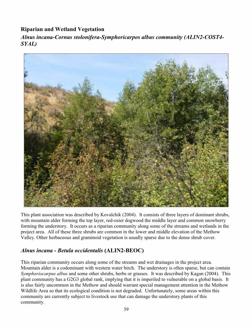
Riparian and Wetland Vegetation Alnus incana-Cornus stolonifera-Symphoricarpos albus community (ALIN2-COST4-SYAL)
This plant association was described by Kovalchik (2004). It consists of three layers of dominant shrubs, with mountain alder forming the top layer, red-osier dogwood the middle layer and common snowberry forming the understory. It occurs as a riparian community along some of the streams and wetlands in the project area. All of these three shrubs are common in the lower and middle elevation of the Methow Valley. Other herbaceous and graminoid vegetation is usually sparse due to the dense shrub cover. Alnus incana - Betula occidentalis (ALIN2-BEOC) This riparian community occurs along some of the streams and wet drainages in the project area. Mountain alder is a codominant with western water birch. The understory is often sparse, but can contain Symphoriocarpus albus and some other shrubs, herbs or grasses. It was described by Kagan (2004). This plant community has a G2G3 global rank, implying that it is imperiled to vulnerable on a global basis. It is also fairly uncommon in the Methow and should warrant special management attention in the Methow Wildlife Area so that its ecological condition is not degraded. Unfortunately, some areas within this community are currently subject to livestock use that can damage the understory plants of this community.
40
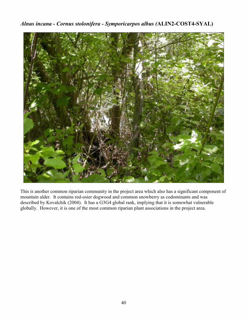
Alnus incana - Cornus stolonifera - Symporicarpos albus (ALIN2-COST4-SYAL)
This is another common riparian community in the project area which also has a significant component of mountain alder. It contains red-osier dogwood and common snowberry as codominants and was described by Kovalchik (2004). It has a G3G4 global rank, implying that it is somewhat vulnerable globally. However, it is one of the most common riparian plant associations in the project area.

41
Phalaris arundinacea (PHAR3)
This type of wetland community is dominated by the invasive, non-native reed canarygrass. It occurs in shallow water and along the mucky shorelines of Cougar Lake in the project area. Phalaris arundinacea is the dominant plant cover. However, many other native and non-native wetland graminoid and herbaceous species may occur interspersed. Phalaris arundinacea seems to be well established around the perimeter of Cougar Lake, and although full eradication of the grass through targeted hand pulling and removal probably isn�t realistic, control of the spread of the infestation into more pristine parts of the lake shore may be feasible using a targeted hand-pulling program.

42
Populus trichocarpa / Alnus incana - Cornus stolonifera, (POTR15/ALIN2-COST4) This plant association was described by Kovalchik (2004). It is a wetland/riparian community and is not common in the project area. While the occurrence of mountain alder and red-oiser dogwood is common in many of the riparian wetlands throughout the Methow Wildlife Area, the presence of black cottonwoods is far less frequent. This community is compositionally similar to the ALIN2-COST4-SYAL shrubland community. However, the presence of black cottonwood as an overstory component differentiates this community. The large cottonwoods can play an important ecological role because they provide elevated perches for hunting birds of prey, and protective roosts and nesting opportunities to some bird species. Overall this community is relatively common in the Methow, but has a G3 global rank, implying that it is vulnerable globally.

43
Populus tremuloides / Cornus stolonifera (POTR5/COST4)
This riparian plant community is characterized by an overstory of trembling aspen and an understory of red-osier dogwood. It grows adjacent to small streams in the project area and was described by Kovalchik (2004). It is stable and well distributed globally (G4 rank) and fairly common in the Methow.

44
Populus tremuloides / Symphoricarpos albus (POTR5/SYAL)
This riparian plant community is characterized by an overstory of trembling aspen and an understory of common snowberry. It grows in moist pockets and swales, sometimes as a linear strip at the outer border of riparian areas in the project area. It should be considered to be transitional between the riparian systems and the uplands. It was described by Kovalchik (2004). Areas that are covered by this association are usually fairly moist, at least in the spring, and have reasonably deep soils. It is globally vulnerable to extirpation or extinction (G3 status) and only occurs in small pockets throughout the Methow. This association is very important for many wildlife species. It should be managed carefully to avoid resource damage.

45
Salix bebbiana (SABE2)
This riparian plant community is characterized by dense thickets of Bebb willow. It was found in one polygon in the project area (on the eastern border) where a small pond is situated. Scattered occurrences of Bebb willow occur along the margins of most ponds in this area, but they seldom attain stand-level dominance. The community is situated in a swampy depression with a high water table and spring ponding. It was described by Bourgeron (2004) and Crawford (2003). The understory of the pond site where this community is dominant has been thoroughly invaded by non-native Poa pratensis, but still has native Maianthemum stellatum present. This plant association is vulnerable globally (G3 rank) and uncommon in the Methow, where it is limited to lower elevation wetlands and meadows, typically with calcic soils. It should be targeted for special management attention to avoid deterioration of its ecological condition.

46
Other Land Cover Types Former agricultural field
Part of the project area was an old homestead and agricultural land in the past. Some of the fields have been abandoned for years, and are in transition back to native vegetation. Other fields have been more actively managed by WDFW in recent years and do not have significant native vegetation. Most of the former agricultural fields are dominated by non-native species, which often comprise 50 to 95% of the vegetation cover. The primary non-native species are smooth brome (Bromus inermis), cheatgrass (Bromus tectorum), and diffuse knapweed (Centauria diffusa), although many others are present as well.

47
Disturbed meadow / grassland
These areas contain little shrub cover and are dominated by graminoids. They often occur in relatively level areas and may be sub-irrigated in the spring by water moving through the soil. They may also represent very old agricultural fields that have largely recovered to the point of having mostly native plant cover. Regardless, these plant communities are markedly different from the surrounding shrub-steppe. These areas often stay green later into summer than the shrub-steppe, and are therefore much more heavily grazed by cattle, with a resultant potential loss of a native species. Often non-native species are common and abundant in these areas.

48
Disturbed wetland
There are disturbed vernal wetlands in the project area that occur in shallow depressions where moisture accumulates in the springtime. Because of the moisture that accumulates at these sites, they are favored by grazing cattle in the summer, as the surrounding uplands dry out. Often heavy grazing occurs and the result is extensive disturbance to these wetland communities and invasion of non-native species. Over time, with the removal of grazing pressure, these areas would probably favor many more native species. We have found rare, listed plant species in similar areas in nearby areas of Pearrygin Lake State Park that have not been grazed for many years.
49
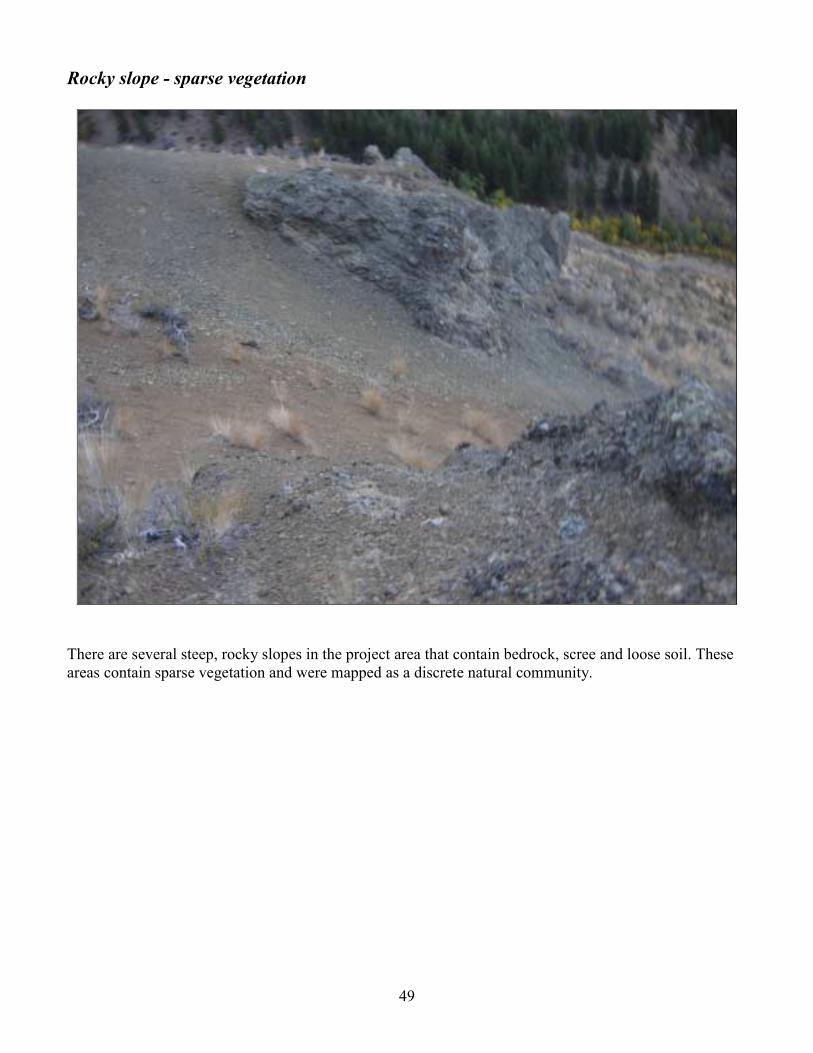
Rocky slope - sparse vegetation
There are several steep, rocky slopes in the project area that contain bedrock, scree and loose soil. These areas contain sparse vegetation and were mapped as a discrete natural community.

50
Talus slope
There is at least one sizeable talus slope in the project area above and east of Cougar Lake. It contains large talus blocks and very sparse vegetation.

51
Tree plantation There is one polygon in the project area that was former agricultural field, a portion of which now contains a young plantation of ponderosa pine. The pine is spaced evenly and the understory is similar to the vegetation of the surrounding field. It is not a natural community; therefore we decided to map and describe it as a discrete entity.

52
Water
Cougar Lake is the one significant waterbody in the project area. There are also some small streams, but these are included in the riparian vegetation community surrounding the stream and too narrow to be considered mapable vegetation communities by themselves.

53
Rare Plant Surveys
Methods We visited the project area of the Methow Wildlife Area multiple times during the 2007 field season to conduct rare plant surveys. We used the Washington Department of Natural Resources Natural Heritage Program�s (DNR NHP) rare plant list to determine the conservation status of vascular plants encountered in the field. When a plant from the DNR NHP list was located, we used the standard DNR NHP rare plant sighting form to complete field descriptions for the observation. Field surveys were conducted on : April 15, May 12, June 6, June 7, July 3, July 7, July 21, September 6, September 7, September 26, October 3, October 5, October 6, October 8, October 11, October 12, and October 19. During the field surveys, we were equipped with reference literature, rare plant lists for the area, maps showing rare plant locations from previous surveys, and a portable plant identification lab. We looked for rare plants in habitats previously identified as being likely occurrence sites. So as not to miss a rare plant, all vascular plant species encountered during the inventory were identified on site, at base camp in the portable laboratory, or back at our office. Survey routes were determined based on the desire to efficiently cover a large proportion of the park�s area throughout the field season. We surveyed habitats of the park where we felt rare plants were more likely to occur more intensively. Survey routes for the rare plant inventory and rare plant locations were recorded either by hand, on a hardcopy topographic map, or as GPS waypoints and trackpoints, all of which were later compiled into a single GIS data layer, depicted in Appendix A.
Results
Rare Plants No plant species listed as threatened, endangered or sensitive were encountered in the project area. One species on the WA DNR NHP �watch� list was encountered, purple milkvetch (Astragalus agrestis). Watch status is assigned to each vascular plant taxon that is more abundant and/or less threatened in Washington than previously assumed. Although the Washington Natural Heritage Program does not focus on these taxa, some information about them is still gathered. Scientific Name Common Name Global/State Rank Astragalus agrestis Purple milkvetch G5 (Globally Secure) / Watch

54
Vascular Plant List for the 2007 Project Area A total of 251 vascular plant species were identified during the 2007 surveys in the Methow Wildlife Area. Of these, 46 of the plant species are non-native, accounting for 18% of the total. Key to Vascular Plant Species List Column 2: �Code�: Four-letter plant code as shown on the USDA PLANTS database. Column 3: �Hitchcock Scientific Name�: The species list primarily uses Hitchcock and Cronquist�s Flora of the Pacific Northwest as the taxonomic authority, as this is still the standard reference for our area. Column 4: �New Scientific Name�: Updated nomenclature when it exists is shown in column 4. When updated nomenclature is an integral part of a community plant association, then the updated version appears in the association name and the new 4 letter code is not reflected in this table. Column 7: �Alien�: species that are not native to the Methow Wildlife Area are indicated with an �a� in this column.

55
Vascular Plant Species of the Project Area, MWA: Code Hitchcock Scientific Name New Scientific Name Common Name Family Alien
1 ACGL Acer glabrum Torr. Rocky Mountain maple Aceraceae 2 ACMI2 Achillea millefolium L. common yarrow Asteraceae 3 ACRU2 Actaea rubra (Ait.) Willd. red baneberry Ranunculaceae
4 AGUR Agastache urticifolia (Benth.) Kuntze nettleleaf giant hyssop Lamiaceae
5 AGGL Agoseris glauca (Pursh) Raf. pale agoseris Asteraceae
6 AGCR Agropyron cristatum (L.) Gaertn. crested wheatgrass Poaceae a
7 AGSP Agropyron spicatum Pursh
Pseudoroegneria spicata (Pursh) A. Löve ssp. spicata bluebunch wheatgrass Poaceae
8 AGAL3 Agrostis alba auct. non L. [misapplied] Agrostis gigantea Roth redtop Poaceae a
9 AGSC5 Agrostis scabra Willd. rough bentgrass Poaceae 10 ALPL Alisma plantago-aquatica L. European water plantain Alismataceae a 11 ALIN2 Alnus incana (L.) Moench gray alder Betulaceae
12 AMAL2 Amelanchier alnifolia (Nutt.) Nutt. ex M. Roemer Saskatoon serviceberry Rosaceae
13 ANMA Anaphalis margaritacea (L.) Benth. western pearly everlasting Asteraceae
14 ANAR3 Angelica arguta Nutt. Lyall's angelica Apiaceae
15 ANLU2 Antennaria luzuloides Torr. & Gray rush pussytoes Asteraceae
16 ANMI3 Antennaria microphylla Rydb. littleleaf pussytoes Asteraceae 17 ANRA Antennaria racemosa Hook. raceme pussytoes Asteraceae 18 APAN2 Apocynum androsaemifolium L. spreading dogbane Apocynaceae 19 ARHO2 Arabis holboellii Hornem. Holboell's rockcress Brassicaceae 20 ARSP Arabis sparsiflora Nutt. sicklepod rockcress Brassicaceae
21 ARCA3 Arceuthobium campylopodum Engelm. western dwarf mistletoe Loranthaceae
22 ARDO Arceuthobium douglasii Engelm. Douglas dwarf mistletoe Loranthaceae 23 ARMI2 Arctium minus Bernh. lesser burdock Asteraceae a
24 ARNE Arctostaphylos nevadensis Gray pinemat manzanita Ericaceae 25 ARCO9 Arnica cordifolia Hook. heartleaf arnica Asteraceae 26 ARAN3 Artemisia annua L. sweet sagewort Asteraceae a 27 ARDR4 Artemisia dracunculus L. tarragon Asteraceae a 28 ARTR2 Artemisia tridentata Nutt. big sagebrush Asteraceae 29 ARTR4 Artemisia tripartita Rydb. threetip sagebrush Asteraceae
30 ASCO3 Aster conspicuus Lindl. Eurybia conspicua (Lindl.) Nesom western showy aster Asteraceae
31 ASLAG Aster laevis L. var. geyeri Gray Symphyotrichum laeve var. geyeri Asteraceae
32 ASAG2 Astragalus agrestis Dougl. ex G. Don purple milkvetch Fabaceae
33 ASMI9 Astragalus miser Dougl. timber milkvetch Fabaceae
34 ASPU9 Astragalus purshii Dougl. ex Hook. woollypod milkvetch Fabaceae
35 BASA3 Balsamorhiza sagittata (Pursh) Nutt. arrowleaf balsamroot Asteraceae
36 BEOC2 Betula occidentalis Hook. water birch Betulaceae 37 BEPA Betula papyrifera Marsh. paper birch Betulaceae
38 BRBR7 Bromus brizaeformis Fischer & C. Meyer
Bromus briziformis Fisch. & C.A. Mey. rattlesnake brome Poaceae a
39 BRCA5 Bromus carinatus Hook. & Arn. California brome Poaceae 40 BRCO4 Bromus commutatus Schrad. Bromus racemosus L. bald brome Poaceae a

56
Code Hitchcock Scientific Name New Scientific Name Common Name Family Alien 41 BRIN2 Bromus inermis Leyss. smooth brome Poaceae a
42 BRJA Bromus japonicus Thunb. ex Murr. Bromus arvensis field brome Poaceae
43 BRSE Bromus secalinus L. rye brome Poaceae a 44 BRTE Bromus tectorum L. cheatgrass Poaceae a 45 CARU Calamagrostis rubescens Buckl. pinegrass Poaceae 46 CALY Calochortus lyallii Baker Lyall's mariposa lily Liliaceae
47 CAMA5 Calochortus macrocarpus Dougl. sagebrush mariposa lily Liliaceae 48 CABU Calypso bulbosa (L.) Oakes fairy slipper Orchidaceae 49 CADR Cardaria draba (L.) Desv. whitetop Brassicaceae a
50 CAPU6 Cardaria pubescens (C.A. Mey.) Jarmolenko hairy whitetop Brassicaceae a
51 CAAM10 Carex amplifolia Boott bigleaf sedge Cyperaceae 52 CADO2 Carex douglasii Boott Douglas' sedge Cyperaceae 53 CAHO5 Carex hoodii Boott Hood's sedge Cyperaceae 54 CAMU6 Carex multicostata Mackenzie manyrib sedge Cyperaceae 55 CAPR5 Carex praegracilis W. Boott clustered field sedge Cyperaceae 56 CARO5 Carex rossii Boott Ross' sedge Cyperaceae 57 CAHI9 Castilleja hispida Benth. harsh Indian paintbrush Scrophulariaceae 58 CAMI12 Castilleja miniata Dougl. ex Hook. giant red Indian paintbrush Scrophulariaceae
59 CATH4 Castilleja thompsonii Pennell Thompson's Indian paintbrush Scrophulariaceae
60 CEVE Ceanothus velutinus Dougl. ex Hook. snowbrush ceanothus Rhamnaceae
61 CEDI3 Centaurea diffusa Lam. diffuse knapweed Asteraceae a
62 CHDO Chaenactis douglasii (Hook.) Hook. & Arn. Douglas' dustymaiden Asteraceae
63 CHFR3 Chenopodium fremontii S. Wats. Fremont's goosefoot Chenopodiaceae
64 CHLE4 Chenopodium leptophyllum (Moq.) Nutt. ex S. Wats. narrowleaf goosefoot Chenopodiaceae
65 CHUM Chimaphila umbellata (L.) W. Bart. pipsissewa Pyrolaceae
66 CILA2 Cinna latifolia (Trev. ex Goepp.) Griseb. drooping woodreed Poaceae
67 CIAL Circaea alpina L. small enchanter's nightshade Onagraceae
68 CIAR4 Cirsium arvense (L.) Scop. Canada thistle Asteraceae a
69 CIUN Cirsium undulatum (Nutt.) Spreng. wavyleaf thistle Asteraceae
70 CLLA2 Claytonia lanceolata Pall. ex Pursh lanceleaf springbeauty Portulacaceae
71 CLLI2 Clematis ligusticifolia Nutt. western white clematis Ranunculaceae 72 COPA3 Collinsia parviflora Lindl. maiden blue eyed Mary Scrophulariaceae 73 COLI2 Collomia linearis Nutt. tiny trumpet Polemoniaceae 74 COTE Collomia tenella Gray diffuse collomia Polemoniaceae 75 COUM Comandra umbellata (L.) Nutt. bastard toadflax Santalaceae 76 COAR4 Convolvulus arvensis L. field bindweed Convolvulaceae a
77 COST4 Cornus stolonifera Michx. Cornus sericea L. ssp. sericea redosier dogwood Cornaceae
78 CRCO6 Crataegus columbiana T.J. Howell
Crataegus douglasii Lindl. black hawthorn Rosaceae
79 CRAT Crepis atribarba Heller slender hawksbeard Asteraceae 80 CRIN4 Crepis intermedia Gray limestone hawksbeard Asteraceae
81 CRTO4 Cryptantha torreyana (Gray) Greene Torrey's cryptantha Boraginaceae
82 CUAP2 Cuscuta approximata Bab. alfalfa dodder Cuscutaceae a
83 CYMO2 Cypripedium montanum Dougl. ex Lindl. mountain lady's slipper Orchidaceae

57
Code Hitchcock Scientific Name New Scientific Name Common Name Family Alien 84 CYFR2 Cystopteris fragilis (L.) Bernh. brittle bladderfern Dryopteridaceae 85 DAGL Dactylis glomerata L. orchardgrass Poaceae a
86 DENU2 Delphinium nuttallianum Pritz. ex Walp. twolobe larkspur Ranunculaceae
87 DEPI Descurainia pinnata (Walt.) Britt. western tansymustard Brassicaceae
88 DITR2 Disporum trachycarpum (S. Wats.) Benth. & Hook. f.
Prosartes trachycarpa S. Wats. roughfruit fairybells Liliaceae
89 DOPU Dodecatheon pulchellum (Raf.) Merr. darkthroat shootingstar Primulaceae
90 EPAN2 Epilobium angustifolium L.
Chamerion angustifolium (L.) Holub ssp. angustifolium fireweed Onagraceae
91 EPMI Epilobium minutum Lindl. ex Lehm. chaparral willowherb Onagraceae
92 EPPA2 Epilobium paniculatum Nutt. ex Torr. & Gray Epilobium brachycarpum tall annual willowherb Onagraceae
93 EQLA Equisetum laevigatum A. Braun smooth horsetail Equisetaceae 94 ERCO5 Erigeron corymbosus Nutt. longleaf fleabane Asteraceae 95 ERFI2 Erigeron filifolius (Hook.) Nutt. threadleaf fleabane Asteraceae 96 ERLI Erigeron linearis (Hook.) Piper desert yellow fleabane Asteraceae 97 ERPU2 Erigeron pumilus Nutt. shaggy fleabane Asteraceae
98 ERSUC
Erigeron subtrinervis Rydb. ex Porter & Britt. var. conspicuus (Rydb.) Cronq. threenerve fleabane Asteraceae
99 ERHE2 Eriogonum heracleoides Nutt. parsnipflower buckwheat Polygonaceae
100 ERNI2 Eriogonum niveum Dougl. ex Benth. snow buckwheat Polygonaceae
101 ERUM Eriogonum umbellatum Torr. sulphur-flower buckwheat Polygonaceae 102 FEID Festuca idahoensis Elmer Idaho fescue Poaceae
103 FEOV2 Festuca ovina auct. non L. [misapplied]
Festuca brachyphylla J.A. Schultes ex J.A. & J.H. Schultes ssp. brachyphylla alpine fescue Poaceae
104 FRVI Fragaria virginiana Duchesne Virginia strawberry Rosaceae 105 GABO2 Galium boreale L. northern bedstraw Rubiaceae 106 Galium sp. Rubiaceae 107 GATR3 Galium triflorum Michx. fragrant bedstraw Rubiaceae
108 GADI2 Gayophytum diffusum Torr. & Gray spreading groundsmoke Onagraceae
109 GEVI2 Geranium viscosissimum Fisch. & C.A. Mey. ex C.A. Mey. sticky purple geranium Geraniaceae
110 GETR Geum triflorum Pursh old man's whiskers Rosaceae
111 GIAG Gilia aggregata (Pursh) Spreng.
Ipomopsis aggregata (Pursh) V. Grant ssp. aggregata scarlet gilia Polemoniaceae
112 HAUN Habenaria unalascensis (Spreng.) S. Wats. Piperia unalascensis Orchidaceae
113 HAAR3 Hackelia arida (Piper) I.M. Johnston
Hackelia diffusa (Lehm.) I.M. Johnston var. arida (Piper) R.L. Carr sagebrush stickseed Boraginaceae
114 HAWH Halimolobos whitedii (Piper) Rollins Whited's fissurewort Brassicaceae
115 HABL3 Haplopappus bloomeri Gray Ericameria bloomeri (Gray) J.F. Macbr. rabbitbush Asteraceae
116 HEUND
Helianthella uniflora (Nutt.) Torr. & Gray var. douglasii (Torr. & Gray) W.A. Weber Douglas' helianthella Asteraceae
117 HEPE Helianthus petiolaris Nutt. prairie sunflower Asteraceae
118 HECY2 Heuchera cylindrica Dougl. ex Hook. roundleaf alumroot Saxifragaceae

58
Code Hitchcock Scientific Name New Scientific Name Common Name Family Alien 119 HISC2 Hieracium scouleri Hook. Scouler's woollyweed Asteraceae 120 HIUM Hieracium umbellatum L. narrowleaf hawkweed Asteraceae
121 HODI Holodiscus discolor (Pursh) Maxim. oceanspray Rosaceae
122 HYCA4 Hydrophyllum capitatum Dougl. ex Benth. ballhead waterleaf Hydrophyllaceae
123 HYPE Hypericum perforatum L. common St. Johnswort Clusiaceae a
124 IVXA Iva xanthifolia Nutt. Cyclachaena xanthifolia (Nutt.) Fresen. giant sumpweed Asteraceae a
125 JUBA Juncus balticus Willd.
Juncus arcticus Willd. ssp. littoralis (Engelm.) Hultén Baltic rush Juncaceae
126 JUCO6 Juniperus communis L. common juniper Cupressaceae
127 KOCR Koeleria cristata auct. p.p., non Pers.
Koeleria macrantha (Ledeb.) J.A. Schultes prairie Junegrass Poaceae
128 LASE Lactuca serriola L. prickly lettuce Asteraceae a 129 LAEC Lappula echinata Gilib. Lappula squarrosa European stickseed Boraginaceae a
130 LARE Lappula redowskii auct. non (Hornem.) Greene [misapplied]
Lappula occidentalis var. occidentalis flatspine stickseed Boraginaceae
131 LEVI3 Lepidium virginicum L. Virginia pepperweed Brassicaceae 132 LERE7 Lewisia rediviva Pursh bitter root Portulacaceae
133 LIPH3 Linanthus pharnaceoides (Benth.) Greene
Leptosiphon liniflorus (Benth.) J.M. Porter & L.A. Johnson narrowflower flaxflower Polemoniaceae
134 LIDA Linaria dalmatica (L.) P. Mill. Dalmatian toadflax Scrophulariaceae a 135 LIBU2 Lithophragma bulbiferum Rydb. Lithophragma glabrum bulbous woodland-star Saxifragaceae
136 LIAR4 Lithospermum arvense L. Buglossoides arvensis (L.) I.M. Johnston corn gromwell Boraginaceae a
137 LIRU4 Lithospermum ruderale Dougl. ex Lehm. western stoneseed Boraginaceae
138 LOAM Lomatium ambiguum (Nutt.) Coult. & Rose Wyeth biscuitroot Apiaceae
139 LODI Lomatium dissectum (Nutt.) Mathias & Constance fernleaf biscuitroot Apiaceae
140 LOGE2 Lomatium geyeri (S. Wats.) Coult. & Rose Geyer's biscuitroot Apiaceae
141 LOMA3 Lomatium macrocarpum (Nutt. ex Torr. & Gray) Coult. & Rose bigseed biscuitroot Apiaceae
142 LONU2 Lomatium nudicaule (Pursh) Coult. & Rose barestem biscuitroot Apiaceae
143 LOIN5 Lonicera involucrata (Richards.) Banks ex Spreng. twinberry honeysuckle Caprifoliaceae
144 LUPO2 Lupinus polyphyllus Lindl. bigleaf lupine Fabaceae 145 LUSE4 Lupinus sericeus Pursh silky lupine Fabaceae
146 LYAL Lychnis alba P. Mill.
Silene latifolia Poir. ssp. alba (P. Mill.) Greuter & Burdet bladder campion Caryophyllaceae a
147 LYBA4 Lycium barbarum L. matrimony vine Solanaceae a 148 MACI2 Madia citriodora Greene lemonscented madia Asteraceae
149 MAGR3 Madia gracilis (Sm.) Keck & J. Clausen ex Applegate grassy tarweed Asteraceae
150 MAAQ2 Mahonia aquifolium (Pursh) Nutt. hollyleaved barberry Berberidaceae 151 MARE11 Mahonia repens (Lindl.) G. Don creeping barberry Berberidaceae 152 MELU Medicago lupulina L. black medick Fabaceae a 153 MESA Medicago sativa L. alfalfa Fabaceae a
154 MEBU Melica bulbosa Geyer ex Porter & Coult. oniongrass Poaceae
155 MEOF Melilotus alba Medikus [orthographic variant]
Melilotus officinalis (L.) Lam. yellow sweetclover Fabaceae a

59
Code Hitchcock Scientific Name New Scientific Name Common Name Family Alien
156 MEAL6 Mentzelia albicaulis (Dougl. ex Hook.) Dougl. ex Torr. & Gray whitestem blazingstar Loasaceae
157 MELA2 Mentzelia laevicaulis (Dougl. ex Hook.) Torr. & Gray smoothstem blazingstar Loasaceae
158 MELO4 Mertensia longiflora Greene small bluebells Boraginaceae 159 MITR5 Microseris troximoides Gray Nothocalais troximoides weevil prairie-dandelion Asteraceae
160 MIGR Microsteris gracilis (Hook.) Greene slender phlox Polemoniaceae
161 MIGU Mimulus guttatus DC. seep monkeyflower Scrophulariaceae
162 MOLI4 Montia linearis (Dougl. ex Hook.) Greene narrowleaf minerslettuce Portulacaceae
163 MOPE3 Montia perfoliata (Donn ex Willd.) T.J. Howell
Claytonia perfoliata Donn ex Willd. ssp. perfoliata miner's lettuce Portulacaceae
164 MUAS Muhlenbergia asperifolia (Nees & Meyen ex Trin.) Parodi scratchgrass Poaceae
165 MUFI2 Muhlenbergia filiformis (Thurb. ex S. Wats.) Rydb. pullup muhly Poaceae
166 MYLA Myosotis laxa Lehm. bay forget-me-not Boraginaceae 167 NEBR Nemophila breviflora Gray basin nemophila Hydrophyllaceae 168 NECA2 Nepeta cataria L. catnip Lamiaceae a
169 OSCH Osmorhiza chilensis Hook. & Arn. Osmorhiza berteroi DC. sweetcicely Apiaceae
170 OSOC Osmorhiza occidentalis (Nutt. ex Torr. & Gray) Torr. western sweetroot Apiaceae
171 PAMY2 Pachystima myrsinites (Pursh) Raf. [orthographic variant]
Paxistima myrsinites (Pursh) Raf. Oregon boxleaf Celastraceae
172 PECO6 Penstemon confertus Dougl. ex Lindl. yellow penstemon Scrophulariaceae
173 PEFR3 Penstemon fruticosus (Pursh) Greene bush penstemon Scrophulariaceae
174 PEPR3 Penstemon pruinosus Dougl. ex Lindl. Chelan beardtongue Scrophulariaceae
175 PHHA Phacelia hastata Dougl. ex Lehm. silverleaf phacelia Hydrophyllaceae 176 PHHU Phacelia humilis Torr. & Gray low phacelia Hydrophyllaceae 177 PHLI Phacelia linearis (Pursh) Holz. threadleaf phacelia Hydrophyllaceae 178 PHAR3 Phalaris arundinacea L. reed canarygrass Poaceae a
179 PHOC3 Philotria occidentalis (Pursh) House Elodea nuttallii western waterweed Hydrocharitaceae
180 Photinia spp. chokeberry Rosaceae a 181 PIPO Pinus ponderosa P.& C. Lawson ponderosa pine Pinaceae 182 POBU Poa bulbosa L. bulbous bluegrass Poaceae a 183 POCO Poa compressa L. Canada bluegrass Poaceae a
184 PONE3 Poa nevadensis Vasey ex Scribn. Poa secunda J. Presl Sandberg bluegrass Poaceae 185 POPR Poa pratensis L. Kentucky bluegrass Poaceae a 186 POAV Polygonum aviculare L. prostrate knotweed Polygonaceae
187 POCO8 Polygonum coccineum Muhl. ex Willd.
Polygonum amphibium L. var. emersum Michx. water smartweed Polygonaceae
188 POCO10 Polygonum convolvulus L. black bindweed Polygonaceae a
189 PODOD4 Polygonum douglasii Greene ssp. douglasii Douglas' knotweed Polygonaceae
190 PORA3 Polygonum ramosissimum Michx. bushy knotweed Polygonaceae 191 POTR5 Populus tremuloides Michx. quaking aspen Salicaceae
192 POTR15 Populus trichocarpa Torr. & Gray ex Hook.
Populus balsamifera L. ssp. trichocarpa (Torr. & Gray ex Hook.) black cottonwood Salicaceae

60
Code Hitchcock Scientific Name New Scientific Name Common Name Family Alien Brayshaw
193 POGR8 Potamogeton gramineus L. variableleaf pondweed Potamogetonaceae 194 POGL9 Potentilla glandulosa Lindl. sticky cinquefoil Rosaceae
195 POGR9 Potentilla gracilis Dougl. ex Hook. slender cinquefoil Rosaceae 196 PORE5 Potentilla recta L. sulphur cinquefoil Rosaceae a 197 PRVU Prunella vulgaris L. common selfheal Lamiaceae
198 PREM Prunus emarginata (Dougl. ex Hook.) D. Dietr. bitter cherry Rosaceae
199 PRVI Prunus virginiana L. chokecherry Rosaceae
200 PSME Pseudotsuga menziesii (Mirbel) Franco Douglas-fir Pinaceae
201 PTAQ Pteridium aquilinum (L.) Kuhn western brackenfern Dennstaedtiaceae 202 PUTR2 Purshia tridentata (Pursh) DC. antelope bitterbrush Rosaceae
203 PYSE Pyrola secunda L. Orthilia secunda (L.) House sidebells wintergreen Pyrolaceae
204 RAGL Ranunculus glaberrimus Hook. sagebrush buttercup Ranunculaceae 205 RAMA2 Ranunculus macounii Britt. Macoun's buttercup Ranunculaceae
206 RAUN Ranunculus uncinatus D. Don ex G. Don woodland buttercup Ranunculaceae
207 RIBR Ribes bracteosum Dougl. ex Hook. stink currant Grossulariaceae
208 RICE Ribes cereum Dougl. wax currant Grossulariaceae 209 RIHU Ribes hudsonianum Richards. northern black currant Grossulariaceae 210 RILA Ribes lacustre (Pers.) Poir. prickly currant Grossulariaceae 211 RONU Rosa nutkana K. Presl Nootka rose Rosaceae 212 ROWO Rosa woodsii Lindl. Woods' rose Rosaceae 213 RUID Rubus idaeus L. American red raspberry Rosaceae 214 RUPA Rubus parviflorus Nutt. thimbleberry Rosaceae 215 RUCR Rumex crispus L. curly dock Polygonaceae a 216 SABE2 Salix bebbiana Sarg. Bebb willow Salicaceae
217 SASC Salix scouleriana Barratt ex Hook. Scouler's willow Salicaceae
218 SACE3 Sambucus cerulea Raf. [orthographic variant]
Sambucus nigra L. ssp. caerulea (Raf.) R. Bolli blue elderberry Caprifoliaceae
219 SARA Sambucus racemosa L. red elderberry Caprifoliaceae 220 SAMI3 Sanguisorba minor Scop. small burnet Rosaceae a 221 SAOC4 Saxifraga occidentalis S. Wats. Alberta saxifrage Saxifragaceae 222 SCGA Scutellaria galericulata L. marsh skullcap Lamiaceae 223 SELA Sedum lanceolatum Torr. spearleaf stonecrop Crassulaceae 224 SEDE2 Selaginella densa Rydb. lesser spikemoss Selaginellaceae 225 SEIN2 Senecio integerrimus Nutt. lambstongue ragwort Asteraceae 226 SIDO Silene douglasii Hook. seabluff catchfly Caryophyllaceae
227 SIMEM Silene menziesii Hook. ssp. menziesii Menzies' campion Caryophyllaceae
228 SIAL2 Sisymbrium altissimum L. tall tumblemustard Brassicaceae a 229 SILO3 Sisymbrium loeselii L. small tumbleweed mustard Brassicaceae a
230 SMRAA
Smilacina racemosa (L.) Desf. var. amplexicaulis (Nutt.) S. Wats.
Maianthemum racemosum (L.) Link ssp. amplexicaule (Nutt.) LaFrankie
feathery false lily of the valley Liliaceae
231 SMST Smilacina stellata (L.) Desf. Maianthemum stellatum (L.) Link starry false lily of the valley Liliaceae
232 SODU Solanum dulcamara L. climbing nightshade Solanaceae a 233 SPBE2 Spiraea betulifolia Pallas white spirea Rosaceae
234 SPRO Spiranthes romanzoffiana Cham. hooded lady's tresses Orchidaceae

61
Code Hitchcock Scientific Name New Scientific Name Common Name Family Alien
235 STTE2 Stephanomeria tenuifolia (Raf.) Hall
Stephanomeria minor (Hook.) Nutt. var. minor narrowleaf wirelettuce Asteraceae
236 STOCC
Stipa occidentalis Thurb. ex S. Wats. var. californica (Merr. & Burtt-Davy) C.L. Hitchc.
Achnatherum occidentale (Thurb.) Barkworth ssp. californicum (Merr. & Burtt-Davey) Barkworth California needlegrass Poaceae
237 STOCM
Stipa occidentalis Thurb. ex S. Wats. var. minor sensu C.L. Hitchc., non (Vasey) C.L. Hitchc.
Achnatherum nelsonii (Scribn.) Barkworth ssp. dorei (Barkworth & Maze) Barkworth Dore's needlegrass Poaceae
238 SYAL Symphoricarpos albus (L.) Blake common snowberry Caprifoliaceae
239 SYOR2 Symphoricarpos oreophilus Gray mountain snowberry Caprifoliaceae
240 TAOF Taraxacum officinale G.H. Weber ex Wiggers common dandelion Asteraceae a
241 TRDU Tragopogon dubius Scop. yellow salsify Asteraceae a 242 TYLA Typha latifolia L. broadleaf cattail Typhaceae 243 URDI Urtica dioica L. stinging nettle Urticaceae 244 VETH Verbascum thapsus L. common mullein Scrophulariaceae a
245 VEAM2 Veronica americana Schwein. ex Benth. American speedwell Scrophulariaceae
246 VEBI2 Veronica biloba L. twolobe speedwell Scrophulariaceae a 247 VIAD Viola adunca Sm. hookedspur violet Violaceae
248 VINUV2 Viola nuttallii Pursh ssp. vallicola (A. Nels.) Taylor & MacBryde
Viola vallicola A. Nels. var. vallicola sagebrush violet Violaceae
249 WOOR Woodsia oregana D.C. Eat. Oregon cliff fern Dryopteridaceae 250 WOSC Woodsia scopulina D.C. Eat. Rocky Mountain woodsia Dryopteridaceae 251 ZIVE Zigadenus venenosus S. Wats. meadow deathcamas Liliaceae

62
Non-native Plant Species of the Project Area, arranged alphabetically by scientific name. For the implication of the Washington State noxious �class� rating, see Appendix B.
Code Hitchcock Scientific Name New Scientific Name Common Name Family Class
1 AGCR Agropyron cristatum (L.) Gaertn. crested wheatgrass Poaceae
2 AGAL3 Agrostis alba auct. non L. [misapplied] Agrostis gigantea Roth redtop Poaceae
3 ALPL Alisma plantago-aquatica L. European water plantain Alismataceae
4 ARMI2 Arctium minus Bernh. lesser burdock Asteraceae 5 ARAN3 Artemisia annua L. sweet sagewort Asteraceae 6 ARDR4 Artemisia dracunculus L. tarragon Asteraceae
7 BRBR7 Bromus brizaeformis Fischer & C. Meyer
Bromus briziformis Fisch. & C.A. Mey. rattlesnake brome Poaceae
8 BRCO4 Bromus commutatus Schrad. Bromus racemosus L. bald brome Poaceae 9 BRIN2 Bromus inermis Leyss. smooth brome Poaceae
10 BRSE Bromus secalinus L. rye brome Poaceae 11 BRTE Bromus tectorum L. cheatgrass Poaceae 12 CADR Cardaria draba (L.) Desv. whitetop Brassicaceae C
13 CAPU6 Cardaria pubescens (C.A. Mey.) Jarmolenko hairy whitetop Brassicaceae C
14 CEDI3 Centaurea diffusa Lam. diffuse knapweed Asteraceae B 15 CIAR4 Cirsium arvense (L.) Scop. Canada thistle Asteraceae C 16 COAR4 Convolvulus arvensis L. field bindweed Convolvulaceae C 17 CUAP2 Cuscuta approximata Bab. alfalfa dodder Cuscutaceae C 18 DAGL Dactylis glomerata L. orchardgrass Poaceae
19 HYPE Hypericum perforatum L. common St. Johnswort Clusiaceae C
20 IVXA Iva xanthifolia Nutt. Cyclachaena xanthifolia (Nutt.) Fresen. giant sumpweed Asteraceae
21 LASE Lactuca serriola L. prickly lettuce Asteraceae
22 LAEC Lappula echinata Gilib. Lappula squarrosa European stickseed Boraginaceae
23 LIDA Linaria dalmatica (L.) P. Mill. Dalmatian toadflax Scrophulariaceae B
24 LIAR4 Lithospermum arvense L. Buglossoides arvensis (L.) I.M. Johnston corn gromwell Boraginaceae
25 LYAL Lychnis alba P. Mill.
Silene latifolia Poir. ssp. alba (P. Mill.) Greuter & Burdet bladder campion Caryophyllaceae
26 MELU Medicago lupulina L. black medick Fabaceae 27 MESA Medicago sativa L. alfalfa Fabaceae
28 MEOF Melilotus alba Medikus [orthographic variant]
Melilotus officinalis (L.) Lam. yellow sweetclover Fabaceae
29 NECA2 Nepeta cataria L. catnip Lamiaceae 30 PHAR3 Phalaris arundinacea L. reed canarygrass Poaceae C 31 POBU Poa bulbosa L. bulbous bluegrass Poaceae 32 POCO Poa compressa L. Canada bluegrass Poaceae
33 POPR Poa pratensis L. Kentucky bluegrass Poaceae
34 POCO10 Polygonum convolvulus L. black bindweed Polygonaceae 35 PORE5 Potentilla recta L. sulphur cinquefoil Rosaceae B 36 RUCR Rumex crispus L. curly dock Polygonaceae 37 SAMI3 Sanguisorba minor Scop. small burnet Rosaceae 38 SIAL2 Sisymbrium altissimum L. tall tumblemustard Brassicaceae

63
39 SILO3 Sisymbrium loeselii L. small tumbleweed mustard Brassicaceae
40 SODU Solanum dulcamara L. climbing nightshade Solanaceae
41 TAOF Taraxacum officinale G.H. Weber ex Wiggers common dandelion Asteraceae
42 TRDU Tragopogon dubius Scop. yellow salsify Asteraceae 43 VETH Verbascum thapsus L. common mullein Scrophulariaceae 44 VEBI2 Veronica biloba L. twolobe speedwell Scrophulariaceae 45 LYBA4 Lycium barbarum L. matrimony vine Solanaceae 46 Photinia spp. chokeberry Rosaceae

64
Ecological Condition of the Project Area
The ecological condition of each polygon was evaluated according to a simple ranking system (Appendix C) during our field visits and recorded in our polygon forms (Appendix E). Ecological condition is a simple ranking system to evaluate the overall condition of an area and estimate its value for conservation. It is also useful for selecting areas for restoration, development or protection. The current ecological condition of the primary plant associations in the study area is illustrated in Figure 6. The portion of the Methow Wildlife Area surveyed and mapped in the course of this project earns a mixed ecological scorecard. On the positive side, there are numerous plant communities that are well within parameters that indicate good ecological condition. With over 250 vascular plant species identified in a relatively small project area, it appears that most of the native plant species that were present before Anglo-American settlement are still extant. The 251 vascular plant species identified in the project area represent 23% of the 1100 plant species known in the entire Methow watershed, while the land area involved is about 0.1% of the watershed (1630 acres surveyed). On the negative side of the ledger, non-native plant species have become a major component of the overall flora of the project area due to human-caused disturbance, with the attendant loss of native plant species abundance, and an inevitable ripple effect on native wildlife species. The 45 non-native plant species in the project area comprise 18% of the total number of species identified. While some polygons had no recorded occurrence of exotic plants, other polygons had at least 60% overall ground cover by exotics (Figure 7). In general, this project area is in slightly better condition than the one we surveyed last year, as far as exotic plant infestations are concerned.
65
Figure 6. Ecological condition ranks of vegetation community polygons.
66
Figure 7. Exotic species cover in the project area.

67
Many parts of the project area have been impacted by a variety of human-induced stresses. Much of the lower project area has been farmed in the past. Of this, most is now covered largely by non-native plants such as cheatgrass (Bromus tectorum), bulbous bluegrass (Poa bulbosa) and diffuse knapweed (Centaurea diffusa). The remains of an old homestead exist in the middle of the project area in the headwaters of Bear Creek. Many forested areas were selectively logged throughout much of the 1900�s. There are numerous roads that serve as dispersal corridors for a variety of human-induced stressors, including non-native plants. Wildfires have been suppressed in the project area and forest succession has been altered as a result. Most of the project area is actively grazed by cattle. Some riparian areas experienced recent intensive grazing pressure as well as soil and hydrologic impacts from cattle grazing during our survey period. As stated above, many riparian areas are actively grazed and have been grazed extensively in the past. We observed resource damage in these areas during the field season. Fences to control livestock around riparian areas are either non-existant or in poor repair. The grazing that has occurred in this area is responsible for a substantial increase in non-native species and a corresponding loss of native species. Most of the project area under natural conditions would have a fire frequency of 8-50 years (Ohlson 1996, Agee 1994). Alteration of the natural fire regime has caused a corresponding alteration in the ecological communities and their condition. In the shrub-steppe biome, fire exclusion has resulted in a shift away from bunchgrass and herbaceous dominated communities to communities dominated by shrubs. In the forest biome, fire exclusion has resulted in a shift toward more dominance by Douglas-fir and denser forest stands. Understories have also increased in shrub composition. On the positive side of the ledger, we have previously mentioned that the overall plant diversity of the project area remains high, and there are areas of shrub-steppe and forest that are in remarkably good ecological condition, given the challenges of the past century. Biological insect controls are active on several of the non-native plant species and have resulted in a substantial contraction of their population. Changes in management practices could substantially reduce human-induced stresses and the natural communities of the project area would soon rebound to a healthier ecological condition. Management activities should be directed to continue to improve the areas in poor and moderate condition and maintain the areas that are in good condition. There are some remarkable examples of old growth ponderosa pine and Douglas-fir trees in the project area. Some of these trees exceed 4 feet in diameter.

68
GIS Products Produced Associated with this report are polygon layers created by PBI depicting the vegetation community types mapped in the project area of the Methow Wildlife Area. The datasets have been converted into ESRI shapefile formats and provided to the Washington Department of Fish and Wildlife Methow Wildlife Area office. The spatial datasets are complete with metadata meeting FGDC standards. Refer to the associated metadata for descriptions and attribute definitions for each spatial dataset.
References Bourgeron, P. S., and L. D. Engelking, editors. 1994. A preliminary vegetation classification of the western United States. Unpublished report. The Nature Conservancy, Western Heritage Task Force, Boulder, CO. 175 pp. plus appendix. Crawford, Rex C. 2003. A riparian vegetation classification of the Columbia Basin, Washington. 2003. Washington Natural Heritage Program, Washington Department of Natural Resources, Olympia, WA 98504-7016. Published in coordination with Bureau of Land Management, Spokane District and The Nature Conservancy. Crawford, R., 1999. Key to Alliances with Sagebrush Species in Washington State. Hitchcock, C.L. and A. Cronquist. 1973. Flora of the Pacific Northwest: An Illustrated Manual University of Washington Press, Seattle. Hitchcock, C.L., Cronquist, A., Ownbey, M., and J. W. Thompson. 1955. Vascular Plants of the Pacific Northwest. University of Washington Press, Seattle. Johnson, C.G., and S.A. Simon. 1987. Plant associations of the Wallowa-Snake Province. R6-ECOL-TP-255A-86. USDA, Forest Service, Pacific Northwest Region, Wallowa-Whitman National Forest, Baker City, OR. 399 p., plus appendices. Kagan, J. S., J. A. Christy, M. P. Murray, and J. A. Titus. 2000. Classification of native vegetation of Oregon. Oregon Natural Heritage Program, Portland. 63 pp. Kovalchik, B.L and R.R. Clausnitzer. 2004. Classification and Management of Aquatic, Riparian, and Wetland Sites on the National Forests of Eastern Washington. USDA Forest Service GTR-593. Lillybridge, T.R, Kovalchik, B.L., Williams, C.K., and Smith, B.G. 1995. Field Guide for Forested Plant Associations of the Wenatchee National Forest. USDA Forest Service GTR-359. Ohlson, T.H. 1996 Fire Regimes of the Ponderosa Pine-Douglas-fir/Bluebunch Wheatgrass Plant Association in the Methow Valley of North Central Washington. 85 pp. Unpublished document. On file with: U.S. Department of Agriculture, Forest Service, Methow Valley Ranger District, Winthrop, WA 98862. Visalli, J.D., Smith, H.M. IV, and P.H. Morrison, 2006. Rare plant and vegetation survey of Pearrygin Lake State Park. Pacific Biodiversity Institute, Winthrop, Washington. Wooten, G.F., P. Morrison. 2005. Classification of vascular plant communities of the North Cascades using discreet space boundary analysis (Appendix 5, p. 19 of Appendices; online at http://www.okanogan1.com/natural/ecology/eco-ncas/). WANHP [Washington Natural Heritage Program]. No date. Unpublished data files. Washington Natural Heritage Program, Department of Natural Resources, Olympia, WA. Western Ecology Working Group of NatureServe. No date. International Ecological Classification Standard: International Vegetation Classification -Terrestrial Vegetation. NatureServe, Boulder, CO.

69
Appendix A � Field Survey Schedule and Routes Field Survey Dates: April 15, May 12, June 6, June 7, July 3, July 7, July 21, September 6, September 7, September 26, October 3, October 5, October 6, October 8, October 11, October 12, and October 19.

70

71
Appendix B � Noxious Weed Ratings Class A noxious weeds are non-native species whose distribution in Washington State is still limited.
• Eradicating existing infestations and preventing new infestations are the highest priorities. • Eradication of all Class A plants is required by law.
Class B noxious weeds are non-native species whose distribution is limited to portions of Washington State.
• Species are designated for control in state regions where they are not yet widespread. Prevention of new infestations in these areas is the primary goal.
• In regions where a Class B species is already abundant, control is decided at the local level. Containment of these weeds is the primary goal so that they do not spread into uninfested regions.
Class C noxious weeds are either already widespread in Washington or are of special interest to the agricultural industry.
• The Class C status allows a county to enforce control if it beneficial to that county (for example, to protect crops).
• Other counties may choose to provide education or technical support for the removal or control of these weeds.

72
Appendix C � Ecological Condition Ranking System Ecological Condition Ranks When assessing conservation priorities and management decisions, it can be useful to rank natural communities into levels of ecological condition. For example, an unfragmented area with high native species diversity, absence of non-native species and little soil erosion often has greater conservation value than another area in the same habitat type that is fragmented, infested with weeds or has erosion problems. Likewise, areas with a lower ecological condition rank may be targets for restoration activities. The flowing ecological condition ranks were applied to vegetation polygons that were surveyed in this project:
! Excellent Ecological Condition Areas in this class have very few non-native plants. The composition and structure of native vegetation in this condition class correspond to the natural range of variation characteristic to this habitat type. Old-growth conditions often exist. Species diversity of native plants and animals is often high relative to the natural community under consideration. Wildlife habitat conditions are optimal for species of conservation concern. Soil compaction, accelerated erosion and hydrologic alteration are absent. Direct signs of human-induced ecological stress is absent. Many rare plant and animal species may only exist within this condition class. ! Good Ecological Condition Areas in this class have few non-native plants. The composition and structure of native vegetation in this condition class correspond to the natural range of variation characteristic to this habitat type. Old-growth conditions may exist , but have been subject to some human-induced stress. Species diversity of native plants and animals is moderately high relative to the natural community under consideration. Wildlife habitat conditions are adequate for species of conservation concern. Soil compaction, accelerated erosion and hydrologic alteration do not significantly impact the area. Direct signs of human-induced ecological stress are infrequent. Some rare plant and animal species may exist within this condition class. ! Marginal Ecological Condition Areas in this class often have both native and non-native plants. The composition and structure of native vegetation in this condition class is altered from the natural range of variation characteristic to this habitat type. Old-growth conditions are absent. Species diversity of native plants and animals is lower than the two high condition classes. Wildlife habitat conditions may be adequate for some species of conservation concern, but not adequate for many. Soil compaction, accelerated erosion and hydrologic alteration may impact the area. Direct signs of human-induced ecological stress are frequent. Most rare plant and animal species are only infrequently encountered within this condition class. ! Poor Ecological Condition Areas in this class are often dominated by non-native plants. The composition and structure of native vegetation in this condition class is often dramatically altered from the natural range of variation characteristic to this habitat type. Old-growth conditions are absent. Species diversity of native plants and animals is often low. Wildlife habitat conditions are not adequate for most species of conservation concern. Soil compaction, accelerated erosion and hydrologic alteration often impact the area. Direct signs of human-induced ecological stress are frequent. Rare plant and animal species are seldom encountered within this condition class.

73
Appendix D � Vegetation Survey Data Legend: Site = name of locality of map project Polygon = number you put on map Name/Date = your name / day-month-year completed polygon survey Photo roll/number = number of roll (on canister) and number of shot Survey intensity 1 = walked or could see most of polygon (high confidence in survey data) 2 = walked or could see part of polygon interior (moderate confidence) 3 = walked perimeter or could see part of polygon interior (low confidence) 4 = photo interpretation or other remote survey VEGETATION COVER includes all vascular plants, mosses, lichens and foliose lichens (crustose lichens excluded they are considered rock); this never exceeds 100%. Space between leaves/branches is included in �cover�.
Code Cover (%)
Cover mid-pt
0 0 0 1 <1 0.5 2 1-5 3 3 5-25 15 4 25-60 43 5 60-90 75 6 >90 95
TOTAL VEGETATION COVER includes all vascular plants, mosses, lichens and foliose lichens (crustose lichens excluded they are considered rock); this never exceeds 100%. TREES, SHRUBS, GRAMINOIDS, FORBS, EXOTICS cover includes the space between leaves/branches. Each Life form category canopy cover must be 0-100%. Therefore, the sum of all life forms (layers) can exceed 100%. List most abundant species in each life form category; when trees are cored, note DBH, species, length of core, number of rings counted. SOIL SURFACE estimate to nearest % the following, the sum of the categories adds to 100% Rock outcrop = exposed bedrock including detached boulders over 1m across Gravel/cobble = large fragments between sand and boulder Bare ground = exposed mineral soil Mosses/lichens = nonvascular plant cover on soil Litter = includes logs, branches, and basal area of plants Describe in comments if there is wide variation in any category; note % standing water if it is persistent or characteristic of site. LAND USE - put 0 (zero) if not applicable to site.

74
Logging 1 = unlogged, no evidence of past logging or occasional cut stumps not part of systematic harvest of trees, no or very little impact on stand composition 2 = selectively logged: frequent cut stumps but origin of dominant or co-dominant cohort appears to be natural disturbance 3 = heavy logging disturbance with natural regeneration: many cut stumps that predate the dominant or co-dominant cohort with no tree planting 4 = tree plantation: dominant cohort appears to be planted after clearcutting Stand Age 1 = very young 0-40 yr 2 = young 40-90 yr 3 = mature 90-200 yr 4 = old-growth 200+ yr 5 = young with scattered old trees (2-10 old trees per acre) 6 = mature with scattered old trees Agriculture 1 = active annual cropping 2 = active perennial herbaceous cropping 3 = active woody plant cultivation 4 = fallow, plowed no crops this yr 5 = Federal CRP 6 = other Livestock 1 = active heavy grazing (most forage used to ground soil compaction or churning) 2 = active moderate grazing (25-75% forage used) 3 = active light grazing (lots of last years litter left) 4 = no current, heavy past grazing 5 = no current, light past grazing 6 = no obvious sign of grazing Development 1 = actively used facilities 2 = roads 3 = established trails 4 = abandoned facilities 5 = none obvious 6 = multiple types (detail in comments) Wildlife 1 = heavy ungulate use 2 = moderate ungulate use 3 = light to no ungulate use 4 = burrowing animals 5 = active beaver 6 = active porcupine 7 = other, list animal
75
Recreation Use Severity 1 = heavy use, abundant soil and vegetation displacement off trail/road 2 = moderate use, frequent soil and vegetation displacement off trail/road 3 = light use, little sign of activity off trail/road
Recreation Use Primary Type 1 = wheeled 2 = hoofed 3 = pedestrian 4 = combination of above 5 = other
Hydrology 1 = unaltered 2 = altered; dams, dikes, ditches, culverts, etc 3 = not assessed Plant Association (PA) = list all PAs encountered in polygon survey, in comments list source of name if not on provided key. Condition Rank of PA in key or estimate % of Polygon = your estimate Pattern = how PA is distributed in polygon 1 = matrix (most of polygon) 2 = large patches 3 = small patches 4 = clumped, clustered, contiguous 5 = scattered, more or less evenly repeating 6 = linear 7 = other Exotic = primary species observed; secondary species observed. Plot Number = number of any plots established for EO (element occurrence), or other more detail sheets within polygon.